Upper Fox Watershed FEMA Risk MAP Action Discovery Meeting October 1, 2014
|
|
|
- Linda Mathews
- 5 years ago
- Views:
Transcription


1 Upper Fox Watershed FEMA Risk MAP Action Discovery Meeting October 1, 2014 Glenn Heistand P.E., CFM Dan Gambill, P.E. Mary Richardson, CFM Pat Hubbartt, CFM Brad McVay, CFM


2 Risk MAP Discovery Upper Fox Discovery Meetings held in November 2012 The goal was to work closely with the communities to gain a better understanding of local flood risk. Community flood risk information was collected during break-out sessions. 2


3 Risk MAP Action Discovery. Mitigation Through collaboration with State, Local, and Tribal entities, Risk MAP (Mapping, Assessment and Planning) will deliver quality data that increases public awareness and leads to action that reduces risk to life and property. 3


4 Building Community Resilience To increase a community s ability to reduce flood risk through mitigation efforts resulting in less loss of life and property so the community can recover quicker. Missionviejodispatch.com 4


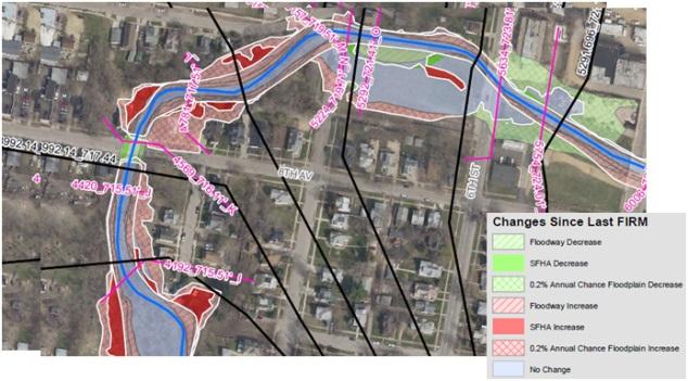


5 Publications FEMA s Toolbox Mitigation Action Tracker Education Hazard Mitigation Plans Depth Grids Discovery Products Changes Since Last FIRM 5
6 What Is CRS? FEMA National Flood Insurance Program Administered by ISO (Insurance Services Office) Recognition for Going Above and Beyond Minimum NFIP Standards with Reduce Flood Insurance Premiums Voluntary Program with Community Activities for Point Accumulation Based on a 10 Class System. 500 Points & 5% Discount / Class Local Floodplain Management Program More Organized. Free Technical Assistance for Certain Activities Better Educated Public Reduced Flood Damage and Faster Recovery 6
7 Premium Discounts Class Points SFHA Non-SFHA 1 4,500 45% 10% 2 4,000 40% 10% 3 3,500 35% 10% 4 3,000 30% 10% 5 2,500 25% 10% 6 2,000 20% 10% 7 1,500 15% 5% 8 1,000 10% 5% % 5%
8 Upper Fox CRS Communities Community/County Rating Premium Discount Carpentersville / Kane 6 20% Crystal Lake / McHenry 6 20% Lake In The Hills / McHenry 6 20% Lake County 6 20% McHenry County 8 10% 8
9 Public Information CRS Activities Mapping & Regulatory Flood Damage Reduction Warning & Response 9
10 Public Information Hazard Mitigation Plans & CRS Kane County Public Information Activities Municipality Community newsletter Website Website links for hazards Technical assistance Algonquin Yes Yes Yes No Aurora Yes Yes Yes Yes Batavia Yes Yes Yes Yes Big Rock Yes Yes Yes No Burlington No No N/A No Campton Hills Yes Yes Yes No Carpentersville Yes Yes No No East Dundee Yes Yes No Yes Elburn No Yes No No Elgin Yes Yes No Yes Geneva Yes Yes Yes Yes Gilberts Yes Yes Yes Yes Hampshire No Yes No No Huntley Yes Yes No Yes Kane County No Yes Yes Yes Kaneville No Yes No No Lily Lake Yes No N/A No Maple Park Yes Yes No No Montgomery Yes Yes No Yes North Aurora Yes Yes No Yes Pingree Grove Yes Yes No No Sleepy Hollow Yes Yes No No South Elgin Yes Yes No Yes St. Charles Yes Yes No Yes Sugar Grove Yes Yes Yes No Virgil No No No No Wayne Yes No N/A No West Dundee Yes Yes No No CRS credit: The Community Rating System provides up to 290 points for outreach projects on flood topics. 100 of those points are for having a public information program strategy. This Plan qualifies for the strategy credit (see Section 9.6). 10
11 Public Information Hazard Mitigation Plans & CRS Local implementation: Community libraries in the Village of Algonquin, the Village of Cary, the City of Marengo, and the City of McHenry provides information on hazards and hazard mitigation. The Village of Algonquin, the Village of Lakewood, and the City of McHenry provide web site links to hazard information and hazard mitigation. Action Item 3: Improve Natural Hazards Public Information Efforts Education regarding natural hazards that can impact Lake County should be provided to all Lake County property owners and residents. A number of public information efforts have been implemented, but these efforts should be improved to more effectively reach people and to provide effective messages regarding life, health and safety and property protection. Public information and education efforts should focus on severe summer and winter storms, floods and tornadoes and materials should be developed specifically for Lake County and tailored to Lake County needs. CRS credit: The Community Rating System provides up to 30 points for having a variety of flood references in the local public library and up to 36 more for similar material on municipal web sites. 11
12 Flood Damage Reduction Hazard Mitigation Plans & CRS Local implementation: Aurora and East Dundee have plans to do additional local drainage system improvements in the Blackberry Creek and Fox River watersheds, respectively. These efforts are to alleviate problems during heavy local rains Double 18-inch concrete culverts were replaced with double 36-inch concrete culverts on No Name Creek in East Dundee in East Dundee has additional plans to replace double 18-inch CMP culverts about 100 feet upstream of this location. CRS Criteria: The Community Rating System credits capital improvement plans that fund drainage improvements that reduce the need for maintenance or that eliminate bottlenecks, logjams and other maintenance problems. Up to 50 points are provided 12
13 Flood Damage Reduction Hazard Mitigation Plans & CRS Lake County ANHMP Action Item 9: Property Protection Projects Properties that are exposed to flood damage and severe storms throughout Lake County should be protected through property protection measures where regional structural projects are not feasible. Property protection measures should include, but not be limited to, acquisition, elevation, floodproofing, or retrofitting. Priority should be given to repetitive loss properties, but all flood prone properties (floodplain, depressional storage or SMC problem areas) including critical facilities should be included. Action Item 14: Improve Capacity of Drainage Systems When opportunities arise and when downstream areas are not adversely impacted (or mitigated), communities should strive to increase the capacity of drainage systems. Drainage improvements may include opening up restrictive culverts or bridges, storm sewer improvements, etc 13
14 Mapping and Regulatory Hazard Mitigation Plans & CRS Table 4-3 McHenry Countywide Stormwater Ordinance Certified Community Status Municipality: Status: Village of Algonquin Kane Village of Barrington Hills Non-Certified Village of Bull Valley Non-Certified Village of Cary Non-Certified City of Crystal Lake Certified Village of Fox Lake Lake-part Village of Fox River Grove Non-Certified Village of Greenwood Non-Certified City of Harvard Non-Certified Village of Hebron Certified Village of Holiday Hills Non-Certified Village of Huntley Kane Village of Island Lake Lake-full Village of Johnsburg Certified Village of Lake in the Hills Certified Village of Lakemoor Non-Certified Village of Lakewood Certified City of Marengo Certified Village of McCullom Lake Certified City of McHenry Certified Village of Oakwood Hills Non-Certified Village of Port Barrington Lake-part Village of Prairie Grove Certified Village of Richmond Certified Village of Ringwood Certified Village of Spring Grove Certified Village of Trout Valley Non-Certified Village of Union Certified Village of Wonder Lake Certified City of Woodstock Certified The County and all municipalities should receive at least 300 points for these provisions of the McHenry County Stormwater Ordinance. They certainly exceed minimum State and Federal requirements. 14
15 Mapping and Regulatory Hazard Mitigation Plans & CRS Action Item 4: SMC Flood Mitigation Projects Based on the findings in Chapter 3 of this ANHMP, it is important for the Lake County SMC to continue with their watershed management efforts for the purpose of flood mitigation in unincorporated Lake County and within the Lake County municipalities. b. Priority actions for the Fox River Watershed in the next five years include Floodplain buyout program Floodplain remapping/studies for Fish Lake Drain, Sequoit Creek, Squaw Creek, and Round Lake Drain/Eagle Creek/Long Lake Watershed planning/coordination for Fish Lake Drain 15
16 Warning and Response Hazard Mitigation Plans & CRS Action Item 5: Development of Flood Stage Maps Flood stage maps should be developed to show varying depths of flooding and the respective area of inundation for floodplain areas within Lake County s major watersheds. The maps should be developed by watershed based on available hydrologic and hydraulic models. Flood stage maps can be used by all agencies to determine early protection actions. Benefits: Flood stage mapping would provide a depiction of the most at-risk structures, intersections, and utilities in the floodplain. They would aid in mitigation project planning. Most importantly, they would provide data for emergency response (and response planning) and allow communities to assess and identify needed resources 16
17 How To Join ISO/CRS Must be NFIP Compliant Specialist will help w/ application Document Activities you choose

18 CRS Contact Information Lou Ann Patellaro

19 Discovery Products c lick on 19

20 Upper Fox Watershed Discovery 20

21 Upper Fox Discovery Database 21

22 Mitigation Action Tracker (MAT) The Mitigation Action Tracker (MAT) is a Web-based tool used to capture, store, organize and track mitigation actions. Community officials are encouraged to utilize this tool as a resource for organizing and tracking potential mitigation actions in their community. Numerous mitigation actions have been entered as part of our follow up work after Risk MAP Discovery meetings. 22
Kane County Natural Hazards Mitigation Committee
 Kane County Natural Hazards Mitigation Committee Annual Report For 2004 TO: Members of the Kane County Board FROM: Kane County Natural Hazards Mitigation Committee SUBJECT: Annual Report for 2004 Date:
Division of Environmental Health. Prevention of Disease from Exposure to Environmental Hazards
 Division of Environmental Health Prevention of Disease from Exposure to Environmental Hazards McHenry County Public Health Ordinance State/National Standards Illinois Department of Public Health Food Protection
Overview of Agriculture in Kane County. Kane County Agriculture Committee February 19, 2013
 Overview of Agriculture in Kane County Kane County Agriculture Committee February 19, 2013 Agriculture in Kane County Kane County includes approximately 522 square miles or 334,000 acres. The county s
2018 Progress Report Following the 2017 Land Acquisition & Preserve Improvement Referendum
 2018 Progress Report Following the 2017 Land Acquisition & Preserve Improvement Referendum FOREST PRESERVE DISTRICT OF KANE COUNTY 1 2017 Referendum Recap... Part of our success: good timing Because of
Natural Hazards Mitigation Plan Kankakee County, Illinois Executive Summary
 1. Introduction Natural Hazards Mitigation Plan Kankakee County, Illinois Executive Summary Kankakee County s first Natural Hazards Mitigation Plan was adopted by the Kankakee County Board on October 11,
AGENDA COMMITTEE OF THE WHOLE COUNTY OF KANE
 AGENDA COMMITTEE OF THE WHOLE COUNTY OF KANE Tuesday, April 30, 2013 4:00 p.m. County Board Room Bldg. A A. CALL TO ORDER B. ROLL CALL C. PLEDGE OF ALLEGIANCE & PRAYER D. APPROVAL OF MINUTES: March 26,
Longmeadow Parkway Fox River Bridge Corridor. Kane County Board Committee of the Whole July 25, 2007
 Longmeadow Parkway Fox River Bridge Corridor Kane County Board Committee of the Whole July 25, 2007 Purpose of Presentation On the behalf of 11 local communities in the northern Fox Valley, we are requesting
2040 Long Range Transit Plan
 KANE COUNTY LONG RANGE TRANSIT PLAN 2040 Long Range Transit Plan ADOPTED JUNE 14, 2011 KANE COUNTY LONG RANGE TRANSIT PLAN CONTENTS Executive Summary...ES-1 Project Overview... ES-3 Existing Conditions
Watersheds, Hydrology and Flooding
 Watersheds, Hydrology and Flooding Greg Karlovits, P.E., CFM Hydrologist US Army Corps of Engineers Rock Island District US Army Corps of Engineers Outline of Topics Before lunch: Watersheds and basics
Table G - 7. Mitigation Actions Identified for Implementation by the City of Eyota ( ) (From Olmsted County Master Mitigation Action Chart)
 (From Olmsted County Master Mitigation Action Chart)") Multi-Hazard Plan, 2017 Table G - 7. Actions Identified for by the City of () (From Master Action Chart) City of Action Comments on 1 All- Hazards Preparedness & Response Support Identify and map locations
Multi-Hazard Plan, 2017 Table G - 7. Actions Identified for by the City of () (From Master Action Chart) City of Action Comments on 1 All- Hazards Preparedness & Response Support Identify and map locations
2014 Annual Evaluation Report
 2014 Annual Evaluation Report 1 Lake County, IL All Natural Hazards Mitigation Plan Action Items 1 Plan Adoption 2 Mitigation Planning Committee 3 Improve Natural Hazards Public Information Efforts 4 SMC
Illinois Valley Flood Resiliency Alliance. Senator Sue Rezin, 38 th Senatorial District
 Illinois Valley Flood Resiliency Alliance Senator Sue Rezin, 38 th Senatorial District August, 2007 March, 2009 APRIL 19, 2013 Senator Rezin APRIL 21, 2013 Governor Quinn Mayor Eschbach Rep. Frank Mautino
HAZARD MITIGATION ASSISTANCE
 FEDERAL INSURANCE ANDMITIGATION ADMINISTRATION HAZARD MITIGATION ASSISTANCE New Partners for Smart Growth Conference - February 3, 2018 Jennie Orenstein, FEMA HQ 1 Objectives By the end of this session
Village of Gurnee, Illinois Flood Mitigation Plan. Executive Summary. November 15, Flood Mitigation Planning Committee
 Village of Gurnee, Illinois Flood Mitigation Plan Executive Summary November 15, 2001 Flood Mitigation Planning Committee The Lake County Stormwater Management Commission (SMC) has initiated a program
Watershed Planning in Blackberry Creek We Save Land. We Save Rivers.
 Watershed Planning in Blackberry Creek We Save Land. We Save Rivers. What is a watershed? The area of land that catches rain and snow and drains into a stream, river, lake or groundwater. How land is used
Lower Fox River Watershed Discovery Report
 Lower Fox River Watershed Discovery Report Prepared for the Federal Emergency Management Agency By Illinois State Water Survey November 2011 Updated January 28, 2015 BLANK PAGE Discovery Report for Lower
Kane County Natural Hazards Mitigation Committee
 Kane County Natural Hazards Mitigation Committee Annual Report For 2007 Natural Hazardous Mitigation Plan 2007 Annual Report page 1 TO: Members of the Kane County Board FROM: Kane County Natural Hazards
Climate Smart Resiliency Plans, Policies, and Projects Improvement Plan for: The Town of Caroline
 Climate Smart Resiliency Plans, Policies, and Projects Improvement Plan for: The Town of Caroline Overview This document should serve as a supplement to the Climate Smart Resiliency Planning Evaluation
DRAINAGE MASTER PLAN FOR THE TOWN OF BLOOMING GROVE AND VILLAGES OF WASHINGTONVILLE AND SOUTH BLOOMING GROVE
 DRAINAGE MASTER PLAN FOR THE TOWN OF BLOOMING GROVE AND VILLAGES OF WASHINGTONVILLE AND SOUTH BLOOMING GROVE PUBLIC MEETING March 8, 2017 LOGISTICS Meeting Agenda: Presentation (7:15 7:45 pm) [Auditorium]
Base Level Engineering Elizabeth Savage, RPML, H2O Partners Diane Howe, FEMA Region 6. May 4, 2017
 Base Level Engineering Elizabeth Savage, RPML, H2O Partners Diane Howe, FEMA Region 6 May 4, 2017 What is Base Level Engineering Measuring stick to allow FEMA to assess its current flood maps. Cursory
CHAPTER 3 FLOOD RELATED STUDIES
 CHAPTER 3 FLOOD RELATED STUDIES Although the area has experienced regular flooding there have been few formal flood studies until more recently. There are a number of water quality studies in the basins.
SECTION VIII PLAN MAINTENANCE AND EVALUATION
 SECTION VIII PLAN MAINTENANCE AND EVALUATION 44 Code of Federal Regulations 44 CFR 201.6(c)(4)(i): A section describing the method and schedule of monitoring, evaluating, and updating the mitigation plan
Table D-1. Montour County Hazard Mitigation Projects - Municipalities Affected. Structural Projects
 Table D-1 Montour County Hazard Mitigation Projects - Municipalities Affected Structural Projects Project Description Mitigation Objective Hazard Municipality(s) Affected Pursue re-mapping of the 100-year
COUNTY OF KANE. Kishwaukee River Headwaters Study Stakeholder Meeting Monday, February 26, :30 am Hampshire Village Hall
 COUNTY OF KANE ENVIRONMENTAL AND BUILDING MANAGEMENT Timothy Harbaugh, P.E., DEE Director County Government Center 719 Batavia Avenue Geneva, IL 60134 www.co.kane.il.us Environmental Management: (630)
Hackensack River Flood Reduction Study Update
 Township of River Vale Hackensack River Flood Reduction Study Update November 11, 2013 Purpose of Study To Analyze Where Frequent Flooding Is Impacting Property and How It Might Be Reduced Hackensack River
CC-530EHP Flood Protection
 CC-530EHP Flood Protection Compliance with Environmental and Historic Preservation Requirements (see Section 531.b(4) in the CRS Coordinator s Manual) NOTE: The self-certification of compliance with environmental
CITY OF ANGLETON MASTER DRAINAGE PLAN PHASE I EVALUATION & PRELIMINARY REPORT
 CITY OF ANGLETON MASTER DRAINAGE PLAN PHASE I EVALUATION & PRELIMINARY REPORT February 2008 Prepared by STOKES & ASSOCIATES, INC. 605 South Main Street, Suite 200 Henderson, Texas 75654 903-657-7558 TABLE
AS A COURTESY, PLEASE TURN OFF CELL PHONES AND PAGERS WHILE MEETING IS IN PROGRESS.
 Table of Contents Agenda 2 Wastewater Treatment Plant (WWTP) Hydraulic Capacity Update Staff Report 3 WWTP Capacity Outline 5 WWTP Capacity Charts 6 Drainage Concerns on Oak Hill Drive and Quail Drive
Will County Site Development Permit Submittal Checklist TAB 1 PROJECT OVERVIEW
 Applicant: Reviewer: Permit No.: The following tables contain a checklist of the requirements before a review for a Site Development Permit submittal will be accepted. Not all requirements pertain to every
INDIAN CREEK WATERSHED PLAN EXECUTIVE SUMMARY
 INDIAN CREEK WATERSHED PLAN EXECUTIVE SUMMARY The Indian Creek Watershed covers a 38 square mile area in southern Lake County, Illinois that drains 24,116 acres before discharging into the Des Plaines
DRAINAGE AND NATURAL AQUIFER GROUNDWATER RECHARGE ELEMENT
 Goal 7.0. To optimize integrated stormwater management in order to reduce damage and impacts from sea level rise and flooding, promotes recharge to the Surficial Aquifer System (SAS), improve and protect
Coordinated Hazard Assessment and Mapping Program
 Coordinated Hazard Assessment and Mapping Program Mississippi River flood, 1993 A PREDICTABLE DISASTER Floods are the most common natural disaster in Illinois, accounting for well over 90% of declared
ODOT Floodplain Management. Jeffrey Syar, P.E., Administrator, Central Office,Hydraulic Engineering
 ODOT Floodplain Management Jeffrey Syar, P.E., Administrator, Central Office,Hydraulic Engineering John R. Kasich, Ohio Governor Jerry Wray, ODOT Director Background NFIP Ohio Department of Natural Resource
Tipton Flood Resilience Plan - Strategies for Smart Growth and Long-Term Flood Risk Reduction
 Tipton Flood Resilience Plan - Strategies for Smart Growth and Long-Term Flood Risk Reduction An Action Discovery Project as part of the Upper White River Watershed Discovery Report Presented by: Siavash
No Adverse Impact Floodplain Management
 No Adverse Impact Floodplain Management June 6, 2013 Beth Lucas, Senior Planner Broome County Planning No Adverse Impact Developed by Association of State Floodplain Managers Purposes: Address the shortcomings
CARSON CITY STORM WATER MANAGEMENT PROGRAM & CIP
 CARSON CITY STORM WATER MANAGEMENT PROGRAM & CIP Public Works Department March 14, 2013 Activity and Event Timeline Freeway CLOMR Submitted 1997 New Year s Flood Freeway By Pass Project Begins 1997 1998
Kane County Natural Hazards Mitigation Committee
 Kane County Natural Hazards Mitigation Committee Annual Report For 2016 TO: FROM: Members of the Kane County Board Kane County Natural Hazards Mitigation Committee Co-Chair Co-Chair Sean Madison Cecilia
Innovative Stormwater Master Planning for the Town of Cary
 Innovative Stormwater Master Planning for the Town of Cary Charles Brown, CPESC, CFM Stormwater Program Analyst, Town of Cary Scott Brookhart, PE, CFM Michael Baker Engineering, Inc. Todd St. John, PE,
Handout #1 Draft Action Plan City of Los Angeles Floodplain Management Plan 2015 Update
 P-1 Maintain the City Tsunami Response Plan Annex and community education effort and participate in the Los Angeles County Operational Area Tsunami Mitigation Task Force. EMD, HD General, HD Low. Work
3.1 Problem Statements, Goals, Objectives and Action Items
 3.0 Mitigation Plan Hazard mitigation planning is the coordination of actions taken to reduce injuries, deaths, property damage, economic losses, and degradation of natural resources due to natural or
Carbon Creek Channel (OCFCD Facility No. B01) from upstream Intersection of Western/Orange to upstream Beach Boulevard.
 from upstream Intersection of Western/Orange to upstream Beach Boulevard.") Carbon Creek Channel (OCFCD Facility. B01) from Lead Agency: Agency: Project Director: Address: Orange County, Public Works, Infrastructure Programs, Capital Programs Sam Ali 300 N. Flower Street Santa
Carbon Creek Channel (OCFCD Facility. B01) from Lead Agency: Agency: Project Director: Address: Orange County, Public Works, Infrastructure Programs, Capital Programs Sam Ali 300 N. Flower Street Santa
Lower Fox River Watershed Discovery Report
 Miscellaneous Publication 197 Lower Fox River Watershed Discovery Report December 2011 Illinois State Water Survey Prairie Research Institute University of Illinois at Urbana-Champaign Champaign, Illinois
SECTION 6: MITIGATION STRATEGIES
 SECTION 6: MITIGATION STRATEGIES This section presents mitigation actions for Onondaga County to reduce potential exposure and losses identified as concerns in the Risk Assessment portion of this plan.
Proactive Planning for Resilient Coasts Lessons for North Texas
 Proactive Planning for Resilient Coasts Lessons for North Texas Kimberly M. Miller, Senior Planner & Operations Manager, Allen Engineering and Science Overview of Today s Program 1. Planning for Coastal
Floodplain management uses various tools to
 Fort Collins Floodplain Management Program Success Stories from the September 2013 Flood Marsha Hilmes-Robinson, Floodplain Administrator, City of Fort Collins Utilities Chris Lochra, Flood Warning Engineer,
Section 6: Stormwater Improvements
 Section 6: Stormwater Improvements A major objective of this study was to identify opportunities for improvements to address the widespread water quality impairments caused by stormwater runoff in the
PRINCESS ANNE DISTRICT STORMWATER PROJECTS
 PRINCESS ANNE DISTRICT STORMWATER PROJECTS Topics o o o o o Sea Level Rise and the Southern Watersheds Ashville Park Sherwood Lakes Kingston Estates Drainage Operations & Maintenance in the Southern Watersheds
Surface Water Availability in Kane County
 Surface Water Availability in Kane County H. Vernon Knapp, P.E. Illinois State Water Survey Illinois Department of Natural Resources What Factors Most Affect Low Flows and Surface Water Availability for
New Castle County, DE. Floodplain Regulations
 New Castle County, DE Floodplain Regulations John J. Gysling, PE CFM Department of Land Use New Castle County, DE February 26, 2009 Today s Presentation Floodplain Protection and Uses Terms and Definitions
Flood Mitigation Plan
 City of Huntsville, Alabama Flood Mitigation Plan 2001 Prepared by Flood Mitigation Planning Committee June 1, 2001 City of Huntsville, Alabama Flood Mitigation Plan Executive Summary 1973 1999 Prepared
A Narrative Description of San Anselmo s Flood Hazard (Copied from the draft 2015 Hazard Mitigation Plan)
") A Narrative Description of San Anselmo s Flood Hazard (Copied from the draft 2015 Hazard Mitigation Plan) Town of San Anselmo FEMA Flood Zones Description The Town of San Anselmo is subject to periodic
A Narrative Description of San Anselmo s Flood Hazard (Copied from the draft 2015 Hazard Mitigation Plan) Town of San Anselmo FEMA Flood Zones Description The Town of San Anselmo is subject to periodic
NORTHAMPTON COUNTY MITIGATION STRATEGIES
 Eastern Shore of Virginia Hazard Mitigation Plan NORTHAMPTON COUNTY MITIGATION STRATEGIES Northampton County is the southernmost county on the Eastern Shore of Virginia. There are 6 towns within the county.
DEKALB COUNTY STORMWATER MANAGEMENT PLAN PHASE 2
 DEKALB COUNTY STORMWATER MANAGEMENT PLAN PHASE 2 Introduction DeKalb County, Illinois, located approximately 50 miles west of Lake Michigan, is rectangular in shape, with a north/south dimension of 36
Type of Problem. All existing and anticipated future problems/concerns. Building Flooding Drainage Issue Street Flooding Restrictive Structure
 Jeffersonville Stormwater Master Plan (SWMP) Advisory Committee Meeting Worksheet (1/10/12) SUMMARY OF SUGGESTED TARGET STUDY AREAS & PROMISING SOLUTIONS FOR EVALUATION IN PHASE 2 Problem Area Name 1 Existing
STORMWATER MANAGEMENT GOALS, OBJECTIVES, AND POLICIES
 STORMWATER MANAGEMENT GOALS, OBJECTIVES, AND POLICIES GOAL 1: The City of North Port shall provide a stormwater management system which protects real and personal properties, preserves natural resources,
Joseph E. Boxhorn, Ph.D., Senior Planner Southeastern Wisconsin Regional Planning Commission
 1976 Washington County Ice Storm # 237316 Joseph E. Boxhorn, Ph.D., Senior Planner Southeastern Wisconsin Regional Planning Commission 1940 Slinger Flooding Plan Documentation 1981 West Bend Tornado SEWRPC
SECTION 11: REGULATORY FLOODWAYS
 SECTION 11: REGULATORY FLOODWAYS Contents 11.1. The Floodway... 11-2 11.1.1. The floodway concept... 11-2 11.1.2. Floodway map... 11-2 11.1.3. Floodway permitting... 11-3 11.1.4. Changing the floodway...
CITY OF LEBANON CITY WIDE DRAINAGE EVALUATION EXECUTIVE SUMMARY
 CITY OF LEBANON CITY WIDE DRAINAGE EVALUATION EXECUTIVE SUMMARY Introduction Neel-Schaffer performed an engineering evaluation of drainage issues and flooding concerns within the City of Lebanon (City)
CREEKS OF THE MIDDLE FOX RIVER 2016 Progress Report
 CREEKS OF THE MIDDLE FOX RIVER 2016 Progress Report Brewster approximately three years after dam removal Presented by the Sierra Club Valley of the Fox Water Sentinels ILLINOIS CHAPTER PRESERVING THE FOX
Go Green, Save Money: Lowering Flood Insurance Rates in Virginia with Stormwater Management. Kristen Clark VCPC Alumna, Spring 2014
 Go Green, Save Money: Lowering Flood Insurance Rates in Virginia with Stormwater Management Kristen Clark VCPC Alumna, Spring 2014 Rising Waters, Rising Rates Coastal Communities in Virginia are confronted
Stream Buffers Sharpest Tool in the SWM Toolbox Tom Hegemier, PE, D.WRE, CFM
 Stream Buffers Sharpest Tool in the SWM Toolbox 1 Tom Hegemier, PE, D.WRE, CFM www.apaienv.com Stream Buffers - Overview 2 Why stream buffers? Floodplain management and other benefits Existing regulatory
CLINTON COUNTY HAZARD MITIGATION PLAN
 CLINTON COUNTY HAZARD MITIGATION PLAN PREPARED FOR CLINTON COUNTY DEPARTMENT OF EMERGENCY SERVICES 22 CREE DRIVE LOCK HAVEN, PA 17745 PREPARED BY THE CLINTON COUNTY HAZARD MITIGATION TEAM Executive Summary
FOX RIVER WATERSHED INVESTIGATION
 October 14, 2014 Alena Bartosova, Illinois State Water Survey FOX RIVER WATERSHED INVESTIGATION ACKNOWLEDGMENTS Fox River Study Group, Inc. Fox Metro WRD, Fox River WRD, City of Aurora, City of Elgin,
4. Present Activities and Roles
 4. Present Activities and Roles The present missions, authorities, activities and roles of the various agencies involved with flood protection, floodplain management and flood-damage reduction are identified
Lower Fox Discovery Meeting Comments - November 2010
 Lower Fox Discovery Meeting Comments - November 2010 Comment Marked Map Submitted by Community Comment 4 n/a Cody Wright/Red Cross 7 n/a Pat Vary/ Board Many emergency services, departments, and agencies
CHAPTER 5 MITIGATION STRATEGY
 CHAPTER 5 MITIGATION STRATEGY This section describes the mitigation strategy process and mitigation action plan for the Dane County. This section describes how the County accomplished Phase 3 of FEMA s
Ocean View Channel (OCFCD Facility No. C06) from downstream of Bushard Street to downstream of Brookhurst Street
 from downstream of Bushard Street to downstream of Brookhurst Street") Ocean View Channel (OCFCD Facility. C06) from Lead Agency: Agency: Project Director: Address: Orange County, Public Works, Infrastructure Programs, Capital Programs Sam Ali 300 N. Flower Street Santa Ana
Ocean View Channel (OCFCD Facility. C06) from Lead Agency: Agency: Project Director: Address: Orange County, Public Works, Infrastructure Programs, Capital Programs Sam Ali 300 N. Flower Street Santa Ana
TOWN OF KILL DEVIL HILLS, NORTH CAROLINA ANNUAL PROGRESS REPORT ON ADOPTED HAZARD MUTIGATION PLAN COMMUNITY #
 TOWN OF KILL DEVIL HILLS, NORTH CAROLINA ANNUAL PROGRESS REPORT ON ADOPTED HAZARD MUTIGATION PLAN COMMUNITY # 375353 Since the last application for continued participation in the Community Rating System
COON CREEK WATERSHED DISTRICT PERMIT REVIEW Mississippi Dr Coon Rapids, MN SQ FT Residence on 0.64 Acre Lot
 17-082 Van Sloun Residence, Page 1 of 5 COON CREEK WATERSHED DISTRICT PERMIT REVIEW MEETING DATE: May 8, 2017 AGENDA NUMBER: 17 FILE NUMBER: 17-082 ITEM: Van Sloun Residence RECOMMENDATION: Approve with
ANCR INDIVIDUAL RESPONSES SUMMARY: 2/11/04 WATER RESOURCES GOALS AND OBJECTIVES
 ANCR INDIVIDUAL RESPONSES SUMMARY: 2/11/04 WATER RESOURCES GOALS AND OBJECTIVES Goal 1: Protect the health and safety of the Dane County population. a. Prevent development that may have an adverse effect
Climate Impacts and Action
 Climate Impacts and Action Green/Duwamish Watershed Advisory Group January 21 st, 2016 Matt Kuharic Senior Climate Change Specialist DNRP Director s Office www.kingcounty.gov/climate 1 Climate Impacts
What to Expect When You re Expecting A LOMR. Mark Seidelmann, PE, GISP ASFPM 2015, Atlanta Georgia
 What to Expect When You re Expecting A LOMR Mark Seidelmann, PE, GISP ASFPM 2015, Atlanta Georgia Thursday, June 4 th, 2015 Agenda 1 Why File a Letter Of Map Revision (LOMR)? 2 Basic Requirements and Common
TOWN OF BRANFORD COASTAL RESILIENCE PLAN
 TOWN OF BRANFORD COASTAL RESILIENCE PLAN Presentation of the Plan Janice Plaziak, P.E., Town of Branford David Murphy, P.E., CFM, Milone & MacBroom, Inc. Scott Choquette, CFM, Dewberry Town of Branford,
Notice of Intent for New or Renewal of General Permit for Discharges from Small MS4s Preamble
 Preamble PREAMBLE to NOTICE OF INTENT FOR NEW OR RENEWAL OF GENERAL PERMIT FOR DISCHARGES FROM SMALL MUNICIPAL SEPARATE STORM SEWER SYSTEMS - MS4S describing LAKE COUNTY S COUNTYWIDE APPROACH TO STORMWATER
I. Welcome & Introductions WPAC History (Paul Racette, PEC)
") Poquessing Creek Watershed ACT 167 STORM WATER MANAGEMENT PLAN Public Hearing July 10, 2012 I. Welcome & Introductions ---------- WPAC History (Paul Racette, PEC) Primary WPAC Members: Bucks County: Bensalem
Poquessing Creek Watershed ACT 167 STORM WATER MANAGEMENT PLAN Public Hearing July 10, 2012 I. Welcome & Introductions ---------- WPAC History (Paul Racette, PEC) Primary WPAC Members: Bucks County: Bensalem
 ASHVILLE PARK STORMWATER UPDATE JULY 18, 2017 1 ASHVILLE PARK CHRONOLOGY 2005: Ashville Park conditionally rezoned. Consisted of Five Villages 2006-2007: Village A Wilshire Village was approved and construction
Flooding - Tidal and Rainfall. Presentation to City Council Informal Session May 24, John M. Keifer PE
 Flooding - Tidal and Rainfall Presentation to City Council Informal Session May 24, 2011 John M. Keifer PE Purpose of Presentation 1. Review flooding causes and implications to the City 2. Discuss mitigation
THE WATER IS RISING SCALABLE, RELIABLE, AND RELEVANT INFORMATION SUPPORTING FIRST RESPONDERS. May 3, 2017
 THE WATER IS RISING SCALABLE, RELIABLE, AND RELEVANT INFORMATION SUPPORTING FIRST RESPONDERS May 3, 2017 Association of State Floodplain Managers 2017 Conference Jim Keith, PE, CFM Walter P Moore Andy
CRYSTAL LAKE FLOODING STUDY EXECUTIVE SUMMARY
 Project #08223 CRYSTAL LAKE FLOODING STUDY EXECUTIVE SUMMARY PREPARED FOR: City of Crystal Lake 100 West Woodstock Street Crystal Lake, Illinois 60014 FEBRUARY 11, 2009 26575 W. COMMERCE DRIVE, SUITE 601,
NORTHAMPTON COUNTY MITIGATION STRATEGIES
 Eastern Shore of Virginia Hazard Mitigation Plan NORTHAMPTON COUNTY MITIGATION STRATEGIES Northampton County is the southernmost county on the Eastern Shore of Virginia. There are 6 towns within the county.
GETTING STARTED: LEVERAGING FUNDING SOURCES TO CREATE OPPORTUNITIES KAMM CONFERENCE August 24, 2016 Presented By: Sarah Taylor
 GETTING STARTED: LEVERAGING FUNDING SOURCES TO CREATE OPPORTUNITIES 2016 KAMM CONFERENCE August 24, 2016 Presented By: Sarah Taylor OVERVIEW Do I really have a problem? Identifying the need Finding the
REGULATING POO Public and Private Waste Disposal in the Floodplain.
 REGULATING POO Public and Private Waste Disposal in the Floodplain. Mike Prough, Jersey County Code Administrator Paul Osman, Illinois Office of Water Resources The Local Ordinance Regulates: Construction
City of Fortuna Rohner Creek Flood Control Project
 City of Fortuna Rohner Creek Flood Control Project Presented To: Fortuna City Council Special Session April 26, 2013 Presented By: Merritt Perry, PE Jeremy Svehla, PE Robert Holmlund, AICP Presentation
CHAPTER 3. Mitigation Strategy: Goals, Objectives, and Initiatives. 3.0 Introduction
 CHAPTER 3 Mitigation Strategy: Goals, Objectives, and Initiatives 3.0 Introduction The mitigation strategy is this plan s call to action, serving as the blueprint for reducing losses and impacts from the
Plan Rollout Presentation July 31, Michael G. Hahn, P.E., P.H. Chief Environmental Engineer. Southeastern Wisconsin Regional Planning Commission
 Plan Rollout Presentation July 31, 2014 Michael G. Hahn, P.E., P.H. Chief Environmental Engineer Southeastern Wisconsin Regional Planning Commission # 219703 Racine County Flooding Recommendations and
HAZARD MITIGATION PLANNING
 HAZARD MITIGATION PLANNING October 5, 2016 Joseph Boxhorn, Ph.D., Senior Planner Southeastern Wisconsin Regional Planning Commission DOCS #232977 What is Mitigation? Mitigation is any sustained action
3F. Hydrology and Water Quality
 This section provides an analysis of potential hydrological and water quality impacts associated with implementation of the proposed project. The section also evaluates and describes the potential impacts
Fullerton Creek Channel (OCFCD Facility No. A03) from downstream Beach Blvd. including undercrossing to downstream I-5 Freeway.
 from downstream Beach Blvd. including undercrossing to downstream I-5 Freeway.") Fullerton Creek Channel (OCFCD Facility. A03) Lead Agency: Agency: Project Director: Address: Orange County, Public Works, Infrastructure Programs, Capital Programs Sam Ali 300 N. Flower Street Santa Ana
Fullerton Creek Channel (OCFCD Facility. A03) Lead Agency: Agency: Project Director: Address: Orange County, Public Works, Infrastructure Programs, Capital Programs Sam Ali 300 N. Flower Street Santa Ana
Technical Assistance for Action Advancement: Indiana Success Stories. Session J4: Mitigation Project Successes 2 ASFPM Conference June 23, 2016
 Technical Assistance for Action Advancement: Indiana Success Stories Session J4: Mitigation Project Successes 2 ASFPM Conference June 23, 2016 Presentation Outline Overview Map Mod vs. Risk MAP Phased
CRS Comments from the Colorado Association of Stormwater and Floodplain Managers
 CRS Comments from the Colorado Association of Stormwater and Floodplain Managers March 10, 2016 Specific Activity Comments 1. Activity 330 - PPI adoption by Governing Board: We understand the desire for
BCWMC Capital Improvement Program (Approved with Minor Plan Amendment July 2017)
") BCWMC Capital Improvement Program 2019 2023 (Approved with Minor Plan Amendment July 2017) Project Name City Number 2016 2017 2018 2019 2020 2021 2022 2023 Totals Honeywell Pond Expansion, Main Stem Watershed
BCWMC Capital Improvement Program 2019 2023 (Approved with Minor Plan Amendment July 2017) Project Name City Number 2016 2017 2018 2019 2020 2021 2022 2023 Totals Honeywell Pond Expansion, Main Stem Watershed
Stormwater Management Program Review
 Stormwater Management Review Comprehensive Stormwater Management Mission Statement The mission of the CSMP is to develop and maintain a comprehensive watershed and stormwater infrastructure management
KANE COUNTY SOLID WASTE MANAGEMENT PLAN FIVE YEAR UPDATE. November, 1997 VOLUME 1. Adopted by the Kane County Board
 KANE COUNTY SOLID WASTE MANAGEMENT PLAN FIVE YEAR UPDATE November, 1997 VOLUME 1 Prepared by the Kane County Department of Environmental Management Geneva, Illinois Adopted by the Kane County Board 1997
SUGAR CREEK WATERSHED PLAN
 SUGAR CREEK WATERSHED PLAN August 2018 Table of Contents Section 1 Introduction... 1-1 Watersheds... 1-1 What is a Watershed?... 1-1 Why Use a Watershed Approach?... 1-2 What is a Watershed Plan?... 1-3
ASHVILLE PARK STORMWATER UPDATE
 ASHVILLE PARK STORMWATER UPDATE JULY 18, 2017 1 ASHVILLE PARK CHRONOLOGY 2005: Ashville Park conditionally rezoned. Consisted of Five Villages 2006-2007: Village A Wilshire Village was approved and construction
Little Bear Brook Flood Hazard Assessment and Redevelopment Area Regional Stormwater Management Analysis. Progress Meeting
 Little Bear Brook Flood Hazard Assessment and Redevelopment Area Regional Stormwater Management Analysis Progress Meeting June 30, 2014 Princeton Hydro, LLC and SWM Consulting, LLC Project Team West Windsor
Lessons [being] learnt 2016 Flood in Cedar Rapids. Sandy Pumphrey Project Engineer II Flood Mitigation
![Lessons [being] learnt 2016 Flood in Cedar Rapids. Sandy Pumphrey Project Engineer II Flood Mitigation](/thumbs/77/74998790.jpg "Lessons [being] learnt 2016 Flood in Cedar Rapids. Sandy Pumphrey Project Engineer II Flood Mitigation") Lessons [being] learnt 2016 Flood in Cedar Rapids Sandy Pumphrey Project Engineer II Flood Mitigation 319 286 5363 s.pumphrey@cedar-rapids.org Agenda 2008 Flood Event 2016 Flood Event [Long Term] Flood
Lessons [being] learnt 2016 Flood in Cedar Rapids Sandy Pumphrey Project Engineer II Flood Mitigation 319 286 5363 s.pumphrey@cedar-rapids.org Agenda 2008 Flood Event 2016 Flood Event [Long Term] Flood
Location Hydraulic Study Alisal Creek Bridge at Hartnell Road State Bridge Number 44C0110 County Bridge Number 209
 Alisal Creek Bridge at Hartnell Road State Bridge Number 44C0110 County Bridge Number 209 Prepared for Monterey County RMA February 2017 10680 White Rock Road, Suite 100 Rancho Cordova, CA 95670-6165 Table