Testing the Global Surface Water Dataset for Canada
|
|
|
- Sherilyn Bell
- 5 years ago
- Views:
Transcription


1 Testing the Global Surface Water Dataset for Canada François Soulard Forum of Experts in SEEA Experimental Ecosystem Accounting 2018 Glen Cove, New York. June 2018
2 Global Surface Water (GSW) Produced by European Commission s Joint Research Centre Maps the location and temporal distribution of water surfaces at the global scale over the past 32 years and provides statistics on the extent and change of those water surfaces, 6 layers: 1. Water Occurrence ( ) 2. Water Occurrence Change Intensity ( to ) 3. Water Seasonality ( ) 4. Annual Water Recurrence ( ) 5. Water Transitions (First year to Last Year) 2
3 Purpose of the exercise 1. Measure the indicator SDG based on the UN SDG methodology and the GSW 2. Assess the indicator for quality 1. accurately measures change in extent 2. captures and misses 3. Informing on goal, target and indicator questions/objectives 3. Present alternative(s), preferences and limitations 3
4 4


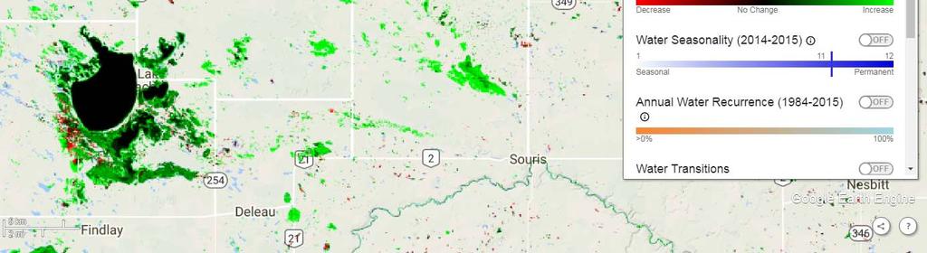
5 Measuring extent In this example, the GSW captured well the 7 hydro-electric reservoirs built after the year 2000 However, all of those created prior to 2000 are not identified. 5
6 Comparison between Global Surface Water Maximum extent and Canadian Hydrographic layer water body (Canvec 1:50 000) Total area in km 2 by Ecozone Canvec GSW occurrence GSW extent 6


7 Measuring change GSW occurrence change intensity identified water decrease (red) in Lac Saint-Pierre, St. Lawrence river The GSW decrease area was compared to the Wetland maps produced by Environment and Climate Change Canada for the same time periods. The wetland maps show low marshes (purple) where GSW has identified water decrease Marshes are periodically or permanently flooded, there are no or few trees and bushes, and in season vegetation can be seen above water Differences between all homologous pairs of months were averaged to create the surface water occurrence change intensity map 7 Source: Jean, Martin, et Guy Létourneau Changements dans les milieux humides du fleuve Saint-Laurent de 1970 à 2002, Environnement Canada, Direction générale des sciences et de la technologie, Monitoring et surveillance de la qualité de l eau au Québec, Rapport technique numéro 511, 302 pages.


8 Transition and Recurrence layers Transition and Recurrence layers are showing the same pattern as the Occurrence Change Intensity although they were not derived the same way. Transition layer indicates that permanent water has become seasonal Recurrence layer indicates that water is low recurrence Based on those results, we recommend to add sampling sites in low marshes to capture the signal associated to water with emergent vegetation. This seasonal effect of vegetation floating on water should be integrated in the model to be mapped as water 8

9 Measuring change 9
10 GSW - Pros 1. The methodology is robust, transparent, very detailed 2. Free and open source: data sources as well as the scripts are available 3. The web mapping application provides: 1. Fast and easy way to visualize the GSW layers 2. Useful information on the monthly water recurrence and water history at pixel level 3. Access to data download 4. Landsat time series from 1984 to 2015 as basemap 4. The Occurrence and Maximum extent layers provide information on water on an annual basis from 1984 to The Water Occurrence layer: can contribute to the improvement of wetland identification (marsh and swamp) could be used as reference for permanent water extent with the identification of the threshold (~75% occurrence) 10
11 GSW - challenges There are important limitations with the results relative to SDG mainly because of spatial and temporal resolution issues. 1. The datasets do not include most streams, many small rivers, wetlands and ponds 2. The time scale is limited - especially when considering the objective is to measure meaningful change. 1. In most cases a thirty year time series is insufficient. 3. Important surface water characteristics we would like to see measured are not measured well changes in frequency, magnitude, timing and overall variability. 4. The results from GSW alone are limited for answering questions related to real change in freshwater ecosystems, and should be considered alongside other important datasets when analysing the data 1. E.g. temperature, precipitation, land cover change 11
12 12
13 Conclusion 1. Use of the Google Earth engine with GSW is a very positive step forward and leveraging this tool will be very beneficial 2. GSW, and other EO global datasets, is a key part of making progress on land, water and ecosystem accounts 3. The most important aspect to emphasize is the need to integrate Google Earth tool and EO data with other tools and other results from other data sources Drawing conclusions from one product alone may not reflect reality meaningfully 13
14 THANK YOU! #StatCan100
WATER SEDIMENTS SHORELINES BIOLOGICAL RESOURCES
 WATER SEDIMENTS SHORELINES BIOLOGICAL RESOURCES USES INVASIVE PLANT SPECIES OF THE ST. LAWRENCE WETLANDS Background Wetland loss in the St. Lawrence River watershed has been declining steadily since the
Data Sources and Methods for the Phosphorus and Nitrogen Levels in the St. Lawrence River Indicator. August 2014
 Data Sources and Methods for the Phosphorus and Nitrogen Levels in the St. Lawrence River Indicator August 2014 Suggested citation for this document: Environment Canada (2014) Canadian Environmental Sustainability
TOWARDS ADAPTATION edition. Caroline Larrivée Vulnerabilities, impacts and adaptation - OURANOS. Synthesis of Climate Change knowledge in Quebec
 TOWARDS ADAPTATION Synthesis of Climate Change knowledge in Quebec 2014 edition Caroline Larrivée Vulnerabilities, impacts and adaptation - OURANOS THE CHANGING CLIMATE : ADAPTATION BY FIRST NATIONS IN
Early Detection and Monitoring of Exotic Invasive Plants in Québec: Building Networks in the Context of Climate Change
 Early Detection and Monitoring of Exotic Invasive Plants in Québec: Building Networks in the Context of Climate Change Isabelle Simard Ministère du Développement durable, de l Environnement, de la Faune
Dynamic Maps of Open Surface Water Bodies in Oklahoma at 30- m Spatial Resolution during
 Dynamic Maps of Open Surface Water Bodies in Oklahoma at 30- m Spatial Resolution during 1984-2014 Xiangming Xiao Center for Spatial Analysis Earth Observation and Modeling Facility Department of Microbiology
Mapping the Boreal zone forest cover and forest cover loss 2000 to 2005
 Matthew Hansen a, Peter Potapov a, Steve Stehman b, Kyle Pittman a, Thomas Loveland c, Mark Carroll d, Charlene DiMiceli d Mapping the Boreal zone forest cover and forest cover loss 2000 to 2005 a - South
Evaluation of Flood Forecasting and Warning Systems in Canada. Peter F. Rasmussen University of Manitoba
 Evaluation of Flood Forecasting and Warning Systems in Canada Peter F. Rasmussen University of Manitoba Being a flood forecaster requires thick skin! 3 4 5 Water Resources Management Divisio Department
Water Accounts with Policy: Analysis and Application of Water Accounting
 Water Accounts with Policy: Analysis and Application of Water Accounting Regional Training Workshop on the System of Environmental-Economic Accounting with a Focus on Water Accounting 26-30 September 2016
St. Lawrence Action Plan Presentation to the Great Lakes and St. Lawrence Cities Initiative. Québec City June 28, 2012
 St. Lawrence Action Plan 2011-2026 Presentation to the Great Lakes and St. Lawrence Cities Initiative Québec City June 28, 2012 1 Canada/Quebec cooperation on the St. Lawrence River PHASE I 1988-1993 Conservation
Canadian Environmental Sustainability Indicators. Water Quantity in Canadian Rivers
 Canadian Environmental Sustainability Indicators Water Quantity in Canadian Rivers Suggested citation for this document: Environment and Climate Change Canada (2016) Canadian Environmental Sustainability
WATER SEDIMENTS SHORELINES BIOLOGICAL RESOURCES USES
 SEDIMENTS SHORELINES BIOLOGICAL RESOURCES USES CHANGES IN WATER LEVEL AND FLOW IN THE ST. LAWRENCE RIVER Background Using a single indicator to characterize the St. Lawrence River s status Figure 1. UNITED
Forest change detection in boreal regions using
 Forest change detection in boreal regions using MODIS data time series Peter Potapov, Matthew C. Hansen Geographic Information Science Center of Excellence, South Dakota State University Data from the
LCEU11 = Rainfed herbaceous cropland Total LCEU08. LCEU09 Summary Table
 Spatial Units: Group Exercise 1: Calculate area of each LCEU and LCEU type LCEU Table LCEU BSU count Area (km 2 ) LCEU01 LCEU02 LCEU01 = Rainfed herbaceous cropland 80 5.0 LCEU02 = Forest tree cover 42
We need to feed 9 billion people by 2050
 Water The big global challenge Re-positioning our advantages for the future Perspectives 2016: Seizing Opportunities Drummondville, QC April 5, 2016 1 We need to feed 9 billion people by 2050 What word
IV. RESULT AND DISCUSSION
 IV. RESULT AND DISCUSSION The result of forest cover change simulation during 4 years was described. This process is done by using the information of land cover condition obtained from satellite imagery
EIC Climate Change Technology Conference 2015
 St. Lawrence River Forecasted Drying Effects Water Level and Flow Control Project CCTC 2015 Paper Number 1570115351 F Pierre Gingras Hydro-Québec (retired) Canadian Academy of Engineers, Canadian Society
Measuring Ecosystem Services in Canada
 Measuring Ecosystem Services in Canada Regional Training Workshop on the System of Environmental-Economic Accounting with a Focus on Water Accounting September 26-30, 2016, Putrajaya, Malaysia François
What factors affect life in aquatic ecosystems?
 Aquatic Ecosystems: Notes Outline Today s Objective: Students will explain that different types of organisms exist within aquatic systems due to chemistry, geography, light, depth, salinity, and/or temperature.
Suitability of Global Forest Change data to report forest cover estimates at national level in Gabon
 Systèmes d Information à Référence Spatiale Suitability of Global Forest Change data to report forest cover estimates at national level in Gabon Expert workshop on using global datasets for national REDD+
Polybrominated diphenyl ethers in the suspended matter and sediments of the St. Lawrence River
 a Polybrominated diphenyl ethers in the suspended matter and sediments of the St. Lawrence River Background Polybrominated diphenyl ethers (PBDEs) have been used as flame retardants since the 196s, in
Initial Application of a Landscape Evolution Model to a Louisiana Wetland
 Initial Application of a Landscape Evolution Model to a Louisiana Wetland by Carl F. Cerco PURPOSE: Corps planning projects encompass a wide variety of restoration goals. These include wetland restoration,
Economic Study on the Impacts of Low Water Levels on the Saint-Laurent River and Adaptation Options
 Economic Study on the Impacts of Low Water Levels on the Saint-Laurent River and Adaptation Options Adaptation Canada April 13th 2016 Ottawa Nicolas Audet Claude Desjarlais, Caroline Larrivée & al. 1 Context
Integrating Climate Change Considerations into Environmental Assessments of Hydro-electric Power Projects in Eastern and Northern Canada
 Integrating Climate Change Considerations into Environmental Assessments of Hydro-electric Power Projects in Eastern and Northern Canada Bhawan Singh, Sébastien Gagnon, Nicklaus Davey, Pierre André, Luc
EO opportunities and challenges for achieving SDG 6.6
 EO opportunities and challenges for achieving SDG 6.6 Marc Paganini, European Space Agency (ESA) Sharing experiences on indicator 6.6.1 on freshwater related ecosystems, and exploring opportunities for
Manitoba s Submission Guidelines for Peatland Recovery Plans
 Manitoba s Submission Guidelines for Peatland Recovery Plans Peatland Management Guidebook Forestry and Peatlands Branch Manitoba Sustainable Development First Published: September 2017 Review by: 2022
INFRASTRUCTURE SPOTLIGHT: THE GREAT LAKES AND ST. LAWRENCE WATERSHEDS
 July 2012 INFRASTRUCTURE SPOTLIGHT: THE GREAT LAKES AND ST. LAWRENCE WATERSHEDS The Great Lakes and St. Lawrence River Basin is one of the largest freshwater systems in the world. Covering more than 1.6
IPCC Les îles bleues dans un océan vert: Les systèmes aquatiques boréaux et leur rôle dans le bilan régional de C
 IPCC 2007 Les îles bleues dans un océan vert: Les systèmes aquatiques boréaux et leur rôle dans le bilan régional de C Paul del Giorgio et Y. T. Prairie Université du Québec à Montréal Why aren t surface
Earth observations for water resource management: Current practice and examples
 Earth observations for water resource management: Current practice and examples NEW OPPORTUNITIES IN SATELLITE AND AIRBORNE REMOTE SENSING: Hydrological and Environmental Applications DTU Environment Lyngby
Think About It (not on notes)
") Aquatic Ecosystems Think About It (not on notes) We call our planet Earth, yet nearly three-fourths of Earth s surface is covered with water. Despite the vital roles aquatic ecosystems play in the biosphere,
Aquatic Ecosystems Think About It (not on notes) We call our planet Earth, yet nearly three-fourths of Earth s surface is covered with water. Despite the vital roles aquatic ecosystems play in the biosphere,
Ecological Integrity Monitoring Program
 Ecological Integrity Monitoring Program Patrick Graillon Conservation coordinator Quebec s National parks mission Park means a national park whose primary purpose is to ensure the conservation and permanent
Earth Observation in support for project identification/preparation
 Asian Water Forum Oct. 5th 2018 Asian Development Bank Manila, Philippines Earth Observation in support for project identification/preparation Christian Tottrup, DHI GRAS EO4SD -> Background Water plays
Lawrence Friedl USA / NASA
 Geospatial Information and Earth Observations: Supporting Official Statistics in Monitoring the SDGs UNSC STATISTICAL-GEOSPATIAL INTEGRATION FORUM United Nations 7 March 2016 Session III. Geospatial and
Drought Indices in North America. Richard R. Heim Jr.
 Drought Indices in North America Richard R. Heim Jr. NOAA/NESDIS/ Asheville, North Carolina, USA Inter-Regional Workshop on Indices and Early Warning Systems for Drought WMO/NDMC/NOAA/UNCCD/USDA Lincoln,
Naomi Feger SF Bay RWQCB January 6, 2017
 Harmful Algal Blooms North Bay Watershed Association January Meeting Naomi Feger SF Bay RWQCB January 6, 2017 Why are Harmful Algal Blooms (HABs) a Problem in California HABs create significant water quality
TODAY S GOALS. Intro to water and environmental issues
 TODAY S GOALS Intro to water and environmental issues Ecosystems Biomes Watershed Global water use and budgeting At the end of the class, we should be able to understand the complexity of water resources
Directly abuts? (Y/N) Size (in acres) Directly abuts? (Y/N) Size (in acres)
 Size (in acres) Directly abuts? (Y/N) Size (in acres)") For each wetland, specify the following: Directly abuts? (Y/N) Size (in acres) Directly abuts? (Y/N) Size (in acres) Summarize overall biological, chemical and physical functions being performed:. C. SIGNIFICANT
For each wetland, specify the following: Directly abuts? (Y/N) Size (in acres) Directly abuts? (Y/N) Size (in acres) Summarize overall biological, chemical and physical functions being performed:. C. SIGNIFICANT
Assessment of inundation extent and quality in the Atchafalaya Basin Floodway System (ABFS) from using Landsat Imagery
 from using Landsat Imagery") Assessment of inundation extent and quality in the Atchafalaya Basin Floodway System (ABFS) from 1983-2008 using Landsat Imagery Yvonne Allen - U.S. Geological Survey, Nat l. Wetlands Research Center Glenn
Assessment of inundation extent and quality in the Atchafalaya Basin Floodway System (ABFS) from 1983-2008 using Landsat Imagery Yvonne Allen - U.S. Geological Survey, Nat l. Wetlands Research Center Glenn
Ecosystem accounting at the European Environment Agency: a summary of progress 1
 Ecosystem accounting at the European Environment Agency: a summary of progress 1 Glenn-Marie Lange, The Earth Institute at Columbia University Jean-Louis Weber, European Environment Agency 25 October 2006
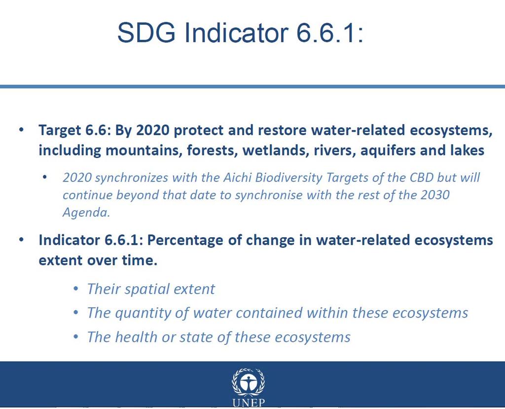
Water targets and indicators of the the SDGs Peter Koefoed Bjornsen Director of UNEP-DHI Partnership Centre on Water and Environment
 UNEP-DHI Water Webinar series Approaching the SDGs through Innovation in Water Management Water targets and indicators of the the SDGs Peter Koefoed Bjornsen Director of UNEP-DHI Partnership Centre on
Hydrosphere. 71% of the Earth s surface is water! The layer of water on the Earth: Includes liquid and solid forms
 Hydrosphere Hydrosphere 71% of the Earth s surface is water! The layer of water on the Earth: Includes liquid and solid forms Saltwater Freshwater Ice (Cryosphere; freshwater) Gases technically belong
Manitoba s Submission Guidelines for Peatland Recovery Plans
 Manitoba s Submission Guidelines for Peatland Recovery Plans Peatland Management Guidebook Forestry and Peatlands Branch Manitoba Sustainable Development First Published: September 2017 Review by: 2022
Great Lakes-St. Lawrence River Water Resources Regional Body RESOLUTION NO
 Great Lakes-St. Lawrence River Water Resources Regional Body RESOLUTION NO. 2015-10 ADOPTING DECLARATION OF FINDING For the Water Management Program Review and Water Conservation and Efficiency Program
Integrating and Visualizing Earth Observation Data for the SDGs Mike Gill
 7 th Meeting of the Interagency and Expert Group on Sustainable Development Goal Indicators Vienna, Austria 12 April, 2018 Integrating and Visualizing Earth Observation Data for the SDGs Mike Gill GEO
Study of Hydrology based on Climate Changes Simulation Using SWAT Model At Jatiluhur Reservoir Catchment Area
 Study of Hydrology based on Climate Changes Simulation Using SWAT Model At Jatiluhur Reservoir Catchment Area Budi Darmawan Supatmanto 1, Sri Malahayati Yusuf 2, Florentinus Heru Widodo 1, Tri Handoko
ICELANDIC RIVER / WASHOW BAY CREEK INTEGRATED WATERSHED MANAGEMENT PLAN STATE OF THE WATERSHED REPORT CONTRIBUTION SURFACE WATER HYDROLOGY REPORT
 ICELANDIC RIVER / WASHOW BAY CREEK INTEGRATED WATERSHED MANAGEMENT PLAN STATE OF THE WATERSHED REPORT CONTRIBUTION SURFACE WATER HYDROLOGY REPORT Disclaimer: The hydrologic conditions presented in this
Western North America Mercury Synthesis (WNAMS)
") Western North America Mercury Synthesis (WNAMS) A Multi-disciplinary, tri-national assessment of the climate, landscape, and land use controls on mercury risk to ecological and human health across western
Western North America Mercury Synthesis (WNAMS) A Multi-disciplinary, tri-national assessment of the climate, landscape, and land use controls on mercury risk to ecological and human health across western
GLOBAL SYMPOSIUM ON SOIL ORGANIC CARBON, Rome, Italy, March 2017
 GLOBAL SYMPOSIUM ON SOIL ORGANIC CARBON, Rome, Italy, 21-23 March 2017 Quantifying terrestrial ecosystem carbon stocks for future GHG mitigation, sustainable land-use planning and adaptation to climate
Components, sub-components and statistical topics of the FDES 2013
 Environment Statistics Section, United Nations Statistics Division Components, sub-components and statistical topics of the FDES 2013 Component 1: Environmental conditions and quality 6. Environment Protection,
Surface Water and Ocean Topography (SWOT) Mission. Lake Vector Products Tamlin Pavelsky and Jean-Francois Cretaux
 Mission. Lake Vector Products Tamlin Pavelsky and Jean-Francois Cretaux") Surface Water and Ocean Topography (SWOT) Mission Lake Vector Products Tamlin Pavelsky and Jean-Francois Cretaux SWOT Science Definition Team Meeting, July 7-9, 2015 Proposed Vector Data Products Pass-based
Surface Water and Ocean Topography (SWOT) Mission Lake Vector Products Tamlin Pavelsky and Jean-Francois Cretaux SWOT Science Definition Team Meeting, July 7-9, 2015 Proposed Vector Data Products Pass-based
Aqueduct 2.0 Project Water Indicators
 Aqueduct 2.0 Project Water Indicators The Aqueduct 2.0 is a project of the World Resources Institute, which was the source of the indicators presented here (Gassert et al., 2013). Sustainability Goals:
Action Plan
 2018-2023 Action Plan COORDINATION AND DRAFTING This publication was written by the Direction générale des politiques de l eau of Ministère du Développement durable, de l Environnement et de la Lutte contre
Wetland Stewardship in NWT A Trail Map
 Wetland Stewardship in NWT A Trail Map Ducks Unlimited Canada has led wetland conservation efforts in Canada for the past 77 years science-based approach completed over 9500 wetland conservation projects,
The GEO Global Agricultural Monitoring (GEOGLAM) Initiative
 Initiative") The GEO Global Agricultural Monitoring (GEOGLAM) Initiative Chris Justice GEOGLAM Global Co-Lead The Center for Agricultural Monitoring Research, Department of Geographical Sciences, GEOGLAM Launched by
The GEO Global Agricultural Monitoring (GEOGLAM) Initiative Chris Justice GEOGLAM Global Co-Lead The Center for Agricultural Monitoring Research, Department of Geographical Sciences, GEOGLAM Launched by
HYDRO-ECOLOGICAL MONITORING OF COASTAL MARSH USING HIGH TEMPORAL RESOLUTION SENTINEL-1 TIME SERIE
 HYDRO-ECOLOGICAL MONITORING OF COASTAL MARSH USING HIGH TEMPORAL RESOLUTION SENTINEL-1 TIME SERIE C.Cazals (a), S. Rapinel (b,c), P-L. Frison(a), A. Bonis(b), Mercier, Mallet, Corgne, J-P. Rudant(a) (a)
Elk Valley Water Quality Plan Technical Advisory Committee Meeting #5 Notes April 2-4, 2014 Cranbrook, BC
 Meeting Objectives Provide an update on the (EVWQP or Plan ). Review and discuss the action items from Technical Advisory Committee (TAC) Meetings 3 & 4. Review and discuss the TAC technical advice received
The impact of Gouin Reservoir management on the ecohydrological drought characteristics of streamflow in the Saint-Maurice River (Quebec, Canada)
") Sustainable Development, Vol. 1 347 The impact of Gouin Reservoir management on the ecohydrological drought characteristics of streamflow in the Saint-Maurice River (Quebec, Canada) R. Landry & A. A. Assani
Sustainable Development, Vol. 1 347 The impact of Gouin Reservoir management on the ecohydrological drought characteristics of streamflow in the Saint-Maurice River (Quebec, Canada) R. Landry & A. A. Assani
Wetlands. Discover an ecosystem important for life
 Wetlands Discover an ecosystem important for life A PLATFORM TO CONSERVE THE WORLD S WETLANDS The Ramsar Convention on Wetlands is the intergovernmental treaty that provides the framework for the conservation
Réduction de la biomasse en forêt boréale de l Est du Canada sous l effet des changements climatiques
 Journée Modèle Québec Jeud er novembre 208 Réduction de la biomasse en forêt boréale de l Est du Canada sous l effet des changements climatiques Emeline Chaste PhD in Environmental Science University of
Draft. Environmental Assessment Guidelines (including the Scope of the Environmental Assessment)
") Draft the Scope of the Environmental Assessment) March 2012 Page left intentionally blank I II Page left intentionally blank III TABLE OF CONTENTS 1 INTRODUCTION... 1 1.1 PROJECT BACKGROUND... 1 1.2 APPLICATION
Draft the Scope of the Environmental Assessment) March 2012 Page left intentionally blank I II Page left intentionally blank III TABLE OF CONTENTS 1 INTRODUCTION... 1 1.1 PROJECT BACKGROUND... 1 1.2 APPLICATION
Pooling the data into intersectoral governance for incountry
 Using Big Data and Earth Observations for SDG 6 monitoring World Water Week 2018 August 29 Stockholm, Sweden Pooling the data into intersectoral governance for incountry implementation Christian Tottrup,
Natural Capital Protocol System of Environmental Economic Accounting Toolkit
 Natural Capital Protocol System of Environmental Economic Accounting Toolkit Discussion paper September 2017 Institute for Development of Environmental-Economic Accounting 219 Rathmines Rd, Fairfield,
Witness Statement Re: Proposed Belledune Project by Bennett Environmental Inc. ADDENDUM: L.D. Pengelly,
 Witness Statement Re: Proposed Belledune Project by Bennett Environmental Inc. ADDENDUM: L.D. Pengelly, 2004-11-25 Recent Action by the Minister of the Environment for the Province of Québec On September
CWS Landscape Conservation Guidance and Planning. Graham Bryan CWS-ON September 16 th, 2016 Bracebridge
 CWS Landscape Conservation Guidance and Planning Graham Bryan CWS-ON September 16 th, 2016 Bracebridge Canadian Wildlife Service Part of Environment & Climate Change Canada CWS is responsible for wildlife
1.6 Influence of Human Activities and Land use Changes on Hydrologic Cycle
 1.6 Influence of Human Activities and Land use Changes on Hydrologic Cycle Watersheds are subjected to many types of changes, major or minor, for various reasons. Some of these are natural changes and
Big Data in Water: Opportunities and Challenges for Machine Learning
 2018 Water Resources Assembly and Research Symposium Headwaters Lecture Big Data in Water: Opportunities and Challenges for Machine Learning Vipin Kumar Department of Computer Science and Engineering University
Future fire regime in Canada, potential effects on forests, forest sector and forest communities
 1 Future fire regime in Canada, potential effects on forests, forest sector and forest communities by Sylvie Gauthier, Yan Boulanger et al. sylvie.gauthier2@canada.ca Adaptation 2016 2 Fire is highly variable
Presentation of the Nunavik Tundra Project (ArcticNet/Ouranos) Work team: Pascale Ropars, Nicolas Casajus and Dominique Berteaux
 Work team: Pascale Ropars, Nicolas Casajus and Dominique Berteaux") Presentation of the Nunavik Tundra Project (ArcticNet/Ouranos) Work team: Pascale Ropars, Nicolas Casajus and Dominique Berteaux Although change is not new to Nunavik, the last few decades have been marked
Presentation of the Nunavik Tundra Project (ArcticNet/Ouranos) Work team: Pascale Ropars, Nicolas Casajus and Dominique Berteaux Although change is not new to Nunavik, the last few decades have been marked
Supplementary Information
 Supplementary Information 585 590 595 600 605 The 46 sites that were used in this study represent gradients in climate, tree cover, and disturbance frequency (Figure 1; Table S3). The sites fall within
Marine Terminal Project on the North Shore of the Saguenay. Environmental Assessment Report
 Marine Terminal Project on the North Shore of the Saguenay Environmental Assessment Report October 2018 Her Majesty the Queen in Right of Canada, represented by the Minister of the Environment, October,
Using Hansen's Global Forest Cover Change Datasets to Assess Forest Loss in Terrestrial Protected Areas
 Using Hansen's Global Forest Cover Change Datasets to Assess Forest Loss in Terrestrial Protected Areas A Case Study of the Philippines Armando Apan (Prof.), L.A. Suarez, Tek Maraseni & Allan Castillo
RSVL (Network of Volunteer Lake Monitors)
") RSVL (Network of Volunteer Lake Monitors) 1 Photo : ABVLACS Photo : ABVLACS Photo : CRE Laurentides Photo : ABVLACS Notes: This presentation was translated from the original French version by the Blue
RSVL (Network of Volunteer Lake Monitors) 1 Photo : ABVLACS Photo : ABVLACS Photo : CRE Laurentides Photo : ABVLACS Notes: This presentation was translated from the original French version by the Blue
Prioritizing Local Action. Strengthening the Resilience of the Taunton River Watershed
 Prioritizing Local Action Strengthening the Resilience of the Taunton River Watershed No Really, We re Here to Help 6/12/14 Healthy and Resilient Taunton Watershed Project EPA s Healthy Watershed Program
An example of user engagement
 Title An example of user engagement from the PoC in Water Management: SWICCA Berit Arheimer, SMHI An example of user engagement: P o C WATER Proof-of-Concept in C3S for Sectorial Information Services Experience
BIOMES. Living World
 BIOMES Living World Biomes Biomes are large regions of the world with distinctive climate, wildlife and vegetation. They are divided by terrestrial (land) or aquatic biomes. Terrestrial Biomes Terrestrial
Ecological Considerations in Setting MFLs and Lake Regulation Targets for the Ocklawaha Chain of Lakes
 Ecological Considerations in Setting MFLs and Lake Regulation Targets for the Ocklawaha Chain of Lakes Rolland Fulton, Ph.D. Environmental Scientist VI Bureau of Environmental Sciences St. Johns River
Lake level trends in central Alberta Cristina Buendia, PhD North Saskatchewan Watershed Alliance Flowing Waters, October 2017
 Lake level trends in central Alberta Cristina Buendia, PhD North Saskatchewan Watershed Alliance Flowing Waters, October 2017 Isle Lake Breda Muldoon- Beaverhill lake. Lac Ste Anne... Lakes are important
Remote Sensing Uses in Agriculture at NASS
 Remote Sensing Uses in Agriculture at NASS United States Department of Agriculture (USDA) National Agriculture Statistics Service (NASS) Research and Development Division Geospatial Information Branch
Final Environmental Assessment Guidelines (including the Scope of the Environmental Assessment)
") Final Environmental Assessment Guidelines (including the Scope of the Environmental Assessment) July 2012 RDIMS: 7401089 Page left intentionally blank I RDIMS: 7401089 II RDIMS: 7401089 Page left intentionally
Final Environmental Assessment Guidelines (including the Scope of the Environmental Assessment) July 2012 RDIMS: 7401089 Page left intentionally blank I RDIMS: 7401089 II RDIMS: 7401089 Page left intentionally
ENVIRONMENTAL ASPECTS OF INTEGRATED FLOOD MANAGEMENT
 ENVIRONMENTAL ASPECTS OF INTEGRATED FLOOD MANAGEMENT Photo by: Liang Changsheng WMO WMO/GWP ASSOCIATED PROGRAMME ON FLOOD MANAGEMENT (APFM) World Meteorological Organization 1 Flood Plains Positive aspects:
CBI/WCS Woodland Caribou Expert Workshop Summary
 CBI/WCS Woodland Caribou Expert Workshop Summary A workshop organized by the Canadian Boreal Initiative and Wildlife Conservation Society was held February 28 and March 1, 2006 at the University of Ottawa
Fish Habitat Management System for Yukon Placer Mining. Adaptive Management Framework
 Fish Habitat Management System for Yukon Placer Mining Adaptive Management Framework Prepared by The Yukon Placer Adaptive Management Working Group November 2008 1.0 ADAPTIVE MANAGEMENT FRAMEWORK 1.1 Introduction
Climate Change & The Water Sector
 & The Water Sector Copernicus for Climate Adaptation and Mitigation Copernicus EU Copernicus EU Copernicus EU www.copernicus.eu WHY IS COPERNICUS NEEDED IN WATER SECTOR? Climate Climate and the water cycle
How to model water quality using SWAT model in the Amazon catchment?
 6 ème réunion scientifique du SO HYBAM 26-3 Octobre- Cuzco- Pérou How to model water quality using SWAT model in the Amazon catchment? SAUVAGE, S., SANCHEZ-PEREZ J.M., With the collaboration of SANTINI
Using multi-temporal ALOS PALSAR to investigate flood dynamics in semi-arid wetlands: Murray Darling Basin, Australia.
 Using multi-temporal ALOS PALSAR to investigate flood dynamics in semi-arid wetlands: Murray Darling Basin, Australia. Rachel Melrose, Anthony Milne Horizon Geoscience Consulting and University of New
River Talk Patterns. Student Copy Page PART I (1 of 1) 3. Human nervous system. Waters and drainage patterns. Road system.
 3. Human nervous system. Waters and drainage patterns. Road system.") River Talk Patterns Student Copy Page PART I (1 of 1) 3 Human nervous system photo credit: Hemera Thinkstock Photos Waters and drainage patterns photo credit: Comstock Getty Images Road system photo credit:
River Talk Patterns Student Copy Page PART I (1 of 1) 3 Human nervous system photo credit: Hemera Thinkstock Photos Waters and drainage patterns photo credit: Comstock Getty Images Road system photo credit:
Monitoring Condition of Savanna Riparian Zones in North Australia
 Monitoring Condition of Savanna Riparian Zones in North Australia Centre for Remote Sensing and Spatial Information Science Kasper Johansen Centre for Remote Sensing and Spatial Information Science School
Inventory, assessment and monitoring of wetlands: An integrated approach
 Inventory, assessment and monitoring of wetlands: An integrated approach Parikshit Gautam Director Freshwater & Wetlands Programme WWF - India Email: pgautam@wwfindia.net Taal 2007-12th World Lake Conference,
9 th Grade Lesson 82. Cornell Note Paper Student White Boards.
 9 th Grade Lesson 82 Cornell Note Paper Student White Boards. Lesson 82 9 th Grade Mr. Petersen Bonneville Junior High Self Starter * 20 Points * 1/31/2015 * Lesson 82 Do not shorten or abbreviate this
Mekong Wetland Assets
 1 Basin-wide Climate Change Impact and Vulnerability Assessment for Wetlands of the LMB for Adaptation Planning 2nd Regional Expert Advisory Workshop, Vientiane 11-12 July 2011 Mekong Wetland Assets Prepared
Aussi disponible en français sous le titre: ENLARGED - MAP 2
 This publication can be viewed on the St. Lawrence Plan Web Site: www.planstlautrent.qc.ca Coordination Office of St. Lawrence Plan 1141 Route de l Église P.O. Box 10100 Québec, Québec G1V 4H5 Telephone:
Interactions between wetlands CH4 emissions and climate at global scale
 Interactions between wetlands CH4 and climate at global scale Bruno Ringeval - Laboratoire de Sciences du Climat et de l'environnement (LSCE), Gif-sur-Yvette - University of Bristol, UK and University
The effect of reservoir networks on drought propagation
 European Water 60: 287-292, 2017. 2017 E.W. Publications The effect of reservoir networks on drought propagation P.R. van Oel 1*, E.S.P.R. Martins 2 and A.C. Costa 3 1 Water Resources Management group,
Environmental stats: Methods & developments. Chris Jager
 Environmental stats: Methods & developments Chris Jager Countries by population density (2006) CURAÇAO ENVIRONMENTAL STATISTICS COMPENDIUM 2015 3 Curaçao, Dec. 2016 Core set environmental statistics 6.
Adaptive strategies to Mitigate the Impacts of Climate Change on European Freshwater Ecosystems
 SEVENTH FRAMEWORK PROGRAMME THEME 6 Environment (including Climate Change) Adaptive strategies to Mitigate the Impacts of Climate Change on European Freshwater Ecosystems Martin Kernan Environmental Change
Encouraging Market Transformation through Collaboration on Energy Efficiency Standards
 Encouraging Market Transformation through Collaboration on Energy Efficiency Standards 208 209 Federal-Provincial-Territorial Action Plans Energy and Mines Ministers Conference Iqaluit, Nunavut August
THE EMERGENCE OF A GREEN ECONOMY IN THE CONTEXT OF THE SUSTAINABLE DEVELOPMENT OF QUÉBEC
 By Mrs. Claire Deronzier, Déléguée générale du à Tokyo Kyoto, May 22 2015 THE EMERGENCE OF A GREEN ECONOMY IN THE CONTEXT OF THE SUSTAINABLE DEVELOPMENT OF QUÉBEC Presentation plan at a glance Sustainable
Hydrosphere: Water Distribution
 Hydrosphere: Water Distribution 1.Think About It Why is it that the water in your bottle could have been drunk by George Washington? 2. The Hydrosphere: An Overview The hydrosphere is ALL the water on/in/over
Lecture 15: Flood Mitigation and Forecast Modeling
 Lecture 15: Flood Mitigation and Forecast Modeling Key Questions 1. What is a 100-year flood inundation map? 2. What is a levee and a setback levee? 3. How are land acquisition, insurance, emergency response
Introduction to SEEA Water Accounting
 UNSD Introduction to SEEA Water Accounting Cor Graveland 09-11-2016 Outline Introduction What are water accounts Why account for water Water accounts schematics Accounting tables 3 The SEEA-Water is a
The Impact of Climate Change on Surface and Groundwater Resources and their Management. I Concepts, Observations, Modeling.
 The Impact of Climate Change on Surface and Groundwater Resources and their Management I Concepts, Observations, Modeling Manfred Koch Department of Geohydraulics and Engineering Hydrology, University