Operational Monitoring of Alteration in Regional Forest Cover Using Multitemporal Remote Sensing Data ( )
|
|
|
- Elfreda Bell
- 5 years ago
- Views:
Transcription


")


1 Operational Monitoring of Alteration in Regional Forest Cover Using Multitemporal Remote Sensing Data ( ) Janet Franklin Doug Stow John Rogan Lisa Levien Chris Fischer Curtis Woodcock Consultant: Xueqiao Huang
2 General Objectives of the Study This research will apply remote sensing techniques to map changes in forest cover in California to examine LCLUC over several 5- year time periods The scope of this research will be the testing and improvement of an operational FS-CDF forest change monitoring program
3 Specific Objectives of the Study Research Objective 1 Establish an operational forest cover change monitoring program based on the following project efficiency indicators: - Change-map accuracy assessment - Flexibility of implementation - Interpretability of methods and results - Consistency across phenologically diverse areas
4 Specific Objectives of the Study Research Objective 1: Related research questions 1. Which change detection techniques produce the most accurate, interpretable maps of forest cover change? 2. How do the existing FS-CDF program methods compare to those generated by state-of-the-art techniques? 3. How do results differ between southwest and northeast California study sites?
5 Specific Objectives of the Study Research Objective 2 Implement the forest monitoring program established in Objective 1 to analyze the extant data sets (spanning )
6 3. How are changes in forest cover associated with mapped lifeform and species categories in the region? Specific Objectives of the Study Research Objective 2: Related research questions for the following time periods , , How is forest cover change manifested in terms of a) geographical extent, b) cause, c) rate? 2. How does forest cover change affect landscape spatial patterns (e.g., habitat fragmentation)?
7 Research Relevance LCLUC Disturbance Monitoring Logging * Selective * Clearcut Fire * Wildfire * Prescribed Pest Infestation Regrowth * Natural * Replanting Urban Growth


8


9

10


11


12


13 Existing FS-CDF Program Methods *USDA Forest Service - California Department of Forestry and Fire Protection Change Monitoring Program
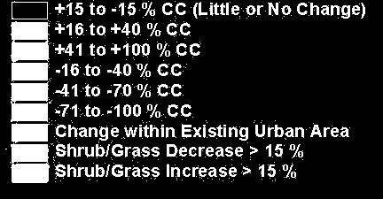
14 Existing FS-CDF Program Methods Change Data with accuracy assessment - 70 to - 100% CC - 41 to - 70% CC - 16 to - 40% CC + 15 to - 15% CC + 16 to + 40% CC + 41 to + 100% CC Shrub/Grass Decrease > 15% Shrub/Grass Increase > 15% Change w/in Existing Urban Area Cloud or Cloud Shadow Cause Database Mortality Wildfire Harvest Regeneration Fuel Break Thinning Development Conversion Other Unknown
15 Existing FS-CDF Program Methods Expert Program Methods - Phase I Image Processing TM T1 TM T2 MKT Transform BGW Pixel-level Change Image

16 Existing FS-CDF Program Methods Expert Program Methods - Phase II Classify and Label Change Label Change Unsupervised Classification Aerial Photos GIS Layers Other Imagery Canopy Cover Change Map


17 Study Sites Lassen National Forest Plumas National Forest Sacramento Angeles National Forest San Bernardino National Forest Cleveland National Forest
18 Current Methods The research proposed presents a comprehensive, multitemporal, multistage forest cover change monitoring strategy 1. Data sets: - Landsat 5 and 7, Aerial Photos, ADAR, IKONOS - Fire Perimeters, Pest Records, Logging Records - Canopy cover measurements (densitometer and high spatial resolution resolution multispectral data)


19 Canopy Cover Measurements IKONOS Data (4 meter)
20 Current Methods 2. Radiometric Normalization 3. Image Enhancement Techniques - Spectral Mixture Analysis - Change Vector Analysis - Spatial Indices (Texture-Context) 4. Classification - Classification Tree - ANN-Fuzzy ARTMAP 5. Evaluation - Error Matrix, Fuzzy Accuracy, Spatial Accuracy
21 Scientific Results Atmospheric Correction /Normalization Image Change Enhancement Image Classification Accuracy Assessment
22 Atmospheric Correction/ Normalization Space-varying haze correction (Carlotto, 1999) Spectral measurement space consists of two subspaces Subspace 1 = bands affected by scattering (visible) Subspace 2 = bands less affected by scattering (infrared) Correspondence between the two subspaces used to predict Subspace 1 as a function of Subspace 2 on a per-pixel basis


23 Spatially Varying Haze Correction Uncorrected Corrected Landsat 7 ETM Band 1 Landsat 7 ETM Band 2 Landsat 7 ETM Band 3
24 Atmospheric Correction/ Normalization Results (ANOVA between pre vs. post correction) The algorithm removes the effects of smoke plumes without altering the pixel values of areas unaffected by haze Areas that have changed between dates are readily detected, post-normalization Reliable and easily implemented across varying topography and landcover types
25 Image Enhancement Comparisons Study attempted to Examine the potential of Multitemporal Spectral Mixture Analysis (MSMA) to map changes in forest cover over large areas Compare the MSMA approach to that of MKT Evaluation based on Classification accuracy Ease of use, flexibility of implementation, operational issues etc.
26 Image Enhancement Comparisons Results MSMA produces four change fractions (i.e., shade, green veg., non-photosynthetic veg., and soil) using reference endmembers MSMA fractions are biophysically robust and interpretable MSMA classification using approach was repeatedly 5-10% more accurate than MKT in all investigations However, MKT produces equally reliable features and is more easily implemented
27 Image Classification Comparisons I Study attempted to Examine the potential of a C4.5-based classification tree Machine Learning Classifier (MLC) Compare the utility of the MLC approach to S- plus Evaluation of MLC vs. S-plus based on Classification accuracy Ease of use, flexibility of implementation, operational issues etc.
28 Classification Approach Classifier Assess Classification Correct measured canopy BGW signatures covertype fire mask elevation aspect slope Not Correct Refine Training Data Final Change Map with Canopy Classes

29 Machine Learning Classifier Useful interface with Erdas Rules easily classified Deals with categorical data well Iterative tree growing negates the need for pruning Tendency to create large trees Rules determine that unclassified pixels receive value of largest category in the map Thematic output has been unreliable
30 S-plus Classification Tree Approach No existing interface with Erdas Rules easily classified Difficulty with categorical data with layers having more than 31 classes Trees are manageable, through pruning, providing more control Thematic output is generally reliable
 Overall")
31 S-Plus classification accuracy (Southern California) Overall Accuracy = 88%
 Overall")
32 MLC classification accuracy (Southern California) Overall Accuracy = 86%

33 Order of variables used at each split: S = S-plus, M = MLC Variables Fire S M Aspect Slope M M Elevation Vegetation S M S M MKT_1 S M MKT_2 S M MKT_3 S M MKT_4 MKT_5 M M MKT_6 S M
34 Image Classification Comparisons I Results Both approaches produce canopy cover change maps of high classification accuracy (i.e., overall accuracy and individual class accuracies) Due to large trees produced by C4.5, rules can tend to be less generalizable to larger areas In general, S-plus classifies better at the pixel level and at the site level S-plus can be easily implemented
35 Image Classification Comparisons II Study attempted to Examine the potential of Fuzzy ARTMAP Compare the utility of the ARTMAP approach to S-plus Evaluation of ARTMAP vs. S-plus based on Classification accuracy Ease of use, flexibility of implementation, operational issues etc.


")
36 ARTMAP classification accuracy (Southern California) (test site) Overall Accuracy = 98.7%
37 Accuracy Assessment Approaches Conventional error matrix (non-spatial) Fuzzy accuracy (non-spatial) Using misclassification probabilities (per class) to map spatial variation in error


38 Forest Canopy Cover Change Map San Diego County
39 Change Map Error Matrix Reference Class Sites Input Layers: Phase I change Covertype Cause (fire) Classified As Seasonality Sites Class Description Producer's Accuracy User's Accuracy Class Class Class 1-71 to -100% CC 1 = 7 / 7 = 100% Tree Decr 1 = 7 / 7 = 100% Tree Decr 2-41 to -70% CC 2 = 12 / 12 = 100% 96% 2 = 12 / 12 = 100% 92% 3-16 to -40% CC 3 = 5 / 6 = 83% 3 = 5 / 7 = 71% to -15% CC (Little or No Change) 4 = 148 / 159 = 93% / 162 = 91% to +40% CC 5 = 4 / 6 = 67% Tree Incr 5 = 4 / 4 = 100% Tree Incr to +100% CC 6 = 1 / 1 = 100% 71% 6 = 1 / 1 = 100% 100% 7 Shrub/Grass Decrease > 15% 7 = 15 / 18 = 83% 7 = 15 / 20 = 75% 8 Shrub/Grass Increase > 15% 8 = 15 / 22 = 68% 8 = 15 / 17 = 88% 9 Change within Existing Developed Area 9 = 25 / 28 = 89% 9 = 25 / 29 = 86% 15 Cloud or Cloud Shadow 15 = 1 / 1 = 100% 15 = 1 / 1 = 100% (inverse is error of omission) (inverse is error of commission) Training sites: % Overall Accuracy = 89.2% AA sites: % TOTAL sites: 395


40 Estimated Accuracy Map Low Accuracy High Accuracy
41 Expert FS-CDF Approach Atmospheric Normalization Summary Current SDSU Approach Haze Correction Image Enhancement Unsupervised Classification Map Editing/ Masking Months of Work Involved Atmospheric Normalization Image Enhancement Supervised Classification Accuracy Assessment Accuracy Assessment
 Image Classification Compare S-plus Classification Tree approach to Fuzzy ARTMAP Accuracy Assessment (spatial) Examine the use of confidence images in conveying")
42 Future Steps Atmospheric Correction /Normalization Compare DOS approaches with ATCOR3 Image Change Enhancement Examine the utility of Change Vector Analysis (CVA) vs. MKT (i.e, phenological increases) Image Classification Compare S-plus Classification Tree approach to Fuzzy ARTMAP Accuracy Assessment (spatial) Examine the use of confidence images in conveying accuracy assessment
43 Most Significant Results/ Findings Spatially varying haze-correction algorithm should prove useful in fire-related studies Multitemporal Kauth Thomas is robust in enhancing change over large areas Classification Tree and or/ Fuzzy ARTMAP classifiers are better at mapping LCLUC because of their non-parametric nature, ability to incorporate non-image data and their generalizability Fuzzy approaches to mapping LCLUC and spatial accuracy mapping should be explored further
44 Work Schedule TASKS AND PROJECT YEAR / 2001 PROJECT YEAR / 2002 PROJECT YEAR / 2003 DELIVERAB LES Q1 Q2 Q3 Q4 Q1 Q2 Q3 Q4 Q1 Q2 Q3 Q4 These general task categories Program Prototyping and Testing Program Implementation For and Data For all Data appl y to Phases Ι and ΙΙ 1. Acquire Image Data Acquire Collateral Data Image Preprocessing Field Data Collection Enhancement and Classification Meetings Presentations * * * * * *
45 New Products Forest cover change maps of California ecoregions available (Time period ) featuring the canopy cover change classes, described previously, at:
Processing Multitemporal TM Imagery to Extract Forest Cover Change Features in Cleveland National Forest, Southern California
 Processing Multitemporal TM Imagery to Extract Forest Cover Change Features in Cleveland National Forest, Southern California John Rogan and Janet Franklin San Diego State University Thanks to Lisa Levien:
Monitoring Forest Change with Remote Sensing
 Monitoring Forest Change with Remote Sensing Curtis Woodcock (curtis@bu.edu) Suchi Gopal Scott Macomber Mary Pax Lenney Boston University (Dept of Geography and Center for Remote Sensing) Conghe Song (UNC,
USING REMOTELY SENSED DATA TO MAP FOREST AGE CLASS BY COVER TYPE IN EAST TEXAS
 USING REMOTELY SENSED DATA TO MAP FOREST AGE CLASS BY COVER TYPE IN EAST TEXAS Daniel Unger 1, I-Kuai Hung, Jeff Williams, James Kroll, Dean Coble, Jason Grogan 1 Corresponding Author: Daniel Unger (unger@sfasu.edu)
30 Years of Tree Canopy Cover Change in Unincorporated and Incorporated Areas of Orange County,
 30 Years of Tree Canopy Cover Change in Unincorporated and Incorporated Areas of Orange County, 1986-2016 Final Report to Orange County July 2017 Authors Dr. Shawn Landry, USF Water Institute, University
Improvements in Landsat Pathfinder Methods for Monitoring Tropical Deforestation and Their Extension to Extra-tropical Areas
 Improvements in Landsat Pathfinder Methods for Monitoring Tropical Deforestation and Their Extension to Extra-tropical Areas PI: John R. G. Townshend Department of Geography (and Institute for Advanced
Carbon in the Forest Biomass of Russia
 Carbon in the Forest Biomass of Russia Woods Hole Research Center R.A. Houghton Tom Stone Peter Schlesinger David Butman Oregon State University Olga Krankina Warren Cohen Thomas K. Maiersperger Doug Oetter
Landscape-Scale Postfire Vegetative Condition Monitoring Using Multi- temporal Landsat Imagery on the Cerro Grande Fire
 Landscape-Scale Postfire Vegetative Condition Monitoring Using Multi- temporal Landsat Imagery on the Cerro Grande Fire RS 2006 : April 27, 2006 Salt Lake City, UT Jess T. Clark Remote Sensing Applications
Supporting Online Material for
 www.sciencemag.org/cgi/content/full/318/5853/1107/dc1 Supporting Online Material for Hurricane Katrina s Carbon Footprint on U.S. Gulf Coast Forests Jeffrey Q. Chambers,* Jeremy I. Fisher, Hongcheng Zeng,
Modeling and Forecasting Effects of Land-Use Change in China Based on Socioeconomic Drivers
 Modeling and Forecasting Effects of Land-Use Change in China Based on Socioeconomic Drivers Boston University Department of Geography Principal Investigator: Robert K. Kaufmann Co-Investigators: Chinese
Mapping Hemlocks to Estimate Potential Canopy Gaps Following Hemlock Woolly Adelgid Infestations in the Southern Appalachian Mountains
 Mapping Hemlocks to Estimate Potential Canopy Gaps Following Hemlock Woolly Adelgid Infestations in the Southern Appalachian Mountains Tuula Kantola, Maria Tchakerian, Päivi Lyytikäinen-Saarenmaa, Robert
A Remote Sensing Based Urban Tree Inventory for the Mississippi State University Campus
 A Remote Sensing Based Urban Tree Inventory for the Mississippi State University Campus W. H. Cooke III a and S.G. Lambert b a Geosciences Department, GeoResources Institute, Mississippi State University,
REMOTE SENSING BASED FOREST MAP OF AUSTRIA AND DERIVED ENVIRONMENTAL INDICATORS
 REMOTE SENSING BASED FOREST MAP OF AUSTRIA AND DERIVED ENVIRONMENTAL INDICATORS Heinz GALLAUN a, Mathias SCHARDT a, Stefanie LINSER b a Joanneum Research, Wastiangasse 6, 8010 Graz, Austria, email: heinz.gallaun@joanneum.at
Investigating ecological patterns and processes in tropical forests using GIS and remote sensing
 Investigating ecological patterns and processes in tropical forests using GIS and remote sensing Carlos Portillo-Quintero Center for Earth Observation Sciences (CEOS) Department of Earth & Atmospheric
LAND COVER CHANGE DUE TO OIL AND GAS EXPLORATION IN THE HAYNESVILLE SHALE REGION FROM 1984 TO 2011
 LAND COVER CHANGE DUE TO OIL AND GAS EXPLORATION IN THE HAYNESVILLE SHALE REGION FROM 1984 TO 2011 D A N I E L U N G E R A P R I L 2 3, 2 0 1 3 Division of Environmental Science Arthur Temple College of
EVALUATING THE ACCURACY OF 2005 MULTITEMPORAL TM AND AWiFS IMAGERY FOR CROPLAND CLASSIFICATION OF NEBRASKA INTRODUCTION
 EVALUATING THE ACCURACY OF 2005 MULTITEMPORAL TM AND AWiFS IMAGERY FOR CROPLAND CLASSIFICATION OF NEBRASKA Robert Seffrin, Statistician US Department of Agriculture National Agricultural Statistics Service
User Guide to Temporal Changes in LANDFIRE Vegetation, Fuel, and Fire Regime Products
 User Guide to Temporal Changes in LANDFIRE Vegetation, Fuel, and Fire Regime Products Donald Long Fire Modeling Institute Missoula Fire Sciences Lab USDA Forest Service, Rocky Mountain Research Station
IV. RESULT AND DISCUSSION
 IV. RESULT AND DISCUSSION The result of forest cover change simulation during 4 years was described. This process is done by using the information of land cover condition obtained from satellite imagery
WATERSHED LAND COVER CHANGE IN GUAM. Yuming Wen Shahram Khosrowpanah Leroy F. Heitz
 WATERSHED LAND COVER CHANGE IN GUAM Yuming Wen Shahram Khosrowpanah Leroy F. Heitz Technical Report No. 124 March 2009 Watershed Land Cover Change in Guam by Yuming Wen Shahram Khosrowpanah Leroy F. Heitz
Landsat 5 & 7 Band Combinations
 Landsat 5 & 7 Band Combinations By James W. Quinn Landsat 5 (TM sensor) Wavelength (micrometers) Resolution (meters) Band 1 0.45-0.52 30 Band 2 0.52-0.60
Digital Classification of Land Use/ Land Cover by Using Remote Sensing Techniques
 Digital Classification of Land Use/ Land Cover by Using Remote Sensing Techniques Dr. S.S. Manugula Professor, Department of Civil Engineering, Guru Nanak Institutions, Hyderabad, Telangana, India. M Sagar
Evaluation of a method of estimating agricultural chemical use
 Environmental Exposure and Health 409 Evaluation of a method of estimating agricultural chemical use F. S. Faruque 1, T. Carithers 2, K. Wilson 3, W. Williams 1, H. Li 1, W. May 2 & J. Olivier 2 1 Department
Using Landsat Imagery and FIA Data to Examine Wood Supply Uncertainty
 Using Landsat Imagery and FIA Data to Examine Wood Supply Uncertainty Curtis A. Collins 1 and Ruth C. Seawell 2 Abstract: As members of the forest products industry continue to reduce their landholdings,
Urban Ecosystem Analysis Roanoke, Virginia
 June 2002 Urban Ecosystem Analysis Roanoke, Virginia Calculating the Value of Nature Report Contents 2-3 Project Overview 4 Major Findings 5 Roanoke Area Green Data Layer 6 Tree Canopy Loss Over Time 7
Remote Sensing for Monitoring USA Crop Production: What is the State of the Technology
 Remote Sensing for Monitoring USA Crop Production: What is the State of the Technology Monitoring Food Security Threats from Space - A CELC Seminar Centurion, SA 21 April 2016 David M. Johnson Geographer
Monitoring Condition of Savanna Riparian Zones in North Australia
 Monitoring Condition of Savanna Riparian Zones in North Australia Centre for Remote Sensing and Spatial Information Science Kasper Johansen Centre for Remote Sensing and Spatial Information Science School
LCLU practicals. Mário Caetano. September 5th, 2007 Practicals D3PA
 LCLU practicals Mário Caetano September 5th, 007 Practicals DPA Exercise Sep. 5, 007 DPA LCLU Practicals Mário Caetano Code 4 5 6 7 8 9 0 Class name Urban / Bare soil Sparse vegetation Cropland Other natural
A Report on the City of Lexington s Existing and Possible Urban Tree Canopy
 A Report on the City of Lexington s Existing and Possible Urban Tree Canopy Project Background Key Terms The analysis of Lexington s urban tree canopy (UTC) was carried out at the request of the Virginia
Mapping paddy rice agriculture using multi-temporal. FORMOSAT-2 images
 Mapping paddy rice agriculture using multi-temporal FORMOSAT-2 images Y. S. SHIU, S. H.CHIANG, T. H. CHU and K. T. CHANG Department of Geography, National Taiwan University, Taipei, Taiwan Most paddy rice
FORESTS FOR TOMORROW PILOT PROJECT FINAL SYNOPSIS
 FORESTS FOR TOMORROW PILOT PROJECT FINAL SYNOPSIS Identification and prioritization of backlog openings for incremental silviculture investment opportunities using remote sensing techniques Proponent Name:
Image Classification I
 Image Classification I Classification is the process of labeling image pixels using predetermined categorical classes. Components: Image features Classification scheme Signatures Training Classifiers Classification
Satellite Change Detection of Forest Harvest Patterns on an Industrial Forest Landscape
 Satellite Change Detection of Forest Harvest Patterns on an Industrial Forest Landscape Steven A. Sader, Matthew Bertrand, and Emily Hoffhine Wilson ABSTRACT. Multiple dates of Landsat Thematic Mapper
A North-American Forest Disturbance Record from Landsat Imagery
 GSFC Carbon Theme A North-American Forest Disturbance Record from Landsat Imagery Jeffrey Masek, NASA GSFC Forrest G. Hall, GSFC & UMBC Robert Wolfe, GSFC & Raytheon Warren Cohen, USFS Corvallis Eric Vermote,
Project Brief: Small Forestland Owner Parcel Identification and County GIS Data Compilation for Washington State WRIAs 23 & 49
 Project Brief: Small Forestland Owner Parcel Identification and County GIS Data Compilation for Washington State WRIAs 23 & 49 Prepared For: Mary McDonald Program Director Small Forest Landowner Office
Biophysical Indicators of Longleaf Pine Sandhill Change. Ryan R. Jensen Department of Geography, Geology, and Anthropology
 Biophysical Indicators of Longleaf Pine Sandhill Change Ryan R. Jensen Department of Geography, Geology, and Anthropology Sandhills Species Long-leaf pine Turkey oak Wiregrass Extremely rich herbaceous
Identification of Crop Areas Using SPOT 5 Data
 Identification of Crop Areas Using SPOT 5 Data Cankut ORMECI 1,2, Ugur ALGANCI 2, Elif SERTEL 1,2 1 Istanbul Technical University, Geomatics Engineering Department, Maslak, Istanbul, Turkey, 34469 2 Istanbul
Object-oriented Classification and Sampling Rate of Landsat TM Data for Forest Cover Assessment. Yasumasa Hirata 1, Tomoaki Takahashi 1
 Object-oriented Classification and Sampling Rate of Landsat TM Data for Forest Cover Assessment Yasumasa Hirata 1, Tomoaki Takahashi 1 1 Forest Management Department, Forestry and Forest Products Research
Change vector analysis to categorise land cover change processes using the tasselled cap as biophysical indicator
 Environ Monit Assess (2008) 145:227 235 DOI 10.1007/s10661-007-0031-6 Change vector analysis to categorise land cover change processes using the tasselled cap as biophysical indicator Description: Implementing
Analysis of Vegetation Mortality and Prior Landscape Condition, 2002 Biscuit Fire Complex. Kirsten Harma and Peter Morrison
 Analysis of Vegetation Mortality and Prior Landscape Condition, 2002 Biscuit Fire Complex Kirsten Harma and Peter Morrison Pacific Biodiversity Institute February 14, 2003 Introduction The Biscuit Fire
Earth Observation for Sustainable Development of Forests (EOSD) - A National Project
 - A National Project") Earth Observation for Sustainable Development of Forests (EOSD) - A National Project D. G. Goodenough 1,5, A. S. Bhogal 1, A. Dyk 1, R. Fournier 2, R. J. Hall 3, J. Iisaka 1, D. Leckie 1, J. E. Luther
Earth Observation for Sustainable Development of Forests (EOSD) - A National Project D. G. Goodenough 1,5, A. S. Bhogal 1, A. Dyk 1, R. Fournier 2, R. J. Hall 3, J. Iisaka 1, D. Leckie 1, J. E. Luther
Assessment of North American Industrial Forests Disturbances, Biomass Extraction Growth Vigor
 Assessment of North American Industrial Forests Disturbances, Biomass Extraction Growth Vigor Chengquan Huang 1, Feng Aron Zhao 1, Xin Tao 1, Ming Feng 1, Pui-Yu Ling 1, Samuel Goward 1, Karen Schleeweis
A Report on the City of Newport News Existing and Possible Urban Tree Canopy
 A Report on the City of Newport News Existing and Possible Urban Tree Canopy Key Terms UTC: Urban tree canopy (UTC) is the layer of leaves, branches, and stems of trees that cover the ground when viewed
The Impact of Stand Identification Through An Object-Oriented Approach For Forest Management Planning*
 The Impact of Stand Identification Through An Object-Oriented Approach For Forest Management Planning* Cliff D. Anderson 1, Donald L. Grebner 2, David L. Evans 3, Ian A. Munn 3, and Keith L. Belli 4 *Approved
GIS and Remote Sensing Analyses of Forest Plantations in Costa Rica s Atlantic Lowland Area
 GIS and Remote Sensing Analyses of Forest Plantations in Costa Rica s Atlantic Lowland Area Investigator: James Donahey 1 Advisors: Marcia Snyder 2, Ann Russell 1, Lisa Schulte 1 Affiliations: 1 Iowa State
To provide timely, accurate, and useful statistics in service to U.S. agriculture
 NASS MISSION: To provide timely, accurate, and useful statistics in service to U.S. agriculture What does NASS do? Administer USDA s Statistical Estimating Program Conduct the 5-year Census of Agriculture
25 th ACRS 2004 Chiang Mai, Thailand 551
 25 th ACRS 2004 Chiang Mai, Thailand 551 RUBBER AGROFOREST IDENTIFICATION USING OBJECT-BASED CLASSIFICATION IN BUNGO DISTRICT, JAMBI, INDONESIA Andree Ekadinata, Atiek Widayati and Grégoire Vincent World
Expert Meeting on Crop Monitoring for Improved Food Security, 17 February 2014, Vientiane, Lao PDR. By: Scientific Context
 Satellite Based Crop Monitoring & Estimation System for Food Security Application in Bangladesh Expert Meeting on Crop Monitoring for Improved Food Security, 17 February 2014, Vientiane, Lao PDR By: Bangladesh
Remote Sensing of Environment
 Remote Sensing of Environment 114 (2010) 183 198 Contents lists available at ScienceDirect Remote Sensing of Environment journal homepage: www.elsevier.com/locate/rse An automated approach for reconstructing
A Report on the City of Chesapeake s Existing and Possible Urban Tree Canopy
 A Report on the City of Chesapeake s Existing and Possible Urban Tree Canopy Project Background The analysis of Chesapeake s urban tree canopy (UTC) was carried out at the request of the Virginia Department
THE IMPACTS OF URBANIZATION ON THE SURFACE ALBEDO IN THE YANGTZE RIVER DELTA IN CHINA
 THE IMPACTS OF URBANIZATION ON THE SURFACE ALBEDO IN THE YANGTZE RIVER DELTA IN CHINA 08/24/2011 Mélanie Bourré Motivation Since the 20th century, rapid urbanization of the world population. United Nation
PRECISION AGRICULTURE SERIES TIMELY INFORMATION Agriculture, Natural Resources & Forestry
 PRECISION AGRICULTURE SERIES TIMELY INFORMATION Agriculture, Natural Resources & Forestry March 2011 Management Zones II Basic Steps for Delineation Management zones (MZ) support site specific management
ESTIMATION OF ABOVE GROUND CARBON STOCKS AT LAND-USE SYSTEM IN KUNINGAN REGENCY
 Journal of Forestry and Environment 01 (2018) 7-11 Journal Homepage: https://journal.uniku.ac.id/index.php/forestry-and-environment ESTIMATION OF ABOVE GROUND CARBON STOCKS AT LAND-USE SYSTEM IN KUNINGAN
Forest Change Caused by Wind, Water, Ice, Fire, Insects/Disease & Harvesting
 Forest Change Caused by Wind, Water, Ice, Fire, Insects/Disease & Harvesting Why use remote sensing for mapping forest changes? Synoptic view of damage on a forest landscape or regional level. Can stop
Introduction to Imaging Spectroscopy
 Introduction to Imaging Spectroscopy part 2 Remote Sensing (GRS-20306) Outline Part 1 Definition History Why spectroscopy works! Measurement methods Non-imaging Imaging Applications Part 2 Analytical Methods
An Urban Classification of Khartoum, Sudan
 An Urban Classification of Khartoum, Sudan Project Summary and Goal: The primary goal of this project was to delineate the urban extent of Khartoum, Sudan from a Landsat ETM+ image captured in 2006. In
Regional Ecosystem Analysis Puget Sound Metropolitan Area
 Final Report: 7/25/98 Regional Ecosystem Analysis Puget Sound Metropolitan Area Calculating the Value of Nature Report Contents 2 Project Overview and Major Findings 3 Regional Level Analysis 4 Neighborhood
Multi-sensor imaging of tree and water cover time-series at continental to global scales
 1 Multi-sensor imaging of tree and water cover time-series at continental to global scales Joe Sexton Min Feng, Saurabh Channan, John Townshend (PI) Global Land Cover Facility Department of Geographical
ESTIMATING TROPICAL DEFORESTATION IN THE CONGO BASIN BY SYSTEMATIC SAMPLING OF HIGH RESOLUTION IMAGERY
 Proceedings of the 2 nd Workshop of the EARSeL SIG on Land Use and Land Cover ESTIMATING TROPICAL DEFORESTATION IN THE CONGO BASIN BY SYSTEMATIC SAMPLING OF HIGH RESOLUTION IMAGERY Gregory Duveiller 1,
A Report on the City of Radford s Existing and Possible Urban Tree Canopy
 A Report on the City of Radford s Existing and Possible Urban Tree Canopy Project Background Key Terms The analysis of Radford s urban tree canopy (UTC) was carried out at the request of the Virginia Department
Characterizing the Fire Threat to Wildland Urban Interface Areas in California
 Introduction Characterizing the Fire Threat to Wildland Urban Interface Areas in California This document outlines the procedures used to identify areas in California that pose significant threats from
MAPPING THE PERI-URBAN FOREST OF THESSALONIKI AFTER THE BIG FIRE OF 1997 USING IKONOS IMAGERY
 EARSeL eproceedings 11, 1/2012 44 MAPPING THE PERI-URBAN FOREST OF THESSALONIKI AFTER THE BIG FIRE OF 1997 USING IKONOS IMAGERY Eleftheria K. Vrania, Miltiadis I. Meliadis, Christos G. Karydas, and Ioannis
How are these equations relevant to remotely sensed data? Source: earthsci.org/rockmin/rockmin.html
 Lecture 3 How does light give us information about environmental features Revision Select a different scoop from last week Post the key points as a reaction to http://www.scoop.it/t/env22-52-w2 (need to
MODIS Imagery & Aerial Detection Survey
 MODIS Imagery & Aerial Detection Survey Jim Ellenwood Remote Sensing Program Manager USDA Forest Service Forest Health Technology Enterprise Team Fort Collins, CO Eric Nielsen (formerly) Remote Sensing
REDDAF. Infosheet. Content. Objective and Concept. November 2012
 November 2012 REDDAF Infosheet Content Objective and Concept Objective and Concept 1 User Requirements 2 Methods Development 2 Service Development 5 Validation and Proof of Concept 6 Capacity Building/Training
Research projects of Landuse changes in Latvia
 Research projects of Landuse changes in Latvia Ilmars Krampis University of Latvia, faculty of Geography and Earth Science Juris Zariņš Latvian State Forest Research Institute "Silava" Joint NASA LCLUC
Annual Deforestation Mapping in Sumatera using multi temporal digital classification
 Annual Deforestation Mapping in Sumatera 1990-2014 using multi temporal digital classification Kustiyo Remote Sensing Technology and Data Center LAPAN International Workshop on Land Use/Cover Change and
European Forest Fire Information System (EFFIS) - Rapid Damage Assessment: Appraisal of burnt area maps with MODIS data
 - Rapid Damage Assessment: Appraisal of burnt area maps with MODIS data") European Forest Fire Information System (EFFIS) - Rapid Damage Assessment: Appraisal of burnt area maps with MODIS data Paulo Barbosa European Commission, Joint Research Centre, Institute for Environment
European Forest Fire Information System (EFFIS) - Rapid Damage Assessment: Appraisal of burnt area maps with MODIS data Paulo Barbosa European Commission, Joint Research Centre, Institute for Environment
AUTOMATED LAND COVER MAPPING AND INDEPENDENT CHANGE DETECTION IN TROPICAL FOREST USING MULTI-TEMPORAL HIGH RESOLUTION DATA SET
 AUTOMATED LAND COVER MAPPING AND INDEPENDENT CHANGE DETECTION IN TROPICAL FOREST USING MULTI-TEMPORAL HIGH RESOLUTION DATA SET A. Verhegghen a, *, C. Ernst a, P. Defourny a, R. Beuchle b a Earth and Life
Term Project December 5, 2006 EES 5053: Remote Sensing, Earth and Environmental Science, UTSA
 Term Project December 5, 2006 EES 5053: Remote Sensing, Earth and Environmental Science, UTSA Applying Remote Sensing Techniques to Identify Early Crop Infestation: A Review Abstract: Meaghan Metzler In
Remote Sensing of Environment
 Remote Sensing of Environment 115 (2011) 19 32 Contents lists available at ScienceDirect Remote Sensing of Environment journal homepage: www.elsevier.com/locate/rse Validation of North American Forest
Generating Data from National Forest Monitoring
 Generating Data from National Forest Monitoring and Click Carbon to edit Accounting (REDD Master MRV) title style Alexander Lotsch Click to edit Master subtitle style World Bank Forest Carbon Partnership
Deforestation in the Kayabi Indigenous Territory: Simulating and Predicting Land Use and Land Cover Change in the Brazilian Amazon
 Deforestation in the Kayabi Indigenous Territory: Simulating and Predicting Land Use and Land Cover Change in the Brazilian Amazon Hugo de Alba 1, Joana Barros 2 GEDS, Birkbeck, University of London, Malet
Ecosystem: Land use, land cover monitoring. Tarendra Lakhankar NOAA-CREST Center, The City University of New York
 Ecosystem: Land use, land cover monitoring Tarendra Lakhankar NOAA-CREST Center, The City University of New York Ecosystem, Land use and land cover monitoring What is Ecosystem? The Global Energy Budget
ГЕОЛОГИЯ МЕСТОРОЖДЕНИЙ ПОЛЕЗНЫХ ИСКОПАЕМЫХ
 LE HUNG TRINH (Le Quy Don Technical University) APPLICATION OF REMOTE SENSING TECHNIQUE TO DETECT AND MAP IRON OXIDE, CLAY MINERALS, AND FERROUS MINERALS IN THAI NGUYEN PROVINCE (VIETNAM) This article
Using Imagery and LiDAR for cost effective mapping and analysis for timber and biomass inventories
 Using Imagery and LiDAR for cost effective mapping and analysis for timber and biomass inventories Mark Meade: CTO Photo Science Mark Milligan: President LandMark Systems May 2011 Presentation Outline
COMPARATIVE STUDY OF NDVI AND SAVI VEGETATION INDICES IN ANANTAPUR DISTRICT SEMI-ARID AREAS
 International Journal of Civil Engineering and Technology (IJCIET) Volume 8, Issue 4, April 2017, pp. 559 566 Article ID: IJCIET_08_04_063 Available online at http://www.iaeme.com/ijciet/issues.asp?jtype=ijciet&vtype=8&itype=4
Impacts of Inaccurate Area Estimation on Harvest Scheduling Using Different Image Resolutions
 Impacts of Inaccurate Area Estimation on Harvest Scheduling Using Different Image Resolutions Nathan J. Renick 1, Donald L. Grebner 2, David L. Evans, Ian A. Munn, Keith L. Belli, and Stephen C. Grado
HARMONIC ANALYSIS OF DENSE TIME SERIES OF LANDSAT IMAGERY FOR MODELING CHANGE IN FOREST CONDITIONS
 HARMONIC ANALYSIS OF DENSE TIME SERIES OF LANDSAT IMAGERY FOR MODELING CHANGE IN FOREST CONDITIONS Barry Tyler Wilson 1 Abstract This study examined the utility of dense time series of Landsat imagery
Identifying and and Understanding Carbon Cycle Implications of of North American Natural and and Anthropogenic Disturbances:
 Identifying and and Understanding Carbon Cycle Implications of of North American Natural and and Anthropogenic Disturbances: 1982-2005 Progress Progress Report Report NRA-04-OES-01 NRA-04-OES-01 Christopher
A Report on the City of Richmond s Existing and Possible Urban Tree Canopy
 A Report on the City of Richmond s Existing and Possible Urban Tree Canopy Key Terms UTC: Urban tree canopy (UTC) is the layer of leaves, branches, and stems of trees that cover the ground when viewed
APPROACHES TO KYOTO AFFORESTATION, REFORESTATION AND DEFORESTATION MAPPING IN SIBERIA USING OBJECT ORIENTED CHANGE DETECTION METHODS
 APPROACHES TO KYOTO AFFORESTATION, REFORESTATION AND DEFORESTATION MAPPING IN SIBERIA USING OBJECT ORIENTED CHANGE DETECTION METHODS S. Hese and C. Schmullius Friedrich-Schiller University Jena, Löbdergraben
Assessment of 2001 NLCD Percent Tree and Impervious Cover Estimates
 Assessment of 2001 NLCD Percent Tree and Impervious Cover Estimates Eric J. Greenfield, David J. Nowak, and Jeffrey T. Walton Abstract The 2001 National Land Cover Database (NLCD) tree and impervious cover
County- Scale Carbon Estimation in NASA s Carbon Monitoring System
 County- Scale Carbon Estimation in NASA s Carbon Monitoring System Ralph Dubayah, University of Maryland 1. Motivation There is an urgent need to develop carbon monitoring capabilities at fine scales and
2014REDD302_41_JCM_PM_ver01
 Joint Crediting Mechanism Proposed Methodology Form Cover sheet of the Proposed Methodology Form Form for submitting the proposed methodology Host Country Indonesia Name of the methodology proponents Mitsubishi
Forest change detection in boreal regions using
 Forest change detection in boreal regions using MODIS data time series Peter Potapov, Matthew C. Hansen Geographic Information Science Center of Excellence, South Dakota State University Data from the
Accuracy assessment of the vegetation continuous field tree cover product using 3954 ground plots in the south-western USA
 International Journal of Remote Sensing Vol. 26, No. 12, 20 June 2005, 2699 2704 Accuracy assessment of the vegetation continuous field tree cover product using 3954 ground plots in the south-western USA
Module 2.2 Monitoring activity data for forests remaining forests (incl. forest degradation)
") Module 2.2 Monitoring activity data for forests remaining forests (incl. forest degradation) Module developers: Carlos Souza, Imazon Sandra Brown, Winrock International Jukka Miettinen, European Commission
Module 2.2 Monitoring activity data for forests remaining forests (incl. forest degradation) Module developers: Carlos Souza, Imazon Sandra Brown, Winrock International Jukka Miettinen, European Commission
An Assessment of Tree Canopy and Canopy Change in the City of Charlottesville, VA
 An of Tree Canopy Canopy Change in the City of Charlottesville, VA A Presentation of, Findings Results February 24, 2016 Presented By: Chris Peiffer, Manager, www.planitgeo.com info@planitgeo.com 1 TONIGHT
Different Methods To Estimate Above. Study From Nepal
 Different Methods To Estimate Above Ground dbiomass: A Comparative Study From Nepal A Comparative Study from Nepal Data Comparing 4 different methods to extrapolate LiDAR estimated carbon to landscape
The Washington Hardwoods Commission. Presents: A Hardwood Resource Assessment for Western Washington
 The Washington Hardwoods Commission Presents: A Hardwood Resource Assessment for Western Washington June, 2002 Abstract This project used Landsat TM images for mapping current forest distribution across
AGRICULTURAL CROP MAPPING USING OPTICAL AND SAR MULTI- TEMPORAL SEASONAL DATA: A CASE STUDY IN LOMBARDY REGION, ITALY
 AGRICULTURAL CROP MAPPING USING OPTICAL AND SAR MULTI- TEMPORAL SEASONAL DATA: A CASE STUDY IN LOMBARDY REGION, ITALY G. Fontanelli, A. Crema, R. Azar, D. Stroppiana, P. Villa, M. Boschetti Institute for
Habitat Change Analysis Using Landsat TM
 Habitat Change Analysis Using Landsat TM Final Report June 2005 Submitted to: USGS Biological Resources Division NC Cooperative Fish & Wildlife Research Unit Submitted by: Heather M. Cheshire Department
Detection of Deforestation in China and South East Asia using GF-1 time-series Data
 Detection of Deforestation in China and South East Asia using GF-1 time-series Data Project No.10549 Dr. Tan Bingxiang, Institute of Forest Resources Information Technique, CAF, Beijing, China Mike Wooding,
Principal Investigator:
 Quantifying partial harvest intensity and residual stand composition among stable and changing forest landowner groups in northern Maine Principal Investigator: Steven A. Sader, Professor and Director
Understanding Juniper Forest Encroachment into Grasslands in Oklahoma and the Impacts on Primary Production, Evapotranspiration, and Climate
 Understanding Juniper Forest Encroachment into Grasslands in Oklahoma and the Impacts on Primary Production, Evapotranspiration, and Climate Jie Wang 04/24/2018 Earth observation and modeling Department
Rapid Land Use and Land Cover Database Development
 Rapid Land Use and Land Cover Database Development Utility of the Land Use and Land Cover Database Socio-Economic Climate Change Water Quantity Water Quality 2 Overview of the Mapping Approach Goal: Develop
APPLICATION OF NATIONAL FOREST INVENTORY FOR REMOTE SENSING CLASSIFICATION OF GROUND LICHEN IN NOTHERN SWEDEN. Sweden -
 ISPRS Archive Vol. XXXVIII, Part 4-8-2-W9, "Core Spatial Databases - Updating, Maintenance and Services from Theory to Practice", Haifa, Israel, 2010 APPLICATION OF NATIONAL FOREST INVENTORY FOR REMOTE
Progress Report for COMBINED SATELLITE MAPPING OF SIBERIAN LANDSCAPES: NATURAL AND ANTHROPOGENIC FACTORS AFFECTING CARBON BALANCE
 Progress Report for COMBINED SATELLITE MAPPING OF SIBERIAN LANDSCAPES: NATURAL AND ANTHROPOGENIC FACTORS AFFECTING CARBON BALANCE Submitted to : Dr. Garik Gutman, LCLUC Program Manger Dr. Waleed Ablati,
damage to in ground assets in a particular study area, and the correlation of tree risk ratings to known wastewater chokes.
 TREE ROOT DAMAGE RISK TO IN GROUND ASSETS SPATIAL ANALYSIS USING TREE CANOPY MAPPING Richard Lemon 1, Neil Fraser 1, Laura Kelly 1, Mary-Ellen Feeney 1, Kate O Loan 1 Rod Kerr 2, Padmi Pinidiya 2, Craig
Mapping burn severity in heterogeneous landscapes with a relativized version of the delta Normalized Burn Ratio (dnbr)
") Mapping burn severity in heterogeneous landscapes with a relativized version of the delta Normalized Burn Ratio (dnbr) Jay D. Miller USDA Forest Service 3237 Peacekeeper Way McClellan, CA 95652 Email:
Mapping burn severity in heterogeneous landscapes with a relativized version of the delta Normalized Burn Ratio (dnbr) Jay D. Miller USDA Forest Service 3237 Peacekeeper Way McClellan, CA 95652 Email:
SPECTRAL UNMIXING ANALYSIS OF TIME SERIES LANDSAT 8 IMAGES
 The International Archives of the Photogrammetry, Remote Sensing and Spatial Information Sciences, Volume XLII-3, 28 ISPRS TC III Mid-term Symposium Developments, Technologies and Applications in Remote