Floodplain Restoration with Large Wood
|
|
|
- Kristopher Burns
- 6 years ago
- Views:
Transcription

1

2 Floodplain Restoration with Large Wood Caitlin Alcott, CE, CFM ASFPM Conference June 21, 2016

3 Overview: 1. Functions of large wood in rivers and floodplains 2. Human impacts on large wood dynamics 3. Design considerations 4. Project examples Inter-fluve.com 3

4 1. Functions of large wood in rivers and floodplains

5 Wood Supports Stream Processes Milo McIver, Oregon Channel complexity Development of multi-thread channels Margin & floodplain roughness Floodplain connectivity Pool scour Sediment sorting

6 Wood Supports Ecological Functions Cover Habitat complexity Velocity refuge Trapping spawning gravels Macroinvertebrate production Retaining organics Riparian succession Milo McIver, Oregon


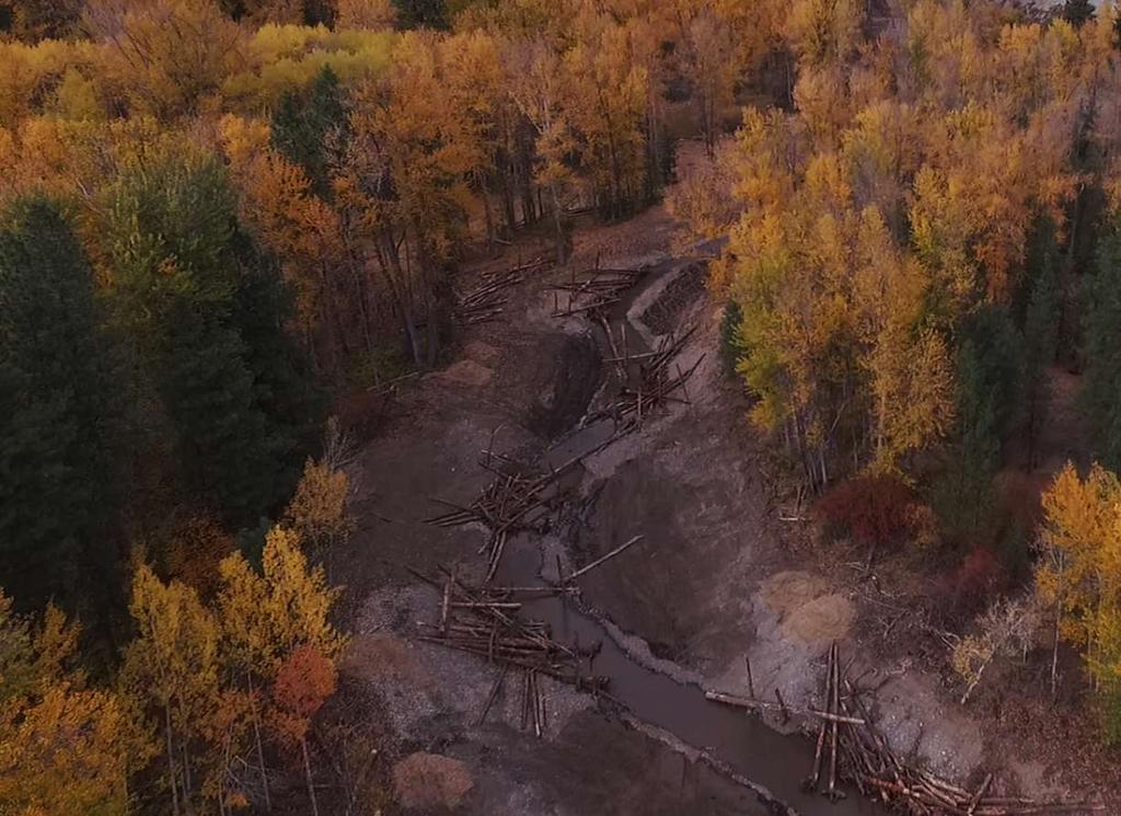
7 Natural Distribution of Large Wood In situ wood Channel spanning jams Clearwater River, WA Bar-apex jams Meander-bend jams

8 Recruitment: How does wood get into the stream? individual tree-fall due to mortality of riparian tree Large disturbance events: floods, fires, insect outbreaks, disease, landslides, and debris flows This is a caption 8

9 Retention: how does wood stay in the channel? How long does it stay? Size/complexity of wood Intact rootwad key pieces Bank erosion Size/complexity of channel bank protrusions, islands, gravel deposits, boulders, other wood pieces, bends Straightened, incised, armored This is a caption 9

10 2. Human impacts on large wood dynamics A. Riparian-source areas B. Recruitment C. Retention

11 A. Availability of large wood riparian stands are immature or permanently altered

12 B. Recruitment of large wood ability of streams to erode their banks, avulse, and fully access their channel migration zones has been limited or eliminated
13 C. Retention of large wood processes that are needed to retain wood in channels are altered due to channelization, removal of key pieces, and loss of complexity

14 What happened? Riparian clearing Log drives Snagging Channel alterations This is a caption Upper Wenatchee, WA 14


15 Leads to possible misperceptions of what rivers look like Natural Condition Altered Condition

16 How do we know there is less wood today? historical maps snagging records anecdotal accounts reference/analog sites This is a caption Skagit River logjams, 1873 Courtesy U.S. Bureau of Land Management 16

17 3. Design considerations of large wood projects
18 River restoration is multifaceted Geomorphology Social sciences Botany Cultural resources Civil engineering Hydrology Stream ecology Hydraulic engineering


19 Abundant information and study across many disciplines Water Resources Research Journal of Geophysical Research Earth Surface Geomorphology Journal of Hydraulic Engineering River Research and Applications Earth Surface Processes and Landforms Geological Society of America Bulletin International Journal of River Basin Management Regulated Rivers: Research and Management Science Restoration Ecology Environmental Management Hydrological Sciences Bulletin American Journal of Science

20 Use of large wood may be appropriate where: Channel/floodplain process or biological need identified Past wood removal Riparian zone has limited nearterm sources Potential log jam sites Upstream recruitment is lost Channel retention reduced Constraints limit restoration of recruitment and retention Clackamas River, OR

21 Use of large wood may not be appropriate where: High channel instability Placement would impair natural processes Placement would create risk to human safety or property Existing wood recruitment and retention are intact

22 Basic design processes Design concept Hydrology + basic geomorph Acknowledge Risk Hydraulic intuition (eyeball it) At-a-station hydraulics or analog design Identify Constraints 1-D, 2-D or other hydraulic model Moment force considerations Blissfully unaware of the dangers Hope for the best, maybe a bit nervous Fit the project to the geomorphic setting, sleep well
23 Basic design processes Design concept Hydrology + basic geomorph Acknowledge Risk Hydraulic intuition (eyeball it) At-a-station hydraulics or analog design Identify Constraints 1-D, 2-D or other hydraulic model Moment force considerations Blissfully unaware of the dangers Hope for the best, maybe a bit nervous Fit the project to the geomorphic setting, sleep well

24 Design Challenge: Balancing risk and other goals Risk to habitat Risk to infrastructure and property Hydraulic impacts Erosion Infrastructure damage Factors of safety Risk to public safety Recreation User groups Flooding and erosion hazards Uncertainty of technique Bruce Heiner
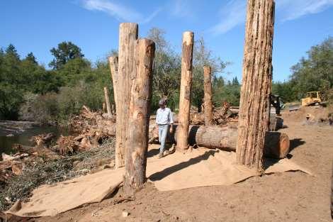
25 Integrate public safety into design process Consider public safety early in design Engage stakeholders throughout design Document decisions due diligence Be concerned about hazards and safety issues, but not intimidated by them All Wood In Stream Reach Recreational Problem Pieces Conflict Pieces Ecologically Most Functional Pieces Graphic courtesy of Kevin Colburn, American Whitewater

26 Design consideration: Site selection Tepee Creek, WA


27 Design consideration: Size of structure Klickitat River, WA West Fork Hood River, OR

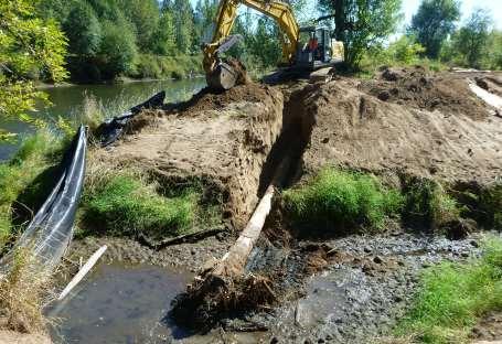
28 Design consideration: Placement and orientation Klickitat River, WA

29 Design consideration: Brush packing Salmon Creek, WA

30 Design consideration: Materials Whole trees Trees with rootwads Green trees Sources Wood removed from Swift Reservoir, Lewis River, WA
31 Design consideration: stability of large wood buoyancy drag and lift friction impact gravity
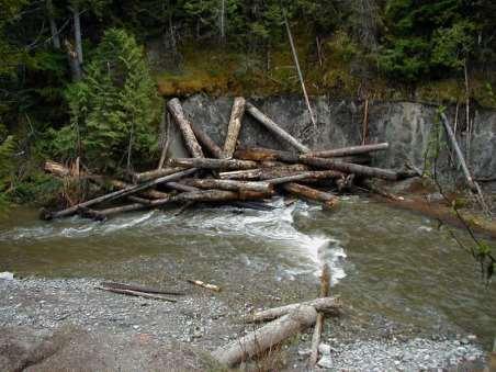

32 Design consideration: Anchoring Interlocking structure Vertical snag/piling Backfill Boulder Cedar Creek, WA
 Lewis")
33 Project consideration: Permitting Streamline permit FEMA No-Rise policy Public safety (signage) Lewis River, WA

34 Project consideration: Cost estimation Factors Size of project Source of material Numbers of pieces Size of pieces Transportation Access Dewatering

35 Construction considerations Access Sequencing Staging & material management Dewatering / bypass Erosion control Planting Buoyancy/ballast

36 Project consideration: Monitoring and maintenance Based on goals and objectives Implementation effectiveness Use by target species Performance Movement not necessarily failure Kelley Creek Long-term riparian function is very important!!

37 4. Large wood restoration projects

38 Small cover wood structures or individual pieces Focus is on cover, complexity, and velocity refuge Minimal geomorphic influence

39 Margin complexity Address cleared banks and riparian zones Localized cover, complexity, refuge Minimal geomorphic influence


40 Coarse wood Bundle wood if possible Place to depth of scour Min. embedment length 10 feet Low energy systems only Consider vegetatively reproducing plants

41 Meander bend jams Located where jams would naturally form Create and maintain scour pools Cover, complexity, refuge


42 Bar apex jam Located where jams would naturally form Create and maintain split flow conditions Sediment deposition Sometimes limited fish use during low flow periods 42

43 Bar apex jam Example: Bar apex jam to create habitat, protect island head and split flow 43


44 Before Toe stability Wood placement for habitat and toe stability Experimental bench areas to monitor sediment accumulation rates After


45 Ditch remeander Avulsion protection avoid recapturing the old channel Floodplain roughness control what overbank flows can do

46 Cribwall stabilization 46 Good in sand or erodible soils Need to be OK with the Lincoln-log aesthetic Can incorporate live wood Consider decay


47 Deflectors (variety of purposes) Deflectors to serve a variety of purposes Infrastructure protection Infrastructure protection Shift or direct stream energy Shift or direct stream energy Also provides cover, complexity, and refuge Also provides cover, complexity, and refuge Before Klickitat River

48 Structures to trap wood Requires a large wood supply from upstream Can use less wood in jam Positioning and configuration is important May need to provide stability for anticipated amount of accumulation Uncertainty in outcome

49 Floodplain Roughness Sub-bankfull vector High flow vector Sucker River, MN Mitigate for loss of floodplain hydraulic roughness Discourage avulsions Velocity refuge during floods


50 Floodplain Roughness Sucker River, MN 3 mos. post construction

51 Wood in tidal reaches Buoyant force Reverse flows Wet/dry vs. decay 2013
 Clackamas side channel entrance 2013")
52 Sensitive area protection Wood can be used to provide protection of: Side channel entrance and exits Channel mouth areas Sensitive areas (e.g. spawning) Clackamas side channel entrance 2013
 441-0342 mmelchior@interfluve.")
53 Thank you Caitlin Alcott (541) Marty Melchior (608) Inter-fluve.com
WWTP Protection Memo INTRODUCTION AND PURPOSE MODEL DEVELOPMENT AND ALTERNATIVES. August 31, PROJECT: TO: FROM: Re:
 WWTP Protection Memo August 31, 2017 PROJECT: TO: FROM: Re: City of Montesano WWTP Protection Log Jacks Matt Kastberg, Parametrix, Inc. Keelan Jensen, Dan Eggers, Henry Hu, WEST Consultants, Inc. WWTP
South St. Vrain / Hall Meadows Restoration Planning August 20, 2015
 South St. Vrain / Hall Meadows Restoration Planning August 20, 2015 Agenda Introductions Purpose & Goals of Meeting Planning Area Master Plan Restoration Planning: Cost Estimates, Grants, Scope, Timeline
STREAMBANK RESTORATION DESIGN
 STREAMBANK RESTORATION DESIGN WITH VINYL SHEET PILE GRADE CONTROL STRUCTURES BRUCE M. PHILLIPS, M.S., P.E. ABSTRACT Grade control structures are an effective channel stabilization measure which can eliminate
SECTION 5.4 LOGJAM REMOVAL AND RIVER RESTORATION
 SECTION 5.4 LOGJAM REMOVAL AND RIVER RESTORATION Logjams restrict the flow and conveyance of natural streams and ditches which can cause increased flooding, destruction of property and wildlife habitat,
In re: Town of Norwich Pool Dam Reconstruction, Stream Alteration Permit Application
 Agency of Natural Resources October 20, 2015 Neil R. Fulton Town Manager Town of Norwich P.O. Box 376 Norwich, VT 05055 In re: Town of Norwich Pool Dam Reconstruction, Stream Alteration Permit Application
Chehalis Basin Strategy Programmatic SEPA Draft EIS
 Chehalis Basin Strategy Programmatic SEPA Draft EIS History of Flooding I-5 closed in 1990, 1996, 2007, 2009 Five largest flood events occurred since 1986 2 History of Habitat Degradation Harvest has been
STREAM RESTORATION PURPOSE, PRACTICE, AND METHODS. By Marcus Rubenstein, CPESC
 STREAM RESTORATION PURPOSE, PRACTICE, AND METHODS By Marcus Rubenstein, CPESC WHAT IS STREAM RESTORATION? The return of a stream s lost natural functions, usually resulting from watershed alterations,
CHAPTER 3 Environmental Guidelines for WATERCOURSE CROSSINGS GOVERNMENT OF NEWFOUNDLAND AND LABRADOR DEPARTMENT OF ENVIRONMENT AND LABOUR
 GOVERNMENT OF NEWFOUNDLAND AND LABRADOR DEPARTMENT OF ENVIRONMENT AND LABOUR CHAPTER 3 Environmental Guidelines for WATERCOURSE CROSSINGS WATER RESOURCES MANAGEMENT DIVISION Water Investigations Section
FISH HABITAT RESTORATION DESIGNS FOR CAVE CREEK, WITHIN THE NAHWITTI RIVER WATERSHED
 FISH HABITAT RESTORATION DESIGNS FOR CAVE CREEK, WITHIN THE NAHWITTI RIVER WATERSHED Prepared for: Tom Cole, RPF Richmond Plywood Corporation 13911 Vulcan Way Richmond, B.C. V6V 1K7 March 2004 Prepared
Oatka Creek Stream Stabilization and Habitat Restoration Project Narrative
 Oatka Creek Stream Stabilization and Habitat Restoration Project Narrative This project was started from a previous Great Lakes Grant to identify concerns in the Oatka and Black Creek watersheds. Through
Rootwad Composites for Streambank Erosion Control and Fish Habitat Enhancement
 Rootwad Composites for Streambank Erosion Control and Fish Habitat Enhancement by Traci Sylte 1 and Craig Fischenich 2 May 2000 Complexity Low Moderate High High Environmental Value Low Moderate High High
f) Culverts in series shall be spaced at least 20 feet between each other. 2.7 C Culverts
 Culverts in series shall be spaced at least 20 feet between each other. 2.7 C Culverts") 2.7 C Culverts 1. General Culverts are intended to safely pass flow under road crossings. Criteria are designed to protect, maintain, and enhance public health, safety, and the environment. Where culverts
2.7 C Culverts 1. General Culverts are intended to safely pass flow under road crossings. Criteria are designed to protect, maintain, and enhance public health, safety, and the environment. Where culverts
Rootwad Composites for Streambank Erosion Control and Fish Habitat Enhancement
 Rootwad Composites for Streambank Erosion Control and Fish Habitat Enhancement by Traci Sylte 1 and Craig Fischenich 2 Complexity Environmental Value Moderate High Low I May 2000 Cost I Moderate High OVERVIEW
Environmental and Natural Resource Management Consultants
 Channel migration, big trees, side channels and the Sockeye (Blueback) Salmon: Design and implementation of a comprehensive sustainable restoration plan for the Upper Quinault River Valley, Washington
SKAGIT COUNTY PLANNING AND DEVELOPMENT SERVICES FINDINGS OF FACT. APPLICATION NUMBER: Shoreline Substantial Development Application PL
 SKAGIT COUNTY PLANNING AND DEVELOPMENT SERVICES FINDINGS OF FACT HEARING AUTHORITY: Skagit County Hearing Examiner HEARING DATE: April 24, 2013 APPLICATION NUMBER: Shoreline Substantial Development Application
Twelvemile Mainstem Instream Phase I and Phase II Restoration Monitoring Plan
 Twelvemile Mainstem Instream Phase I and Phase II Restoration Monitoring Plan Twelvemile Creek during road building and timber harvest in 1960. February 2013 Tongass National Forest, Craig Ranger District
Temporary Watercourse Crossing: Culverts
 Temporary Watercourse Crossing: Culverts DRAINAGE CONTROL TECHNIQUE Low Gradient Velocity Control Short Term Steep Gradient Channel Lining Medium-Long Term Outlet Control Soil Treatment Permanent Symbol
Missouri Streams. Fact Sheet. What factors affect stream habitat? Stream Habitat Affects Aquatic Communities
 Missouri Streams Fact Sheet Written by Del Lobb & Suzanne Femmer Edited by Sarah Wolken When most people think of habitat, they usually picture places where fish or wildlife live, like a hollow log or
1. Use Conceptual Ecosystem Models. Leigh Skaggs, Office of Water Project Review
 Recent Experiences with Cost Effectiveness and Incremental Cost Analyses (CE/ICA) for Ecosystem Restoration Projects Leigh Skaggs, Office of Water Project Review Recent reviews of Civil Works ecosystem
The Second Life of Logs
 The Second Life of Logs Developed by: Richard Burton Adapted from: Council of Environmental Education. 2004. Wetland Metaphors Project Wild Aquatic: K-12 Curriculum and Activity Guide. Houston, TX: Council
Construction of Artificial Riffles and Pools For Freshwater Habitat Restoration
 Construction of Artificial Riffles and Pools For Freshwater Habitat Restoration Kate Howe Preserving biodiversity is one of the central goals of ecologists and conservation biologists today. As human population
ECOSYSTEM HEALTH AND SALMON RESTORATION: A BROADER PERSPECTIVE
 Orr 1 ECOSYSTEM HEALTH AND SALMON RESTORATION: A BROADER PERSPECTIVE BRUCE K. ORR Stillwater Sciences, Berkeley, California, USA ABSTRACT An understanding of healthy, naturally functioning riverine and
Developing Tools for Hydromodification Management and Assessment
 Developing Tools for Hydromodification Management and Assessment Hydromodification: Channel Erosion Before Development After Development Increase in: - Imperviousness - Drainage Slope - Direct Runoff Decrease
Flood Risk Management on the Elwha: Case Study of the Federal Levee Modification Project
 Flood Risk Management on the Elwha: Case Study of the Federal Levee Modification Project US Army Corps of Engineers Zac Corum, PE, Hydraulic Engineer Travis Ball, PE, CFM, Hydraulic Engineer Seattle District
Hydrology and Flooding
 Hydrology and Flooding Background The 1996 flood Between February 4, 1996 and February 9, 1996 the Nehalem reporting station received 28.9 inches of rain. Approximately 14 inches fell in one 48 hour period.
Low Head Stone Weirs By: Jon Fripp 1, Dr. Craig Fischenich 2, and Dr. David Biedenharn 2
 Low Head Stone Weirs By: Jon Fripp 1, Dr. Craig Fischenich 2, and Dr. David Biedenharn 2 Complexity Low Moderate High Environmental Value Low Moderate High Cost Low Moderate High OVERVIEW Establishing
4.1 Traditional Approach versus Geomorphic Approach
 RESTORATION 4.0 Introduction As we discussed in the Watersheds and Streams Section, many streams have been severely impacted by urbanization as a result of changes in their hydrologic and sediment regimes,
AP Environmental Science
 2017 AP Environmental Science Sample Student Responses and Scoring Commentary Inside: RR Free Response Question 4 RR Scoring Guideline RR Student Samples RR Scoring Commentary 2017 The College Board. College
Good morning, Chairman Yaw, Chairman Yudichak, Chairman Vulakovich, Chairman Costa,
 Testimony of Patrick McDonnell, Secretary Pennsylvania Department of Environmental Protection Joint Hearing on Flooding and Emergency Response Senate Environmental Resources & Energy and Veterans Affairs
Habitat Grant Projects Clinton River Watershed
 Habitat Grant Projects Clinton River Watershed L Y N N E S E Y M O U R E N V I R O N M E N T A L E N G I N E E R O F F I C E O F T H E M A C O M B C O U N T Y P U B L I C W O R K S C O M M I S S I O N
LOW WATER CROSSINGS, fords, or drifts, as they
 Chapter 9 For ords and Low-Water Crossings Keep the ford profile low, armor the driving surface, and protect against scour. LOW WATER CROSSINGS, fords, or drifts, as they are commonly called, can offer
Adjusted Flood Prone Acres
 Adjusted Flood Prone Acres The flood prone area is defined as the area adjacent to the stream that is innundated or saturated when the elevation of the water is at twice the maximum depth at bankfull stage
Project sponsors provided a brief presentation on their project(s), followed by comments from the Committee.
, followed by comments from the Committee.") WRIA 14 Salmon Habitat Recovery Committee Meeting April 17, 2014 Summary notes Project sponsors provided a brief presentation on their project(s), followed by comments from the Committee. Allyn Shoreline
WRIA 14 Salmon Habitat Recovery Committee Meeting April 17, 2014 Summary notes Project sponsors provided a brief presentation on their project(s), followed by comments from the Committee. Allyn Shoreline
Watershed Investigations: How to Assess the Health of a Stream
 Watershed Investigations: How to Assess the Health of a Stream By Joan Chadde, Western UP Center for Science, Mathematics & Environmental Education. All photos by author, unless otherwise noted. Why Monitor
INTRODUCTION AND PURPOSE OF THE DESIGN GUIDE
 B A N K P R OT E C T I O N/E R O S I O N R E PA I R D E S I G N G U I D E INTRODUCTION AND PURPOSE OF THE DESIGN GUIDE This Design Guide is intended to clarify the Chapter 1 of the Water Resources Infrastructure
Geomorphologic Condition and Shallow Aquifers
 Geomorphologic Condition and Shallow Aquifers Shann Stringer Center for Ecological Sciences Geomorphology Fluvial geomorphology is the study of the physics of water, sediment, riparian area, and floodplain
Planning and Combination (Planning and Acquisition) Project Proposal
 Project Proposal") Planning and Combination (Planning and Acquisition) Project Proposal Project Number 15-1308 Project Name Asotin County Geomorphic/Watershed Assessment Sponsor Asotin County Conservation District List all
Planning and Combination (Planning and Acquisition) Project Proposal Project Number 15-1308 Project Name Asotin County Geomorphic/Watershed Assessment Sponsor Asotin County Conservation District List all
Oregon Department of State Lands. Protecting Natural and Fiscal Resources to Support Schools
 Oregon Department of State Lands Protecting Natural and Fiscal Resources to Support Schools Heidi Hartman Jefferson, Hood River, Sherman, Wasco, Morrow, Gilliam, Union, Baker, Grant, Wallowa, Umatilla,
COON CREEK WATERSHED DISTRICT PERMIT REVIEW. Spring Lake Park Schools Westwood Middle School st Avenue NE, Spring Lake Park, MN 55432
 PAN 16-112, Westwood Middle School, Page 1 of 6 COON CREEK WATERSHED DISTRICT PERMIT REVIEW MEETING DATE: August 22, 2016 AGENDA NUMBER: 10 FILE NUMBER: 16-112 ITEM: Westwood Middle School RECOMMENDATION:
Environmental Flow Regimes. Joe Trungale s presentation to the Science Advisory Committee March 4, 2009
 Overlays to Hydrology-Based Environmental Flow Regimes Joe Trungale s presentation to the Science Advisory Committee March 4, 2009 Overlays - Definition Application of analysis to validate or refine flow
AQUATIC ECOSYSTEM RESTORATION PROJECT
 AQUATIC ECOSYSTEM RESTORATION PROJECT EFFECTS OF THE FLOODS OF 1996 QUARTZ CREEK WILLAMETTE NATIONAL FOREST Submitted by: Dr. Stan Gregory Randy Wildman Department of Fisheries and Wildlife Oregon State
Chapter Three: Discussion and Conclusion. 3.1 Introduction/Overview. 3.2 Countywide Stream Assessment
 3.1 Introduction/Overview The objective of this study was to develop a stream prioritization tool that evaluates stream reaches in terms of the potential water quality improvements that could be achieved
ANNUAL PROGRESS REPORT FOR 2014 ROGUE RIVER SPRING CHINOOK SALMON CONSERVATION PLAN ROGUE WATERSHED DISTRICT OREGON DEPARTMENT OF FISH AND WILDLIFE
 ANNUAL PROGRESS REPORT FOR 2014 ROGUE RIVER SPRING CHINOOK SALMON CONSERVATION PLAN ROGUE WATERSHED DISTRICT OREGON DEPARTMENT OF FISH AND WILDLIFE INTRODUCTION In September of 2007, the Oregon Fish and
Stream Watch Visual Survey Instructions
 Stream Watch Visual Survey Instructions The Stream Watch Visual Survey is based on assessment parameters from the EPA's Rapid Bioassessment Protocol Habitat Assessment, Georgia Adopt a Stream Visual Survey,
Mike Jastremski, CFM Watershed Conservation Director
 Planning for Flood Resilient and Fish Friendly Road-Stream Crossings in CT s Northwest Hills Mike Jastremski, CFM Watershed Conservation Director Presentation Outline Project area Climate threats Field
Successful Floodplain Reconnection
 Successful Floodplain Reconnection Design, Implementation, Monitoring and Adaptive Management Upper Truckee River, Lake Tahoe, California Michael Rudd, PE, Charley Miller PE, Virginia Mahacek, Chad Krofta
What Are Environmental (Instream) Flows?
 Flows?") 1 What Are Environmental (Instream) Flows? Sustainable water management requires that both human needs and the needs of aquatic and riparian ecosystems be fulfilled. Dams and diversion of water for municipal
1 What Are Environmental (Instream) Flows? Sustainable water management requires that both human needs and the needs of aquatic and riparian ecosystems be fulfilled. Dams and diversion of water for municipal
Fish Habitat Design, Operation and Reclamation Workbook and Worksheets for Placer Mining in the Yukon Territory
 Fish Habitat Design, Operation and Reclamation Workbook and Worksheets for Placer Mining in the Yukon Territory Version 1.3 November 2010 This document is available from: Yukon Placer Secretariat, 206B
CHAPTER 7. San Dieguito River Flooding Adaptation
 CHAPTER 7 San Dieguito River Flooding Adaptation This chapter includes a range of adaptation measures to address vulnerabilities from flooding along the San Dieguito River, including the river valley,
Honeysuckle Reservoir decommissioning
 Honeysuckle Reservoir decommissioning Christopher Dwyer Earth Tech, PO Box 165 Wangaratta, 3676. Web: www.earthtech.com.au, Email: chris.dwyer@earthtech.com.au Abstract Often significant investment is
Lyon Creek Cedar Way Stormwater Detention Dam Operation and Maintenance Manual
 Lyon Creek Cedar Way Stormwater Detention Dam Operation and Maintenance Manual Prepared by: Mike Shaw Stormwater Program Manager City of Mountlake Terrace January 2010 Section I General Information This
Environmental Protection (NJDEP) The Louis Berger Group, Inc.
 The Louis Berger Group, Inc.") Hydraulic Modeling for Preliminary Evaluation of Potential Flooding Impacts for Various Dredging, Capping and Armoring Scenarios of The Lower Passaic River Restoration Abdulai Fofanah, PE, D.WRE, CFM Murat
Hydraulic Modeling for Preliminary Evaluation of Potential Flooding Impacts for Various Dredging, Capping and Armoring Scenarios of The Lower Passaic River Restoration Abdulai Fofanah, PE, D.WRE, CFM Murat
APPENDIX A HYDROLOGIC AND HYDRAULIC ANALYSIS
 APPENDIX A HYDROLOGIC AND HYDRAULIC ANALYSIS GENERAL The Hydrologic and Hydraulic information presented in this appendix is provided as a supplement to the Dallas Floodway Extension General Re-evaluation
Flood Hazard Assessment Report Falls Gulch, Larimer County, Colorado January 16, 2013
 United States Department of Agriculture Natural Resources Conservation Service Denver Federal Center Building 56, Room 2604 P.O. Box 25426 Denver, CO 80225 720-544-2818-OFFICE alton.albin@co.usda.gov Flood
Municipal Class Environmental Assessment for Pottersburg Creek Slope Stability Study South of Hamilton Road, Schedule B
 Municipal Class Environmental Assessment for Pottersburg Creek Slope Stability Study South of Hamilton Road, Schedule B February 13, 2013 Municipal Class EA Process We are here Purpose and Objective of
Applying Ecosystem Services to Collaborative Forest Management Elk River Public Meeting
 Applying Ecosystem Services to Collaborative Forest Management Elk River Public Meeting Nikola Smith Ecologist and Ecosystem Services Specialist U.S. Forest Service Port Orford City Hall February 2, 2017
Appendix H: Stream Habitat Assessment
 Appendix H: Stream Habitat Assessment H CH2MHill and Greenways Incorporated conducted Stream Habitat Assessments on several streams throughout Wake County to determine the affect of development density
Queen Charlotte Islands Project
 Queen Charlotte Islands Project 1981 Introduction The Queen Charlotte Islands Fish-Forestry Interaction Program was an interdisciplinary study assessing the interactions between timber harvesting operations
Chapter 11 Culverts and Bridges
 Chapter 11 Culverts and Bridges Contents 1.0 Introduction... 1 2.0 General Design... 1 2.1 Design Criteria... 1 2.2 Design Flows... 1 2.3 Permitting and Regulations... 1 2.4 Aesthetics and Safety... 2
FEMA s Mitigation Support for Resiliency: Innovative Drought and Flood Mitigation Projects
 FEMA s Mitigation Support for Resiliency: Innovative Drought and Flood Mitigation Projects Jordan Williams, CFM Eric Kenney, PE, CFM May 4, 2017 2 Hazard Mitigation Purpose: Research climate resilient
Kootenai River Habitat Restoration Project Master Plan. Chapter 5 Adaptive Management and Monitoring
 Kootenai River Habitat Restoration Project Master Plan Chapter 5 Adaptive Management and Monitoring July 2009 Chapter 5: Table of Contents 5 Adaptive Management and Monitoring...5 1 5.1 Overview... 5 1
Site Selection and Design for Stream Mitigation
 Site Selection and Design for Stream Mitigation Will Harman, PG Stream Mechanics The Association of State Wetland Managers State/Tribal/Federal Coordination Meeting March 19-21, 2013 NCTC Our Relationship
Building Resilient Communities - Low Impact Development and Green Infrastructure Strategies
 Building Resilient Communities - Low Impact Development and Green Infrastructure Strategies October 24, 2013 Bridgewater State University E. Heidi Ricci Senior Policy Analyst Mass Audubon Shaping the Future
General Authorization
 Department State Lands General Authorization Notification Packet Contents A. Instructions for completing the General Authorization Notice, and Fee Explanation Page 2 B. General Authorization Eligibility
GOING WITH THE FLOW: DESIGN TECHNIQUES TO IMPROVE RAW WATER QUALITY
 GOING WITH THE FLOW: DESIGN TECHNIQUES TO IMPROVE RAW WATER QUALITY ABSTRACT Porter Rivers, III, PE URS Corporation Keith Cannon, PE URS Corporation Geoff Smith, PE URS Corporation Ken Green, Eastern Band
Interstate-Callahan Upper and Lower Rock Dumps RA Construction Project. East Fork Ninemile Creek, Idaho May 3, 2016
 Interstate-Callahan Upper and Lower Rock Dumps RA Construction Project East Fork Ninemile Creek, Idaho May 3, 2016 Tony Wesche, P.E. Pioneer Technical Services, Inc. and North Wind Group Presentation Topics
Prepared for: Whippany River Watershed Action Committee c/o Arthur Vespignani, Facilitator P.O. Box 223 Morristown, NJ
 Stream Bank Stabilization Design for the Whippany River at the Whippany Burying Grounds Southeast of the Intersection of Troy Hills Road and State Route 10 Block 5901, Lot 15 Hanover Township, Morris County,
Provide flood damage reduction projects that t work, with appropriate regard for community and natural values.
 The mission of the Harris County Flood Control District is to: Provide flood damage reduction projects that t work, with appropriate regard for community and natural values. Harris County Flood Control
A Habitat Monitoring Plan to Test the Effectiveness of Stream Restoration in the Tucannon River, Washington
 A Habitat Monitoring Plan to Test the Effectiveness of Stream Restoration in the Tucannon River, Washington Submitted to Snake River Salmon Recovery Board 410B East Main Street Dayton, Washington 99328
North Fork Lewis River
 North Fork Lewis River Haapa Fish Habitat Restoration Project Final Design Report PREPARED FOR Lower Columbia Fish Enhancement Group JUNE 2014 North Fork Lewis River Haapa Fish Habitat Restoration Project
The status of aquatic ecosystems in the Basin
 AQUATIC SPECIES AND HABITATS The status of aquatic ecosystems in the Basin is influenced by both natural and human processes. The geologic and geomorphic processes described earlier formed and continue
NetMap Community Digital Watersheds & Shared Analysis Tools
 NetMap Community Digital Watersheds & Shared Analysis Tools Earth Systems Institute U. S. Forest Service, Pacific Northwest Experiment Station & Collaborating Agencies The NetMap Project Collaborators:
Supplemental Watershed Plan Agreement No. 10 for Neshaminy Creek Watershed Core Creek Dam (PA-620) Bucks County, Pennsylvania
 Bucks County, Pennsylvania") Supplemental Watershed Plan Agreement No. 10 for Neshaminy Creek Watershed Core Creek Dam (PA-620) Bucks County, Pennsylvania Project Authorization USDA's Small Watershed Program is carried out under the
Supplemental Watershed Plan Agreement No. 10 for Neshaminy Creek Watershed Core Creek Dam (PA-620) Bucks County, Pennsylvania Project Authorization USDA's Small Watershed Program is carried out under the
Finding Common Ground between Ecosystem Services and Environmental Ecosystems
 Finding Common Ground between Ecosystem Services and Environmental Ecosystems Elizabeth H. Smith, Ph.D. Nicole A. Davis, B.S. Center for Coastal Studies Texas A&M University-Corpus Christi Project funding
FY16 RSM IPR Portland District, Optimizing Fall Creek Reservoir Flush TMDL s, Stanford Gibson, Chris Nygaard, Jim Crain, Jarod Norton
 Fall Creek Reservoir Fall Creek Dam is at river mile 7.2 on Fall Creek, a tributary of the Willamette River, about 20 miles southeast of Eugene, OR. Dam works in coordination with Lookout Point and Hills
Projects Recommended for Funding
 2017-2019 Projects Recommended for Funding The Floodplains by Design coalition requests continued funding at the $60 million level in the FY 2017-19 capital budget. This request will fund new projects
Project Goals and Scoping
 Prepared for: Boulder County, Colorado Flood Planning & Preliminary Design Services for South St. Vrain Creek Restoration at Hall Ranch and Scoping May 24, 2016 Meeting with General Public In association
REMAP approach produce unbiased estimates of conditions Random site selection Measure fish and macroinvertebrate populations, chemistries (water,
 REMAP approach produce unbiased estimates of conditions Random site selection Measure fish and macroinvertebrate populations, chemistries (water, sediment, fish tissue) and habitat (instream, steam banks,
Types of Hydropower Facilities
 Types of Hydropower Facilities 1 Impoundment Hydropower- uses a dam to store water. Water may be released either to meet changing electricity needs or to maintain a constant water level. 2 Run-of-River
Rainfall, runoff and sediment transport in the Napa River watershed: now and a possible future
 Rainfall, runoff and sediment transport in the Napa River watershed: now and a possible future Lester McKee San Francisco Estuary Institute 5/24/2017 1 The importance of the natural water cycle of infiltration
The McKenzie River Watershed Conservation Strategy
 The McKenzie River Watershed Conservation Strategy January 2002 The McKenzie Watershed Council Fostering better stewardship of McKenzie Watershed resources through voluntary partnerships and collaboration.
Flow-ecology relationships. Flow-ecology relationships Susitna case study
 Flow-ecology relationships Flow-ecology relationships Susitna case study Flow regime Ecologically-Relevant Flow Regime Characteristics Seasonal or typical conditions Annual extreme conditions High and
Carp Creek 2013 Summary Report
 Monitoring Activity in the Carp River Watershed In 2012, Mississippi Valley Conservation Authority (MVCA) worked with Friends of the Carp River (FCR) on a preliminary assessment of the Carp River. This
Duwamish Waterway Self Guided Tour: Turning Basin Number Three and Terminal 105 Aquatic Habitat Restoration Sites
 Duwamish Waterway Self Guided Tour: Turning Basin Number Three and Terminal 105 Aquatic Habitat Restoration Sites Text and illustrations in the following pages include: (1) summary information describing
East Fork Illinois River Channel and Floodplain Restoration Project
 East Fork Illinois River Channel and Floodplain Restoration Project Wild Rivers Ranger District, Rogue River-Siskiyou National Forest /s/ Joni D. Brazier Date: February 20, 2015 Joni D. Brazier, Forest
E. STORMWATER MANAGEMENT
 E. STORMWATER MANAGEMENT 1. Existing Conditions The Project Site is located within the Lower Hudson Watershed. According to the New York State Department of Environmental Conservation (NYSDEC), Lower Hudson
Engineering With Nature. Alternative Techniques to Riprap Bank Stabilization
 Engineering With Nature Alternative Techniques to Riprap Bank Stabilization Engineering With Nature Alternative Techniques to Riprap Bank Stabilization Contents Introduction...7 Hamakami Strawberry Farm...11
Estimation of rearing habitat requirements of San Joaquin River Chinook salmon using the Emigrating Salmonid Habitat Estimation (ESHE) Model
 Model") Estimation of rearing habitat requirements of San Joaquin River Chinook salmon using the Emigrating Salmonid Habitat Estimation (ESHE) Model California Central Valley Cramer Fish Sciences *Draft conceptual
Estimation of rearing habitat requirements of San Joaquin River Chinook salmon using the Emigrating Salmonid Habitat Estimation (ESHE) Model California Central Valley Cramer Fish Sciences *Draft conceptual
Follow this and additional works at:
 University of Massachusetts - Amherst ScholarWorks@UMass Amherst International Conference on Engineering and Ecohydrology for Fish Passage International Conference on Engineering and Ecohydrology for Fish
Presentation Overview
 Little Dry Creek Restoration Deep River Flood Risk Management Final Presentation to LCRBDC June 10, 2015 Presentation Overview Project Overview & Background Information Data Collection Model Development
SECTION 7.0 PROJECT FEASIBILITY, ENGINEER S RECOMMENDATION AND DESIGN ISSUES NEEDING RESOLUTION
 SECTION 7.0 PROJECT FEASIBILITY, ENGINEER S RECOMMENDATION AND DESIGN ISSUES NEEDING RESOLUTION 7.1 PROJECT FEASIBILITY The determination of project feasibility is based upon several criteria established
CITY OF KIMBERLEY HYDROLOGICAL & HYDRAULIC ASSESSMENT
 HYDROLOGICAL & HYDRAULIC ASSESSMENT ISSUED FOR USE January 31, 2012 FILE: 2011-015 LACAS CONSULTANTS INC. CONSULTING ENGINEERS & HYDROLOGICAL SPECIALISTS, SINCE 1991 Suite 200, 1311 Howe Street, Vancouver,
3.13 Water Bodies and Water Quality Affected Environment
 3 Affected Environment and Environmental Consequences 3.13 Water Bodies and Water Quality 3.13.1 Affected Environment 3.13.1.1 Water Bodies Sterling Highway MP 45 60 Project Draft SEIS Water within the
King County Flood Control District Advisory Committee 2015 Work Program and Budget Introduction June 26, 2014
 King County Flood Control District Advisory Committee 2015 Work Program and Budget Introduction June 26, 2014 Green River SWIF, Capital Project Status, and Future Needs June 26, 2014 King County Water
Design Features of Constructed Wetlands for Nonpoint Source Treatment. September 1995
 Design Features of Constructed Wetlands for Nonpoint Source Treatment September 1995 Brochure written by William W. Jones, School of Public and Environmental Affairs, Indiana University, Bloomington, Indiana.
Freight Street Development Strategy
 Freight Street Development Strategy Appendix B: Naugatuck River Floodplain Analysis Freight Street Development Strategy DECEMBER 2017 Page B-1 1.0 NAUGATUCK RIVER FLOODPLAIN AT FREIGHT STREET 1.1 Watershed
Chapter 10 Natural Environment
 Chapter 10 Natural Environment Existing Conditions The Natural Environment Element addresses the protection, conservation, preservation, and restoration of the natural resources the Bayview Ridge Subarea,
SW-74 SERENOVA PRESERVE SITES 2, 3, 4, 8 MITIGATION PLAN
 SW-74 SERENOVA PRESERVE SITES 2, 3, 4, 8 MITIGATION PLAN BACKGROUND INFORMATION Project SWIM? Aquatic Control? Exotic Control? Mitigation Bank? Type No No No No Mitigation Restoration and enhancement Type
RIPARIAN CORRIDOR STUDY FINAL PARLEYS CREEK MANAGEMENT PLAN TABLE OF CONTENTS
 TABLE OF CONTENTS 1.0 INTRODUCTION... 1-1 Riparian Corridor Study and Management Plan Goals... 1-1 Study Area... 1-2 Importance and Functions of Riparian Corridors... 1-2 Habitat for Mammals, Birds, and
U.S. Army Corps of Engineers Mobile District
 U.S. Army Corps of Engineers Mobile District General Permit for Living Shorelines in Alabama Sandy P. Gibson Regulatory Specialist, Coastal Alabama Regulatory Division, Mobile District US Army Corps of