Mike Jastremski, CFM Watershed Conservation Director
|
|
|
- Ambrose Franklin
- 6 years ago
- Views:
Transcription


1 Planning for Flood Resilient and Fish Friendly Road-Stream Crossings in CT s Northwest Hills Mike Jastremski, CFM Watershed Conservation Director
2 Presentation Outline Project area Climate threats Field assessment Modelling flood vulnerability Setting priorities Designing replacement projects Integrating with local planning
3 HVA covers the entire Housatonic watershed: MA 149 main-stem miles Roughly 4,200 tributary miles NY CT Riverside in Kent
4 HVA covers the entire Housatonic watershed: MA The Housatonic River: 149 miles long Vertical drop of 1,430 feet 83 towns in 3 states NY CT and emptying into Long Island Sound at Stratford and Milford Point, CT
5 HVA covers the entire Housatonic watershed: MA The Housatonic River: 149 miles long Vertical drop of 1,430 feet 3 states and 83 towns 1,948 square miles (1.2 million acres) NY CT

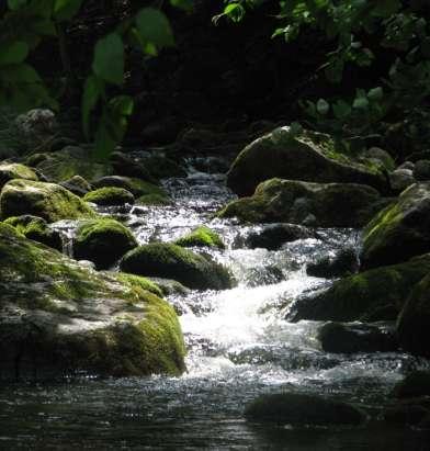
6 Housatonic River Valley, Sharon/Cornwall


7 From Appalachian Trail in Falls Village, looking toward Berkshires Photo: Bill Wakely

8 Morning mist Kent, CT
9
10 Presentation Outline Project area Climate threats Field assessment- identify barriers Model flood vulnerability \ Set priorities Design replacement projects Integrate with local planning

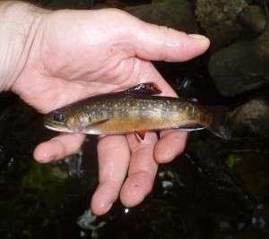
11 Climate Threats: More Rain

12 Climate Threats: More Rain July Sharon, CT County Times Source: Litchfield
13 Climate Threats: Water Quality Increase in polluted runoff o Problems with stormwater runoff we re used to

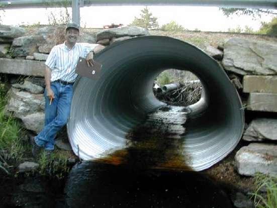
14 Climate Threats: Water Quality and pollution inputs from major floods that we re not as familiar with


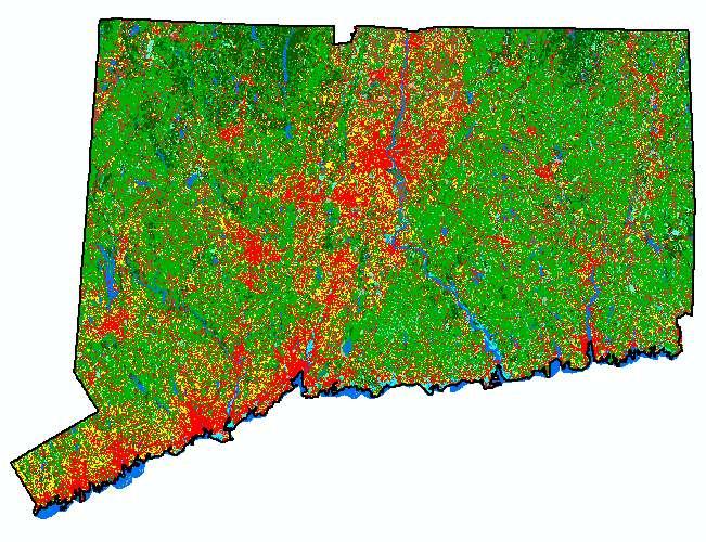
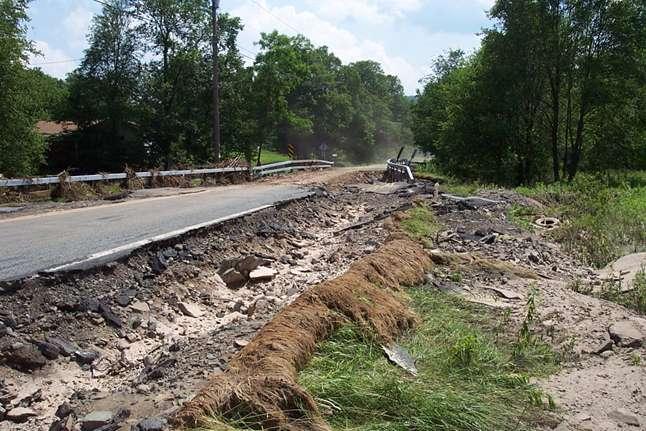
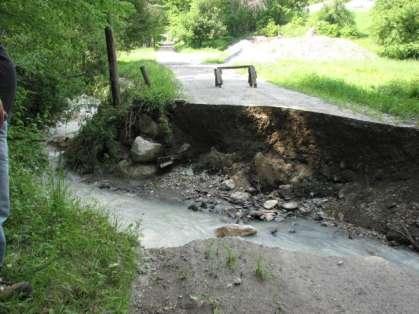
15 Climate Threats: Water Quality Bigger floods = stream instability o Increased erosion

16 Climate Threats: Rising Temperatures

17 Climate Threats: Habitat Increasing water temperatures, contracting cold-water habitat
18 Importance of Movement Reproduction Daily and seasonal Movement is Key to Changes in habitat Genetic diversity Adaptation Colonization

19 Roads and Streams Fragmentation Prevents Adaptation Undersized Culverts = More Flood Damage
20 Dams
21 Sub-standard Culverts
22 Housatonic streams in CT
23 Dams not comprehensive!)
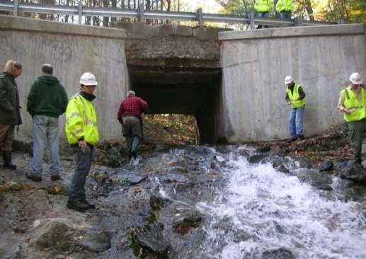
24 Roads and railroads
25 Road-stream crossings
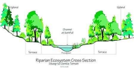
26 Dams and crossings
27 Project Goals Respond to climate threats and scale of barrier problem: Identify replacement projects that both reduce flood risk and reconnect important habitat Build local capacity to take advantage of every opportunity to replace problem culverts


28 Town-Scale Management Plans 7 towns Evaluate flood risk and conservation value
29 Town-Scale Management Plans Create town-specific Road-Stream Crossing Inventory docs Use Inventory to set priorities
30 Presentation Outline Project area Climate threats Field assessment Modelling flood vulnerability Town prioritization workshops Designing replacement projects Integrating with local planning
31 Field Assessment
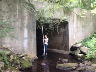
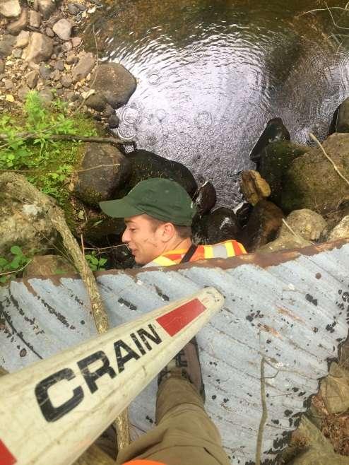
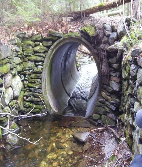
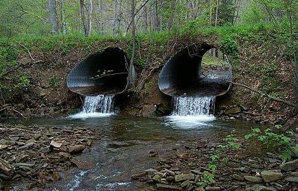
32 Field Assessment
33 Stream Shape: Cross-sectionsection
34 Stream Shape: Pattern Pattern is a stream s shape from above Placement of features like meander bends, pools and riffles Adapted from North Carolina Cooperative Extension Service, 1999
35 Stream Shape: Slope

36 Field Assessment Excessive Velocities

37 Inlet Drop

38 Scour Hole

39 Outlet Drop (Perching)

40 Tail Water Armoring
41 Insufficient Water Depth


42 Results Since crossings assessed in project area Barriers common and widespread Many barrier crossings managed by towns with limited resources
43 Stream Habitat Fragmentation Barrier Evaluation Number Percentage Severe barrier % Significant barrier 61 10% Moderate barrier % Minor Barrier % Insignificant Barrier 42 7% No barrier (full passage) 0 0% Of 604 assessed culverts, 356 are moderate to severe barriers 59%!

44 Dams and crossings Fragmentation Prevents Adaptation
45 Presentation Outline Project area Climate threats Field assessment Modelling flood vulnerability Town prioritization workshops Designing replacement projects Integrating with local planning


46 Simulating Flood Risk How do we predict whether or not this culvert will flood the road? Culvert Inlet

 USGS (Q)")
47 Force CREST Model HVA is partnering with UCONN CREST Model Combining the model with field data, UCONN can simulate which crossings will flood the road Distributed Variables Land Cover Soil Properties Vegetation Library Impervious Area GIS-Terrain elevation flow direction Stream network Remotely Sensed Products Leaf Area Index Water Balance Interception Evaportranspiration Snow Process Infiltration ET Runoff Fully Distributed Routing Routing parameters T W Hourly MeteorologIc Variables climatology Precipitation Energy Balance Atmospheric Layer Canopy Layer Snow Pack Layer Surface Soil Layer Deep Soil Layer River discharge (Q) USGS (Q) Calibration
48 Undersized Culverts = More Flood Damage
49 Presentation Outline Project area Climate threats Field assessment Modelling flood vulnerability Town prioritization workshops Designing replacement projects Integrating with local planning
50 Presentation Outline Project area Climate threats Field assessment Modelling flood vulnerability Town prioritization workshops Designing replacement projects Integrating with local planning

51 Design Phase Leverage limited funding Enormous scale of problem Build capacity at municipal level

52 Stream Simulation Design Road-stream crossing design that mimics the natural stream channel through a structure, as if the crossing didn t exist.
53 Stream Shape: Cross-sectionsection

54 Stream Shape: Pattern Pattern is a stream s shape from above Placement of features like meander bends, pools and riffles Adapted from North Carolina Cooperative Extension Service, 1999
55 Stream Shape: Slope

56 Stream Simulation Design Width of a Stream Simulation Design structure is spans the natural bed and banks.
57 Stream Simulation Design

58 Stream Simulation Design Minimizes stream skew
59 Stream Simulation Design Substrate designed to replicate natural streambed allowing for mobility and dynamic response to the need for additional capacity.

60 Flood Resiliency Provides sufficient hydraulic capacity and passage of debris

61 Flood Resiliency Reduces the likelihood of clogging, upstream ponding, and road overtopping.
62 Economic Benefits Lower long-term cost over the lifespan of the structure as compared to an in kind replacement: Less maintenance Less repair Reduced flood damage

63 Economic Benefits These cost saving factors will become more and more relevant as storms increase in both intensity and frequency due to climate change.


64 Economic Benefits Stream Sim = New Funding Opportunities

65 Stream Simulation Design Stream Simulation Design is good for everyone: Economic benefits for local communities Habitat improvement for native species Resilient infrastructure
66 Presentation Outline Project area Climate threats Field assessment Modelling flood vulnerability Town prioritization workshops Designing replacement projects Integrating with local planning

67 Town-Scale Management Plans Combine: Inventory Ranking Conceptual designs Supporting information Adopt as part of Hazard Mitigation Plan

68


69 Partners, Funders and Advisors Housatonic River NRD Trustees Town of Cornwall, CT
REPLACING CULVERTS FOR FLOOD RESILIENCY AND AQUATIC CONNECTIVITY. Cheryl Bondi and Lori Sommer NHDES Aquatic Resource Mitigation Program
 REPLACING CULVERTS FOR FLOOD RESILIENCY AND AQUATIC CONNECTIVITY Cheryl Bondi and Lori Sommer NHDES Aquatic Resource Mitigation Program How do stream crossings impact aquatic ecosystems and public safety?
Integrating Biodiversity & Infrastructure Priorities
 Integrating Biodiversity & Infrastructure Priorities Bill Napolitano Director of Environmental Planning, Southeastern Regional Planning and Economic Development District Jennifer Carlino Conservation Agent
Designing roads for fish, floods and foxes
 Designing roads for fish, floods and foxes Calculations 9 Swimming Plunging Flow & Leaping Occupied Velocity Prolonged > Capability Yes Swim in Burst Total Time in Burst Time to > Exhaustion Yes Barrier
DRAINAGE MASTER PLAN FOR THE TOWN OF BLOOMING GROVE AND VILLAGES OF WASHINGTONVILLE AND SOUTH BLOOMING GROVE
 DRAINAGE MASTER PLAN FOR THE TOWN OF BLOOMING GROVE AND VILLAGES OF WASHINGTONVILLE AND SOUTH BLOOMING GROVE PUBLIC MEETING March 8, 2017 LOGISTICS Meeting Agenda: Presentation (7:15 7:45 pm) [Auditorium]
Wood-Pawcatuck Watershed Flood Resiliency Management Plan Community Meeting October 20, 2016
 Wood-Pawcatuck Watershed Flood Resiliency Management Plan Community Meeting October 20, 2016 Wood-Pawcatuck Watershed Association Meeting Agenda 10:00 10:05 Introductions and Meeting Goals 10:05 10:15
Massachusetts River and Stream Crossing Standards: Technical Guidelines
 Massachusetts River and Stream Crossing Standards: Technical Guidelines August 6, 2004 INTRODUCTION As long and linear ecosystems, rivers and streams are very important for fish and other wildlife movements,
Building Resilient Communities - Low Impact Development and Green Infrastructure Strategies
 Building Resilient Communities - Low Impact Development and Green Infrastructure Strategies October 24, 2013 Bridgewater State University E. Heidi Ricci Senior Policy Analyst Mass Audubon Shaping the Future
Wood-Pawcatuck Watershed Flood Resiliency Management Plan
 Wood-Pawcatuck Watershed Flood Resiliency Management Plan Project Steering Committee Meeting May 21, 2015 Wood-Pawcatuck Watershed Association Meeting Agenda 10:00 10:05 Welcome and Opening Remarks 10:05
Camp Creek: Tackling Erosion and Improving Water Quality in a Recreational Playground Mitchellville, Iowa
 Camp Creek: Tackling Erosion and Improving Water Quality in a Recreational Playground Mitchellville, Iowa Rachel Conrad, PE, CFM IAFSM March 10 th, 2016 Outline Project Background and Goals Modeling Results
FORM B: DAMMING AND DIVERSION OF WATER
 APPLICATION FOR RESOURCE CONSENT FORM B: DAMMING AND DIVERSION OF WATER NOTES Resource use activities must meet all the conditions of any relevant Permitted Activity Rules in the Waikato Regional Plan
Public Information Centre September 19 th, 2017
 Public Information Centre September 19 th, 2017 WELCOME! Public Information Centre for the Maple Hill Creek Rehabilitation Class Environmental Assessment Please take the time to sign our sign in sheet
Strategies to Mitigate Scour Critical Structures
 U.S. Department of Transportation Federal Highway Administration Strategies to Mitigate Scour Critical Structures Dan Ghere Hydraulics Engineer (708) 283-3557 dan.ghere@dot.gov Support Material HEC 23,
SWAP Risk Informed Methods for Stormwater Assessment and Prioritization
 SWAP Risk Informed Methods for Stormwater Assessment and Prioritization Sara Hillegas Woida, Hydraulic Engineer US Army Corps of Engineers, Pittsburgh Thomas Maier, Biologist/Planner US Army Corps of Engineers,
Office of Strategic Planning and Projects Connecticut Department of Transportation CLIMATE CHANGE & EXTREME WEATHER PILOT PROJECT
 Office of Strategic Planning and Projects Connecticut Department of Transportation CLIMATE CHANGE & EXTREME WEATHER PILOT PROJECT LITCHFIELD HILLS Lake Waramaug, Warren/Kent/Washington LITCHFIELD HILLS
Biologically Sound Stream Crossings
 Biologically Sound Stream Crossings Dams Sub-standard Culverts Micrographia Radu Guiasu Scott Jackson Scott Jackson Micrographia 1999 Joyce Gross Robert Jenkins & Noel Burkhead Barry Wicklow Kenneth
Table D1: WC-R1 to WC-R3 (Wilket Creek Park)
") APPENDIX D Table D1: WC-R1 to WC-R3 (Wilket Creek Park) Category of Consideration Criteria Alternative 1 Do Nothing Alternative 2 Local Improvements Alternative 3 Channel Realignment Natural Geomorphic
APPENDIX D Table D1: WC-R1 to WC-R3 (Wilket Creek Park) Category of Consideration Criteria Alternative 1 Do Nothing Alternative 2 Local Improvements Alternative 3 Channel Realignment Natural Geomorphic
The North Atlantic Aquatic Connectivity Collaborative (NAACC)
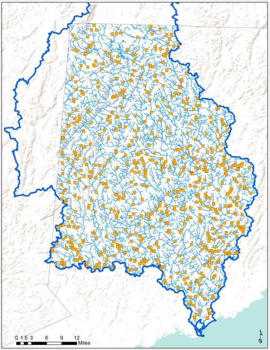
") The North Atlantic Aquatic Connectivity Collaborative (NAACC) Evaluating Road-Stream Crossings Across a Thirteen-State Region Jessie Levine September 14, 2016 NETWC Scale of the Problem Data on 9,064 crossings
The North Atlantic Aquatic Connectivity Collaborative (NAACC) Evaluating Road-Stream Crossings Across a Thirteen-State Region Jessie Levine September 14, 2016 NETWC Scale of the Problem Data on 9,064 crossings
Application for resource consent Form B Damming and diversion of water
 Application for resource consent Form B Damming and diversion of water Notes Resource use activities must meet all the conditions of any relevant Permitted Activity Rules in the Waikato Regional Plan or
Freight Street Development Strategy
 Freight Street Development Strategy Appendix B: Naugatuck River Floodplain Analysis Freight Street Development Strategy DECEMBER 2017 Page B-1 1.0 NAUGATUCK RIVER FLOODPLAIN AT FREIGHT STREET 1.1 Watershed
Conceptual Design and Feasibility of a Natural Fishway at the Fremont BART Weir, Alameda Creek, California
 Conceptual Design and Feasibility of a Natural Fishway at the Fremont BART Weir, Alameda Creek, California Final Report September 2005 Prepared by Center for Ecosystem Management and Restoration, Oakland,
APPENDIX G DIVERSION AND PELICAN LAKE CUTOFF CHANNELS HYRAULICS AND BRIDGE TECHNICAL MEMORANDUM
 APPENDIX G DIVERSION AND PELICAN LAKE CUTOFF CHANNELS HYRAULICS AND BRIDGE TECHNICAL MEMORANDUM To: File Memo From: Matt Redington, P.E. Project: Watertown South Connector CC: Date: March 6, 2007; revised
ILLINOIS URBAN MANUAL PRACTICE STANDARD TEMPORARY STREAM CROSSING (no.) CODE 975. Source: Hey and Associates, Inc.
 CODE 975. Source: Hey and Associates, Inc.") ILLINOIS URBAN MANUAL PRACTICE STANDARD TEMPORARY STREAM CROSSING (no.) CODE 975 Source: Hey and Associates, Inc. DEFINITION A bridge or culvert crossing installed across a stream or watercourse for short-term
ILLINOIS URBAN MANUAL PRACTICE STANDARD TEMPORARY STREAM CROSSING (no.) CODE 975 Source: Hey and Associates, Inc. DEFINITION A bridge or culvert crossing installed across a stream or watercourse for short-term
Climate Change Resilience and the Vermont Agency of Transportation
 Climate Change Resilience and the Vermont Agency of Transportation Gina Campoli, Environmental Policy Manager Vermont Agency of Transportation Flooding, Vulnerability and Risk Oh My! AASHTO s 21 st Century
INDIAN CREEK WATERSHED PLAN EXECUTIVE SUMMARY
 INDIAN CREEK WATERSHED PLAN EXECUTIVE SUMMARY The Indian Creek Watershed covers a 38 square mile area in southern Lake County, Illinois that drains 24,116 acres before discharging into the Des Plaines
Preparing for the Storms: Municipal Adaptation for Climate Change Resiliency
 Preparing for the Storms: Municipal Adaptation for Climate Change Resiliency Massachusetts Association of Planning Directors Annual Conference UMass Lowell Inn and Conference Center June 6, 2013 E. Heidi
A Hydrologic Study of the. Ryerson Creek Watershed
 A Hydrologic Study of the Ryerson Creek Watershed Dave Fongers Hydrologic Studies Unit Land and Water Management Division Michigan Department of Environmental Quality May 8, 2002 Table of Contents Summary...2
Culvert Prioritization Model: Aiding Communities in the Selection of Priority Restoration Projects
 Culvert Prioritization Model: Aiding Communities in the Selection of Priority Restoration Projects Meeting #1 of the Technical Advisory Committee March 18, 2016 1 Press 2 Prepared February 2016 Undersized
Wood-Pawcatuck Watershed Flood Resiliency Management Plan
 Wood-Pawcatuck Watershed Flood Resiliency Management Plan Project Steering Committee Kickoff Meeting March 26, 2015 Wood-Pawcatuck Watershed Association Meeting Agenda 10:00 10:05 Welcome and Opening Remarks
RETENTION BASIN EXAMPLE
 -7 Given: Total Tributary Area = 7.5 ac o Tributary Area within Existing R/W = 5.8 ac o Tributary Area, Impervious, Outside of R/W = 0.0 ac o Tributary Area, Pervious, Outside of R/W = 1.7 ac o Tributary
COTTON CREEK CULVERT REPLACMENT
 COTTON CREEK CULVERT REPLACMENT Integrating Mobility with Environmental Innovation Located along a scenic section of Highway 3/95 in British Columbia, Moyie Bluffs, a 6.5 km stretch of inland highway had
Gwinnett County Dept. of Water Resources Watershed Improvement Program. Russell Manley, CFM, Gwinnett County DWR Kevin Middlebrooks, CH2M
 Gwinnett County Dept. of Water Resources Watershed Improvement Program Russell Manley, CFM, Gwinnett County DWR Kevin Middlebrooks, CH2M Gwinnett County: Population: 859,000 Area: 437 sq. miles 2,000 miles
Aquatic Resource Mitigation Fund
 Aquatic Resource Mitigation Fund Lori Sommer- Mitigation Program Coordinator Land Resource Management Program NH Department of Environmental Services PRESENTATION OVERVIEW Brief overview on mitigation
Session C7- Building on the $10 million/year H TAP program for culvert mitigation on national forest system lands
 University of Massachusetts - Amherst ScholarWorks@UMass Amherst International Conference on Engineering and Ecohydrology for Fish Passage International Conference on Engineering and Ecohydrology for Fish
Rascal Goose. Reach 1. Rascal Goose. Reach 2. å å å. Main Goose Pit. Stream Reach 3. Main Goose Pit. Stream Reach 7
 434000 March 16 2014 434200 434400 ± 434600 434800 435000 Goose Lake 7269800 WRSA B 7269800 7270000 433800 GIS # BAC-06-180a 7270000 PROJECT # 0234411-0005 Rascal Goose Reach 1 Main Goose Pit Stream Reach
E. STORMWATER MANAGEMENT
 E. STORMWATER MANAGEMENT 1. Existing Conditions The Project Site is located within the Lower Hudson Watershed. According to the New York State Department of Environmental Conservation (NYSDEC), Lower Hudson
Section 6: Stormwater Improvements
 Section 6: Stormwater Improvements A major objective of this study was to identify opportunities for improvements to address the widespread water quality impairments caused by stormwater runoff in the
Stream Crossing Reconstruction on the Bog Dam Loop Road (FR15) Scoping Notice. Androscoggin Ranger District
 Scoping Notice. Androscoggin Ranger District") United States Department of Agriculture Forest Service White Mountain National Forest Stream Crossing Reconstruction on the Bog Dam Loop Road (FR15) Scoping Notice Androscoggin Ranger District Androscoggin
United States Department of Agriculture Forest Service White Mountain National Forest Stream Crossing Reconstruction on the Bog Dam Loop Road (FR15) Scoping Notice Androscoggin Ranger District Androscoggin
Errata sheet for the Connecticut General Permits May 2, 2017
 Errata sheet for the Connecticut General Permits May 2, 2017 The Corps of Engineers, New England District, has compiled this list of corrections and clarifications for the Connecticut General Permits that
The RI River and Stream Continuity Project. Follow Up Meeting. April 18, 2007
 The RI River and Stream Continuity Project Follow Up Meeting April 18, 2007 Project Partners Purpose of the Meeting To present methods to evaluate culverts as potential barriers. To demonstrate how data
PROJECT SCOPE OF WORK CITY OF TOWN AND COUNTRY STORMWATER PROGRAM
 PROJECT SCOPE OF WORK CITY OF TOWN AND COUNTRY STORMWATER PROGRAM Project Name: 1338 Thornhill Dr Project ID Number: 1-3 Problem: Creek bank erosion is occurring along from the northern property line at
South St. Vrain / Hall Meadows Restoration Planning August 20, 2015
 South St. Vrain / Hall Meadows Restoration Planning August 20, 2015 Agenda Introductions Purpose & Goals of Meeting Planning Area Master Plan Restoration Planning: Cost Estimates, Grants, Scope, Timeline
LITTLE SHADES CREEK RESTORATION PROJECT CWA Section 319(h) Nonpoint Source Implementation Grant Project Workplan #17 ADEM Contract #C
 Nonpoint Source Implementation Grant Project Workplan #17 ADEM Contract #C") LITTLE SHADES CREEK RESTORATION PROJECT CWA Section 319(h) Nonpoint Source Implementation Grant Project Workplan #17 ADEM Contract #C90593066 PARTNERS Alabama Department of Environmental Management Cawaco
LITTLE SHADES CREEK RESTORATION PROJECT CWA Section 319(h) Nonpoint Source Implementation Grant Project Workplan #17 ADEM Contract #C90593066 PARTNERS Alabama Department of Environmental Management Cawaco
Appendix B Stormwater Site Plan Submittal Requirements Checklist
 Stormwater Site Plan Submittal Requirements Checklist The Submittal Requirements Checklist is intended to aid the design engineer in preparing a Stormwater Site Plan. All items included in the following
EFFECT OF UPSTREAM DEVELOPMENT ON THE CLEAR CREEK AREA
 EFFECT OF UPSTREAM DEVELOPMENT ON THE CLEAR CREEK AREA Technical Memorandum Farming in the Floodplain Project Prepared for May 2017 PCC Farmland Trust Photo credit: Google Earth TABLE OF CONTENTS Page
STORM DRAINAGE DESIGN MANUAL
 Appendix I STORM DRAINAGE DESIGN MANUAL by: SUNGATE DESIGN GROUP, P.A. GEN ERAL DESIGN STAN DARDS AN D POLICIES 1. STREET AND LOCAL DRAINAGE Discharge estimates for specified design storms shall be calculated
In re: Town of Norwich Pool Dam Reconstruction, Stream Alteration Permit Application
 Agency of Natural Resources October 20, 2015 Neil R. Fulton Town Manager Town of Norwich P.O. Box 376 Norwich, VT 05055 In re: Town of Norwich Pool Dam Reconstruction, Stream Alteration Permit Application
Watershed Hydrology: Go with the flow. Greg Jennings, PhD, PE
 Watershed Hydrology: Go with the flow Greg Jennings, PhD, PE jenningsenv@gmail.com Streams What are your CHALLENGES? Hydrology too much water Pollutants upstream and on-site Vegetation wrong plants, wrong
Case Study 5. Willow Creek Concrete Plank Ford
 Appendix A Case Study Case Study. Willow Creek Concrete Plank Ford Location Northeastern California. Plumas National Forest. Willow Creek. miles northwest of Portola, CA, on Spur Road 23N97Y off Forest
Case Study 12. Grubbs Concrete Slab Vented Ford
 Appendix A Case Study Case Study. Grubbs Concrete Slab Vented Ford Location North central California. Plumas National Forest. Mount Hough Ranger District. Grizzly Creek. 3 miles west of Bucks Lake, CA.
Rainfall, runoff and sediment transport in the Napa River watershed: now and a possible future
 Rainfall, runoff and sediment transport in the Napa River watershed: now and a possible future Lester McKee San Francisco Estuary Institute 5/24/2017 1 The importance of the natural water cycle of infiltration
Errata sheet for the Connecticut General Permits March 26, 2019
 Errata sheet for the Connecticut General Permits March 26, 2019 The Corps of Engineers, New England District, has compiled this list of corrections and clarifications for the Connecticut General Permits
Culvert Prioritization Model: Aiding Communities in the Selection of Priority Restoration Projects
 Culvert Prioritization Model: Aiding Communities in the Selection of Priority Restoration Projects SNHPC Meeting January 24, 2017 1 Undersized Culverts! Culvert Sizes (~7,500 VT culverts) 6,000 5,000 69%
Climate Change: Impacts, Monitoring, and Solutions
 Climate Change: Impacts, Monitoring, and Solutions 1 Responding to Climate Change 1. Projections/Impacts 2. Adaptation and Resiliency 3. Monitoring 4. What about emissions? 2 Native trout and salmon are
Jacobi, Toombs, and Lanz, Inc.
 Area 5: Blackiston Mill Road at Dead Man's Hollow Flooding Assessment Jacobi, Toombs, and Lanz, Inc. This document summarizes an assessment of drainage and flooding concerns and provides recommendations
Gwinnett County Capital Improvement Planning Utilizing Floodplain Models
 Gwinnett County Capital Improvement Planning Utilizing Floodplain Models Jonathan Semerjian, PE Dept. of Water Resources Stormwater Management Clay Daniel, CFM Dewberry Seyoum Asamenaw, PE Dewberry Gwinnett
Community Benefits of Land Restoration
 Community Benefits of Land Restoration Introducing Green Infrastructure for Coastal Resilience Matt Fulda, Acting Director Monroe May 23 rd, 2017 Avery Point Campus, University of Connecticut Easton Trumbull
BCWMC Capital Improvement Program (approved April 19, 2018; pending minor Plan amendment)
") BCWMC Capital Improvement Program 2020 2024 (approved April 19, 2018; pending minor Plan amendment) Project Name City Number 2019 2020 2021 2022 2023 2024 2025 Totals Medicine Lake Rd and Winnetka Ave
BCWMC Capital Improvement Program 2020 2024 (approved April 19, 2018; pending minor Plan amendment) Project Name City Number 2019 2020 2021 2022 2023 2024 2025 Totals Medicine Lake Rd and Winnetka Ave
PEARCE CREEK CONFINED DISPOSAL AREA MODIFICATION
 US Army Corps of Engineers Philadelphia District PEARCE CREEK CONFINED DISPOSAL AREA MODIFICATION CECIL COUNTY MARYLAND STORMWATER MANAGEMENT PLAN NARRATIVE INITIAL SUBMISSION JUNE 2014 1 PEARCE CREEK
Krista Reininga, PE Hydromodification and What it Means for the Design of Stormwater Facilities
 Krista Reininga, PE Hydromodification and What it Means for the Design of Stormwater Facilities Agenda 1. Evolution of Water Quality Facilities 2. Regulatory Response/MS4 Permit Requirements 3. Change
CROSBY BROOK RESTORATION STUDY BRATTLEBORO, VT
 Key Stakeholders: CROSBY BROOK RESTORATION STUDY BRATTLEBORO, VT Funded By: VT Dept. of Environmental Conservation VT Agency of Transportation (VTrans) Town of Brattleboro NEWEA Spring Meeting Omni Mt.
PROJECT SCREENING MATRIX: A User s Guide
 Version 2.0 Page 1 of 7 November 9, 2010 PROJECT SCREENING MATRIX: A User s Guide BACKGROUND The Project Screening Matrix (Screening Matrix) is one of several tools that comprise the River Restoration
Hazard Mitigation and Adaptation to Climate Change
 Hazard Mitigation and Adaptation to Climate Change Citizen Planner Training Conference Holy Cross College, Worcester March 16, 2013 E. Heidi Ricci Senior Policy Analyst Mass Audubon Thanks to Scott Horsley,
Lyon Creek Cedar Way Stormwater Detention Dam Operation and Maintenance Manual
 Lyon Creek Cedar Way Stormwater Detention Dam Operation and Maintenance Manual Prepared by: Mike Shaw Stormwater Program Manager City of Mountlake Terrace January 2010 Section I General Information This
Glossary of Terms. Aquifer A permeable body of rock capable of yielding quantities of groundwater to wells and springs.
 Glossary of Terms 100-year flood A large, but infrequent, flood event that has a 1% chance of occurring in any given year (occurs, on average, once every 100 years). 100-year floodplain Areas adjacent
Town of Aurora Stream Management Master Plan PUBLIC INFORMATION CENTRE May 1 st, 2018
 Town of Aurora Stream Management Master Plan PUBLIC INFORMATION CENTRE May 1 st, 2018 Your comments are encouraged and appreciated, as this will provide us an opportunity to address project issues and
MUNICIPAL CLIMATE ADAPTATION GUIDANCE SERIES
 MUNICIPAL CLIMATE ADAPTATION GUIDANCE SERIES MUNICIPAL CLIMATE ADAPTATION GUIDANCE SERIES SECTIONS OVERVIEW Blue Sky Planning Solutions TRANSPORTATION Joel Greenwood, Kennebec Valley Council of Governments
Maine Department of Environmental Protection (DEP)
") Maine Department of Environmental Protection (DEP) By Cameron Adams Southern Maine Region 312 Canco Road, Portland (207)822-6300 Main Office and Central Maine Region 28 Tyson Drive, Augusta (207)287-7688
Maine Department of Environmental Protection (DEP) By Cameron Adams Southern Maine Region 312 Canco Road, Portland (207)822-6300 Main Office and Central Maine Region 28 Tyson Drive, Augusta (207)287-7688
Chapter 11 Culverts and Bridges
 Chapter 11 Culverts and Bridges Contents 1.0 Introduction... 1 2.0 General Design... 1 2.1 Design Criteria... 1 2.2 Design Flows... 1 2.3 Permitting and Regulations... 1 2.4 Aesthetics and Safety... 2
Water and Watersheds. Data Maps Action
 Water and Watersheds Data Maps Action What is the Wildlife Action Plan? Restore rare wildlife and habitats. Keep common species common. 2015 Revision: Partners in Conservation Science 2015 Revision Data
BCWMC Capital Improvement Program (Approved with Minor Plan Amendment July 2017)
") BCWMC Capital Improvement Program 2019 2023 (Approved with Minor Plan Amendment July 2017) Project Name City Number 2016 2017 2018 2019 2020 2021 2022 2023 Totals Honeywell Pond Expansion, Main Stem Watershed
BCWMC Capital Improvement Program 2019 2023 (Approved with Minor Plan Amendment July 2017) Project Name City Number 2016 2017 2018 2019 2020 2021 2022 2023 Totals Honeywell Pond Expansion, Main Stem Watershed
STREAM RESTORATION PURPOSE, PRACTICE, AND METHODS. By Marcus Rubenstein, CPESC
 STREAM RESTORATION PURPOSE, PRACTICE, AND METHODS By Marcus Rubenstein, CPESC WHAT IS STREAM RESTORATION? The return of a stream s lost natural functions, usually resulting from watershed alterations,
Central Washington 2012 Wildfires Burned Area Emergency Response (BAER) Information Brief October 19, 2012 BAER Information: (208)
 Information Brief October 19, 2012 BAER Information: (208)") Okanogan-Wenatchee National Forest Central Washington 2012 Wildfires Burned Area Emergency Response (BAER) Information Brief October 19, 2012 BAER Information: (208) 398-3348 Fire Background WENATCHEE
Okanogan-Wenatchee National Forest Central Washington 2012 Wildfires Burned Area Emergency Response (BAER) Information Brief October 19, 2012 BAER Information: (208) 398-3348 Fire Background WENATCHEE
BAEN 673 / February 18, 2016 Hydrologic Processes
 BAEN 673 / February 18, 2016 Hydrologic Processes Assignment: HW#7 Next class lecture in AEPM 104 Today s topics SWAT exercise #2 The SWAT model review paper Hydrologic processes The Hydrologic Processes
Temporary Watercourse Crossing: Culverts
 Temporary Watercourse Crossing: Culverts DRAINAGE CONTROL TECHNIQUE Low Gradient Velocity Control Short Term Steep Gradient Channel Lining Medium-Long Term Outlet Control Soil Treatment Permanent Symbol
Vermillion River Headwaters Groundwater Recharge Area Inventory and Protection Plan
 Vermillion River Headwaters Groundwater Recharge Area Inventory and Protection Plan A project funded through a Metro Environmental Partnership grant from the Metropolitan Council with technical analysis
Bluff Creek One Water
 Bluff Creek One Water The Bluff Creek Watershed has no lakes within its boundaries. As the westernmost watershed within the District, land use changes from agricultural to residential have occurred relatively
S.R. 4007, Section 14B PADEP Environmental Assessment Form. Enclosure C Description of Aquatic Habitat
 S.R. 4007, Section 14B PADEP Environmental Assessment Form Description of Aquatic Habitat Cresheim Creek is the only water resource that exists within the project area. No jurisdictional wetlands were
The Texas A&M University and U.S. Bureau of Reclamation Hydrologic Modeling Inventory (HMI) Questionnaire
 Questionnaire") The Texas A&M University and U.S. Bureau of Reclamation Hydrologic Modeling Inventory (HMI) Questionnaire May 4, 2010 Name of Model, Date, Version Number Dynamic Watershed Simulation Model (DWSM) 2002
The Texas A&M University and U.S. Bureau of Reclamation Hydrologic Modeling Inventory (HMI) Questionnaire May 4, 2010 Name of Model, Date, Version Number Dynamic Watershed Simulation Model (DWSM) 2002
Highway Drainage 1- Storm Frequency and Runoff 1.1- Runoff Determination
 Highway Drainage Proper drainage is a very important consideration in design of a highway. Inadequate drainage facilities can lead to premature deterioration of the highway and the development of adverse
Municipal Stormwater Management Plan Prepared For The Borough of Cape May Point By Van Note-Harvey Associates VNH File No.
 Municipal Stormwater Management Plan Prepared For The Borough of Cape May Point By Van Note-Harvey Associates 2005 VNH File No. 35317-210-21 Table of Contents Introduction... 3 Goals... 3 Storm water Discussion...
Stream Restoration at Road Crossings in Northern Wisconsin. Dale Higgins, USDA Forest Service
 Stream Restoration at Road Crossings in Northern Wisconsin Dale Higgins, USDA Forest Service Key Points Large # of road and trail stream crossings on the landscape Many crossings adversely impact streams
4. Present Activities and Roles
 4. Present Activities and Roles The present missions, authorities, activities and roles of the various agencies involved with flood protection, floodplain management and flood-damage reduction are identified
Hydromodification Management Measures
 Chapter 7 Hydromodification Management Measures This Chapter summarizes the requirements for controlling erosive flows from development projects. 7.1 Why Require Hydromodification Management? Changes in
Hydromodification Management Measures
 Chapter 7 Hydromodification Management Measures This Chapter summarizes the requirements for controlling erosive flows from development projects. 7.1 Why Require Hydromodification Management? Changes in
5.0 SURFACE WATER CONTROL MEASURES
 5.0 SURFACE WATER CONTROL MEASURES After performing the analysis summarized above, Burns & McDonnell civil engineers, construction personnel, and environmental personnel walked both Newgate/Phelps Road
UMLALAZI-NKANDLA SMART GROWTH DEVELOPMENT CENTRE PROVISION OF CIVIL ENGINEERING SERVICES
 UMLALAZI-NKANDLA SMART GROWTH DEVELOPMENT CENTRE PROVISION OF CIVIL ENGINEERING SERVICES PROPOSED STORMWATER RETICULATION DESIGN AND MANAGEMENT DATE: OCTOBER 2011 PREPARED FOR: PREPARED BY: DEPARTMENT
APPENDIX E APPENDIX E ESTIMATING RUNOFF FOR SMALL WATERSHEDS
 APPENDIX E ESTIMATING RUNOFF FOR SMALL WATERSHEDS March 18, 2003 This page left blank intentionally. March 18, 2003 TABLES Table E.1 Table E.2 Return Frequencies for Roadway Drainage Design Rational Method
SHORELINE INVENTORY AND RESTORATION PLANNING
 CHAPTER 3 SHORELINE INVENTORY AND RESTORATION PLANNING A. PURPOSE OF THE SHORELINE INVENTORY AND CHARACTERIZATION A first step in the comprehensive Master Program update process is development of a shoreline
Primer introduction to watershed management Plan Process highlight the major steps of plan development Project types look at some examples of common
 1 Primer introduction to watershed management Plan Process highlight the major steps of plan development Project types look at some examples of common projects Plan Organization how to read the plan Next
Climate Ready Culverts. Funding
 Climate Ready Culverts Thomas P. Ballestero University of New Hampshire Stormwater Center 2016 INAFSM Annual Conference Florence, IN 7 9 Sep 2016 1 Funding 2 1 Culvert Hydraulics 3 Bridge Versus Culvert
Case Studies in Hazard Class Reductions Implementation of NY s Guidance for Dam Hazard Classification
 Case Studies in Hazard Class Reductions Implementation of NY s Guidance for Dam Hazard Classification Gregory J Daviero, PhD, PE, Principal Kevin Ruswick, PE, CFM, Associate May 2, 2014 Schnabel Engineering
Geneva Dam. Design of a Steep, Temporary, Riprap Ramp
 Geneva Dam Design of a Steep, Temporary, Riprap Ramp A Run-of of-river Dam Analysis for Geneva Dam Credit to: Yu-Chun Su, Ph.D., P.E., CFM David T. Williams. Ph.D., P.E, CFM Presentation Purpose History
IMPROVING OUTCOMES FOR STREAM ALTERATION PROJECTS
 IMPROVING OUTCOMES FOR STREAM ALTERATION PROJECTS Bethany Matousek Inland Lakes and Streams Program Coordinator Wetlands, Lakes and Streams Unit DEQ Water Resources Division MatousekB@Michigan.gov 517-243-6421
Climate Change: What It Means for Transportation Infrastructure
 Climate Change: What It Means for Transportation Infrastructure Tropical Storm Irene Great Flood of 2010 Michael P. Lewis RIDOT Director AASHTO President Hurricane Sandy The Issues for Rhode Island Sea
Information for File # MVP SJW
 Information for File # MVP-2018-02581-SJW Applicant: Robert Kiszka Fairview Cranberry Co., LLC Corps Contact: Sam Woboril Address: 2926 Post Road, Suite B, Stevens Point, Wisconsin 54481 E-Mail: samuel.j.woboril@usace.army.mil
Thanks to Bill Elliot, Research Leader U.S. Department of Agriculture Forest Service
 Thanks to Bill Elliot, Research Leader U.S. Department of Agriculture Forest Service To present an overview Forest Soil Erosion Processes 2 Precipitation or melting snow Evapotranspiration Infiltration
LOCATION AND DESIGN DIVISION
 VIRGINIA DEPARTMENT OF TRANSPORTATION LOCATION AND DESIGN DIVISION INSTRUCTIONAL AND INFORMATIONAL MEMORANDUM GENERAL SUBJECT: CULVERT DESIGN SPECIFIC SUBJECT: COUNTERSINKING AND LOW FLOW CONSIDERATIONS
Use of WARSSS in Stream Restoration and Watershed Planning. Michigan Aquatic Restoration Conference 2015
 Use of WARSSS in Stream Restoration and Watershed Planning Michigan Aquatic Restoration Conference 2015 October 22, 2015 Use of WARSSS in Stream Restoration and Watershed Planning 1. Watershed Management
5.2-2 Progress Report and Future Outlook
 5.2-2 Progress Report and Future Outlook Presentation to Peel Regional Council By Deborah Martin-Downs June 22, 2017 5.2-3 Outline 2016 Highlights and 2017 Accomplishments to Date Climate Risk Methodology