Woody Debris Management
|
|
|
- Kerry Douglas
- 5 years ago
- Views:
Transcription

1 Woody Debris Management How I Learned to Stop Worrying and Love the Log Jam Matthew R. Best, M.S. Drains Manager Facilities Management Division Wayne County Department of Public Services


2 Contributors William Craig, President, Holliday Nature Preserve Noel Mullett Jr., Rouge Technical Coordinator, Wayne County Department of Environment Sally Petrella and Cyndi Ross, Friends of the Rouge Joseph Rathbun, Water Quality Analyst, Michigan Department of Environmental Quality Marty Boote and Tonya Hunter, Engineers, ECT. Assisted by the members of the Riparian Corridor Management Technical Advisory Committee Ken Kucel and Elmeka Steele, Wayne County Drain Office
3 Where we were


4 Urban/suburban logjams seen as significant problem Removal of logjams thought to be solution In Rouge Watershed, logjams have been removed for years B. Craig

5 Rouge Remedial Action Plan RAP Finding: 1992 Annual Progress Report Variable river flows, logjams and debris contribute to degraded fish habitat aesthetics and recreational opportunities. Actions: Since 1986, the Friends of the Rouge have organized an annual clean up of the Rouge River, known as the "Rouge Rescue". Over the past seven years, nearly 15,000 volunteers have removed over 19,000 cubic yards of debris, including approximately 500 log jams. At least 20 communities conduct regular cleanups of the river, removing logjams and other debris, both as part of the Rouge Rescue and on their own throughout the year. Detroit, for example, removes debris several times each year.

6


7 Urban/Suburban Logjams/Woody Debris Erosion Loss of Private Property Aesthetics Perceived Problems Expense of removal vs. expense of leaving in place Balance benefits of management vs. removal

8 And a crayfish jumped

9 Looked at what George Palmiter did in 1975 and on. Looked at what MDEQ was doing on trout streams in Northern Michigan to improve habitat. Looked at similar applications in the Pacific Northwest The same concepts could work in an URBAN watershed for habitat AND stabilization benefits.
10 Our understanding of the river and it s structure had changed.
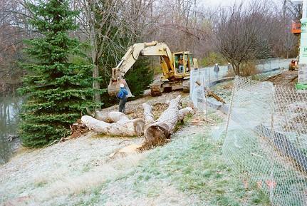
11 Holliday Nature Preserve Rouge Rescue 1998

12

13

14

15
16 Real Change In 2001, an internal policy shift at MDEQ now required a permit for activities inside high water mark, that breaks banks, bottom or affixes structure. Logjam removal (the main River Day activity) would require a permit. New methods for dealing with logjams were needed to continue river day activities.

17 Woody Debris Management Most Log Jams are GOOD! Cheaper to manage log jams and other woody debris that just ripping them out of the river Benefits of Woody Debris Management Saves money and buys time Habitat Creation/Preservation Bank Protection Flood Alleviation Not Illegal!

18 Methods Clean and Open Method Habitat and Bank Protection Method Engineered Structure Method


19 Evaluate logjams/woody debris by Size Current in-situ Thalweg position Soil type Safety Time From this evaluation, look for potential impacts from Removal Leaving in place Opening center
20 Clean and Open Criteria Must have a logjam/woody debris that is obstructing river flow No potential impact to human health/private property at location Logs are of manageable size


21 Clean and Open Method 1. CLEAN- Urban rubbish is removed or cleaned 2. OPEN- Center of logjam is opened at center of stream flow (thalweg) 3. Opening size determined by stream morphology and flow. M. Best
 Friends of the Rouge/Canton")
22 Clean and Open Method (cont.) Friends of the Rouge/Canton Township
 Woody debris that is embedded in streambank")

23 Clean and Open Method (cont.) Woody debris that is embedded in streambank or bottom is not removed. The opening in the logjam can be done with the use of handsaw or chainsaw Done by Hand


24 Benefits of Clean and Open Method Does not need a MDEQ permit. Creates, preserves and enhances fish, aquatic invertebrate and wildlife habitat structure Reduces localized flooding and erosion while maintaining flow reduction and sediment deposition benefits Directing the flow through the logjam and the new opening, instead of around the sides of the logjam. Increases/maintains the river s aesthetic value
25 Benefits of Clean and Open Method (cont.) Meets regulatory requirements. (SWPPI, SW General Permit) Habitat Creation/Enhancement Preserving riparian vegetation Inexpensive approach that saves money
26 Clean and Open Implementation The clean and open method has been directly applied at 6 sites in the implementation area. It also has been applied by NGO volunteers at over 40 sites over last 4 yrs (Rouge Rescue) These sites have maintained healthy, clear channels and woody debris has not reconstituted into a problem at these locations. Monitoring at these location is ongoing, specifically looking at erosion rates, aesthetics and benthic communities.

27 Nankin Mills WDM 101

28 2004


29 2007
30 Holliday Nature Preserve Rouge Rescue 2000

31

32

33

34

35

36

37
38 What about areas in the river that need Habitat structure Bank protection from erosive, flashy flows

39 Habitat and Bank Protection Criteria Area of occurring or potential streambank erosion and/or... Area that needs habitat structure Woody debris has the ability to be cabled securely to the bank Cabling logs to the bank will not completely obstruct river flow Debris placement has no foreseeable, potential impact to human health/private property at location
40 City of Wayne Woody Debris Management

41

42 B. Craig

43
44

45


46 Habitat Structure Method 1. PERMIT - Secure approved permit for project from MDEQ. 2. MOVE- Move or place selected woody debris in optimum position. 3. SECURE - Attach woody debris to bank by using cable and post or chain.

47

48 B. Craig
49 Data from Joe Rathbun

50 Data and Photo from Joe Rathbun


51 Benefits of Habitat and Bank Protection Method Creates, preserves and enhances fish and wildlife habitat Reduces localized flooding and erosion while maintaining flow reduction and sediment deposition benefits. A River Runs Through It Meets regulatory requirements. Inexpensive! Remember that these are only temporary placements.

52
53 Engineered Structure Criteria Area of occurring or potential streambank erosion and/or... Area that needs habitat structure Woody debris has the ability to be cabled securely to the bank Cabling logs to the bank will not completely obstruct river flow Debris placement MAY HAVE a foreseeable, potential impact to human health/private property at location

54 Wayne County Woody Debris Management

55

56
57
58

59

60

61

62

63

64

65
66 Remember A recent study documented in their control section of stream which received large woody debris due to a storm did not see an increase in trout numbers and sizes. This suggests that the addition of cover by itself doesn t have much benefit. It is strategic placement of structure that increases the depth and quality of pool habitat and makes the most difference.
67 Where we are going.
68 Solution Recognize and ACCEPT that logjams are part of the natural process Logjams are one of the ways that rivers adapt to land changes. Changes to the land accelerate the processes that cause logjams to occur at unnatural levels. Logjams, bank erosion and flooding are symptoms rather than the true cause of problems. Usually, the amount and velocity/energy in the water is the problem.

69 Progress WE MUST CHANGE Change in philosophy takes time and proof that method does what we say it does A culture change is beginning to take place in implementation areas. Looking at logjams and other woody debris as a valuable resource and part of healthy river system, not as a problem to be removed.

70 Lessons Learned Economic and Environmental Benefits These methods do not work on every logjams or situation. Sometimes traditional engineered methods are solution Methods used here are not permanent fixes, temporary band-aids, requires routine maintenance. (It s a management system.) Initial and Yearly maintenance activity instills river stewardship from participants Must be implemented with a educational component for participants. It will take time to see the long term benefits at a regional level.

71 Future plans TAKE ADVANTAGE OF EAB Continued monitoring on existing and new sites. Continue implementation to try to change years of past practices Building woody debris management capacity at local level. (Municipalities) Implement at a regional level.


72 Questions Riparian Corridor Management Technical Advisory Committee This presentation was developed as part of the Rouge River National Wet Weather Demonstration Project, which is funded, in part, by the United States Environmental Protection Agency grant # x , -03, -04.

73
Grand Traverse Bay Watershed Protection Plan:
 Grand Traverse Bay Watershed Protection Plan: An Overview Sarah U Ren Program Director The Watershed Center 231-935-1514, suren@gtbay.org The Grand Traverse Bay Watershed 973 square miles Bay Volume =
Habitat Grant Projects Clinton River Watershed
 Habitat Grant Projects Clinton River Watershed L Y N N E S E Y M O U R E N V I R O N M E N T A L E N G I N E E R O F F I C E O F T H E M A C O M B C O U N T Y P U B L I C W O R K S C O M M I S S I O N
719 Griswold, Suite 820 Detroit, MI DANVERS POND DAM REMOVAL AND STREAM RESTORATION PROJECT
 Great Lakes Restoration Initiative Grant Final Report US EPA Grant GL 00E006 43 October, 2013 Valley Woods Wetland Southfield Lola Valley Grow Zone Wayne County Parks Venoy Park Grow Zone Wayne County
Rouge River Watershed Management Plan. To ensure that all interested stakeholders can review and comment on the
 Introduction The public participation plan for this watershed management plan was created in early 2008 and can be found on the ARC website. A number of factors were considered when developing the process.
Prepared by: Rouge River Advisory Council
 Rouge River Watershed Great Lakes Area of Concern Beneficial Use Impairment 2013 Report Card Prepared by: Rouge River Advisory Council Dear Rouge River Watershed Stakeholder: The Rouge River watershed
MONTEREY PENINSULA WATER MANAGEMENT DISTRICT PROJECT DESCRIPTION FOR SELECTIVE VEGETATION MANAGEMENT AND BANK RESTORATION (RANCHO SAN CARLOS AREA)
") MONTEREY PENINSULA WATER MANAGEMENT DISTRICT PROJECT DESCRIPTION FOR SELECTIVE VEGETATION MANAGEMENT AND BANK RESTORATION (RANCHO SAN CARLOS AREA) IN THE CARMEL RIVER CHANNEL, SUMMER AND FALL 2014 SELECTIVE
MONTEREY PENINSULA WATER MANAGEMENT DISTRICT PROJECT DESCRIPTION FOR SELECTIVE VEGETATION MANAGEMENT AND BANK RESTORATION (RANCHO SAN CARLOS AREA) IN THE CARMEL RIVER CHANNEL, SUMMER AND FALL 2014 SELECTIVE
Grand Traverse Bay Watershed Protection Plan:
 Grand Traverse Bay Watershed Protection Plan: An Overview Sarah U Ren Program Director The Watershed Center 231-935-1514, suren@gtbay.org What is a Watershed? A watershed is an area of land that captures
[] The Red Cedar River and its Streams (Fall 2001)
![[] The Red Cedar River and its Streams (Fall 2001)](/thumbs/81/84582489.jpg "[] The Red Cedar River and its Streams (Fall 2001)") [] The Red Cedar River and its Streams (Fall 2001) This is an opportunity for you to provide information for local water resource planning. Your input will help planners make informed water quality decisions.
[] The Red Cedar River and its Streams (Fall 2001) This is an opportunity for you to provide information for local water resource planning. Your input will help planners make informed water quality decisions.
SECTION 5.4 LOGJAM REMOVAL AND RIVER RESTORATION
 SECTION 5.4 LOGJAM REMOVAL AND RIVER RESTORATION Logjams restrict the flow and conveyance of natural streams and ditches which can cause increased flooding, destruction of property and wildlife habitat,
9. Evaluation Mechanisms
 9. Evaluation Mechanisms Not everything that can be counted counts, and not everything that counts can be counted. - Albert Einstein Introduction Watershed planning is meant to be an iterative process
How is Water Quality Affected by Land Use?
 Watershed Connections Lesson Les4 3 How is Water Quality Affected by Land Use? Overview What are the benefits of a healthy watershed? What are examples of land uses? What types of pollution can come from
Riparian Areas. 101 An overview. Prepared by: Jacque Sorensen, M.Sc. TRU Department of Natural Resource Sciences
 Riparian Areas 101 An overview Prepared by: Jacque Sorensen, M.Sc. TRU Department of Natural Resource Sciences February 11, 2015 Presented for the Gardom Lake Planning Committee Today s focus Riparian
Regional Stormwater Management Plan for Troy Brook, Morris County, New Jersey
 Regional Stormwater Management Plan for Troy Brook, Morris County, New Jersey Executive Summary Troy Brook is in the Whippany River watershed, which has the first TMDL in the State of New Jersey, for fecal
Massachusetts River and Stream Crossing Standards: Technical Guidelines
 Massachusetts River and Stream Crossing Standards: Technical Guidelines August 6, 2004 INTRODUCTION As long and linear ecosystems, rivers and streams are very important for fish and other wildlife movements,
ROUGE RIVER COLLABORATIVE TOTAL MAXIMUM DAILY LOAD (TMDL) IMPLEMENTATION PLAN FOR MUNICIPAL STORMWATER PERMITEES
 IMPLEMENTATION PLAN FOR MUNICIPAL STORMWATER PERMITEES") APPENDIX I ROUGE RIVER COLLABORATIVE TOTAL MAXIMUM DAILY LOAD (TMDL) IMPLEMENTATION PLAN FOR MUNICIPAL STORMWATER PERMITEES Illicit Discharge Elimination Good Housekeeping Public Education Healthier Rouge
APPENDIX I ROUGE RIVER COLLABORATIVE TOTAL MAXIMUM DAILY LOAD (TMDL) IMPLEMENTATION PLAN FOR MUNICIPAL STORMWATER PERMITEES Illicit Discharge Elimination Good Housekeeping Public Education Healthier Rouge
DEQ Update. Teresa Seidel. Director Water Resources Division
 DEQ Update Teresa Seidel Director Water Resources Division 2019 New and Old New Administration WRD Funding Priorities New Year, New Administration New Governor New Director New Structure - EGLE DEQ Water
The Importance of Riparian Forests
 The Importance of Riparian Forests By Jean Llewellyn Monroe County is the second fastest growing county in Pennsylvania. This rapid growth can be problematic because uncontrolled and unregulated growth
Local Wetland Protection in a Changing Climate. Michigan Inland Lakes Convention May 1, 2014
 Local Wetland Protection in a Changing Climate Michigan Inland Lakes Convention May 1, 2014 LIAA is a Section 501(c)3 nonprofit corporation created in 1993 to stimulate & support greater civic engagement.
Lisa Hauck Stream Restoration May
 The Effects of Stream Restoration on Habitat Quality Lisa Hauck Abstract Many stream restoration projects do not include a requirement for long-term monitoring after the project has been completed, resulting
Fraser River Water Quality
 Richmond Environmental Project Guidebook Fraser River Water Quality Why You Should Care About This Issue The Fraser River is the largest river in British Columbia. The health of the Fraser River is important
STORM WATER POLLUTION PREVENTION INITIATIVE
 STORM WATER POLLUTION PREVENTION INITIATIVE Michigan General Permit Number MIG61000 Certificate of Coverage Number MIG610038 Municipality/Agency: Plymouth Charter Township Address: 42350 Ann Arbor Road,
Agency Organization Organization Address Information. Name United States Department of Agriculture
 Logo Department Name United States Department of Agriculture Agency Organization Organization Address Information Forest Service Pacific Northwest Region 1220 SW Third Avenue (97204) P.O. Box 3623 Portland,
TMDL Report for Chesapeake Bay Shellfish Waters: Ware Creek, Taskinas Creek, and Skimino Creek Bacterial Impairments (VADEQ, 2010)
") As part of a long term commitment to environmental stewardship, James City County volunteers and staff have been gathering information about stream health throughout the County since 2008. The goal of
As part of a long term commitment to environmental stewardship, James City County volunteers and staff have been gathering information about stream health throughout the County since 2008. The goal of
Lessons Learned from the Jocko River Demonstration Project
 Lessons Learned from the Jocko River Demonstration Project Applied Adaptive Management Matt Daniels, P.E. Presentation Objectives Provide a brief overview of the project context. Describe the monitoring
Stream Watch Visual Survey Instructions
 Stream Watch Visual Survey Instructions The Stream Watch Visual Survey is based on assessment parameters from the EPA's Rapid Bioassessment Protocol Habitat Assessment, Georgia Adopt a Stream Visual Survey,
I. Welcome & Introductions WPAC History (Paul Racette, PEC)
") Poquessing Creek Watershed ACT 167 STORM WATER MANAGEMENT PLAN Public Hearing July 10, 2012 I. Welcome & Introductions ---------- WPAC History (Paul Racette, PEC) Primary WPAC Members: Bucks County: Bensalem
Poquessing Creek Watershed ACT 167 STORM WATER MANAGEMENT PLAN Public Hearing July 10, 2012 I. Welcome & Introductions ---------- WPAC History (Paul Racette, PEC) Primary WPAC Members: Bucks County: Bensalem
BMP 5.4.2: Protect /Conserve/Enhance Riparian Areas
 BMP 5.4.2: Protect /Conserve/Enhance Riparian Areas The Executive Council of the Chesapeake Bay Program defines a Riparian Forest Buffer as "an area of trees, usually accompanied by shrubs and other vegetation,
DRAFT THE ROUGE RIVER AREA OF CONCERN BENEFICIAL USE IMPAIRMENTS DELISTING STRATEGY
 DRAFT THE ROUGE RIVER AREA OF CONCERN BENEFICIAL USE IMPAIRMENTS DELISTING STRATEGY April 27, 2011 ACKNOWLEDGMENTS The Project Team (comprised of the individuals listed below) would like to acknowledge
Milwaukee River Watershed Fish Passage Program. Making Connections Across Our Watershed
 Milwaukee River Watershed Fish Passage Program Making Connections Across Our Watershed 1 Mequon Rotary Club Presentation Program Overview Making Connections Ryan McCone, Program Assistant, Ozaukee County
Ocqueoc River Watershed Management Plan update October 2008
 Ocqueoc River Watershed Management Plan update October 2008 By: Charlie Lyon, Chair-Habitat Restoration and Protection Committee, County Drain Commissioner, ex-officio member of the Commission. Re: The
Good morning, Chairman Yaw, Chairman Yudichak, Chairman Vulakovich, Chairman Costa,
 Testimony of Patrick McDonnell, Secretary Pennsylvania Department of Environmental Protection Joint Hearing on Flooding and Emergency Response Senate Environmental Resources & Energy and Veterans Affairs
RE: Recommendations for Staged Implementation of Alternative 3a
 March 10, 2006 Ms. Julie Thomas Coastal San Luis Resource Conservation District 545 Main Street, Suite B-1 Morry Bay, Ca 93442 RE: Recommendations for Staged Implementation of Alternative 3a Dear Ms. Thomas,
Stream Corridor Stewardship & Management Planning
 Stream Corridor Stewardship & Management Planning Presentation by: Shelly Johnson-Bennett, DC Planning Department Wayne Reynolds, DC Department of Public Works Purpose To enhance stream corridor stewardship
DFO s Fish Habitat Management Program
 DFO s Fish Habitat Management Program Overview Fish and Fish Habitat DFO Policy - Objectives and Goals How Do the Fisheries Act and Navigable Waters Protection Act Affect Cattle Producers Riparian Areas,
LAKE CHEMUNG GENOA TOWNSHIP LIVINGSTON COUNTY, MICHIGAN STORM DRAIN AND TRIBUTARY STUDY. Prepared for:
 LAKE CHEMUNG GENOA TOWNSHIP LIVINGSTON COUNTY, MICHIGAN STORM DRAIN AND TRIBUTARY STUDY Prepared for: Lake Chemung Riparian Association c/o 1125 Sunrise Park Drive Howell, MI 48843 Prepared by: Progressive
EXECUTIVE SUMMARY DES PLAINES RIVER WATERSHED-BASED PLAN WHY A WATERSHED-BASED PLAN? WHAT IS A WATERSHED?
 Des Plaines River Watershed-Based Plan EXECUTIVE SUMMARY June 2018 EXECUTIVE SUMMARY DES PLAINES RIVER WATERSHED-BASED PLAN WHY A WATERSHED-BASED PLAN? Water is elemental to our lives. Plants and animals,
Public Notice. Public Notice No. Date: April 8, 2016 CENAP-PL-E Comment Period Closes: May 9, 2016
 Public Notice Public Notice No. Date: April 8, 2016 CENAP-PL-E-16-02 Comment Period Closes: May 9, 2016 USACE Philadelphia District: http://www.nap.usace.army.mil COBBS CREEK FISH PASSAGE PROJECT SECTION
Issues, Concerns & Constraints
 Identifying Issues, Concerns & Constraints In order to identify the issues and concerns of watershed residents, several methods of gathering public input were employed. The Brodhead Watershed Association
Of course like all of you I live here on the Blue Planet and everyone knows the facts. 72% of the surface covered in water most of that is salt and
 1 Of course like all of you I live here on the Blue Planet and everyone knows the facts. 72% of the surface covered in water most of that is salt and so on and in some parts of the world access to fresh
RIPARIAN CORRIDOR STUDY FINAL CITY CREEK MANAGEMENT PLAN TABLE OF CONTENTS
 TABLE OF CONTENTS 1.0 INTRODUCTION... 1-1 Riparian Corridor Study and Management Plan Goals... 1-1 Study Area... 1-2 Importance and Functions of Riparian Corridors... 1-2 Habitat for Mammals, Birds, and
RIPARIAN PROTECTION Questions & Answers
 RIPARIAN PROTECTION Questions & Answers 1. What is a riparian corridor and why is it important? Answer: A riparian corridor is a space on both sides of a stream or around a lake or wetland. The corridor
THE ROUGE RIVER AREA OF CONCERN BENEFICIAL USE IMPAIRMENTS DELISTING STRATEGY
 THE ROUGE RIVER AREA OF CONCERN BENEFICIAL USE IMPAIRMENTS DELISTING STRATEGY April 27, 2011 Revised May 8, 2012 ACKNOWLEDGMENTS The Project Team (comprised of the individuals listed below) would like
EAGLE RIVER WATERSHED RESTORATION REMEDIATING 150 YEARS OF COPPER CONTAMINATION
 EAGLE RIVER WATERSHED RESTORATION REMEDIATING 150 YEARS OF COPPER CONTAMINATION Kotke, 2008 Chad Kotke Michigan Department of Environmental Quality Water Resources Division The Eagle River is exceeding
CHAPTER 4 WATERSHED PLAN GOALS & OBJECTIVES
 4.0 Introduction CHAPTER 4 WATERSHED PLAN GOALS & OBJECTIVES After the watershed analysis had been completed, the next step in the planning process followed by the group was to come up with goals and objectives
STATE OF THE STRAIT MONITORINGFOR SOUND MANAGEMENT A BINATIONAL C ONFERENCE ON THE D ETROIT R IVER E COSYSTEM
 of the STATE OF THE STRAIT MONITORINGFOR SOUND MANAGEMENT A BINATIONAL C ONFERENCE ON THE D ETROIT R IVER E COSYSTEM Convened December 2004 by Great Lakes Institute for Environmental Research, University
Water and Watersheds. Data Maps Action
 Water and Watersheds Data Maps Action What is the Wildlife Action Plan? Restore rare wildlife and habitats. Keep common species common. 2015 Revision: Partners in Conservation Science 2015 Revision Data
Public Notice: Application for Permit
 US Army Corps Of Engineers Walla Walla District 201 North Third Avenue Walla Walla, WA 99362-1876 Public Notice: Application for Permit APPLICATION NO.: NWW-2012-127-I02 WATERWAY: Big Wood River APPLICANT:
Michael Pennington, DEQ
 MDEQ s Wetland Mitigation Bank Funding (WMBF) Program Michael Pennington, DEQ Presentation Outline Wetland Banking Overview Current Status of Wetland Banking in Michigan Wetland Mitigation Bank Funding
Chapter 4 Watershed Goals and Objectives
 Chapter 4 Watershed Goals and Objectives Eight (8) long-term watershed goals have been developed by the NEW Watershed Advisory Group (WAG) after consideration of discussions held during monthly watershed
State of the Waters ~ Overview
 Chapter 1 Page 2 Background & Purpose State of the Waters ~ The waters of Clallam County are varied, in some cases provide abundant resources for fish, wildlife and humans. In others, their quality has
Appendix A Section 404(b)(1) Evaluation
(1) Evaluation") Appendix A Section 404(b)(1) Evaluation I.PROJECT DESCRIPTION Section 404(b)(1) Yonkers Avenue, Village of Tuckahoe New York Section 14 Stream-bank Stabilization Section 404(b) (1) Evaluation a. Location:
Appendix A Section 404(b)(1) Evaluation I.PROJECT DESCRIPTION Section 404(b)(1) Yonkers Avenue, Village of Tuckahoe New York Section 14 Stream-bank Stabilization Section 404(b) (1) Evaluation a. Location:
Cascades Resource Area Soil Rehabilitation
 Cascades Resource Area Soil Rehabilitation DECISION RECORD March 2007 United States Department of the Interior Bureau of Land Management Oregon State Office Salem District Cascades Resource Area Environmental
FISH HABITAT RESTORATION DESIGNS FOR CAVE CREEK, WITHIN THE NAHWITTI RIVER WATERSHED
 FISH HABITAT RESTORATION DESIGNS FOR CAVE CREEK, WITHIN THE NAHWITTI RIVER WATERSHED Prepared for: Tom Cole, RPF Richmond Plywood Corporation 13911 Vulcan Way Richmond, B.C. V6V 1K7 March 2004 Prepared
Little Bear River Hydrologic Unit Area Michael D. Allred
 Little Bear River Hydrologic Unit Area Michael D. Allred In 1989, in response to landowners' concerns, the Blacksmith Fork Soil Conservation District (SCD), and the Bear River Resource Conservation and
awetlands aprairie aforests ahabitat for Fish, Game & Wildlife
 Rec. H1 priority land habitats pp. 63-67 Priority areas identified in integrated mapping assessing critical land habitat and threats to habitat pp.33-63 o Mapping is scalable for use in localized areas
Lesson 2-2: Riparian Zones
 2-14 Lesson 2-2: Riparian Zones Time of Lesson: 1 hour Rationale: The purpose of this lesson is to define what a riparian zone is and link its importance for fish and other animals, and humans, and the
How does sediment affect fish and macroinvertebrates?
 How does sediment affect fish and macroinvertebrates? How does sediment affect fish and macroinvertebrates? Suspended sediment (TSS): breathing, vision Sediment on streambed: egg development living space
City of Daphne, Alabama Water Quality Monitoring Plan For Phase II MS4
 City of Daphne, Alabama Water Quality Monitoring Plan For Phase II MS4 2016-2021 Permit # ALR 040039, Expiration Date: September 30, 2021 I. Introduction This document presents the City of Daphne s Stormwater
STREAMBANK STABILIZATION: POST CONSTRUCTION MITIGATION MONITORING REPORT (YEAR 4 OF
 STREAMBANK STABILIZATION: POST CONSTRUCTION MITIGATION MONITORING REPORT (YEAR 4 OF 5) July 2008 Contract Number PG3525173 CABIN BRANCH POTOMAC CROSSING CONSULTANTS TABLE OF CONTENTS Executive Summary...
State of Michigan, Office of the Attorney General, ATTN; Neil Gordon Esq. Nicole Zacharda, MDEQ Water Resources Division, Enforcement Specialist
 September 11, 2015 To: From: Re: State of Michigan, Office of the Attorney General, ATTN; Neil Gordon Esq. Nicole Zacharda, MDEQ Water Resources Division, Enforcement Specialist Will Harman, PG, Stream
Regional Watershed Planning. Calumet Summit 2010: A Call to Connect Calumet Conference Center April 27, 2010
 Regional Watershed Planning Calumet Summit 2010: A Call to Connect Calumet Conference Center April 27, 2010 Basins The Calumet Region Watershed Communities Land Cover- 2006 Impervious Cover 303d Listed
Alliance of Rouge Communities Stormwater Permit Reporting System. Training Materials
 Alliance of Rouge Communities Stormwater Permit Reporting System Training Materials Prepared for: Alliance of Rouge Communities 719 Griswold St, Suite 820 Detroit, MI 48226 www.allianceofrougecommunities.com
NATURAL RESOURCES Vision Statement
 NATURAL RESOURCES Vision Statement Citizen and local government practices reflect good stewardship of the water, air and earth. Air and water quality are preserved and cold water springs protected. Light
Recasting Aquatic Designated Uses as Ecosystem Services in Clean Water Act Programs
 Recasting Aquatic Designated Uses as Ecosystem Services in Clean Water Act Programs Jerry Diamond, Ph.D. Tetra Tech, Inc. Owings Mills, MD Jerry.diamond@tetratech.com The concept of Uses in the Clean Water
phosphorus in catchments
 Managing 11 phosphorus in catchments Phosphorus is an essential component of all plants and animals, and is a natural part of the rocks that comprise the earth s crust. While phosphorus is a natural and
Missouri Streams. Fact Sheet. What factors affect stream habitat? Stream Habitat Affects Aquatic Communities
 Missouri Streams Fact Sheet Written by Del Lobb & Suzanne Femmer Edited by Sarah Wolken When most people think of habitat, they usually picture places where fish or wildlife live, like a hollow log or
St. Joseph River Watershed 319 Project Technical Subcommittee November 3, 2003 Meeting Summary DRAFT
 St. Joseph River Watershed 319 Project Technical Subcommittee November 3, 2003 Meeting Summary DRAFT Attendees Sandra Nordmark, FOTSJR Steve Blumer, USGS Water Resources Division Todd Kesselring, Elkhart
Nonpoint Source Pollution A Challenge to Control
 Nonpoint Source Pollution A Challenge to Control Connecticut Envirothon Aquatics Workshop January 14, 2017 Presented by Denise Savageau Conservation Director, Town of Greenwich Point Source Pollution is
John Vile, MS Water Monitoring & Standards Bureau of Freshwater and Biological Monitoring
 NJ Fish Index of Biotic Integrity John Vile, MS Water Monitoring & Standards Bureau of Freshwater and Biological Monitoring Program Objectives Determine the current Status of fish communities, which reflect
A Summary Guide to the. Rifle River WATERSHED MANAGEMENT PLAN. Know Your Watershed Protect Its Resources
 A Summary Guide to the Rifle River WATERSHED MANAGEMENT PLAN Know Your Watershed Protect Its Resources Table of Contents The Watershed... 3 The Management Plan... 4 Designated and Desired Uses... 5 Sources
LEGAL AUTHORITY AND JURISDICTIONS
 CALIFORNIA DEPARTMENT OF FISH AND GAME RIPARIAN RESOURCES AND REGULATORS: The DFG Lake and Streambed Alteration 1600 Process LEGAL AUTHORITY AND JURISDICTIONS Serge Glushkoff CENTRAL COAST REGION YOUNTVILLE
Stormwater Management Tools: Real-Life Solutions for a Resilient Community Riparian Corridor Protection
 Stormwater Management Tools: Real-Life Solutions for a Resilient Community Riparian Corridor Protection Montgomery County Planning Commission October 24, 2013 Eric Jarrell, Assistant Section Chief, Community
PENNSYLVANIA DEPARTMENT OF ENVIRONMENTAL PROTECTION
 PENNSYLVANIA DEPARTMENT OF ENVIRONMENTAL PROTECTION Storm Water Management Barry A. Newman 2005 STORM WATER MANAGEMENT SYMPOSIUM VILLANOVA UNIVERSITY, VILLANOVA PA October 12, 2005 1 Inches Eastern Pennsylvania
RIPARIAN CORRIDOR STUDY FINAL PARLEYS CREEK MANAGEMENT PLAN TABLE OF CONTENTS
 TABLE OF CONTENTS 1.0 INTRODUCTION... 1-1 Riparian Corridor Study and Management Plan Goals... 1-1 Study Area... 1-2 Importance and Functions of Riparian Corridors... 1-2 Habitat for Mammals, Birds, and
Environmental Assessment Form Part 1 Resource Identification Enclosure C Description of Aquatic Habitat
 Environmental Assessment Form Part 1 Resource Identification Enclosure C Description of Aquatic Habitat 8. Provide a written narrative, identified and labeled as Enclosure C Description of Aquatic Habitat,
INTERNATIONAL JOINT COMMISSION NIPIGON BAY STAGE 2 REMEDIAL ACTION PLAN REVIEW
 Page 1 of 7 INTERNATIONAL JOINT COMMISSION NIPIGON BAY STAGE 2 REMEDIAL ACTION PLAN REVIEW Introduction Remedial Action Plans (RAPs) for designated Areas of Concern (AOCs) are to be developed and implemented
MUNICIPAL STORM SEWER SYSTEM PUBLIC EDUCATION AND OUTREACH PLAN PUBLIC EDUATION AND OUTREACH PROGRAM (PEOP)
") MAIDENCREEK TOWNSHIP MUNICIPAL STORM SEWER SYSTEM PUBLIC EDUCATION AND OUTREACH PLAN PUBLIC EDUATION AND OUTREACH PROGRAM (PEOP) BMP#1 According to the 2010 U.S. Census, Maidencreek Township, Berks County
MAIDENCREEK TOWNSHIP MUNICIPAL STORM SEWER SYSTEM PUBLIC EDUCATION AND OUTREACH PLAN PUBLIC EDUATION AND OUTREACH PROGRAM (PEOP) BMP#1 According to the 2010 U.S. Census, Maidencreek Township, Berks County
FOREST, WETLANDS AND HABITAT A SYST FOR FOREST, WETLANDS AND HABITAT LANDOWNERS. FAS 115 October 2014 New
 FOREST, WETLANDS AND HABITAT A SYST FOR FOREST, WETLANDS AND HABITAT LANDOWNERS FAS 115 October 2014 New FWH A Syst System Improvement Action Plan Risk question List high-risk practice(s) from FWH A Syst
Squaw Creek Watershed Management Plan 12/16/2014
 Appendix 2: Listening Input Listening sessions were held throughout the watershed to notify residents about the planning process, to introduce the topic of watershed management, and to solicit input. s
Chapter 5 Design and Use of GIS-based Water Resources Database Models
 Chapter 5 Design and Use of GIS-based Water Resources Database Models Abstract This chapter is about water resource database models for urban and regional environmental concerns. GIS database analysts
TABLE OF CONTENTS. Malletts Creek Restoration Project
 TABLE OF CONTENTS ii TABLE OF CONTENTS List of Acronyms ----------------------------------------------------------------------------v Executive Summary ---------------------------------------------------------------------
Chapter 4 Introduction Challenges in the Rouge River Watershed Challenges is an overarching term encompassing the
 Introduction This chapter elaborates on the primary storm water challenges and pollutants in the Rouge River Watershed. Sources of these pollutants with their respective causes are also discussed. Pathogens,
STREAM RESTORATION PURPOSE, PRACTICE, AND METHODS. By Marcus Rubenstein, CPESC
 STREAM RESTORATION PURPOSE, PRACTICE, AND METHODS By Marcus Rubenstein, CPESC WHAT IS STREAM RESTORATION? The return of a stream s lost natural functions, usually resulting from watershed alterations,
Sustainable Natural Environment Fish Habitat
 Town of Huntsville Official Plan Review - POLICY BACKGROUND PAPER Sustainable Natural Environment Fish Habitat BACKGROUND: Lakes, rivers, streams, ponds and many wetlands provide fish habitat. Intermittent
DECISION MEMO FOR CATEGORICAL EXCLUSION HOLY JIM CREEK CROSSING REPLACEMENT
 DECISION MEMO FOR CATEGORICAL EXCLUSION HOLY JIM CREEK CROSSING REPLACEMENT U.S.D.A. Forest Service Cleveland National Forest Trabuco Ranger District Orange County, California Background The current configuration
SUCCESSFUL MAINTENANCE OF GREEN INFRASTRUCTURE FOR STORMWATER MANAGEMENT: NEW YORK CITY S STATEN ISLAND BLUEBELT
 SUCCESSFUL MAINTENANCE OF GREEN INFRASTRUCTURE FOR STORMWATER MANAGEMENT: NEW YORK CITY S STATEN ISLAND BLUEBELT James Garin, P.E., New York City Department of Environmental Protection (NYCDEP); James
APPENDIX G METHODOLOGY FOR EVALUATING RETROFIT OPTIONS/RETROFIT STUDIES
 APPENDIX G METHODOLOGY FOR EVALUATING RETROFIT OPTIONS/RETROFIT STUDIES G.1 Introduction Retrofitting of existing infrastructure may be required to achieve water balance, water quantity, water quality,
Urban and Community Forestry Working Together to Cultivate Green Infrastructure
 Urban and Community Forestry Working Together to Cultivate Green Infrastructure Regional Tree and Shade Summit Phoenix, Arizona March 9, 2011 1 Presentation Scope Provide a general description of the State
Hay Bale Barriers are prohibited
 Amber McIntyre OKR10 General Permit If an acre or more will be disturbed, you must obtain an authorization to discharge under the OKR10 General Permit from the Oklahoma Department of Environmental Quality.
Eco-engineering on the Edge:
 Eco-engineering on the Edge: Decision Making for Stream Restoration and Stabilization in High Profile or Risk Environments Dan Salas, Ecologist Cardno JFNew Types of Risk Physical/Structural = Property
7.0 WATER-BASED CONTROL MEASURES
 7.0 WATER-BASED CONTROL MEASURES 7.1 IDENTIFICATION AND DESCRIPTION OF CONTROL MEASURES Table 7-1 lists the water-based options being considered for implementation in the initial screening stage. Descriptions
ELK RAPIDS TOWNSHIP WATER QUALITY ACTION PLAN
 ELK RAPIDS TOWNSHIP WATER QUALITY ACTION PLAN Elk-River-Chain-of-Lakes Gaps Analysis Project The Watershed Center Grand Traverse Bay Tip of the Mitt Watershed Council Michigan Department of Natural Resources
Programmatic Environmental Assessment Forest-Wide Erosion Abatement USDA Forest Service Shawnee National Forest
 Programmatic Environmental Assessment Forest-Wide Erosion Abatement USDA Forest Service Shawnee National Forest Alexander, Gallatin, Hardin, Jackson, Johnson, Massac, Pope, Saline, Union and Williamson
Marin Stream Ordinance
 Marin Stream Ordinance Board of Supervisors Hearing June 18, 2013 Myths & Facts Myth This is a new regulation that the County is trying to rush through. Fact SCA Ordinance is based on existing policies.
NCS Design Approach. Biology/Ecology Primer. Presented by: Jack Imhof, National Biologist Trout Unlimited Canada
 NCS Design Approach Biology/Ecology Primer Presented by: Jack Imhof, National Biologist Trout Unlimited Canada Biology/Ecology Key biological principles that are applied Need to speak the same language
Let s drain this here swamp! We must protect this sensitive wetland ecosystem!
 Let s drain this here swamp! We must protect this sensitive wetland ecosystem! Wetlands Overview Changing Policy Image Policy image definition: Balance of positive and negative views of public and elite
Conservation Practices for Water Quality: Sediment & Nutrient Control. Trap Sediments/Trap Nutrients on the Field. Improve Soil Health.
 Conservation Practices for Water Quality: Sediment & Nutrient Control. Trap Sediments/Trap Nutrients on the Field. Improve Soil Health. Sediment Conservation Cover Cover Crop Critical Area Planting Field
LITTLE SHADES CREEK RESTORATION PROJECT CWA Section 319(h) Nonpoint Source Implementation Grant Project Workplan #17 ADEM Contract #C
 Nonpoint Source Implementation Grant Project Workplan #17 ADEM Contract #C") LITTLE SHADES CREEK RESTORATION PROJECT CWA Section 319(h) Nonpoint Source Implementation Grant Project Workplan #17 ADEM Contract #C90593066 PARTNERS Alabama Department of Environmental Management Cawaco
LITTLE SHADES CREEK RESTORATION PROJECT CWA Section 319(h) Nonpoint Source Implementation Grant Project Workplan #17 ADEM Contract #C90593066 PARTNERS Alabama Department of Environmental Management Cawaco
VIDEO: Riparian Forest Buffers: The Link Between Land & Water
 VIDEO: Riparian Forest Buffers: The Link Between Land & Water Introduction to Riparian Buffers Adapted from: Riparian Forest Buffers: The Link Between Land & Water. Maryland Cooperative Extension. Wye