John Vile, MS Water Monitoring & Standards Bureau of Freshwater and Biological Monitoring
|
|
|
- Jesse Bailey
- 6 years ago
- Views:
Transcription


1 NJ Fish Index of Biotic Integrity John Vile, MS Water Monitoring & Standards Bureau of Freshwater and Biological Monitoring


2 Program Objectives Determine the current Status of fish communities, which reflect overall ecological integrity of the water resource. Integrate Fish IBI with existing benthic macroinvertebrate environmental indicator. Establish a routinely monitored network, so that Trends in ecological integrity can be determined.
 Verify Compliance with primary goals of Clean Water Act")

3 Program Objectives (cont.) Verify Compliance with primary goals of Clean Water Act Evaluate the Causes of degraded water resources and the relative contribution of pollution sources. Evaluate Effectiveness of restoration programs and control strategies.


4 WHY Do We Monitor? USEPA National Guidance, Elements of a State Water Monitoring and Assessment Program, adopted March 2003, requires development of long term monitoring strategy To include assessment of all waters of state (rivers, lakes, streams, reservoirs, estuaries, oceans, wetlands & groundwater)
5 USEPA Strategic Elements Strategy must include discussion of 9 basic elements for each waterbody type Monitoring objectives Monitoring design Core & supplemental water quality indicators Quality assurance Data management Data analysis/assessment Reporting Programmatic evaluation General support and infrastructure planning


6 Core & Supplemental Water Quality Indicators Biological Indicators Provide measure of biological condition that integrates chemical and physical stressors over larger spatial and temporal scales than direct measurements At least 3 different principal indicators recommended, including benthic macroinvertebrates, fish, and periphytic algae Need three to integrate different levels of integration due to mobility and life history characteristics
7 What is a Fish Index of Biotic Integrity? Using fish assemblages to assess the overall health of a stream ecosystem A scoring system based on multiple attributes (metrics) of a fish assemblage Individual metrics are summed and overall score used to determine health of a water body Metrics selected based on how well they indicate anthropogenic stressors


8 Why Use Fish as Biological Monitors? Fish are long-lived and are therefore good indicators of long-term disturbances Fish assemblages generally consist of a number of trophic levels Fish are at the top of the food chain in aquatic environments Fish are easy to collect and identify The NJ Fish IBI is a true Index of Biotic Integrity


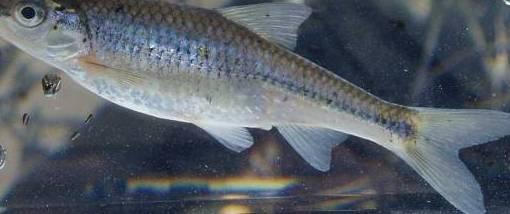
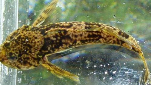
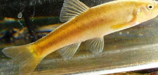
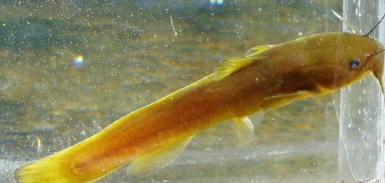
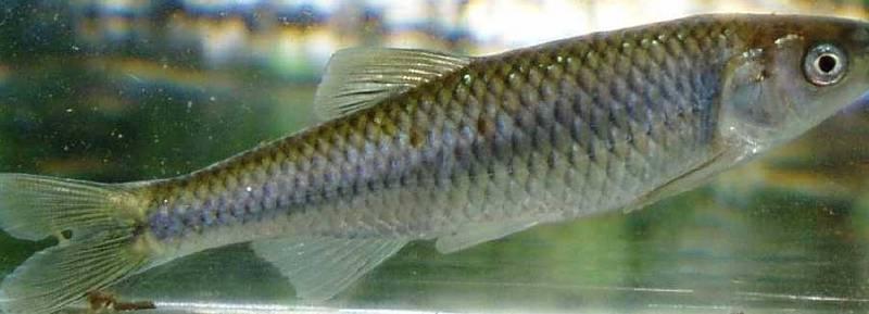
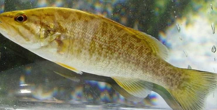
9 Healthy Fish Community Brook Trout Smallmouth Bass Swallowtail Shiner Satinfin Shiner Margined Madtom Cutlips Minnow Slimy Sculpin


10 Impaired Fish Community Mummichog Banded Killifish Green Sunfish White Sucker Common Carp

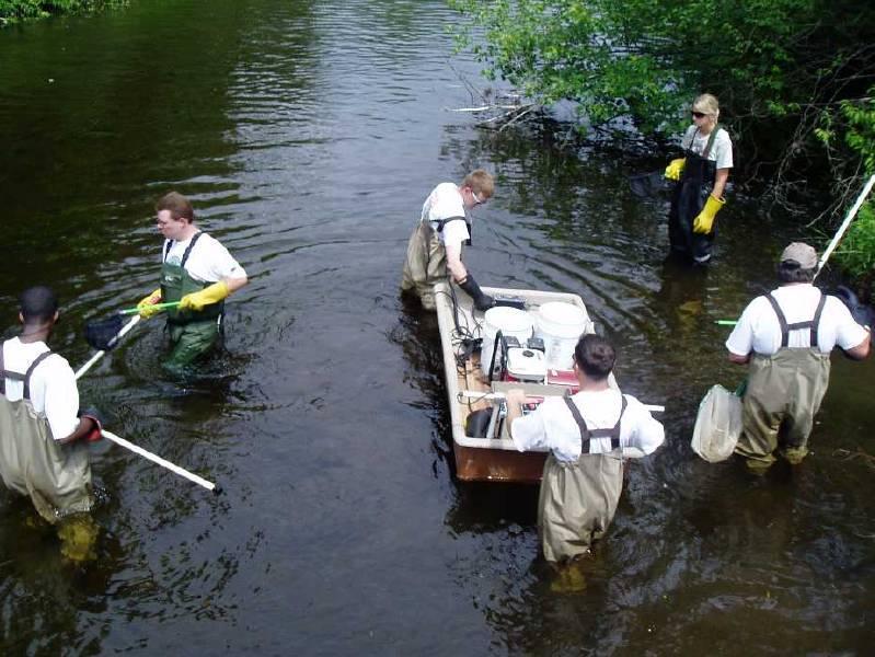
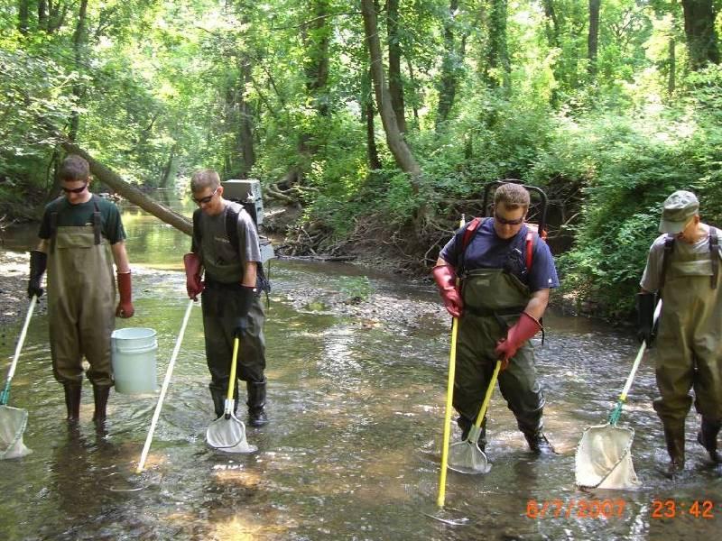
11 Backpack Electrofishing Methods Barge Electrofishing

12 Northern IBI Program Implemented in Fixed Site Network 20 Sites per Year, 5 Year Rotation Index Period June through Mid-October Round 2 Sampling Initiated in 2005
 Final metric revisions greatly increased sensitivity to anthropogenic stressors 50 Round 1 Ratings (Original Metric Scoring) 50 Round 2 Scoring (Revised Metric Scoring) 40 40 Percent 30")
13 Metric Recalibration Round 1 sampling completed in 2004 Metrics recalibrated in 2005 by BFBM using Round 1 data Analysis and modifications reviewed by Fish IBI Workgroup (USEPA, USGS, NJDEP-BFF, NJDEP-BWQS&A) Final metric revisions greatly increased sensitivity to anthropogenic stressors 50 Round 1 Ratings (Original Metric Scoring) 50 Round 2 Scoring (Revised Metric Scoring) Percent Percent Excellent Good Fair Poor 0 Excellent Good Fair Poor


14 Integrated Report 2006 Integrated Water Quality Monitoring and Assessment Report Fish IBI data is used, in concert with available benthic macroinvertebrate data, to help the Department measure aquatic life designated use attainment, as elaborated in the 2006 New Jersey Integrated Water Quality Monitoring and Assessment Report


15 Integrated Report 2006 Integrated Water Quality Monitoring and Assessment Methods document WQMAMethodology.pdf Sites with an FIBI rating of "poor" are considered to be impacted significantly enough that, for purposes of the Department's Water Quality Monitoring and Integrated Assessment Report ( 40 CFR and N.J.A.C. 7:15-6f), they will be categorized as "impaired"


16 Waters Needing Special Attention C1 Anti-degradation Category 1 waters: antidegradation designation - no measurable or predictable water quality change One basis - Exceptional Ecological Significance Monitoring data used - macroinvertebrates, fish IBI, aquatic-dependent T&E species, habitat, physical / chemical, & impervious cover

 Numerous sites on Drakes Brook were")
17 Fish IBI enables quick assessment No laboratory analysis Useful tool for pinpointing stressed areas Other Studies Stressor Identification Provides supplemental information In 2006, 2 sites were sampled (Beaver Brook and Drakes Brook) Numerous sites on Drakes Brook were evaluated

")


18 Case Studies Whippany River FIBI009 FW2-NTC2 Sampled in 2000 & 2005 FIBI Score Poor (26) Habitat Score Sub-optimal Numerous habitat impairments No riparian buffer Numerous outfalls Urbanization (48%) 14% impervious cover Run-off from roads & parking lots High conductivity Numerous abnormalities No insectivorous cyprinids

 Habitat Score")


")


19 Green Brook FIBI097a FW2-NTC2 Sampled in 2005 FIBI Score Poor (22) Habitat Score Marginal Case Studies No riparian buffer Severe bank erosion Heavy siltation Urbanization (65%) 22% impervious cover Run-off from township park High conductivity/low D.O. Low benthic insectivore abundance


20 Case Studies Ireland Brook FIBI051 FW2-NTC2 Sampled in 2003 & 2007 R2 FIBI Score Poor (26) R2 Habitat Score Optimal No obvious habitat or water quality impairments Good riparian buffer/bank vegetation Headwaters mainly urbanized (55%) 19% impervious cover Severe storm water run-off in headwaters

")


21 Case Studies Spruce Run FIBI036 FW2-TPC1 Sampled in 2001 & 2006 R2 FIBI Score Fair (34) R2 Habitat Score Sub-optimal Bridge construction just upstream Impairments to benthic community Insectivorous cyprinids decreased from 66% in 2001 to 16% in 2006 Flash flooding <4% impervious cover Limited riparian buffer Newly formed sediment bars


22 Southern IBI Lower Delaware River Drainage Developed by NJ Fish & Wildlife Piloted by BFBM in 2007 Index Period June through Mid-October
23


24 Any Questions?
Biomonitoring in New Jersey: Status, Gaps, and Refinements
 Biomonitoring in New Jersey: Status, Gaps, and Refinements Dean Bryson New Jersey Department of Environmental Protection Water Monitoring and Standards Bureau of Freshwater and Biological Monitoring January
Municipal Stormwater Management Planning
 Municipal Stormwater Management Planning Christopher C. Obropta, Ph.D., P.E. Water Resources Extension Specialist with Rutgers Cooperative Extension Assistant Professor with Department of Environmental
Finding Data Gaps: Compiling and Interpreting Existing Data
 Finding Data Gaps: Compiling and Interpreting Existing Data Christopher C. Obropta Extension Specialist in Water Resources 732-932 932-4917 www.water.rutgers.edu Defining Scope of Planning Effort Ensures
Biological Uplift in Stream Restoration Projects. September 20, Presentation by: Wetlands and Waterways Program
 Biological Uplift in Stream Restoration Projects September 20, 2017 Presentation by: Wetlands and Waterways Program Integrated Water Planning Program Maryland Department of the Environment Wetlands & Waterways
Appendix D3. Aquatic Resources. Tennessee Valley Authority Reservoir Operations Study Final Programmatic EIS
 Tennessee Valley Authority Reservoir Operations Study Final Programmatic EIS This page intentionally left blank. D3.1 Fish Index of Biotic Integrity (Used in Tailwaters)... D3-1 D3.2 Benthic Index of Biotic
APPENDIX H Guidance for Preparing/Reviewing CEQA Initial Studies and Environmental Impact Reports
 APPENDIX H H.1 Guidance for Preparing and Reviewing CEQA Initial Studies Step 1: Consider the Project Characteristics as Provided by the Project Applicant Review the project application and draft plan
DRAFT Introduction:
 Introduction: Bay Area Macroinvertebrate Bioassessment Information Network San Francisco Bay Area Creeks Benthic Index of Biotic Integrity (IBI) Draft IBI Workplan v.4 The following describes a series
Maumee Area of Concern Water Quality Database Development
 Maumee Area of Concern Water Quality Database Development Project Overview Background In 1987 the Maumee Area of Concern (AOC) in northwest Ohio was designated as an Area of Concern based on the identification
Carp Creek 2013 Summary Report
 Monitoring Activity in the Carp River Watershed In 2012, Mississippi Valley Conservation Authority (MVCA) worked with Friends of the Carp River (FCR) on a preliminary assessment of the Carp River. This
Linda Cooper, Eno River State Park, Durham, NC
 Linda Cooper, Eno River State Park, Durham, NC 2 Rivers and Streams All 50 states, 2 interstate river commissions, American Samoa, Guam, Puerto Rico, the District of Columbia (collectively referred to
Susquehanna River Smallmouth Bass Disease Investigation
 Susquehanna River Smallmouth Bass Disease Investigation May 9, 2013 Dial-in number for Audio: 1-877-668-4493 Event Number: 647 572 664 WebEx Technical Support: 866-229-3239 Note: You will not hear any
BIG ROCHE A CRI LAKE CHARACTERISTICS
 BIG ROCHE A CRI LAKE CHARACTERISTICS Lake Description Big Roche Cri Lake is located in north central Adams County and has a surface area of 205 acres, a shoreline length of 6.1 mile, a volume of 6,993
Raritan River Basin. How to protect quality & quantity of water resources? Land Protection and Management to Protect Water Resources
 Land Protection and Management to Protect Water Resources New Jersey Water Supply Authority: Kathy Hale, Principal Watershed Protection Specialist (908) 685-0315 x228 khale@raritanbasin.org Jen Zhang,
Climate Change: Impacts, Monitoring, and Solutions
 Climate Change: Impacts, Monitoring, and Solutions 1 Responding to Climate Change 1. Projections/Impacts 2. Adaptation and Resiliency 3. Monitoring 4. What about emissions? 2 Native trout and salmon are
Amanda Deal & Len Lichvar Somerset Conservation District
 Stonycreek River Watershed Reassessment Amanda Deal & Len Lichvar Somerset Conservation District August 2008 Watershed Characteristics ti 298,920 acres 538 perennial stream miles 519 mi natural stream/river
MURPHY DRAIN CATCHMENT
 The RVCA produces individual reports for 16 catchments in the Lower Rideau subwatershed. Using data collected and analysed by the RVCA through its watershed monitoring and land cover classification programs,
2016 New Jersey Integrated Water Quality Assessment Methods FINAL
 Division of Water Monitoring and Standards Bureau of Environmental Analysis, Restoration and Standards 2016 New Jersey Integrated Water Quality Assessment Methods FINAL This document was prepared pursuant
CITY OF GRIFFIN STREAM BANK RESTORATION PROGRAM
 CITY OF GRIFFIN STREAM BANK RESTORATION PROGRAM Lee Phillips 1, J. Erik Alford2 and M. Brad McLeod 3 AUTHORS: 'Project Engineer, Integrated Science & Engineering, 118 North Expressway, Griffin, GA 30223;
Index of Watershed Indicators: An Overview
 Index of Watershed Indicators: An Overview U.S. Environmental Protection Agency Office of Wetlands, Oceans, and Watersheds Table of Contents Introduction...1 Questions and Answers...3 Flow Charts for the
BUREAU OF CLEAN WATER OUTSIDE AGENCY DATA AND QUALITY ASSURANCE REQUIREMENTS
 BUREAU OF CLEAN WATER OUTSIDE AGENCY DATA AND QUALITY ASSURANCE REQUIREMENTS JULY 2013 WATER QUALITY ASSESSMENT 305(b) Report/ 303(d) List EXISTING AND READILY AVAILABLE DATA MINIMAL DATA REQUIREMENTS
Riffle Beetles to Riparian Buffers
 We care about WateR. it S What We do. Riffle Beetles to Riparian Buffers Exploring Methods of Assessing Surface Water Quality Grade level: 7-12 objective: Students will evaluate the quality of two water
Technical Memorandum. Ipswich and Shawsheen River Watersheds 2005 Fish Population Monitoring and Assessment
 Technical Memorandum Ipswich and Shawsheen River Watersheds 2005 Fish Population Monitoring and Assessment Robert J. Maietta Massachusetts Department of Environmental Protection Division of Watershed Management
KRISTOPHER J. KRZYSTON, CEI, CEM
 PERMITTING IN NEW JERSEY KRISTOPHER J. KRZYSTON, CEI, CEM Kristopher J. Krzyston Rutgers graduate 1994 B.S. Environmental Planning Certificate in G.I.S. Assistant Division Manager Environmental Science
Portage Lake Hubbard County
 Prepared in cooperation with the Minnesota Department of Natural Resources Minnesota Lake ID: 9- Area: acres Watershed Area: 6,7 acres Ecoregion: Northern Lakes and Forests (NLF) Portage Lake Hubbard County
Senator Bob Smith 216 Stelton Rd, Suite E-5 Piscataway, NJ April 7, Dear Senator Smith,
 Senator Bob Smith 216 Stelton Rd, Suite E-5 Piscataway, NJ 08854 April 7, 2016 Dear Senator Smith, Per your request, summarized below and attached in detail are the signed organizations top 10 agreed upon
CERP System Status Reports The Evolution from
 CERP System Status Reports The Evolution from 2006-2009 Eliza Hines 22 July 2009 Everglades Restoration Comprehensive Everglades Restoration Plan (CERP) 18,000 sq mile ecosystem Everglades & South Florida
Patrick Center for Environmental Research
 Patrick Center for Environmental Research MISSION STATEMENT The Patrick Center for Environmental Research, established within the Academy of Natural Sciences in 1947, is a multidisciplinary group of scientists
3 Objectives 3 Ob jec tives
 3 Objectives 3 Objectives 3 Objectives 3 Objectives contents Objective number Page 3.1 Ki uta ki tai: mountains to the sea O1-O5 37 3.2 Beneficial use and development O6-O13 38 3.3 Māori relationships
Biological Water Quality Assessments and Criteria in Korea
 Biological Water Quality Assessments and Criteria in Korea Soon-Jin Hwang 1, Jae-Kwan Lee, Jae-Hyun Lee 3, Soon Cho 3, Doo-Hee Won, Kwang-Guk An 5 1 Department of Environmental Science, Konkuk University,
Chapter Three: Discussion and Conclusion. 3.1 Introduction/Overview. 3.2 Countywide Stream Assessment
 3.1 Introduction/Overview The objective of this study was to develop a stream prioritization tool that evaluates stream reaches in terms of the potential water quality improvements that could be achieved
STREAM AND BUFFER AREA PROTECTION/RESTORATION
 STREAM AND BUFFER AREA PROTECTION/RESTORATION AMENDMENT OPTIONS TO STRENGTHEN POLICY IN HEADWATERS AREAS DRAFT SUBSEQUENT TO THE JANUARY 25, 2007 MEETING OF THE PLANNING COMMISSION ENVIRONMENT COMMITTEE
Lesson 2-2: Riparian Zones
 2-14 Lesson 2-2: Riparian Zones Time of Lesson: 1 hour Rationale: The purpose of this lesson is to define what a riparian zone is and link its importance for fish and other animals, and humans, and the
Natural Resources and Climate Resiliency in Germantown
 Natural Resources and Climate Resiliency in Germantown Ingrid Haeckel, Andrew Meyer, and Elizabeth Murphy NYSDEC Hudson River Estuary Program and Cornell University Presentation to the Town of Germantown,
Comfort Lake-Forest Lake Watershed District Six Lakes Total Maximum Daily Load Implementation Plan
 Prepared by: for the Comfort Lake-Forest Lake Watershed District and the Minnesota Pollution Control Agency Comfort Lake-Forest Lake Watershed District Six Lakes Total Maximum Daily Load February 16, 2010
What Are Environmental (Instream) Flows?
 Flows?") 1 What Are Environmental (Instream) Flows? Sustainable water management requires that both human needs and the needs of aquatic and riparian ecosystems be fulfilled. Dams and diversion of water for municipal
1 What Are Environmental (Instream) Flows? Sustainable water management requires that both human needs and the needs of aquatic and riparian ecosystems be fulfilled. Dams and diversion of water for municipal
Riparian Buffers and Stream Restoration
 Riparian Buffers and Stream Restoration Why focus on riparian areas? Link land and water on any given site and link landscapes together in a watershed Riparian corridors protect the circulatory system
WATERSHED. Maitland Valley. Report Card 201
 Maitland Valley WATERSHED Report Card 201 The Maitland Valley Conservation Authority has prepared this report card as a summary on the state of our forests, wetlands, surface water, and ground water resources.
Habitat Grant Projects Clinton River Watershed
 Habitat Grant Projects Clinton River Watershed L Y N N E S E Y M O U R E N V I R O N M E N T A L E N G I N E E R O F F I C E O F T H E M A C O M B C O U N T Y P U B L I C W O R K S C O M M I S S I O N
Chapter 4 Watershed Goals and Objectives
 Chapter 4 Watershed Goals and Objectives Eight (8) long-term watershed goals have been developed by the NEW Watershed Advisory Group (WAG) after consideration of discussions held during monthly watershed
NJDEP Regulations that impact or soon will impact agricultural operations. April 1, 2007 Horses 2007
 NJDEP Regulations that impact or soon will impact agricultural operations. April 1, 2007 Horses 2007 Peter L. Kallin, Ph.D., P.W.S. Phone: 732-499-3600 Ext. 237 E-mail: pkallin@aesop.rutgers.edu www.water.rutgers.edu
A Summary Guide to the. Rifle River WATERSHED MANAGEMENT PLAN. Know Your Watershed Protect Its Resources
 A Summary Guide to the Rifle River WATERSHED MANAGEMENT PLAN Know Your Watershed Protect Its Resources Table of Contents The Watershed... 3 The Management Plan... 4 Designated and Desired Uses... 5 Sources
Hydrologic and Ecologic Impacts from the CERP Indian River Lagoon South Project
 Hydrologic and Ecologic Impacts from the CERP Indian River Lagoon South Project Dr. Gretchen Ehlinger Senior Biologist US Army Corps of Engineers Jacksonville District November 15, 2016 AWRA Conference
AP Environmental Science
 AP Environmental Science Types of aquatic life zones MARINE Estuaries coral reefs mangrove swamps neritic zone pelagic zone FRESHWATER lakes and ponds streams and rivers wetlands Distribution of aquatic
9. Evaluation Mechanisms
 9. Evaluation Mechanisms Not everything that can be counted counts, and not everything that counts can be counted. - Albert Einstein Introduction Watershed planning is meant to be an iterative process
AP Environmental Science
 2017 AP Environmental Science Sample Student Responses and Scoring Commentary Inside: RR Free Response Question 4 RR Scoring Guideline RR Student Samples RR Scoring Commentary 2017 The College Board. College
Ecological Indicators of Water Resource Pressure. Willie Duncan SEPA Jan 2013
 Ecological Indicators of Water Resource Pressure Willie Duncan SEPA Jan 2013 Outline Methods River Water Resources River Morphology Lakes Water Resources/Morphology Format Improvements over previous methods.
Ohio Department of Natural Resources Division of Watercraft. Scenic Rivers Program
 Ohio Department of Natural Resources Division of Watercraft Scenic Rivers Program Ohio s Scenic Rivers First program in the nation, started in 1968 14 designated streams totaling 800 miles Scenic River
Fort Clatsop Restoration Project Summary Report
 Fort Clatsop Restoration Project Summary Report Report written by the Columbia River Estuary Study Taskforce October, 2007 Figure 1: Site Map Fort Clatsop Estuarine Restoration Project Columbia River Estuary
VILLAGE OF BELLAIRE WATER QUALITY ACTION PLAN
 VILLAGE OF BELLAIRE WATER QUALITY ACTION PLAN Elk-River-Chain-of-Lakes Gaps Analysis Project The Watershed Center Grand Traverse Bay Tip of the Mitt Watershed Council Michigan Department of Natural Resources
Watts Creek 2014 Summary Report
 Monitoring Activity in the City of Ottawa In 2012, Mississippi Valley Conservation Authority (MVCA) and the Friends of the Carp River (FCR) collaborated to undertake a broad scale assessment of potential
FACTSHEET INTRODUCTION. help rebalance the water cycle, mitigate the effects of climate change and improve human health and livelihoods.
 1 FACTSHEET INTRODUCTION World Water Day, on 22 March every year, is about focusing attention on the importance of water. This year s theme, Nature for Water, explores nature-based solutions (NBS) to the
RIDEAU RIVER - RIDEAU FALLS CATCHMENT
 Catchment Facts An intensively, urbanized reach within the City of Ottawa with some large expanses of green space found along the river corridor; the only reach in the Lower Rideau that remains in its
The status of aquatic ecosystems in the Basin
 AQUATIC SPECIES AND HABITATS The status of aquatic ecosystems in the Basin is influenced by both natural and human processes. The geologic and geomorphic processes described earlier formed and continue
APPENDIX F. Receiving Water Conditions, Potential Impacts of MS4 Discharges, and Priority Water Quality Conditions in the San Dieguito River WMA
 APPENDIX F Receiving Water Conditions, Impacts of MS4 Discharges, and Priority Water Quality Conditions in the San Dieguito River WMA Intentionally Left Blank Appendix F Receiving Water Conditions, Impacts
Lake Pepin Watershed TMDL: Looking Ahead. August 2008 Sector Meetings. Lake Pepin Photo by Guy Schmickle
 Lake Pepin Watershed TMDL: Looking Ahead August 2008 Sector Meetings Lake Pepin Photo by Guy Schmickle Three Questions What are the critical issues to face moving forward? How can we as a sector address
Water Quality Workshop Delaware Bay Region Pilot Study Summary. March 11, 2008
 Water Quality Workshop Delaware Bay Region Pilot Study Summary March 11, 2008 Structure of the Design Nine resource compartments Fixed station and probabilistic designs Core variables and sampling frequencies
EXISTING AND READILY AVAILABLE DATA
 EXISTING AND READILY AVAILABLE DATA The Bureau of Clean Water s Water Quality Division is seeking data for consideration in the 2018 303(d) assessment process. Data will be accepted until September 30
North Dakota s Nutrient Reduction Strategy. Presented to the 2016 ND Water Quality Monitoring Conference March 4, 2016
 North Dakota s Nutrient Reduction Strategy Presented to the 2016 ND Water Quality Monitoring Conference March 4, 2016 Nutrients Nutrients, in appropriate amounts, are essential to the growth and health
FREQUENTLY ASKED QUESTIONS: URBAN STREAM RESTORATION BMP. David Wood Chesapeake Stormwater Network. Lisa Fraley-McNeal Center for Watershed Protection
 FREQUENTLY ASKED QUESTIONS: David Wood Chesapeake Stormwater Network URBAN STREAM RESTORATION BMP Lisa Fraley-McNeal Center for Watershed Protection Bill Stack Center for Watershed Protection FREQUENTLY
Recent Developments in Water Withdrawal Management
 Recent Developments in Water Withdrawal Management Frank Ruswick David A. Hamilton Michigan Department of Environmental Quality Overview What Water Withdrawals are regulated? Water Withdrawal Assessment
The development of the Big Pond Dip invertebrate survey method
 The development of the Big Pond Dip invertebrate survey method Pond Conservation (March 2010) www.pondconservation.org.uk The development of the Big Pond Dip invertebrate survey method 1. Introduction
Biodiversity Debate. To evaluate the biological, aesthetic, ethical, social and economic arguments with regard to maintaining biodiversity.
 Purpose: Summary: To evaluate the biological, aesthetic, ethical, social and economic arguments with regard to maintaining biodiversity. In this exercise, students will hold a debate about the construction
Department of the Army Permit Application
 Department of the Army Permit Application DA File Number U.S. Army Corps of Engineers Honolulu District Date Received by CEPOH-RO Send Completed Application to: Honolulu District, U.S. Army Corps of Engineers
VIDEO: Riparian Forest Buffers: The Link Between Land & Water
 VIDEO: Riparian Forest Buffers: The Link Between Land & Water Introduction to Riparian Buffers Adapted from: Riparian Forest Buffers: The Link Between Land & Water. Maryland Cooperative Extension. Wye
Lisa Hauck Stream Restoration May
 The Effects of Stream Restoration on Habitat Quality Lisa Hauck Abstract Many stream restoration projects do not include a requirement for long-term monitoring after the project has been completed, resulting
ECOSYSTEMS, WATERSHEDS AND POLLUTION CONTROL REVIEW
 ECOSYSTEMS, WATERSHEDS AND POLLUTION CONTROL REVIEW ECOSYSTEMS: (6 th grade content) How biotic and abiotic factors make an ecosystem: https://www.youtube.com/watch?v=mdlwptkg-vi 1. A/An ecosystem is a
Overview of the Clean Water Act and Water Quality Standards
 Overview of the Clean Water Act and Water Quality Standards TLEF, August 17, 2015 Heather Goss, USEPA, Water Quality Standards program (standing in for Tom Gardner) 1 Today s goal Provide a basic introduction
POLICY FOR NATURAL RESOURCE MANAGEMENT AREAS
 POLICY FOR NATURAL RESOURCE MANAGEMENT AREAS I. POLICY STATEMENT Auburn University's (the University's) "Policy for Natural Resource Management Areas" implements the Campus Master Plan Land Use Element
SUSTAINABLE WATER BRIEFING. MWRA Advisory Board
 SUSTAINABLE WATER MANAGEMENT INITIATIVE BRIEFING MWRA Advisory Board November 15, 2012 KEY ACHIEVEMENTS Science based taxonomy of 1400 Subbasins Streamflow criteria based on science Resolution of Sf Safe
Nutrients and Water Quality in the East Souris River Watershed
 Nutrients and Water Quality in the East Souris River Watershed Phosphorus and nitrogen occur naturally and are important plant nutrient sources in water bodies. However, several human factors have created
Factsheet: Town of Deep River Water Quality and Stormwater Summary
 79 Elm Street Hartford, CT 06106-5127 www.ct.gov/deep Affirmative Action/Equal Opportunity Employer Factsheet: Town of Deep River Water Quality and Stormwater Summary This document was created for each
Reporting Period: 01/01/2010 to 12/31/2010. Understanding the Level 2 Stream Monitoring Data Report
 Eau Claire River at Outlet Bay Rd, 10029003 Upper Eau Claire Lake Latitude: 46.302803, Longitude: -91.50336 Susan Peterson, Friends of the Saint Croix Headwaters John Kudlas, Friends of the St.Croix Headwaters
Hydrology and Water Quality. Water. Water 9/13/2016. Molecular Water a great solvent. Molecular Water
 Hydrology and Water Quality Water Molecular Water Exists as an equilibrium But equilibrium altered by what is dissolved in it Water Molecular Water a great solvent In reality, water in the environment
TORCH LAKE TOWNSHIP WATER QUALITY ACTION PLAN
 TORCH LAKE TOWNSHIP WATER QUALITY ACTION PLAN Elk-River-Chain-of-Lakes Gaps Analysis Project The Watershed Center Grand Traverse Bay Tip of the Mitt Watershed Council Michigan Department of Natural Resources
719 Griswold, Suite 820 Detroit, MI DANVERS POND DAM REMOVAL AND STREAM RESTORATION PROJECT
 Great Lakes Restoration Initiative Grant Final Report US EPA Grant GL 00E006 43 October, 2013 Valley Woods Wetland Southfield Lola Valley Grow Zone Wayne County Parks Venoy Park Grow Zone Wayne County
APPENDIX H MONITORING & ADAPTIVE MANAGEMENT PLAN
 BUBBLY CREEK, SOUTH BRANCH OF THE CHICAGO RIVER, ILLINOIS FEASIBILITY STUDY APPENDIX H MONITORING & ADAPTIVE MANAGEMENT PLAN DRAFT REPORT - NOT FOR DISTRIBUTION APRIL 2015 BUBBLY CREEK, SOUTH BRANCH OF
2016 Lake Worth Lagoon CAP 1135 Benthic Macroinvertebrate Study. Preliminary Results
 2016 Lake Worth Lagoon CAP 1135 Benthic Macroinvertebrate Study Preliminary Results Study Objectives Section 1135 of the Water Resources Development Act of 1986 - U.S. Army Corps of Engineers may plan,
The total population of the township is 9,942 (2015 Five-Year American Community Survey [ACS]). The median household income is over $109,000.
![The total population of the township is 9,942 (2015 Five-Year American Community Survey [ACS]). The median household income is over $109,000.](/thumbs/72/67990406.jpg "The total population of the township is 9,942 (2015 Five-Year American Community Survey [ACS]). The median household income is over $109,000.") East Bradford Township, Pennsylvania Motivated by watershed impairment caused by suburban development over the past 30 years, a township with a full slate of water quality improvement programs looks outside
East Bradford Township, Pennsylvania Motivated by watershed impairment caused by suburban development over the past 30 years, a township with a full slate of water quality improvement programs looks outside
Rewards, Challenges, Approaches and Solutions for Developing the Soos Creek Bioassessment TMDL
 Western Washington University Western CEDAR Salish Sea Ecosystem Conference 2014 Salish Sea Ecosystem Conference (Seattle) May 1st, 10:30 AM - 12:00 PM Rewards, Challenges, Approaches and Solutions for
Elements of the Storm Water Management Plan. Storm Water Pollution Prevention Plan (SWPPP)
") Elements of the Storm Water Management Plan Storm Water Pollution Prevention Plan (SWPPP) Small Construction Site Storm Water Management Rodney Hendrick Water Quality Specialist LSU Ag Center Plan Requirements
Elements of the Storm Water Management Plan Storm Water Pollution Prevention Plan (SWPPP) Small Construction Site Storm Water Management Rodney Hendrick Water Quality Specialist LSU Ag Center Plan Requirements
SKIBO PROJECT SCOPING REPORT Laurentian Ranger District, Superior National Forest
 SKIBO PROJECT SCOPING REPORT Laurentian Ranger District, Superior National Forest I. Introduction The Laurentian Ranger District of the Superior National Forest is proposing management activities within
SPARTA TOWNSHIP MUNICIPAL STORMWATER MANAGEMENT PLAN. April 2005
 SPARTA TOWNSHIP MUNICIPAL STORMWATER MANAGEMENT PLAN Sparta Township, Sussex County, New Jersey April 2005 David Troast, P.P., A.I.C.P., C.L.A Charles P. Ryan, P.E., Sparta Township Planner Sparta Township
Assessing Natural Resource Impacts from the Enbridge Pipeline Spill into the Kalamazoo River
 Assessing Natural Resource Impacts from the Enbridge Pipeline Spill into the Kalamazoo River Stephanie Millsap, Lisa Williams, and Joseph Haas - U.S. Fish & Wildlife Service Sharon Hanshue and Jay Wesley
Lake Tahoe Nearshore Evaluation and Monitoring Framework Report
 Lake Tahoe Nearshore Evaluation and Monitoring Framework Report TRPA Governing Board October 23, 2013 By Alan Heyvaert, Ph.D Acting Senior Director Center for Watersheds and Environmental Sustainability,
Wyoming Stream Quantification Tool User Manual (Beta Version)
") Wyoming Stream Quantification Tool User Manual (Beta Version) Wyoming Stream Quantification Tool User Manual Beta Version August 2017 Lead Agency: U.S. Army Corps of Engineers, Omaha District, Wyoming
Wyoming Stream Quantification Tool User Manual (Beta Version) Wyoming Stream Quantification Tool User Manual Beta Version August 2017 Lead Agency: U.S. Army Corps of Engineers, Omaha District, Wyoming
Modeling Fate and Effects of Multiple Stressors on a Use- Impaired River
 Society for Environmental Toxicology & Chemistry Salt Lake City, Utah, November 18, 2002 Modeling Fate and Effects of Multiple Stressors on a Use- Impaired River Abstract Modeling the Effects of Multiple
Polluted Runoff and Land Conservation: What s the Connection?
 Polluted Runoff and Land Conservation: What s the Connection? Caroly Shumway, Ph.D. Executive Director, Merrimack River Watershed Council In partnership with NMCOG Overview Purpose Of This Talk Is To Convey
Council of Governments
 Metropolitan Washington Council of Governments Anne Arundel County Draft Phase II Watershed Implementation Plan January 18, 2011 Chesapeake Bay TMDL Pollutants of Concern Nitrogen Phosphorus Sediment 2
Macroinvertebrates as bioindicators
 Macroinvertebrates as bioindicators Now that you have collected a standardized sample of the stream benthic community, we will now evaluate that sample to calculate an Index of Biotic Integrity (IBI).
Using Airborne Imagery, GIS & Remote Sensing for Ecological Monitoring and Mapping
 Using Airborne Imagery, GIS & Remote Sensing for Ecological Monitoring and Mapping Multi-spectral Aerial Photography Geo-referenced Oblique Aerial Photography Tools and Mapping Products AES Imaging Plane
The Grand River. Overview of Water Quality and Ecological Health. Daniel M. O Keefe, Ph.D. Michigan Sea Grant MSU Extension
 The Grand River Overview of Water Quality and Ecological Health Daniel M. O Keefe, Ph.D. Michigan Sea Grant MSU Extension How does surface water quality in Ottawa County compare to other areas of the state?
Highlands Environmental Resource Inventory for the [insert municipality name]tewksbury Township
![Highlands Environmental Resource Inventory for the [insert municipality name]tewksbury Township](/thumbs/72/66861609.jpg "Highlands Environmental Resource Inventory for the [insert municipality name]tewksbury Township") Highlands Environmental Resource Inventory for the [insert municipality name]tewksbury Township 2009 This Module 4 Highlands ERI for Tewksbury Township was completed by Kratzer Environmental Services using
Highlands Environmental Resource Inventory for the [insert municipality name]tewksbury Township 2009 This Module 4 Highlands ERI for Tewksbury Township was completed by Kratzer Environmental Services using
General Plan Update Workshop 6 Agriculture, Conservation, & Open Space February 23, 2005
 General Plan Update Workshop 6 Agriculture, Conservation, & Open Space February 23, 2005 Municipal Services Agency Planning and Community Development Department Workshop Outline GPU Update Background &
Task 1: Framework for a Reexamination. Falls Nutrient Strategy
 Task 1: Framework for a Reexamination of Stage II of the Falls Nutrient Strategy Prepared for: Upper Neuse River Basin Association Prepared by: Cardno ENTRIX 5400 Glenwood Ave, Suite G03, Raleigh, NC,
Restoration and Protection of the Water Resources of the Greenwood Lake Watershed in New Jersey
 Restoration and Protection of the Water Resources of the Greenwood Lake Watershed in New Jersey Greenwood Lake Commission Bi-state commission that was formed in 2001 for the express purpose of improving
Living Shorelines & Coastal Resiliency: A Consultants Perspective. Presented by: Bethany Bearmore, P.E. Louis Berger
 Living Shorelines & Coastal Resiliency: A Consultants Perspective Presented by: Bethany Bearmore, P.E. Louis Berger Living Shorelines & Coastal Resiliency A Consultants Perspective 1. Why 2. Process 3.
Healthy Watersheds Assessment. Potomac Watersheds in West Virginia
 Healthy Watersheds Assessment Potomac Watersheds in West Virginia Watershed Assessment - Goals Develop metrics to measure current condition/function & threats Rank watersheds for restoration & protection