NATURAL RESOURCE PLANNING BOUNDARIES FOR JANUARY 2010 FLORIDA FOREVER PROPOSALS
|
|
|
- Norman Porter
- 5 years ago
- Views:
Transcription


1 NATURAL RESOURCE PLANNING BOUNDARIES FOR JANUARY 2010 FLORIDA FOREVER PROPOSALS Prepared by Florida Natural Areas Inventory 1018 Thomasville Road Suite 200-C Tallahassee, FL Gary R. Knight Program Director
2 As part of an agreement with the Florida Department of Environmental Protection (DEP), the Florida Natural Areas Inventory (FNAI) provides data and expertise to assist with the multi-step process of evaluating lands proposed for acquisition through the Florida Forever Program. FNAI recently provided Preliminary Evaluations of the proposals received by DEP for the cycle starting in January Here we provide an analysis of the Natural Resource Planning Boundaries for the proposals voted for additional consideration by the Acquisition and Restoration Council (ARC). The purpose of the Natural Resource Planning Boundary analysis is to review and, if necessary, adjust the proposed project boundaries to incorporate lands needed to protect the identified resources or to exclude lands that are not necessary to doing so. The proposals were considered with respect to the Florida Forever Goals and Measures identified by DEP and listed with each of the following evaluations. The proposed boundaries, and potential additions and deletions, were examined with respect to the following: rare species natural areas evident on aerial photography (DOQQs) hydrology and natural drainage systems nearby managed conservation lands or other land protection projects FL Fish and Wildlife Conservation Commission Strategic Habitat Conservation Areas land management (e.g., controlled burn boundaries, fence lines, roads) nearby natural features of interest exclusion of capital improvement (e.g., buildings) unless located in areas critical to the integrity of the project Recommended additions or deletions are accompanied by a brief statement of justification. Ownership of the recommended additions and deletions was not considered during this phase of the evaluation. Because of rapid changes occurring throughout the state, on-ground assessment is needed to confirm the resources within the proposed boundaries and the current condition of the landscape. The boundaries illustrated on the enclosed maps are approximate.
3 Florida National Scenic Trail - Phase II (Santa Rosa, Okaloosa, and Washington Counties) Resource Planning Boundary The Florida National Scenic Trail Phase II (FNST-II) consists of three sites comprising seven properties and covering acres in Santa Rosa, Okaloosa, and Washington counties. All properties are proposed for fee simple acquisition. The proposed Florida Forever Goals and Measures for FNST-II are listed at the end of this evaluation. Natural resource values for FNST- II are highlighted in the Preliminary Evaluation of January 2010 Florida Forever Proposals. FNAI staff assessed the potential for additions and deletions to the proposal boundary based on interpretation of 2007 (Santa Rosa and Okaloosa counties) and 2009 (Washington County) onefoot resolution digital photography. No additions or deletions are proposed at this time although suggestions for possible additions that may be considered in the future are given below. Santa Rosa County site Acquisition of this site would leave an approximately 40-acre, square-shaped, inholding between the eastern boundary of the site and the Yellow River Water Management Area (WMA). The 40 acres is comprised of about half sandhill natural community and half wetland forested communities; it is unclear from aerial photographs whether a building or residence (shown on old topographic map) is present. Nichols Creek runs northeast/southwest through the center of the site and continues both north and south through the proposed site boundaries. Another roughly 40-acre block occurs on the south boundary of the site and would provide a connection with the Yellow River WMA on the south if acquired. Acquisition would also provide protection for the last stretch of Nichols Creek before if flows through the WMA to the Yellow River to the south. Natural communities appear to be similar to the above-mentioned site. Okaloosa County site The dramatic relief of this site, considered a prime feature by the applicant, continues west of the southwestern boundary of the site. This area includes approximately 120 acres of intact sandhill that slopes down through upland hardwood forest to the wetter communities on the Yellow River WMA. The FNST is currently routed through the WMA in this area; acquisition to the north may provide a drier path for the trail. Washington County site The FNST s preferred route runs north-south through the site and continues due south through a single narrow ownership, then curves its way through a second larger ownership to Pine Log State Forest, which borders this ownership on the east. An existing trail runs through Pine Log State Forest. Both parcels appear to consist of relatively dense but intact sandhill. The larger parcel exhibits a sharp drop in elevation on its western side as it approaches the Choctawhatchee River. Acquisition of the larger parcel would provide a marginal connection (intervening secondary road and one or more houses) between Pine Log State Forest and Choctawhatchee River Water Management Area to the west.
4 FLORIDA NATIONAL SCENIC TRAIL PHASE II Application Addendum Section , (4), (9) and (10) Florida Statues FLORIDA FOREVER GOALS & PERFORMANCE MEASURES SECTION (4) GOAL C: PROTECT, RESTORE, AND MAINTAIN THE QUALITY AND NATURAL FUNCTIONS OF LAND, WATER, AND WETLAND SYSTEMS OF THE STATE. Measure C4: The number of acres acquired that protect natural floodplain functions. Measure C5: The number of acres acquired that protect surface waters of the state; GOAL E: INCREASE NATURAL RESOURCE-BASED PUBLIC RECREATIONAL AND EDUCATIONAL OPPORTUNITIES Measure E1: The number of acres acquired that are available for natural resource-based public recreation or education. Measure E2: The miles of trails that are available for public recreation, giving priority to those that provide significant connections including those that will assist in completing the Florida National Scenic Trail. GOAL F: PRESERVE SIGNIFICANT ARCHAEOLOGICAL OR HISTORIC SITES Measure F1: The increase in the number of and percentage of historic and archaeological properties listed in the Florida Master Site File or National Register of Historic Places which are protected or preserved for public use. CRITERIA Section (9) and (10), Florida Statutes (9)(a) The project meets multiple goals described in subsection (4). (c) The project enhances or facilitates management of properties already under public ownership. (d) The project has significant archaeological or historic value.

5

6

7
8 Peace River Refuge (DeSoto County) Resource Planning Boundary The Peace River Refuge Florida Forever proposal is 2,163 acres in central DeSoto County proposed for less-than-fee acquisition. The proposal lies just southwest of the city of Arcadia and flanks both sides of the Peace River for almost five river miles. However, three large inholdings border the east riverbank, totaling almost one mile of east bank frontage. Many smaller lots totaling about 162 acres form inholdings on the western half of the proposal. The applicant notes that some parcels may still be in the process of acquisition by the proposal s landowner. If purchased, Peace River Refuge would contribute to a potential natural corridor along the Peace River. The property supports large areas of hydric hammock plus pine flatwoods, mesic hammock, basin and depression marshes, cypress swamps, and open sandy bars along the river. Details on the natural resource and rare species values for this proposal are highlighted in the Preliminary Evaluation of January 2010 Florida Forever Proposals. FNAI staff assessed the potential for additions and deletions to the proposal boundary based on interpretation of 2006 DOQQ aerial photographs. Seven additions are proposed to increase floodplain protection and to create a simplified boundary. A1 This addition would protect an additional 786 acres stretching from the northern edge of the current proposal boundary north to SR-70 in Arcadia, creating a floodplain corridor between Morgan Park (a county park in Arcadia) and the proposal. This land is mostly in natural or seminatural condition, with the exception of an improved pasture in the southeast corner of the addition. The northwest corner contains an occurrence of sleeping beauty waterlily (Nymphaea jamesoniana; G5, S2S3, N, LE)). A2 This is a small (18 acre) piece of natural land adjacent to the western boundary of the property. A potential scrub community (based on aerial photography) appears to occupy about a third of the addition. A3, A4, A5, A6 All parcels internal to the original proposal boundary are proposed for addition, with the single exception of a developed lot near the western border. On the western side of the river, the many one-acre lots were all grouped together as A3. Fronting the eastern side of the river are three additions comprised of larger (two- to six-acre) parcels. These additions are: A4 (24 acres), A5 (22 acres), and A6 (6 acres). According to the proposal s representative at the February ARC meeting, the proposal s landowner is actively acquiring some of these internal lots. These additions are proposed to minimize inholdings that could complicate management. A7 This is a 2,839-acre addition that would extend protection south along the river to the boundary of another Florida Forever proposal currently under consideration, Peaceful Horse Ranch. This addition furthers the proposal s stated goal of protecting surface waters and natural floodplain function. The land is mostly in natural or semi-natural condition with hydric hammock and mesic flatwoods in addition to the river and its associated floodplain features. A
9 bald eagle (Haliaeetus leucocephalus; G5, S3, N, N) nest is documented within the addition boundary, and much of the area falls under FNAI Priority Habitat for wood storks (Mycteria americana; G4, S2, LE, LE*), Florida sandhill cranes (Grus canadensis pratensis; G5T2T3, S2S3, N, LT), and West Indian manatees (Trichechus manatus; G2, S2, LE, LE). No deletions are recommended for the proposal. PEACE RIVER REFUGE Application Addendum Section , (4), (9) and (10) Florida Statues FLORIDA FOREVER GOALS & PERFORMANCE MEASURES SECTION (4) GOAL A: ENHANCE THE COORDINATION AND COMPLETION OF LAND ACQUISITION PROJECTS Measure A1: The number of acres acquired through the state's land acquisition programs that contribute to the enhancement of essential natural resources, ecosystem service parcels, and connecting linkage corridors as identified and developed by the best available scientific analysis. Measure A2: The number of acres protected through the use of alternatives to fee simple acquisition. Measure A3: The number of shared acquisition projects among Florida Forever funding partners and partners with other funding sources, including local governments and the Federal Government. GOAL B: INCREASE THE PROTECTION OF FLORIDA S BIODIVERSITY AT THE SPECIES, NATURAL COMMUNITY, AND LANDSCAPE LEVELS Measure B1: The number of acres acquired of significant strategic habitat conservation areas. Measure B2: The number of acres acquired of highest priority conservation areas for Florida's rarest species. Measure B3: The number of acres acquired of significant landscapes, landscape linkages, and conservation corridors, giving priority to completing linkages. Measure B4: The number of acres acquired of underrepresented native ecosystems. Measure B5: The number of landscape-sized protection areas of at least 50,000 acres that exhibit a mosaic of predominantly intact or restorable natural communities established through new acquisition projects or augmentations to previous projects. Measure B6: The percentage increase in the number of occurrences of imperiled species on publicly managed conservation areas. GOAL C: PROTECT, RESTORE, AND MAINTAIN THE QUALITY AND NATURAL FUNCTIONS OF LAND, WATER, AND WETLAND SYSTEMS OF THE STATE. Measure C3: The percentage completion of targeted capital improvements in surface water improvement and management plans created under s (2), regional or master stormwater management system plans, or other adopted restoration plans. Measure C4: The number of acres acquired that protect natural floodplain functions. Measure C5: The number of acres acquired that protect surface waters of the state; Measure C8: The number of acres of functional wetland systems protected. Measure C11: The number of acres of public conservation lands in which upland invasive, exotic plants are under maintenance control.
10 GOAL D: ENSURE THAT SUFFICIENT QUANTITIES OF WATER ARE AVAILABLE TO MEET THE CURRENT AND FUTURE NEEDS OF NATURAL SYSTEMS AND THE CITIZENS OF THE STATE Measure D1: The number of acres acquired which provide retention and storage of surface water in naturally occurring storage areas, such as lakes and wetlands, consistent with the maintenance of water resources or water supplies and consistent with district water supply plans. Measure D3: The number of acres acquired of groundwater recharge areas critical to springs, sinks, aquifers, other natural systems, or water supply. GOAL E: INCREASE NATURAL RESOURCE-BASED PUBLIC RECREATIONAL AND EDUCATIONAL OPPORTUNITIES Measure E1: The number of acres acquired that are available for natural resource-based public recreation or education. Measure E3: The number of new resource-based recreation facilities,by type, made available on public land. CRITERIA Section (9) and (10), Florida Statutes (9)(a) The project meets multiple goals described in subsection (4). (b) The project is part of an ongoing governmental effort to restore, protect, or develop land areas or water resources. (f) The project contributes to the solution of water resource problems on a regional basis. (k) The project may be acquired, in whole or in part, using alternatives to fee simple, including but not limited to, tax incentives, mitigation funds, or other revenues; the purchase of development rights, hunting rights, agricultural or silvicultural rights, or mineral rights; or obtaining conservation easements or flowage easements. (l) The project is a joint acquisition, either among public agencies, nonprofit organizations, or private entities, or by a publicprivate partnership.

11
12 Peaceful Horse Ranch (DeSoto County) Resource Planning Boundary The Peaceful Horse Ranch Florida Forever proposal is 4,214 acres (calculated through GIS) in central DeSoto County proposed for fee-simple acquisition. The proposal encompasses the Peace River floodplain for a total of about 7.6 river miles, beginning about 7 miles north of where the Peace broadens out into an arm of Charlotte Harbor. It includes the confluence of the Peace River and its major tributary, Horse Creek which it borders for 5.6 miles. If current stateowned parcels are included, the proposal consists of one continuous area along the Peace River and Horse Creek, plus a separate, smaller area along the Peace River, about 1 mile northeast of the main portion. If purchased, Peaceful Horse Ranch would contribute to a potential natural corridor along the Peace River and protection of freshwater flow to the Charlotte Harbor estuary. The property supports large areas of floodplain swamp, plus small bordering areas in hydric hammock, mesic hammock, or mesic flatwoods. The large upland area between Horse Creek and the Peace River is now improved pasture, but originally was mesic flatwoods. Details on the natural resources and rare species values for this proposal are highlighted in the Preliminary Evaluation of January 2010 Florida Forever Proposals. FNAI staff assessed the potential for additions and deletions to the proposal boundary based on interpretation of 2009 DOQQ aerial photographs. Nine additions are proposed to increase floodplain protection and to create a simplified boundary. A1 This addition would join the smaller outlying parcel to the main body of the proposal and protect an additional 984 acres of floodplain swamp and adjacent mesic flatwoods, plus a small area of potential scrub. This addition is mostly in natural condition and the riverine swamp corridor appears comparable in quality to that included in the proposal. Much of the area falls under FNAI Priority Habitat for wood storks (Mycteria americana; G4, S2, LE, LE*), Florida sandhill cranes (Grus canadensis pratensis; G5T2T3, S2S3, N, LT), and West Indian manatees (Trichechus manatus; G2, S2, LE, LE). A2 This addition protects 356 acres along the west bank of Horse Creek opposite proposal lands on the east bank. It is largely in natural condition (floodplain swamp) with a few cleared areas included. A3, A4 These are two small parcels of floodplain swamp (8 and 29 acres respectively) along the west bank of Horse Creek opposite proposal lands on the east bank. The two additions are joined by TIIFF lands that are partially developed (Children and Families) and partially in floodplain swamp. A4 has a few houses on it which should be excluded. A5 This is 153-acre addition supplements state (TIIFF) lands in connecting two portions of the proposal. This addition furthers the proposal s stated goal of protecting surface waters and natural floodplain function. The land is mostly in natural condition, consisting of floodplain swamp and a large area of wet flatwoods,or possibly mesic hammock.
13 A6 This 145-acre addition is all in natural condition and is mainly upland (wet flatwoods or mesic hammock), with a small piece of floodplain swamp along the Peace River. A7 This is a small area (13 acres) protecting an area of floodplain swamp on the border of the proposal. A8 This 46-acre addition connects state lands to the area in the proposal where the old railroad bridge crossed the Peace River. It is in floodplain swamp and mesic flatwoods. A9 This 93-acre parcel of floodplain swamp, which is adjacent to state (TIIFF) lands to the east, completes public ownership of the floodplain in this section of the Peace River. It has a bald eagle s nest mapped on it that was documented as active between 1995 and No deletions are recommended for the proposal. PEACEFUL HORSE RANCH Application Addendum Section , (4), (9) and (10) Florida Statues FLORIDA FOREVER GOALS & PERFORMANCE MEASURES SECTION (4) GOAL A: ENHANCE THE COORDINATION AND COMPLETION OF LAND ACQUISITION PROJECTS Measure A1: The number of acres acquired through the state's land acquisition programs that contribute to the enhancement of essential natural resources, ecosystem service parcels, and connecting linkage corridors as identified and developed by the best available scientific analysis. Measure A3: The number of shared acquisition projects among Florida Forever funding partners and partners with other funding sources, including local governments and the Federal Government. GOAL B: INCREASE THE PROTECTION OF FLORIDA S BIODIVERSITY AT THE SPECIES, NATURAL COMMUNITY, AND LANDSCAPE LEVELS Measure B1: The number of acres acquired of significant strategic habitat conservation areas. Measure B2: The number of acres acquired of highest priority conservation areas for Florida's rarest species. Measure B3: The number of acres acquired of significant landscapes, landscape linkages, and conservation corridors, giving priority to completing linkages. Measure B5: The number of landscape-sized protection areas of at least 50,000 acres that exhibit a mosaic of predominantly intact or restorable natural communities established through new acquisition projects or augmentations to previous projects. GOAL C: PROTECT, RESTORE, AND MAINTAIN THE QUALITY AND NATURAL FUNCTIONS OF LAND, WATER, AND WETLAND SYSTEMS OF THE STATE. Measure C4: The number of acres acquired that protect natural floodplain functions. Measure C5: The number of acres acquired that protect surface waters of the state; Measure C6: The number of acres identified for acquisition to minimize damage from flooding and the percentage of those acres acquired. Measure C8: The number of acres of functional wetland systems protected.
14 GOAL D: ENSURE THAT SUFFICIENT QUANTITIES OF WATER ARE AVAILABLE TO MEET THE CURRENT AND FUTURE NEEDS OF NATURAL SYSTEMS AND THE CITIZENS OF THE STATE Measure D2: The quantity of water made available through the water resource development component of a district water supply plan for which a water management district is responsible. GOAL E: INCREASE NATURAL RESOURCE-BASED PUBLIC RECREATIONAL AND EDUCATIONAL OPPORTUNITIES Measure E1: The number of acres acquired that are available for natural resource-based public recreation or education. Measure E2: The miles of trails that are available for public recreation, giving priority to those that provide significant connections including those that will assist in completing the Florida National Scenic Trail. Measure E3: The number of new resource-based recreation facilities, by type, made available on public land. GOAL F: PRESERVE SIGNIFICANT ARCHAEOLOGICAL OR HISTORIC SITES Measure F1: The increase in the number of and percentage of historic and archaeological properties listed in the Florida Master Site File or National Register of Historic Places which are protected or preserved for public use. Measure F2: The increase in the number and percentage of historic and archaeological properties that are in state ownership. CRITERIA Section (9) and (10), Florida Statutes (9)(a) The project meets multiple goals described in subsection (4). (b) The project is part of an ongoing governmental effort to restore, protect, or develop land areas or water resources. (f) The project contributes to the solution of water resource problems on a regional basis. (l) The project is a joint acquisition, either among public agencies, nonprofit organizations, or private entities, or by a publicprivate partnership.

15
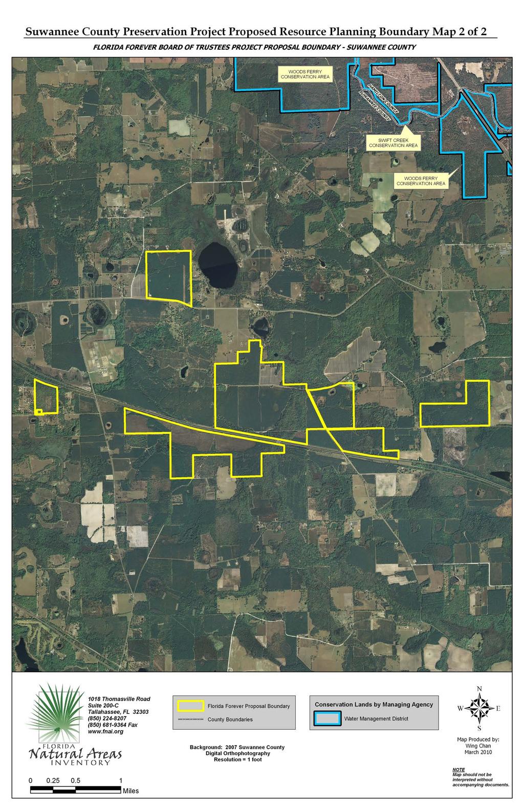
16 Suwannee County Preservation Project (Suwannee County) Resource Planning Boundary The Suwannee County Preservation Project (SCPP), proposed for protection by Michael Carricarte and family, consists of multiple parcels totaling 1,641 acres in Suwannee County. According to a supplement to the application, the family is willing to consider either fee simple or less than fee sale of all or part of the property. Most of the proposal is in northeastern Suwannee County, approximately 3 miles south of the Suwannee River and 4 miles west of the Columbia County line, or 4 miles east of Live Oak. This portion of the proposal, collectively termed the eastern tract, consists of several parcels that are in close proximity but not entirely contiguous and which are crossed from east to west by Interstate 10 (ca. 3.5 miles of frontage). Eighteen miles to the west, 13 miles west of Live Oak, is a 146-acre isolated tract along the Suwannee River just across from Madison County (hereafter, the river tract). Potential benefits of acquiring the property are contributions to recreation (paddling, fishing, hiking) and protection of the water quality of the Suwannee River (as noted in the January Preliminary Evaluation, more than 90% of the property is within Surface Water Protection and Aquifer Recharge areas as measured by the Florida Forever Conservation Needs Assessment); the river itself supports important populations of a number of rare plant and animal species. Proposed Florida Forever Goals and Measures for the Suwannee County Preservation Project are listed at the end of this evaluation. Natural resource values are summarized in the Preliminary Evaluation of January 2010 Florida Forever Proposals. FNAI staff assessed the potential for additions and deletions to the proposal boundary based on interpretation of 2007 one-foot resolution digital photography and information in its Element Occurrence Record and Conservation Lands databases. We recommend no specific additions or deletions but offer the following considerations. Because of its location, the river tract provides the greatest value toward achieving the potential benefits outlined above. This value would be enhanced by expanding the project to include the many miles of unprotected and mostly undeveloped river front forests that extend both upstream and downstream, as well as across from, this relatively small tract (146 GIS acres). However, formal addition potentially could entail thousands of acres in many ownerships. The fragmented nature of the remaining parcels, disturbance to upland vegetation, bisection by Interstate 10, and distance from the river, limit the opportunity for the eastern tract to support rare species or those natural communities considered to be in greatest need of protection. Similar disturbance to most of the surrounding landscape provides little opportunity to delineate additions that would substantially enhance protection of such resources.
17 SUWANNEE COUNTY PRESERVATION PROJECT Application Addendum Section , (4), (9) and (10) Florida Statues FLORIDA FOREVER GOALS & PERFORMANCE MEASURES SECTION (4) GOAL A: ENHANCE THE COORDINATION AND COMPLETION OF LAND ACQUISITION PROJECTS Measure A2: The number of acres protected through the use of alternatives to fee simple acquisition. GOAL B: INCREASE THE PROTECTION OF FLORIDA S BIODIVERSITY AT THE SPECIES, NATURAL COMMUNITY, AND LANDSCAPE LEVELS Measure B1: The number of acres acquired of significant strategic habitat conservation areas. Measure B3: The number of acres acquired of significant landscapes, landscape linkages, and conservation corridors, giving priority to completing linkages. GOAL C: PROTECT, RESTORE, AND MAINTAIN THE QUALITY AND NATURAL FUNCTIONS OF LAND, WATER, AND WETLAND SYSTEMS OF THE STATE. Measure C5: The number of acres acquired that protect surface waters of the state; Measure C8: The number of acres of functional wetland systems protected. GOAL D: ENSURE THAT SUFFICIENT QUANTITIES OF WATER ARE AVAILABLE TO MEET THE CURRENT AND FUTURE NEEDS OF NATURAL SYSTEMS AND THE CITIZENS OF THE STATE Measure D3: The number of acres acquired of groundwater recharge areas critical to springs, sinks, aquifers, other natural systems, or water supply. GOAL F: PRESERVE SIGNIFICANT ARCHAEOLOGICAL OR HISTORIC SITES Measure F2: The increase in the number and percentage of historic and archaeological properties that are in state ownership. GOAL G: INCREASE THE AMOUNT OF FORESTLAND AVAILABLE FOR SUSTAINABLE MANAGEMENT OF NATURAL RESOURCES Measure G1: The number of acres acquired that are available for sustainable forest management. CRITERIA Section (9) and (10), Florida Statutes (9)(a) The project meets multiple goals described in subsection (4). (b) The project is part of an ongoing governmental effort to restore, protect, or develop land areas or water resources. (c)the project enhances or facilitates management of properties already under public ownership. (f) The project contributes to the solution of water resource problems on a regional basis.

18
19
20 Wolfe Creek Forest (Santa Rosa County) Resource Planning Boundary The Wolfe Creek Forest proposal encompasses 10,022 acres (calculated through GIS) in central Santa Rosa County in the western Florida Panhandle. The property is currently owned by Conservation Forestry, Inc. and is proposed for full fee acquisition. The proposal is located generally between Blackwater River State Forest to the east, and Naval Air Station Whiting Field to the southwest. It shares 5.7 miles of it southern boundary with two disjunct tracts of the State Forest, forming a connection between all three tracts. Wolfe Creek Forest primarily supports pine plantations on lands that historically supported upland pine forest and sandhills. Natural communities on the property include seepage streams, bottomland forests, floodplain swamps, upland hardwood forests and seepage slopes. The property is within the watersheds of Big Coldwater Creek and Big Juniper Creek, two major tributaries to the Blackwater River, designated by Florida DEP as an Outstanding Florida Water ( [27] F.S.). These creeks and the River support numerous rare plants and aquatic fauna. A more detailed analysis of the natural resources within the proposal can be found in the FNAI report, Preliminary Evaluations of the January 2010 Florida Forever Proposals, submitted to ARC in February We suggest12 additions to the boundary to further the Florida Forever Goals, Measures, and Criteria (attached) that Wolfe Creek Forest proposes to meet. The suggested additions total 1,308 acres. A1 is 343 acres at the eastern most edge of the proposal that, if added, widens the connection with the State Forest to the east. A1 shares 2 miles of its boundary with the State Forest; the existing proposal shares one mile. The uplands on property are highly altered, with approximately 115 acres of old pastures now planted with pines in the south, and dense pine planation in the north segment of Rattlenake Spring Branch crosses the property and has associated with it about 40 acres of bottomland forest; the Branch flows eastward into Big Juniper Creek. Including A1 would simplify the management boundary of the State Forest and increase watershed protection for Big Juniper, and ultimately, Blackwater River. A2 is 213 acres that joins proposal s eastern boundary. It includes three steepheads that flow into Earnest Mill Creek; these appear to have intact bottomland forest, although the steep upland slopes appear to have been logged in the past and are now planted in pines. About 20 acres in the south of A2 appear to be natural upland pine forest or sandhill: the remaining uplands are in pine plantation. The property has 0.7 mile County Road 191/Munson Highway frontage.
21 A3 is 38 acres; approximately 8 acres is pasture with one small structure, possibly a home. The remaining acres have supported large pines at least since 1995, and could possibly be good quality upland pine forest or sandhill. The property has 0.1 miles of County Road 191/Munson Highway frontage. A3 would serve to simplify the management boundary of the property. A4 is a 51 acre an inholding in the current proposal and supports pine plantation on uplands similar to, and contiguous with, those within the proposal. A5 is a 4 acre wedge between a small county road to the west and a tributary to Big Coldwater Creek to the east. It is on the slope of the tributary; this wedge juts into the existing proposal. This addition would greatly simplify the existing proposal boundary and would serve to protect the tributary slope. A6 is 95 acres of good quality bottomland forest and floodplain swamp that fronts Big Coldwater Creek for 0.3 three miles on the Creek s western side, and occurs on both sides of the Creek for another.25 miles. A6 enhances the proposal s connection to the State Forest. A7 is an 82 acre inholding within the proposal boundary that includes land on both sides of a 0.5 mile segment of Big Coldwater Creek. The property appears to have good quality bottomland forest, floodplains swamp on about 35 acres, about 15 acres of upland hardwood forest, and the remainder is in pine plantation on uplands similar to that within the proposal. A8 is 331 acres adjoining the western boundary of the proposal that appears to support good quality natural sandhill of about 150 acres in the south and a relatively large upland hardwood forest of about 80 acres in the north. The remainder of the property is in pine plantation on uplands similar to what appears to be within the proposal. A8 would provide a wider buffer for Big Coldwater Creek. A9 is approximately 8 acres of upland hardwood forest and bottomland forest on the western edge of the Big Coldwater Creek basin, and would serve to simplify the proposal s management boundary. A10 is 61 acres that connects the proposal s westernmost, outlying parcel with the main proposal boundary. The property would also further protection of aquatic resources. The property encompasses both sides of 0.2 miles of the West Fork of Big Coldwater Creek and 0.2 miles of Big Coldwater Creek. A10 is on relatively low lying land between the two creeks, just north of their confluence. It supports bottomland forest associated with both creeks, some hardwood forest on upper slopes, and what appears to be small areas of pine plantation in what was once likely bottomland forest or mesic flatwoods.
22 A11 is 13 acres of what appear to be good quality, if somewhat overgrown, upland pine forest between the proposal (to the south) and Springhill Road (to the north), and has 0.3 miles of road frontage. A12 is north of Springhill road, between the road and the proposal. It supports 12 acres of bottomland forest along 0.1 mile of the eastern bank of Big Coldwater Creek. It fronts Springhill Road for 0.2 mile. There is river access from Springhill Road on this property; a vehicle turnabout is visible near the road, and the site is designated on a Santa Rosa County canoe trail map as the Wagner Bridge canoe launch. According to county property appraiser data, the site is privately owned. A13 is 55 acres of what appears to be relatively good quality upland pine forest, upland hardwood forest, and bottomland forest on a gentle west-facing slope of Big Coldwater Creek. The property is contiguous with the proposal on its northern and western boundaries. A 5 acre ruderal clearing is included. A potential future addition is approximately 3,600 acres north of the proposal along the main branch of Big Coldwater Creek, known as the East Fork of the creek. This property encompasses both sides of the Creek, and increases connectivity of the current proposal with the State Forest, which contains the headwaters and several miles of the creek run. If this potential future addition and the current proposal were protected, then the entire length of this large, high quality creek would be conserved. Such a large addition, however, is outside the scope of this Resource Planning Boundary, so it not recommended as an addition at this time. We propose no deletions from the proposal.
23 WOLFE CREEK FOREST Application Addendum Section , (4), (9) and (10) Florida Statues FLORIDA FOREVER GOALS & PERFORMANCE MEASURES SECTION (4) GOAL A: ENHANCE THE COORDINATION AND COMPLETION OF LAND ACQUISITION PROJECTS Measure A1: The number of acres acquired through the state's land acquisition programs that contribute to the enhancement of essential natural resources, ecosystem service parcels, and connecting linkage corridors as identified and developed by the best available scientific analysis. Measure A3: The number of shared acquisition projects among Florida Forever funding partners and partners with other funding sources, including local governments and the Federal Government. GOAL B: INCREASE THE PROTECTION OF FLORIDA S BIODIVERSITY AT THE SPECIES, NATURAL COMMUNITY, AND LANDSCAPE LEVELS Measure B6: The percentage increase in the number of occurrences of imperiled species on publicly managed conservation areas. GOAL C: PROTECT, RESTORE, AND MAINTAIN THE QUALITY AND NATURAL FUNCTIONS OF LAND, WATER, AND WETLAND SYSTEMS OF THE STATE. Measure C1: The number of acres of publicly owned land identified as needing restoration, enhancement, and management, acres undergoing restoration or enhancement, acres with restoration activities completed, and acres managed to maintain such restored or enhanced conditions; the number of acres which represent actual or potential imperiled species habitat; the number of acres which are available pursuant to a management plan to restore, enhance, repopulate, and manage imperiled species habitat; and the number of acres of imperiled species habitat managed, restored, enhanced, repopulated, or acquired. Measure C2: The percentage of water segments that fully meet, partially meet, or do not meet their designated uses as reported in the Department of Environmental Protection's State Water Quality Assessment 305(b) Report;. Measure C4: The number of acres acquired that protect natural floodplain functions. Measure C5: The number of acres acquired that protect surface waters of the state; Measure C6: The number of acres identified for acquisition to minimize damage from flooding and the percentage of those acres acquired. Measure C8: The number of acres of functional wetland systems protected. GOAL D: ENSURE THAT SUFFICIENT QUANTITIES OF WATER ARE AVAILABLE TO MEET THE CURRENT AND FUTURE NEEDS OF NATURAL SYSTEMS AND THE CITIZENS OF THE STATE Measure D1: The number of acres acquired which provide retention and storage of surface water in naturally occurring storage areas, such as lakes and wetlands, consistent with the maintenance of water resources or water supplies and consistent with district water supply plans. Measure D2: The quantity of water made available through the water resource development component of a district water supply plan for which a water management district is responsible.
24 Measure D3: The number of acres acquired of groundwater recharge areas critical to springs, sinks, aquifers, other natural systems, or water supply. GOAL E: INCREASE NATURAL RESOURCE-BASED PUBLIC RECREATIONAL AND EDUCATIONAL OPPORTUNITIES Measure E1: The number of acres acquired that are available for natural resource-based public recreation or education. Measure E2: The miles of trails that are available for public recreation, giving priority to those that provide significant connections including those that will assist in completing the Florida National Scenic Trail. Measure E3: The number of new resource-based recreation facilities,by type, made available on public land. GOAL F: PRESERVE SIGNIFICANT ARCHAEOLOGICAL OR HISTORIC SITES Measure F1: The increase in the number of and percentage of historic and archaeological properties listed in the Florida Master Site File or National Register of Historic Places which are protected or preserved for public use. GOAL G: INCREASE THE AMOUNT OF FORESTLAND AVAILABLE FOR SUSTAINABLE MANAGEMENT OF NATURAL RESOURCES Measure G1: The number of acres acquired that are available for sustainable forest management. Measure G4: the percentage and number of acres identified for restoration actually restored by reforestation. The number of acres acquired that are available for sustainable forest management. GOAL H: INCREASE THE AMOUNT OF OPEN SPACE AVAILABLE IN URBAN AREAS. Measure H1: The percentage of local governments that participate in land acquisition programs and acquire open space in urban cores. Measure H2: The percentage and number of acres of purchases of open space within urban service areas. CRITERIA Section (9) and (10), Florida Statutes (9) (a) The project meets multiple goals described in subsection (4). (c)the project enhances or facilitates management of properties already under public ownership.(d) The project has significant archaeological or historic value. (f) The project contributes to the solution of water resource problems on a regional basis.

25
EXHIBIT A. FY Management Accomplishment Summary for Okaloacoochee Slough State Forest
 EXHIBIT A 2001-2011 Management Accomplishment Summary for Okaloacoochee Slough State Forest PROGRAM ACTIVITY 01/02 02/03 03/04 04/05 05/06 06/07 07/08 08/09 09/10 10/11 11/12 TOTAL Reforestation/ Restoration
PEACE RIVER MANASOTA REGIONAL WATER SUPPLY AUTHORITY Orange Hammock Ranch Conservation Fact Sheet
 PEACE RIVER MANASOTA REGIONAL WATER SUPPLY AUTHORITY Orange Hammock Ranch Conservation Fact Sheet Authority s Regional Water Supply Infrastructure The RV Griffin Reserve (RVG) property is owned by the
Land Use and Management Plan for Flying Eagle Preserve. Executive Summary
 Land Use and Management Plan for Flying Eagle Preserve August 2011 SWFWMD August 2011 Table of Contents... 1 Flying Eagle Preserve at a Glance... 1 Planning Process... 2 and... 6 Resource Protection and
Flagler County Blueway
 Flagler County Blueway Flagler and Volusia Counties Partnerships Purpose for State Acquisition areas have creeks associated with them. Boating, Public acquisition of this project will contribute to canoeing
1. GENERAL DESCRIPTION OF LAND USE / COVER TYPES (SEE GENERAL DESCRIPTIONS ON PAGE 7) A 2. ADJACENT LANDS & EASEMENTS 3. FAMILY AGRICULTURAL LEGACY
 A 2. ADJACENT LANDS & EASEMENTS 3. FAMILY AGRICULTURAL LEGACY") CONSERVATION EASEMENT PROJECT: COUNTY: NAME OF LANDOWNER: CELL/OFFICE PHONE: NAME OF FARM / SITE MANAGER: CELL/OFFICE PHONE: GENERAL DESCRIPTION OF LAND USE / COVER TYPES (SEE GENERAL DESCRIPTIONS ON PAGE
CONSERVATION EASEMENT PROJECT: COUNTY: NAME OF LANDOWNER: CELL/OFFICE PHONE: NAME OF FARM / SITE MANAGER: CELL/OFFICE PHONE: GENERAL DESCRIPTION OF LAND USE / COVER TYPES (SEE GENERAL DESCRIPTIONS ON PAGE
CONSERVATION 20/20 OVERVIEW. Cathy Olson, Conservation Lands Manager Lee County Department of Parks and Recreation
 CONSERVATION 20/20 OVERVIEW Cathy Olson, Conservation Lands Manager Lee County Department of Parks and Recreation What is Conservation 20/20? Lee County s current environmentally sensitive land acquisition
Chapter 10 Natural Environment
 Chapter 10 Natural Environment Existing Conditions The Natural Environment Element addresses the protection, conservation, preservation, and restoration of the natural resources the Bayview Ridge Subarea,
Nassau County 2030 Comprehensive Plan. Conservation Element (CS) Goals, Objectives and Policies. Goal
 Goals, Objectives and Policies. Goal") (CS) Goal Conserve, and protect and enhance the natural resources that are important to the economy, health, and quality of life of County residents, ensuring that adequate resources are available for
(CS) Goal Conserve, and protect and enhance the natural resources that are important to the economy, health, and quality of life of County residents, ensuring that adequate resources are available for
Natural Resource Value of Edison Farms/Agripartners. Presented by: Jessica Stubbs, Natural Resources Specialist
 Natural Resource Value of Edison Farms/Agripartners Through Research and Science Presented by: Jessica Stubbs, Natural Resources Specialist Introduction to Edison Farms Almost 4,000 acres Within Estero
Nassau County 2030 Comprehensive Plan. Conservation Element (CS) Goals, Objectives and Policies. Goal
 Goals, Objectives and Policies. Goal") (CS) Goal Conserve, protect and enhance the natural resources that are important to the economy, health, and quality of life of County residents, ensuring that adequate resources are available for future
(CS) Goal Conserve, protect and enhance the natural resources that are important to the economy, health, and quality of life of County residents, ensuring that adequate resources are available for future
Conservation Assessment of the Neuse River Lowgrounds and Mill Creek Watersheds in Johnston County
 Conservation Assessment of the Neuse River Lowgrounds and Mill Creek Watersheds in Johnston County Prepared by Leigh Ann Cienek and Jon Scott Triangle Land Conservancy Funding provided by the NC Attorney
Oshawa Creek Watershed Management Plan EXECUTIVE SUMMARY
 Oshawa Creek Watershed Management Plan EXECUTIVE SUMMARY The Central Lake Ontario Conservation Authority (CLOCA) has recognized the need to prepare comprehensive management strategies for all of its watersheds.
ENVIRONMENTAL FEATURES OF THE TOWN
 Town of Aurora Map 1 11 12 ENVRONMENTAL FEATURES TOPOGRAPY Maps 1 and 2 show the locations of important natural features of the Town of Aurora. Aurora is located in the Alleghany Plateau, a region of broad,
Charlotte Harbor SWIM Plan Update Proposed Quantifiable Objectives and Management Actions, January 2019
 Management Actions One of the goals of this SWIM plan is to identify strategic initiatives that will address the major issues and drivers and provide management actions that will improve and maintain the
COASTAL CONSERVANCY. Staff Recommendation March 25, 2004 NCCP PROGRAM IMPLEMENTATION: SAN DIEGO RIVER CALMAT PROPERTY PHASE 2
 COASTAL CONSERVANCY Staff Recommendation March 25, 2004 NCCP PROGRAM IMPLEMENTATION: SAN DIEGO RIVER CALMAT PROPERTY PHASE 2 File No. 03-137 Project Manager: Marc Beyeler RECOMMENDED ACTION: Authorization
Crow s Foot Conservation Area Feasibility Study
 Crow s Foot Conservation Area Feasibility Study Site Opportunities Presentation Trust For Public Land PRESENTED BY SmithGroup JJR August, 2002 McHenry County Conservation District Boone County Conservation
I 3. MEETING DATE: a. MANAGEMENT RECOMMENDATIONS: WHY ACTION IS NECESSARY: Required by Lee County Ordinance II
 Lee County Board of County Commissioners Agenda Item Summary Blue Sheet No. 20021239 1. REQUESTED MOTION: ACTION REQUESTED: Approve the recommendations of the Conservation Lands Acquisition and Stewardship
ANCR INDIVIDUAL RESPONSES SUMMARY: 2/11/04 WATER RESOURCES GOALS AND OBJECTIVES
 ANCR INDIVIDUAL RESPONSES SUMMARY: 2/11/04 WATER RESOURCES GOALS AND OBJECTIVES Goal 1: Protect the health and safety of the Dane County population. a. Prevent development that may have an adverse effect
Goose Creek Watershed Assessment Summary October 2003
 Goose Creek Watershed Assessment Summary October 2003 The Goose Creek Watershed The Goose Creek watershed is 385 square miles, covering nearly half of Loudoun County and one-quarter of Fauquier County
LOWER DRUM PLANNING UNIT Yuba-Bear River Watershed
 Existing Conditions & Uses Overview Provides open space and recreation opportunities within the Sierra Nevada foothills 1,098 acres in Placer and Nevada Counties 789 acres outside the FERC boundary; 309
$5 Million Enviva Forest Conservation Fund Announces 2016 Conservation Grants
 FOR IMMEDIATE RELEASE Enviva contact: U.S. Endowment contact: Kent Jenkins Jr. Carlton Owen Vice President, Communications President and CEO 240.482.3811 864.233.7646 kent.jenkins@envivabiomass.com carlton@usendowment.org
4 CONSERVED LANDS, PUBLIC LANDS, AND OTHER RECREATIONAL OPPORTUNITIES
 4 CONSERVED LANDS, PUBLIC LANDS, AND OTHER RECREATIONAL OPPORTUNITIES At the time of this study, there are approximately 2,300 acres of conservation land in Grantham, or 12% of the land area. The Town
Final Report of the Riparian Forest Buffer Panel
 Chesapeake Bay Program Final Report of the Riparian Forest Buffer Panel Introduction Findings Land Use-Specific Findings On Agricultural Land On Forested Land On Developed and Developing Lands Recommendations
COASTAL CONSERVANCY. Staff Recommendation June 16, 2005 ESTERO AMERICANO NATURE PRESERVE ENHANCEMENT PROJECT
 COASTAL CONSERVANCY Staff Recommendation June 16, 2005 ESTERO AMERICANO NATURE PRESERVE ENHANCEMENT PROJECT File No. 05-017 Project Manager: Richard Retecki RECOMMENDED ACTION: Authorization to disburse
EXECUTIVE SUMMARY. Introduction
 Introduction In September 2003, Hillsborough County retained Ayres Associates Inc to update the Watershed Management Plan (WMP) for the Rocky/Brushy Creek watershed, which was originally prepared in 2001.
Wetland and Watershed Management Planning FAQ
 Wetland and Watershed Management Planning FAQ Jon Kusler, Ph.D., Esq., Jennifer Brady-Connor, Nan Stolzenburg Association of State Wetland Managers 2001 This summary was prepared for the Institute for
Executive Summary North Ranch Sector Plan, Long-term Master Plan Environmental Plan Peer Review
 Executive Summary North Ranch Sector Plan, Long-term Master Plan Environmental Plan Peer Review Peer Review Team: Jay Exum, PhD ~ Richard Hilsenbeck, PhD ~ Reed Noss, PhD Purpose: In the process of considering
Conservation, Open Space & Groundwater Recharge Element
 Conservation, Open Space & Groundwater Recharge Element GOAL 1 ESTABLISH AND MAINTAIN AN INTEGRATED AND URBAN-DEFINING OPEN SPACE NETWORK THAT PROTECTS AND CONSERVES KEY ENVIRONMENTAL FEATURES. Objective
County of Sonoma Agenda Item Summary Report
 County of Sonoma Agenda Item Summary Report Agenda Item Number: 55 (This Section for use by Clerk of the Board Only.) Clerk of the Board 575 Administration Drive Santa Rosa, CA 95403 To: Board of Supervisors
Appendix I. Potential Adverse Change to Wetland Function Methodology and Results
 Appendix I Potential Adverse Change to Wetland Function Methodology and Results Technical Memorandum North Florida Regional Water Supply Plan Potential Adverse Change to Wetland Function January 3, 2017
LIMITED ENVIRONMENTAL REVIEW
 Division of Environmental and Financial Assistance Office of Financial Assistance Water Resource Restoration Sponsor Program LIMITED ENVIRONMENTAL REVIEW A. Project Identification Project Name: Project
D Olive Watershed. Path Toward Restoration
 D Olive Watershed Path Toward Restoration Water is the most critical resource issues of our lifetime and our children s lifetime. The health of our waters is the principal measure of how we live on the
Chapter 6: Land Use/Land Cover
 Chapter 6: Land Use/Land Cover The general historic land use pattern that emerged in Burt Township is similar to many other communities across the Upper Peninsula. Commercial fishing and lumbering were
Yamhill County Comprehensive Land Use Plan
 Yamhill County Comprehensive Land Use Plan Revised Goals And Policies - Adopted December 30, 1996 Incorporating Goal and Policy amendments through Ordinance 618 SECTION II. The Land and Water A. Agricultural
How Much Habitat Is Enough? How Much Disturbance is Too Much?
 How Much Habitat Is Enough? How Much Disturbance is Too Much? Jocelyn Sherwood Canadian Wildlife Service - Ontario January 27 th, 2017 Page 2 April 19, 2017 Page 3 April 19, 2017 Grasslands Forest Wetlands
awetlands aprairie aforests ahabitat for Fish, Game & Wildlife
 Rec. H1 priority land habitats pp. 63-67 Priority areas identified in integrated mapping assessing critical land habitat and threats to habitat pp.33-63 o Mapping is scalable for use in localized areas
Comments Regarding FDOT Tampa Bay to Northeast Florida Study Area Concept Report May 28, 2013
 Comments Regarding FDOT Tampa Bay to Northeast Florida Study Area Concept Report May 28, 2013 These comments were submitted to FDOT on behalf of 1000 Friends of Florida, Audubon Florida, St. Johns Riverkeeper,
VEGETATIVE, WATER, FISH AND WILDLIFE RESOURCES POLICIES
 VEGETATIVE, WATER, FISH AND WILDLIFE RESOURCES POLICIES The County will: GOALS AND OBJECTIVES 1.1 Conserve, Enhance, Protect, Maintain and Manage Vegetative, Water, Fish and Wildlife Resources Promote
P ARISH OF EAST B ATON ROUGE, L OUISIANA BREC S TRATEGIC P LAN
 CHAPTER 9 CULTURAL, HISTORICAL AND NATURAL RESOURCE MANAGEMENT PLAN INTRODUCTION This chapter is a digest version of a Natural Resource, Cultural and Historical Document authored by BREC Staff over the
2015 Reinvest in Minnesota (RIM) Reserve Wetlands Program
 Reserve Wetlands Program") 2015 Reinvest in Minnesota (RIM) Reserve Wetlands Program Site Evaluation Form Instructions Document 12/31/14 This instructions document is to be used for guidance in completing the Site Evaluation Form
2015 Reinvest in Minnesota (RIM) Reserve Wetlands Program Site Evaluation Form Instructions Document 12/31/14 This instructions document is to be used for guidance in completing the Site Evaluation Form
CLEARWATER TOWNSHIP WATER QUALITY ACTION PLAN
 CLEARWATER TOWNSHIP WATER QUALITY ACTION PLAN Elk-River-Chain-of-Lakes Gaps Analysis Project The Watershed Center Grand Traverse Bay Michigan Department of Environmental Quality July 2011 Purpose The Grand
Bluff Creek One Water
 Bluff Creek One Water The Bluff Creek Watershed has no lakes within its boundaries. As the westernmost watershed within the District, land use changes from agricultural to residential have occurred relatively
PRELIMINARY EVALUATIONS OF THE MAY 2018 FLORIDA FOREVER PROPOSALS
 PRELIMINARY EVALUATIONS OF THE MAY 2018 FLORIDA FOREVER PROPOSALS Prepared by Florida Natural Areas Inventory 1018 Thomasville Road Suite 200-C Tallahassee, FL 32303 Blank Page Preliminary Evaluations
Environmental Resource Inventories. What are ERIs? Significance of information How to use them
 Environmental Resource Inventories What are ERIs? Significance of information How to use them Environmental Resource Inventory - ERI Compiled by the environmental commission Information about the natural
Town of Northborough. History
 Town of Northborough Scenery The Assabet River enters Northborough from Westborough and forms the town boundary for a distance of approximately 6,000 feet. The river in this area flows through Indian Meadow
Public Notice Corps of Engineers
 Public Notice US Army Corps of Engineers Memphis District REPLY TO ATTN: Roger Allan U.S. Army Corps of Engineers 167 North Main Street, Room B-202 Memphis, Tennessee 38103-1894 Telephone: (901) 544-3682
Appendix E : Guidelines for Riparian Buffer Areas
 Appendix E : Guidelines for Riparian Buffer Areas This document should be read in conjunction with the CRCA Planning Policy. 1.0 PURPOSE The purpose of this document is to summarize the recommendations
TYPICAL CONTENTS OF A SITE-SPECIFIC NATURAL RESOURCE AND WOODLAND STAND DELINEATION MAP:
 TYPICAL CONTENTS OF A SITE-SPECIFIC NATURAL RESOURCE AND WOODLAND STAND DELINEATION MAP: A Site Context Map (1"=200') for vicinity within 1000' of the property Scale of map (to match scale of submitted
COASTAL CONSERVANCY. Staff Recommendation December 11, 2003 LAGUNA DE SANTA ROSA: RESTORATION MANAGEMENT PLAN AND PHASE II SEDIMENTATION STUDY
 COASTAL CONSERVANCY Staff Recommendation December 11, 2003 LAGUNA DE SANTA ROSA: RESTORATION MANAGEMENT PLAN AND PHASE II SEDIMENTATION STUDY File No. 03-138 Project Manager: Maxene Spellman RECOMMENDED
SW-71 BOYD HILL NATURE PRESERVE MITIGATION PLAN
 SW-71 BOYD HILL NATURE PRESERVE MITIGATION PLAN BACKGROUND INFORMATION Project SWIM? Aquatic Control? Exotic Control? Mitigation Bank? Type No No Yes No Mitigation Wetland and upland enhancement Type Landowner
Model Riparian Buffer Ordinance.
 Model Riparian Buffer Ordinance. This is a sample riparian buffer ordinance written as an amendment to an existing zoning ordinance. This ordinance complies with the state minimum standards for river corridor
Summary of Management Recommendations
 Location and Description This property is owned by Anthony Day, 14426 NW 83 rd Lane, Alachua, FL 32615. The property is located in Section 18, Township 1 North, Range 6 East, in eastern Jefferson County,
1. Executive Summary. Valley Branch and Trout Brook Watershed Grishma Shrestha
 1. Executive Summary Introduction This report intends to explore various environmental characteristics in the Valley Branch and Trout Brook watersheds, Washington County. The report primarily emphasizes
Stormwater Successes on a Local and Regional Scale in South Florida
 Stormwater Successes on a Local and Regional Scale in South Florida 2017 Florida Stormwater Association Annual Conference Lake Worth Lagoon Bird Island Lake Butler Rod A. Braun Principal Scientist/Section
Public Notice ISSUED: EXPIRES:
 SPONSOR: City of Superior Public Notice ISSUED: EXPIRES: REFER TO: 2015-04234-WMS SECTION:404 - Clean Water Act 1. WETLAND COMPENSATORY MITIGATION BANK PROPOSAL 2. SPECIFIC INFORMATION. SPONSOR S ADDRESS:
DEKALB COUNTY STORMWATER MANAGEMENT PLAN PHASE 2
 DEKALB COUNTY STORMWATER MANAGEMENT PLAN PHASE 2 Introduction DeKalb County, Illinois, located approximately 50 miles west of Lake Michigan, is rectangular in shape, with a north/south dimension of 36
STAFF REPORT. Permit Number: Tallman. Kitsap County Board of Commissioners; Kitsap County Planning Commission
 STAFF REPORT Permit Number: 15 00742 Tallman DATE: November 9, 2015 TO: FROM: RE: Kitsap County Board of Commissioners; Kitsap County Planning Commission Katrina Knutson, AICP, Senior Planner, DCD and
City of Winter Haven Water Sustainability Program. Mike Britt, P.E., Natural Resources Division
 Florida Stormwater Association EXCELLENCE AWARD for STORMWATER PROGRAMS and PROJECTS NOMINATION FORM I. Nomination Information Nomination Category (please check only one box): Program (Department/Division)
INDIAN CREEK WATERSHED PLAN EXECUTIVE SUMMARY
 INDIAN CREEK WATERSHED PLAN EXECUTIVE SUMMARY The Indian Creek Watershed covers a 38 square mile area in southern Lake County, Illinois that drains 24,116 acres before discharging into the Des Plaines
*Tell the Forest Service about how the Wesser Bald area appears natural.
 Wesser Bald 6,642 acres The Wesser Bald area is located in Swain and Macon Counties on the Nantahala Ranger District of the Nantahala National Forest. NC1365 and a powerline corridor separate the Wesser
COASTAL CONSERVANCY. December 2, 2004 SAN DIEGO NCCP PROGRAM IMPLEMENTATION: MONTE VISTA RANCH. File No Project Manager: Marc Beyeler
 COASTAL CONSERVANCY Staff Recommendation December 2, 2004 SAN DIEGO NCCP PROGRAM IMPLEMENTATION: MONTE VISTA RANCH File No. 03-137 Project Manager: Marc Beyeler RECOMMENDED ACTION: Authorization to disburse
TAC CHARRETTE WORKBOOK Ecosystem Management and Sustainable Forestry Practices
 For Discussion Purposes TAC CHARRETTE WORKBOOK Ecosystem Management and Sustainable Forestry Practices NEW JERSEY HIGHLANDS COUNCIL March 28, 2006 1 Overview of RMP Goals and Structure NEW JERSEY HIGHLANDS
11. Prioritizing Farmlands for Future Protection
 11. Prioritizing Farmlands for Future Protection Identification of Important Farmlands in Putnam County I n order to implement this Plan successfully, Putnam County decision-makers will have to take advantage
ELK RAPIDS TOWNSHIP WATER QUALITY ACTION PLAN
 ELK RAPIDS TOWNSHIP WATER QUALITY ACTION PLAN Elk-River-Chain-of-Lakes Gaps Analysis Project The Watershed Center Grand Traverse Bay Tip of the Mitt Watershed Council Michigan Department of Natural Resources
Lee County Artesian Well Abandonment Project
 Lee County Artesian Well Abandonment Project Background Uncontrolled, improperly constructed, deteriorated or abandoned artesian (free-flowing) wells can have an adverse impact on the quantity and quality
SECTION 3 NATURAL RESOURCES
 SECTION 3 NATURAL RESOURCES The natural environment plays a large role in planning for future development. Environmental conditions, such as topography, wetlands, floodplains, and water bodies, can often
Bear Creek Watershed Riparian Canopy Assessment
 Bear Creek Watershed Riparian Canopy Assessment Introduction This report describes the methods employed in, and results of, the project to estimate riparian canopy cover of Bear Creek and its major tributaries
(1)(A)Inventory of the following existing natural resources on the USFSP Campus or within the context area adjacent to the University.
(A)Inventory of the following existing natural resources on the USFSP Campus or within the context area adjacent to the University.") 13. 6C-21.208 CONSERVATION ELEMENT Information Sources George F. Young, Interview notes, June 2002 Sasaki Associates, Inc., interview notes, April, 2000 Interviews between DRMP Staff and USF Staff, May,
13. 6C-21.208 CONSERVATION ELEMENT Information Sources George F. Young, Interview notes, June 2002 Sasaki Associates, Inc., interview notes, April, 2000 Interviews between DRMP Staff and USF Staff, May,
University of Florida Conservation Area Land Management Plan Bat House Woods
 University of Florida Conservation Area Land Management Plan Bat House Woods Introduction Bat House Woods is the unofficial name for the 8.5 acre wooded area adjacent to Physical Plant greenhouses and
West Fork White River Watershed Conservation Map Summaries. Prepared for the Beaver Watershed Alliance. By the Watershed Conservation Resource Center
 West Fork White River Watershed Conservation Map Summaries Prepared for the Beaver Watershed Alliance By the Watershed Conservation Resource Center November 2014 The Watershed Conservation Resource Center
Environmental Assessment
 United States Department of Agriculture Forest Service January 2013 Environmental Assessment Lake and Santa Rosa Counties Land Sale National Forests in Florida Santa Rosa and Lake Counties, Florida For
Public Notice. US Army Corps of Engineers Fort Worth District. Applicant: Mill Branch Stream Mitigation Bank. Permit Application No.
 Public Notice US Army Corps of Engineers Fort Worth District Applicant: Mill Branch Stream Mitigation Bank Permit Application No.: Date: November 10, 2010 The purpose of this public notice is to inform
TEN-YEAR LAND MANAGEMENT PLAN TWIN RIVERS STATE FOREST
 TEN-YEAR LAND MANAGEMENT PLAN FOR THE TWIN RIVERS STATE FOREST HAMILTON, MADISON, AND SUWANNEE COUNTIES PREPARED BY THE FLORIDA DEPARTMENT OF AGRICULTURE AND CONSUMER SERVICES FLORIDA FOREST SERVICE APPROVED
PIGEON RIVER COUNTRY MANAGEMENT UNIT COMPARTMENT REVIEW PRESENTATION COMPARTMENT #17 ENTRY YEAR: 2001
 PIGEON RIVER COUNTRY MANAGEMENT UNIT COMPARTMENT REVIEW PRESENTATION COMPARTMENT #17 ENTRY YEAR: 2001 Compartment Acreage: 1838 County: CHEBOYGAN Revision Date: August 17, 1999 (August 20, 2008) Stand
BMPs TO CONSERVE WOODED AREAS AT THE SUBDIVISION LEVEL
 BMPs to Conserve Wooded Areas 31 BMPs TO CONSERVE WOODED AREAS AT THE SUBDIVISION LEVEL Audience This section is primarily directed toward: local units of government, landowners and developers, builders
DAKOTA COUNTY SOIL AND WATER CONSERVATION DISTRICT COMPREHENSIVE PLAN
 DAKOTA COUNTY SOIL AND WATER CONSERVATION DISTRICT COMPREHENSIVE PLAN 2011-2015 4100 220 th Street West, Suite 102 Farmington, MN 55024 651-480-7777 www.dakotacountyswcd.org I. INTRODUCTION A. Purpose
NATURAL RESOURCES Vision Statement
 NATURAL RESOURCES Vision Statement Citizen and local government practices reflect good stewardship of the water, air and earth. Air and water quality are preserved and cold water springs protected. Light
Cannon River One Watershed, One Plan. POLICY COMMITTEE MEETING January 10, 2018 Rice County Government Center Faribault, MN
 Cannon River One, One Plan POLICY COMMITTEE MEETING January 10, 2018 Rice County Government Center Faribault, MN TASK Task 1. Aggregate Existing Physical & Spatial Data 1A. Create project maps 1B. Meeting
Florida Forever. Project Ranking Support Analyses. Documentation
 Florida Forever Project Ranking Support Analyses Documentation Florida Natural Areas Inventory November 2016 Funded by the Florida Department of Environmental Protection, Division of State Lands Florida
Why Is The Hillsborough River Watershed Important? A Practice Timed Writing Exercise
 Why Is The Hillsborough River Watershed Important? A Practice Timed Writing Exercise Essential Question: Why is the Hillsborough River Watershed important? Objective: Students will write an expository
THE TOWN II. RESOURCES GEOGRAPHY
 THE TOWN II. RESOURCES GEOGRAPHY The Town of Mount Holly is a rural Vermont town surrounded by mountains, as its name suggests. With an estimated 2005 population of 1,236 (US Census Bureau, Population
Public Notice ISSUED: October 16, 2017 EXPIRES: November 15, 2017
 SPONSOR: REFER TO: Wisconsin Department of Natural Resources (WDNR): Wisconsin Wetland Conservation Trust In-Lieu Fee (ILF) program MVP-2013-00984-RMG Public Notice ISSUED: October 16, 2017 EXPIRES: November
KINGS RIVER PLANNING UNIT Kings River Watershed
 Existing Conditions & Uses Overview Remote parcel in rugged canyon with adjoining whitewater rafting base camps 100 acres in Fresno County The Kings River Planning Unit is outside any FERC Project boundary
How Much Habitat is Enough?
 How Much Habitat is Enough? Canadian Wildlife Service 2017 Third Edition Page 2 April 19, 2017 Grasslands Forest Wetlands Riparian & Watershed Page 3 April 19, 2017 Significant impairment in stream At
Tom Sherman Land Acquisition
 1307 L Street, Aurora, NE 68818 402-694-5535 ppri@hamilton.net www.prairieplains.org Tom Sherman Land Acquisition 1. 2. Scenic native prairie and Platte River ecosystem preservation: As a part of its Ribbons
Hillsborough County s E.L.A.P.P Program
 Hillsborough County s E.L.A.P.P Program What is E.L.A.P.P? Environmental Lands Acquisition and Protection Program History of E.L.A.P.P. - Voter-approved program initiated in 1987; extended in 1990 and
Ann F. Johnson and Amy Jenkins. September Florida Natural Areas Inventory. Gary R. Knight, Program Director
 A Survey for Federally Listed Plant Species, Invasive Exotic Plant Species, and High Quality Natural Communities on the Beasley Tract, Year 2, Apalachicola National Forest, Florida by Ann F. Johnson and
Proposed Action. A Land-for-Land Exchange between American Land Holdings of Illinois, LLC and the Shawnee National Forest.
 United States Department of Agriculture Forest Service December 2011 Proposed Action A Land-for-Land Exchange between American Land Holdings of Illinois, LLC and the Shawnee National Forest Shawnee National
3.14 VISUAL RESOURCE (SCENERY)
") 3.14 VISUAL RESOURCE (SCENERY) 3.14.1 INTRODUCTION The Lower West Fork analysis area lies in the Bitterroot Mountain Range and is bisected by the West Fork Road (State Highway 473). The Lower West Fork
3.14 VISUAL RESOURCE (SCENERY) 3.14.1 INTRODUCTION The Lower West Fork analysis area lies in the Bitterroot Mountain Range and is bisected by the West Fork Road (State Highway 473). The Lower West Fork
MIDDLE MISSISSIPPI RIVER (MMR) REGIONAL CORRIDOR
 REGIONAL CORRIDOR") MIDDLE MISSISSIPPI RIVER (MMR) REGIONAL CORRIDOR Illinois Missouri General Expense Project Proposal For Comprehensive Analyses of Multi-jurisdictional Use and Management of Water Resources on a Watershed
MIDDLE MISSISSIPPI RIVER (MMR) REGIONAL CORRIDOR Illinois Missouri General Expense Project Proposal For Comprehensive Analyses of Multi-jurisdictional Use and Management of Water Resources on a Watershed
Water Quality Stewardship Plan (WaQSP)
") Salt Lake Countywide Water Quality Stewardship Plan (WaQSP) Natalie Rees Salt Lake County Flood Control & Engineering Division 2008 Watershed Symposium COUNTY RESPONSIBILITY AND AUTHORITY Salt Lake County
Salt Lake Countywide Water Quality Stewardship Plan (WaQSP) Natalie Rees Salt Lake County Flood Control & Engineering Division 2008 Watershed Symposium COUNTY RESPONSIBILITY AND AUTHORITY Salt Lake County
American Tree Farm System Management Plan Template
 American Tree Farm System Management Plan Template State Tree Farm # Tree Farm Property Location Tree Farm Name: Ownership 1 : County: Tax Map ID: Location 2 : State: GPS Coordinates: Tree Farmer Contact
Introduction. What is a River Basin Restoration Priority? Criteria for Selecting a Targeted Local Watershed (TLW) Savannah River Basin Overview
 Savannah River Basin Overview") Savannah River Basin Restoration Priorities 2008 2 TABLE OF CONTENTS Introduction 1 What is a River Basin Restoration Priority? 1 Criteria for Selecting a Targeted Local Watershed (TLW) 2 Savannah River
Savannah River Basin Restoration Priorities 2008 2 TABLE OF CONTENTS Introduction 1 What is a River Basin Restoration Priority? 1 Criteria for Selecting a Targeted Local Watershed (TLW) 2 Savannah River
Municipal Stormwater Management Plan Prepared For The Borough of Cape May Point By Van Note-Harvey Associates VNH File No.
 Municipal Stormwater Management Plan Prepared For The Borough of Cape May Point By Van Note-Harvey Associates 2005 VNH File No. 35317-210-21 Table of Contents Introduction... 3 Goals... 3 Storm water Discussion...
Figure 18. Natural heritage conservation sites for the Dragon Run watershed.
 Figure 18. Natural heritage conservation sites for the Dragon Run watershed. 54 rare resources. Some of these resources have been conserved, either through fee simple purchase or purchase of conservation
Chapter 4 - Land Use Characteristics
 Chapter 4 - Land Use Characteristics Land Divisions and Ownership Most of the private ownership is divided into tracts 10 acres or larger. Large hunt clubs, owning several sections of land are common in
TEN-YEAR LAND MANAGEMENT PLAN BABCOCK RANCH PRESERVE
 TEN-YEAR LAND MANAGEMENT PLAN FOR THE BABCOCK RANCH PRESERVE CHARLOTTE COUNTY PREPARED BY: THE FLORIDA DEPARTMENT OF AGRICULTURE AND CONSUMER SERVICES FLORIDA FOREST SERVICE APPROVED ON TEN-YEAR LAND MANAGEMENT
APPENDIX H: SFEIS FLOODPLAIN IMPACT ANALYSIS SECTION
 TH 36/STH 64 St. Croix River Crossing 2005 Water Resources Preliminary Design Report APPENDIX H: SFEIS FLOODPLAIN IMPACT ANALYSIS SECTION within the project area. Other methods of attaining this reduction
Community Benefits of Land Restoration
 Community Benefits of Land Restoration Introducing Green Infrastructure for Coastal Resilience Matt Fulda, Acting Director Monroe May 23 rd, 2017 Avery Point Campus, University of Connecticut Easton Trumbull
North Ranch Sector Plan
 North Ranch Sector Plan Long Term Master Plan Public Scoping Meeting 7 January 2014 What Is My Role Today? 1. Sign In 2. Review Process and Purpose Boards 3. Welcome @ 4:00 pm by County Commissioner Hawkins