Quil Ceda Creek Casino Project Archaeological Monitoring and Treatment Plan
|
|
|
- Jack Hunt
- 5 years ago
- Views:
Transcription
1 Quil Ceda Creek Casino Project Archaeological Monitoring and Treatment Plan Prepared for: The Tulalip Tribes th Avenue NE Tulalip, Washington Prepared by: Dave Iversen, M.A., RPA ASM Affiliates, Inc nd Ave. NW, Suite 201 Stanwood, Washington ASM PN February 2018
2 Chapter TABLE OF CONTENTS Page INTRODUCTION... 1 PROJECT DESCRIPTION AND LOCATION... 1 PREVIOUS CULTURAL RESOURCES INVESTIGATIONS... 1 ARCHAEOLOGICAL MONITORING METHODS... 3 ARCHAEOLOGICAL AWARENESS... 3 TREATMENT OF CULTURAL RESOURCES... 3 MONITORING PLAN SUMMARY... 5 UNANTICIPATED DISCOVERY PLAN... 6 INADVERTENT DISCOVERY OF CULTURAL RESOURCES PROTOCOL... 6 INADVERTENT DISCOVERY OF HUMAN REMAINS... 6 QCCC PROJECT CONTACT INFORMATION... 7 REFERENCES... 8 APPENDIX A... 9 LIST OF FIGURES Page Figure 1. Quil Ceda Creek Casino project location QCCC Monitoring and Treatment Plan i
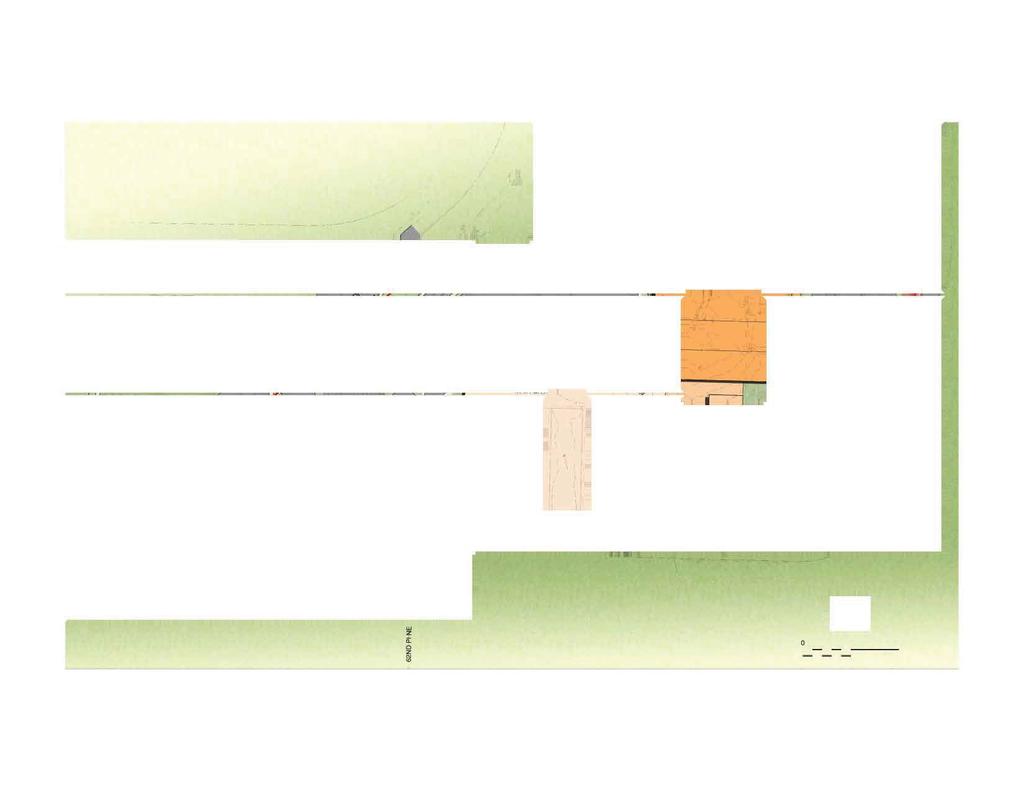
3 INTRODUCTION The purpose of this Archaeological Monitoring and Treatment Plan is to establish archaeological resources monitoring and inadvertent discovery protocols to be used during ground-disturbing construction associated with the Quil Ceda Creek Casino (QCCC) Project on the Tulalip Indian Reservation in Snohomish County, Washington. It includes sections on archaeological monitoring methods, a monitoring plan summary, and a plan for dealing with unanticipated discoveries, in addition to pertinent contact information. PROJECT DESCRIPTION AND LOCATION The Tulalip Tribe envisions the new QCCC Project to be an exciting addition to the overall Quil Ceda development area. The project area is located in Sections 29 and 32 of Township 30 North, Range 5 East, Willamette Base and Meridian (Figure 1). The new casino will replace the existing facility on an adjacent undeveloped site. The casino project will be located on a 12-acre site to the south of the existing Quil Ceda Creek Casino (Appendix A). The current site is being occupied by the Judicial Center which is scheduled for demolition. The proposed project includes the following: construction of approximately 110,000 foot2 (ft.) of casino space including but not limited to gaming floor; back of house areas; employee dining; storage; loading dock; bars and restaurants; signage; emergency generator; raised casino floor; high quality smoke evacuation system; and other amenities. This new facility is expected to have 1,250 slot machine positions, with the ability to expand to 1,500; 17 table games; and two casino bars. In addition, a casual dining restaurant, two fast food venues, a coffee shop, and an entertainment lounge will also be included in the program. The proposed project entails site development of approximately 12 to 14 acres of land including a 1,200-stall parking garage, any site utilities (possible lift station), and 700 surface parking stalls. PREVIOUS CULTURAL RESOURCES INVESTIGATIONS ASM Affiliates, Inc. (ASM) previously conducted a cultural resources assessment associated with the current QCCC Project (Iversen and Steingraber 2016). ASM identified no cultural resources within the project area as a result of the assessment. However, ASM was unable to conduct subsurface investigations in most of the project area s western and northern portions due to existing structures, asphalt pavement, and compact gravel fill. Although the results of the investigation were negative for archaeological resources, there is still a potential for buried cultural resources within the project area based on its location near the Snohomish River Estuary and Quilceda Creek, ethnographic documentation of land use in the project vicinity including village sites along Quilceda Creek, the proximity of previously recorded archaeological sites on similar landforms, and the previous identification of a precontact isolated artifact immediately east of the project area. Cultural resources associated with historic and/or precontact utilization of the project area could be present below fill materials associated with the modern development of the parcel. Additionally, precontact cultural resources could be buried deeply within alluvial deposits in the project area based on the estimated progradation of the Snohomish River Estuary. Based on the potential for encountering archaeological resources, ASM recommended that a professional archaeologist monitor all ground-disturbing activity associated within the QCCC Project. QCCC Monitoring and Treatment Plan 1

4 Figure 1. 2 Quil Ceda Creek Casino project location. ASM Affiliates, Inc.
5 ARCHAEOLOGICAL MONITORING METHODS ASM will provide a professional archaeologist will be on site during construction excavation associated with the project. The on-site archaeological monitor will observe ground disturbances, examining excavation openings and backdirt from excavations for evidence of cultural resource materials while maintaining a safe distance from construction equipment. The monitor may request that construction activities be temporarily halted as necessary to allow photography and recovery of materials and data. Any backdirt may be screened at the discretion of the archaeological monitor. The archaeological monitor will be prepared with the basic equipment needed to perform site documentation, evaluation, and recovery of unanticipated discoveries. The archaeological monitor will follow all safety protocols required of personnel conducting construction activities. The archeological monitor will prepare daily field monitoring verification reports, noting observations, results, and actions taken, as appropriate, concerning the monitoring efforts. Digital photographs will be taken to record the construction activity as well as the character and provenience of any identified cultural resources. A technical report detailing the results of the archaeological monitoring will be completed after the conclusion of all construction excavation associated with the project. ARCHAEOLOGICAL AWARENESS Prior to major construction activities, the project archaeologist will provide sufficient information to the on-site superintendent regarding the laws governing archaeological material and a copy of this Monitoring and Treatment Plan. The project archaeologist will also provide a copy of the contact list and a brief training to the construction crew to familiarize them with potential resources and the Unanticipated Discovery Plan. During the archaeological meeting, the project archaeologist will ensure that the construction foreman and other employees working in the project area understand the roles and responsibilities of the archaeological monitor, as well as the procedures to be followed in the event of an inadvertent discovery when the monitor is not on site. TREATMENT OF CULTURAL RESOURCES If pre-contact or historic-period archaeological materials and/or features are encountered during the course of monitoring activities, all work within at least 30 ft. (10 m) of the find will halt, and the cultural resources representative of the Tulalip Tribes and the QCCC owners representative will be contacted immediately. The treatment of the archaeological materials and their potential National Register of Historic Places (NRHP) eligibility will be determined through coordination with Tribe. If avoidance of the resource is not feasible under project constraints, additional mitigation, including but not limited to NRHP-eligibility test excavations and/or data recovery excavations, may be required. A supplemental treatment plan may be required if potentially NRHP-eligible pre-contact cultural resources are encountered and cannot be avoided. The archaeological monitor will ensure that an area large enough to protect the integrity of the resource is avoided by construction excavation until the appropriate treatment measures are met. Construction excavation will continue in the area once the treatment of the resource has been completed. Potential NRHPeligible cultural resources that could be encountered include but are not limited to: Intact shell midden deposits; Lithic concentrations and/or reduction sites; Fire modified rock (FMR) hearth features Historic period structural remains, intact refuse deposits, and/or privy features; Human remains. QCCC Monitoring and Treatment Plan 3
6 If cultural resources that are not eligible for the NRHP are encountered (e.g., low-density disturbed/displaced shell midden deposits; isolated pre-contact lithic artifacts; isolated historic-period bottles) construction will halt temporarily (less than 30 minutes) in the immediate vicinity (30 ft.) so that the archaeologist can document the find. Photographs, measurements, and notes will be taken to document the material. Construction will then continue in the area with an archaeological monitor present to ensure no additional cultural resources are encountered. The results of the documentation will be recorded on appropriate Washington State Department of Archaeology and Historic Preservation (DAHP) Inventory Forms and included with a report detailing the results of monitoring. Cultural resources that would not likely be eligible for the NRHP and could be encountered include but are not limited to: Low-density disturbed/displaced shell midden deposits; Isolated pre-contact lithic artifacts; Isolated historic-period bottles, wooden irrigation pipes, and/or agricultural tools. 4 ASM Affiliates, Inc.
7 MONITORING PLAN SUMMARY Monitoring Plan Summary An ASM archaeological monitor will be on-site during ground-disturbing activity. The archaeological monitor may request that construction activities be halted temporarily as necessary to allow photography and recovery of materials and data. The archaeological monitor will prepare daily field monitoring verification reports, noting observations, results, and actions taken, as appropriate, concerning the monitoring efforts. Digital photographs will be taken to record the construction activity as well as the character and provenience of any identified cultural resources. If archaeological materials and/or features are encountered during the course of monitoring activities, all work in the immediate vicinity (30 ft.) of the find will halt, and the cultural resources representative of the Tulalip Tribes and the QCCC owners representative will be contacted immediately. The treatment of the archaeological materials will be determined at that time. Construction excavation will continue in the area once treatment of the resource has been completed. ASM will submit a technical report detailing the results of the archaeological monitoring after fieldwork completion. If potential human remains are encountered during the project, all work in the area will halt and the protocols described in the following section will be implemented. QCCC Monitoring and Treatment Plan 5
8 UNANTICIPATED DISCOVERY PLAN The following sections details the procedures to be followed if construction activities associated with the QCCC Project inadvertently encounter cultural resources and/or human remains. INADVERTENT DISCOVERY OF CULTURAL RESOURCES PROTOCOL Prior to commencement of project activities, construction personnel will be prepared for the possibility of encountering prehistoric and/or historic archaeological materials during ground-disturbing activities. In the event that construction activities associated with the project encounter cultural resources that are potentially eligible for the NRHP (e.g. intact shell midden deposits, lithic reduction sites, FMR hearth features, historic period refuse deposits and/or privy features, human remains), including archaeological artifacts, features, and/or sites, all work in the immediate vicinity will halt, and ASM will coordinate the treatment of the materials with the cultural resources representative of the Tulalip Tribes. Work shall not proceed in the area of discovery until notification to proceed is granted by the Tribe. Compliance with all applicable laws pertaining to archaeological resources is required. If cultural resources that are not eligible for the NRHP are encountered (e.g., low-density disturbed/displaced shell midden deposits; isolated pre-contact lithic artifacts; isolated historic-period bottles or agricultural tools) construction will halt temporarily (less than 30 minutes) in the immediate vicinity (30 ft.) so that the archaeologist can document the find. Photographs, measurements, and notes will be taken to document material. Construction will then continue in the area with an archaeological monitor present to ensure no additional cultural resources are encountered. The results of the documentation will be recorded on appropriate DAHP Inventory Forms and included with a report detailing the results of the monitoring. INADVERTENT DISCOVERY OF HUMAN REMAINS If human remains are encountered during the project, ASM will immediately contact the Snohomish County Medical Examiner, the Snohomish County Sheriff, the cultural resources representative of the Tulalip Tribes, the QCCC owners representative, and the DAHP State Physical Anthropologist, and the following protocol will be applied: All persons who know of the existence and location of human remains must, by law, notify the county medical examiner and local law enforcement. This will be done in the most expeditious manner possible (RCW 27.44; 68.50; 68.60). Any person engaging in ground-disturbing activities that encounter skeletal human remains will cease all activity that may cause further disturbance to the remains, make a reasonable effort to protect the area from further disturbance, and report the presence and location of those remains to the medical examiner and local law enforcement (RCW 27.44; 68.50;68.60). The county medical examiner will assume jurisdiction over the human skeletal remains and make a determination of whether those remains are forensic or non-forensic (RCW 27.44; 68.50; 68.60). If the county medical examiner determines the remains are non-forensic, then the DAHP will take jurisdiction over the remains (RCW27.44; 68.50; 68.60). The State Physical Anthropologist will make a determination of whether the remains are Indian or Non-Indian and report that finding to the affected parties (RCW 27.44, 68.50; 68.60). 6 ASM Affiliates, Inc.
9 QCCC PROJECT CONTACT INFORMATION Name Organization Title Phone# Richard Young Tulalip Tribes Cultural Resources (360) Guy Tasa DAHP State Physical Anthropologist (360) Daniel Selove Snohomish County Chief Medical Examiner (425) Snohomish County Sheriff s Department contact.sheriff@snoco.org (425) Kurt Peterson KPMC Ventures QCCC Owners Representative kpmcllc@comcast.net (206) Jon Dalton Wright Hotel Development Superintendent jon@wrighthd.com (503) Alan Fenrich Tribal Designs Superintendent alan@tribaldesignsinc.com (425) Dave Iversen ASM Affiliates, Inc. Archaeologist diversen@asmaffiliates.com (360) QCCC Monitoring and Treatment Plan 7
10 REFERENCES Iversen, Dave, and Aubrey Steingraber 2016 Cultural Resources Assessment for the Quil Ceda Creek Casino Project, Tulalip Indian Reservation, Snohomish County, Washington. Report on file at the Department of Archaeology and Historic Preservation, Olympia, Washington. 8 ASM Affiliates, Inc.
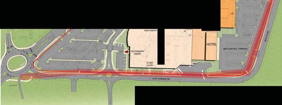
11 APPENDIX A QCCC Site Plan QCCC Monitoring and Treatment Plan


12
PLAN AND PROCEDURES FOR THE UNANTICIPATED DISCOVERY OF CULTURAL RESOURCES AND HUMAN SKELETAL REMAINS
 PLAN AND PROCEDURES FOR THE UNANTICIPATED DISCOVERY OF CULTURAL RESOURCES AND HUMAN SKELETAL REMAINS REGIONAL ON-SITE SEWAGE SYSTEM LOAN PROGRAM, WHATCOM COUNTY WASHINGTON 1. INTRODUCTION Whatcom County
The SMA and Archaeological/Cultural Resources
 The SMA and Archaeological/Cultural Resources Shoreline Coastal Planners Group October 20, 2016 Tim Gates Shoreline Policy Lead tim.gates@ecy.wa.gov (360) 407-6522 1 Acknowledges issues with laws and implementation
Unanticipated Discoveries Plan EXHIBIT J UNANTICIPATED DISCOVERIES PLAN FOR ARCHAEOLOGICAL PROPERTIES INCLUDING HUMAN REMAINS
 EXHIBIT J UNANTICIPATED DISCOVERIES PLAN FOR ARCHAEOLOGICAL PROPERTIES INCLUDING HUMAN REMAINS I. Introduction... 1 II. Definitions... 1 III. Personnel... 3 IV. Archaeological Resource Identification/Training...
ARCHAEOLOGICAL RESOURCES IN KING COUNTY
 DNRP/WTD ARCHAEOLOGICAL RESOURCES IN KING COUNTY Historic Preservation Program, Department of Natural Resources and Parks 201 S. Jackson St., Suite 700 [MS: KSC-NR-0700], Seattle, WA 98104 (206) 477-4529
Research Design for Archaeological Fieldwork Draft 1
 March 2013 FEDERAL WAY LINK EXTENSION Research Design for Archaeological Fieldwork Draft 1 This page intentionally left blank. Sound Transit Federal Way Link Extension Research Design for Archaeological
APPENDIX M PROGRAMMATIC AGREEMENT
 APPENDIX M PROGRAMMATIC AGREEMENT PROGRAMMATIC AGREEMENT AMONG THE FEDERAL HIGHWAY ADMINISTRATION, THE ARKANSAS STATE HIGHWAY AND TRANSPORTATION DEPARTMENT AND THE ARKANSAS STATE HISTORIC PRESERVATION
STATE ENVIRONMENTAL POLICY ACT MITIGATED DETERMINATION OF NONSIGNIFICANCE
 n+ Skamania County Community Development Department Building/Fire Marshal Environmental Health Planning Skamania County Courthouse Annex Post Office Box 1009 Stevenson, Washington 98648 Phone: 509-427-3900
TEL FAX
 20 EXECUTIVE PARK, SUITE 200 IRVINE, CALIFORNIA 92614 949.553.0666 TEL 949.553.8076 FAX BERKELEY CARLSBAD FORT COLLINS FRESNO PALM SPRINGS PT. RICHMOND RIVERSIDE ROCKLIN SAN LUIS OBISPO November 15, 2013
Appendix G Draft Memorandum of Agreement
 Appendix G Draft Memorandum of Agreement DRAFT MEMORANDUM OF AGREEMENT AMONG THE FEDERAL TRANSIT ADMINISTRATION, WASHINGTON STATE HISTORIC PRESERVATION OFFICER, AND THE CENTRAL PUGET SOUND REGIONAL TRANSIT
Archaeological Investigations Northwest, Inc.
 Archaeological Investigations Northwest, Inc. 3510 N.E. 122 nd Ave. Portland, Oregon 97230 Vancouver Phone (360) 696-7473 Phone (503) 761-6605 Fax (503) 761-6620 E-mail: ainw@ainw.com Web: www.ainw.com
Summary of Phase I Archaeological Survey for the NICTD Double Track NWI, Gary, IN, to Michigan City, IN
 Summary of Phase I Archaeological Survey for the NICTD Double Track NWI, Gary, IN, to Michigan City, IN INDOT Des. No. DHPA No. 19318 May 25, 2017 Summary of Phase I Archaeological Survey for the NICTD
Orange County Central Utility Facility Upgrade IP
 MITIGATION MONITORING AND REPORTING PROGRAM The California Public Resources Code, Section 21081.6, requires that a lead or responsible agency adopt a mitigation monitoring and reporting plan when approving
6. The following paragraphs provide further interim guidance where the ACHP regulations are not specific to the Corps Regulatory Program:
 ENCLOSURE Subject: Interim Guidance for Implementing Appendix C of 33 CFR part 325 with the revised Advisory Council on Historic Preservation Regulations at 36 CFR part 800 1. Consulting parties. Public
Chapter 16 Historic and Cultural Resources
 Chapter 16 Historic and Cultural Resources 1 What is the definition of historic, cultural, and archaeological resources? A historic or cultural resource is any site, building, structure, object, district,
Googong Township water cycle project: Stage A - Network (west)
") Googong Township water cycle project: Stage A - Network (west) Heritage management plan November 2012 MANIDIS ROBERTS PTY LTD ABN 42 003 550 972 Level 9, 17 York Street, Sydney NSW 2000 GPO Box 91, Sydney
Googong Township water cycle project: Stage A - Network (west) Heritage management plan November 2012 MANIDIS ROBERTS PTY LTD ABN 42 003 550 972 Level 9, 17 York Street, Sydney NSW 2000 GPO Box 91, Sydney
ATTACHMENT D -1 SUMMARY OF PHMC COORDINATION
 ATTACHMENT D -1 SUMMARY OF PHMC COORDINATION Revised November 18, 2016 Note: This Attachment has been replaced in its entirety Agency Consultation/Coordination: The results of the archaeological, geomorphological
4.4 Cultural Resources
 Introduction This chapter discusses the effects of the proposed project with respect to cultural resource impacts from the proposed land use activities. The major source used in this analysis is the recirculated
EVALUATION CHECKLIST FOR ARCHAEOLOGICAL PROPERTIES
 EVALUATION CHECKLIST FOR ARCHAEOLOGICAL PROPERTIES SIGNIFICANCE CRITERION D Define the relevant context and level of significance (local, state, or national). This may be done simultaneously with the next
Phase I/II Archaeological Survey
 DRAFT PROGRAMMATIC AGREEMENT AMONG THE CITY OF NEW ORLEANS, THE HOUSING AUTHORITY OF NEW ORLEANS, THE LOUISIANA STATE HISTORIC PRESERVATION OFFICER, AND THE ADVISORY COUNCIL ON HISTORIC PRESERVATION REGARDING
Memorandum. To: From: Date: July 25, 2018
 40600-HS-MEM-55030 Revision 0 Memorandum To: From: April Ryckman, Environmental Scientist BergerABAM 1301 Fifth Avenue, Suite 1200 Seattle, WA 98101-2677 Lauran R. Switzer, MA, RPA ICF Senior Archaeologist
5.3 CULTURAL RESOURCES
 5.3 CULTURAL RESOURCES 5.3.1 INTRODUCTION This section discusses the existing cultural resources on the project site and evaluates whether the proposed project will cause a substantial adverse change to
STATE ENVIRONMENTAL POLICY ACT MITIGATED DETERMINATION OF NONSIGNIFICANCE
 n+ Skamania County Community Development Department Building/Fire Marshal Environmental Health Planning Skamania County Courthouse Annex Post Office Box 1009 Stevenson, Washington 98648 Phone: 509-427-3900
ARCHAEOLOGICAL MONITORING PLAN:
 ARCHAEOLOGICAL MONITORING PLAN: MAGNOLIA PLACE PROJECT (APNS 032-311-120 AND 032-311-130) 106-110 & 120 TILTON AVENUE, SAN MATEO, CALIFORNIA Prepared for: Tim O Riordan O Riordan Construction 353 West
STATE ENVIRONMENTAL POLICY ACT MITIGATED DETERMINATION OF NONSIGNIFICANCE
 n+ Skamania County Community Development Department Building/Fire Marshal Environmental Health Planning Skamania County Courthouse Annex Post Office Box 1009 Stevenson, Washington 98648 Phone: 509-427-3900
ARCHAEOLOGICAL SURVEY OF THE COVEL GARDENS LANDFILL AREA IN SAN ANTONIO, BEXAR COUNTY, TEXAS. Daniel R. Potter
 ARCHAEOLOGICAL SURVEY OF THE COVEL GARDENS LANDFILL AREA IN SAN ANTONIO, BEXAR COUNTY, TEXAS Daniel R. Potter Center for Archaeological Research The University of Texas at San Antonio@ Archaeological Survey
Second Avenue Subway Draft Programmatic Agreement WHEREAS WHEREAS WHEREAS WHEREAS WHEREAS WHEREAS WHEREAS
 DRAFT PROGRAMMATIC AGREEMENT AMONG THE FEDERAL TRANSIT ADMINISTRATION, THE METROPOLITAN TRANSPORTATION AUTHORITY NEW YORK CITY TRANSIT, AND THE NEW YORK STATE HISTORIC PRESERVATION OFFICER REGARDING THE
Lauren Erickson, Hearing Examiner, City of Port Angeles. Allyson Brekke, AICP, Planning Manager, Community and Economic Development
 Phase 1 Terminal 7 Stormwater Improvements SMA No. 17-32 DATE: July 21, 2017 TO: FROM: Lauren Erickson, Hearing Examiner, City of Port Angeles Allyson Brekke, AICP, Planning Manager, Community and Economic
Chapter 5 Regulatory Coordination and Compliance
 Chapter 5 Regulatory Coordination and Compliance This chapter provides an update on the federal, state, and local laws and regulations that required the City to coordinate with regulatory agencies to obtain
RESOLUTION NO
 RESOLUTION NO. 1892-17 A RESOLUTION OF THE CITY COUNCIL OF THE CITY OF WESTLAKE VILLAGE ADOPTING A MITIGATED NEGATIVE DECLARATION, ADOPTING A MITIGATION MONITORING AND REPORTING PROGRAM, AND APPROVING
AN ARCHAEOLOGICAL SURVEY FOR THE BELL-MILAM-FALLS WATER SUPPLY CORPORATION USDA RURAL DEVELOPMENT PROJECT IN MILAM COUNTY, TEXAS
 AN ARCHAEOLOGICAL SURVEY FOR THE BELL-MILAM-FALLS WATER SUPPLY CORPORATION USDA RURAL DEVELOPMENT PROJECT IN MILAM COUNTY, TEXAS Antiquities Permit 5728 By William E. Moore Brazos Valley Research Associates
ARCHAEOLOGICAL REQUIREMENTS OVERVIEW
 ARCHAEOLOGICAL REQUIREMENTS OVERVIEW The protection of New Jersey s archaeological heritage is an important part of New Jersey Historic Trust programs. All grants must address potential impacts to archaeological
I. GENERAL INFORMATION
 STAFF REPORT ST. JEAN MOORING BUOY &ACCESS CUTBACK TO: Douglas County Hearing Examiner FROM: Douglas County Land Services Staff RE:, SP-13-10 DATE: January 6,2014 I. GENERAL INFORMATION Requested Action:
New Jersey Pennsylvania Lackawanna Cut-Off Passenger Rail Service Restoration Environmental Assessment. Appendix B
 New Jersey Pennsylvania Lackawanna Cut-Off Passenger Rail Service Restoration Environmental Assessment Appendix B Programmatic Agreement Among The Federal Transit Administration (FTA), The Pennsylvania
Appendix G: Mitigation Monitoring and Reporting Program
 : Proposed Scotts Valley Multi-Agency Regional Intertie Project The following (MMRP) has been prepared for the Scotts Valley Multi-Agency Regional Intertie Project. The MMRP identifies project impact mitigation
Mary Morse Shaw TR et el. (PLN020567
 MIKE NOVO ZONING ADMINISTRATOR STATE OF CALIFORNIA COUNTY OF MONTEREY RESOLUTION NO. 020567 A.P. # 189-011-023-000 In the matter of the application of Mary Morse Shaw TR et el. (PLN020567 FINDINGS & DECISION
VALLEY LATERAL PROJECT. RESOURCE REPORT 4 Cultural Resources. FERC Docket No. CP
 VALLEY LATERAL PROJECT RESOURCE REPORT 4 Cultural Resources FERC Docket No. CP16- -000 November 2015 Section TABLE OF CONTENTS Page 4.0 CULTURAL RESOURCES... 4-1 REGULATORY OVERVIEW... 4-1 AREA OF POTENTIAL
WHEREAS, the Boston Landmarks Commission (BLC) has participated in the consultation and has been invited to concur in the Agreement; and
 has participated in the consultation and has been invited to concur in the Agreement; and") MEMORANDUM OF AGREEMENT BY AND AMONG THE FEDERAL TRANSIT ADMINISTRATION, THE MASSACHUSETTS STATE HISTORIC PRESERVATION OFFICER, AND THE MASSACHUSETTS BAY TRANSPORTATION AUTHORITY SUBMITTED TO THE ADVISORY
MEMORANDUM OF AGREEMENT BY AND AMONG THE FEDERAL TRANSIT ADMINISTRATION, THE MASSACHUSETTS STATE HISTORIC PRESERVATION OFFICER, AND THE MASSACHUSETTS BAY TRANSPORTATION AUTHORITY SUBMITTED TO THE ADVISORY
MMRP for Metro Red/Purple Line Core Capacity Improvements Project
 MMRP for This (MMRP) contains mitigation measures for the Red/Purple Line Core Capacity Improvements Project, which will be approved by the Los Angeles County politan Transportation Authority () Board
The source of information used in this report is based on the database of published and unpublished information which is available for the area.
 15 HERITAGE ASSESSMENT 15.1 Introduction ACO Associates cc was requested to undertake a Heritage Impact Assessment (HIA) consisting of an Archaeological study, Paleontological study and Visual Study in
Enacted in 1970 by the California legislature, the
 293 Pipelines to Our Past Myra Herrmann In order to reduce impacts to potentially significant or unknown historical resources, construction monitoring for public and private development projects is required.
ARCHAEOLOGICAL REQUIREMENTS
 ARCHAEOLOGICAL REQUIREMENTS The protection of New Jersey s archaeological heritage is an important part of New Jersey Historic Trust programs. All grants must address potential impacts to archaeological
Appendix B Section 106 Memorandum of Agreement
 VIRGINIA AVENUE TUNNEL RECONSTRUCTION PROJECT NATIONAL ENVIRONMENTAL POLICY ACT RECORD OF DECISION Appendix B Section 106 Memorandum of Agreement THIS PAGE INTENTIONALLY LEFT BLANK. MEMORANDUM OF AGREEMENT
This is a digital document from the collections of the Wyoming Water Resources Data System (WRDS) Library.
 Library.") This is a digital document from the collections of the Wyoming Water Resources Data System (WRDS) Library. For additional information about this document and the document conversion process, please contact
This is a digital document from the collections of the Wyoming Water Resources Data System (WRDS) Library. For additional information about this document and the document conversion process, please contact
ARCHAEOLOGICAL ASSESSMENT TECHNICAL GUIDELINES
 ARCHAEOLOGICAL ASSESSMENT TECHNICAL GUIDELINES i CULTURAL HERITAGE RESOURCE CONSERVATION IN THE ONTARIO LAND USE PLANNING PROCESS ARCHAEOLOGICAL ASSESSMENT TECHNICAL GUIDELINES 1993 (Stages 1-3 & Reporting
DECISION MEMO OREGON DEPARTMENT OF TRANSPORTATION (ODOT) SAND SHED CINDER PIT EXPLORATION PROJECT
 SAND SHED CINDER PIT EXPLORATION PROJECT") DECISION MEMO OREGON DEPARTMENT OF TRANSPORTATION (ODOT) SAND SHED CINDER PIT EXPLORATION PROJECT USDA Forest Service Bend/Fort Rock Ranger District, Deschutes National Forest Deschutes County, Oregon
DECISION MEMO OREGON DEPARTMENT OF TRANSPORTATION (ODOT) SAND SHED CINDER PIT EXPLORATION PROJECT USDA Forest Service Bend/Fort Rock Ranger District, Deschutes National Forest Deschutes County, Oregon
Memo. To: Annette Nesse, Chief Operations Officer. From: Subject: Leanne Jenkins, Planning Director TEPA , Sophus-Corriea Loop Road
 Memo To: Annette Nesse, Chief Operations Officer From: Subject: Leanne Jenkins, Planning Director TEPA 2017-02, Date: Thank you for the opportunity to review the details of this project. Attached you will
MITIGATION MEASURES TO BE INCLUDED IN THE PROJECT AND AGREED TO BY THE PROJECT SPONSOR AND ALL SUBSEQUENT PROPERTY OWNERS AND PERMITEES FOR THE
 MITIGATION MEASURES TO BE INCLUDED IN THE PROJECT AND AGREED TO BY THE PROJECT SPONSOR AND ALL SUBSEQUENT PROPERTY OWNERS AND PERMITEES FOR THE TIBURCIO VASQUEZ HEALTH CENTER ALAMEDA COUNTY, CALIFORNIA
NISQUALLY RED WIND CASINO REQUEST FOR QUALIFICATIONS / PROPOSAL FOR MASTER PLANNING SERVICES
 NISQUALLY RED WIND CASINO REQUEST FOR QUALIFICATIONS / PROPOSAL FOR MASTER PLANNING SERVICES Proposal Due Date: February 7, 2018 at 1:00 PM PST RED WIND CASINO HOTEL DEVELOPMENT RFQ/P 1 January 23, 2018
STAFF REPORT TOMMER SHORT TERM MINERAL EXTRACTION
 STAFF REPORT TOMMER SHORT TERM MINERAL EXTRACTION TO: Douglas County Hearing Examiner FROM: Douglas County Land Services Staff RE: Tommer, CUP-2017-05 DATE: August 16, 2018 I. GENERAL INFORMATION Requested
MONTEREY COUNTY PLANNING & BUILDING INSPECTION DEPARTMENT st AVENUE MARINA, CA (831) FAX: (831)
 FAX: (831)") MONTEREY COUNTY PLANNING & BUILDING INSPECTION DEPARTMENT 2620 1st AVENUE MARINA, CA 93933 (831) 883-7500 FAX: (831)384-3261 MONTEREY COUNTY ZONING ADMINISTRATOR Meeting: June 12, 2003 at 10:00 a.m. Agenda
MONTEREY COUNTY PLANNING & BUILDING INSPECTION DEPARTMENT 2620 1st AVENUE MARINA, CA 93933 (831) 883-7500 FAX: (831)384-3261 MONTEREY COUNTY ZONING ADMINISTRATOR Meeting: June 12, 2003 at 10:00 a.m. Agenda
MITIGATION MONITORING & REPORTING PLAN
 MITIGATION MONITORING & REPORTING PLAN The following environmental mitigation measures shall be incorporated into the project development as Conditions of Approval (MND 2329). The project applicant shall
4.11 CULTURAL RESOURCES
 4.11 CULTURAL RESOURCES 4.11.1 Impact Methodology The methods for assessing potential impacts on cultural resources include identifying significant cultural resources in the areas of potential effect (APEs)
STAFF REPORT. Planning Commission. Anjanette Simon, Associate Planner
 STAFF REPORT TO: Planning Commission HEARING DATE: May 23, 2012 FROM: APPLICATIONS: LOCATION: Anjanette Simon, Associate Planner ZMA2012-0005 (158th and Baseline Station Community High Density Residential
The current note, approved by the County Commission on August 11, 2015 (INSTR # ) reads as follows:
 reads as follows:") Page 1 of 16 STAFF REPORT Palm Aire Cypress Course Estates 4 th Section 126-MP-81 A request to amend the note on the plat has been filed with the Planning and Development Management Division. This plat
Page 1 of 16 STAFF REPORT Palm Aire Cypress Course Estates 4 th Section 126-MP-81 A request to amend the note on the plat has been filed with the Planning and Development Management Division. This plat
RESOLUTION NO Adopted by the Sacramento City Council. July 14, 2015
 RESOLUTION NO. 2015-0219 Adopted by the City Council July 14, 2015 APPROVING THE PRELIMINARY PLANS AND ADOPTING THE MITIGATED NEGATIVE DECLARATION AND THE FOR THE VINCI AVENUE BRIDGE REPLACEMENT PROJECT
ANTIQUITIES PERMIT APPLICATION FORM ARCHEOLOGY
 ANTIQUITIES PERMIT APPLICATION FORM ARCHEOLOGY GENERAL INFORMATION I. PROPERTY TYPE AND LOCATION Project Name (and/or Site Trinomial) East Williamson County Events Center Access Road County (ies) Williamson
California Environmental Quality Act Part 1: CEQA Basics
 California Environmental Quality Act Part 1: CEQA Basics California Preservation Foundation Webinar June 10, 2014 Presented by Chris McMorris Partner / Architectural Historian Overview of CEQA California
FEDERAL REGULATIONS AND THE DEPARTMENT OF THE NAVY S CULTURAL RESOURCE RESPONSIBILITIES
 FEDERAL REGULATIONS AND THE DEPARTMENT OF THE NAVY S CULTURAL RESOURCE RESPONSIBILITIES Since the 1960s, Congress has passed a series of laws that protect cultural resources and require all federal agencies
FEDERAL HIGHWAY ADMINISTRATION RECORD OF DECISION FOR THE LYNNWOOD LINK EXTENSION
 FEDERAL HIGHWAY ADMINISTRATION RECORD OF DECISION FOR THE LYNNWOOD LINK EXTENSION AUGUST 2015 Table of Contents 1 Decision... 1 1.1 Project Description... 2 1.2 Basis for the FHWA Decision... 7 1.2.1
Appendix K Section 106 of the National Historic Preservation Act, Programmatic Agreement Regarding the Sterling Highway Milepost 45 to 60 Project
 Appendix K Section 106 of the National Historic Preservation Act, Programmatic Agreement Regarding the Sterling Highway Milepost 45 to 60 Project Federal Highway Administration Alaska Division P.O. Box
Article 7. COMMERCIAL AND MIXED USE ZONES
 COMMERCIAL AND MIXED USE ZONES 24-21 Article 7. COMMERCIAL AND MIXED USE ZONES Sections: 24-21 Purpose of the Commercial and Mixed Use s 24-22 Land Use Regulations for Commercial and Mixed Use s 24-23
Preliminary Decision Memo 2015 Recreation Residence Projects Odell Lake
 2015 Recreation Residence Projects Odell Lake USDA Forest Service Crescent Ranger District, Deschutes National Forest Klamath County, Oregon Background The Crescent Ranger District maintains 66 recreation
Phase I Archaeological Survey of the Lawrence University Garden, Appleton, Wisconsin
 Lawrence University Lux Archaeological Reports Anthropology Department 10-2-2009 Phase I Archaeological Survey of the Lawrence University Garden, Appleton, Wisconsin Lawrence University Follow this and
JOINT PUBLIC NOTICE. March 19, Leake Avenue Post Office Box 4313 New Orleans, Louisiana Baton Rouge, Louisiana
 JOINT PUBLIC NOTICE March 19, 2018 United States Army Corps of Engineers State of Louisiana New Orleans District Department of Environmental Quality Regulatory Branch Water Permits Division 7400 Leake
NOTICE OF PREPARATION
 NOTICE OF PREPARATION DATE: April 6, 2017 TO: FROM: SUBJECT: Responsible Agencies, Trustee Agencies, and Interested Persons Timbisha Shoshone Tribe Attn: NOP Comments P.O. Box 1779 Bishop, CA 93515 Fax:
Stafford Fire Salvage and Restoration Project Heritage Report. South Fork Management Unit Shasta-Trinity National Forest
 Stafford Fire Salvage and Restoration Project Heritage Report South Fork Management Unit Shasta-Trinity National Forest Legal Location: The project area is located within the South Fork Management Unit
STAFF REPORT WASHINGTON STATE PARKS AND RECREATION COMMISSION COVERED SHELTERS AND BIKE RACKS
 STAFF REPORT WASHINGTON STATE PARKS AND RECREATION COMMISSION COVERED SHELTERS AND BIKE RACKS TO: Douglas County Hearing Examiner FROM: Douglas County Land Services Staff RE: SP-2019-02 DATE: April 8,
Snohomish County Council
 Snohomish County Council Committee: Planning & Community Development Analyst: Yorik Stevens-Wajda ECAF: 8361 (proposed motion 17-117) Date: June 11, 2017 Motion 17-117 would provide direction on which,
CEQA and its Role in Historic Preservation. Darcy Kremin, AICP Bay Area Environmental Practice Leader Michael Baker International, Oakland, CA
 CEQA and its Role in Historic Preservation Darcy Kremin, AICP Bay Area Environmental Practice Leader Michael Baker International, Oakland, CA General CEQA Requirements and Limitations Mitigation Measures
CEMVR-OD-P WETLAND COMPENSATORY MITIGATION BANK PROPOSAL
 This purpose of this public notice is to solicit comments on the proposed project. POC: Trevor Popkin, Telephone: 309/794-5329 r:'l"r.'i ~ PUBLIC NOTICE US Army Corps of Engineers Rock Island District
Decision Memo. Administrative Site Disposal Old Agness Guard Station Compound
 Decision Memo Administrative Site Disposal Old Agness Guard Station Compound US Forest Service Pacific Northwest Region Rogue River-Siskiyou National Forest Legal Location: SW ¼ Section 7, T. 35 S., R.
NOTICE OF ADOPTION OF OFFICIAL PLAN AMENDMENT NO. 6 TO THE YORK REGION OFFICIAL PLAN
 Subject: Amendment No. 6 to the York Region Official Plan, 2010 File No.: 190P-2010-006 Date of this notice: February 26, 2014 Last date of appeal: March 18, 2014 NOTICE OF ADOPTION OF OFFICIAL PLAN AMENDMENT
AVOIDANCE & MINIMIZATION MEASURES: NO ADVERSE EFFECT
 CHAPTER 9: AVOIDANCE & MINIMIZATION MEASURES: NO ADVERSE EFFECT The outcome of the Section 106 process is not predetermined. As such, alternative, non-standard approaches can typically come out of the
Re: Dawson Geophysical Company s Proposed San Rafael Saddle 3-D Geophysical Exploration Project, Emery County, Utah.
 12 December 2006 Price Field Office Bureau of Land Management Attn: Don Stephens 125 South 600 West Price, Utah 84501 Re: Dawson Geophysical Company s Proposed San Rafael Saddle 3-D Geophysical Exploration
DRAFT. WHEREAS, FHWA, USMC, NPS, DDOT, DPR, DCSHPO and CSX are hereafter referred to as the Signatories to this MOA; and
 MEMORANDUM OF AGREEMENT AMONG THE FEDERAL HIGHWAY ADMINISTRATION THE UNITED STATES MARINE CORPS THE NATIONAL PARK SERVICE THE DISTRICT DEPARTMENT OF TRANSPORTATION THE DISTRICT DEPARTMENT OF PARKS AND
ANALYSIS MAJOR USE SPECIAL PERMIT for Brickell Flatiron located at approximately 1001, 1015, 1023, 1101 and 1121 South Miami Avenue
 ANALYSIS MAJOR USE SPECIAL PERMIT for Brickell Flatiron located at approximately 1001, 1015, 1023, 1101 and 1121 South Miami Avenue LEGISTAR FILE ID: Pursuant to Ordinance 11000, as amended, the Zoning
Code of Conduct for the Treatment of Human Remains
 Code of Conduct for the Treatment of Human Remains in the context of an archaeological excavation First edition May 2006 Contents 1. OBJECTIVES... 1 2. SCOPE OF WORKS... 1 The Code of Professional Conduct
MITIGATION MONITORING & REPORTING PLAN
 The following environmental mitigation measures shall be incorporated into the project development as Conditions of Approval (MND 2340). The Project Applicant shall secure a signed verification for the
Archaeological Monitoring along the STH 57 Project Corridor, WisDOT Project Numbers /
 H R M S HISTORIC RESOURCE MANAGEMENT SERVICES A Contractual Program of the Department of Anthropology at the University of Wisconsin-Milwaukee helping to insure the future of the past Archaeological Monitoring
Monitoring Report No. 45
 Enniskillen Castle Barracks Enniskillen Co. Fermanagh AE/05/112 Dr Colm Donnelly Site Specific Information Site Address: Enniskillen Castle Barracks, Enniskillen, Co. Fermanagh Town: Enniskillen SMR No.:
Grading & Excavation Information Application & Checklist
 Grading & Excavation Information Application & Checklist Yakima County Public Services ~ Building & Fire Safety Division 128 North 2 nd Street, Yakima, WA 98901 ~ Office (509) 574-2300 Building & Fire
PROSPECTUS CAPPELL C LOGGING UNIT YUROK INDIAN LANDS
 PROSPECTUS CAPPELL C LOGGING UNIT YUROK INDIAN LANDS I. INTRODUCTION The purpose of this Prospectus is to furnish sufficient information in addition to that contained in the published advertisement to
BEFORE THE DIRECTOR CITY OF TACOMA
 1 2 BEFORE THE DIRECTOR CITY OF TACOMA 3 4 5 6 7 8 9 10 In the Matter of: Shoreline Development Application File Number SHR2015-40000246123 Larry Tornberg, Puget Sound Energy, and Tony Warfield, Port of
Environmental Assessment House, West Malheur and Wolf Mountain Allotments Heritage 201
 Environmental Assessment House, West Malheur and Wolf Mountain Allotments Heritage The National Historic Preservation Act (NHPA) of 1966, as amended through 2000, states in Section 110, 2b: that such properties
Tree Protection Policy
 Appendix F Tree Protection Policy The following is according to the City of Hamilton s special provision SP-97. General Tree Protection shall be in accordance with OPSS 801 as amended by this special provision.
5 OTHER CEQA SECTIONS
 5 OTHER CEQA SECTIONS This chapter summarizes the environmental impacts of the proposed project for which no mitigation is available to reduce the level of significance to a less-than-significant level,
STATE OF OREGON CULTURAL RESOURCES SURVEY COVER
 STATE OF OREGON CULTURAL RESOURCES SURVEY COVER (Updated 6/10/2013) Please submit reports unbound. Author(s) Name: Blake, Karry Title of Report: Results of Cultural Resources Monitoring for the Sadri-East
STAFF REPORT F.P. & L. Welleby Substation 059-MP-83
 Page 1 of 11 STAFF REPORT F.P. & L. Welleby Substation 059-MP-83 A request to amend the note on the plat has been filed with the Planning and Development Management Division. The plat was approved by the
Carpinteria Valley Water District Carpinteria Advanced Purification Project
 NOTICE OF PREPARATION AND SCOPING MEETING Carpinteria Valley Water District Carpinteria Advanced Purification Project TO: Agencies, Organizations, and Interested Parties DATE: January 7, 2019 SUBJECT:
SPECIAL PROVISIONS WATERWAY PERMITS CONDITIONS PID: Date: 3/8/18 C-R-S: UNI-TR
 SPECIAL PROVISIONS WATERWAY PERMITS CONDITIONS C-R-S: UNI-TR 0308-00.57 PID: 99910 Date: 3/8/18 Special Provisions: UNI-TR 0308-00.57, PID 99910 Page 2 of 7 1. Waterway Permits Time Restrictions: USACE
SECTION EARTHWORK; EXCAVATION, FILLING AND GRADING. A. Excavating soil and other material for surface improvements.
 SECTION 31 20 00 PART 1 - GENERAL 1.1 SECTION INCLUDES A. Excavating soil and other material for surface improvements. B. Excavating soil and other material for drainage basins. C. Placing fill. D. Compaction
Remediation Plan. for. Creek County Landfill Site. E/2 SE NW 28-18N-12E Creek County, OK
 Remediation Plan for Creek County Landfill Site in E/2 SE NW 28-18N-12E Creek County, OK Draft Remediation Plan Table of Contents 1.0 GENERAL... 3 1.1 Location... 3 1.2 Site Boundaries... 3 1.3 Background...
Preliminary Decision Memo 2017 BPA Utility Corridor Maintenance and Danger Tree Project
 Preliminary Decision Memo 2017 BPA Utility Corridor Maintenance and Danger Tree Project USDA Forest Service Crescent Ranger District, Deschutes National Forest Klamath County, Oregon The Crescent Ranger
Proposed Boykins Substation Microwave Tower May 31, 2017
 Proposed Boykins Substation Microwave Tower May 31, 2017 Summary: Dominion Virginia Energy is seeking approval for a Conditional Use Permit and a setback variance to install a wireless communication tower
WHATCOM COUNTY PLANNING & DEVELOPMENT SERVICES STAFF REPORT
 Pipeline Safety & Development Changes Staff Report, Page 1 WHATCOM COUNTY PLANNING & DEVELOPMENT SERVICES STAFF REPORT I. SUMMARY OF PROPOSAL AND RECOMMENDATION File # ZON2007-00014 File Name: Pipeline
ABEL UNDERGROUND MINE: ABORIGINAL HERITAGE MANAGEMENT PLAN
 ABEL UNDERGROUND MINE: ABORIGINAL HERITAGE MANAGEMENT PLAN FINAL VERSION 1.0 DONALDSON COAL Pty Limited PO Box 2275 Greenhills NSW 2323 16 November 2007 TABLE OF CONTENTS 1 INTRODUCTION... 2 2 ABORIGINAL
IRVINE UNIFIED SCHOOL DISTRICT MITIGATION MONITORING AND REPORTING PROGRAM FOR THE PLANNING AREA 6 NORTH ELEMENTARY SCHOOL
 IRVINE UNIFIED SCHOOL DISTRICT MITIGATION MONITORING AND REPORTING PROGRAM FOR THE PLANNING AREA 6 NORTH ELEMENTARY SCHOOL Prepared for: IRVINE UNIFIED SCHOOL DISTRICT Facilities Planning & Construction
Appendix A: Mitigation Monitoring and Reporting Plan
 of Response to Comments Appendix A: Mitigation Monitoring and Reporting Plan 295 S:\Luke\Projects\2749 of \0003 Telecom Towers\FEIR\FEIR\PSEC Final EIR and RTC's.doc of AIR QUALITY MEASURES MM AQ-1 All
September 12, Ms. Lisa Plowman Planning Manager RRM Design 10 East Figueroa Street, Suite 1. Santa Barbara, CA 93101
 APPENDIX A Addendum to Reconnaissance Level Historic Resources Survey Letter Report Preliminary Impacts Analysis - Lone Star (CEMEX) Restoration/Reuse Project in Davenport, California, Wood, September
Decision Memo for Juniper Ridge Opal Mine
 for USDA Forest Service Pacific Northwest Region Fremont-Winema National Forests Bly Ranger District Klamath County, Oregon Introduction The Bly Ranger District has received a proposed operating plan for