Kevin L. Erwin CE PWS Kevin L. Erwin Consulting Ecologist, Inc Bayside Parkway Ft. Myers, Florida USA
|
|
|
- Theodore Chambers
- 6 years ago
- Views:
Transcription
1 Kevin L. Erwin CE PWS Kevin L. Erwin Consulting Ecologist, Inc Bayside Parkway Ft. Myers, Florida USA
2 The Lee County DR/GR: Implications for future restoration and management Estero Bay Watershed Public Symposium Florida Gulf Coast University September 2009
3 There is great potential for restoring and sustainably managing wetland and water resources combining wetland management, sustainable agriculture and phased wetland restoration in the midst of a changing global climate.
4 Recommendations Prepare a hydrological model of the study area which includes estimated watershed boundaries. Implement a comprehensive long-term surface and groundwater monitoring network that includes; shallow wells, deep wells, staff, flow and rain gauges. Develop and refine water budgets for each watershed in the DR/GR and conduct a comparative analysis with the estimated historical conditions. Develop detailed restoration plans for each watershed. Initiate discussions with agricultural interests on sustainable agriculture, habitat management and restoration objectives.
5 Recommendations Conduct limited ground-truthing to improve the accuracy of the existing conditions desktop mapping. Obtain accurate topography for the study area. Maintain and improve existing policy regulations requiring site and project specific hydrological data collection and analysis, including surface and groundwater monitoring, water budget, and water quality monitoring. Develop a working agreement with Collier County on land and water resource management on lands within watersheds shared by Collier and Lee Counties.

6 Why is the DR/GR important to Estero Bay?
7 Questions 1. What was the DR/GR like prior to recent alterations? What types of habitats had been predominant and what were the surface hydrologic characteristics (hydropatterns)? 2. What is the nature and extent of existing land uses, habitat types, location and conditions of remaining wetlands (hydropatterns), agricultural lands, and watersheds? 3. How wet was the DR/GR then and now and what is the extent of wetland loss?
8 Questions 4. What proportion of converted wetlands remains in agricultural use? 5. What are the similarities between wetlands and agricultural lands in the DR/GR? 6. What is the potential for restoring and sustainably managing these resources?

9 DR/GR Study Area Existing Conditions
10

11 DR/GR Study Area Current Hydropatterns
12 DR/GR Study Area Major Land Use Categories Existing Conditions LEVEL I FLUCFCS CATEGORY Urban and Built-up CORKSCREW ESTERO RIVER FLINT PEN IMPERIAL RIVER SIX MILE CYPRESS TOTAL 1, , , , Agriculture 11, , , , Rangeland Upland Forests , , , Water Wetlands 6, , , , , , Barren Land , Transportation, Communication, and Utilities GRAND TOTAL 20, , , , , ,878.7
13 Summary of the Correlation Between Various Land Use Coding Systems and the Hydropatterns in the DR/GR KLECE Codes (1953) MIKE SHE Codes FLUCFCS Codes (2007) Depth Hydroperiod Map Index Color 1, 1M, 1P, 2D 17, , Mos Dark Blue 2S , 617, Mos Medium Blue 3 14, , 630, 631, 643, 624, Mos Medium Light Blue 4 10, Mos Light Blue

14 DR/GR Study Area Historical Hydropatterns
15 Estimated Acreages of Major Wetland Habitats within the DR/GR in 1953 and Loss (in acres) Habitat Type Acreage FLUCFCS Code Acreage Marsh, Ponds, Deep Swamp 36,258.1 Shallow Cypress 10, , 617, 619, 621, , 628, 630, 631 Hydric Pine 24, , , ,981.1 (21,277)/58.7% 16, /53% (12,812.5)/53.1 % Total 70, , ,427.8/40%
16
17
18 DR/GR Study Area Historical Wetlands Converted to Agriculture
19 Historic water level Drained wetland in eastern Ontario

20 Restoring wetlands in Florida +50 years after conversion to Agriculture

21

22

23

24

25 DR/GR Study Area Historical Wetlands Converted to Agriculture
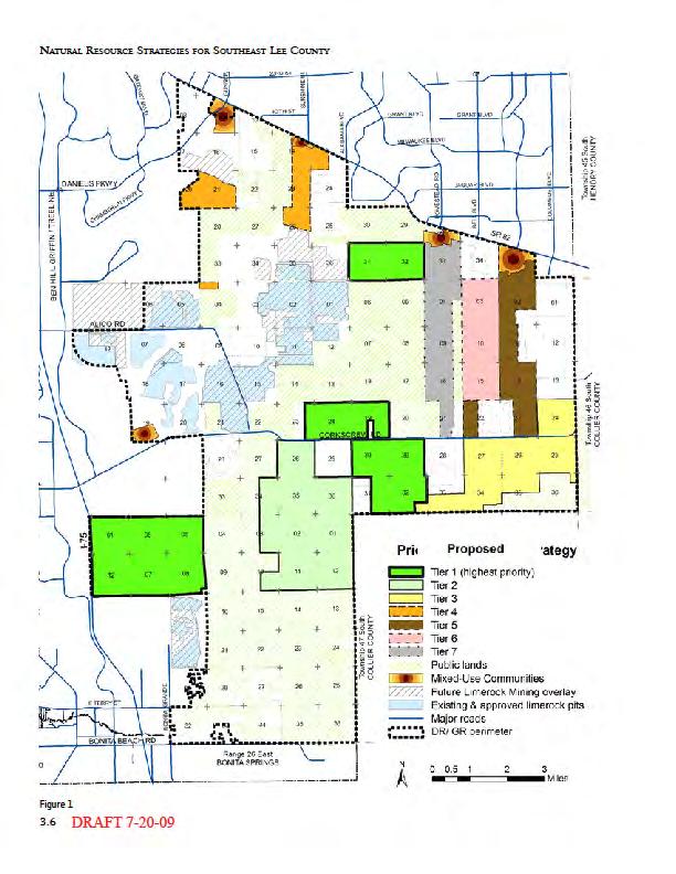
26 DR/GR Study Area Priority I, II, and III Restoration Plan

27 Restoration Recommendation and the Historical Hydropatterns
28
29 Loss (in acres) Habitat Type Acreage FLUCFCS Code Acreage 1M, 1P, 2D, 2S 36, , 617, 619, 621, ,981.1 (21,277)/58.7% 3 10, , 628, 630, , /53% 4 24, , ,300.4 (12,812.5)/53.1% Total 70, , ,427.8/40% LEVEL I FLUCFCS CATEGORY CORKSCREW ESTERO RIVER FLINT PEN IMPERIAL RIVER SIX MILE CYPRESS 200 Agriculture 11, , , , Rangeland Upland Forests , , , Water Wetlands 6, , , , , ,541.6 GRAND TOTAL 20, , , , , ,878.7 TOTAL
30
31
32

33
34
35
36

37
38
CenterPlace. SW Florida International Airport Cemex Mine. Meridian Center IHub. Gulf Coast Town Center. Miromar Lakes. Youngquist Mine FGCU
 SW Florida International Airport Cemex Mine Meridian Center IHub Gulf Coast Town Center CenterPlace Miromar Lakes FGCU Youngquist Mine University Highlands Grandezza Corkscrew Woods Preserve at Corkscrew
Natural Resource Value of Edison Farms/Agripartners. Presented by: Jessica Stubbs, Natural Resources Specialist
 Natural Resource Value of Edison Farms/Agripartners Through Research and Science Presented by: Jessica Stubbs, Natural Resources Specialist Introduction to Edison Farms Almost 4,000 acres Within Estero
CONSERVATION 20/20 OVERVIEW. Cathy Olson, Conservation Lands Manager Lee County Department of Parks and Recreation
 CONSERVATION 20/20 OVERVIEW Cathy Olson, Conservation Lands Manager Lee County Department of Parks and Recreation What is Conservation 20/20? Lee County s current environmentally sensitive land acquisition
Recent hydrologic change in a rainfalldriven. Everglades swamp. Shawn E. Clem. Michael J. Duever Natural Ecosystems
 Recent hydrologic change in a rainfalldriven Western Everglades swamp Shawn E. Clem Western Everglades Research Center Corkscrew Swamp Sanctuary sclem@audubon.org Shawn E. Clem Michael J. Duever Natural
Charlotte Harbor SWIM Plan Update Proposed Quantifiable Objectives and Management Actions, January 2019
 Management Actions One of the goals of this SWIM plan is to identify strategic initiatives that will address the major issues and drivers and provide management actions that will improve and maintain the
How to avoid getting bogged down by the Nova Scotia Wetland Conservation Policy
 How to avoid getting bogged down by the Nova Scotia Wetland Conservation Policy for the Environmental Services Association of Nova Scotia By Krista Hilchey Wetland Specialist, Nova Scotia Environment To
Appendix I. Potential Adverse Change to Wetland Function Methodology and Results
 Appendix I Potential Adverse Change to Wetland Function Methodology and Results Technical Memorandum North Florida Regional Water Supply Plan Potential Adverse Change to Wetland Function January 3, 2017
Collaborative Opportunities to Restore Wetland Functions in an Urbanized Setting: Moses Creek Restoration Case Study
 Collaborative Opportunities to Restore Wetland Functions in an Urbanized Setting: Moses Creek Restoration Case Study Presented to: SER 2013 World Conference Madison, WI 2013 Award Winner Presented by:
Estero Bay Watershed Assessment
 Estero Bay Watershed Assessment Volume D: - Draft Report - Prepared for: South Florida Water Management District P.O. Box 24680 3301 Gun Club Road West Palm Beach, Florida 33416-4680 Prepared by: PBS&J,
Town of Sandown Wetland Evaluation Report
 Town of Sandown Wetland Evaluation Report Prepared for: Town of Sandown, NH Conservation Commission August 2008 Prepared by: 122 Mast Road, Suite 6, Lee, NH 03861 with assistance from TABLE OF CONTENTS
Wetland Functions in the Watershed: Part 1 Watershed Elements. USDA NRCS Module Name 1
 Wetland Functions in the Watershed: Part 1 Watershed Elements USDA NRCS Module Name 1 Objectives Define Landscape Elements in the Watershed Describe Hydrologic Connections Between Elements Introduce Soil
Mapping and Understanding YOUR LAKE S WATERSHED By: Tony Groves, Pam Tyning, and Tory Meyers Water Resources Group, Progressive AE
 By: Tony roves, Pam Tyning, and Tory Meyers Water Resources roup, Progressive A What is a Watershed? A watershed is the land area surrounding a lake from which water drains to the lake. The imaginary line
Progress on South Florida Estuaries Restoration: C-111 Western Spreader Canal and Biscayne Bay Coastal Wetland CERP Project
 Progress on South Florida Estuaries Restoration: C-111 Western Spreader Canal and Biscayne Bay Coastal Wetland CERP Project American Water Resources Association 2016 ANNUAL WATER RESOURCES CONFERECNCE
CPA CORKSCREW WOODS PRIVATELY SPONSORED AMENDMENT TO THE LEE COUNTY COMPREHENSIVE PLAN THE LEE PLAN
 CPA2011-18 CORKSCREW WOODS PRIVATELY SPONSORED AMENDMENT TO THE LEE COUNTY COMPREHENSIVE PLAN THE LEE PLAN LPA Public Hearing Document For the April 23 rd, 2012 Public Hearing Lee County Planning Division
THE NEW WETLAND RULES How do they affect you? City Engineers Conference January 27, 2010
 THE NEW WETLAND RULES How do they affect you? City Engineers Conference January 27, 2010 Introduction Beth Kunkel, PWS Certified Professional Wetland Scientist Certified Wetland Delineator 22 years working
MN CREP CP23 and CP23A
 MN CREP CP23 and CP23A Environmental Benefits Scoring Sheet Instructions 4/14/17 Scoring is a primary means of comparing the environmental benefits of each submitted application for MN CREP. To properly
Water Quality Buffers for Waters and Wetlands
 Water Quality Buffers for Waters and Wetlands 2008 Nor easter: Indian River Bay Progress Towards Pollution Reduction Goals for the Inland Bays Phosphorus (lbs. per day) Nitrogen (lbs. per day) 1,471
EXHIBIT A. FY Management Accomplishment Summary for Okaloacoochee Slough State Forest
 EXHIBIT A 2001-2011 Management Accomplishment Summary for Okaloacoochee Slough State Forest PROGRAM ACTIVITY 01/02 02/03 03/04 04/05 05/06 06/07 07/08 08/09 09/10 10/11 11/12 TOTAL Reforestation/ Restoration
Watershed Systems & Impairments
 Watershed Systems & Impairments Environmental Stewards Program ~ 2014 Lisa Galloway Evrard Senior Program Coordinator Rutgers Cooperative Extension Water Resources Program Part I: Overview of Watershed
Lee County Artesian Well Abandonment Project
 Lee County Artesian Well Abandonment Project Background Uncontrolled, improperly constructed, deteriorated or abandoned artesian (free-flowing) wells can have an adverse impact on the quantity and quality
2015 Reinvest in Minnesota (RIM) Reserve Wetlands Program
 Reserve Wetlands Program") 2015 Reinvest in Minnesota (RIM) Reserve Wetlands Program Site Evaluation Form Instructions Document 12/31/14 This instructions document is to be used for guidance in completing the Site Evaluation Form
2015 Reinvest in Minnesota (RIM) Reserve Wetlands Program Site Evaluation Form Instructions Document 12/31/14 This instructions document is to be used for guidance in completing the Site Evaluation Form
SW-74 SERENOVA PRESERVE SITES 2, 3, 4, 8 MITIGATION PLAN
 SW-74 SERENOVA PRESERVE SITES 2, 3, 4, 8 MITIGATION PLAN BACKGROUND INFORMATION Project SWIM? Aquatic Control? Exotic Control? Mitigation Bank? Type No No No No Mitigation Restoration and enhancement Type
Town of Fremont Wetland Evaluation Report
 University of New Hampshire University of New Hampshire Scholars' Repository PREP Reports & Publications Institute for the Study of Earth, Oceans, and Space (EOS) 9-2007 Town of Fremont Wetland Evaluation
Mud Lake Lakeshed Assessment
 Mud Lake Lakeshed Assessment The lakeshed vitals table identifies where to focus organizational and management efforts for each lake. Criteria were developed using limnological concepts to determine the
The Table of Contents
 The Tale of a Million Ditches and the 800-Pound Rodent: The surprising truth about hydrology, water quality, and habitat in the headwaters of the Great Coharie WRRI 2014 Annual Conference March 20 th,
PART I: ASSESSMENT OF WETLAND HYDROLOGY AT RESTORATION SITES PART II: CLIMATE CHANGE IMPACTS ON WETLAND HYDROLOGY BOUNDARIES. Mike Vepraskas NC State
 PART I: ASSESSMENT OF WETLAND HYDROLOGY AT RESTORATION SITES PART II: CLIMATE CHANGE IMPACTS ON WETLAND HYDROLOGY BOUNDARIES Mike Vepraskas NC State Do these sites have wetland hydrology? Restored and
APPENDIX B. If the GRANIT Data Mapper gets stuck during an operation, use the refresh button in your browser.
 APPENDIX B ANSWERING QUESTIONS THAT REQUIRE THE GRANIT DATA MAPPER ONLINE TOOLS AND PRINTED MAPS (Remaining questions are answered during field checking) Each of the questions in the table on the following
Teacher s Guide. Interactive Green Swamp Watershed Excursion. View excursions at: WaterMatters.org/Education/Teacher-Resources
 Teacher s Guide View excursions at: WaterMatters.org/Education/Teacher-Resources Lesson Time: One block or class period (approximately 50 minutes) Grades: 9 12 Objective: Using context clues and relevant
Table of Contents. Table of Figures
 Appendix A: Modeling Report Little Manatee WBID: 1790 Nutrients and Dissolved Oxygen September 30, 2009 Table of Contents 1. WATERSHED DESCRIPTION... 1 2. TMDL TARGETS... 2 3. MODELING APPROACH... 2 3.1.
Multi-Scale Monitoring of Potential Groundwater Withdrawal Impacts Using Delineation Methodology; Lower Platte River, Nebraska
 Multi-Scale Monitoring of Potential Groundwater Withdrawal Impacts Using Delineation Methodology; Lower Platte River, Nebraska Sarah Soard, PWS Burns & McDonnell Justin Bailey, PWS Burns & McDonnell Mike
I 3. MEETING DATE: a. MANAGEMENT RECOMMENDATIONS: WHY ACTION IS NECESSARY: Required by Lee County Ordinance II
 Lee County Board of County Commissioners Agenda Item Summary Blue Sheet No. 20021239 1. REQUESTED MOTION: ACTION REQUESTED: Approve the recommendations of the Conservation Lands Acquisition and Stewardship
Appendix V South Florida Water Management District Peace River Service Area
 Appendix V South Florida Water Management District Peace River Service Area From: Thomson, Jennifer [mailto:jthomson@sfwmd.gov] Sent: Thursday, February 19, 2015 1:49 PM To: 'Lee Cook' Subject: RE: Service
Surface Water and Non-Wetland Surface Waters Delineation and Classification pursuant Chapter F.A.C.
 Surface Water and Non-Wetland Surface Waters Delineation and Classification pursuant Chapter 62-340 F.A.C. What are Waters? 373.019 F.S. Definitions (20) Water or waters in the state means any and all
Coastal Wetlands. About Coastal Wetlands. Contact Us. Water: Wetlands. You are here: Water Our Waters Wetlands Coastal Wetlands
 Contact Us Water: Wetlands You are here: Water Our Waters Wetlands Coastal Wetlands Coastal Wetlands About Coastal Wetlands Coastal Wetlands Initiative Managing Stressors Tools & Links About Coastal Wetlands
GEER 2010 July 13 Jason Lauritsen Asst. Director Corkscrew Swamp Sanctuary
 Assessment of Wood Stork Foraging Opportunity for Southwest Florida GEER 2010 July 13 Jason Lauritsen Asst. Director Corkscrew Swamp Sanctuary STUDY OBJECTIVE: To improve our understanding of wood stork
GAYLORD FOREST MANAGEMENT UNIT COMPARTMENT REVIEW PRESENTATION COMPARTMENT: 190. ENTRY YEAR: 2010 Compartment Acreage: 2,401 County: Cheboygan
 DNR DEPARTMENT OF NATURAL RESOURCES GAYLORD FOREST MANAGEMENT UNIT COMPARTMENT REVIEW PRESENTATION COMPARTMENT: 10 ENTRY YEAR: 2010 Compartment Acreage: 2,401 County: Cheboygan Revision Date: April 2,
Wetlands and Estuaries:
 Wetlands and Estuaries: The Ecology Of Ecotones World Distribution Of Primary Productivity Ecosystem Functions And Services: 1. Wetlands serve as buffers, protecting shorelines from erosion 2.Wetlands
Wetland Regulatory Aspects of Plant Community Mapping
 Wetland Regulatory Aspects of Plant Community Mapping Major Topics: Delineation and Classification Wetland Implications (in-kind) Monitoring of Wetland Sites Delineating Plant Community Types t new concept
Public Notice ISSUED: 17 April 2018 EXPIRES: 17 May 2018
 SPONSOR: Kevin Root Public Notice ISSUED: 17 April 2018 EXPIRES: 17 May 2018 REFER TO: MVP-2017-00698-BBY SECTION: 404 - Clean Water Act 1. WETLAND COMPENSATORY MITIGATION BANK PROPOSAL 2. SPECIFIC INFORMATION
Governor s executive order #07-128
 Calculating carbon storage performance of three St. John s River Water Management District wetland restoration projects Jed R. Redwine, David Tomasko, and Tom St. Clair PBS&J Rationale Governor s executive
TAMPA BAY COASTAL HABITATS: CLIMATE CHANGE POTENTIAL IMPACTS & MANAGEMENT FOR THE FUTURE
 TAMPA BAY COASTAL HABITATS: CLIMATE CHANGE POTENTIAL IMPACTS & MANAGEMENT FOR THE FUTURE Ed Sherwood Tampa Bay Estuary Program 263 13 th Ave. South St. Petersburg, FL 33701 esherwood@tbep.org http://www.tbep.org
MODELING THE HYDRODYNAMIC AND WATER QUALITY IMPACTS OF PROPOSED TAMIAMI TRAIL BRIDGE CONSTRUCTION USING THE M3ENP NUMERICAL MODEL
 MODELING THE HYDRODYNAMIC AND WATER QUALITY IMPACTS OF PROPOSED TAMIAMI TRAIL BRIDGE CONSTRUCTION USING THE M3ENP NUMERICAL MODEL Stephanie Long 1, Georgio Tachiev 2, Amy Cook 1,2, Robert Fenema 3, Jordan
Mobile Bay National Estuary Program Protecting Alabama s Most Valuable Resource
 Mobile Bay National Estuary Program Protecting Alabama s Most Valuable Resource Roberta Swann, Director Mobile Bay National Estuary Program March 21, 2018 Regional Response Team The Mobile Bay Watershed
Design of a Spreader Swale System for Restoration of the South Florida Ecosystem
 Design of a Spreader Swale System for Restoration of the South Florida Ecosystem Hsin-Chi J. Lin 1, Stephen M. England, Hwai-Ping Cheng 1, Earl V. Edris 1, Jing-Ru C. Cheng 3, Gour-Tsyh Yeh 4, M. A. Granat
Technical Memorandum
 An Atkins Company Technical Memorandum To: From: Mac Hatcher, PM Collier County Moris Cabezas, PBS&J Ed Cronyn, PBS&J Date: Re: Watershed Model Update Contract 08-5122, PO 4500106318 Element 4, Task 1,
DA Permit SAJ Attachment G - Compensatory Mitigation Plan Attachment A, Part 3 - Mitigation Categories
 DA Permit SAJ-1993-01395 Attachment G - Compensatory Mitigation Plan Attachment A, Part 3 - Mitigation Categories ST-IS-R24 South Pasture Extension No Mine Boundary Open Water USACE Reclamation Only USACE
Caloosahatchee - Everglades Restoration
 Caloosahatchee - Everglades Restoration Captiva Community Panel December 13, 2016 Orlando Upper Chain of Lakes Lake Kissimmee Kissimmee River Lake Okeechobee Caloosahatchee St. Lucie River Everglades Florida
Little River Watershed Restoration Project. Mark Powell, Consultant Natural Resources Management
 Little River Watershed Restoration Project Mark Powell, Consultant Natural Resources Management Lessons Learned Strong partnerships RC&D, Soil and Water, 2 counties, Albemarle Commission, Universities,
Joyce Zhang. Lake Okeechobee Watershed Tributary Nutrient Loading Trends WY2006-WY2015. Principal Engineer Applied Sciences Bureau
 Lake Okeechobee Watershed Tributary Nutrient Loading Trends WY2006-WY2015 Joyce Zhang Principal Engineer Applied Sciences Bureau 2016 AWRA Annual Conference November 13-17, 2016 Lake Okeechobee Watershed
Stormwater Successes on a Local and Regional Scale in South Florida
 Stormwater Successes on a Local and Regional Scale in South Florida 2017 Florida Stormwater Association Annual Conference Lake Worth Lagoon Bird Island Lake Butler Rod A. Braun Principal Scientist/Section
City of Bonita Springs Flood Reduction and Watershed Restoration Plan
 City of Bonita Springs Flood Reduction and Watershed Restoration Plan 1 Source: SWFRPC 2017 James W. Beever III, Tim Walker, and Aiden Bandy Southwest Florida Regional Planning Council 1400 Colonial Boulevard,
Scientific Inadequacies of Evaluating Direct, Indirect and Cumulative Impacts from Phosphate Mining in the Peace River Watershed
 Scientific Inadequacies of Evaluating Direct, Indirect and Cumulative Impacts from Phosphate Mining in the Peace River Watershed by Nora Egan Demers, Ph. D. Florida Gulf Coast University Public Comments
STATE OF THE BAY IN 2012
 9 10 11 STATE OF THE BAY IN 2012 Nitrogen &!Phosphorus Bay-wide nitrogen loads were similar to 2010, but phosphorus loads decreased. These loads are highly elated to river flows and stormwater runoff that
FieldDoc.io User Guide For 2016 NFWF Chesapeake Bay Stewardship Fund Applicants
 FieldDoc.io User Guide For 2016 NFWF Chesapeake Bay Stewardship Fund Applicants This guide provides step-by-step instructions for the use of FieldDoc.io to estimate nutrient and sediment load reductions
TREASURE COAST REGIONAL PLANNING COUNCIL M E M O R A N D U M. To: Council Members AGENDA ITEM 5E
 TREASURE COAST REGIONAL PLANNING COUNCIL M E M O R A N D U M To: Council Members AGENDA ITEM 5E From: Date: Subject: Staff March 15, 2013 Council Meeting Intergovernmental Coordination and Review Log The
Saving Wetlands. Is saving Lives
 Saving Wetlands Is saving Lives What are Wetlands? areas between water and land What are Wetlands? contain hydric soil - saturated by water. soil lacks oxygen when saturated land that is seasonally wet.
STAFF ANALYSIS AND RECOMMENDATION
 LEE COUNTY DIVISION OF PLANNING STAFF ANALYSIS AND RECOMMENDATION PROPOSED LEE PLAN AMENDMENTS FOR SOUTHEAST LEE COUNTY Planning for the Density Reduction / Groundwater Resource Area (DR/GR) By: Dover,
3) Minutes of the July 8, 2013 meeting. 4) Agenda Additions, Deletions or Corrections. 5) The 2013 CHNEP Shoreline Survey Update - Lisa Beever
 Minutes of the July 8, 2013 meeting. 4) Agenda Additions, Deletions or Corrections. 5) The 2013 CHNEP Shoreline Survey Update - Lisa Beever") AGENDA ESTERO BAY AGENCY ON BAY MANAGEMENT Monday, September 9, 2013 9:30 a.m. SWFRPC Offices 1926 Victoria Avenue Fort Myers, Florida 1) Call to Order 2) Attendance 3) Minutes of the July 8, 2013 meeting
AGENDA ESTERO BAY AGENCY ON BAY MANAGEMENT Monday, September 9, 2013 9:30 a.m. SWFRPC Offices 1926 Victoria Avenue Fort Myers, Florida 1) Call to Order 2) Attendance 3) Minutes of the July 8, 2013 meeting
Surface Water Study. Groundwater Land Cover. Spencer Schnier PWPG Meeting January 19, Panhandle Water Planning Area
 Surface Water Study Groundwater Land Cover Spencer Schnier PWPG Meeting January 19, 2009 Background New map will show: Canadian River Streams NOAA stations USGS stream gages Study Area Background What
Tampa Bay Association of. March 18, Environmental Professionals Luncheon
 Tampa Bay Association of Environmental Professionals Luncheon March 18, 2015 Comprehensive planning for freshwater wetlands in Tampa Bay, Florida Lindsay M. Cross and Holly Greening: Tampa Bay Estuary
Chapter 6: Land Use/Land Cover
 Chapter 6: Land Use/Land Cover The general historic land use pattern that emerged in Burt Township is similar to many other communities across the Upper Peninsula. Commercial fishing and lumbering were
WETLANDS AND OPEN WATERS Compensatory Mitigation Definitions of Factors
 Adverse effects as used in this section of the SOP means any adverse ecological effect on wetlands or areas of open water. Those effects, or impacts, include filling, excavating, flooding, draining, clearing,
Prioritizing Local Action. Strengthening the Resilience of the Taunton River Watershed
 Prioritizing Local Action Strengthening the Resilience of the Taunton River Watershed No Really, We re Here to Help 6/12/14 Healthy and Resilient Taunton Watershed Project EPA s Healthy Watershed Program
39. WETLANDS Introduction. Wetlands and Waterbodies Cook Inlet Drainages
 39. WETLANDS 39.1 Introduction This chapter summarizes the wetlands and waterbodies study for the Cook Inlet drainages study area (Figure 39-1). The objectives of the study were to determine and map the
COASTAL CONSERVANCY. Staff Recommendation June 16, 2005 ESTERO AMERICANO NATURE PRESERVE ENHANCEMENT PROJECT
 COASTAL CONSERVANCY Staff Recommendation June 16, 2005 ESTERO AMERICANO NATURE PRESERVE ENHANCEMENT PROJECT File No. 05-017 Project Manager: Richard Retecki RECOMMENDED ACTION: Authorization to disburse
Lee County Density Reduction/Groundwater Resource Ad Hoc Steering Committee
 Lee County Density Reduction/Groundwater Resource Ad Hoc Steering Committee Report to the Board of County Commissioners July 30, 2008 1 2 3 4 5 6 7 8 9 10 11 12 13 14 15 16 17 18 19 20 21 22 23 24 25 26
Maps for Nutrient Management Planning
 Maps for Nutrient Management Planning Table of Contents Introduction... 3 Dry Poultry NMP Exceptions... 3 Making a Base Map... 3 NRCS Toolkit... 3 Online Maps... 4 Photocopied Maps... 4 Additional or Supporting
MITIGATION BANKS. April Wilkes, Manager - Regulatory & Public Affairs, Mitigation Banker The St. Joe Company Watersound, FL
 MITIGATION BANKS BREAKFAST POINT & DEVIL S SWAMP April Wilkes, Manager - Regulatory & Public Affairs, Mitigation Banker The St. Joe Company Watersound, FL 32461 850.231.6435 WETLAND MITIGATION Why do I
TORCH LAKE TOWNSHIP WATER QUALITY ACTION PLAN
 TORCH LAKE TOWNSHIP WATER QUALITY ACTION PLAN Elk-River-Chain-of-Lakes Gaps Analysis Project The Watershed Center Grand Traverse Bay Tip of the Mitt Watershed Council Michigan Department of Natural Resources
City of Winter Haven Water Sustainability Program. Mike Britt, P.E., Natural Resources Division
 Florida Stormwater Association EXCELLENCE AWARD for STORMWATER PROGRAMS and PROJECTS NOMINATION FORM I. Nomination Information Nomination Category (please check only one box): Program (Department/Division)
CHAPTER SIX: LAND USE
 CHAPTER SIX: LAND USE An evaluation of land use is critical to community planning. Planning for future use of land, when done in an objective and thoughtful manner, can help communities balance the competing
INDICATOR: DETROIT RIVER COASTAL WETLANDS
 INDICATOR: DETROIT RIVER COASTAL WETLANDS Background Wetlands are characterized by water saturation, which is the dominant factor determining the nature of soil development and the types of plant and animal
Challenges in Benefit Analysis
 Challenges in Benefit Analysis Topics Fundamental Challenges Observations Research Ongoing for Benefit Analysis Accomplishments despite the challenges Don t Forget the Why s Fundamental Challenges of Ecosystem
A Salt Marsh Advancement Zone Assessment of Clinton, Connecticut
 A Salt Marsh Advancement Zone Assessment of Clinton, Connecticut Front cover image: Open space and unprotected parcels critical to the conservation of marsh advancement corridors in Clinton; from the accompanying
Water for Virginia Master Naturalists. What are the types What is important to know about: Functions Values Issues
 Water for Virginia Master Naturalists What are the types What is important to know about: Functions Values Issues Francis J. Reilly, Jr. http://advancedmastergardener.org/water.htm Frank@TheReillyGroup.net
Watersheds and the Hydrologic Cycle
 Watersheds and the Hydrologic Cycle The Global Hydrologic Cycle Water Cycle in Florida Florida Water Facts Surface Area = 170,452 km 2 Average Rainfall = 140 cm (55 ) Total Annual Rain = 238 billion m
Pyro-eco-hydro-geomorphology : Implications of organic soil combustion on the hydrology and ecology of peat wetlands
 Pyro-eco-hydro-geomorphology : Implications of organic soil combustion on the hydrology and ecology of peat wetlands Conference on Ecological and Ecosystem Restoration New Orleans, LA, July 2014 David
Everglades Restoration Definitions
 Everglades Restoration Definitions - CERP - CEPP - C-44, C-43 - EAA - IRL South - Plan 6 - SLE - STA - Water Farming - WCA - WRDA Pre-drainage Flow Present Flow Restored Flow Source: The National Academies
Stormwater as an Alternative Source of Water Supply: Feasibility and Implications for Watershed Management 1
 CIR1493 Stormwater as an Alternative Source of Water Supply: Feasibility and Implications for Watershed Management 1 Sanjay Shukla and Fouad H. Jaber 2 Introduction: Florida s Water Supply Florida is projected
WETLANDS. Presented By: Cara Abbott Program Manager / Education and Outreach Coordinator for The Institute for Regional Conservation
 WETLANDS Presented By: Cara Abbott Program Manager / Education and Outreach Coordinator for The Institute for Regional Conservation OUTLINE 1. Wetlands Defined 2. Properties of Wetlands 3. Societal Value
Wetland Delineation. Richard L. Darden, Ph.D. U.S. Army Corps of Engineers Charleston District October 3, 2012 BUILDING STRONG
 Wetland Delineation Richard L. Darden, Ph.D. U.S. Army Corps of Engineers Charleston District October 3, 2012 Why Delineate Wetlands? To define the limits of federal jurisdiction, in accordance with current
EAST TORRANCE SOIL AND WATER CONSERVATION DISTRICT. LONG RANGE PLAN July 1, 2009 June 30, 2019
 EAST TORRANCE SOIL AND WATER CONSERVATION DISTRICT LONG RANGE PLAN July 1, 2009 June 30, 2019 INTRODUCTION The East Torrance Soil and Water Conservation District covers 1,142,028 acres of land in Torrance
APPENDIX A HYDROLOGY AND HYDRAULICS
 APPENDIX A HYDROLOGY AND HYDRAULICS This page intentionally left blank PICAYUNE STRAND ECOSYSTEM RESTORATION (SOUTHERN GOLDEN GATE ESTATES RESTORATION) COLLIER COUNTY, FLORIDA APPENDIX A HYDROLOGY AND
Roland Ottolini, P.E. Director, Natural Resources Division. Lee County Board of County Commissioners March 15, 2016
 Roland Ottolini, P.E. Director, Natural Resources Division Lee County Board of County Commissioners March 15, 2016 1 Presentation Overview Lee County Water Quality/Storage Initiatives Regional Initiatives
1. GENERAL DESCRIPTION OF LAND USE / COVER TYPES (SEE GENERAL DESCRIPTIONS ON PAGE 7) A 2. ADJACENT LANDS & EASEMENTS 3. FAMILY AGRICULTURAL LEGACY
 A 2. ADJACENT LANDS & EASEMENTS 3. FAMILY AGRICULTURAL LEGACY") CONSERVATION EASEMENT PROJECT: COUNTY: NAME OF LANDOWNER: CELL/OFFICE PHONE: NAME OF FARM / SITE MANAGER: CELL/OFFICE PHONE: GENERAL DESCRIPTION OF LAND USE / COVER TYPES (SEE GENERAL DESCRIPTIONS ON PAGE
CONSERVATION EASEMENT PROJECT: COUNTY: NAME OF LANDOWNER: CELL/OFFICE PHONE: NAME OF FARM / SITE MANAGER: CELL/OFFICE PHONE: GENERAL DESCRIPTION OF LAND USE / COVER TYPES (SEE GENERAL DESCRIPTIONS ON PAGE
SEDGES ON THE EDGES: THE WETLAND LAKE CONNECTION. Tom Bernthal Pat Trochlell Wisconsin Department of Natural Resources
 SEDGES ON THE EDGES: THE WETLAND LAKE CONNECTION Tom Bernthal Pat Trochlell Wisconsin Department of Natural Resources Mapping Tools and Resources WI Wetland Inventory Landscape Level Wetland Functional
July 29, 2014 CEER New Orleans Presented by, Joseph Pfeiffer, PWS
 July 29, 2014 CEER New Orleans Presented by, Joseph Pfeiffer, PWS ` Ecosystem State of Condition Historical Altered Novel *Seastedt, Hobbs, Suding: 2008 The Good, The Bad and The Ugly. The Good Stable
WEST VILLAGES IMPROVEMENT DISTRICT PLAN OF IMPROVEMENTS FOR UNIT 3 REFINANCING
 WEST VILLAGES IMPROVEMENT DISTRICT PLAN OF IMPROVEMENTS FOR UNIT 3 REFINANCING Prepared for: West Villages Improvement District c/o Special District Services, Inc. 2501A Burns Road Palm Beach Gardens,
GRAYLING FOREST MANAGEMENT UNIT COMPARTMENT REVIEW PRESENTATION COMPARTMENT # 202 ENTRY YEAR: 2008
 GRAYLING FOREST MANAGEMENT UNIT COMPARTMENT REVIEW PRESENTATION COMPARTMENT # 202 ENTRY YEAR: 2008 Compartment Acreage: 2336 County: Ogemaw Revision Date: 10-27-2006 Stand Examiner: Jason Lewicki Legal
Subject Property GULF OF MEXICO. Cope Family Property Location Map Acres (approximately) Pasco County Environmental Lands
 Pasco County Environmental Lands") GULF OF MEXICO COPE FAMILY PROPERTY Location Map 652.516 Acres (approximately) 0 2 4 6 Conservation Linkages Public Lands Miles PASCO COUNTY GIS 03.07.12 JMH The data contained herein is not reflected
GULF OF MEXICO COPE FAMILY PROPERTY Location Map 652.516 Acres (approximately) 0 2 4 6 Conservation Linkages Public Lands Miles PASCO COUNTY GIS 03.07.12 JMH The data contained herein is not reflected
Recommended Picayune Strand Restoration Plan. Roger Copp, Charles Rowney, and David Weston
 Use of Hydrological Modeling for Selection of the Recommended Picayune Strand Restoration Plan Roger Copp, Charles Rowney, and David Weston GR 2010 Presentation Outline Project Setting and Objectives Model
Occurrence of Iron in Surface Waters of the Upper St. Johns River Basin
 Occurrence of Iron in Surface Waters of the Upper St. Johns River Basin Prepared by Florida Department of Environmental Protection Bureau of Watershed Management Ground Water Protection Section December
SECONDARY WETLAND IMPACTS ANALYSIS
 SECONDARY WETLAND IMPACTS ANALYSIS USACE File. SWG-2012-00153 During the development of the Grand Parkway (State Highway 99) Segments H and I-1 from United States Highway 59/Interstate Highway 69 N to
COPE PROPERTY ECOLOGICAL ASSESSMENT REPORT PASCO COUNTY, FLORIDA. Prepared for: Ms. Louise C. Moorhead 3816 Northwestern Street Houston, Texas 77005
 COPE PROPERTY ECOLOGICAL ASSESSMENT REPORT PASCO COUNTY, FLORIDA Prepared for: Ms. Louise C. Moorhead 3816 Northwestern Street Houston, Texas 77005 Prepared by: Christopher T. Leek Ecologist William B.
May 7, Galveston Bay Foundation Highway 3, Webster, TX
 Environmental Flows and Water Conservation Efforts Emily Seldomridge Water Policy and Outreach Specialist May 7, 2014 Galveston Bay Foundation 17330 Highway 3, Webster, TX 281.332.3381 Galveston Bay Foundation
An Analysis of IMC Estimated Reclamation Costs for the Proposed Ona Mine
 An Analysis of IMC Estimated Reclamation Costs for the Proposed Ona Mine This report will evaluate the costs of phosphate mine reclamation estimated by IMC for the proposed Ona Mine. Providing successful
Achieving the Philosophy of GOMA Through MsCIP
 Achieving the Philosophy of GOMA Through MsCIP 4 th National Conference on Ecosystem Restoration August 3, 2011 The Spirit of Cooperation Integrating Partnerships for Sustainable Ecosystem Restoration
Analysis of the Vulnerability of Southeast Florida to Sea Level Rise
 Analysis of the Vulnerability of Southeast Florida to Sea Level Rise South Florida Regional Climate Change Compact Mapping and Vulnerability Assessment Work Group April, 2011 Contents Vulnerability to
Landscape Conservation Planning and Design for the Grand Kankakee Marsh Watershed
 Landscape Conservation Planning and Design for the Grand Kankakee Marsh Watershed 1895 The Grand Kankakee Marsh in Indiana in 1895 Project Participants Notre Dame Jessica Hellmann Diogo Bolster Alan Hamlet
PEACE RIVER MANASOTA REGIONAL WATER SUPPLY AUTHORITY Orange Hammock Ranch Conservation Fact Sheet
 PEACE RIVER MANASOTA REGIONAL WATER SUPPLY AUTHORITY Orange Hammock Ranch Conservation Fact Sheet Authority s Regional Water Supply Infrastructure The RV Griffin Reserve (RVG) property is owned by the