An Introduction to Hydric Soils and Hydric Soil Terminology. Based on deliberations of: The National Technical Committee for Hydric Soils (NTCHS).
|
|
|
- Kevin Long
- 6 years ago
- Views:
Transcription

1 An Introduction to Hydric Soils and Hydric Soil Terminology Based on deliberations of: The National Technical Committee for Hydric Soils (NTCHS).
2 A word about the NTCHS The National Technical Committee for Hydric Soils is a committee with the following representation: Seven representatives from the various universities. Five representatives from the USDA, Natural Resources Conservation Service (NRCS). One representatives from each the following federal agencies: USDA, Forest Service, US Army Corps of Engineering, EPA, US Fish and Wildlife Service, and Bureau of Land Management. The NTCHS make all decisions concerning hydric soils. Decision are by majority vote. The only agency bound by NTCHS decisions is NRCS. By relying heavily on the scientific and technical communities for its membership, most NTCHS decisions are quite sound.

3 Wetlands
4 Wetlands In most cases (previous slide) there are three technical criteria that must be met before an area can be called a wetland: Wetland Hydrology, Wetland Vegetation, and Hydric Soils. Throughout this lecture and all remaining lectures we are not going to concern ourselves with Wetland Hydrology and Wetland Vegetation. We are going to concentrate our efforts on learning about Hydric Soils.
5 Hydric Soil Topics Hydric Soil Definition Hydric Soil Lists Hydric Soil Indicators Hydric Soil The definition provides up the basis for this lecture, the hydric soil lists are for off-site (office use), and the indicators provide us the best method of field identifying and delineating hydric soils. The ultimate goal of this lecture series is for you to fully understand hydric soils.
6 Hydric Soil Definition A soil that formed under conditions of saturation, flooding, or ponding long enough during the growing season to develop anaerobic conditions in the upper part (Federal Register. July 13, 1994). The definition sets the stage for this and future lectures and parts of the definition will be referenced often. that formed under means that there are such things as drained hydric soils; that the presence of ditches do not alter the status of a hydric soil. saturation, flooding, and ponding tells us there are three conditions for wetness. These 3 conditions of wetness are utilized differently. during the growing season will be applied differently for different applications. develop anaerobic conditions tell us that a hydric soil need not be reduced but only lack oxygen. in the upper part is vague enough to allow interpretations that vary from region to region and from climate to climate. This definition has many different forms in the 1 1/2 decades prior to 1994; the NTCHS does not anticipate changing this (1994) version.
7 Special consideration: Flooded and Ponded Soils The NTCHS has deliberated that a soil that is frequently flooded or ponded for long or very long duration (longer than 7 days) during the growing season is a Hydric Soil. However; Anaerobic conditions (as defined in the Hydric Soil Technical Standard) must exist also. This (meaning inundation)) provides us the first method of identifying a hydric soil (there will be two others). This method of identifying a hydric soil requires use of during the growing season data.
8 Growing Season Growing Season: The portion of the year when soil temperatures are above biologic zero 5 degrees C (41 degrees F) at 50 cm (19.7"). The following growing season months are assumed for each of the actual mean annual soil temperatures and soil temperature regimes of Soil Taxonomy: No Permafrost and 22 0 C or higher Isohyperthermic: January-December 22 0 C or Higher Hyperthermic: February-December 15 to 22 0 C Isothermic: January-December 15 to 22 0 C Thermic: February-October 8 to 15 0 C Isomesic: January-December 8 to 15 0 C Mesic: March-October Lower than 8 0 C Frigid: May-September Lower than 8 0 C Isofrigid: May-September Soil Taxonomy Requirements Cryic: May -August Permafrost and C or lower Hypergelic: July-August -4 to C Pergelic: July-August +1 to -4 0 C Subgelic: July-August

9 Hydric Soil List: Most hydric soil lists are created by a soil scientist based on local experience and knowledge.
10
11
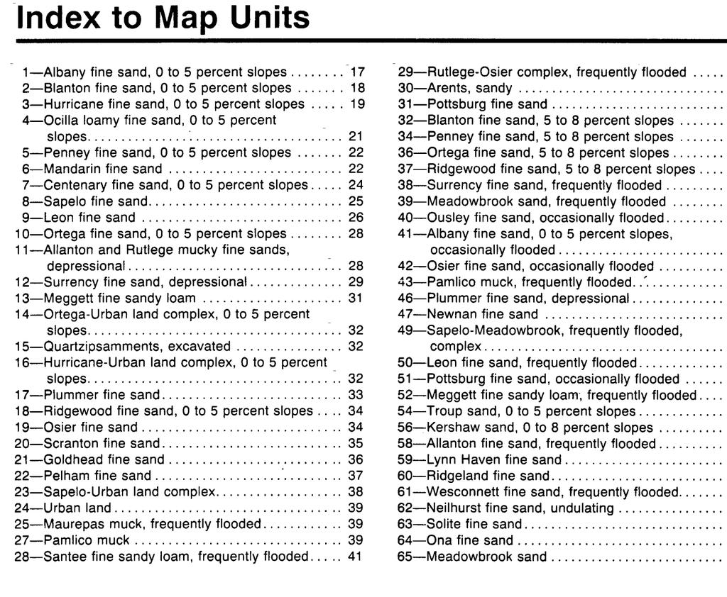
12 Clay County, Florida Map symbol and Component Percent Landform Hydric map unit name of map rating unit 8: Sapelo fine sand Sapelo, hydric 20 Flats Yes Rutlege 3 Depressions Yes Albany 10 Knolls No Sapalo, nonhydric 67 Flatwoods No 9: Leon fine sand Leon, hydric 10 Flats Yes Lynn Haven 3 Flats Yes Sapelo, hydric 3 Flats Yes Leon, nonhydric 70 Flatwoods No Sapelo, nonhydric 14 Flatwoods No 11: Allanton and Rutlege mucky fine Allanton 45 Depressions Yes sands, depressional Rutlege 35 Depressions Yes Surrency 5 Depressions Yes Sapelo, hydric 5 Flats Yes Leon, nonhydric 10 Flatwoods No 12: Surrency fine sand, depressional Surrency 80 Depressions Yes Leon, hydric 3 Flats Yes Meggett 3 Flats Yes Rutlege 3 Depressions Yes Santee 2 Flood plains Yes Plummer 9 Flatwoods No 13: Meggett fine sandy loam Meggett 85 Flats Yes Goldhead, nonhydric 15 Flatwoods No 17: Plummer fine sand Plummer, hydric 20 Flats Yes Pelham, nonhydric 15 Flatwoods No Plummer, nonhydric 65 Flatwoods No 19: Osier fine sand Osier, hydric 15 Flats Yes Rutlege 2 Depressions Yes Osier, nonhydric 65 Flatwoods No Albany 10 Knolls No Hurricane 8 Knolls No 20: Scranton fine sand Scranton, hydric 15 Flats Yes Leon, hydric 3 Flats Yes Rutlege 2 Depressions Yes Scranton 68 Flatwoods No Ridgewood 5 Knolls No Ona, nonhydric 3 Flatwoods No
13 Inherent Problems with Hydric Soil Lists There is a problem with hydric soil lists which may confuse users (Hurt and Carlisle. 1997). The presence of a soil on a hydric soil list does not mean that the soil is in fact hydric. This is only an interpretive rating. Just as is the case with all interpretations based on information in a published soil survey or other sources of estimated soil properties, hydric soil interpretations are confirmed by on-site investigations. Hydric soil indicators (Hurt and Vasilas. 2006) provides us a method of on-site confirmation of the presence or absence of a hydric soil.
14 Hydric Soil Indicators Field Indicators of Hydric Soils in the US (Vasilas, et.al. 2006) has been approved as the sole source document for hydric soil identification and delineation by the NRCS, US Army COE, EPA, and US Fish and Wildlife Service. It has also been approved as the sole source document for hydric soil identification and delineation by the State of Florida (DEP and Water Management Districts).

15 The beauty of the hydric soil indicators is that they provide us a method to prove or disproved the presence of a hydric soil based on something felt, seen, or smelled and not estimated or guessed.

16 Indicators are based on biogeochemical processes that occur when a soil is saturated or inundated.
17 Biogeochemical Processes Biogeochemical processes are processes that alter soil due to the interaction of its chemical composition and the animal and plant life it supports. Hydric soil indicators are based on several biogeochemical processes (Vepraskas. 1994) that occur when soils are saturated or inundated (this subject will be covered thoroughly in the lecture of redoximorphic features). Iron Carbon Carbon and Iron Carbon and/or Iron Carbon and Iron/Manganese Iron/Manganese Sulfur Algae The processes and the hydric soil indicator that result from the processes are reviewed in the next few slides. The indicators will be covered in depth during a later lecture. Ignore their being referenced for now; you may need to refer back after the next lecture.

18 Iron Twelve indicators are based on iron reduction, transformation, and differential accumulation: A13, A14, A15, S4, S5, F2, F3, F8, F9, F18, F19 and F20.

19 Carbon Nineteen indicators are based on carbon accumulation and differential decomposition: A1, A2, A3, A5, A6, A7, A8, A9, A10, S1, S2, S3, S7, S8, S9, F1, F11, F13, and F17.

20 Carbon and Iron Four indicators are based on carbon accumulation and differential decomposition and iron reduction, translocation, and differential accumulation: A11, A12, F6, and F7.

21 Carbon and/or Iron One indicator is based on carbon accumulation and differential decomposition and/or iron reduction, translocation, and differential accumulation: S6.

22 Carbon and Iron/Manganese One indicator is based on carbon accumulation and differential decomposition and iron/manganese reduction, translocation, and differential accumulation: F16.

23 Iron/Manganese One indicator is based on iron/manganese reduction, transformation, and differential accumulation: F12.

24 Sulfur One indicator is based on sulfur reduction: A4.

25 Algae One indicator is based on precipitation of calcium carbonate by algae: F10.
 in most LRRs")
26 Where do we begin our To determine whether an indicator is present or not it is critical to know where to begin looking. To determine whether a hydric soil indicator is present we would begin our observation of the soil in the photo to the right beneath the knife blade (below the fibric and hemic material) in most LRRs but where we begin our observations varies from region to region (next slide). observations?
27 Where to look for an Indicator by LRR (see slide 31) The soil surface is the very top of the material upon which standing nationwide when applying indicators A1 and A2 and in LRRs F, G, H, and M if the material beneath any mucky peat and/or peat is sandy. In LRR R the soil surface is the top of the mineral surface (underneath any and all fibric, hemic, and/or sapric material) except for application of A1 and A2. In the remaining LRRs and in LRRs F, G, H, and M if the material beneath any mucky peat and/or peat is not sandy the soil surface is the top of the muck or mineral surface (underneath any fibric and/or hemic material) except for application of A1 and A2.
 The current version is Version 6.")
28 Field Indicators of Hydric Soils in the US The remain portion of this lecture pertains to the publication Field Indicators of Hydric Soils in the US (Hurt and Vasilas 2006) The current version is Version 6.0; the picture to the right is of the cover to Version 3.2 (Hurt, et al. 1996)

29
30 Regionalization of Hydric Soil Indicators The NTCHS has approved each of the indicators for use in specific regions of the US (USDA, SCS. 1981). Most are based on Land Resource Regions (LRRs, next slide). Some are based on the smaller Major Land Resource Areas (MLRAs). Appendix 1 in Field Indicators of Hydric Soils in the US is a listing of the indicators approved for use in each LRR. A prime example of regionalization: Only the presence of muck is required in south Florida, as one goes North thicker layers are required. In New England (and other areas) muck (sapric material) occurs on upland soils so this indicator is not used in LRR R.

31
32 Basic Terms There are some basic terms used throughout that need explaining. These terms are defined here because they are used in the definitions of many of the indicators. Depleted Matrix - Indicators A11, A12, F3, F9, and F12. Gleyed Matrix Indicators A11, A12, A14, S4, and F2. Reduced Matrix Indicators A11,A12, A14, S4, F2, F3, F9, and F12. 70% masked by organic matter- Indicators A5, A11, A12, S7, S8, and S9.
33 Depleted Matrix For loamy and clayey soil material (and sandy soil material for application of Indicators A11 and A12), a depleted matrix refers to the volume of a soil horizon or subhorizon from which iron has been removed or transformed by processes of reduction and translocation to create colors of low chroma and high value. A, E and calcic horizons may have low chromas and high values and may therefore be mistaken for a depleted matrix; however, they are excluded from the concept of depleted matrix unless common or many, distinct or prominent redox concentrations as soft masses or pore linings are present. In some places the depleted matrix may change color upon exposure to air (Reduced Matrix), this phenomena is included in the concept of depleted matrix.
34 Depleted Matrix The following combinations of value and chroma identify a depleted matrix: 1. Matrix value 5 or more and chroma 1 with or without redox concentrations as soft masses and/or pore linings; or 2. Matrix value 6 or more and chroma 1 or 2 with or without redox concentrations as soft masses and/or pore linings; or 3. Matrix value 4 or 5 and chroma 2 and has 2 percent or more distinct or prominent redox concentrations as soft masses and/or pore linings; or 4. Matrix value 4 and chroma 1 and has 2 percent or more distinct or prominent redox concentrations as soft masses and/or pore linings.
35 Gleyed Matrix Soils with a gleyed matrix have the following combinations of hue, value, and chroma and the soils are not glauconitic: 1. 10Y, 5GY, 10GY, 10G, 5BG, 10BG, 5B, 10B, or 5PB with value 4 or more and chroma is 1; or 2. 5G with value 4 or more and chroma is 1 or 2; or 3. N with value 4 or more; or In some places the gleyed matrix may change color upon exposure to air (reduced matrix). This phenomena is included in the concept of gleyed matrix.
36 Depleted Depleted Gleyed 4/2, 5/2, 4/1 >5/1, >6/2 value >4, with 2% or more with or gley pages redox without redox of color concentrations concentrations charts

37 Depleted Matrix The range of colors for the depleted matrix is value 4 or more and chroma 1 or 2; however, colors of value 4 and chroma 1 or 2 and value 5 and chroma 2 must have redox concentrations.

38 Prominent Prominent Prominent Distinct Distinct Distinct Faint Faint Faint Matrix Color 10YR 4/2

39 Gleyed Matrix The range of colors for the gleyed matrix is value 4 or more on either of the two gley color charts.
40 Reduced Matrix A reduced matrix is a matrix that upon initial exposure fits the color requirements of either a depleted matrix or a gleyed matrix but changes color (redder hue) when exposed to air for about 30 minutes (Vepraskas. 1994). In the next slide a soil (left photo) with a depleted/gleyed matrix upon initial exposure was air dried for 7 days (right photo). This is a classic example of a reduced matrix. The most reduced areas turned the reddest after exposure. Some hue changes occurred after 30 minutes but the change was more dramatic after 7 days. The white bar in both photos is 1 cm long.


41 Reduced Matrix

42 The picture on the right is sandy soil material with (clockwise from top) 50, 60, and 70% masked with organic material. Organic carbon content of the samples are about 2, 3, and 4 % respectively. 70% Masked
 and dry soil (R).")
43 All color requirements (hue, value, and chroma) are for moist color. If dry, moisten to record color; if wet, allow to dry to moist state. This picture shows moist soil (L) and dry soil (R). Features are usually more readily identifiable in moist state; they may be missing if soil is too wet (let dry). Moist Color

44 Chroma 2 2+ Soil colors specified in the Indicators do not have decimal points listed; however, colors do occur between Munsell (Gretag/Macbeth. 2000) chips. Soil colors should not be rounded to qualify as meeting an indicator. For example: a soil matrix with a chroma between 2 and 3 should be listed as having a chroma of 2+. This soil material does not have a chroma 2 and would not meet any indicator that requires a chroma 2 or less.
45 Summary We have explained the Hydric Soil Definition, Hydric Soil Lists. Hydric Soil Indicators, and introduced Hydric Soil. The definition provides up the basis for this lecture, hydric soil lists are for off-site (office use), and the indicators provide us the best method of identifying and delineating hydric soils (field use). Evidence of flooding and ponding can be used as the sole source of evidence that an area has hydric soils if it has been shown that anaerobic conditions have been met but really should not be invoked. The presence of a soil on a hydric soil list does not mean that the soil is in fact hydric; it is only an interpretive rating.
46 Summary (cont.) Hydric soil indicators are based on several biogeochemical processes that occur when soils are saturated or inundated: Iron, Carbon, Carbon and Iron, Carbon and/or Iron, Carbon and Iron/Manganese, Iron/Manganese, Sulfur, and Algae. Field Indicators of Hydric Soils in the US (Hurt and Vasilas) provides the structure of the regionalization of hydric soil indicators and defines the terms depleted matrix, gleyed matrix, and reduced matrix. Moist colors should be recorded and, although colors do occur between Munsell chips, soil colors should not be rounded to qualify as meeting an indicator.
47 Literature Cited Environmental Laboratory Corps of Engineers Wetland Delineation Manual - Technical Report Y US Army Engineers Waterways Experiment Station, Vicksburg, MS. Federal Register. July 13, Changes in Hydric Soils of the United States. Washington, DC. (current Hydric Soil Definition). Hurt, G.W., and V.W. Carlisle Proper use of hydric soil terminology. Soil Survey Horizons, Vol. 38, No. 4, Madison, WI.
48 Literature Cited (cont.) Vasilas, L.M., G.W. Hurt, and C.V. Noble Field indicators of hydric soils in the United States (Version 7.0), USDA, NRCS, Fort Worth, TX. Xrite Munsell Color. New Windsor, NY. USDA, SCS Land Resource Regions and Major Land Resource Areas of the United States. USDA-SCS Agricultural Handbook 296. US Govt. Printing Off., Washington, DC. Vepraskas, M. J Redoximorphic Features for Identifying Aquic Conditions. Tech. Bulletin 301. North Carolina Ag. Research Service, North Carolina State Univ., Raleigh, North Carolina.
An Introduction to Hydric Soils and Hydric Soil Terminology. A word about the NTCHS. Wetlands
 An Introduction to Hydric Soils and Hydric Soil Terminology Based on deliberations of: The National Technical Committee for Hydric Soils (NTCHS). A word about the NTCHS The National Technical Committee
ACT PRESENTATION 5 AN INTRODUCTION TO HYDRIC SOILS AND HYDRIC SOIL TERMINOLOGY OCTOBER 2011
 ACT PRESENTATION 5 AN INTRODUCTION TO HYDRIC SOILS AND HYDRIC SOIL TERMINOLOGY OCTOBER 2011 An Introduction to Hydric Soils and Hydric Soil Terminology by: Wade Hurt, USDA, NRCS, NSSC/ University of Florida,
Field Indicators of Hydric Soils in the United States: Loamy and Clayey Soils
 Field Indicators of Hydric Soils in the United States: Loamy and Clayey Soils Field Indicators The publication Field Indicators of Hydric Soils in the US (Vasilas, Hurt, and Noble 2010) is the reference
An Explanation of the Hydric Soil Technical Standard and Normal Precipitation
 An Explanation of the Hydric Soil Technical Standard and Normal Precipitation From: National Technical Committee for Hydric Soils. 2001. Hydric Soil Technical Standard (Technical Note 11). http://soils.usda.gov/soil_us
Pocket Guide to Hydric Soils for Wetland Delineations in Massachusetts
 The Buzzards Bay National Estuary Program Pocket Guide to Hydric Soils for Wetland Delineations in Massachusetts Version 3.1 The Buzzards Bay National Estuary Program August, 2018 This document is a compilation
The Buzzards Bay National Estuary Program Pocket Guide to Hydric Soils for Wetland Delineations in Massachusetts. Version 2.1
 The Buzzards Bay National Estuary Program Pocket Guide to Hydric Soils for Wetland Delineations in Massachusetts Version 2.1 The Buzzards Bay National Estuary Program November, 2014 This document is a
The Buzzards Bay National Estuary Program Pocket Guide to Hydric Soils for Wetland Delineations in Massachusetts. Version 2
 The Buzzards Bay National Estuary Program Pocket Guide to Hydric Soils for Wetland Delineations in Massachusetts Version 2 The Buzzards Bay National Estuary Program March, 2014 This document is a compilation
The History and Use of Field Indicators of Hydric Soils in the United States
 The History and Use of Field Indicators of Hydric Soils in the United States Lenore Matula Vasilas Soil Scientist USDA NRCS Beltsville, MD 1970s Soil Taxonomy incorporates wet soils into the classification
HYDROLOGIC CRITERION FOR HYDRIC SOILS. M. J. Vepraskas, NC State University
 HYDROLOGIC CRITERION FOR HYDRIC SOILS M. J. Vepraskas, NC State University Is this a hydric soil? Yes, because it meets the definition of a hydric soil. Definition A hydric soil is a soil that formed under
The Buzzards Bay National Estuary Program Pocket Guide to Hydric Soils for Wetland Delineations in Massachusetts
 The Buzzards Bay National Estuary Program Pocket Guide to Hydric Soils for Wetland Delineations in Massachusetts The Buzzards Bay National Estuary Program September, 2013 This document is largely taken
Wetland Soils. Lecture outline: Importance of wetland soils
 Importance of wetland soils Wetland Soils Chemical transformations Chemical (nutrient) storage These affect plant growth and peat formation Lecture outline: What are soils? How does inundation change upland
HYDRIC SOILS. By Neal Svendsen Resource Soil Scientist Natural Resources Conservation Service Sept 2006
 HYDRIC SOILS By Neal Svendsen Resource Soil Scientist Natural Resources Conservation Service Sept 2006 Wetlands and Hydric Soils The term hydric soils proposed by Cowardin in 1979 Classification of Wetlands
Supplemental Guide for Seasonal High Water Table Indicators in Georgia s Onsite. Wastewater Manual Section C: Flatwoods Region.
 Supplemental Guide for Seasonal High Water Table Indicators in Georgia s Onsite Wastewater Manual Section C: Flatwoods Region Brant Phelps Non-Thesis Research Paper Advisor: Dr. Willie Harris November
Redoximorphic Features
 Redoximorphic Features Redoximorphic Features for Identifying Aquic Conditions, Technical Bulletin 301 NCSU, Raleigh, North Carolina. Order from: Dept. of Ag. Comm., Box 7603, NCSU, Raleigh, NC 27695-7603
Wetland Delineation. Richard L. Darden, Ph.D. U.S. Army Corps of Engineers Charleston District October 3, 2012 BUILDING STRONG
 Wetland Delineation Richard L. Darden, Ph.D. U.S. Army Corps of Engineers Charleston District October 3, 2012 Why Delineate Wetlands? To define the limits of federal jurisdiction, in accordance with current
Trip Report New Mexico Study of Field Indicators of Hydric Soils in the United States 6/23 6/27/2008
 Trip Report New Mexico Study of Field Indicators of Hydric Soils in the United States 6/23 6/27/2008 Objective Lenore Vasilas, NRCS, HQ; Jim Herrington, EPA, TX; Ken Scheffe, NRCS, NM; and Bob Hill, NRCS,
The Revolving (Evolving) Door of Hydric Soil Indicators
 Door of Hydric Soil Indicators") The Revolving (Evolving) Door of Hydric Soil Indicators A brief history lesson in Hydric Soil Identification (I) Cowardin et al. (1979; Classification of Wetlands and Deepwater Habitats of the US) coined
The Revolving (Evolving) Door of Hydric Soil Indicators A brief history lesson in Hydric Soil Identification (I) Cowardin et al. (1979; Classification of Wetlands and Deepwater Habitats of the US) coined
User Guide for Automated Wetland Determination Data Sheets
 Wetlands Regulatory Assistance Program ERDC/TN WRAP-17-1 User Guide for Automated Wetland Determination Data Sheets by Nathan T. Schulz and Jacob F. Berkowitz PURPOSE: The U.S. Army Corps of Engineers
Lecture 21: Soil Redox; Hydric Soils; Wetlands
 Lecture 21: Soil Redox; Hydric Soils; Wetlands Soil Oxidation-Reduction (Redox) Many Elements Exist in Multiple Oxidation States in Soils Oxygen: O 2 (0), H 2 O (-2) Carbon: CH 4 (-4), Organic C (-3 to
Swamp School. Eastern Mountains and Piedmont Region. Hydric Soil and Wetland Hydrology Indicators
 Scope Reference Materials The purpose of this procedure is to provide information on the hydric and Wetland Hydrology indicators for the Eastern Mountains and Piedmont Region. This procedure should be
Mineral Hydric Soil Morphology Part 1 of 2
 Mineral Hydric Soil Morphology Part 1 of 2 Ch. 7 Richardson & Vepraskas Outline: 1. Redox Reactions and Associated Soil Conditions 2. Principal Types of Morphological Features in Hydric Soils September
WETLAND GEOMORPHOLOGY, SOILS, AND FORMATIVE PROCESSES
 2 WETLAND GEOMORPHOLOGY, SOILS, AND FORMATIVE PROCESSES Randy K. Kolka and James A. Thompson The soil is where many of the hydrologic and biogeochemical processes that influence wetland function and ecology
The Relationship between the Properties and Features of Wetland Soils and the Adjacent Uplands
 The Relationship between the Properties and Features of Wetland Soils and the Adjacent Uplands By USDA Natural Resources Conservation Service Connecticut Staff Wetlands and watercourses are features of
Reactions & Processes Influenced by Soil Wetness. Topics for Consideration. Reactions and Processes Influenced by Soil Wetness
 Reactions & Processes Influenced by Soil Wetness Topics for Consideration A. Organic matter (OM) accumulation B. Some reduction effects induced by soil saturation C. Redoximorphic features D. Calcium carbonate
Hydromorphic Calcareous Soils of Western Wyoming. M.S. Soil Science Defense Matt King
 Hydromorphic Calcareous Soils of Western Wyoming M.S. Soil Science Defense Matt King Outline Part I: Wetland Background Part II: Spatial Analysis Part III: Mesocosm Experiment Part I: Wetlands Ecosystem
Red Soil Updates in MLRA 145
 Red Soil Updates in MLRA 145 MLRA 145-Connecticut Valley Auer Farm, Bloomfield Evaluated 6 soil pits in red till soils of a woodland soil catena and a wet meadow soil catena Wadsworth Estate, Middletown
Appendix C-3. Wetlands and Other Surface Waters Report
 Appendix C-3 Wetlands and Other Surface Waters Report WETLANDS AND OTHER SURFACE WATERS REPORT Hatchet Ridge Wind Energy Project Shasta County, California Prepared for: Hatchet Ridge Wind, LLC Portland,
PORT OF VANCOUVER, USA PARCEL 1A NE LAYDOWN WETLAND DELINEATION
 PORT OF VANCOUVER, USA PARCEL 1A NE LAYDOWN WETLAND DELINEATION February 2012 Prepared by: Port of Vancouver, USA 3103 NW Lower River Road Vancouver, Washington 98660 360.693.3611 TABLE OF CONTENTS INTRODUCTION...
SITE ANALYSIS. 1. Hydrophytic Vegetation: A predominance of plants that are typically adapted for life in saturated soils.
 Soil Mapping The soil mapping inventory completed by the Natural Resource Conservation Service was reviewed as a part of this assessment (fig. 4). This mapping identified the soils generally throughout
Western Mountains, Valleys, and Coast Interim Regional Supplement to the 1987 Wetlands Delineation Manual
 Western Mountains, Valleys, and Coast Interim Regional Supplement to the 1987 Wetlands Delineation Manual Bill Kirchner, PWS, US Fish & Wildlife Service Janet Morlan, PWS, Department of State Lands Mike
ADDITIONAL TABLES AND INFORMATION
 APPENDIX D: ADDITIONAL TABLES AND INFORMATION NE JACKSON SCHOOL ROAD (NE GRANT ST. - NW EVERGREEN RD.) PROJECT WASHINGTON COUNTY, OREGON Tax Lots Traversed by the Project Study Area 1N230AB00600 1N230BA04000
Prepared by: Rummel, Klepper & Kahl
 WETLAND DELINEATION REPORT Kutztown Road (SR 1033) Resurfacing and Bridge Replacement Upper Hanover Township, Montgomery County, Pennsylvania Prepared for: PennDOT District 6-0 Prepared by: Rummel, Klepper
Appendix C. Methodology
 Appendix C Methodology This appendix contains the following items: 1) The access notification letter sent by the Illinois Department of Transportation (IDOT) to all landowners within the study area; 2)
The Hydric Soil Technical Standard. Deliberations of: National Technical Committee for Hydric Soils (NTCSH)
") The Hydric Soil Technical Standard Deliberations of: National Technical Committee for Hydric Soils (NTCSH) NTCHS Recommendation for Application of the HSTS The NTCHS recommends that the HSTS be used to:
The Hydric Soil Technical Standard Deliberations of: National Technical Committee for Hydric Soils (NTCSH) NTCHS Recommendation for Application of the HSTS The NTCHS recommends that the HSTS be used to:
Guidelines for Conducting and Reporting Hydrologic Assessments of Potential Wetland Sites
 Wetlands Regulatory Assistance Program ERDC TN-WRAP-00-01 Guidelines for Conducting and Reporting Hydrologic Assessments of Potential Wetland Sites PURPOSE: This technical note provides guidance on performing
Wetland Soils, Hydrology, and Geomorphology
 TWO Wetland Soils, Hydrology, and Geomorphology C. RHETT JACKSON, JAMES A. THOMPSON, and RANDALL K. KOLKA WETLAND SOILS Landscape Position Soil Properties Soil Profiles Soil Processes Legal Differentiation
Using IRIS Tubes to Monitor Reduced Conditions in Soils Project Design
 Wetlands Regulatory Assistance Program ERDC TN-WRAP-09-1 Using IRIS Tubes to Monitor Reduced Conditions in Soils Project Design by Jacob F. Berkowitz PURPOSE: This document provides guidance for planning
I THOUGHT IT WAS JUST WET LAND: A GUIDE TO ENVIRONMENTAL PERMITTING FOR AIRPORTS ROAD SCHOOL 2018 SIMON DAVIES, SENIOR SCIENTIST MARCH 7, 2018
 I THOUGHT IT WAS JUST WET LAND: A GUIDE TO ENVIRONMENTAL PERMITTING FOR AIRPORTS ROAD SCHOOL 2018 SIMON DAVIES, SENIOR SCIENTIST MARCH 7, 2018 Definition Regulatory Definition - Those areas that are inundated
Wetland Determination/Delineation Whaley-Sharp Property Tippecanoe County, Lafayette, Indiana Patriot Project No E
 Wetland Determination/Delineation Whaley-Sharp Property Tippecanoe County, Lafayette, Indiana Patriot Project. 7-0390-0E Prepared For Mr. Rich Whaley Nationwide Insurance 306 New Britton Drive Fishers,
Custom Soil Resource Report for Okeechobee County, Florida
 United States Department of Agriculture Natural Resources Conservation Service A product of the National Cooperative Soil Survey, a joint effort of the United States Department of Agriculture and other
What is a Wetland? Common Wetland Names. Wetlands: Ecotones between Upland and Aquatic Systems. Matthew J. Gray University of Tennessee.
 What is a Wetland? Matthew J. Gray University of Tennessee Common Wetland Names Backwater swamps Peatland Estuary Vernal Pools Marsh Playa Fen Bog Bayou Spring Seep Humedales Wetlands: Ecotones between
39. WETLANDS Introduction. Wetlands and Waterbodies Cook Inlet Drainages
 39. WETLANDS 39.1 Introduction This chapter summarizes the wetlands and waterbodies study for the Cook Inlet drainages study area (Figure 39-1). The objectives of the study were to determine and map the
Estimating the Seasonal High Water Table: A Mix of Art & Science
 Estimating the Seasonal High Water Table: A Mix of Art & Science PONDS WORKSHOP - SJRWMD Devo Seereeram, Ph.D., P.E. This paper was originally written over 4 years ago & generated a lot of interest. The
Revelations in Lentic Soils:
 Revelations in Lentic Soils: Deciphering System Processes and Resource Conditions from Mud, Muck, and Peat Mark A. Gonzalez National Riparian Service Team Prineville, Oregon Calvin and Hobbes by Bill Watterson
RELATIONSHIPS BETWEEN SOIL MORPHOLOGY AND WATER TABLE LEVELS. Mark H. Stolt and Charles P. Morgan
 RELATIONSHIPS BETWEEN SOIL MORPHOLOGY AND WATER TABLE LEVELS Mark H. Stolt and Charles P. Morgan Acknowledgements USEPA National Community Decentralized Wastewater Treatment Demonstration Project Block
Deep River-Portage Burns Waterway Watershed 2015
 2.4 Soils Soil development is the product of the interaction of parent material, topography, climate, organisms and time. Understanding the types of soils that exist within a watershed and their characteristics
WETLAND DETERMINATION DATA FORM Eastern Mountains and Piedmont
 WETLAND DETERMINATION DATA FORM Eastern Mountains and Piedmont Project/Site: PIK-104-10.62 (PID: 83667) City/County: Pike Sampling Date: 5.30.13 Applicant/Owner: ODOT State: OH Sampling Point: 36 Investigator(s):
Wetlands Mapping in the Vicinity of the Mineral King Valley Cabins and Corral, Sequoia and Kings Canyon National Parks
 Wetlands Mapping in the Vicinity of the Mineral King Valley Cabins and Corral, Sequoia and Kings Canyon National Parks Joel Wagner, NPS Water Resources Division, National Park Service, PO Box 25287, Denver,
Soil, Landscape, Hydrology Relationships
 Soil, Landscape, Hydrology Relationships Soil Hydrologic Cycle Unsaturated Soils with Suction (Tension) Forces Water under a suction, pulls particles together. This water is not free water, it is not free
S.R. 430, Segment 250 Offset 0000, Greenfield Township Wetland Delineation
 S.R. 430, Segment 250 Offset 0000, Greenfield Township Wetland Delineation Date: October 30, 2007 Re: To: From: Erie County SR 430 Segment 250 Offset 0000 Wetland Delineation Mr. Todd Palmer Bridge Unit
Custom Soil Resource Report for Okeechobee County, Florida
 United States Department of Agriculture Natural Resources Conservation Service A product of the National Cooperative Soil Survey, a joint effort of the United States Department of Agriculture and other
Plant, Wildlife and Wetland Assessment
 WSU Project Site Plant, Wildlife and Wetland Assessment approximately 38 acres of the site would be in retained natural area, including passive use portions of the park and smaller natural areas in other
Hydric soil development in the Olentangy River Experimental Wetlands after five years of inundation
 Soils! 113 Hydric soil development in the Olentangy River Experimental Wetlands after five years of inundation Ashish P. Deshmukh and William J. Mitsch Environmental Science Graduate Program, The Ohio
PART I: ASSESSMENT OF WETLAND HYDROLOGY AT RESTORATION SITES PART II: CLIMATE CHANGE IMPACTS ON WETLAND HYDROLOGY BOUNDARIES. Mike Vepraskas NC State
 PART I: ASSESSMENT OF WETLAND HYDROLOGY AT RESTORATION SITES PART II: CLIMATE CHANGE IMPACTS ON WETLAND HYDROLOGY BOUNDARIES Mike Vepraskas NC State Do these sites have wetland hydrology? Restored and
Custom Soil Resource Report for Wright County, Minnesota
 United States Department of Agriculture Natural Resources Conservation Service A product of the National Cooperative Soil Survey, a joint effort of the United States Department of Agriculture and other
ATTACHMENT 4 USDA NRCS HYDRIC SOIL UNIT DESCRIPTIONS
 ATTACHMENT 4 USDA NRCS HYDRIC SOIL UNIT DESCRIPTIONS USDA NRCS descriptions of the 23 wetland soil units (hydric soils and soils with hydric inclusions) That occur within the proposed Marble River Wind
Custom Soil Resource Report for Colquitt and Cook Counties, Georgia
 United States Department of Agriculture Natural Resources Conservation Service A product of the National Cooperative Soil Survey, a joint effort of the United States Department of Agriculture and other
PACIFIC RIM SOIL & WATER, INC.
 PACIFIC RIM SOIL & WATER, INC. Lisa Palazzi 1220 4 th Avenue East Olympia, WA 98506 360-534-0346 (p) 360-236-7813 (f) December 16, 2008 Report Subject: Location: Preparer: Proposed Site Evaluation Protocol
Custom Soil Resource Report for St. Lucie County, Florida
 United States Department of Agriculture Natural Resources Conservation Service A product of the National Cooperative Soil Survey, a joint effort of the United States Department of Agriculture and other
Ensuring Soil Quality and Function in Wetland Creation and Restoration Efforts
 Ensuring Soil Quality and Function in Wetland Creation and Restoration Efforts W. Lee Daniels and many more from many places! http://www.landrehab.org Eric Stein, Principal Scientist, Southern California
WETLAND IDENTIFICATION AND DELINEATION REPORT. Milford Township Somerset County, Pennsylvania. Prepared By:
 State Route 653, Section 07B Bridge Replacement Over South Glade Creek WETLAND IDENTIFICATION AND DELINEATION REPORT Milford Township Somerset County, Pennsylvania Prepared By: PENNDOT Engineering District
Custom Soil Resource Report for St. Lucie County, Florida Gopherbroke Farms
 United States Department of Agriculture Natural Resources Conservation Service A product of the National Cooperative Soil Survey, a joint effort of the United States Department of Agriculture and other
WETLAND ANALYSIS REPORT. POINT NO POINT WETLAND HANSVILLE Kitsap County, Washington
 WETLAND ANALYSIS REPORT FOR THE POINT NO POINT WETLAND HANSVILLE Kitsap County, Washington Prepared For: Kitsap County Department of Surface and Storm Water Management 614 Division Street, MS-26 Port Orchard,
Wetland Report. Prepared For: Steven Tung. Site Address: Cooks Hill Road, Centralia. Tax Parcel Number: Date: January 31, 2016
 Wetland Report Prepared For: Steven Tung Site Address: Cooks Hill Road, Centralia Tax Parcel Number: 211791 Date: January 31, 216 Prepared By: Environmental Design, LLC. Septic Design Wetlands Mapping
Indiana University Campus Wetland Survey 2010 Final Report Kari Metcalf
 Indiana University Campus Wetland Survey 2010 Final Report Kari Metcalf INTRODUCTION Following recommendations by the Indiana Department of Environmental Management, Indiana University inventoried jurisdictional
The Color of Soil. Introduce the Ac vity. Ac vity I: The Color of Soil W 331 E
 Project Area: Environmental Science Skill Level: Beginner Intermediate Learner Outcomes: Understand what makes soils different colors Classify soil color using a modified Munsell Color Chart TN Science
City Code (in separate font) is used as the outline to ensure all required information is provided.
 is used as the outline to ensure all required information is provided.") February 12, 2018 Brian Bowen P.O. Box 42 Buckley, WA 98321 bowen_construction@msn.com RE: Parcel #: 2520069137 Watson St. N Enumclaw, WA Dear Brian: Introduction This letter serves as a wetland and stream
February 12, 2018 Brian Bowen P.O. Box 42 Buckley, WA 98321 bowen_construction@msn.com RE: Parcel #: 2520069137 Watson St. N Enumclaw, WA Dear Brian: Introduction This letter serves as a wetland and stream
Wetland Functions in the Watershed: Part 1 Watershed Elements. USDA NRCS Module Name 1
 Wetland Functions in the Watershed: Part 1 Watershed Elements USDA NRCS Module Name 1 Objectives Define Landscape Elements in the Watershed Describe Hydrologic Connections Between Elements Introduce Soil
Custom Soil Resource Report for Polk County, Wisconsin
 United States Department of Agriculture Natural Resources Conservation Service A product of the National Cooperative Soil Survey, a joint effort of the United States Department of Agriculture and other
Whatcom County Code Chapter Critical Areas Regulations: Wetlands, Streams, and Wildlife
 Whatcom County Code Chapter 16.16 Critical Areas Regulations: Wetlands, Streams, and Wildlife August 20, 2014 Wayne Fitch Natural Resources Supervisor Erin Page Natural Resources Planner III CAO Basics
Hydrologic Soil Group Knowledge Matrix
 Hydrologic Soil Group Knowledge Matrix Refinement Of Soils Parameter For MPCA s Minimum Impact Design Standards Calculator and Stand-Alone Hydrologic Soil Group Determination Funding for this project was
Urban Soil Conservation and Management
 Urban Soil Conservation and Management Urban Soil include those located in: Cities in park areas Recreation areas Community gardens Green belts Lawns Septic absorption fields Sediment basins We need a
Appendix E Preliminary Jurisdictional Wetland Delineation Report, JYL 2008
 Appendix E Preliminary Jurisdictional Wetland Delineation Report, JYL 2008 PRELIMINARY JURISDICTIONAL WETLAND DELINEATION REPORT A portion of USS 3819 and 2664: Horton Lot and Statter Harbor Juneau, Alaska
History of Wetland Mitigation at the North Carolina Wetlands Restoration Program and Ecosystem Enhancement Program
 History of Wetland Mitigation at the North Carolina Wetlands Restoration Program and Ecosystem Enhancement Program Mac Haupt, LSS- Principal, Wetland & Stream Mitigation & Closeout Services (Formerly at
Custom Soil Resource Report for Columbus County, North Carolina
 United States Department of Agriculture Natural Resources Conservation Service A product of the National Cooperative Soil Survey, a joint effort of the United States Department of Agriculture and other
Wetland Functions LACUSTRINE FRINGE COOS BAY, OR
 Wetland Functions LACUSTRINE FRINGE COOS BAY, OR Introduction- This Module will: Introduce the terms Functions and Values Explain the need for Measurable Variables Explain how Variable ratings are combined
Routine Wetland Determination
 Project/Site: 60-0008-0560-0032 Applicant/owner: PENNDOT, Eng. District 1-0 Investigator(s): Christopher R. Wolfgong Routine Wetland Determination DATA FORM 1 (Revised) 1987 Corps Wetland Delineation Manual)
Soils and Wetlands. What s About to Hit the Pit
 Soils and Wetlands What s About to Hit the Pit http://www.usace.army.mil/cw/cecwo/reg/reg_supp.htm Why Regionalize? Recommendations A new and consistent system of wetland delineation regions is needed,
Appendix I. Potential Adverse Change to Wetland Function Methodology and Results
 Appendix I Potential Adverse Change to Wetland Function Methodology and Results Technical Memorandum North Florida Regional Water Supply Plan Potential Adverse Change to Wetland Function January 3, 2017
Soils of Great Salt Lake Wetlands: Hydric Indicators and Common Features
 Soils of Great Salt Lake Wetlands: Hydric Indicators and Common Features Christine Rohal, Karin Kettenring, Rebekah Downard, and Mark Larese-Casanova Department of Watershed Sciences, Quinney College of
Waters of the U.S. Revisions
 City and County of Denver January 12 2015 Denver International Airport Waters of the U.S. Revisions Sarah Reeves, Brown and Caldwell Waters of the US (WOTUS) Clean Water Act... protects waters to keep
Coloration Changes of Geologic Media After Addition of Gasoline, Diesel Fuel, and Ethylbenzene
 Journal of Soil Contamination, 5(1):(1996) Coloration Changes of Geologic Media After Addition of Gasoline, Diesel Fuel, and Ethylbenzene James Dragun, Ph.D., Rachel Gambino, and Wendy Kuhn, Ph.D. The
Wetland Delineations near Shediac, New Brunswick
 Wetland Delineations near Shediac, New Brunswick A report to the New Brunswick Department of Environment and Local Government Theo Popma, Overdale Environmental Inc., tpopma@nb.sympatico.ca, 506-227-4829
3 Parameters Federal/Corps. Wetland Delineation. Vegetation. Monterey County Wetlands Workshop 2/24/2014
 3 Parameters Federal/Corps Vegetation Wetland Delineation Soils Hydrology 3 Parameters but only 1 needed for State/Coastal Commission Vegetation Vegetation Soils Hydrology Sponsor: Elkhorn Slough Coastal
Appendix E Agency Coordination
 Sustainable Airport Master Plan Appendix E Agency Coordination. Appendix United States Department of Agriculture Natural Resources Conservation Service A product of the National Cooperative Soil Survey,
Biogeochemistry of Wetlands
 Institute of Food and Agricultural Sciences (IFAS) Biogeochemistry of Wetlands Si Science and da Applications Biogeochemical Properties of Wetlands Wetland Biogeochemistry Laboratory Soil and Water Science
Custom Soil Resource Report for Pamlico County, North Carolina
 United States Department of Agriculture Natural Resources Conservation Service A product of the National Cooperative Soil Survey, a joint effort of the United States Department of Agriculture and other
2008 Southern Regional Cooperative Soil Survey Conference. Ad Hoc Committee on Subaqueous Soil Interpretations July 14, 2008
 2008 Southern Regional Cooperative Soil Survey Conference Ad Hoc Committee on Subaqueous Soil Interpretations July 14, 2008 Soil scientists are now investigating aquatic bottoms. USDA-NRCS aims to survey
WETLAND DELINEATION REPORT
 WETLAND DELINEATION REPORT WHITMORE LAKE LOT WASHTENAW COUNTY, MICHIGAN JULY 2015 PREPARED FOR: WASHTENAW COUNTY PARKS AND RECREATION 2230 SOUTH PLATT ROAD ANN ARBOR, MICHIGAN 48104 PREPARED BY: THE MANNIK
The Big Picture SOILS, WETLANDS AND DEVELOPMENT SOILS OVERVIEW BRUCE BARBER. PWS, Soil Scientist Certified Ecologist CORNERSTONE ASSOCIATES
 SOILS, WETLANDS AND DEVELOPMENT BRUCE BARBER PWS, Soil Scientist Certified Ecologist CORNERSTONE ASSOCIATES 1770 CENTRAL STREET YORKTOWN HEIGHTS NY 10598 PHONE: (914) 962-7733 FAX: (914) 962-0330 EMAIL:
Background. Literature Review
 Ms. Joanna Helms Economic Development Director Town of Apex 73 Hunter Street P.O. Box 250 Apex, North Carolina 27502 October 23, 2015 Reference: Report of Wetland Determination Cash Perkins Site ECS Project
PREDICTING CLIMATE CHANGE IMPACTS ON WETLAND BOUNDARIES IN BENCHMARK SOILS. M. J. Vepraskas and C.P. Niewoehner, NC State University
 PREDICTING CLIMATE CHANGE IMPACTS ON WETLAND BOUNDARIES IN BENCHMARK SOILS M. J. Vepraskas and C.P. Niewoehner, NC State University Is Climate Changing? Columbia Glacier (Alaska) 1980 2005 Source: NASA
Custom Soil Resource Report for Dallam County, Texas
 United States Department of Agriculture Natural Resources Conservation Service A product of the National Cooperative Soil Survey, a joint effort of the United States Department of Agriculture and other
ABBREVIATED NOTICE OF RESOURCE AREA DELINEATION YANKEE NUCLEAR POWER STATION ROWE, MASSACHUSETTS MARCH 2004 PREPARED FOR
 ABBREVIATED NOTICE OF RESOURCE AREA DELINEATION YANKEE NUCLEAR POWER STATION ROWE, MASSACHUSETTS MARCH 2004 PREPARED FOR YANKEE ATOMIC ELECTRIC COMPANY 49 YANKEE ROAD ROWE, MASSACHUSETTS 01367 PREPARED
Assured Wetland Delineation Report
 Assured Wetland Delineation Report Alliant Energy Center City of Madison, Dane County, WI Stantec Project #: 193703955 Lead Delineator: Jeff Kraemer Prepared for: Mark Clarke Executive Director, Alliant
EXAMINATION OF THE WETLAND HYDROLOGIC CRITERION AND ITS APPLICATION IN THE DETERMINATION OF WETLAND HYDROLOGIC STATUS
 EXAMINATION OF THE WETLAND HYDROLOGIC CRITERION AND ITS APPLICATION IN THE DETERMINATION OF WETLAND HYDROLOGIC STATUS W.F. Hunt, 111, R.W. Skaggs, G.M. Chescheir and D.M. Amatya Department of Biological
ABSTRACT. although little research has evaluated the effects of organic additions on the development
 ABSTRACT Title of Document: REDOXIMORPHIC FEATURES INDUCED BY ORGANIC AMENDMENTS AND SIMULATED WETLAND HYDROLOGY Adam Lincoln Gray, Master of Science, 2010 Directed By: Professor Martin C. Rabenhorst,
A Guide for Matching Oak Species with Sites during Restoration of Loess-influenced Bottomlands in the West Gulf Coastal Plain PB1800
 A Guide for Matching Oak Species with Sites during Restoration of Loess-influenced Bottomlands in the West Gulf Coastal Plain PB1800 1 A Guide for Matching Oak Species with Sites during Restoration of
Transport & Transformation of chemicals in an ecosystem, involving numerous interrelated physical, chemical, & biological processes
 OPEN Wetland Ecology Lectures 14-15-16 Wetland Biogeochemistry What is biogeochemical cycling? Transport & Transformation of chemicals in an ecosystem, involving numerous interrelated physical, chemical,
Wetland Observations
 Wetland Observations What is a wetland?/ Wetland Delineation Adapted from: Run for the Border and Do You Dig Wetland Soil in WOW! Wonders of Wetlands: An Educator s Guide. Bozeman: The Watercourse and