WETLAND DELINEATION REPORT
|
|
|
- Pamela Holt
- 6 years ago
- Views:
Transcription
1 WETLAND DELINEATION REPORT WHITMORE LAKE LOT WASHTENAW COUNTY, MICHIGAN JULY 2015 PREPARED FOR: WASHTENAW COUNTY PARKS AND RECREATION 2230 SOUTH PLATT ROAD ANN ARBOR, MICHIGAN PREPARED BY: THE MANNIK SMITH GROUP, INC INDIAN WOOD CIRCLE MAUMEE, OHIO 43537
2 WETLAND DELINEATION REPORT WHITMORE LAKE LOT WASHTENAW COUNTY, MICHIGAN *PREPARED BY: KATIE L. SIMON ENVIRONMENTAL SCIENTIST REVIEWED BY: KEITH CARR ECOLOGICAL TEAM LEADER
3 SECTION: TABLE OF CONTENTS PAGE NO.: 1.0 INTRODUCTION METHODS RESULTS AGENCY RESOURCE INFORMATION WETLAND DELINEATION UPLANDS SUMMARY... 4 TABLES TABLE 3.1 SOIL TYPES ON THE SITE... 3 TABLE 3.2 SUMMARY OF WETLANDS... 3 FIGURES FIGURE 1 FIGURE 2 FIGURE 3 APPENDICES APPENDIX A APPENDIX B SITE LOCATION NWI/ SOILS CLASSIFICATION SUFACE WATER DELINEATION WETLAND DETERMINATION DATA SHEETS SITE PHOTOGRAPHS THE MANNIK & SMITH GROUP, INC. WASP0109.DelineationReport.kls.docx i
4 1.0 INTRODUCTION On July 28, 2015, The Mannik & Smith Group, Inc. (MSG) performed a wetland delineation for a proposed parking area on the Whitmore Lake Preserve in Whitmore Lake, Washtenaw County, Michigan (Site) (Figure 1). The purpose of a wetland delineation is to identify any areas on the Site that could be considered a jurisdictional wetland or surface water. Federal regulations define a jurisdictional wetland as an area that is inundated or saturated by surface or ground water at a frequency and duration sufficient to support, and that under normal circumstances does support, a prevalence of vegetation typically adapted for life in saturated soil conditions. According to current wetland criteria, a wetland has: (1) hydric (i.e., wetland) soils, (2) evidence of inundated or saturated conditions (wetland hydrology), and (3) a predominance of wetland vegetation. When all three of these criteria are met, a wetland is present and is potentially subject to Federal and/or State regulations and permitting. In a wetland delineation, data are collected concerning the vegetation, soils and hydrology present in representative plant communities to determine if the criteria for a jurisdictional wetland are met, and the wetland/non-wetland boundaries are then flagged. The wetland/non-wetland boundaries and the sample locations are surveyed and placed on a wetland delineation figure. From the wetland delineation figure, the acreage of each wetland can then be calculated. A preliminary determination is also made as to whether each wetland is regulated based on Michigan Department of Environmental Quality s (MDEQ) Part 301 and 303 guidelines. THE MANNIK & SMITH GROUP, INC. 1 WASP0109.DelineationReport.kls.docx
5 2.0 METHODS MSG performed the wetland delineation in accordance with the 2010 Regional Supplement to the Corps of Engineers Wetland Delineation Manual: Midwest, Version 2.0. Wetlands were defined as any area on the property that contained a predominance of wetland vegetation, hydric soils and positive indicators of wetland hydrology. Sample plots for vegetation, soils and hydrology were placed on either side of the wetland boundary. The wetland/upland boundary was surveyed using a Trimble Geo XH GPS receiver. The wetland and upland data sheets that describe each plot are included in Appendix A. Digital images of each wetland were taken of each wetland and are included in Appendix B. After the wetland has been delineated, MSG also described the regulatory status of each wetland based on MDEQ Part 301 and 303 guidelines. To finalize this wetland delineation, a field review by MDEQ will be necessary. THE MANNIK & SMITH GROUP, INC. 2 WASP0109.DelineationReport.kls.docx
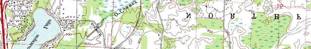
6 3.0 RESULTS 3.1 Agency Resource Information The USGS Quadrangle map for Hamburg, MI (1965, Revised 1983) and South Lyon, MI (1965, Revised 1983) Quadrangles indicate that the study area has elevations varying from 910 to 930 (Figure 1). A review of the National Wetland Inventory did not indicate the presence of any wetlands on the Site (Figure 2). Two soil units are mapped on the Site by the U.S. Department of Agriculture, Natural Resources Conservation Service (NRCS). Soils information for the Site is presented in Table 3.1 and mapped on Figure 2. One soil unit mapped for the Site is listed as having hydric inclusions in Washtenaw County, Michigan. Table 3.1 Soil Types on the Site Soil Type Map Unit Hydric? With Hydric Inclusions? Glynwood loam, 2 to 6 percent slopes MoB No Yes Morley loam, 6 to 12 percent slopes MoC No No 3.2 Wetland Delineation One wetland (Wetland A) comprised of acre was identified on the Site (Figure 3). To define the wetland boundaries, two sample points were collected (SP-1 and SP-2). Wetland determination data forms are included in Appendix A and site photographs are included in Appendix B. Based on Wetland A s proximity to an observed stream, MSG has determined that Wetland A would be regulated in the State of Michigan. A field review by MDEQ will be necessary in order to finalize the regulatory status of the wetland. Table 3.2 Summary of Wetlands Wetland Delineated Acreage within Study Area Wetland Type 1 Regulatory Status 2 Wetland A PEM Regulated Total wetland community type: PEM=palustrine emergent; PSS= palustrine scrub/shrub; PFO=palustrine forested and POW=palustrine open water 2 regulatory status determined based on MDEQ Part 301 and 303 guidelines Wetland A Wetland A was delineated as acre and is located in the southwest portion of the Site (Figure 3). The soil profile consisted of a twelve inch layer of 10YR 3/2 silty clay loam soil with 50% dark yellowish brown (10YR 3/4) redox features. Positive indicators of wetland hydrology included saturation, geomorphic position and a positive FAC-neutral test. Dominant vegetation consisted of hydrophytic vegetation such as: reed canary grass (Phalaris arundinacea: FACW) and box elder (Acer negundo: FAC). 3.3 Uplands One sample point was collected in an upland area (SP-2). SP-2 was dominated with autumn olive (Elaegnus umbellata: UPL), red fescue (Festuca rubra: FACU), goldenrod (Solidago sp.: FACU) and poison ivy (Toxicodendron radicans: FAC). The soil profile consisted of a six inch layer of 10YR 4/6 sandy silt soil. This was underlain by a six inch layer of 10YR 5/3 clayey silt soil with 50% dark yellowish brown (10YR 4/4) redox features. No signs of hydrology were observed. THE MANNIK & SMITH GROUP, INC. 3 WASP0109.DelineationReport.kls.docx
7 4.0 SUMMARY A wetland delineation was completed for a small proposed parking area on the Whitmore Lake Preserve on July 28, One wetland (Wetland A), comprised of acre, was identified on the Site. Based on Wetland A s proximity to an observed stream, MSG has determined that Wetland A would be regulated in the State of Michigan. A field review by MDEQ will be necessary in order to finalize the regulatory status of each wetland. THE MANNIK & SMITH GROUP, INC. 4 WASP0109.DelineationReport.kls.docx
8 FIGURES


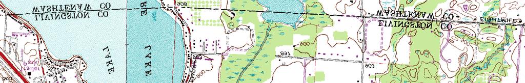

9 Path: W:\Projects\Projects U-Z\WASP0106\ENGAPPS\wasp0109_siteloc.mxd Date Saved: 7/29/2015 2:05:23 PM Figure 1: Site Location Whitmore Lake Preserve Washtenaw County, Michigan Legend Study Area Whitmore Lake Preserve Notes USGS Quadrangles, 7.5' Series Topographic Hamburg, MI 1965 Revised 1983 South Lyon, MI 1965 Revised 1983 Feet 0 1,000 2,000 Ë

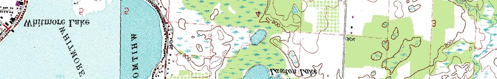
10 Path: W:\Projects\Projects U-Z\WASP0106\ENGAPPS\wasp0109_NWISoils.mxd Date Saved: 7/29/2015 2:02:11 PM W Hn So BbB Pe W BbB Pe NOLLAR RD MoC BbB MoB Br MmB SEVEN MILE RD Figure 2: NWI/Soils Classification Whitmore Lake Preserve Washtenaw County, Michigan CoB CoB Legend Study Area Whitmore Lake Preserve Soils Classification Wetland Type Ë Feet MmB Freshwater Emergent Freshwater Forested/Shrub Freshwater Pond Lake Other Freshwater Riverine CoB Notes The Washtenaw County photography, dated April 2010, is provided by SEMCOG. The soils data is provided by the U.S. Department of Agriculture, Natural Resources Conservation Service. The NWI data is provided by the U.S. Department of the Interior, Fish and Wildlife Service.

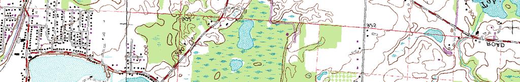
11 Path: W:\Projects\Projects U-Z\WASP0106\ENGAPPS\wasp0109_wets.mxd Date Saved: 7/29/2015 2:02:54 PM SEVEN MILE RD. Legend Sample Plot Wetland Study Area Whitmore Lake Preserve SP1 SP2 Figure 3: Surface Water Delineation Whitmore Lake Preserve Washtenaw County, Michigan Wetland A Ac. Notes NOLLAR RD. The Washtenaw County photography, dated April 2010, is provided by SEMCOG.. Feet Ë
12 APPENDIX A WETLAND DELINEATION DATA FORMS
13 WASP0109 Whitmore Lake/ Washtenaw 7/28/15 WASHTENAW COUNTY PARKS AND RECREATION MI SP-1 K. CARR, K. SIMON S9 T1S R6E depression concave Glynwood loam, 2to6percent slopes NONE Wetland A Acer negundo 30 FAC Phalaris arundinacea 85 FACW Typha latifolia 10 OBL Lythrum salicaria 5 OBL 100 0
14 YR 3/ YR 3/4 50 C M silty clay loam 0
15 WASP0109 Whitmore Lake/ Washtenaw 7/28/15 WASHTENAW COUNTY PARKS AND RECREATION MI SP-2 K. CARR, K. SIMON S9 T1S R6E convex Glynwood loam, 2 to 6 percent slopes NONE Elaeagnus umbellata 15 UPL Juniperus virginiana 5 FACU 0 Quercus alba 5 FACU 0 Fraxinus pennsylvanica 5 FACW 0 unknown birch Festuca rubra 70 FACU Solidago sp. 45 FACU 115 Toxicodendron radicans 15 FAC 15
16 SP YR 4/6 100 sandy silt trace of clay and gravel, dry YR 5/ YR 4/4 59 clayey silt some sand and gravel, dry
17 APPENDIX B SITE PHOTOGRAPHS
.")


.")

18 Photo 1: Sample point 1 (SP-1). Photo 2: Wetland A looking northeast. Photo 3: Wetland A looking south. Photo 4: Sample point 2 (SP-2) Indian Wood Circle, Maumee, Ohio Tel: Fax: Whitmore Lake Preserve Photo Page 1 MSG Project WASP0109
Prepared by: Rummel, Klepper & Kahl
 WETLAND DELINEATION REPORT Kutztown Road (SR 1033) Resurfacing and Bridge Replacement Upper Hanover Township, Montgomery County, Pennsylvania Prepared for: PennDOT District 6-0 Prepared by: Rummel, Klepper
Appendix C-3. Wetlands and Other Surface Waters Report
 Appendix C-3 Wetlands and Other Surface Waters Report WETLANDS AND OTHER SURFACE WATERS REPORT Hatchet Ridge Wind Energy Project Shasta County, California Prepared for: Hatchet Ridge Wind, LLC Portland,
WETLAND DETERMINATION DATA FORM Eastern Mountains and Piedmont
 WETLAND DETERMINATION DATA FORM Eastern Mountains and Piedmont Project/Site: PIK-104-10.62 (PID: 83667) City/County: Pike Sampling Date: 5.30.13 Applicant/Owner: ODOT State: OH Sampling Point: 36 Investigator(s):
I THOUGHT IT WAS JUST WET LAND: A GUIDE TO ENVIRONMENTAL PERMITTING FOR AIRPORTS ROAD SCHOOL 2018 SIMON DAVIES, SENIOR SCIENTIST MARCH 7, 2018
 I THOUGHT IT WAS JUST WET LAND: A GUIDE TO ENVIRONMENTAL PERMITTING FOR AIRPORTS ROAD SCHOOL 2018 SIMON DAVIES, SENIOR SCIENTIST MARCH 7, 2018 Definition Regulatory Definition - Those areas that are inundated
Wetland Determination/Delineation Whaley-Sharp Property Tippecanoe County, Lafayette, Indiana Patriot Project No E
 Wetland Determination/Delineation Whaley-Sharp Property Tippecanoe County, Lafayette, Indiana Patriot Project. 7-0390-0E Prepared For Mr. Rich Whaley Nationwide Insurance 306 New Britton Drive Fishers,
Appendix E Preliminary Jurisdictional Wetland Delineation Report, JYL 2008
 Appendix E Preliminary Jurisdictional Wetland Delineation Report, JYL 2008 PRELIMINARY JURISDICTIONAL WETLAND DELINEATION REPORT A portion of USS 3819 and 2664: Horton Lot and Statter Harbor Juneau, Alaska
WETLAND IDENTIFICATION AND DELINEATION REPORT. Milford Township Somerset County, Pennsylvania. Prepared By:
 State Route 653, Section 07B Bridge Replacement Over South Glade Creek WETLAND IDENTIFICATION AND DELINEATION REPORT Milford Township Somerset County, Pennsylvania Prepared By: PENNDOT Engineering District
SITE ANALYSIS. 1. Hydrophytic Vegetation: A predominance of plants that are typically adapted for life in saturated soils.
 Soil Mapping The soil mapping inventory completed by the Natural Resource Conservation Service was reviewed as a part of this assessment (fig. 4). This mapping identified the soils generally throughout
Wetland Delineation. Richard L. Darden, Ph.D. U.S. Army Corps of Engineers Charleston District October 3, 2012 BUILDING STRONG
 Wetland Delineation Richard L. Darden, Ph.D. U.S. Army Corps of Engineers Charleston District October 3, 2012 Why Delineate Wetlands? To define the limits of federal jurisdiction, in accordance with current
Indiana University Campus Wetland Survey 2010 Final Report Kari Metcalf
 Indiana University Campus Wetland Survey 2010 Final Report Kari Metcalf INTRODUCTION Following recommendations by the Indiana Department of Environmental Management, Indiana University inventoried jurisdictional
PORT OF VANCOUVER, USA PARCEL 1A NE LAYDOWN WETLAND DELINEATION
 PORT OF VANCOUVER, USA PARCEL 1A NE LAYDOWN WETLAND DELINEATION February 2012 Prepared by: Port of Vancouver, USA 3103 NW Lower River Road Vancouver, Washington 98660 360.693.3611 TABLE OF CONTENTS INTRODUCTION...
Hydrophytic Vegetation Present? Yes No Hydric Soil Present? Yes No Wetland Hydrology Present? Yes No Remarks:
 Project/Site: North Branch Pigeon Creek Mitigation Bank City/County: Eighty Four/ Washington Sampling Date: 1/15/13 Applicant/Owner: First Pennsylvania Resource, LLC. State: PA Sampling Point: FDS-4 Investigator(s):
Legend FIGURE 2 ENLOW FORK RESTORATION SITE. ENVIRONMENTAL INVENTORY MAP DtF WASHINGTON COUNTY, PENNSYLVANIA REFERENCE
 Fa DtD WeD WeD CaB WeC WeC DtD WeD WeD CaB CaB 5 Feet.5.1 FIGURE 2 ENLOW FORK RESTORATION SITE CaB ENVIRONMENTAL INVENTORY MAP WASHINGTON COUNTY, PENNSYLVANIA Document Path: Y:\84\33362-RES_2WAS2_Carpent\GIS\Wetland
ENVIRONMENTAL ASSESSMENT FORM (E.A. Form)
") 3930-PM-WM0017A Rev. 11/2001 COMMONWEALTH OF PENNSYLVANIA DEPARTMENT OF ENVIRONMENTAL PROTECTION and U.S. ARMY CORPS OF ENGINEERS ENVIRONMENTAL ASSESSMENT FORM (E.A. Form) PART 1 - RESOURCE IDENTIFICATION
3930-PM-WM0017A Rev. 11/2001 COMMONWEALTH OF PENNSYLVANIA DEPARTMENT OF ENVIRONMENTAL PROTECTION and U.S. ARMY CORPS OF ENGINEERS ENVIRONMENTAL ASSESSMENT FORM (E.A. Form) PART 1 - RESOURCE IDENTIFICATION
Wetland Assessment Report for Hawk Nest Park
 Wetland Assessment Report for Hawk Nest Park Location: A 20.18-acre parcel, located within part of the Hawk Nest Condominium development and further located within Section 36, Dewitt Township, Clinton
April 22, Mr. Mark Frazier U.S. Army Corps of Engineers Kansas City Regulatory Office 601 East 12 th Street Kansas City, MO 64106
 April 22, 2010 Mr. Mark Frazier U.S. Army Corps of Engineers Kansas City Regulatory Office 601 East 12 th Street Kansas City, MO 64106 Wetland Delineation Report and U.S. Army Corps of Engineers Permit
Wetland Delineation for the 53 rd Street Overpass Project Corvallis, Oregon
 Wetland Delineation for the 53 rd Street Overpass Project (Township 12 South, Range 5 West, Section 4 West end of Tax Lot 120 & north side of Union Pacific right-of-way) Prepared for Benton County Public
Plant, Wildlife and Wetland Assessment
 WSU Project Site Plant, Wildlife and Wetland Assessment approximately 38 acres of the site would be in retained natural area, including passive use portions of the park and smaller natural areas in other
Ordinary High Water Mark
 Ordinary High Water Mark Town of Long Beach Advisory Plan Commission Hearing on The Proposed Lake Michigan Shoreline Preservation and Enhancement Overlay District Ordinance May 24, 2018 Ordinary High Water
Wetland and Waterbody Delineation PORT OF EAST ST. LOUIS NORTH CAHOKIA TRACT SAUGET, ILLINOIS. October Prepared for: TERRA ENGINEEIRNG, LTD.
 Wetland and Waterbody Delineation PORT OF EAST ST. LOUIS NORTH CAHOKIA TRACT SAUGET, ILLINOIS October 2013 Prepared for: TERRA ENGINEEIRNG, LTD. SCI No. 2013-3194.30 Page E-1 of 18 October 23, 2013 Mr.
Routine Wetland Determination
 Project/Site: 60-0008-0560-0032 Applicant/owner: PENNDOT, Eng. District 1-0 Investigator(s): Christopher R. Wolfgong Routine Wetland Determination DATA FORM 1 (Revised) 1987 Corps Wetland Delineation Manual)
S.R. 430, Segment 250 Offset 0000, Greenfield Township Wetland Delineation
 S.R. 430, Segment 250 Offset 0000, Greenfield Township Wetland Delineation Date: October 30, 2007 Re: To: From: Erie County SR 430 Segment 250 Offset 0000 Wetland Delineation Mr. Todd Palmer Bridge Unit
WETLAND IDENTIFICATION AND DELINEATION REPORT
 WETLAND IDENTIFICATION AND DELINEATION REPORT State Route 0850, Section A06; Bridge Replacement over Laurel Run Tuscarora Township, Juniata County, Pennsylvania Prepared By: The Pennsylvania Department
WETLAND DETERMINATION DATA FORM Arid West Region
 WETLAND DETERMINATION DATA FORM Arid West Region Project/Site: Pendleton City/County: Umatilla Sampling Date: 4/17/2012 Applicant/Owner: City of Pendleton State: OR Sampling Point: 1 Investigator(s): TB/ACS
DEP Bordering Vegetated Wetland (310 CMR 10.55) Delineation Field Form
 Delineation Field Form") DEP Bordering Vegetated Wetland (310 CMR 10.55) Delineation Field Form Applicant: Minuteman High School Prepared by: Rimmer Environmental Project location:marrett Rd Lexington/Linc DEP File #: Check all
DEP Bordering Vegetated Wetland (310 CMR 10.55) Delineation Field Form Applicant: Minuteman High School Prepared by: Rimmer Environmental Project location:marrett Rd Lexington/Linc DEP File #: Check all
Wetland Identification/Delineation and Bog Turtle Habitat Screening Report for. S.R. 0097, Section 003 Two Taverns Bridge Replacement over Littles Run
 Wetland Identification/Delineation and Bog Turtle Habitat Screening Report for S.R. 0097, Section 003 Two Taverns Bridge Replacement over Littles Run June 2003 Prepared for: The Pennsylvania Department
2009 Wetland Delineation Report
 Airport Master Plan 2009 Wetland Delineation Report Prepared by: AECOM Prepared for: Illinois Department of Transportation September 1, 2010 Table of Contents Topic Page Number Cover Sheet... Cover Sheet
Construction Notice for the Southwest Lima 345 kv Transmission Line Extension Project
 Construction tice for the Southwest Lima 345 kv Transmission Line Extension Project PUCO Case. 18-1333-EL-BNR Submitted to: The Ohio Power Siting Board Pursuant to Ohio Administrative Code Section 496-6-5
Wetland Delineation Report
 SKAGIT ENVIRONMENTAL BANK Skagit County, Washington Wetland Mitigation Bank Wetland Delineation Report Prepared for The Mitigation Bank Review Team Prepared by Sustainable Environments Skagit, LLC Seattle,
SR 1008 SECTION 02B BRIDGE OVER BUSHKILL CREEK BUSHKILL TOWNSHIP, NORTHAMPTON COUNTY, PENNSYLVANIA WETLAND IDENTIFICATION AND DELINEATION REPORT
 SR 1008 SECTION 02B BRIDGE OVER BUSHKILL CREEK BUSHKILL TOWNSHIP, NORTHAMPTON COUNTY, PENNSYLVANIA WETLAND IDENTIFICATION AND DELINEATION REPORT June 26, 2006 PREPARED FOR: McMAHON ASSOCIATES, Inc. 930
Trip Report New Mexico Study of Field Indicators of Hydric Soils in the United States 6/23 6/27/2008
 Trip Report New Mexico Study of Field Indicators of Hydric Soils in the United States 6/23 6/27/2008 Objective Lenore Vasilas, NRCS, HQ; Jim Herrington, EPA, TX; Ken Scheffe, NRCS, NM; and Bob Hill, NRCS,
Appendix C. Methodology
 Appendix C Methodology This appendix contains the following items: 1) The access notification letter sent by the Illinois Department of Transportation (IDOT) to all landowners within the study area; 2)
RI DEM Blackstone River Bikeway
 File No.: 199300976 RI DEM Blackstone River Bikeway City and State: Pawtucket to North Smithfield, RI General Impacts: 1.77 acres PEM, PSS, PFO (0.23 permanent, 1.54 temporary) Functions and Values Lost:
FORM 2: DATA FORM ROUTINE WETLAND DETERMINATION (1987) COE Wetlands Delineation Manual)
 COE Wetlands Delineation Manual)") FORM 2: DATA FORM ROUTINE WETLAND DETERMINATION (1987) COE Wetlands Delineation Manual) Project / Site: SR 1022 - Swatara Bridge Date: 9-25-01 Applicant / Owner: PennDOT County: Lebanon Investigators:
FORM 2: DATA FORM ROUTINE WETLAND DETERMINATION (1987) COE Wetlands Delineation Manual) Project / Site: SR 1022 - Swatara Bridge Date: 9-25-01 Applicant / Owner: PennDOT County: Lebanon Investigators:
February 26, Mr. Mark Allen Allen Engineering, LLC 2 Willowbrook Lane Mendon MA, Sent Via
 February 26, 2018 Mr. Mark Allen Allen Engineering, LLC 2 Willowbrook Lane Mendon MA, 01756 Sent Via Email: allenengineering@comcast.net RE: Wetland Review Macy Estates Off of Monique Drive Plat 29 Lot
USE ATTAINABILITY ANALYSIS Unnamed Drainage to Foster Reservoir in the Beaver Creek Watershed, Big Horn Basin. March 9, 2004
 USE ATTAINABILITY ANALYSIS Unnamed Drainage to Foster Reservoir in the Beaver Creek Watershed, Big Horn Basin March 9, 2004 Waterbody: Unnamed Drainage - Mainstem Entire Length and Foster Reservoir Location:
A.H. Rossford Holdings, LLC 8079 Wales Road Northwood, Ohio 43619
 OHIO ENVIRONMENTAL PROTECTION AGENCY OHIO ISOLATED WETLAND PERMIT, LEVEL 2 REVIEW PROJECT RED WOOD COUNTY, OHIO March 7, 217 Prepared for: A.H. Rossford Holdings, LLC 879 Wales Road Northwood, Ohio 43619
Background. Literature Review
 Ms. Joanna Helms Economic Development Director Town of Apex 73 Hunter Street P.O. Box 250 Apex, North Carolina 27502 October 23, 2015 Reference: Report of Wetland Determination Cash Perkins Site ECS Project
Use scientific names of plants.
 Use scientific names of plants. Sampling Point: FDS-6 Absolute Dominant Indicator Tree Stratum (Plot size: 3 ) % Cover Species? Status Number of Dominant Species 1. None That Are OBL, FACW, or FAC: (A)
AQUATIC RESOURCES IDENTIFICATION AND EVALUATION REPORT S.R. 0522, Section 004 Bridge Over Licking Creek Replacement
 AQUATIC RESOURCES IDENTIFICATION AND EVALUATION REPORT S.R. 0522, Section 004 Bridge Over Licking Creek Replacement Dublin and Todd Townships, Fulton County, Pennsylvania June 2007 Prepared for: Pennsylvania
39. WETLANDS Introduction. Wetlands and Waterbodies Cook Inlet Drainages
 39. WETLANDS 39.1 Introduction This chapter summarizes the wetlands and waterbodies study for the Cook Inlet drainages study area (Figure 39-1). The objectives of the study were to determine and map the
GLENN LUKOS ASSOCIATES
 GLENN LUKOS ASSOCIATES Regulatory Services 11990 San Vicente Boulevard Suite 200 Los Angeles, California 90049 SUBJECT: Jurisdictional Delineation for Ponte Vista Project, City of Los Angeles, Los Angeles
FedEx Distribution Center - Homestead Biological Assessment Report
 FedEx Distribution Center - Homestead Biological Assessment Report PREPARED FOR: SUNCAP PROPERTY GROUP PREPARED BY: DRMP, INC. 941 LAKE BALDWIN LANE ORLANDO, FL 32814 PHONE: 407-896-0594 FAX: 407-896-4836
Wetland Report. Prepared For: Steven Tung. Site Address: Cooks Hill Road, Centralia. Tax Parcel Number: Date: January 31, 2016
 Wetland Report Prepared For: Steven Tung Site Address: Cooks Hill Road, Centralia Tax Parcel Number: 211791 Date: January 31, 216 Prepared By: Environmental Design, LLC. Septic Design Wetlands Mapping
WETLAND INVESTIGATION REPORT
 WETLAND INVESTIGATION REPORT Iowa Falls Rail Development Iowa Falls, Iowa Impact7G, Inc. Number #20200 Prepared for: JEO Consulting Group, Inc 77 Burt Street, Suite 20 Omaha, NE 6854 Prepared by: 6505
December 5, Mr. Jeffrey R. Smetana, CPA Newman Development Group, LLC Box Shippers Road Vestal, New York 13851
 December 5, 212 Mr. Jeffrey R. Smetana, CPA Newman Development Group, LLC Box 678 311 Shippers Road Vestal, New York 13851 Re: Environmental Investigation at the Blodgett Drive Site in the City of Oneonta,
Taking Action to Protect UW-Stout s Last Remaining Wetland
 Taking Action to Protect UW-Stout s Last Remaining Wetland Maxine Pettis Undergraduate Student, Applied Science Key words: Wetland delineation, wetland indicators, hydrophytic vegetation, hydric soils,
270 Pullman to Idaho State Line (Sunshine Road) Mitigation Site USACE IP
 Mitigation Site USACE IP") 270 Pullman to Idaho State Line (Sunshine Road) Mitigation Site USACE IP 200500225 Eastern Region 2018 MONITORING REPORT Wetlands Program Issued March 2019 Environmental Services Office Author: Trace McKellips
270 Pullman to Idaho State Line (Sunshine Road) Mitigation Site USACE IP 200500225 Eastern Region 2018 MONITORING REPORT Wetlands Program Issued March 2019 Environmental Services Office Author: Trace McKellips
PERFORMANCE STANDARDS AND MONITORING PROTOCOL FOR NONTIDAL WETLAND MITIGATION BANKS. October 28, 2016
 PERFORMANCE STANDARDS AND MONITORING PROTOCOL FOR NONTIDAL WETLAND MITIGATION BANKS October 28, 2016 A. Nontidal wetland mitigation banks shall conform to the following performance standards by the end
WETLAND ANALYSIS REPORT. POINT NO POINT WETLAND HANSVILLE Kitsap County, Washington
 WETLAND ANALYSIS REPORT FOR THE POINT NO POINT WETLAND HANSVILLE Kitsap County, Washington Prepared For: Kitsap County Department of Surface and Storm Water Management 614 Division Street, MS-26 Port Orchard,
Hydrologic Indicators
 Hydrologic Indicators Courtney M. Stevens Regulatory Specialist Coastal Branch December 8, 2011 US Army Corps of Engineers HYDROLOGY Some Factors that Influence the Wetness of a Site Climate Landscape
PERFORMANCE STANDARDS AND MONITORING PROTOCOL FOR TIDAL WETLAND MITIGATION BANKS. October 28, 2016
 PERFORMANCE STANDARDS AND MONITORING PROTOCOL FOR TIDAL WETLAND MITIGATION BANKS October 28, 2016 A. Tidal wetland mitigation banks shall conform to the following performance standards by the end of the
Atlantic Coast Pipeline Project. Monongahela National Forest. Wetland and Waterbody Survey Report REV. 1
 Project Monongahela National Forest Wetland and Waterbody Survey Report REV. 1 Prepared by: January 2017 Monongahela National Forest Survey Report TABLE OF CONTENTS 1.0 INTRODUCTION... 3 2.0 METHODS...
Wetland Investigation Report
 Wetland Investigation Report Kerby Skurat 1143 South Shore Drive Medicine Lake, MN AE Comm. # 14322 May 4, 2016 Anderson Engineering of Minnesota, LLC 13605 1 st Avenue North Plymouth, MN 55441 763-412-4000
S.R 3001, Section 01B Franklin Street over Swabia Creek Lehigh County, Pennsylvania
 S.R 3001, Section 01B Franklin Street over Swabia Creek Lehigh County, Pennsylvania Prepared by: Sheladia Associates, Inc. November, 2000 Submitted to Submitted to: Pennsylvania Department of Transportation
WETLAND DELINEATION REPORT FOR THE WARSAW WAL-MART SITE TOWN OF WARSAW, WYOMING COUNTY, NEW YORK. Prepared for:
 WETLAND DELINEATION REPORT FOR THE WARSAW WAL-MART SITE TOWN OF WARSAW, WYOMING COUNTY, NEW YORK Prepared for: BERGMANN ASSOCIATES, P.C. 28 East Main Street 200 First Federal Plaza Rochester, New York
APPENDIX J: Wetlands Technical Report
 APPENDIX J: Wetlands Technical Report J.1 Existing Conditions The Department of Environmental Protection (PADEP) and the US Army Corps of Engineers jointly regulate wetland activities in the state. The
Mapping and Understanding YOUR LAKE S WATERSHED By: Tony Groves, Pam Tyning, and Tory Meyers Water Resources Group, Progressive AE
 By: Tony roves, Pam Tyning, and Tory Meyers Water Resources roup, Progressive A What is a Watershed? A watershed is the land area surrounding a lake from which water drains to the lake. The imaginary line
The Big Picture SOILS, WETLANDS AND DEVELOPMENT SOILS OVERVIEW BRUCE BARBER. PWS, Soil Scientist Certified Ecologist CORNERSTONE ASSOCIATES
 SOILS, WETLANDS AND DEVELOPMENT BRUCE BARBER PWS, Soil Scientist Certified Ecologist CORNERSTONE ASSOCIATES 1770 CENTRAL STREET YORKTOWN HEIGHTS NY 10598 PHONE: (914) 962-7733 FAX: (914) 962-0330 EMAIL:
CONCEPTUAL COMPENSATORY MITIGATION PLAN for wetland losses
 CONCEPTUAL COMPENSATORY MITIGATION PLAN for wetland losses Teton County Idaho Reconstruction of W6000S, from Chapin Lane to W5750S May 21, 2015 Prepared for: Teton County Idaho Darryl Johnson, Public Works
Soils Study. Swan Lake Hydroelectric Project (FERC Project No. 2911) June Long View Associates, Inc. Ridgefield, Washington
 June Long View Associates, Inc. Ridgefield, Washington") Swan Lake Hydroelectric Project (FERC Project No. 2911) June 2012 Ketchikan, Alaska Prepared by: Long View Associates, Inc. Ridgefield, Washington and Tetra Tech Bothell, Washington [This page intentionally
Swan Lake Hydroelectric Project (FERC Project No. 2911) June 2012 Ketchikan, Alaska Prepared by: Long View Associates, Inc. Ridgefield, Washington and Tetra Tech Bothell, Washington [This page intentionally
CONSTRUCTION NOTICE FOR STERLING STATION LINE EXTENSION PROJECT
 CONSTRUCTION NOTICE FOR STERLING STATION LINE EXTENSION PROJECT PUCO Case No. 18-0848-EL-BNR Submitted to: The Ohio Power Siting Board Pursuant to Ohio Administrative Code Section 4906-6-05 Submitted by:
2008 MITIGATION MONITORING REPORT
 GOVE ENVIRONMENTAL SERVICES, INC. Wetlands and Soil Mapping. 2008 MITIGATION MONITORING REPORT for the THOMASTON, ME COMPENSATION AREA ME DEP L-21078-26-A-N/L-21078-TG-B-N USACE 200202265 THE HOME DEPOT
GEOTECHNICAL INVESTIGATION & ASSESSMENT TO ESTIMATE AQUIFER PARAMETERS
 GEOTECHNICAL INVESTIGATION & ASSESSMENT TO ESTIMATE AQUIFER PARAMETERS SJRWMD PONDS WORKSHOP! Note the word is estimate & not determine! Must appreciate the physical meaning of each aquifer parameter!
Wetlands Mapping in the Vicinity of the Mineral King Valley Cabins and Corral, Sequoia and Kings Canyon National Parks
 Wetlands Mapping in the Vicinity of the Mineral King Valley Cabins and Corral, Sequoia and Kings Canyon National Parks Joel Wagner, NPS Water Resources Division, National Park Service, PO Box 25287, Denver,
City Code (in separate font) is used as the outline to ensure all required information is provided.
 is used as the outline to ensure all required information is provided.") February 12, 2018 Brian Bowen P.O. Box 42 Buckley, WA 98321 bowen_construction@msn.com RE: Parcel #: 2520069137 Watson St. N Enumclaw, WA Dear Brian: Introduction This letter serves as a wetland and stream
February 12, 2018 Brian Bowen P.O. Box 42 Buckley, WA 98321 bowen_construction@msn.com RE: Parcel #: 2520069137 Watson St. N Enumclaw, WA Dear Brian: Introduction This letter serves as a wetland and stream
Instructions for Notice of Ground Disturbance Form:
 Instructions for Notice of Ground Disturbance Form: Prior to beginning any ground disturbance activity or finalizing your storm water plan, submit a completed 2 page Notice of Ground Disturbance Form to
What is a Wetland? Common Wetland Names. Wetlands: Ecotones between Upland and Aquatic Systems. Matthew J. Gray University of Tennessee.
 What is a Wetland? Matthew J. Gray University of Tennessee Common Wetland Names Backwater swamps Peatland Estuary Vernal Pools Marsh Playa Fen Bog Bayou Spring Seep Humedales Wetlands: Ecotones between
2015 Reinvest in Minnesota (RIM) Reserve Wetlands Program
 Reserve Wetlands Program") 2015 Reinvest in Minnesota (RIM) Reserve Wetlands Program Site Evaluation Form Instructions Document 12/31/14 This instructions document is to be used for guidance in completing the Site Evaluation Form
2015 Reinvest in Minnesota (RIM) Reserve Wetlands Program Site Evaluation Form Instructions Document 12/31/14 This instructions document is to be used for guidance in completing the Site Evaluation Form
PERFORMANCE STANDARDS AND MONITORING PROTOCOL FOR NONTIDAL WETLAND MITIGATION BANKS. April 3, 2018
 PERFORMANCE STANDARDS AND MONITORING PROTOCOL FOR NONTIDAL WETLAND MITIGATION BANKS April 3, 2018 A. Nontidal wetland mitigation banks shall conform to the following performance standards by the end of
Wetland and Watercourse Report Loop of the Manchester to Millstone Line into Card Street Substation 2008
 EX.3: Wetland and Watercourse Report Loop of the Manchester to Millstone Line into Card Street Substation 2008 Municipal Consultation Filing for the Interstate Reliability Project Wetland & Watercourse
PART 2D. Section 7.2 of SJRWMD Special Publication SJ93-SP10
 PART 2D GEOTECHNICAL INVESTIGATION TO ESTIMATE AQUIFER PARAMETERS Note the word is estimate & not determine. Must appreciate the physical meaning of each aquifer parameter. Aquifer, in this sense, does
Appendix A. Wetland Determination Forms and Site Photography
 Appendix A Wetland Determination Forms and Site Photography DATA FORM ROUTINE WETLAND DETERMINATION (1987 COE Wetlands Delineation Manual) Project/Site: Sterling Highway Project MP 45-60 Date 8/11/03 Applicant
APPROVED JURISDICTIONAL DETERMINATION FORM U.S. Army Corps of Engineers
 APPROVED JURSDCTONAL DETERMNATON FORM U.S. Army Corps of Engineers This form should be completed by following the instructions provided in Section V of the JD Form nstructional Guidebook. SECTON : BACKGROUND
Draft Environmental Impact Statement. Cricket Valley Energy Project Dover, NY. Section 3 Figures
 Draft Environmental Impact Statement Cricket Valley Energy Project Dover, NY Section 3 Figures 26 WETLAND 2 WETLAND 4 3 Legend PROJECT LOCATION G:\Aproject\GIS\Projects\PP_Misc\200905_CricketHill\GIS\FIGURES\MXDS\20026_Section3\Fig3-_CVEC_LandCover_20026.mxd
PART 1b. Section 7.2 of SJRWMD Special Publication SJ93-SP10
 PART 1b GEOTECHNICAL INVESTIGATION TO ESTIMATE AQUIFER PARAMETERS Note the word is estimate & not determine. Must appreciate the physical meaning of each aquifer parameter. Aquifer, in this sense, does
Critical Areas Report and Wetland Mitigation Bank Use Plan for Gabrielas Long Plat Project Vista Drive Ferndale, Washington
 Critical Areas Report and Wetland Mitigation Bank Use Plan for Gabrielas Long Plat Project - 5863 Vista Drive Ferndale, Washington Prepared for: Land Development and Engineering Services 5160 Industrial
CHECKLIST FOR ECOLOGICAL ASSESSMENT/SAMPLING
 CHECKLIST FOR ECOLOGICAL ASSESSMENT/SAMPLING Introduction The checklist that follows provides guidance in making observations for an ecological assessment. It is not intended for limited or emergency response
1717 Alliant Avenue, Suite 21 Louisville, Kentucky 40299
 Joint Public Notice Public Notice No. Open Date: Close Date: US Army Corps LRL-2016-00272-kjs 28 July 2017 15 Aug 2017 of Engineers Louisville District Please address all comments and inquiries to: U.S.
Wetland Delineation Report for the Little Hanaford Road Property Centralia, Washington
 Wetland Delineation Report for the Little Hanaford Road Property Centralia, Washington Prepared for: City of Centralia Public Works Department 1100 N. Tower Avenue Centralia, Washington 98531-5044 (206)
Resource Protection Areas: Nontidal Wetlands Guidance on the Chesapeake Bay Preservation Area Designation and Management Regulations June 18, 2007
 Resource Protection Areas: Nontidal Wetlands Guidance on the Chesapeake Bay Preservation Area Designation and Management Regulations June 18, 2007 Purpose: This document provides guidance on requirements
Wetland Delineation and Wildlife Assessment & 6213 Malloy Avenue Ferndale, WA Parcel #s &
 Wetland Delineation and Wildlife Assessment 6267 & 6213 Malloy Avenue Ferndale, WA Parcel #s 39218 54171 & 39218 54236 July 16, 216 151 Mill Avenue, Bellingham WA 98225 6267 & 6213 Malloy Avenue Wetland
ABBREVIATED NOTICE OF RESOURCE AREA DELINEATION YANKEE NUCLEAR POWER STATION ROWE, MASSACHUSETTS MARCH 2004 PREPARED FOR
 ABBREVIATED NOTICE OF RESOURCE AREA DELINEATION YANKEE NUCLEAR POWER STATION ROWE, MASSACHUSETTS MARCH 2004 PREPARED FOR YANKEE ATOMIC ELECTRIC COMPANY 49 YANKEE ROAD ROWE, MASSACHUSETTS 01367 PREPARED
Argonne National Laboratory. Disclaimer
 Argonne National Laboratory Argonne National Laboratory, with facilities in the states of Illinois and Idaho, is owned by the United States Government, and operated by the University of Chicago under the
Snitz Creek Park Wetland Mitigation Bank Prospectus. Pennsylvania Department of Transportation Engineering District 8-0
 Snitz Creek Park Wetland Mitigation Bank Prospectus Pennsylvania Department of Transportation Engineering District 8-0 February 2010 In accordance with 33 CFR 332.8(d)(2), The Pennsylvania Department of
U.S. Army Corps of Engineers. Regulatory Branch Program Overview
 Regulatory Branch Program Overview REGULATORY BRANCH Special Projects Team Policy Issues Complex Permit Evaluations Mitigation Banks Surveillance and Enforcement Section Enforcement Jurisdictional Determinations
WESTERN RIVERSIDE COUNTY REGIONAL WASTEWATER AUTHORITY
 Source: ESRI World Street Map ^ ± PROJECT LOCATION 0 2 4 8 Miles WESTERN RIVERSIDE COUNTY REGIONAL WASTEWATER AUTHORITY Sources: Esri, DeLorme, NAVTEQ, USGS, Intermap, ipc, NRCAN, Esri Japan, METI, Esri
Wetland and Waterbody Delineation: Former Lockbourne AFB Landfill, FUDS Property: G05 OH0007
 TECHNICAL MEMORANDUM Wetland and Waterbody Delineation: Former Lockbourne AFB Landfill, FUDS Property: G05 OH0007 PREPARED BY: DATE: August 19, 2011 CH2MHILL on behalf of U.S. Army Corps of Engineers CONTRACT
Big Chino Valley Pumped Storage Pject (FERC No ) Preliminary Jurisdictional Determination Study Plan
 Preliminary Jurisdictional Determination Study Plan") March 21, 2018 1.0 Introduction Big Chino Valley Pumped Storage LLC, a subsidiary of ITC Holdings Corp. (ITC), submitted a preliminary permit application to the Federal Energy Regulatory Commission (FERC
March 21, 2018 1.0 Introduction Big Chino Valley Pumped Storage LLC, a subsidiary of ITC Holdings Corp. (ITC), submitted a preliminary permit application to the Federal Energy Regulatory Commission (FERC
CRITICAL AREA DETERMINATION REPORT & HABITAT MANAGEMENT PLAN
 CRITICAL AREA DETERMINATION REPORT & HABITAT MANAGEMENT PLAN FOR SNOHOMISH COUNTY PUD NO. 1 MACHIAS CUTOFF WATER MAIN EXTENSION SNOHOMISH COUNTY, WA Project #12078 Prepared By 9505 19th Avenue SE, Suite
Camden and Rockland Water Company
 Camden and Rockland Water Company File No.: 199201515 City and State: West Rockport, ME General Impacts: 1.13 acres of an unspecified type Functions and Values Lost: (From Compensation Plan) Groundwater
Public Notice ISSUED: EXPIRES:
 SPONSOR: City of Superior Public Notice ISSUED: EXPIRES: REFER TO: 2015-04234-WMS SECTION:404 - Clean Water Act 1. WETLAND COMPENSATORY MITIGATION BANK PROPOSAL 2. SPECIFIC INFORMATION. SPONSOR S ADDRESS:
Department of the Army Permit Application
 Department of the Army Permit Application DA File Number U.S. Army Corps of Engineers Honolulu District Date Received by CEPOH-RO Send Completed Application to: Honolulu District, U.S. Army Corps of Engineers
Preliminary Investigation of Waters of the United States Noble County Impoundments 1 and 4. Prepared for: CONSOL ENERGY
 Preliminary Investigation of Waters of the United States Noble County Impoundments 1 and 4 Prepared for: CONSOL ENERGY Prepared by: ms consultants, inc. engineers, architects, planners Akron, Ohio October
December 10, U.S. Army Engineer District, New Orleans Regulatory Branch ATTN: Martin Mayer 7400 Leake Avenue New Orleans, LA 70118
 G.E.C., Inc. 8282 Interline Avenue Baton Rouge, Louisiana 70806 (225) 612-3000 Fax (225) 612-3015 Verdi Adam, P.E., President Stephen Spohrer, P.E., Chief Operating Officer December 10, 2013 U.S. Army
Wetland Observations
 Wetland Observations What is a wetland?/ Wetland Delineation Adapted from: Run for the Border and Do You Dig Wetland Soil in WOW! Wonders of Wetlands: An Educator s Guide. Bozeman: The Watercourse and
Appendix D Wetlands and Watercourses Field Data Forms
 Appendix D 2011 Wetlands and Watercourses Field Data Forms Town of Mansfield, CT WETLAND SUMMARY FIELD DATA FORM Project: CT-Interstate Reliability Project Wetland ID: W20-39A Flag Series: 101 110 Town:
Appendix D: MULTI-AGENCY COMPENSATORY MITIGATION PLAN CHECKLIST 1
 Appendix D: MULTI-AGENCY COMPENSATORY MITIGATION PLAN CHECKLIST 1 Mitigation Goals and Objectives o Describe functions lost at impact site o Describe functions to be gained at mitigation site o Describe
ME DOT Orrington Bypass
 File No.: 199301389 City and State: Hampden, ME ME DOT Orrington Bypass General Impacts: 2.2 acres palustrine forested, scrub-shrub, and emergent Functions and Values Lost: Groundwater Discharge Floodflow
WETLAND IDENTIFICATION AND DELINEATION REPORT
 WETLAND IDENTIFICATION AND DELINEATION REPORT LANCASTER COUNTY S.R. 1011, Section 002 BRIDGE REPLACEMENT Earl Township Lancaster County, Pennsylvania Prepared for: PA Department of Transportation District