Acknowledgements. - i -
|
|
|
- Melina Campbell
- 6 years ago
- Views:
Transcription
1
2
3 Acknowledgements The Santa Cruz Water Department wishes to thank the taxpayers of the State of California for funding the Proposition 50 Water Quality, Supply and Safe Drinking Water Projects Act. Funds from Proposition 50 were awarded to the Santa Cruz Water Department and the Soquel Creek Water District for various the intake studies. The Santa Cruz Water Department also wishes to acknowledge the valuable contributions of the Soquel Creek Water District, and the scwd 2 Task Force. Specifically, SCWD would like to acknowledge the efforts of: Soquel Creek Water District Laura Brown, General Manager Melanie Mow Schumacher, Public Information Coordinator City of Santa Cruz Water Department Bill Kocher, Director Linette Almond, Deputy Director/Engineering Manager Terry Tompkins, Operations Manager Heidi Luckenbach, Desalination Program Coordinator Hugh Dalton, Water Quality Manager Terry McKinney, Superintendent of Water Production Leah Van Der Maaten, Associate Civil Engineer Catherine Borrowman, Professional and Technical Assistant scwd 2 Task Force Ryan Coonerty Bruce Daniels Bruce Jaffe Dan Kriege Thomas LaHue Don Lane Cynthia Mathews Mike Rotkin Ed Porter David Terrazas SCWD wishes to thank the members of the Technical Working Groups for their participation in the investigations and review of sections of this report. Gregor M Cailliet, Ph.D. Professor Emeritus of Biology (Ichthyology) Moss Landing Marine Laboratories Laura Cathcart-Dodge, G.PG ECO-M Project Team Geophysicist Brad Damitz, MPA Environmental Policy Specialist, Monterey Bay National Marine Sanctuary Eric Desormeaux, P.E. Environmental Engineer Hany Elwany, Ph.D ECO-M Project Team Oceanographer/ Project Director Curtis Hopkins, PG, CEG, CEH ECO-M Project Team/Hopkins Groundwater Inc. Hydrogeologist George Isaac Environmental Specialist III California Department of Fish & Game Sam Johnson, Ph.D. Research Geologist, US Geological Survey Mark Legg, Ph.D ECO-M Project Team, Earth Scientist/Lead Geophysicist/Seismic Refraction Tom Luster California Coastal Commission Alec MacCall, Ph.D. Senior Scientist in the Fisheries Ecology Division, National Marine Fisheries Service Neil Marshall ECO-M Project Manager/Field Supervisor David L. Mayer, Ph.D President and Principal Scientist, Tenera Environmental Tim Monahan Senior Project Manager, Kennedy/Jenks Consultant Dave Pereksta Avian Biologist, United States Fish and Wildlife Service James Peeler ECO-M Project Team, Geologist Carol Raifsnider Principal Investigator, Tenera Environmental Pete Raimondi, Ph.D Professor of Ecology and Evolutionary Biology UCSC, Earth & Marine Sciences Department Todd Reynolds, P.E. scwd² Technical Advisor, Kennedy/Jenks Consultants Eli Silver, Ph.D Marine Geophysicist UCSC, Earth & Marine Sciences Department John Steinbeck Vice President/Principal Scientist, Tenera Environmental Curt Storlazzi, Ph.D. Research Geologist & Oceanographer, US Geological Survey Peter Von Langen, Ph.D. Central Coast Regional Water Quality Control Board - i -
4
5 Table of Contents List of Tables... vii List of Figures... viii List of Appendices... ix Glossary of Terms and Abbreviations... x Executive Summary... ES - I Introduction... ES - I Types of Intake Systems... ES - III Offshore Geophysical Study... ES - V Technical Feasibility of Sub-Seafloor Intake Systems... ES - IX Open Ocean Intake Effects Study... ES - X Technical Feasibility of Screened, Open-Ocean Intake Systems... ES - XIII Evaluation of Intake Alternatives... ES - XIII Conclusion... ES - XVI Section 1: Introduction Background Conceptual Level Desalination Project Components Approach to the scwd 2 Intake Evaluation Review of Previous Intake Assessments Conceptual Sub-Seafloor Intake Study Santa Cruz Area Beach Geology from the 2001 Hopkins Report Summary of 2001 Geological Findings Program EIR Recommended Intake Approach Additional Intake Related Studies Review of Seawater Intake Resource Protection Issues Overview of Intake Technologies and Approaches Offshore Geophysical Study for the Sub-seafloor Intake Approaches Intake Effects Study and Pilot Testing for the Screened Open-Ocean Intake Approaches Review by Technical Working Groups Evaluation of Intake Approach Alternatives for the scwd 2 Desalination Program Section 2: Seawater Intake Resource Protection Issues Resource Protection Agencies Porter-Cologne Act scwd 2 Seawater Desalination Intake Technical Feasibility Study, scwd 2 Desalination Program i
6 Table of Contents (cont d) Clean Water Act Endangered Species Act California Coastal Act California Coastal Commission State Water Resources Control Board Monterey Bay National Marine Sanctuary United States Army Corps of Engineers California State Lands Commission National Oceanographic and Atmospheric Administration Overview of Open Intake Protection Methods Impacts to Marine Organisms Entrapment Impingement Entrainment Habitat Impacts Active Protection Passive Protection Size Exclusion Low Velocity Exclusion Location and Construction Approach to Minimize Impacts Groundwater, Navigation, and Aesthetic Issues Relating to an Intake System Groundwater and Freshwater Impacts Navigational Impacts Aesthetic Impacts Summary of Resource Protection Issues Section 3: Overview of Sub-Seafloor Intake Systems Vertical Beach Wells General Advantages and Disadvantages Slant Wells General Advantages and Disadvantages Radial Collector Wells General Advantages and Disadvantages Engineered Infiltration Gallery General Advantages and Disadvantages Initial Evaluation of Sub-Seafloor Intake Locations Section 4: Summary of the Offshore Geophysical Study Overview of the Offshore Geophysical Study Results from the Acoustic and Seismic Reflection Investigation of the Seafloor Geology San Lorenzo River Alluvial Channel ii scwd 2 Seawater Desalination Intake Technical Feasibility Study, scwd 2 Desalination Program
7 Table of Contents (cont d) Neary Lagoon Alluvial Channel Woods/Schwan Lagoon Alluvial Channel Results from Offshore Sediment Sampling Sediment Types Mobile Sediments at the Seafloor Woods/Scwhan and Neary Channel Sediments San Lorenzo River Channel Sediments Hydraulic Conductivity of the Alluvial Sediments Wave and Storm Impacts to the Beach and Seafloor Sediments Review of the Offshore Geophysical Data by the TWG and USGS and UCSC Preliminary Concepts for the Location and Feasibility of Sub- Seafloor Intake Alternatives Onshore Alluvial Sub-Basin Near-shore Alluvial Sub-Basin Offshore Alluvial Sub-Basin Section 5: Slant Well Intake in the San Lorenzo Alluvial Channel Conceptual Design of a Slant Well Intake System in the San Lorenzo River Alluvial Channel Slant Wells Wave Energy and Storm Impacts at Seabright Beach Comparison of Proposed Dana Point Slant Well Design with Potential Seabright Beach Slant Well Design Criteria Slant Well Access Structure and Ancillary Electrical Structure Plant Influent Seawater Transmission Pipeline Environmental Impact Mitigation Conceptual-Level Opinion of Probable Costs Conceptual Construction Costs Conceptual Operating Costs Slant Wells and Submersible Pumps Summary Evaluation of Slant Wells in the San Lorenzo River Alluvial Channel Advantages and Disadvantages Section 6: Offshore Radial Collector Wells Conceptual Design of an Offshore Radial Collector Well near the Santa Cruz Wharf Offshore Radial Collector Wells scwd 2 Seawater Desalination Intake Technical Feasibility Study, scwd 2 Desalination Program iii
8 Table of Contents (cont d) Literature Search of Seawater Radial Collector Well Installations Required Further Investigations: Offshore Intake Pipeline Onshore Intake Pump Station Plant Influent Seawater Transmission Pipeline Environmental Impact Mitigation Conceptual-Level Opinion of Probable Costs Conceptual Construction Costs Conceptual Operating Costs Offshore Radial Wells and Pipeline Intake Pump Station Summary Evaluation of Offshore Radial Collector Wells Advantages and Disadvantages Section 7: Engineered Infiltration Gallery Conceptual Design of an Engineered Infiltration Gallery Intake Engineered Infiltration Gallery Design Criteria Wave Energy and Storm Flow Impacts on an Engineered Infiltration Gallery Sediment Impacts on an Engineered Infiltration Gallery Offshore Intake Pipeline Onshore Intake Pump Station Plant Influent Seawater Transmission Pipeline Environmental Impact Mitigation Conceptual-Level Opinion of Probable Costs Conceptual Construction Costs Conceptual-Level Operating Costs Infiltration Gallery and Pipeline Intake Pump Station Summary Evaluation of an Engineered Infiltration Gallery Advantages and Disadvantages Section 8: Overview of Screened Open-Ocean Intake Systems Velocity Cap and Fine-Mesh Traveling Water Screens General Advantages and Disadvantages Narrow-slot Cylindrical Wedgewire Screens Screen Cleaning and Maintenance Screen Material and Biofouling General Advantages and Disadvantages Wedgewire Screen Intakes in Monterey Bay, California South Monterey Bay Intake System iv scwd 2 Seawater Desalination Intake Technical Feasibility Study, scwd 2 Desalination Program
9 Table of Contents (cont d) North MB Intake System Aquatic Filter Barrier Initial Evaluation of Screened Open-Ocean Intake Technology Initial Evaluation of Screened Open-Ocean Intake Locations Section 9: Summary of the scwd 2 Pilot Test of a Wedgewire Screened Intake in the Northern Monterey Bay Passive Wedgewire Screen Intake Pilot Testing Results of the Screened Open-Ocean Intake Pilot Bio-fouling Investigation Corrosion Investigation Impingement Video Investigation Wave and Current Interaction with Intake Screens Review of the Entrainment Study by the Technical Working Group Conclusions and Recommendations for a Screened, Open- Ocean Intake System Section 10: Screened Open-Ocean Intake near Mitchell s Cove Conceptual Design of a Screened Open-Ocean Intake near Mitchell s Cove Narrow-slot Wedge-Wire Intake Screens Offshore Dual Intake Pipelines Onshore Intake Pump Station Plant Influent Transmission Pipeline Environmental Impact Mitigation Conceptual-Level Opinion of Probable Cost Conceptual Construction Costs Conceptual Operating Costs Wedge-Wire Screen and Intake Pipelines Intake Pump Station Summary Evaluation of Screened Open-Ocean Intake near Mitchell s Cove Advantages and Disadvantages Section 11: Screened Open-Ocean Intake near the Santa Cruz Municipal Wharf Conceptual Design of a Screened Open-Ocean Intake near the Santa Cruz Wharf Wedge-Wire Intake Screens Offshore Dual Intake Pipelines Onshore Intake Pump Station Plant Influent Seawater Transmission Pipeline scwd 2 Seawater Desalination Intake Technical Feasibility Study, scwd 2 Desalination Program v
10 Table of Contents (cont d) 11.2 Environmental Impact Mitigation Conceptual-Level Opinion of Probable Cost Conceptual Construction Costs Conceptual Operating Costs Wedge-Wire Screen and Intake Pipelines Intake Pump Station Summary Evaluation of Screened Open-Ocean Intake at the Santa Cruz Municipal Wharf Advantages and Disadvantages Section 12: Evaluation of Intake Alternatives Evaluation Criteria Comparison of Alternatives Production Capacity and Reliability Proven Technology and Track Record Energy Use Permitting Operational Flexibility and Maintainability Constructability Lifecycle Costs Technically Feasible and Apparent Best Intake Approach Conclusion Recommended Next Steps References... Ref - 1 vi scwd 2 Seawater Desalination Intake Technical Feasibility Study, scwd 2 Desalination Program
11 List of Tables Table ES-1: Table 2-1: Table 5-1: Table 5-2: Table 5-3: Table 5-4: Table 6-1: Table 6-2: Table 6-3: Table 6-4: Table 6-5: Table 7-1: Table 7-2: Table 7-3: Table 7-4: Table 7-5: Table 8-1: Table 10-1: Table 10-2: Table 10-3: Table 10-4: Table 10-5: Table 10-6: Table 10-7: Table 11-1: Table 11-2: Table 11-3: Table 11-4: Table 12-1: Table 12-2: Table 12-3: Table 12-4: Table 12-5: Summary of Intake Alternatives Evaluation State and/or Federally Listed Threatened or Endangered Fish Species in California Conceptual Design Criteria for a Seabright Beach Slant Well Compared with the Proposed Dana Point Slant Well Design Conceptual Design Criteria for a Slant Well Access Structure Slant Well Intake Conceptual Construction Cost Slant Well Intake Conceptual Operating Cost Conceptual Design Criteria for Offshore Radial Well Intake Conceptual Design Criteria for Offshore Intake Pipeline Conceptual Design Criteria for an Intake Pump Station Offshore Radial Well Intake Total Conceptual Construction Cost Radial Well Intake Conceptual Operating Cost Conceptual Design Criteria for Engineered Infiltration Gallery Conceptual Design Criteria for HDPE Intake Pipeline Conceptual Design Criteria for Engineered Infiltration Gallery Pump Station Engineered Infiltration Gallery Intake Conceptual Construction Cost Infiltration Gallery Conceptual Operating Cost Summary of Existing Intake Designs and Operations Conceptual Design Criteria for Open-Ocean Dual Intake Screens at Mitchell s Cove Comparison of Dual-Intake Pipeline Conceptual Construction Costs Conceptual Design Criteria for Cleaning and Patching of Existing Pipe Design Criteria for New HDPE Pipeline Installation on the Seafloor Conceptual Design Criteria for Mitchell s Cove Intake Pump Station Conceptual Construction Cost of Screened Open-Ocean Intake near Mitchell s Cove Dual-Intake Conceptual Operating Cost Conceptual Design Criteria for Wharf-Located Intake Pipeline Conceptual Design Criteria for an Intake Pump Station near Santa Cruz Wharf Conceptual Construction Cost of an Open-Ocean Screened Intake at the Santa Cruz Wharf Conceptual Operating Cost Standard AACE Cost Estimating Guidelines Comparison of Intake Alternative Conceptual Construction Costs Comparison of Intake Alternative Conceptual Annual O&M Costs Comparison of Intake Alternative Conceptual Operations and Life-Cycle Costs Summary of Intake Alternative Evaluation scwd 2 Seawater Desalination Intake Technical Feasibility Study, scwd 2 Desalination Program vii
12 List of Figures Figure ES-1: Graphic of Subsurface Intake Technologies Figure ES-2: Graphic of Screened Open-Ocean Intake Technologies Figure ES-3: Historical and New Data Allows for the Physical Characterization of the San Lorenzo River Alluvial Basin Pilot Scale Narrow-Slot Cylindrical Wedgewire Screen Figure ES-4: Information We Can Infer from Existing and New Data, Regarding the Sediment in the Offshore Alluvial Channel Figure ES-5: Sub-Basin in the San Lorenzo River Alluvial Channel (ECO-M, 2010) Figure ES-6: Pilot Scale Narrow-Slot Cylindrical Wedgewire Screen (Tenera, 2010) Figure ES-7: Photographs Taken during Wedgewire Screen Pilot Study with Pump Operating (Tenera, 2010) Figure 1-1: City and District Service Areas Figure 1-2: 2001 Sub-Seafloor Intake Study Area Figure 1-3: Typical Rocky Santa Cruz Area Coastline Figure 1-4: Proposed Screened, Open-water Intake Using an Abandoned 36-Inch-Diameter Outfall Figure 2-1: Laboratory Evaluation of a Narrow-slot Cylindrical Wedgewire Screen Figure 3-1: Graphic of a Vertical Beach Well Figure 3-2: Graphic of a Slant Well Extending Out into a Marine Alluvial Channel (MWDOC, 2007) Figure 3-3: Concept for MWDOC s Sub-Seafloor Slant Well Intake System (MWDOC, 2007) Figure 3-4: Graphic of a Horizontal Collector Well Figure 3-5: Horizontal Collector Wells in the Mad River, Eureka, California Figure 3-6: Graphic of an Engineered Infiltration Gallery Figure 3-7: Excavation of a Pilot-Scale Engineered Beach Infiltration Gallery, Long Beach, CA (LBWD, 2008) Figure 3-8: Engineered Coarse Grain Sand is Placed around Collector Pipes (LBWD, 2008) Figure 3-9: Infiltration Gallery in Operation (LBWD, 2008) Figure 4-1: Alluvial Channels Offshore of the San Lorenzo River in Santa Cruz (ECO-M, 2009) Figure 4-2: Depth Variation in the Alluvial Channels Offshore of the San Lorenzo River Figure 4-3: Typical Rocky Coastline Geological Conditions along the Santa Cruz Coast Figure 4-4: Examples of Vibracore Sediment Samples Figure 4-5: Grain Size Variability in Northern Monterey Bay during the 2008/2009 Winter (Storalazzi, 2009) Figure 4-6: Historical and New Data Allows for Physical Characterization of the San Lorenzo River Alluvial Basin Figure 4-7: Information We Can Infer from Existing and New Data, and Do Not Have regarding the Sediment in the Offshore Alluvial Channel Figure 4-8: Sub-Basins in the San Lorenzo River Alluvial Channel (ECO-M, 2010) Figure 4-9: Conceptual Onshore Vertical Well Field Intake Plan Figure 4-10: Storm Waves and High River Flows at the Santa Cruz Boardwalk (circa 1998) Figure 5-1: Conceptual Slant Well Intake Plan Figure 5-2: Conceptual Slant Well Off Seabright Beach Figure 5-3: Storm Effects on Seabright Beach (courtesy of USGS) Figure 6-1: Conceptual Radial Collection Well Intake Plan viii scwd 2 Seawater Desalination Intake Technical Feasibility Study, scwd 2 Desalination Program
13 Figure 6-2: Radial Collector Well Figure 7-1: Conceptual Engineered Infiltration Gallery Intake Plan Figure 7-2: Conceptual Engineered Infiltration Gallery Intake Profile Figure 8-1: Velocity Cap at the Terminus of an Intake Pipe Figure 8-2: Velocity Cap for the 38 MGD Perth Australia Seawater Desalination Facility Figure 8-3: Fine-mesh Traveling Water Screen Figure 8-4: Rendering of an Offshore Cylindrical Wedgewire Screen Intake System (Tenera, 2010) Figure 8-5: Marin Municipal Water District (MMWD) Seawater Desalination Pilot Program Intake Screen after Manual Cleaning Figure 8-6: Marin Municipal Water District (MMWD) Seawater Desalination Pilot Program Intake after Three Months with No Cleaning from April to June 2006 Figure 8-7: An Aquatic Filter Barrier Screen Figure 9-1: Location of Entrainment Study Sampling Figure 9-2: Pilot Scale Narrow-Slot Cylindrical Wedgewire Screen Figure 9-3: Pilot Intake Screen Mounted in the Water off Santa Cruz Wharf Figure 9-4: Biofouling of Duplex Material from October 2009 to June 2010 Figure 9-5: Biofouling of Z-alloy Material from October 2009 to June 2010 Figure 9-6: Photographs Taken during Wedgewire Screen Pilot Study with Pump Operating Figure 9-7: Dye Testing Showing Currents Interacting with the Intake Screen (Tenera, 2010) Figure 10-1: Backscatter of (E) Outfall at Mitchell s Cove Figure 10-2: Conceptual Dual Intake Pipelines at Mitchell s Cove Figure 10-3: Intake Screen Size Illustration Figure 10-4: Conceptual Dual-Intake Screen Structure Sections Figure 10-5: Existing Outfall Junction Structure Figure 10-6: Conceptual Intake Pump Station Plan Figure 10-7: Conceptual Intake Pump Station Section Figure 11-1: Conceptual Screened Open Water Intake at Santa Cruz Wharf Plan Figure 11-2: Conceptual Wharf-Located Dual-Intake Screen Structure Sections Figure 11-3: Conceptual Wharf Located Intake Profile Figure 11-4: Conceptual Below Grade Intake Pump Station Section Figure 11-5: Conceptual Municipal Wharf-Located Intake Pipelines and Pumps Station Aerial View List of Appendices A Review of USGS Sediment Studies B Evaluation of Offshore Pipeline Alternatives for Mitchell s Cove C Conceptual Cost Estimate Development Information scwd 2 Seawater Desalination Intake Technical Feasibility Study, scwd 2 Desalination Program ix
14 Glossary of Terms and Abbreviations APF CeNCOOS CEQA DEIR EIR Certification ETM Area of Production Foregone (sometimes called Habitat Production Foregone) is the result of an analysis that provides an estimate of the amount of habitat (production foregone) it would take to produce the organisms lost to entrainment. This method can address all losses across all habitat types. This analysis relies on the calculation of proportional mortality and an estimate of the area of the body of water (source water body) from which entrained larvae could have come from. Both proportional mortality and source water body are derived from Empirical Transport Model. Source: Raimondi, P. Central and Northern California Ocean Observing System uses various physical, biological, and chemical sensing technologies to add to our knowledge of changing ocean conditions. (California Environmental Quality Act) CEQA is a State law that requires state, local, and other agencies to evaluate the environmental implications of their actions. Draft Environmental Impact Report A report required by the California Environmental Quality Act to describe the environmental impact of a proposed project. EIR certification is an action required by CEQA in which the lead agency or agencies certify the document is complete, complies with CEQA, and reflects agency s independent judgment. Empirical Transport Model ETM estimates the proportional loss to larval abundance in the source water due to entrainment. This is done by calculating the daily rate of mortality due to entrainment and compounding it (like compound interest) over the period (in days) that the larva is vulnerable to entrainment. Hydraulic conductivity Hydraulic conductivity (K) is a coefficient of proportionality describing the rate at which water can move through a permeable medium. Paleochannel P m Scoping SCWD An ancient, currently inactive, river or stream channel Proportional mortality is calculated based on the ETM. It is the percentage of the larvae at risk that are entrained and killed from a source water population. Early consultation with interested agencies and the public to determine which issues should be addressed in an EIR. A scoping meeting is required for all projects of statewide, area-wide, or regional significance. Santa Cruz Water Department x scwd 2 Seawater Desalination Intake Technical Feasibility Study, scwd 2 Desalination Program
15 scwd² Shot point Sub-bottom profiler SqCWD SWP SWRO Transmissivity Twtt USACE USGS vibracore Seawater Desalination Program Task Force with members from local governing bodies: the Santa Cruz City Council and the Soquel Creek Water District Board The location at which the seismic source is initiated A geophysical instrument that provides the data on sub-seafloor strata by sending sound signals into the seafloor and recording the return signals Soquel Creek Water District Source Water Population (SWP) is that spatial area that contains the larvae at risk of entrainment. Seawater reverse osmosis is a method of desalinating seawater into freshwater using energy to force the water through membranes Transmissivity is the rate at which water is transmitted through a unit width of an aquifer under a unit of hydraulic gradient. It is the product of the hydraulic conductivity and the saturated thickness of the aquifer. Two-way travel time, time that it takes for the seismic wave energy to reach the reflecting interface from the acoustic energy source and return to the recording array U.S. Army Corps of Engineers United States Geological Survey A system to extract seafloor sediment cores that utilizes vibration to achieve penetration into the seafloor. a soil sampling technique drawing sediment from less than 15 ft deep, through a tube that is 4 inches in diameter scwd 2 Seawater Desalination Intake Technical Feasibility Study, scwd 2 Desalination Program xi
16
17 Executive Summary Introduction As part of their overall Integrated Water Plans, the City of Santa Cruz Water Department (City) and Soquel Creek Water District (District) have implemented water conservation measures, evaluated recycled water use, and have partnered to implement the scwd 2 Desalination Program. The objectives of the scwd 2 Desalination Program are to provide up to 2.5 million gallons per day (mgd) of local, reliable, drought-proof water that cost effectively meets or exceeds water quality goals. This new water supply would help the City meet its water needs during drought and help the District address over-pumping of the underlying aquifers during non-drought years. This scwd 2 Seawater Desalination Intake Technical Feasibility Study provides an overview of the work that the City and District have conducted over the past 10 years in evaluating a seawater intake for a proposed desalination facility in accordance with their respective Integrated Water Plans. The study accomplishes the following goals: 1. Provides a primer and overview of intake technologies and approaches and a summary of regulatory requirements for a seawater intake located in Santa Cruz, CA 2. Accomplishes a preliminary screening of candidate intake technologies and approaches using data from recent in-depth scwd 2 investigations and pilot studies to narrow down the intake alternatives to those which promise to supply the required amount of feedwater for the desalination facility 3. Provides conceptual level design concepts and costs for five intake alternatives for the scwd 2 Desalination Program based on the application of these intakes in the locations under consideration (an offshore alluvial basin of the San Lorenzo River, Mitchell s Cove, and the Santa Cruz Municipal Wharf area), and 4. Provides an evaluation of the technical feasibility of the alternative intake approaches and a recommendation on the apparent best intake alternative approach. The purpose of the seawater intake system is to provide a specified quantity of source water to the desalination plant. A primary objective of this study is to evaluate the technical feasibility of sub-seafloor and screened, open ocean intake approaches for the scwd 2 Desalination Program. The Intake Technical Feasibility Study evaluation herein is focused on technical and engineering aspects of the intake alternatives. The following evaluation criteria reflect the scwd 2 Desalination Program objectives and are similar to the evaluation criteria recommended in the American Water Works Association Research Foundation s (AwwaRF) Seawater Desalination Intake Selection Decision Tool. Production Capacity and Reliability: This performance criterion considers the ability of the intake system to provide up to 6.3 mgd of seawater for the operation of the 2.5 mgd desalination facility at all times and especially during periods of drought. Because the primary function of the intake system is to provide a specified quantity of source water to scwd 2 Seawater Desalination Intake Technical Feasibility Study, scwd 2 Desalination Program ES - I
18 the desalination plant, this criterion is considered as a pass-fail screening level criterion. If an alternative cannot provide the required production capacity, the alternative fails this screening criterion and is not considered further. All intake alternatives that pass this criterion are further evaluated against the other criteria below. Proven Technology and Track Record: This performance criterion considers whether or not the intake technology has been successfully installed and operated at other desalination facilities and the operational track record for the intake technology. Energy Use: This performance criterion considers the relative amount of energy required for the operation of the different intake alternatives. The energy use of the intake is related to the friction of the water moving into the intake through the seafloor or screens, and the distance the water is pumped to the desalination plant. The energy use of the desalination facility pretreatment system that would be associated the proposed intake is also included. Permitting: This performance criterion is intended to reflect the complexity and effort involved in permitting the different intake systems. Based on existing information and understanding of regulations enforced by the California Coastal Commission, Regional Water Quality Control Board and Monterey Bay National Marine Sanctuary, every effort must be made to minimize impacts to the marine environment by selecting a location of relatively low biological activity; selecting construction practices that limit impacts to the marine and benthic environments; and selecting an operating technology (sub-seafloor or screened open-ocean intake) that limits impacts to marine species. All alternatives would require permits for construction and operation; operation monitoring would likely be part of the permit(s). Operational Flexibility and Maintainability: This performance criterion considers the relative complexity and flexibility in operating and maintaining the intake system. The ability to clean and maintain the system on a regular basis is considered for regular maintenance. While system shutdowns of one or two days are anticipated, longer shutdown periods could reduce overall production from the desalination facility and create additional operational complexity and costs. Another factor is the expected longer-term functionality of the system and the ability to potentially modify the intake system to maintain production. Constructability: This performance criterion considers the relative complexity of constructing the intake system. Project Lifecycle Costs: Project lifecycle cost is an important criterion for the scwd 2 Desalination Program to meet the project objectives with a cost-effective, economically feasible approach. The cost comparison of the intake alternatives includes capital, operations and lifecycle costs of the intake system and related infrastructure. The project Environmental Impact Report (EIR) will consider those intake system alternatives that are determined to be technically feasible or potentially feasible, based on the results of this report. The Intake Technical Feasibility Study will not cover environmental impacts or mitigation measures regarding the seawater desalination intake alternatives presented herein; the scwd 2 Desalination Program is carefully considering these issues elsewhere. ES - II scwd 2 Seawater Desalination Intake Technical Feasibility Study, scwd 2 Desalination Program
 to larger organisms such as fish, marine mammals and birds.")
19 Types of Intake Systems The primary purpose of a seawater intake system is to withdraw a desired amount of seawater from the ocean while minimizing impacts to the marine organisms in the ocean environment. Marine organisms range from microscopic organisms that float with the currents (phytoplankton and zooplankton) to larger organisms such as fish, marine mammals and birds. Section 2 describes how intakes are designed to minimize environmental impacts to marine organisms and the regulatory requirements for seawater intake systems. Two overall intake approaches exist and are being evaluated for the scwd 2 Desalination Program: a sub-seafloor intake approach and a screened, open-ocean intake approach. The four major types of sub-seafloor intakes recommended for consideration for the scwd 2 Desalination Program are consistent with the types of sub-seafloor intakes that have been used or are being considered for desalination facilities in California and in other parts of the world (Kennedy/Jenks, 2008). These include: Vertical Beach Wells Slant Wells Radial Collector Wells Engineered Infiltration Galleries Vertical beach wells and collector wells require deep, protected beaches with good hydraulics Radial collector wells common in rivers are shown in concept for offshore in the San Lorenzo River s alluvial basin (Graphic Courtesy of MWDOC) Slant wells are a new, sub-seafloor intake approach being developed in Southern CA An engineered infiltration gallery could work where natural sands are not suitable Figure ES-1: Graphic of Subsurface Intake Technologies scwd 2 Seawater Desalination Intake Technical Feasibility Study, scwd 2 Desalination Program ES - III


20 Most sub-seafloor intakes draw in feedwater (seawater and/or brackish groundwater) through sediments from a horizontal direction, as well as down through the seafloor. Sub-seafloor intakes can provide some natural filtration of the seawater before it is treated at the desalination facility. Section 3 provides more detailed discussions of the different types of sub-seafloor intake technologies. Another alternative for an intake system is a screened, open-ocean intake that draws seawater through a protective screen. Different types of protective screens have been developed and used for open water intakes in rivers and ocean environments. These types of open intake screens were assessed in a memorandum prepared for the scwd 2 Desalination Program in 2008 by experts in fish protection technologies. The location of the intake influences the choice of the type of screen. The technical and biological functionality of the screen is important to its efficient operation, which affects engineering performance, cost, and operation and maintenance requirements (Kennedy/Jenks, 2008). Those technologies that offer proven protection to fish and other aquatic life include: Velocity cap and fine-mesh traveling water screens Passive, narrow-slot cylindrical wedgewire screens Aquatic filter barriers Velocity caps reduce the velocity at the intake to prevent impingement. Aquatic Filter Barriers have worked well in lakes with minimal current forces on the fabric barrier. Traveling water screens are used with a velocity cap to minimize entrapment. Organisms that are entrapped and impinged are actively returned to the ocean. Passive screened intakes have very low intake velocities and small screen slot size which helps to minimize impacts. Figure ES-2: Graphic of Screened Open-Ocean Intake Technologies ES - IV scwd 2 Seawater Desalination Intake Technical Feasibility Study, scwd 2 Desalination Program
21 Protective screens, such as the passive screened intakes shown in Figure ES-2, differ in the type of protection they provide. Of these three screen technologies, narrow-slot cylindrical wedgewire screens were recommended in 2008 for the scwd 2 Desalination Program (shown in Figure ES-2 in the bottom right) due to the protection offered marine organisms in early life stages in the intended location(s) (an energetic open ocean environment). The passive screened intake is designed to reduce impingement and entrainment by preventing passage of organisms into the intake by the use of narrow slots and a low through-slot intake velocity. The concept is to mount the screens on the terminus of one or two pipelines. To move forward with a test of this concept, a pilot scale study of the effectiveness of the narrow-slot cylindrical wedgewire screen was conducted. Section 8 contains a more detailed discussion of these open water screen technologies. Offshore Geophysical Study In 2001, a conceptual level hydro-geological study was conducted to evaluate the potential for vertical beach well intakes for a seawater desalination facility in the Santa Cruz area (Hopkins, 2001). The report concluded that the Santa Cruz coastline from the beachfront adjacent to the Santa Cruz Boardwalk to Rio Del Mar does not have suitable geology and hydro-geological conditions for vertical beach wells to produce sufficient source water for a 2.5 mgd desalination facility. In 2008, scwd 2 commissioned a review of new technologies and approaches to subseafloor intakes being developed in California and in other areas of the world because of the advantages of sub-seafloor intake technologies with respect to passive protection of marine organisms. Additional investigation and evaluation of sub-seafloor intake systems was recommended. Between 2008 and 2010, scwd 2 conducted a detailed Offshore Geophysical Study (ECO-M, 2010) to identify the location, dimensions and depth of the probable offshore portion of an alluvial basin associated with the San Lorenzo River, and to provide an initial characterization of the type of sediment filling the basin. The geophysical and hydro-geological data and information obtained from the offshore study permit evaluation of the feasibility of the subseafloor intake approaches for the scwd 2 Desalination Program. scwd 2 convened an independent group of scientists and regulators to serve on an Offshore Geophysical Study Technical Working Group (OGS-TWG). The OGS-TWG scientists and members of the regulatory community reviewed the work plan, technical work and provided substantive comments on the study. This review and supplemental information provided by OGS-TWG members such as the United States Geological Survey (USGS) was important for scwd² because scientists with expert knowledge in geology and the seafloor environment offered opinions about the interpretation of the geologic data and the feasibility of sub-seafloor intake systems in the proposed locations. The following two figures explain what is known, what can be inferred from what is known, and what is not known about the site specific qualities of the San Lorenzo River alluvial basin that would affect the decision to locate one of the subsurface intake alternatives within it. scwd 2 Seawater Desalination Intake Technical Feasibility Study, scwd 2 Desalination Program ES - V
22 From the OGS, previous onshore borings, USGS studies, and our understanding of coastal geology: There is information and data that we know based on acoustic surveys, borings, and field studies. There is information and data that we can infer or estimate based on what we know. There is information and data that we do not know without further data collection activities. The information that we know includes: The OGS confirmed that the alluvial channel off the San Lorenzo River exists and is up to 150 feet deep, narrow with steep sides, holes and towers. The blue lines mark the channel boundaries. (ECO-M, 2010) Physical characteristics of onshore SLR alluvial channel Variability and characteristics of onshore sediments Physical characteristics of offshore SLR alluvial channel Variability and hydraulic conductivity of offshore sediments 8 to 15 feet below seafloor from vibracores Mobile fine sediment layer at the seafloor Figure ES-3: Historical and New Data Allows for Physical Characterization of the San Lorenzo River Alluvial Basin The sub-seafloor physical geology and characteristics of the offshore San Lorenzo River alluvial channel appear to be consistent with the physical geology and characteristics of the onshore San Lorenzo River channel. The San Lorenzo River drops from the coastal mountains to the shore over a relatively short distance, and enters the ocean along a relatively high energy wave and coastal erosion environment. This, along with the nature of the bedrock and other underlying sediments in the Santa Cruz area, creates narrow, steep-sided, meandering channels both onshore and in the offshore alluvial channel (ECO-M, 2010). These geological conditions cause the San Lorenzo River alluvial channel to have a significant amount of variability, over relatively short distances, in the physical characteristics of the channel and alluvial materials that have filled the channel over long periods of time. This high degree of variability over short distances has been found onshore through geological surveys, borings and investigations of the San Lorenzo River channel (USACE borings, SCWD well investigations, and USGS investigations). A similar high degree of variability is seen in the shallow soil samples extracted from the offshore San Lorenzo River alluvial channel (ECO-M, 2010). ES - VI scwd 2 Seawater Desalination Intake Technical Feasibility Study, scwd 2 Desalination Program
23 The information that we can infer is: Offshore deeper sediment variability and hydraulic conductivity. Approximate production capacity from different sub-seafloor intake alternatives. Impacts to different sub-seafloor intake alternatives from waves, storms and the mobile fine sediment layer. The offshore deeper sediments can be inferred from onshore data and local geologic conditions (Kennedy/Jenks, 2010) Information we do not have includes: Offshore, deep geological borings that would be required as the next step for detailed design. Actual production values from sub-seafloor intakes requires installation of actual intake well, collector or gallery. Figure ES-4: Information we can Infer from Existing and New Data, Regarding the Sediment in the Offshore Alluvial Channel. The highly variable, heterogeneous characteristics of the sediment filling the San Lorenzo River alluvial channel, is typical of rivers entering the ocean along a high-energy, rocky coastline. The San Lorenzo River is unlike other California rivers that have relatively uniform and homogeneous geological and alluvial characteristics. For example, the Ventura River in Ventura County and the San Juan Creek in Orange County, travel across wide plains from the mountains to the ocean and have a lower energy ocean environment at the coastline. The conditions and the local geology in Ventura and Orange County have created relatively wide, deep and more homogeneous alluvial conditions beneath these rivers and likely in the offshore alluvial channels associated with these rivers. scwd 2 Seawater Desalination Intake Technical Feasibility Study, scwd 2 Desalination Program ES - VII
24 Figure ES-5: Sub-Basins in the San Lorenzo River Alluvial Channel (ECO-M, 2010) Based on the Offshore Geophysical Study of the San Lorenzo River alluvial channel, three subbasins were identified for the potential location of different sub-seafloor intake systems. Figure ES-5, above, shows in blue (from light to dark, including pink) the sub-seafloor offshore alluvial basin, which is described in greater detail in Section 4 of the Intake Technical Feasibility Study. The sediments in the San Lorenzo River alluvial channel were sampled and compared to sediment data from existing onshore geological borings to estimate the potential production of water from sub-seafloor intake systems. Analysis of the sediments in the San Lorenzo River alluvial channel, comparison with existing onshore geophysical data, and discussions with USGS scientists resulted in the following conclusions: There is a mobile, active layer of fine sand and silt on the seabed from sediment discharge from the San Lorenzo River. This fine sediment layer could act as a confining layer to the movement of seawater down through the alluvial materials in the offshore alluvial basin (ECO-M, 2010). ES - VIII scwd 2 Seawater Desalination Intake Technical Feasibility Study, scwd 2 Desalination Program
25 Some layers of alluvial materials had medium and coarse-grained sand that would permit water to move toward a sub-seafloor intake. However, there are also fine sands, silt and clay layers in the alluvial materials that could be thick enough to inhibit water movement (ECO-M, 2010). In the sediment samples farther from shore, silt and clay layers were found below the seafloor. The offshore basin is anticipated to contain a greater amount of the finegrained fraction of sediment than the other two sub-basins (ECO-M, 2010). These silt and clay sediment layers could act as a barrier to the movement of seawater down through the alluvial materials. The sub-seafloor physical geology and characteristics of the offshore San Lorenzo River alluvial channel are highly variable and are consistent with the physical geology and characteristics of the onshore San Lorenzo River channel (ECO-M, 2010). Technical Feasibility of Sub-Seafloor Intake Systems Sections 4 through 7 of the Intake Technical Feasibility Study provide preliminary layouts, design concepts, advantages and disadvantages, and conceptual costs for the sub-seafloor intake alternatives located in the San Lorenzo River alluvial channel. The sub-seafloor intake alternatives include: Vertical Beach Wells in the Onshore Alluvial Sub-basin Slant Wells in the Nearshore Alluvial Sub-basin Offshore Radial Collector Wells near the Santa Cruz Wharf Offshore Engineered Infiltration Gallery near the Santa Cruz Wharf Preliminary Screening of the Intake Alternatives The intake alternatives must pass the screening process to ensure that they will provide feedwater to the seawater reverse osmosis (SWRO) facility. Based on existing onshore geological data, the results of the Offshore Geophysical Study acoustic survey and sediment sampling, and on geological and sediment data from the USGS, the vertical well, slant well and engineered infiltration gallery sub-seafloor intake systems were found to be not technically feasible. The fatal flaws (i.e., reasons why each alternative is not expected to provide reliable feedwater to the SWRO facility) with these sub-seafloor intakes include: Due to the constraints from the local geology and highly variable alluvial sediments, vertical wells, slant wells and onshore radial collector wells would not provide sufficient volumes of water for the 2.5 mgd SWRO facility. The San Lorenzo River was designated by Water Rights Order as fully appropriated from 6/1 to 10/31 each year. Fresh water levels in the river could be impacted by sub-surface brackish groundwater drawn into the onshore and near-shore intake systems. Due to Order 98-08, the reliability of these intake systems would be scwd 2 Seawater Desalination Intake Technical Feasibility Study, scwd 2 Desalination Program ES - IX
26 insufficient when the seasonal sandbar is in place, which limits tidal inflow in the dry season. In addition, the withdrawal of groundwater in the onshore basin could lead to seawater intrusion to the City s nearby freshwater wells (Hopkins, 2001). Intake systems on Santa Cruz Main Beach would be impacted by storm waves and from high winter-time flows discharging from the San Lorenzo River which could wash out significant amounts of sand from the well field and damage the wells. Building a seawall or other well protection system would not be permitted because of protections for the endangered steelhead salmon in the San Lorenzo River. An engineered infiltration gallery is not technically feasible because the gallery would be covered over and plugged with silts and sediments from the San Lorenzo River (for more information, see Appendix A). The gallery would require frequent, significant maintenance. This maintenance would entail dredging and replacement of engineered media at high cost and disruption to the operations of the intake system. Storm wave energy could also damage or dig-up an engineered gallery in the near-shore area. Based on the Offshore Geophysical Study and the conceptual design criteria presented in the Intake Technical Feasibility Study, the offshore radial collector well sub-seafloor intake was found to be potentially feasible technically. However, members of the OGS-TWG from USGS and UCSC cautioned scwd 2 regarding the collection of further data with deep offshore sediment samples. They drew conclusions by inference from available data, that it is unlikely that there would be enough porous sediment, without low permeability layers, throughout the alluvial aquifer laterally and vertically to allow for recharge to the intake wells. To be sure of the ability of the offshore radial collector wells to provide a sufficient volume of water, the entire system would need to be constructed, to conduct a pump test. Thus, this intake approach would have significant challenges due to potential capacity limitations, significantly higher project capital and lifecycle costs, and significant risk involved with this offshore intake approach. Open Ocean Intake Effects Study In 2009 and 2010, scwd 2 conducted a thorough Open Ocean Intake Effects Study, or Intake Effects Study (IES), to evaluate the entrainment impacts expected from the operation of the 2.5 mgd SWRO desalination plant with a passive, narrow-slot cylindrical wedgewire screen intake. The Intake Effects Study (Tenera, 2010) included sampling for marine organisms in the area near the potential location for an open-water intake, and a comparative study of a pilot-scale narrow-slot cylindrical wedgewire screen intake and an unscreened intake. The entrainment study and intake pilot testing provided data on the species and life stages of organisms that are susceptible to entrainment. The study also evaluated impingement of marine organisms on the pilot intake screen, as well as corrosion and bio-fouling of potential screen materials, and a qualitative investigation of current dynamics around the intake screen. scwd 2 convened a group of scientists and regulators to serve on an Intake Effects Study Technical Working Group (IES-TWG). The IES-TWG members reviewed the work plan, technical work and provided substantive comments on the study. This independent review and supplemental information provided by the IES-TWG members was important for scwd² because scientists with expert knowledge in marine biology and entrainment impact assessment offered ES - X scwd 2 Seawater Desalination Intake Technical Feasibility Study, scwd 2 Desalination Program
27 input with the study methodology, data collection and analysis, and report drafts of the Intake Effects Study. The pilot study of a narrow-slot cylindrical wedgewire screen examined the following operational characteristics of the proposed narrow-slot cylindrical wedgewire screen in situ: 1) larval entrainment, 2) impingement, 3) screen corrosion/biofouling, and 4) hydrodynamics around the screen during operation. The pilot scale intake screen had a 2.0-mm (0.08-inch) slot opening and was sized to ensure a maximum through-screen velocity of 0.1 m/sec (0.33 ft/sec), which is consistent with Department of Fish and Game intake requirements. Based on the results of pilot tests of wedgewire screens in Galveston Bay and in the San Francisco Bay, Z-alloy (a material with copper-nickel) was chosen to meet the challenge of controlling corrosion and biological growth on manufactured materials in seawater. Z-alloy proved to be resistant to biofouling over the 13-month continuous deployment of the intake screen during the entrainment and impingement performance testing. Figure ES-6 shows a pilot scale intake screen with 2 millimeters (mm) slot spacing between the wedgewire screen bars. Figure ES-6: Pilot Scale Narrow-Slot Cylindrical Wedgewire Screen, (Tenera, 2010) As part of the Intake Effects Study, over 53 hours of video with the intake in operation was obtained for the impingement investigation. In situ video of the surface of the screen module during operation showed 262 interactions with fishes, with fishes contacting the screen in 71 (27%) of the events, with no observed impingement. Figure ES-7 is a series of still photos from the impingement video that shows the types of interactions of marine organisms with the operating intake screen. Operating the intake with through-screen velocities lower than the ambient currents and wave-induced water motion prevents impingement (Tenera, 2010). scwd 2 Seawater Desalination Intake Technical Feasibility Study, scwd 2 Desalination Program ES - XI
 cabezon sitting on screen; d) rockfish sitting on screen; e and f) caprellids crawling on screen; g) shrimps swimming near screen; and h) school of juvenile rockfish swimming near")
28 a) b) c) d) e) f) g) h) Figure ES-7: Photographs Taken during Wedgewire Screen Pilot Study with Pump Operating (Tenera, 2010) Notes: a) perch feeding on invertebrates on screen; b) rockfish swimming close to screen; c) cabezon sitting on screen; d) rockfish sitting on screen; e and f) caprellids crawling on screen; g) shrimps swimming near screen; and h) school of juvenile rockfish swimming near screen. ES - XII scwd 2 Seawater Desalination Intake Technical Feasibility Study, scwd 2 Desalination Program
29 The Intake Effects Study demonstrated that a passive, narrow-slot cylindrical wedgewire screen intake can withdraw the desired amount of seawater from the ocean while preventing impingement of juvenile and adult fish and other marine organisms that are larger than the screen slot size. The qualitative evaluation of dye in water moving around the intake screen showed currents and wave motion helping to clean the screen and prevent impingement of small organisms. The results and conclusions regarding the technical feasibility of a screened open ocean intake from the scwd 2 Intake Effects Study include the following: No threatened or endangered fish or marine organisms on the endangered species list were found in the source water area samples or the pilot intake screen samples. No local species on the state watch list were found in the source water area samples or the pilot intake screen samples. The passive screened intake, with an intake velocity less than the local ambient currents and wave generated water motion, was successful in eliminating impingement. For fish and marine organisms that were larger than the 2 mm screen slot size, the passive screened intake prevented entrainment. For fish and marine organisms that were smaller than the 2 mm screen slot size, there was no statistically significant difference between the entrainment of the screened and unscreened intake. The passive narrow slot wedgewire screen technology has a number of advantages over the other types of screened intakes and is the recommended technology for evaluation of a screened, open-ocean intake approach for the scwd 2 Desalination Program. Section 8 provides more detailed discussions of the different types of screened, open ocean intake technologies. Technical Feasibility of Screened, Open-Ocean Intake Systems Sections 10 and 11 of the Intake Technical Feasibility Study provide preliminary layouts, design concepts, advantages and disadvantages, and conceptual costs for two screened, open ocean intake alternatives for the scwd 2 Desalination Program. The intake alternatives include: Screened, open-ocean intake at Mitchell s Cove Screened, open-ocean intake near the Santa Cruz Wharf Based on the results of the Intake Effects Study, and the evaluation of the two screened, open ocean intake alternatives, both alternatives are technically feasible. Evaluation of Intake Alternatives Section 12 of the Intake Technical Feasibility Study describes the evaluation and comparison of the sub-seafloor and screened open-ocean intake alternatives. The evaluation criteria (summarized above) reflect the scwd 2 Desalination Program objectives and are focused on the engineering aspects of the intake system. A summary of the intake alternatives that are technically or potentially technically feasible and the analysis for each evaluation criterion is shown in Table ES-1 below. scwd 2 Seawater Desalination Intake Technical Feasibility Study, scwd 2 Desalination Program ES - XIII
30 Table ES-1: Summary of Intake Alternatives Evaluation Criterion Proven Capacity and Reliability Offshore Radial Collector Wells May or may not meet required capacity Screened, Open- Ocean Intake near Mitchell s Cove Can meet required capacity Screened, Open- Ocean Intake near Santa Cruz Wharf Can meet required capacity Proven Technology and Track Record (Risk) Not proven 1 in offshore marine environment Proven in offshore marine environment Proven in offshore marine environment Energy Use kwh/kgal kwh/kgal 2.4 kwh/kgal Permitting Moderate effort Moderate effort Moderate effort Operational Flexibility and Maintainability Low degree of flexibility, potential low or high maintenance complexity High degree of flexibility, moderate maintenance complexity High degree of flexibility, moderate maintenance complexity Constructability High degree of complexity for construction Moderate degree of complexity for construction Lower degree of complexity for construction A summary of the conceptual cost assumptions for the intake alternatives are provided in Section 12. The intake system conceptual level construction costs range from $15 to $20 million for the screened, open-ocean intake alternatives to $35 million or more for the offshore radial collector well alternative. The annualized lifecycle cost is approximately $1.3 to $1.7 million per year for the screened, open-ocean intake alternatives, and approximately $2.5 million or more per year for the offshore radial collector well alternative. The advantages of the offshore radial collector well alternative include: Proven passive protection of marine organisms from entrapment, impingement, and entrainment. Sub-seafloor intake reduces the bio-fouling on the seawater transmission piping and facilities. 1 For more information about the limited applications of radial collector wells installed in beaches along the Pacific Ocean, see Section Energy use includes pumping water from the intake to the desalination facility and the energy of assumed associated pretreatment ahead of the SWRO process. The overall energy of the desalination facility is estimated to be 14.5 kwhr/kgal. ES - XIV scwd 2 Seawater Desalination Intake Technical Feasibility Study, scwd 2 Desalination Program
31 Sub-seafloor intake may reduce the suspended solids that need to be filtered out at the desalination facility, potentially lessening the requirements of the pretreatment system, especially during red tide conditions. Onshore Pump Station may be below ground. While the offshore radial collector well alternative could be potentially feasible technically, based on the results of the Offshore Geophysical Study, input from the TWGs, and the engineering evaluation in this Intake Technical Feasibility Study, it is not recommended for the scwd 2 Desalination Program for the following reasons: Lowest production reliability when compared with screened, open-ocean intakes. Unproven approach. In order to understand the actual production capabilities from such a system, a full-size system would need to be constructed, operated and monitored. This carries the risk that after committing significant resources to construct the system, the intake may not provide the required capacity. Lowest operational flexibility when compared to the screened, open-ocean intakes. Most complex to construct when compared with screened, open-ocean intakes. Highest capital and life-cycle cost when compared with screened, open-ocean intakes. Cost estimates could be higher, given that it is unclear how many radial collector wells would be needed to obtain the production capacity. The advantages of the passive screened open-ocean intake approach include: Reliable, proven intake technology that can provide sufficient volumes of water for the initial 2.5 mgd facility and potential future expansion. Proven passive protection of marine organisms from entrapment and impingement (Tenera, 2010). For fish and marine organisms that are larger than the 2 mm screen slot size, the passive screened intake prevents entrainment. [Note: For fish and marine organisms that are smaller than the 2 mm screen slot size there would likely be no statistically significant difference between the entrainment of a screened and unscreened intake (Tenera, 2010).] Could utilize existing infrastructure or micro-tunneling to reduce offshore construction impacts to the seafloor. Onshore pump station facilities could be incorporated with an existing structure or constructed below ground to reduce aesthetic impacts. Multiple screens could be used to provide redundancy and maintain operations during system maintenance. scwd 2 Seawater Desalination Intake Technical Feasibility Study, scwd 2 Desalination Program ES - XV
32 Technology is proven with a long successful track record of operation in freshwater and ocean environments. Intake alternative with the lowest capital and life-cycle costs when compared with offshore radial collector well intakes. The disadvantages of the passive screened open-ocean intake approach include: Bio-growth and accumulation of sediment on the inside of the intake pipelines requires periodic maintenance and cleaning operations. The ocean water drawn into a screened, open-ocean intake systems will contain suspended solids that will require filtration pretreatment ahead of SWRO process. During red tide events, algae will be drawn into the intake system and will require dissolved air floatation pretreatment ahead of the SWRO process. Screens could be susceptible to damage during storm events if heavy debris is mobilized by high wave velocities. Based on the evaluation of the different intake alternatives and locations, the screened openocean intake alternative, near Mitchell s Cove or near the end of the Santa Cruz Wharf, is technically feasible and the recommended apparent best intake approach. Conclusion The scwd 2 Desalination Program has conducted a thorough and in-depth evaluation of the technical feasibility of sub-seafloor intakes and screened, open ocean intakes to provide seawater to the 2.5 mgd SWRO desalination facility. This Intake Technical Feasibility Study describes and summarizes the detailed investigation into the technical feasibility of sub-seafloor and screened open ocean intake alternatives. Because sub-seafloor intake technologies are the preferred intake approach with respect to passive protection of marine organisms from entrapment, impingement and entrainment, scwd 2 commissioned an Offshore Geophysical Study to evaluate the local geology off Santa Cruz. Based on the results of the Offshore Geophysical Study, input from the OGS-TWG, and the engineering evaluation in the Intake Technical Feasibility Study, the vertical well, slant well and infiltration gallery sub-seafloor intake systems are not technically feasible for the scwd 2 Desalination Program. The offshore radial collector well sub-seafloor intake was found to be potentially technically feasible, but would have significant challenges due to potential capacity limitations, significantly higher project capital and lifecycle costs, and significant risk involved with this intake approach which is unproven in the ocean environment. scwd 2 also conducted an Open Ocean Intake Effects Study (IES) to evaluate the entrainment impacts expected from the operation of a passive, narrow-slot cylindrical wedgewire screen intake system. The IES found that a screened intake with a very low intake velocity prevented impingement and minimized entrainment. See the Intake Effects Study for a discussion of impingement and entrainment associated with a screened, open ocean intake for a 2.5 mgd seawater desalination facility. ES - XVI scwd 2 Seawater Desalination Intake Technical Feasibility Study, scwd 2 Desalination Program
33 Based on the results of the Offshore Geophysical Study and the Intake Effects Study, input from the TWGs, and the evaluation of the engineering criteria, the screened, open-ocean intake systems are technically feasible, and are the recommended apparent best intake alternative for the scwd 2 Desalination Program. As a next step, Kennedy/Jenks recommends conducting an additional evaluation of the screened, open-ocean intake approach to build on the work of this planning level Intake Technical Feasibility Study. The additional evaluation would more specifically identify the project locations and design components to support the work of the scwd 2 project Environmental Impact Report. This would include a study of potential onshore locations near Mitchell s Cove where a belowground pump station could be constructed, and connected to an offshore sandy bottom seafloor area through either micro-tunneling or another approach to minimize environmental impacts. Additional evaluation of the locations near the Santa Cruz Wharf could also be developed. Other sites along the coast between Natural Bridges and the Wharf could also be considered. scwd 2 Seawater Desalination Intake Technical Feasibility Study, scwd 2 Desalination Program ES - XVII
34
 and Soquel Creek Water District (District) have implemented water conservation measures,")
35 Section 1: Introduction 1.1 Background As part of their overall Integrated Water Plans, the City of Santa Cruz Water Department (City) and Soquel Creek Water District (District) have implemented water conservation measures, evaluated recycled water, and have partnered to implement the scwd 2 Desalination Program. The objectives of the scwd 2 Desalination Program are to provide up to 2.5 million gallons per day (mgd) of local, reliable, drought-proof water that cost-effectively meets or exceeds water quality goals. This new water supply would help the City meet its water needs during drought and help the District address over-pumping of the underlying aquifers during non-drought years. The City of Santa Cruz Water Department provides service in the City of Santa Cruz as well as outside the City limits within the County of Santa Cruz and a portion of the City of Capitola. The City s primary sources of supply for water are surface water diversions with approximately 5% of its supply from groundwater. The City has conducted extensive studies demonstrating the need to supplement its water supplies during periods of drought. Soquel Creek Water District provides water to residents of the City of Capitola and the unincorporated communities of Soquel, Seacliff, Aptos, Rio Del Mar, Seascape and La Selva Beach. The District s sole sources of supply for water are groundwater wells. The District has concerns about groundwater over-pumping and seawater intrusion. Figure 1-1: City and District Service Areas The City of Santa Cruz Water Department and the Soquel Creek Water District are governed by an elected City Council and Board of Directors, respectively. The agencies have partnered, forming the scwd 2 Task Force, to implement the scwd 2 Desalination Program. The various studies being conducted, and those yet to be conducted, as part of the overall program, would evaluate the possibility for future upgrade scenarios of 3.5 mgd and 4.5 mgd. Where it would be prudent to do so, project components may be sized to accommodate possible future plant scwd 2 Seawater Desalination Intake Technical Feasibility Study, scwd 2 Desalination Program Page 1-1
36 expansion to a maximum of 4.5 mgd production. It is important to note that prior to installing treatment processes necessary to produce more than 2.5 mgd, additional California Environmental Quality Act (CEQA) analysis and permitting would be required. 1.2 Conceptual Level Desalination Project Components The 2.5 mgd seawater desalination project for the scwd 2 Desalination Program would include the following major project components: Seawater Intake System This system would draw seawater from the ocean and pump it to the desalination facility. Two intake approaches are being evaluated for the project: a sub-seafloor intake approach, and a screened, open-ocean intake approach. For a 2.5 mgd desalination plant, the intake needs to provide approximately 6.3 mgd of seawater. Seawater Conveyance Piping A pipeline would convey the seawater from the intake location to the desalination facility site in Santa Cruz. The specific facility location has not yet been determined. Desalination Facility the 2.5 mgd desalination facility would consist of pre-treatment filtration, seawater reverse osmosis (SWRO) desalination, post-treatment conditioning and disinfection, and solids handling processes and their associated support facilities and brine equalization. Potable Water Conveyance Piping A potable water pipeline would convey the treated water from the desalination facility site to connect to the existing City potable water distribution system. Brine Conveyance Piping A pipeline would convey the brine discharge from the desalination facility site to the existing outfall from the City s wastewater treatment facility (WWTF) located at Mitchell s Cove. Brine Discharge System The brine discharge from the desalination facility would be blended with treated municipal effluent discharged from the Santa Cruz WWTF. The effluent would dilute the brine, and the blended mixture would be discharged through nozzles near the end of the existing wastewater treatment plant outfall. 1.3 Approach to the scwd 2 Intake Evaluation This Seawater Desalination Intake Technical Feasibility Study provides an overview of the work that the City and District have conducted over the past 10 years with regard to evaluating a seawater intake for a desalination facility in accordance with their respective Integrated Water Plans Review of Previous Intake Assessments As part of a report titled, Evaluation of Regional Water Supply Alternatives, dated March 2002, Hopkins Groundwater Consultants conducted a conceptual level hydro-geological study of subseafloor (beach well) intakes for a potential desalination facility in the Santa Cruz area. The Hopkins Report is dated November 2001 (2001 Hopkins Report). This section provides a summary of the 2001 Hopkins Report. Page 1-2 scwd 2 Seawater Desalination Intake Technical Feasibility Study, scwd 2 Desalination Program

37 Conceptual Sub-Seafloor Intake Study The 2001 Hopkins Report evaluated the potential for developing a sub-seafloor intake system to provide water for a 2 to 10 mgd product water capacity seawater desalination facility for the City of Santa Cruz. The report evaluated the coastal geology and hydro-geological conditions of the beaches from Point Santa Cruz (just west of the Santa Cruz Municipal Wharf) to Capitola beach, and the beaches from New Brighton down to the beaches of Rio Del Mar (approximately 12 miles east and south of Santa Cruz). See Figure 1-2 below. Figure 1-2: 2001 Sub-Seafloor Intake Study Area The authors of the report collected and reviewed an extensive list of 45 previous reports and studies on the geologic and hydro-geologic conditions of the shoreline dating from 1957 to An evaluation of historical shoreline erosion was also conducted by reviewing aerial photographs to qualitatively determine changes to the shoreline over time and after large storm events. The authors also conducted field observation surveys of the potential beach sites to compare present conditions with historical documentation. The scope of the 2001 Hopkins Report did not include any geophysical surveying, testing or borings of the potential subseafloor intake beach sites Santa Cruz Area Beach Geology from the 2001 Hopkins Report The Santa Cruz coastline is characterized as a rocky shoreline with bedrock bluffs and cliffs along much of the coast of the northern Monterey Bay. Figure 1-3 shows a typical rocky shoreline near Santa Cruz. There are some shallow beaches near the mouth of the San Lorenzo River and other small drainages, such as Soquel Creek and Aptos creek. scwd 2 Seawater Desalination Intake Technical Feasibility Study, scwd 2 Desalination Program Page 1-3
. The existing beach areas are generally protected by seawalls, riprap or other protective structures to help maintain sand and prevent erosion.")
38 Figure 1-3: Typical Rocky Santa Cruz Area Coastline The beach sand thicknesses typically range between 10 and 20 feet and the beach areas and depths can change seasonally primarily because of high-energy waves (storm waves). The existing beach areas are generally protected by seawalls, riprap or other protective structures to help maintain sand and prevent erosion. However, seaward of the seawalls and protective structures most of the sand cover is gone and the underlying bedrock is exposed. The beach sands along the Santa Cruz coastline are characterized as predominantly fine-grained with some silts and clay materials. This type of sand is not well suited to drawing relatively large volumes of water through it by beach wells. Previous investigations identified an alluvial filled basin associated with the San Lorenzo River. The origin of this alluvial basin is considered to represent an older San Lorenzo River channel that was eroded into the underlying bedrock during a period of lower sea level conditions, and then subsequently filled with alluvial sediments during the rise of sea levels. The average basin thickness near the San Lorenzo River was estimated by Hopkins to range from 40 to 90 feet in the areas upriver of the mouth. It was unknown what the location and dimensions of this basin were seaward of the river mouth. The basin was noted to contain a higher percentage of fine-grained silt and clay at the Southern Pacific Railroad Bridge near the mouth of the river, and a greater abundance of coarser sand and gravel deposits near the Highway 1 Bridge based on geotechnical investigations. There is the potential for poor source water quality from possible high levels of organics in the alluvial deposits. The area around the San Lorenzo River was once an ancient backwater lagoon (swamp) and the geological deposits near the mouth of the river have high levels of organics. This could lead to high nitrates, iron, manganese and other organic compounds in the source water that the desalination facility would need to address as part of the overall treatment process. Page 1-4 scwd 2 Seawater Desalination Intake Technical Feasibility Study, scwd 2 Desalination Program
39 Summary of 2001 Geological Findings The 2001 Hopkins Report concluded that the Santa Cruz coastline as studied does not have suitable geology and hydro-geological conditions for beach wells to produce sufficient source water for a 2.5 mgd desalination facility. The major findings that make this configuration of a sub-seafloor intake approach unfavorable include: Beaches have shallow sand depth over bedrock. Unprotected beaches are subject to significant erosion. Protective structures for a sub-seafloor intake would limit water withdrawal. Land-side alluvial deposits near the San Lorenzo River have abundant organics and silts and clays that would likely impede water flow to beach wells. Groundwater extraction from the alluvial plan at the San Lorenzo River mouth would likely jeopardize the reliability of the existing City water supply wells located inland, which has at least one historical account of saltwater production that interrupted the supply from these wells when the river flow subsided and a tidal surge infiltrated saltwater up river (DWR, 1975) Program EIR Recommended Intake Approach Based on the 2001 findings that vertical beach wells would not be suitable as an intake alternative, the Integrated Water Plan Program Environmental Impact Report (PEIR), City of Santa Cruz 2005, proposed a screened, submerged open-ocean intake be constructed using existing infrastructure at Mitchell s Cove; a 36-inch wastewater outfall pipe that extends approximately 2,000 feet offshore at Mitchell s Cove between Terrace Point and Point Santa Cruz. The outfall was abandoned by the City in 1986 when their new outfall was brought on line. The screened, open-ocean intake approach in the PEIR would make use of this existing infrastructure by installing a new pipe liner within the existing 36-inch pipe and placing fish protection screens at its terminus. The fish protection screens would be submerged approximately 2,000 feet offshore at a depth of approximately 40 feet. At this location, near the beginning of the Santa Cruz Reef Inner Ledge, the seafloor is comprised mostly of sandy bottom with some boulders (City of Santa Cruz, 2005). Figure 1-4 (at the end of this section) shows the PEIR intake concept Additional Intake Related Studies Between the period of the 2001 Hopkins Report and the Seawater Desalination Pilot Program test of seawater from a screened open ocean intake, new technologies and approaches were being developed for sub-seafloor intakes in California and in other areas of the world. scwd 2 elected to re-investigate the potential of a sub-seafloor intake, in parallel with a screened open-ocean intake approach, with the recommendation offered in a 2008 memorandum describing the potential use of an offshore alluvial basin for other types of subseafloor intakes (including slant wells and engineered infiltration galleries) Review of Seawater Intake Resource Protection Issues The use of seawater intakes is highly regulated by federal, state, and local agencies. Concerns associated with marine resources near an intake location can be broadly categorized as construction and operational. Section 2 of the Intake Technical Feasibility Study summarizes the resource protection issues associated with water drawn into an intake above and below the scwd 2 Seawater Desalination Intake Technical Feasibility Study, scwd 2 Desalination Program Page 1-5
40 ocean floor. This section also provides a general description of how marine organisms may be impacted by an intake system, the terms, and the approach to minimize impacts. This discussion is used in this engineering evaluation to better understand the mechanisms by which the marine environment can be protected. In depth consideration of environmental impacts and regulatory factors are provided in the project EIR Overview of Intake Technologies and Approaches Sections 3 and 8 of the Intake Technical Feasibility Study describe current technologies and approaches that could potentially be used to withdraw seawater from the ocean. Section 3 describes technologies that draw seawater or brackish water (a mixture of seawater and freshwater) through the sand and alluvial materials beneath the seafloor. Section 8 describes technologies that draw seawater from the open-ocean environment, typically through protective screens. These sections also provide a brief discussion of the construction and operating lessons learned from different types of existing seawater intake approaches from facilities in California and around the world Offshore Geophysical Study for the Sub-seafloor Intake Approaches In 2009 and 2010, scwd 2 conducted an Offshore Geophysical Study to identify the location, dimensions and depth of the probable offshore portion of a shallow alluvial basin associated with the San Lorenzo River, and to provide an initial characterization of the type of sediment filling the basin. The geophysical and hydro-geological data and information obtained from the offshore study permit evaluation of the feasibility of the sub-seafloor intake approaches for the scwd 2 Desalination Program. The results of the Offshore Geophysical Study are summarized in Section 4 of the Intake Technical Feasibility Study Intake Effects Study and Pilot Testing for the Screened Open- Ocean Intake Approaches In 2009 and 2010, scwd 2 conducted an Open-Ocean Intake Effects Study for the screened open-ocean intake approach to provide scientific information for, and to meet the requirements of, multiple regulatory agencies. The results aid the regulatory resource agencies in determining whether operation of a screened, open ocean intake would have significant adverse impacts on any endangered, important or other marine species. The results of the Intake Effects Study and pilot testing are summarized in Section 9 of the Intake Technical Feasibility Study Review by Technical Working Groups As part of the Offshore Geophysical Study and the Intake Effects Study, scwd 2 convened two technical working groups (TWG) to provide independent, scientific review and guidance on the planning, execution and reporting of the two studies. The Offshore Geophysical Study technical working group (OGS-TWG) consisted of: Eli Silver, Ph.D. (UCSC, Marine Geophysicist in the Earth and Marine Sciences Dept.), Curt Storlazzi, Ph.D. (US Geological Survey, Research Geologist & Oceanographer), Sam Johnson, Ph.D. (US Geological Survey, Research Geologist), Brad Damitz, MPA (MBNMS Environmental Policy Specialist), and Peter Von Langen, Ph.D. (Regional Water Quality Control Board). Page 1-6 scwd 2 Seawater Desalination Intake Technical Feasibility Study, scwd 2 Desalination Program
41 Individuals from the City and District staff and consultants that presented information to the OGS-TWG included: Heidi R. Luckenbach, P.E. (SCWD, scwd 2 Desalination Program Coordinator), Linette Almond, P.E. (SCWD Deputy Director), Leah Van Der Maaten (SCWD), Melanie Mow Schumacher, P.E. (Soquel Creek Water District Public Outreach Coordinator), Todd Reynolds, P.E. (Kennedy/Jenks and scwd 2 Technical Advisor), Catherine Borrowman, MPA, MAIS (SCWD), Hany Elwany, Ph.D. (ECO-M Oceanographer/ Project Director), Neil Marshall (ECO-M Oceanographer/Project Manager), Mark Legg, Ph.D. (ECO-M Earth Scientist/Lead Geophysicist/Seismic Refraction), Curtis Hopkins, PG,CEG,CEH (ECO-M/Hopkins Groundwater Inc. Hydrogeologist), Laura Cathcart-Dodge, G.PG. (ECO-M Geophysicist), James Peeler (ECO-M Geologist). The Intake Effects Study technical working group (IES-TWG) consisted of: Pete Raimondi, Ph.D. (UCSC, Professor of Ecology and Evolutionary Biology in the Earth and Marine Sciences Dept.), Gregor M. Cailliet, Ph.D. (Moss Landing Marine Laboratory Professor Emeritus), Brad Damitz, MPA (MBNMS Environmental Policy Specialist), Peter Von Langen, Ph.D. (Regional Water Quality Control Board), George Isaac (CDFG Environmental Specialist III), Alec MacCall, Ph.D. (National Marine Fisheries Service Senior Scientist in the Fisheries Ecology Division), and Tom Luster (California Coastal Commission). Individuals from the City and District staff and consultants that presented information to the IES- TWG included: Heidi R. Luckenbach, P.E. (SCWD, scwd 2 Desalination Program Coordinator), Linette Almond, P.E. (SCWD Deputy Director), Leah Van Der Maaten (SCWD), Melanie Mow Schumacher, P.E. (Soquel Creek Water District Public Outreach Coordinator), Todd Reynolds, P.E. (Kennedy/Jenks and scwd 2 Technical Advisor), David L. Mayer, Ph.D. (Tenera Environmental President and Principal Scientist), John Steinbeck (Tenera Environmental Vice President and Principal Scientist), Erik Desormeaux (Camp Dresser and McKee and scwd² Pilot Program Manager), Catherine Borrowman, MPA, MAIS (SCWD). Comments from the TWGs are summarized in the respective sections describing the results from the studies. The compiled comments from the TWGs are also included in the Appendix of this report Evaluation of Intake Approach Alternatives for the scwd 2 Desalination Program Sections 5 through 7 of the Intake Technical Feasibility Study provide preliminary design concepts, advantages and disadvantages, environmental impacts and costs for three subseafloor intake alternatives and Sections 10 and 11 provide preliminary design concepts, advantages and disadvantages, environmental impacts and costs for two screened, open ocean intake alternatives for the scwd 2 Desalination Program. The intake alternatives include: Slant Wells in the San Lorenzo River Alluvial Channel Offshore Radial Collector Wells near the Santa Cruz Wharf Offshore Engineered Infiltration Gallery near the Santa Cruz Wharf Screened, Open-ocean intake at Mitchell s Cove Screened, Open-ocean intake at the Santa Cruz Wharf scwd 2 Seawater Desalination Intake Technical Feasibility Study, scwd 2 Desalination Program Page 1-7
42 Section 12 compares the different alternatives based on evaluation criteria and recommends a technically feasible and apparent best alternative based on the work summarized in the Intake Technical Feasibility Study. Page 1-8 scwd 2 Seawater Desalination Intake Technical Feasibility Study, scwd 2 Desalination Program
43
44
45 Section 2: Seawater Intake Resource Protection Issues This section first considers the regulations enforced by resource protection agencies that may be used for a seawater intake system in California. It provides a broad overview of the issues associated with seawater intakes located in a marine environment either above or below the ocean floor. This section also provides a general description of how marine organisms may be impacted by an intake system, the terms that are used to describe those impacts, and the methods of protection available. Issues related to groundwater resource protection, navigation, and aesthetics are briefly described in this Intake Technical Feasibility Study due to the consideration of these factors with the preliminary conceptual development of the intake alternatives. 2.1 Resource Protection Agencies The scwd 2 Seawater Desalination Project will require a large number of permits from various resource protection agencies (for more information see Several resource protection agencies are involved in the review of the method of extracting seawater from the ocean through an intake system that is located in a marine environment either above or below the ocean floor. The intake alternatives have been developed with consideration of the following laws. The resource protection agencies engaged in the seawater intake review are also described below Porter-Cologne Act In 1969, the State of California enacted the Porter-Cologne Water Quality Control Act (Porter- Cologne) which established a comprehensive program to protect water quality throughout the State. The legislation gave the ultimate authority over State water rights and water quality policy to the State Water Resources Control Board (SWRCB) and its nine Regional Boards. The State Board regulates all pollutant or nuisance discharges that may affect waters of the State. Porter-Cologne Section (b) states that: For each new or expanded coastal power plant or other industrial installation using seawater for cooling, heating, or industrial processing, the best available site, design, technology, and mitigation measures feasible shall be used to minimize the intake and mortality of all forms of marine life. Desalination for municipal drinking water supply is not listed specifically by the Porter-Cologne Act. However, a representative of the RWQCB has indicated that the intake will need to comply with California Water Code, and that the best available technology criterion will be a standard that will be used to as a standard that will be used to guide their permitting process(es).(von Langen, 2011) Clean Water Act The Clean Water Act (CWA) is a federal law that was developed to address issues of water pollution. A portion of the CWA addresses requirements placed on cooling water intake structures (CWIS) at power plants. Section 316(b) of the CWA requires that the location, design, scwd 2 Seawater Desalination Intake Technical Feasibility Study, scwd 2 Desalination Program Page 2-1
46 construction, and capacity of a CWIS reflect the best technology available (BTA) for minimizing adverse environmental impact (AEI). Adverse environmental impacts are described as resulting from the entrainment of small aquatic organisms and the impingement of larger organisms (for an explanation of entrainment and impingement, see section 2.2). This is the most comprehensive federal legislation regulating water withdrawal. Although the part of the CWA that implemented Section 316(b) has recently been suspended, every effort should be made to satisfy the standards it put forth in preparation for the promulgation of new and similar legislation Endangered Species Act The Endangered Species Act (ESA) is a federal law that was developed to address the protection of species at risk of extinction. Table 2-1 lists the threatened and endangered species in the State of California. Table 2-1: State and/or Federally Listed Threatened or Endangered Fish Species in California Family Scientific Name Common Name Salmonidae Salvelinus confluentus bull trout Oncorhynchus clarki henshawi Lahontan cutthroat trout Oncorhynchus mykiss whitei Little Kern golden trout Oncorhynchus tshawytscha Chinook salmon Oncorhynchus mykiss steelhead Oncorhynchus kisutch coho salmon Oncorhynchus clarki seleniris Paiute cutthroat trout Catostomidae Deltistes luxatus Lost River sucker Catostomus microps Modoc sucker Xyrauchen texanus razorback sucker Catostomus santaanae Santa Ana sucker Chasmistes brevirostris shortnose sucker Cyrinidae Gila bicolor vaccaceps Cowhead Lake tui chub Gila bicolor mohavensis Mohave tui chub Gila bicolor snyderi Owens tui chub Gila elegans bonytail Cyprinodontidae Cyprinodon salinus milleri Cottonball Marsh pupfish Cyprinodon macularius desert pupfish Cyprinodon radiosus owens pupfish Cyprinidae Pogonichthys macrolepidotus Sacramento splittail Ptylocheilus lucius Colorado squawfish Gobiidae Eucyclogobius newberryi tidewater goby Cottidae Cottus asperrimus rough sculpin Osmeridae Hypomesus transpacificus delta smelt Gasterosteidae Gasterosteus aculeatus williamsoni unarmored threespine stickleback Page 2-2 scwd 2 Seawater Desalination Intake Technical Feasibility Study, scwd 2 Desalination Program
47 The Program Environmental Impact Report (PEIR) identified Steelhead trout, Chinook salmon, and Coho salmon as listed species that may be present near the proposed intake location in Mitchell s Cove. As indicated in the PEIR, the life history strategies of these species make it unlikely that their eggs and larvae would encounter the intake. These species are anadromous, spawning in freshwater rivers, and the young spend at least the first year of their life in their natal river ( 2008) California Coastal Act The California Coastal Act regulates coastal development that is within the coastal zone near the ocean or that draws water from the ocean. The Coastal Act encourages coastal facilities to locate or expand within existing sites where possible. The Coastal Act describes that uses of the marine environment shall be carried out in a manner that will sustain the biological productivity of the coastal waters. The act also describes that projects should minimize adverse effects of wastewater discharge and entrainment, control runoff, prevent depletion of ground water supplies and substantial interference with surface water flow, encourage waste water reclamation, maintain natural vegetation buffer areas, and minimize alteration of natural streams. The Coastal Act Section may or may not apply to the proposed project. This section permits new intake facility locations if: (1) alternative locations are infeasible or more environmentally damaging; (2) to do otherwise would adversely affect the public welfare; and (3) adverse environmental effects are mitigated to the maximum extent feasible. Coastal Act Section 30233(a) is applicable to the proposed placement of fill (e.g., pipelines and screens) in coastal waters. This section states, in part, The diking, filling, or dredging of open coastal waters, wetlands, estuaries, and lakes shall be permitted in accordance with other applicable provisions of this division, where there is no feasible less environmentally damaging alternative, and where feasible mitigation measures have been provided to minimize adverse environmental effects, and shall be limited to the following: (1) New or expanded port, energy, and coastal-dependent industrial facilities, including commercial fishing facilities California Coastal Commission Coastal development in California is regulated by the California Coastal Commission (CCC). The construction of the scwd 2 seawater desalination intake and associated other facilities would require a permit from the CCC and the local jurisdiction. There is a coastal permit review process required by the local jurisdiction pursuant to certified Local Coastal Programs. For this proposed project, elements of the project within the coastal zone and inland of the shoreline will be subject to local review and permitting requirements. There is also a consolidated permit process available to receive a permit from both the Coastal Commission and local jurisdiction(s), (see Coastal Act Section ) State Water Resources Control Board In the absence of a directive from the EPA, California s SWRCB has been charged with implementing section 316(b) of the CWA. Though this law was developed to address the impacts of power plant cooling water intake systems on marine life, the SWRCB would also provide input on the development of seawater intakes for municipal potable water. The scwd 2 Seawater Desalination Intake Technical Feasibility Study, scwd 2 Desalination Program Page 2-3
48 construction of the scwd 2 seawater desalination intake would require a permit from the SWRCB Monterey Bay National Marine Sanctuary The Monterey Bay National Marine Sanctuary (MBNMS) was established by the National Marine Sanctuaries Protection, Research, and Sanctuaries Act to protect valuable marine resources. MBNMS is part of the National Oceanic and Atmospheric Administration (NOAA). The seawater intake would be located within the MBNMS boundaries. The MBNMS would therefore authorize or provide a permit for construction activities associated with the intake that have the potential to disturb the seafloor in the sanctuary. MBNMS guidelines for desalination intakes issued in May 2010 state that the design and site should avoid and minimize impingement and entrainment to the extent feasible. With respect to pipeline use and placement, the guideline is to minimize impacts to the seafloor and to minimize disturbances to biological resources and to recreational and commercial activities. In their Guidelines for Desalination Plants in the Monterey Bay National Marine Sanctuary (MBNMS, 2010) MBNMS advises that an investigation of sub-seafloor intakes should include vertical and radial beach wells, horizontal directionally drilled and slant-drilled wells, seabed filtration systems and other sub-seafloor structures. Where feasible and beneficial, subsurface intakes should be used. It must be ensured however, that they will not cause saltwater intrusion to aquifers, negatively impact coastal wetlands that may be connected to the same aquifer being used by the intake, and they must address the likelihood of increased coastal erosion in the future. MBNMS provides input when it is requested by other permitting agencies. As a general practice, MBNMS issues its permit after all other permits have been acquired to review the information provided to other permitting agencies United States Army Corps of Engineers The United States Army Corps of Engineers (USACE) has permitting authority over construction in coastal and navigable water ways. The Corps authority comes from Section 10 of the Rivers and Harbors Act and/or Section 404 of the Clean Water Act. The USACE issues a Nationwide Permit for activities that have minimal adverse effects on the aquatic environment and other public interest factors in areas that have been designated as Essential Fish Habitat (EFH) under the Magnussen-Stevens Act. The USACE would review information about the project, and may require a habitat assessment and a description of the extent of the project impacts to EFH. If EFH has already been included in a consultation with NOAA/National Marine Fisheries Service for Section 7 of the Endangered Species Act, and the project is either authorized by a nonreporting Nationwide Permit or does require notification, then the Corps would require Pre-Construction Notification (PCN) to ensure all activities that involve construction have minimal adverse effects on the aquatic environment California State Lands Commission The California State Lands Commission issues permits for development projects (i.e., placing a solid material or structure on land or under water; and discharge or disposal of any dredged Page 2-4 scwd 2 Seawater Desalination Intake Technical Feasibility Study, scwd 2 Desalination Program
49 material) on land that has not been leased (such as the wastewater outfall and the area encompassing the Santa Cruz Municipal Wharf). A structure could be any building, road, pipe, flume, conduit, siphon, aqueduct, telephone line, and electrical power transmission and distribution line National Oceanographic and Atmospheric Administration The National Oceanographic and Atmospheric Administration (NOAA) protects marine wildlife through the aegis of the National Marine Fisheries Service. Authorization for incidental or direct harassment of species protected by the Endangered Species Act must be secured from NMFS. For open intake and sub-seafloor intake construction activities, it is likely that consultation with NMFS would be performed with regard to marine mammals, sea turtles, and fish species designated with Essential Fish Habitat in the near-shore ocean and the San Lorenzo River. Any impacts to EFH and the biota it supports that cannot be avoided through project design or operations would require mitigation. NOAA/NMFS would be consulted as part of the process of acquiring a permit from the Army Corps for the seawater intake US Fish and Wildlife Service The U.S. Fish and Wildlife Service protects the Southern Sea Otter and other wildlife (seabirds) sustained by the coastal marine environment in addition to numerous land-bound species. The USFWS would be consulted as part of the process of acquiring a permit from the Army Corps for the seawater intake. 2.2 Overview of Open Intake Protection Methods This section provides a general description of how marine organisms encounter fish protection technologies in the ocean environment. Active protection, passive protection and size exclusion methods are used in intake screening systems in order to minimize the impact on marine organisms Impacts to Marine Organisms The primary purpose of a protective technologies used with a seawater intake system is to withdraw a desired amount of seawater from the ocean while protecting and minimizing impacts to the marine organisms in the ocean environment. Impacts to marine organisms from intakes include entrapment, impingement, entrainment, and changes to the seafloor habitat. Organisms in the marine environment can be broadly categorized into groups including: Phytoplankton microscopic plant life, such as algae, that float with the currents. Zooplankton microscopic and small organisms that also generally float with the currents, but may also have some limited ability to move through the water. Copepods, krill and larval fish are examples of zooplankton. Marine Invertebrates organisms such as jellyfish, starfish and sea anemones that often have limited mobility or live in a fixed location. scwd 2 Seawater Desalination Intake Technical Feasibility Study, scwd 2 Desalination Program Page 2-5
50 Marine Vertebrates higher organisms such as fish that generally have a large degree of mobility. Larval forms of fish have limited mobility as described below. Benthic Organisms organisms that live on or in the seafloor such as worms and some marine invertebrates like anemones, mussels and crustaceans Entrapment Entrapment occurs when a juvenile or adult fish or other marine organism swims into an intake system on its own and then cannot find its way back out. For example, entrapment may occur if the intake is not screened or if there is an open channel or fore bay from the ocean to an onshore basin at the facility. Even though the fish would be free to swim back out, they typically do not and become entrapped Impingement Impingement occurs when a juvenile or adult fish or other marine organism is stuck to an intake screen due to the force of the water flowing into the screen and cannot free itself. Even though the fish would not be drawn into the remaining piping and components of the intake system, they are pinned to the screen and cannot swim away. The force of the water going into a screen is directly related to how much water is being drawn into the screen and the approach velocity of the water. The approach velocity is the velocity of the water perpendicular to the screen face typically measured within three inches of the screen. The slower the approach velocity of the water, the less force there is at the screen surface. When the approach velocity of the water going into the screen is low enough, the fish can swim away from the screen and are not impinged. Page 2-6 scwd 2 Seawater Desalination Intake Technical Feasibility Study, scwd 2 Desalination Program
51 Entrainment Entrainment is when a larval fish or other marine organism such as zooplankton or phytoplankton pass through the slots of an intake screen because they are smaller than the open spaces between the screen bars. These organisms float on the ocean currents and can be drawn into the remaining piping and components of the intake system. The likelihood of entrainment of an organism is related to the spacing between the screen bars and the approach velocity of the water. If an organism is larger than the screen slot size, they typically would not be entrained. Also, the slower the approach velocity of the water in relation to the ambient currents around the screen, the less likely that an organism a few feet away from the screen would be drawn in and entrained Habitat Impacts Habitat impacts to marine organisms include short term disruption of the seafloor and ocean environment for construction of the intake system on the beach or seafloor, and the long term presence of a structure on the beach or seafloor, and possible changes to the seafloor (benthic) environmental conditions if a significant volume of surface ocean water is drawn through a relatively small area of the seafloor. Some of these impacts could be neutral. For example, while the construction of piles or supports for an intake may have a short term impact of stirring up sediments in the area, the long term presence of the pile would not negatively impact the marine organisms in the area Active Protection Some intake technologies use what is typically called an active approach to protecting marine organisms from entrapment and impingement. With this approach, the juvenile or adult fish or other marine organisms are allowed to come into the intake system, typically onshore, and be entrapped or impinged for a short time. Fish that are entrapped at the intake area or that get impinged on a screen mechanism are actively captured or flushed off the screen and returned to the marine environment. These types of systems often have fish lifting buckets and watered slides that actively take fish from the intake area and send them back to the ocean. These systems are generally effective, but the active handling of the fish could potentially harm some species and some predators have been observed hunting at the end of the fish return slides Passive Protection Intake technologies that are typically called passive in their approach to protecting marine organisms are designed to prevent entrapment and impingement, and minimize entrainment by excluding the juvenile or adult fish or other marine organisms from entering the intake system in the ocean environment. By drawing water through the seafloor and into an intake system or by putting the screen technology out in the ocean, the juvenile or adult fish or other marine organisms stay in the ocean environment and do not need to be actively returned. Through size exclusion and the use of very low intake approach velocities compared to the ambient currents, the intakes prevent entrapment and impingement, and minimize entrainment of marine organisms. scwd 2 Seawater Desalination Intake Technical Feasibility Study, scwd 2 Desalination Program Page 2-7
52 2.2.4 Size Exclusion Many intake technologies use size exclusion to prevent marine organisms from passing through the intake system. Sub-seafloor intakes exclude marine organisms by using the seafloor as a screening material. Screened, open ocean intakes use different types of mesh, wedgewire or perforated screens as the screening material to passively exclude marine organisms. In all intakes, as the screening material becomes finer (the smaller the sand particles or the smaller the space between the wedgewire screen bars), the intake system must become larger to provide the same capacity and would also be more prone to fouling. In response to the Clean Water Act (CWA) regulations for power plant intakes, a number of laboratory and field studies have been conducted into the effectiveness of size exclusion technologies to prevent entrapment and entrainment of marine organisms. For exclusion technologies such as screens, entrapment and entrainment is a function of the organism size in relation to the screen slot width. Exclusion has been measured in laboratory testing and can be estimated using the egg size or the head capsule depth of the larval fish (the widest noncompressible portion of the larval fish body). Head capsules must be larger than the nominal opening size of the screening material in order for the fish larvae to be fully excluded. With larvae, the orientation of the organism at the time of contact with the screen would also influence the probability of entrainment. Exclusion is species-specific because there is substantial variation in the egg size and larval fish head capsule size characteristics among species. For example, two common fish species that occur near the potential scwd 2 intake area are bocaccio and jacksmelt. The reported egg diameters for bocaccio and jacksmelt are 1.4 and 2.5 mm, respectively (Moser, 1996). Reported lengths-at-hatch range from 4.0 to 5.0 mm for bocaccio and 6.0 to 9.0 mm for jacksmelt (Moser, 1996). The head capsule depths of these species are approximately 1 mm at hatching and quickly grow larger as the larval fish grows rapidly to a juvenile fish. Given their hatching lengths, and head capsule depths, these two species would be excluded from entrapment and entrainment through narrow slot screen a few days after hatching. For freshwater screen intakes, the U.S. Environmental Protection Agency (EPA), National Marine Fisheries Service (NMFS) and California Department of Fish and Game (CDFG) design standards for screen opening size range from 1.75 mm to 2.38 mm or larger depending on the species and age of fish present in the water body. These standards were written for, and have been applied to, screened intakes facilities drawing freshwater and estuarine (tidal or bay) waters. The Open-Ocean Intake Effects Study includes a detailed evaluation of the species near the intake and the effectiveness of the passive size exclusion approach tested during the pilot study Low Velocity Exclusion The narrow-slot wedgewire screen intake technology proposed for the open ocean intake approach in the scwd 2 Desalination Program would use intake velocities that are lower than ambient currents to prevent impingement of marine organisms to the screening material. When the approach velocity of the water going into the screen is low enough, the force of the water holding something to the screening material is small. Fish can swim away from the screen and are not impinged. Non-mobile organisms or debris are swept off the screen by ambient currents. Page 2-8 scwd 2 Seawater Desalination Intake Technical Feasibility Study, scwd 2 Desalination Program

53 Figure 2-1 shows laboratory testing for impingement of fish eggs with a narrow-slot cylindrical wedgewire screen in a flume. These laboratory evaluations have shown that a screen system with a through slot velocity that is approximately equal to or less than the ambient current velocity around the screen would be effective at preventing impingement, and that the greater the difference between the approach velocity and ambient velocity provides higher levels of protection (Hanson et al., 1978; EPRI, 2003). Figure 2-1: Laboratory Evaluation of a Narrow-Slot Cylindrical Wedgewire Screen (EPRI, 2003) In this image, artificial eggs are being released upstream towards a screen oriented perpendicular to the flow. Therefore, the intake approach velocity would be designed to be less than the ambient water velocities around an intake induced by ocean and local currents, ocean swells and local windgenerated wave action. Based on USGS data and current data presented in the Intake Effects Study (see Section 9) from current monitoring data offshore of Santa Cruz, the local water current velocities in the area of the intake are on the order of 0.3 to 1 feet per second (fps) and ocean swell and wave induced motion can increase local water velocities around a fixed intake to approximately 3 fps or more. Sub-seafloor intake systems that draw ocean water through the sand on the seafloor have intake water approach velocities (water going into the sand) of less than 0.01 fps. For screen intakes the EPA, NMFS and CDFG design standards for approach velocity range from 0.5 fps to 0.33 fps depending on the type of fish and the type of water body. Based on the fish species expected near the potential scwd 2 intake locations and the regulatory standards for freshwater and estuarine water intakes, the recommended maximum intake scwd 2 Seawater Desalination Intake Technical Feasibility Study, scwd 2 Desalination Program Page 2-9
54 approach velocity would be 0.33 fps. This approach velocity is less than or equal to the ambient currents and is approximately 10 times less than wave induced water motion around a fixed intake screen in the ocean environment. This low approach velocity, combined with a narrow slot size should provide the required protection of fish and marine organisms from a passive screened, open-ocean intake approach. The Intake Effects Study, summarized in Section 9, includes an evaluation of the interaction of currents with a fixed, screened intake and the effectiveness of the passive low approach velocity exclusion approach to protect marine organisms Location and Construction Approach to Minimize Impacts Different approaches to the construction of an intake system can also be used to minimize the impact on the marine environment. The number of marine organisms in an area varies with the type of seafloor. For example, an area of seafloor comprised mainly of rocks is typically more biologically productive than a sandy seafloor. Kelp grows on the rocks and fish can hide under and around the rocks and kelp in this environment. Therefore, an intake constructed and located in a sandy area would minimize impacts over an intake constructed in a rocky area. Locating an intake farther offshore in deeper water can also minimize environmental impacts as well as improve water quality by reducing the suspended solids and organics in the water. Construction of new facilities where there has been previous construction or where there are existing facilities can also reduce the impact of construction on the marine environment. The proposed use of an existing pipeline extending into the ocean off of Mitchell s Cove is an example of this approach to minimize construction impacts. The timing of construction activities to avoid spawning or other biologically important times would also help to minimize impacts. For example, construction on a sub-seafloor intake near the mouth of the San Lorenzo River would need to avoid the time when endangered steelhead salmon are transiting between the river and the ocean. 2.3 Groundwater, Navigation, and Aesthetic Issues Relating to an Intake System This section describes the groundwater, navigation, and aesthetic issues relating to the development of a seawater intake system above or below the seafloor. Because there are restrictions on the use of freshwater from the San Lorenzo River, annually from June 1 to October 31, and there is the potential to draw seawater inland from freshwater withdrawals near the coast, groundwater and freshwater issues are evaluated with respect to the sub-seafloor intake alternatives that would be in hydraulic connection with the alluvial aquifer underlying the San Lorenzo River. The alternative intake approaches described in the Intake Technical Feasibility Study would be located either near Mitchell s Cove or in the offshore alluvial basin of the San Lorenzo River. When an intake system s components are located above the seafloor, navigation issues must be considered, and when components affect the beach areas, aesthetics issues arise Groundwater and Freshwater Impacts Sub-seafloor intake systems located on the beach or in the near-shore area would likely draw in fresh or brackish water from groundwater that flows from land into the ocean beneath the Page 2-10 scwd 2 Seawater Desalination Intake Technical Feasibility Study, scwd 2 Desalination Program
55 seafloor. According to the 2001 Hopkins Report, in the Santa Cruz area, the sand and alluvial material onshore, and offshore in the ocean, is not very deep over the bedrock below (Carollo, 2002). The bedrock acts as a barrier to groundwater, and the groundwater flows horizontally through the alluvial material and out into the ocean below the seafloor. The Offshore Geophysical Study report discussed how the flow of water in the San Lorenzo River alluvial aquifer material is expected to flow at least 10 times greater in the horizontal direction compared to the vertical direction (ECO-M, 2010). Therefore it is very likely that sub-seafloor intakes would draw in fresh groundwater moving horizontally in addition to drawing seawater vertically from the ocean down through the seafloor. Freshwater that flows in the San Lorenzo River has been fully appropriated upstream from the sandbar that separates the river from the ocean according to California State Water Resources Control Board Order This means that from June 1 to October 31 every year no more water may be taken out of the San Lorenzo River. Drawing too much groundwater out of wells next to the San Lorenzo River could cause the level in the river to drop and would be considered taking water from the river. Therefore during this time period, a sub-seafloor type intake would not be permitted to draw any freshwater from upstream of the San Lorenzo River sandbar, and could not draw groundwater that would result in lower levels in the river. Withdrawal of groundwater by sub-seafloor intakes could also potentially impact the onshore freshwater groundwater basins that supply drinking water to the City and District. The Hopkins 2001 Report cited evidence of saline contamination of wells upriver in 1976 (Carrollo, 2002). If the sub-seafloor type intake were to draw groundwater levels down at the coastline and draw seawater inland, there could be an increased potential for seawater intrusion into the onshore groundwater basin. A sub-seafloor type intake would need to be evaluated and designed to not increase the potential for seawater intrusion Navigational Impacts Intake systems that are constructed offshore could have structures or components that may have impacts to navigation or ocean recreation. Screened intakes have screens and support structures that would sit approximately 10 feet off the seafloor. Some sub-seafloor intake systems would have access structures that would sit approximately 6 feet off the seafloor. The intakes are proposed to be placed in approximately 40 to 50 feet of water so there would be at least 30 feet of water depth over any intake structures. These underwater structures would be marked with navigational buoys to warn boaters and surfers of their presence. The use of an airburst cleaning on screened intakes (described in following sections) or for infiltration gallery type sub-seafloor intakes would not be appropriate for offshore locations. The airburst could create a navigational or recreational hazard to small boaters or surfers due to the change in buoyancy of the water above the screens during the airburst. The offshore screens would be cleaned and maintained without an airburst system Aesthetic Impacts The aesthetic impacts from an intake system include relatively short-term construction impacts on the beach or in the ocean and long-term new structures on or near the beach. Construction equipment could include anchored barges for offshore construction, and drilling equipment and other equipment for onshore construction. scwd 2 Seawater Desalination Intake Technical Feasibility Study, scwd 2 Desalination Program Page 2-11
56 For each of the different intake alternatives, an onshore structure would be required to house pumps and electrical equipment to lift the seawater from the ocean and pump it to the seawater desalination facility. The new facilities could be a new structure or an existing structure could be expanded to accommodate the new equipment. Where structures are to be located on or near the beach, a below ground structure would be evaluated to minimize aesthetic impacts. 2.4 Summary of Resource Protection Issues This section introduced the regulations that may be applicable for a seawater intake system located in the Monterey Bay. The resource protection issues associated with seawater intakes located in a marine environment either above or below the ocean floor primarily include the following: the protection of marine organisms from open ocean intakes, alteration of seafloor marine habitat due to construction and operation of intake systems, navigation and aesthetic issues, and withdrawal of groundwater by sub-seafloor intakes utilizing alluvial aquifer sediment. This section also provides a general description of how marine organisms may be impacted by an intake system, the terms that are used to describe those impacts, and the methods of protection available. Issues related to groundwater resource protection, navigation, and aesthetics are briefly described in this Intake Technical Feasibility Study due to the consideration of these factors with the preliminary conceptual development of the intake alternatives. The discussion in Section 2 is used in this engineering evaluation to better understand the mechanisms by which the marine environment can be protected. In subsequent sections of the Intake Technical Feasibility Study, there are aspects of each intake alternative that relate to the issues described in Section 2. However, these issues are summarized briefly here at a level that permits the preliminary evaluation of the intake alternatives. In depth consideration of environmental impacts and the regulations that factor into the intake selection decision making process will not be developed further in the Intake Technical Feasibility. These issues are considered elsewhere in other technical studies and in the CEQA process for the scwd 2 Seawater Desalination Facility. Page 2-12 scwd 2 Seawater Desalination Intake Technical Feasibility Study, scwd 2 Desalination Program
57 Section 3: Overview of Sub-Seafloor Intake Systems This section provides an overview of intake technologies that draw brackish groundwater and seawater from beneath the seafloor (sub-seafloor) and how the different types of intake technologies minimize environmental impacts described in Section 2. The section also provides examples of operating intake systems using the technology and relative advantages and disadvantages of the different intake approaches. The primary purpose of a seawater intake system is to withdraw a desired amount of seawater from the ocean while protecting and minimizing impacts to the marine organisms in the ocean environment. There are a number of different types of sub-seafloor seawater intakes that have been used or are being considered for desalination facilities in California and in other parts of the world. The major types of sub-seafloor intakes considered for the scwd 2 Desalination Program include: Vertical Beach Wells Slant Wells Radial Collector Wells Infiltration Galleries A brief description of these sub-seafloor intakes is provided below. Because of the advantages of sub-seafloor intake technologies with respect to passive protection of marine organisms from entrapment, impingement and entrainment and with respect to potential reduction of biofouling of the intake systems, additional investigation and evaluation of sub-seafloor intake systems was conducted for the scwd 2 Desalination Program. All of the above types of sub-seafloor intake approaches are evaluated for technical feasibility in this Intake Technical Feasibility Study. In general, the success of sub-seafloor intake systems to provide the required feed water supply depends on the following: Favorable geological and hydrological conditions in general, deep sand and gravel alluvium that is hydraulically connected to the ocean is required. Horizontal extent of favorable material to accommodate multiple wells the alluvium needs to be large enough and the intake wells need to be spaced far enough apart so as not to impact each other and produce the required amount of water. Available depth/length of the well screen collector in general, the longer the well screen, the more water that can be collected. Characteristics of the sand and alluvial materials small, fine sand grains and clay can reduce the ability of water to flow through the alluvium and can plug the well screen. Depth of the sand above the collector the sand and alluvial material provide prefiltration and protect the well screen from wave damage in storms. scwd 2 Seawater Desalination Intake Technical Feasibility Study, scwd 2 Desalination Program Page 3-1

58 Depth of the seawater water above the collector typically, the greater the depth of seawater above the well screen, the better hydraulic driving head for the well collector. For example, a well collector with 20 feet of seawater above the screen is more favorable than one with only 5 to 10 feet. 3.1 Vertical Beach Wells Vertical beach wells are similar to typical groundwater wells. The well is drilled vertically down into the sand and alluvial materials beneath the beach at the shoreline. Often times the well-head is buried in a vault beneath the sand of the beach to maintain the aesthetics of the beach. If the beach alluvium or sand is deep enough, the hydraulics are favorable, and there is sufficient water, this can be a relatively simple and inexpensive type of intake well. Figure 3-1 shows a graphic of a typical vertical beach well. Because of the onshore location, the vertical beach well often draws in both seawater and brackish (saline) water from the ocean side of the well and fresh groundwater from the land-side of the well. Figure 3-1: Graphic of a Vertical Beach Well There are a number of small seawater desalination facilities around the world that use vertical well intakes. In California, the Marina Coast Water District (MCWD), near Monterey, California, has a seawater desalination facility with a vertical beach well intake. The MCWD intake provides up to approximately 520 gpm (0.7 mgd) of brackish groundwater and seawater to the MCWD desalination plant to produce approximately 200 gpm (0.3 mgd) of product water. The MCWD seawater intake system is a vertical well drilled down into the deep sand layers beneath Marina State Beach. The aquifer sand is well sorted and coarse to very coarse grained and has a saturated thickness (saline groundwater depth) more than double that near Santa Cruz (Hopkins, 2001). The well and well-pump access is provided through a concrete vault Page 3-2 scwd 2 Seawater Desalination Intake Technical Feasibility Study, scwd 2 Desalination Program
59 buried beneath the sand. From discussions with MCWD staff, the access vault is sometimes exposed from winter storms that wash away sand from the beach. Also, the water drawn through the beach well intake has periodically had high suspended solids which have stressed the treatment process General Advantages and Disadvantages The geological conditions differ from site to site around the world where vertical beach wells are used. Some of the advantages and disadvantages listed below apply to some installed vertical wells but do not apply to others due to differences in the characteristics of the aquifer, the thickness of the saturated beach sand, etc. The general advantages of the vertical beach well intake technology include: Relatively simple and inexpensive to construct. Passive protection of marine organisms from entrapment, impingement and entrainment. Potential for natural filtration and reduction of suspended solids and algae from the feed water to the desalination process. Minimizes the growth and accumulation of marine organisms, such as barnacles, on the inside surfaces of the intake piping. Intake facilities are onshore for easier maintenance. The general disadvantages of the vertical beach well intake technology include: The production capacity from vertical beach well intakes is highly dependent on the local geological conditions and they need to be carefully studied prior to implementation. Shallow alluvial materials and silts and clays in the alluvium would impede water flow that moves both horizontally and vertically to the well and reduce the well capacity. Large numbers of beach wells may be required to provide the required flows to a desalination facility if there are geological constraints in the saturated sands that limit the ability for the wells to be recharged by seawater. Depending on the location and sand depth over the intake, storm events could expose the well components leading to damage or destruction of the system. Vertical wells along the beach may draw in fresh groundwater from coastal aquifers and could impact the groundwater basin and potentially accelerate seawater intrusion. Vertical well capacity can degrade over time. Several vertical wells are recommended to permit rotating of the wells during operation for maintenance and well restoration. 3.2 Slant Wells A slant well is a relatively new type of well technology where the well is installed at a slanted angle between vertical and horizontal. Slant well construction employs modern advancements in directional drilling methods including telescoping dual rotary drilling. Slant wells would be drilled from the beach using a dual-rotary drilling rig. The drill head would include a traditional scwd 2 Seawater Desalination Intake Technical Feasibility Study, scwd 2 Desalination Program Page 3-3

60 directional drilling head with an external drill head rotating in the opposite direction for advancing a well casing used to facilitate installing the well screen. Once the well screen is installed and gravel-packed, the protective casing would be rotated and pulled back and removed, therefore exposing the well-screen to the surrounding alluvial material. The slant well would be drilled at an angle from the shore out into offshore sand and alluvial materials. The slant wells could be connected to a common centralized caisson collector similar to a horizontal well or could have submersible well pumps in each shaft similar to a vertical well. The well-head could be buried in a vault beneath the sand of the beach to maintain the aesthetics of the beach. This approach could be used to provide greater lengths of the well screen collector when there is limited vertical depth of beach sand. Slant wells could potentially be drilled into a near-shore ancient sub-seafloor marine alluvial channel that may be present at the mouths of larger coastal rivers, although drill length does begin to be a limiting factor. Depending upon the soil conditions, the estimated length of slant wells may be 1,000 ft, but to date the longest installed well is 350 ft. Figure 3-2 shows a graphic of a slant well extending out into the alluvial material under the ocean. Figure 3-2: Graphic of a Slant Well Extending Out into a Marine Alluvial Channel (MWDOC, 2007) The Municipal Water District of Orange County (MWDOC), in Newport Beach, California, has successfully drilled a test slant well and performed short-term pump testing at the mouth of San Juan Creek near Doheny State Beach. Figure 3-3 presents the conceptual layout of slant wells at Doheny State Beach for the MWDOC desalination project. Page 3-4 scwd 2 Seawater Desalination Intake Technical Feasibility Study, scwd 2 Desalination Program

61 Figure 3-3: Concept for MWDOC s Sub-Seafloor Slant Well Intake System (MWDOC, 2007) The short term pump testing of the test slant well at Doheny State Beach showed that the slant well was drawing in primarily brackish groundwater during the initial testing. The water from the slant well had a total dissolved solids (TDS) level of approximately 2,600 mg/l as compared to typical pacific ocean seawater TDS of 35,000 mg/l. The slant well water also had high levels of iron and manganese. MWDOC expects that after a longer period of pumping from a slant well system off Doheny State Beach, more seawater would be drawn into the slant well and that only about 7-percent of the intake would be groundwater. MWDOC will be conducting additional studies and longer term pump testing to confirm the feasibility of this approach. A more detailed discussion of the MWDOC slant well testing and a comparison of the MWDOC geology and Santa Cruz geology is presented in Section 5 of this study. While slant wells are a promising approach that has been relatively successful on a pilot scale at MWDOC, there are currently no full-scale seawater intake slant wells in California or elsewhere. Also, like any well technology, while geological boring data and modeling are required to design a well system and would provide estimates of well production, the only way to know the actual capacity of the slant well is to drill an actual well General Advantages and Disadvantages The general advantages of the slant well intake technology include: Passive protection of marine organisms from entrapment, impingement and entrainment. scwd 2 Seawater Desalination Intake Technical Feasibility Study, scwd 2 Desalination Program Page 3-5
62 Potential for natural filtration and reduction of suspended solids and algae from the feed water to the desalination process. Minimizes the growth and accumulation of marine organisms, such as barnacles, on the inside surfaces of the intake piping. May provide more capacity than vertical beach wells. The general disadvantages of the slant well intake technology include: The production capacity from slant well intake is highly dependent on the local geological conditions and they need to be carefully studied prior to implementation. Fine sediments and silts can cover the ocean floor and create a cap that can impede water flow that goes vertically down to the slant well screens and reduce the well capacity. Shallow alluvial materials, faults and silts and clays in the alluvium can impede water flow that moves both horizontally and vertically to the well and reduce the well capacity. Depending on the location and sand depth over the intake, storm events could expose the well components leading to damage or destruction of the system. Slant wells may draw in fresh groundwater from coastal aquifers and could impact the groundwater basin and potentially accelerate seawater intrusion. Slant well capacity can degrade over time. Several slant wells are recommended to permit rotating of the wells during operation for maintenance and well restoration. Full scale slant wells have not been constructed and operated. As a result the long-term operational issues associated with this technology are not well understood. 3.3 Radial Collector Wells Radial or horizontal collector wells (sometimes referred to as Ranney Collectors, after a prominent manufacturer) typically include a central caisson that extends down into the sand with horizontal lateral well screens that fan out from the caisson. The brackish groundwater and seawater flow down through the seafloor alluvial materials and into horizontal well screens that connect to the caisson. The collector pumps draw water from the caisson. Horizontal collector wells typically have larger capacities than single vertical wells and are often used to withdraw groundwater from the alluvial material beneath a river for fresh water supplies. Figure 3-4 shows a graphic of a typical radial collector well. Because of the onshore location, the radial collector well could also draw in both seawater and brackish (saline) water from the ocean side of the well and fresh groundwater from the land-side of the well. Page 3-6 scwd 2 Seawater Desalination Intake Technical Feasibility Study, scwd 2 Desalination Program


63 Figure 3-4: Graphic of a Horizontal Collector Well While radial collector wells are typically constructed next to a water body, the collector well could also be constructed out in a body of water, where the alluvial materials are better. Figure 3-5 shows a picture of radial collector wells in the Mad River in Eureka, California. In this picture, the concrete caisson extends down into the sand and gravel beneath the river. The structure on top of the collector holds the pumps and associated equipment for the intake pump station. Figure 3-5: Horizontal Collector Wells in the Mad River, Eureka, California While there are numerous horizontal collector wells in use for freshwater intakes, there are very few horizontal collector wells currently in use for seawater desalination facility intakes. Like vertical beach wells, the horizontal collector wells require favorable geology (sand depth and scwd 2 Seawater Desalination Intake Technical Feasibility Study, scwd 2 Desalination Program Page 3-7
64 size) and hydrogeology (aquifer water depths) to be successful. Horizontal collector wells must also consider the depth of the overlying sand over the collectors. Too shallow a collector depth could lead to damage during storms when wave action can remove a great deal of sand cover from a beach, as occurs on most Santa Cruz area beaches. The maximum horizontal well screen length of a radial collector well is approximately 300 feet. This could limit the ability of an onshore radial collector to collect water from beneath the seafloor. Also, like any well technology, while geological boring data and modeling are required to design a radial collector well system and would provide estimates of well production, the only way to know the actual capacity of the collector well is to install an actual collector well General Advantages and Disadvantages The general advantages of the radial collector well intake technology include: Passive protection of marine organisms from entrapment, impingement and entrainment. Potential for natural filtration and reduction of suspended solids and algae from the feed water to the desalination process. Minimizes the growth and accumulation of marine organisms, such as barnacles, on the inside surfaces of the intake piping. Intake facilities may be placed offshore where more suitable alluvial material is located. May provide more capacity than vertical beach wells. The general disadvantages of the radial collector well intake technology include: The production capacity from radial collector well intake is highly dependent on the local geological conditions and they need to be carefully studied prior to implementation. Fine sediments and silts can cover the ocean floor and create a cap that can impede water flow that goes vertically down to the radial well screens of the collector and reduce the well capacity. Shallow alluvial materials, faults and silts and clays in the alluvium can impede water flow that moves both horizontally and vertically to the well and reduce the well capacity. Depending on the location and sand depth over the intake, storm events could expose the well components leading to damage or destruction of the system. Radial collector wells along the beach may draw in fresh groundwater from coastal aquifers and could impact the groundwater basin and potentially accelerate seawater intrusion. Radial collector wells have never been constructed offshore in an open ocean environment and may require significant offshore marine construction and structures for this approach. There is a risk of constructing a radial collector well system that would not provide the capacity required because the only way to know if this approach would work is to construct the full-scale system. Page 3-8 scwd 2 Seawater Desalination Intake Technical Feasibility Study, scwd 2 Desalination Program

65 3.4 Engineered Infiltration Gallery Infiltration galleries consist of a group of well screens or perforated collection pipes that are typically buried horizontally and arranged over an area of the beach sand below the low-low tide level. Seawater percolates down through the sand and into the perforated collection pipes. These systems are similar to slow sand filters in that they are gravity fed, offer a level of pretreatment, and often designed to operate at low percolation rates of less than 0.1 gpm per square foot of seafloor collection area. The infiltration gallery collector pipes may be buried approximately 10 to 15 feet below the seafloor. If the natural sand of the beach is too fine and not suitable for the percolation of seawater at a high enough rate, the natural sand could be excavated and replaced by engineered, coarse grained sand. Figure 3-6 below shows a graphic of an engineered seafloor infiltration gallery. Figure 3-6: Graphic of an Engineered Infiltration Gallery The Long Beach Water Department (LBWD) in Long Beach, CA is investigating the use of an engineered beach infiltration gallery to provide water for their proposed seawater desalination facility. The natural beach sand has fine grains and does not percolate enough water for a natural infiltration gallery. The LBWD pilot scale engineered infiltration gallery provided approximately 400 gpm of feed water. Figures 3-7 through 3-9 below show the construction of the LBWD pilot-scale engineered infiltration gallery. scwd 2 Seawater Desalination Intake Technical Feasibility Study, scwd 2 Desalination Program Page 3-9
 Figure 3-8: Engineered Coarse Grain")

66 Figure 3-7: Excavation of a Pilot-Scale Engineered Beach Infiltration Gallery, Long Beach, CA (LBWD, 2008) Figure 3-8: Engineered Coarse Grain Sand is Placed around Collector Pipes (LBWD, 2008) Page 3-10 scwd 2 Seawater Desalination Intake Technical Feasibility Study, scwd 2 Desalination Program

67 Figure 3-9: Infiltration gallery in operation (LBWD, 2008) (a) Note: At low tide the area above the infiltration gallery is apparent from the drier sand A number of very small (25 to 50 gpm) desalination facilities in the San Juan Islands of Washington use infiltration pipes or galleries for their intake approach. The largest engineered intake gallery in operation is at the Mamizu Pia Seawater Desalination Center in Fukuoka, Japan. The infiltration gallery intake is located approximately 3,800 feet offshore in the Sea of Japan in about 35 ft of water depth. The infiltration gallery operates at an infiltration rate of gpm per square foot to provide 27 mgd of feed water to the desalination facility. The infiltration gallery is approximately 1,100 feet long, 210 feet wide and 10 feet deep. The gallery was located based on a study of the wave action in the area: far enough from shore to minimize storm wave damage but close enough to minimize costs. The Mamizu Pia Seawater Desalination Center infiltration gallery intake system has been in operation since 2005, and to date, has reported no significant issues with its operation. It is anticipated that the engineered sand would need to be removed and replaced periodically as fines build up in the gallery. Also, even with the infiltration gallery intake approach, the Mamizu Pia Seawater Desalination Center includes pretreatment ahead of the SWRO process to remove suspended solids from the source water. The infiltration gallery is inspected by divers every 6 months to check the depth of the sand layers in the infiltration gallery General Advantages and Disadvantages The general advantages of the engineered infiltration gallery intake technology include: Passive protection of marine organisms from entrapment, impingement and entrainment. Potential for natural filtration and reduction of suspended solids and algae from the feed water to the desalination process. Minimizes the growth and accumulation of marine organisms, such as barnacles, on the inside surfaces of the intake piping. scwd 2 Seawater Desalination Intake Technical Feasibility Study, scwd 2 Desalination Program Page 3-11
68 Can be constructed to provide relatively large volumes of water. The general disadvantages of the engineered infiltration gallery intake technology include: Fine sediments and silts can cover the ocean floor and create a cap that can impede water flow that goes vertically down into the infiltration gallery and reduce the intake capacity. (USGS, 2007) The fine sediments could be drawn into the infiltration gallery and plug the gallery media requiring periodic offshore construction to replace the media. Storm waves could remove the engineered coarse grain sand and replace it with the natural fine grain sand, thereby reducing the gallery capacity. The LBWD beach area and Mamizu Pia is relatively protected from large ocean waves as compared to the Santa Cruz coastline and beaches. Infiltration gallery capacity can degrade over time and multiple galleries may be cost prohibitive. Maintenance or replacement of the gallery media could require shutdown of the desalination facility. There are only a few large scale infiltration galleries and the long-term operational issues associated with this technology are not well understood. 3.5 Initial Evaluation of Sub-Seafloor Intake Locations As described in Section 1 of this report, the 2001 Hopkins Report evaluated the coastal geology and hydro-geological conditions of the beaches from Point Santa Cruz to Capitola beach, and the beaches from New Brighton down to the beaches of Rio Del Mar. The 2001 Hopkins Report concluded that the Santa Cruz coastline does not have suitable geology and hydro-geological conditions for vertical beach wells to produce sufficient source water for a 2.5 mgd desalination facility. Vertical beach wells located along the shoreline at the San Lorenzo River mouth would not be a constant reliable supply of feedwater due to the drier periods where the sandbar builds over the river mouth and tidal influx is suspended (Hopkins, 2001). The beaches and offshore areas along the Santa Cruz coastline are generally not suitable for sub-seafloor intakes for the following reasons: Beaches have shallow sand depth over bedrock (sometimes only 10 to 15 feet of sand). Unprotected beaches are subject to significant erosion and would require protective structures be built around the sub-seafloor intake systems. Protective structures for a sub-seafloor intake would limit water withdrawal. Much of the offshore seafloor is bedrock with a small layer of sand and sediment over the rock. A significant volume of sediments travel south along the California coast and are discharged from the local rivers. The local wave energy in the offshore zones off Santa Cruz causes significant movement of sediments. Page 3-12 scwd 2 Seawater Desalination Intake Technical Feasibility Study, scwd 2 Desalination Program
69 City and District staff met with local USGS scientists to discuss and re-evaluate potential locations for sub-seafloor type intakes along the coast near Santa Cruz. The coastline from above Wilder Ranch State Park, east through of the City of Santa Cruz, and down to Capitola was evaluated for potential sub-seafloor intake locations. Potential intake locations to the west of Santa Cruz and offshore of Wilder Ranch State Park, Terrace Point, and Natural Bridges State Beach were also evaluated. However, at these locations, the streams that discharge into the ocean are too small to have carved out an alluvial channel that could be suitable for a subseafloor intake system. Likewise, beaches and locations where stream discharge into the ocean south of Santa Cruz, are also too shallow to have enough sediments for a sub-seafloor intake system. Because of the above disadvantages, these locations were not considered further. An area of the Santa Cruz coastline that could potentially have favorable geology for a subseafloor intake system is the offshore alluvial channel directly offshore from the San Lorenzo River. Over the past hundreds of thousands of years as sea level has gone up and down, the San Lorenzo River channel has cut through the bedrock and extends out into the ocean below the seafloor. Over time, sands and sediments have filled in the channel. The wave energy in this area is also less than along the coast line to the east and west because of the natural sheltering effect of Point Santa Cruz. This location may provide favorable geology for sub-seafloor intake systems and was recommended for further evaluation. Because the potential success of a sub-seafloor intake system is highly dependent on the local geological and ocean conditions, an Offshore Geophysical Study off of Santa Cruz was conducted to provide more specific data with which to evaluate the sub-seafloor intake systems. The results of the Offshore Geophysical Study are summarized in Section 4 of the report. Sections 5, 6, and 7 provide a more detailed evaluation of the potential sub-seafloor intake alternatives for the scwd 2 Desalination Program. scwd 2 Seawater Desalination Intake Technical Feasibility Study, scwd 2 Desalination Program Page 3-13
70
71 Section 4: Summary of the Offshore Geophysical Study This section provides an overview of the results from the Offshore Geophysical Study, conducted by EcoSystems Management Associates, Inc., for the scwd 2 Desalination Program. The Offshore Geophysical Study report, dated August 2010, presents the results of a detailed investigation into the sub-seafloor geology offshore of the San Lorenzo River in Santa Cruz, California. This section also summarizes a review of the geophysical data by the Offshore Geophysical Study Technical Working Group (OGS-TWG), and coastal geology information from USGS sediment studies. This section describes site specific data and expert opinion about the interpretation of the sub-seafloor geological data for an assessment of the feasibility of subseafloor intakes for the scwd 2 Desalination Program. The objective of the Offshore Geophysical Study was to conduct marine surveys and geophysical investigations to confirm the location, dimensions and depth of the offshore portion of a shallow alluvial basin associated with the San Lorenzo River, and to provide an initial characterization of the type of sediment filling the basin. These investigations included a sonar (acoustic) survey of the depth of the sand to bedrock and a general characterization of the sea bottom. In addition, geophysical vibracore borings were taken to characterize the nature of the alluvial materials (grain size, hydraulic conductivity, etc.) in the top 15-feet of the seafloor and permit analytical evaluation of the potential capacity of sub-seafloor intake systems. 4.1 Overview of the Offshore Geophysical Study EcoSystems Management Associates prepared an Offshore Geophysical Study work plan that was reviewed by the OGS-TWG, described in Section 1. The OGS-TWG reviewed the technical approach to the work and provided input to ensure that existing geophysical and technical data related to the study area was incorporated into the study. Once the plan was finalized and permits were obtained, the offshore geophysical work was conducted in October and November The goals of the offshore geophysical study were to: Map the extent of the offshore alluvial channels (paleochannels) in three dimensions. Seismic reflection data collected during the survey was used to map the alluvial basin and paleochannels, identify bedrock and faults, and provide preliminarily characterization of the alluvial sediments. Characterize the sediments within the paleochannels. Seismic reflection data was interpreted to estimate the thickness of alluvial sediment. Sediment vibracores were obtained and tested to identify the geotechnical properties (i.e., soil type, grain size, density, and hydraulic conductivity) to develop an understanding of existing conditions in the shallow portion of the offshore paleochannels. Provide preliminary seawater production information for the San Lorenzo River alluvial basin. Geotechnical and geophysical properties of the alluvial basin were used to evaluate the potential production capabilities of conceptual-level sub-seafloor design alternatives. scwd 2 Seawater Desalination Intake Technical Feasibility Study, scwd 2 Desalination Program Page 4-1
72 The geophysical study area was offshore of the San Lorenzo River, and was based on an initial evaluation of potential locations along the Santa Cruz coastline for a sub-seafloor intake and consultations with the local USGS scientists. The offshore geophysical study area extended from west of the Santa Cruz Municipal Wharf to the Santa Cruz Harbor, and from the beach at the mouth of the San Lorenzo River to approximately 3,000 feet offshore. Investigation of the seafloor geology was accomplished using sonar (acoustic) equipment onboard a research vessel. Geophysicists also surveyed the geology below the beach at the mouth of the San Lorenzo River with seismic equipment. Acoustic pulses and reflection of those pulses was interpreted by geophysicists to generate an approximation of the depth, width, and coarseness of existing sediment in the study area. The acoustic investigations were determined to be a low risk to marine mammals and other marine wildlife by NOAA and the US Fish and Wildlife Service due to avoidance measures during operations on the water if animals were spotted within a certain distance from the research vessel. A second OGS-TWG meeting was held after the initial results were received from the Offshore Geophysical Study to again receive input from scientists and members of the regulatory community. This time, the initial results of the geophysical survey and sediment sampling were reviewed and discussed. The outcomes of this meeting were important for scwd² because scientists with expert knowledge in geology and the seafloor environment offered opinions about the interpretation of the data and the feasibility of sub-seafloor intake systems in the proposed locations. After the second OGS-TWG meeting, scwd² had additional discussions with the OGS-TGW scientific advisors to follow up on issues raised during the meeting. scwd² also reviewed recent USGS reports on coastal geology and offshore sediments. These additional discussions and reports about the geology of the study area helped to provide a better understanding of topics raised in the OGS-TWG meeting that are likely to affect the feasibility of sub-seafloor intake systems. 4.2 Results from the Acoustic and Seismic Reflection Investigation of the Seafloor Geology Figure 4-1, below, shows a map of the offshore geophysical survey area, locations of the vibracore samples and the sub-seafloor alluvial channels and faults in the area, based on the interpretations of the geophysical survey data. The approximate channel boundaries are marked with blue lines with small hash marks that point toward the channel. The other areas outside the channels are bedrock that comes up to very near the seafloor. The vibracore sample locations are shown as green dots labeled with VC and a number. The red lines in the figure are fault lines where the layers of alluvial materials have shifted up or down relative to the materials on each side of the fault. Page 4-2 scwd 2 Seawater Desalination Intake Technical Feasibility Study, scwd 2 Desalination Program
73 Figure 4-1: Alluvial Channels Offshore of the San Lorenzo River in Santa Cruz (ECO-M, 2010) Figure 4-1 shows three main sub-seafloor alluvial channels: San Lorenzo River Channel this is the main channel that extends south from the mouth of the San Lorenzo River and makes an s-curve meander out past the end of the Santa Cruz Municipal Wharf. Neary Lagoon Channel this smaller channel runs along shore and extends out from shore to the southwest of the Santa Cruz Municipal Wharf and connects to the San Lorenzo Channel. Woods/Schwan Lagoon Channel this smaller channel extends out from shore in the area of the small boat harbor to the east of the San Lorenzo River. The width, depth and general physical characteristics of the three sub-seafloor alluvial channels are summarized below. A discussion of the alluvial sediments in the channels follows in Section 4.3. scwd 2 Seawater Desalination Intake Technical Feasibility Study, scwd 2 Desalination Program Page 4-3
74 4.2.1 San Lorenzo River Alluvial Channel The San Lorenzo River alluvial basin channel is the main alluvial channel and is v-shaped near-shore with a width of approximately 1,000 feet at the seafloor near the river mouth and with a depth of approximately 115 feet at the bottom of the channel v. As the channel moves offshore the channel appears to narrow to a pinch point approximately 500 feet wide, and then broadens as it meanders offshore. Overall, the San Lorenzo River Alluvial Channel has narrow, winding, and relatively steep sides and deepens to approximately 150 feet out past the end of the Santa Cruz Municipal Wharf. In this part of the San Lorenzo River alluvial channel offshore there are areas of bedrock, and the channel is relatively wider and deeper, but still with a meandering course. The San Lorenzo River alluvial channel is also cut across by several faults that are approximately 400 to 1,200 feet offshore (ECO-M, 2010). The slippage of the alluvial layers on either side of these faults can potentially create a barrier to limit the horizontal movement of water through the alluvial materials.the narrowing of the San Lorenzo River alluvial channel just offshore and the faults that cut across the sub-seafloor channel are likely to create a fresh to brackish water coastal aquifer basin in the alluvial materials onshore beneath the mouth of the San Lorenzo River. This potential coastal basin would extend offshore below the seafloor to the area where the channel narrows. The area of this coastal basin is shown as a shaded area in Figure 4-1. Water in below-ground and sub-seafloor alluvial channels typically moves better in a horizontal direction rather than in a vertical direction, because of the way layers of sediments are generally deposited horizontally over geologic time. As fresh groundwater slowly moves horizontally through the alluvial materials in the below-ground channel beneath the San Lorenzo River, it continues to move out into the ocean in the sub-seafloor alluvial channel. Seawater from the ocean above could move vertically down and mix with the fresh groundwater so the belowseafloor water becomes more brackish and salty as it moves offshore. However, because the narrow channel and faults could create a kind of sub-seafloor dam, backing up the fresh groundwater behind it, the water in the coastal near-shore basin shown in Figure 4-1 is likely to be more fresh to brackish water than seawater. This could create potential advantages and disadvantages for a sub-seafloor intake for the scwd 2 Desalination Program, as described later in this report. The sub-seafloor physical geology and characteristics of the offshore San Lorenzo River alluvial channel are consistent with the physical geology and characteristics of the onshore San Lorenzo River channel. The San Lorenzo River drops from the coastal mountains to the shore over a relatively short distance, and enters the ocean along a relatively high energy wave and coastal erosion environment. This, along with the nature of the bedrock and other underlying sediments in the Santa Cruz area, creates the narrow, steep sided channels and turns and meanders of the river channel, both onshore and offshore. These geological conditions cause the San Lorenzo River alluvial channel to have a significant amount of variability, over relatively short distances, in the physical characteristics of the channel and alluvial materials that have filled the channel over long-periods of time. This high degree of variability over short distances has been found onshore through geological surveys, borings and investigations of the San Lorenzo River channel (USACE borings, SCWD well investigations, and USGS investigations). A similar high degree of variability is seen in the Page 4-4 scwd 2 Seawater Desalination Intake Technical Feasibility Study, scwd 2 Desalination Program

75 offshore San Lorenzo River alluvial channel. Figure 4-2, below, shows the variations in depth and width of the offshore San Lorenzo River sub-seafloor alluvial channel. The white, red and green shaded areas are exposed bedrock or shallow sediments over bedrock. The light blue, darker blue and purple colors represent relatively deeper sediment depths, respectively. Figure 4-2: Depth Variation in the Alluvial Channels Offshore of the San Lorenzo River (ECO-M, 2010) Figure 4-2 shows deep holes in the alluvial channel next to bedrock towers or steep channel walls a short distance away. This variability of geologic conditions buried beneath the seafloor can also be seen along the coastline where there are towers of bedrock standing away from a steep cliff. Figure 4-3 is an on-shore example similar to the buried geology in the offshore alluvial channel. Figure 4-3: Typical Rocky Coastline Geological Conditions along the Santa Cruz Coast As the level of the ocean has changed over the past hundreds of thousands of years, and as the flows in the San Lorenzo River have varied due to periods of storms and periods of drought, the scwd 2 Seawater Desalination Intake Technical Feasibility Study, scwd 2 Desalination Program Page 4-5
76 sediments deposited in the San Lorenzo River alluvial channel have also had a high degree of variability. This high degree of variability in the sediments is referred to as heterogeneous geological conditions or heterogeneity. Over a relatively short distance in the same horizontal plane, there can be pockets of gravel, pockets or lenses of silts and clays, pockets of medium-sized sands, pockets of fine sand and towers of bedrock. In the vertical direction, the layers of the sediments can also be highly variable, such as alternating layers of sand and gravel, and silts and clays, that filled the channel over time. The highly variable, heterogeneous characteristic of the San Lorenzo River alluvial channel is in contrast to other California rivers that have relatively uniform and homogeneous geological and alluvial characteristics. For example, the Ventura River in Ventura County and the San Juan Creek in Orange County, travel across wide plains from the mountains to the ocean and have a lower energy ocean environment at the coastline. These conditions and the local geology have created relatively wide, deep and more homogeneous alluvial conditions beneath these rivers and likely in the offshore alluvial channels associated with these rivers. The initial analysis of the acoustic and seismic reflection data of the near-shore and offshore areas of the San Lorenzo River alluvial channel and geological data from onshore USACE boreholes from the alluvial material under the levee along the San Lorenzo River found that: the offshore San Lorenzo River alluvial channel appears to be hydraulically connected with and similar to onshore San Lorenzo River alluvial channel alluvial sediments coarser grained materials (sands and gravel), as well as fine sands, silt, and some clay layers exist within the channel alluvial fill, a significant boundary layer of different materials exists at a depth of approximately 47 ft, near-shore fault zone cuts across the alluvial channel. The results of the offshore sediment vibracore testing and further evaluation of the San Lorenzo River alluvial channel sediments are presented in Section 4.3 below Neary Lagoon Alluvial Channel The Neary channel merges with the main channel of the San Lorenzo River at the western edge of the main channel meander, which creates an east-west trending alluvial basin channel nearly 5,000 feet (1,524 m) long. The area just north of the wharf consists of an alluvial basin partly filled with a delta channel/levee complex that resulted from ancient meanders of the San Lorenzo River and Neary channel sections. The Neary alluvial channel appears to be filled with mostly fine grained sediment (i.e. mud, clay and silt) and to contain significant quantities of gas. Given the relatively shallow depth of the channel and the low permeability of the sediment in this channel, this alluvial channel is not suitable for a sub-seafloor intake system and further study of this channel is not recommended. Page 4-6 scwd 2 Seawater Desalination Intake Technical Feasibility Study, scwd 2 Desalination Program


77 4.2.3 Woods/Schwan Lagoon Alluvial Channel The Woods/Schwan alluvial channel is also relatively shallow and narrow and appears to be filled with mostly fine grained sediment (i.e. mud, clay and silt) and to contain significant quantities of gas. Given the relatively shallow depth of the channel and the low permeability of the sediment in this channel, this alluvial channel is not suitable for a sub-seafloor intake system and further study of this channel is not recommended. 4.3 Results from Offshore Sediment Sampling Based on the evaluation of the offshore alluvial channels from the acoustic and seismic survey described above, eleven vibracore boring samples were collected in the study area. Vibracore sampling is a simple and cost effective way to obtain sediment samples in conjunction with marine surveying. The sediment samples were used in conjunction with the acoustic interpretations above to evaluate the alluvial materials and also provide data to estimate the ability of water to move through the sediments. The majority of vibracore samples were taken in the San Lorenzo River alluvial channel. Several vibracore samples were taken in the Neary Lagoon and Woods/Schwan Lagoon alluvial channels. To obtain a vibracore sample core, a sample apparatus is lowered from the survey vessel and a 4-inch sample pipe is pushed into the sediments using a vibratory method to drive the pipe into the seafloor. However, this approach can typically only sample 10 to 20 feet below the seafloor. The vibracore sample depths ranged between 4.5 and 15.5 feet below the ocean floor depending on the point the vibratory method could no longer push into the sediment. The existing onshore deep geological borings, and the offshore vibracore borings provide sufficient data for the feasibility level analysis of the various sub-seafloor intake systems. Woods/Schwan Channel Neary Channel San Lorenzo Channel San Lorenzo Channel silty sand/silty clay silty sand/silty clay coarse gravelly sand fine sand with silt and clay Figure 4-4: Examples of Vibracore Sediment Samples (ECO-M, 2010) scwd 2 Seawater Desalination Intake Technical Feasibility Study, scwd 2 Desalination Program Page 4-7
78 Figure 4-4 shows sections of four vibracore sediment samples. The left two samples are from the Woods/Scwhan and Neary Lagoon alluvial channels. The right two samples are from different locations in the San Lorenzo River alluvial channel Sediment Types Sediment types are typically classified by grain size and material characteristics. The sediment types that were found in the onshore borings and in the offshore vibracore borings include: gravel with coarse sand, coarse sand, fine sand, fine sand with silt, and layers of silt and blue clay. In general, coarse gravelly sand allows water to move through it better than fine and silty sand. The water can move more easily through the relatively larger spaces (pores) between the gravel and large sand particles. Fine or silty sand has relatively smaller pores and it is more difficult for the water to move through this alluvial material. Clay and silt layers can be a barrier to the flow of water. The particle size distribution in alluvial sediment is also important because to many fine sand grains mixed in with larger sand grains can plug up the pores between the larger sand grains in alluvial material and restrict the movement of water. Grain size analysis of sediment samples is a tool used in the evaluation of the ability of water to move through an alluvial channel by calculating the percentages of each type of sediment contained within the sample. For example, the greater the percentage of gravel and large sand in the sample, the easier that water can move through the alluvial materials represented by that sample. However, because of the highly variable (heterogeneous) nature of the San Lorenzo River alluvial channel, care should be taken in interpreting the grain-size and other hydrogeologic results from the individual sediment samples. Rather, the results from the series of offshore samples, coupled with the existing onshore geological data, should be considered as a whole to evaluate the suitability of the alluvial materials for a sub-seafloor intake system. Many of the vibracore samples taken from the San Lorenzo River alluvial channel showed a pattern of fine, silty sediments at the seafloor surface, with layers of coarser grained sands beneath and then additional layers of fine sands, silts or clay farther down. This general pattern is due, in part, to the seasonal deposition of sediments from the San Lorenzo River and from the winter storms that can scour the seafloor. For example the coarser-grained sand layers were likely deposited during storms that caused river flood conditions which eroded finer materials away and deposited heavier coarse-grained sediment (medium to coarse-grained sand with fine gravel). As the transport energy in the river water from the storm flows subside the materials being transported and deposited offshore gradually become finer and transition into a very finegrained sand or silt material Mobile Sediments at the Seafloor The USGS recently conducted scientific investigations of the size, variability, and mobility of seafloor sediments in northern Monterey Bay. The Santa Cruz Port District has also commissioned studies on seafloor sediments in conjunction with its harbor dredging operations. Sediments enter the northern Monterey Bay carried on the major north-south ocean currents that travel down the Pacific California coastline and from the rivers that discharge into Monterey Bay. In northern Monterey Bay, the San Lorenzo River provides the majority of the river Page 4-8 scwd 2 Seawater Desalination Intake Technical Feasibility Study, scwd 2 Desalination Program

79 sediments entering the ocean environment. USGS estimates that the San Lorenzo River discharges on the order of 70,000 to 300,000 tons of sediment per year into Monterey Bay, with an average value of 183,000 tons (Farnsworth and Warrick, 2007). The ocean currents bring in sediment volumes on the order of 50,000 cubic meters per year. Sediments from these two sources form a mobile layer of fine sands and silts that sits just above the seafloor and that move around with the wave and current motion near the seafloor. This results in a low permeability layer of fine sand and silt at the seafloor. USGS has measured the thickness of the mobile fine sediment layer from 1 to 3 feet depending on the season and amount of wave and current energy during a period, and the distance from shore. Recent USGS surveys of this mobile sediment layer at the seabed, taken at 42 locations off Santa Cruz, were carried out during the 2008/2009 winter to investigate sediment grain size distribution and the impact of river floods and winter storms on the sediment distribution in northern Monterey Bay. Figure 4-5 shows the variability of the grain size in the mobile sediment layer. Figure 4-5: Grain Size Variability in Northern Monterey Bay during the 2008/2009 Winter (Storlazzi, 2009) The USGS has seen high variability of grain size of sand on the seabed both in space and in time across all seasons. One of the main findings from this repetitive sampling of the seabed is that in certain locations of the near-shore area, such as the area over the offshore alluvial channel, the size of sediment blanketing the seafloor can change significantly, from low to medium to high variability. Specifically, the seabed sediment samples observed during a benign winter (2008/2009 drought year conditions) showed predominantly fine sand and low variability scwd 2 Seawater Desalination Intake Technical Feasibility Study, scwd 2 Desalination Program Page 4-9
80 in the grain size of sediment off of the Santa Cruz Wharf, however the next winter, 2009/2010 with normal water year conditions where storms increased the amount of episodic river discharge, the variability of grain size was observed to increase markedly in the same location (Storlazzi, 2010). This evidence shows that fine sediment from river discharge can have a significant effect on the grain size of sediment on the near-shore ocean seabed. Over thousands of years, during periods of low mobility of the sediments, fine sediments settle onto the seafloor to create layers of fine sands and silts. During storms or periods of higher sediment mobility, medium and coarse grain sands are deposited and the finer sediments can be carried farther offshore to the mid-shelf mud belt. During large storms, heavier mud and clay can also be transported down the river into the ocean and be incorporated into a sediment layer, which could then be covered over by fine or medium sands. This layering of different sediment materials occurs over geologic time to fill the alluvial channels in the seafloor as the sea level rose. The Offshore Geophysical Study includes a more detailed discussion of the geologic processes that have shaped the Santa Cruz offshore geology Woods/Scwhan and Neary Channel Sediments The vibracore sediment samples from the Woods/Scwhan and Neary channels confirmed the acoustic interpretations. The Woods/Scwhan Channel sediment samples contained interbedded silty sand and silty clay and a hydrogen sulfide odor. The Neary Lagoon Channel sediment samples contained fine-grained sand with silt, and silty clay. The geotechnical properties (grain size and hydraulic conductivity) of the vibracores sampled indicate that these alluvial materials would not permit water to move through the sediments at a rate that would supply the required capacity for the scwd 2 Desalination Program. The presence of dissolved hydrogen sulfide gas and iron and manganese in the sediments would also create water quality issues for a desalination facility. These alluvial channels are not suitable for sub-seafloor intake systems San Lorenzo River Channel Sediments Six vibracore sample cores were collected from the offshore San Lorenzo River alluvial channel (VC-2, 3, 4, 5, 6, and 14). These core lengths varied from 6 ft (VC-5) to 15.5 ft (VC-6). The San Lorenzo River Channel vibracore sediment samples show heterogeneity: samples include layers of fine sand, sand inter-bedded with silt, clay, medium-grained sand and coarse-grained sand and gravel. The coarsest sediment sample observed from the San Lorenzo River alluvial channel had a layer with 55% gravel (shown third from the left in Figure 4-4 above), whereas other samples contained anywhere from 25 to 85% silt and clay or had distinct silt and clay layers (shown fourth from the left in Figure 4-4 above).the results of the cores correlate with what USGS has observed in the area. In general, medium sand exists on the seabed from 0-5 meters depth; fine sand or sitly very fine sand layer occurs on the seabed from m water depth. As expected from the USGS study of mobile sediments at the seafloor, fine sand or silty sand was found at the surface and, on average, in the top 3 to 5 ft of all the cores. While the San Lorenzo River paleochannel core samples show variability in the grain sizes at different depths and among the samples, some overall observations include: Medium and coarse sand layers varied in thickness from 1 to 6 ft and in depth in the various cores. Page 4-10 scwd 2 Seawater Desalination Intake Technical Feasibility Study, scwd 2 Desalination Program
81 Although, there are layers of coarse sand and gravel in the vibracores, the grain size analysis shows that fine sand is the predominant grain size (from 35% to 97.1% of each vibracore sample). There are one or more layers with a significant percentage of fine sediment (silt) or clay in nearly every vibracore core submitted for grain size analysis: for example there are layers where the percentage of silt or clay was of 24% in VC-3, 24% in VC-5, 81% in VC-6, and 95% in VC-14. Silt/clay layers also varied in thickness and in depth. There were some silt and clay layers of similar thickness and grain size distribution that appeared in different vibracores. For example, there was a 1 ft thick layer of fine sand and silts in VC-3 at a depth of 1 to 2 feet below the seafloor and in VC-5 at the same approximate depth. In VC-6 and VC-14 there was a 1 ft silt and clay layer 4 to 5 feet below the seafloor. This shows that silt and clay layers can cover a relatively large area of the seafloor. Reddish brown iron stained deposits are visible in the cores containing older sediments. This shows that water from the sub-seafloor environment would likely have dissolved iron. The variability and heterogeneity of the offshore vibracore sediment type data are consistent with the data from the existing onshore geological borings Hydraulic Conductivity of the Alluvial Sediments Hydraulic conductivity is a factor used to describe the rate at which water can move through a permeable medium such as alluvial sediment (the permeability of the sediment). The value of hydraulic conductivity (K) for a sediment type is dependent on the size and materials of the sediment grains, and on pore size between the grain particles. Frictional resistance to water flow increases in finer-grained material because of the increase in surface area the water contacts as it moves through the porous media. In well-sorted homogeneous sediment, permeability is proportional to the grain-size of the sediment. In poorly sorted heterogeneous sediment, the permeability is governed by the smaller grain-size of the sediment. Permeability generally decreases in a poorly sorted material because the finer-grained fraction fills the pore spaces between the coarser-grained sand or gravel formation materials (Fetter, 1988). Within most alluvial basins, the hydraulic conductivity is variable, because of differing grain sizes and layers of different sediments. Also, the hydraulic conductivity of a sediment layer is typically greater in the horizontal direction than in the vertical direction due to the way sediments are often deposited in layers. The greater the hydraulic conductivity of the aquifer, the more water would be able to move through the alluvial sediments. A productive aquifer generally has K values in the range of 1x10⁻¹ cm/sec to 1x10⁻³ cm/sec. K values of 1x10⁻¹ cm/sec would permit more movement of water and K values of 1x10⁻³ cm/sec would permit less movement of water. The laboratory results from testing on sediment materials taken from the vibracore samples showed a range of hydraulic conductivities within the San Lorenzo River alluvial channel from 1x10⁻² cm/sec to 1x10⁻⁷ cm/sec. Overall observations of the hydraulic analysis of the San Lorenzo River alluvial channel shallow sediment include: scwd 2 Seawater Desalination Intake Technical Feasibility Study, scwd 2 Desalination Program Page 4-11
82 The mobile, active layer of fine sand with silt on the seabed had a hydraulic conductivity of 1x10⁻⁴ cm/sec. This fine sediment layer could act as a barrier to the movement of seawater down through the alluvial materials. Hydraulic conductivities of 1x10⁻³ cm/sec were observed in the coarse-grained sand samples from VC-3, VC-4, VC-6 and VC-14. One layer in sample VC-3, at a depth of ft had a higher K of 1x10⁻² cm/sec. In the vibracores farther from shore, silt and clay low conductivity layers were found, specifically in VC-6 and VC-14 at 4 to 5 feet below seafloor with a hydraulic conductivity of 1x10⁻⁷ cm/sec. These silt and clay sediment layer would act as a barrier to the movement of seawater down through the alluvial materials. Several vibracore samples taken from the San Lorenzo alluvial channel showed seasonal grain-size grading that was fining upward in the sediment section. These deposits showed coarser-grained layers that were deposited during high river flow conditions (medium to coarse-grained sand with fine gravel), which gradually fined to a very fine-grained grayish colored sand. The variability and heterogeneity of the offshore vibracore hydraulic conductivity data are consistent with the data from the existing onshore geological borings. The hydraulic conductivity samples from the Neary Lagoon channel (VC-7, 8 and 9) and the Woods/Schwan Lagoon channel (VC-10 and VC-13), had hydraulic conductivity values in the range of 1x10⁻⁴ cm/sec to 1x10⁻⁸ cm/sec. The hydraulic conductivities are not suitable for significant movement of water through the alluvial sediments in these channels. (ECO-M, 2010) Wave and Storm Impacts to the Beach and Seafloor Sediments In the absence of episodic storms, wave energy from the ocean is variable in its intensity on the Santa Cruz beaches. Lesser wave energy tends to allow beach sand cover to remain stable through the summer season. Mobile sediments at the seafloor move with currents and waves as described above. Wave energy increases during storms, and the larger waves have enough force to move pebbles and boulders, and can scour beaches of sand. USGS has documented beach level changes of 6 to 8 feet from summer to winter periods after storms have removed sand and sediments from beaches. Wave energy could also dig up seafloor sediments in the top few feet of sediments close to shore, depending on where the waves are breaking and the orbital energy levels from the waves at the seafloor. High winter storm flows in the San Lorenzo River can also impact beach and seafloor sediments. As the large river flows enter the ocean at the mouth of the San Lorenzo River, the river water breaks through and sweeps away the sandbar. The energy of waves coming onto the beach from the ocean and the storm flow of river water at the mouth of the river can scour away significant amounts of sand from the Santa Cruz beach at the mouth of the San Lorenzo River. The storm river flows can also dig up and then re-deposit sediments beneath the flow path of the river out into the ocean. USGS has estimated that storm flows in the San Lorenzo River can scour the river channel and near-shore seafloor sediments down 12 feet or more. Vibracore Page 4-12 scwd 2 Seawater Desalination Intake Technical Feasibility Study, scwd 2 Desalination Program
83 sample VC-2, taken approximately 500 feet offshore of the mouth of the San Lorenzo River had a 1-inch long, broken piece of glass at a depth of 9 feet below the surface. This glass was not weathered like typical beach glass indicating that it was likely deposited relatively recently in a storm event that scoured sand to 9 feet or more. Based on the data from USGS and the Offshore Geophysical Study, any sub-seafloor intake structures or systems developed on Santa Cruz Beach to the west of the San Lorenzo River or in the near-shore zone off of the San Lorenzo River would be heavily impacted by winter storm wave and river water flows. Protective structures such as a seawall and/or anchored concrete vaults would be required and the intake components would need to be buried at least 30 feet or more below the seafloor to prevent damage during storm events. 4.4 Review of the Offshore Geophysical Data by the TWG and USGS and UCSC scwd 2 convened an independent group of scientists and regulators to serve on an Offshore Geophysical Study Technical Working Group (OGS-TWG). The OGS-TWG scientists and members of the regulatory community reviewed the work plan, technical work and provided substantive comments on the study. This review and supplemental information provided by OGS-TWG members such as the United States Geological Survey (USGS) was important for scwd² because scientists with expert knowledge in geology and the seafloor environment offered opinions about the interpretation of the geologic data and the feasibility of sub-seafloor intake systems in the proposed locations. The OGS-TWG scientists and members of the regulatory community reviewed and commented on the initial results and interpretations from the Offshore Geophysical Study in April The Offshore Geophysical Study team made a presentation to the OGS -TWG on the geophysical and technical data and the OGS-TWG discussed the results, interpretations and implications from the work. Meeting notes from the OGS-TWG meeting are provided in Appendix F of the Offshore Geophysical Study. Scientists and academics from USGS and UCSC conduct research with regards to bathymetry, subsurface characteristics, erosion/accretion, sediment transport, and river discharges into the ocean off of Santa Cruz. As part of the OGS -TWG, much of this data has been brought forward in discussions with scwd² with regard to the feasibility of placing a sub-seafloor intake in the area. In general, USGS and UCSC scientists found the data gathered for this study to be consistent with current knowledge and understanding. Some debate about the precise shape and extent of the alluvial channels occurred in the OGS -TWG discussions due to the difficulty of interpreting the seismic reflection data. However, the OGS -TWG concurred with the general findings of the study with regard to the narrow, steep-sided and highly variable nature of the alluvial channels. An issue of discussion between members of the OGS -TWG and the Offshore Geophysical Study team was how to handle the heterogeneity of sediment from the seabed samples, USACE boreholes, and vibracore samples when estimating the overall alluvial basin s hydraulic conductivity and potential production capability. The single greatest influence on the production from a sub-seafloor intake system in these relatively shallow and narrow alluvial basins would be the rate at which water moves through the sediments to the intake well screen (called scwd 2 Seawater Desalination Intake Technical Feasibility Study, scwd 2 Desalination Program Page 4-13
84 recharge). The recharge is dependent on the hydraulic conductivity of the sediments and the area over which the recharge water can percolate vertically down or horizontally through the sediments. The higher the rate of recharge and the closer the well screen is to the source of recharge (the ocean above the seafloor), the greater the production rate that can be obtained. If the recharge rate is to low, than the intake pumps can pull water out of the sub-seafloor well screens faster than it can move through the sediments to recharge the well screens. This impacts and reduces the production capacity of the sub-seafloor intake. The Offshore Geophysical Study team initially presented more favorable values of sediment hydraulic conductivity (coarse to medium sands) to represent the overall hydraulic conductivity of the alluvial channel basin to provide an estimate of basin production capacity. USGS and UCSC stressed that low permeability sediment should be expected to exist throughout the aquifer in the alluvial channel because of the dynamic nature of the river processes filling the alluvial channel as sea level rose. USGS advised that any model used to estimate the production of seawater in the sub-seafloor materials should account for material with high spatial variability of sediment, which is what would be expected from in-depth knowledge of oceanic and river discharge processes in this Santa Cruz location. Another issue of discussion between members of the OGS -TWG and the Offshore Geophysical Study team was that deeper borings were not conducted in the offshore sediments as part of the study. An argument was presented that until offshore deep geological borings could be conducted, the exact nature of the deeper sediments was not known. The deeper sediments could potentially contain more homogeneous sediments with gravels and coarse sand that could be suitable for reliable production from a sub-seafloor intake system. The OGS-TWG responded that USACE boreholes taken on the San Lorenzo River levee and SCWD boreholes taken for onshore well studies in that area show heterogeneous sediment conditions which are likely to compose the primary fill in the offshore alluvial channel. The layered and variable sediments in the onshore boreholes would be expected offshore and deeper in the alluvial channel, because the river flowed further out to the Monterey Bay when the filling of the alluvial channel took place as sea level rose. Thus, the deeper onshore boreholes can be used to represent the deeper sediment filling the offshore alluvial channel. The onshore boreholes show heterogeneity. Based on the onshore heterogeneity, the offshore alluvial channel is expected to have heterogeneous sediment vertically and horizontally throughout the alluvial channel. Therefore, from the geology studied in this area, that there is no reason to believe that offshore, deeper sub-seafloor sediment characteristics would be any better than what was found in the shallow sediments and the deeper onshore alluvial sediments. While offshore geological borings are not required for this feasibility study, offshore borings would be required if a sub-seafloor intake system is taken forward for detailed design. Also, while an extensive offshore drilling program would provide information for detailed design, to really understand the abilities and capacity of a sub-seafloor intake system, a test facility would have to be installed and operated. The USGS TWG member also reiterated based on observed variation of grain size seasonally and inter-annually that fine sediments from river discharge and sediments in the mobile sediment layer can have a significant effect on the permeability of the seabed sediment, and would be likely to cap a sub-seafloor intake system relying on seawater moving down through the seafloor. Thus, there is a risk that in the narrow, shallow, winding San Lorenzo River alluvial Page 4-14 scwd 2 Seawater Desalination Intake Technical Feasibility Study, scwd 2 Desalination Program

85 channel, a sub-seafloor intake system may lack the ability to be recharged if any of the risk factors identified in this study interrupt the flow of seawater to the wells. Those risk factors include the mobile sediment layer, the variable layers of fine sands and silts in the sediments, and the fault lines that run through the sediments. The following two figures explain what is known, what can be inferred from what is known, and what is not known about the site specific qualities of the San Lorenzo River alluvial basin that would affect the decision to locate one of the subsurface intake alternatives within it. From the OGS, previous onshore borings, USGS studies, and our understanding of coastal geology: There is information and data that we know based on acoustic surveys, borings, and field studies. There is information and data that we can infer or estimate based on what we know. There is information and data that we do not know without further data collection activities. The information that we know includes: The OGS confirmed that the alluvial channel off the San Lorenzo River exists and is up to 150 feet deep, narrow with steep sides, holes and towers. The blue lines mark the channel boundaries. (ECO-M, 2010) Physical characteristics of onshore SLR alluvial channel Variability and characteristics of onshore sediments Physical characteristics of offshore SLR alluvial channel Variability and hydraulic conductivity of offshore sediments 8 to 15 feet below seafloor from vibracores Mobile fine sediment layer at the seafloor Figure 4-6: Historical and new data allows for physical characterization of the San Lorenzo River Alluvial Basin The sub-seafloor physical geology and characteristics of the offshore San Lorenzo River alluvial channel appear to be consistent with the physical geology and characteristics of the onshore San Lorenzo River channel. The San Lorenzo River drops from the coastal mountains to the shore over a relatively short distance, and enters the ocean along a relatively high energy wave and coastal erosion environment. This, along with the nature of the bedrock and other underlying sediments in the Santa Cruz area, creates narrow, steep-sided, meandering channels both onshore and in the offshore alluvial channel (ECO-M, 2010). scwd 2 Seawater Desalination Intake Technical Feasibility Study, scwd 2 Desalination Program Page 4-15

86 These geological conditions cause the San Lorenzo River alluvial channel to have a significant amount of variability, over relatively short distances, in the physical characteristics of the channel and alluvial materials that have filled the channel over long periods of time. This high degree of variability over short distances has been found onshore through geological surveys, borings and investigations of the San Lorenzo River channel (USACE borings, SCWD well investigations, and USGS investigations). A similar high degree of variability is seen in a few shallow soil samples extracted from the offshore San Lorenzo River alluvial channel (ECO-M, 2010). The information that we can infer is: Offshore deeper sediment variability and hydraulic conductivity. Approximate production capacity from different sub-seafloor intake alternatives. Impacts to different sub-seafloor intake alternatives from waves, storms and the mobile fine sediment layer. The offshore deeper sediments can be inferred from onshore data and local geologic conditions (Kennedy/Jenks, 2010) Information we do not have includes: Offshore, deep geological borings that would be required as the next step for detailed design. Actual production values from sub-seafloor intakes requires installation of actual intake well, collector or gallery. Figure 4-7: Information We Can Infer from Existing and New Data, Regarding the Sediment in the Offshore Alluvial Channel 4.5 Preliminary Concepts for the Location and Feasibility of Sub-Seafloor Intake Alternatives Based on existing onshore geological data and the results of the Offshore Geophysical Study acoustic survey and sediment sampling, the San Lorenzo River alluvial channel was divided into three alluvial sub-basins to facilitate preliminary concepts for the potential location of different Page 4-16 scwd 2 Seawater Desalination Intake Technical Feasibility Study, scwd 2 Desalination Program
87 sub-seafloor intake systems. Figure 4-8, below, shows three alluvial sub-basins in the San Lorenzo River alluvial channel: Onshore Sub-basin this is an onshore freshwater to brackish water groundwater basin. As water moves from the onshore watershed through the alluvial materials under the San Lorenzo River, the groundwater flow helps maintain surface water levels in the San Lorenzo River. The SCWD has drinking water wells farther onshore in this groundwater basin. The groundwater near the shore is likely brackish. The shallow and deeper sediments in this onshore basin are heterogeneous with layered sand, gravel, silts and clays. Near-shore Sub-basin this is likely a brackish water basin where fresh groundwater moving from onshore mixes with seawater that slowly migrates down through the sediments. This is a relatively small, narrow, v-shaped basin. The shallow sediments in this near-shore basin are heterogeneous with layered sand, gravel, silts and clays. Based on the onshore borings and the high-energy coastal geology, the deeper sediments in this basin should also be heterogeneous. Offshore Sub-basin this is likely a brackish to seawater basin where brackish groundwater moving from the near-shore area mixes with seawater that slowly migrates down through the sediments. This is a relatively larger, steep-sided and physically variable basin. The shallow sediments in this offshore basin are heterogeneous with layered sand, gravel, silts and clays. Based on the onshore borings and the high-energy coastal geology, the deeper sediments in this basin should also be heterogeneous. scwd 2 Seawater Desalination Intake Technical Feasibility Study, scwd 2 Desalination Program Page 4-17
88 Figure 4-8: Sub-Basins in the San Lorenzo River Alluvial Channel (ECO-M, 2010) Different types of sub-seafloor seawater intakes are described in Section 3 of this report and include: Vertical Beach Wells Slant Wells Radial Collector Wells Infiltration Galleries Preliminary concepts for the potential location of different sub-seafloor intake systems in the three sub-basins of the San Lorenzo River alluvial channel are provided below. Page 4-18 scwd 2 Seawater Desalination Intake Technical Feasibility Study, scwd 2 Desalination Program
89 4.5.1 Onshore Alluvial Sub-Basin Vertical beach wells, radial collector wells and slant wells were evaluated at the shoreline to draw water from the onshore alluvial sub-basin. However, slant wells would be more suited to extend out into the near-shore alluvial basin. Onshore conceptual saline groundwater production facilities presented in the Offshore Geophysical Survey were not considered further in the Intake Technical Feasibility Study because of the lack of reliable production with saline water due to the sandbar, and the risk of pulling in seawater into the groundwater basin as a result of drawing freshwater into the intake wells from the underground alluvial aquifer. An engineered infiltration gallery is not technically feasible for the onshore alluvial basin area at the beach or just offshore because the gallery would be covered over and plugged with silts and sediments from the San Lorenzo River and could be easily damaged or dug-up by storm wave energy. Based on the below ground alluvial channel geology, vertical beach wells and radial collector wells would have to be located on Santa Cruz Beach in front of the Santa Cruz Boardwalk. Figure 4-9 (at the end of the section) shows a conceptual layout of vertical beach wells in the onshore alluvial basin within the San Lorenzo Alluvial Channel. The site for the wells is constrained to the area adjacent to the river because the wells would have to be located in the alluvial channel of the San Lorenzo River where the channel is at least 70 feet deep. This area only extends approximately 300 feet west, up-coast, along the beach. The width of Santa Cruz Beach is about 500 ft. Therefore, the total estimated area available for construction of onshore wells is 150,000 ft 2 (300 ft x 200 ft). Based on existing well test data from farther onshore (Ranney, 1984), and on estimates from the Offshore Geophysical Study (ECO-M, 2010), vertical wells along the shoreline in the alluvial aquifer could potentially produce up to 400 gpm with a specific capacity on the order of 12 gpm per foot of drawdown. Based on this estimated well production rate, a well field of 12 wells was evaluated for feasibility to produce the 6.3 mgd (4,400 gpm) of seawater. The wells were assumed to be 12-inch diameter and to be screened down to the full depth in the alluvial channel. As part of this report, this potential well field was analyzed using the Cooper-Jacob approximation which models the amount of water that could be expected from an aquifer, incorporating the delayed hydrologic response in an aquifer over a period of pumping time. The hydraulic conductivity of the sediments used in the model was taken from the Offshore Geophysical Study and was assumed to be 28 ft/day (almost 1x10⁻² cm/sec), which is on the high end of the values determined from the geophysical study. An average aquifer depth of 80 ft was used in the model. Using these parameters, the model runs did not achieve the desired flowrate of 6.3 mgd. The total drawdown after 90 days in the middle of the well field was 60 feet and the approximate total flowrate achieved in the model was 1.5 mgd. A vertical well field on the beach of the onshore alluvial sub-basin would not produce the amount of source water for the scwd 2 Desalination Program. The relatively shallow depths of the alluvial basin and the relatively poor hydraulic conductivity and heterogeneous nature of the alluvial sediments limit the amount of water that can be drawn through a sub-seafloor intake system at this location. Radial collector wells would face the similar limitations and would not likely produce the required flow rates. scwd 2 Seawater Desalination Intake Technical Feasibility Study, scwd 2 Desalination Program Page 4-19

90 Additional issues and fatal flaws with sub-seafloor intakes in the onshore alluvial sub-basin include: Fresh water at the San Lorenzo River mouth would be drawn into the system and levels in the river could be impacted. This is a fatal flaw as discussed in Section The wells would be impacted from high winter-time flows discharging from the San Lorenzo River (see Figure 4-9 below), which could wash out significant amounts of sand from the well field and damage the wells. Building a seawall or other well protection system would not be permitted because of protections for the endangered steelhead salmon in San Lorenzo River. This is a fatal flaw with this concept. Construction of a well field would have negative aesthetic impacts on Santa Cruz Main Beach. High winter storm flows from the San Lorenzo River scour away beach sediments and can significantly impact any development on Santa Cruz Main Beach. Figure 4-10 shows storm flows from the San Lorenzo River impacting the location of a potential vertical well field on Santa Cruz Main Beach. Without the construction of an engineered river embankment any subseafloor intake system developed on Santa Cruz Main Beach west of the San Lorenzo River would be heavily impacted by winter storms. Figure 4-10: Storm Waves and High River Flows at the Santa Cruz Boardwalk (circa 1998) Because of the limited production capability and fatal flaws with a sub-seafloor intake system in the onshore alluvial sub-basin, onshore vertical wells and onshore radial collector well alternatives are not considered further in this report. Page 4-20 scwd 2 Seawater Desalination Intake Technical Feasibility Study, scwd 2 Desalination Program
91 4.5.2 Near-shore Alluvial Sub-Basin Slant wells could potentially be drilled from onshore out into the near-shore alluvial basin. Because of the potential for damage of well heads or structures that are located on Santa Cruz Main Beach, slant wells would need to be constructed from Seabright Beach just to the east of the mouth of the San Lorenzo River. The slant wells would extend through the bedrock and into the alluvial materials deep enough to minimize the potential for storm flows in the San Lorenzo River to scour and damage the sub-seafloor well screens. An engineered infiltration gallery is not technically feasible for the near-shore alluvial basin area because the gallery would be covered over and plugged with silts and sediments from the San Lorenzo River and could be easily damaged or dug-up by storm flows in the San Lorenzo River and by storm wave energy. Vertical wells and radial wells are also not technically feasible in the near-shore alluvial basin area because of the potential for storm damage to the abovethe-seafloor components of these systems. Based on the local geology, a slant well intake system is the only sub-seafloor intake alternative that could be evaluated in the near-shore alluvial basin. However, issues with slant well intakes in the near-shore alluvial sub-basin include: Slant wells can only reach approximately 750 feet offshore and would draw fresh and brackish water from the onshore and near-shore alluvial sub-basin. This could be a fatal flaw. Because of the below sea-floor narrowing of the alluvial basin just offshore, fresh water at the San Lorenzo River mouth could be drawn into the system and levels in the river could be impacted during a drought. This is could be a fatal flaw as discussed in Section above. The slant wells may not be able to produce the required capacity due to the relatively poor hydraulic conductivity and heterogeneous nature of the alluvial sediments and the fine mobile sediments at the seafloor. There would likely be dissolved iron in the below sea-floor alluvial sediments that would require filtration pre-treatment ahead of the desalination process. Construction of a slant wells could have negative aesthetic impacts on the Twin Lakes State Beach. Section 5 describes a potential slant well intake system in more detail and provides an evaluation of the technical feasibility of a slant well intake system in the near-shore alluvial basin Offshore Alluvial Sub-Basin The sub-seafloor intake alternatives evaluated for the offshore alluvial sub-basin are radial collector wells and an engineered infiltration gallery. Vertical wells would require support structures that extend above the seafloor and likely above the surface of the ocean similar to the support platforms for an oil rig. Platforms for vertical wells in the offshore alluvial sub-basin scwd 2 Seawater Desalination Intake Technical Feasibility Study, scwd 2 Desalination Program Page 4-21
92 are considered not technically feasible. Slant wells can only extend approximately 750 to 1,000 feet from the shore, so they would not reach out into the offshore alluvial sub-basin. Based on the local geology, there appears to be enough space and depth in the offshore alluvial channel for a radial collector well and an engineered infiltration gallery intake system. However, issues with radial collector wells and an engineered infiltration gallery in the offshore alluvial sub-basin include: The radial collector wells may not be able to produce the required capacity due to the relatively poor hydraulic conductivity and heterogeneous nature of the alluvial sediments and the fine mobile sediments at the seafloor. This could be a fatal flaw. An engineered infiltration gallery would likely get plugged relatively quickly up by the fine mobile sediments at the seafloor. This could be a fatal flaw. The alluvial sediments sampled in the offshore alluvial sub-basin show heterogeneity, which could block sufficient vertical movement of seawater down through the sediments. The radial collector wells would need to rely on horizontal movement of water to help recharge and supply the sub-seafloor collectors. There would likely be dissolved iron in the below sea-floor alluvial sediments that would require filtration pre-treatment ahead of the desalination process. Section 6 describes a potential radial collector well intake system and Section 7 describes a potential engineered infiltration gallery intake system in more detail and provides an evaluation of the feasibility of these intake systems in the offshore alluvial basin. Conclusions and Recommendations for a Subsurface Intake System The Offshore Geophysical Study of the San Lorenzo River alluvial channel, the OGS-TWG discussions, provided enough information for the evaluation of the conditions in the three subbasins for the potential location of different sub-seafloor intake systems. The sediments in the San Lorenzo River alluvial channel were sampled and compared to sediment data from existing onshore geological borings to estimate the potential production of water from sub-seafloor intake systems. Analysis of the sediments in the San Lorenzo River alluvial channel, comparison with existing onshore geophysical data, and discussions with USGS scientists resulted in the following conclusions: There is a mobile, active layer of fine sand and silt on the seabed from sediment discharge from the San Lorenzo River. This fine sediment layer could act as a confining layer to the movement of seawater down through the alluvial materials in the offshore alluvial basin (ECO-M, 2010). While the seepage rate through a 3 foot layer of fine sand and silt on the seafloor was estimated for preliminary production of an intake system using the alluvial channel sediment, it may not represent actual conditions due to the high probability of lateral changes in sediment materials (i.e. heterogeneity). Some layers of alluvial materials had medium and coarse-grained sand that would permit water to move toward a sub-seafloor intake. However, there are also fine sands, Page 4-22 scwd 2 Seawater Desalination Intake Technical Feasibility Study, scwd 2 Desalination Program
93 silt and clay layers in the alluvial materials that could be thick enough to inhibit water movement (ECO-M, 2010). In the sediment samples farther from shore, silt and clay layers were found below the seafloor. The offshore basin is anticipated to contain a greater amount of the finegrained fraction of sediment than the other two sub-basins (ECO-M, 2010). These silt and clay sediment layers could act as a barrier to the movement of seawater down through the alluvial materials. The sub-seafloor physical geology and characteristics of the offshore San Lorenzo River alluvial channel are highly variable and are consistent with the physical geology and characteristics of the onshore San Lorenzo River channel (ECO-M, 2010). Based on the Offshore Geophysical Study of the San Lorenzo River alluvial channel, Kennedy/Jenks recommends developing conceptual level design concepts for the investigation and evaluation of near-shore slant wells, offshore radial collection wells, and offshore engineered infiltration galleries. scwd 2 Seawater Desalination Intake Technical Feasibility Study, scwd 2 Desalination Program Page 4-23
94
95
96
97 Section 5: Slant Well Intake in the San Lorenzo Alluvial Channel This section presents a discussion and evaluation of a sub-seafloor slant well intake alternative located in the near-shore alluvial channel off the mouth of the San Lorenzo River. Section 3 provides a general discussion on slant well sub-seafloor intake technology. Three slant wells could potentially be drilled from onshore out into the near-shore alluvial basin. Because of the potential for damage of well heads or structures that are located on the Santa Cruz Main Beach, slant wells would need to be constructed from Seabright State Beach just to the east of the mouth of the San Lorenzo River. The slant wells would extend through the bedrock and into the alluvial materials deep enough to minimize the potential for storm flows in the San Lorenzo River to scour and damage the sub-seafloor well screens. Figures 5-1 and 5-2 (at the end of the section) show conceptual drawings of slant well, pump station and facility locations off of Seabright Beach. The figures show the conceptual layout of the slant wells and illustrate how the drilling must penetrate through bedrock before reaching the alluvial channel. To minimize visual and aesthetic impacts, the onshore facilities could be constructed primarily below grade. 5.1 Conceptual Design of a Slant Well Intake System in the San Lorenzo River Alluvial Channel The slant well intake system off of Seabright Beach would include the following major components: Slant Wells to collect water from the near-shore San Lorenzo River alluvial channel below the seafloor; Submersible Well Pumps to pump the water out of the slant wells to the desalination facility site. Slant Well Access and Protection Structure concrete beach structure to protect the wells and to allow access to wells for pump maintenance and well cleaning. The access structure would be primarily below grade. Pipe and Conduit Caisson a vertical caisson would provide a route for the pipe and electrical conduits to transition from the wells at the beach level to the transmission pipeline and components at the street level on the cliff above Seabright Beach. Electrical Structure a below grade structure at the street level to house the well pump electrical equipment. This section provides conceptual design criteria for the major components of the intake system to permit evaluation and preparation of an opinion of conceptual construction cost for the system. scwd 2 Seawater Desalination Intake Technical Feasibility Study, scwd 2 Desalination Program Page 5-1
98 5.1.1 Slant Wells Three slant wells could be constructed in a clustered array and would be drilled from a central below grade well access and protection structure. The wells would originate from Seabright Beach east of the San Lorenzo River mouth. Seabright Beach is protected from the San Lorenzo River by a cliff formation, meaning that wells located in this area would not be washed out in high winter river flows. The cluster well configuration at the Seabright Beach location would be similar to the proposed slant wells for the Municipal Water District of Orange County (MWDOC) Dana Point Desalination Program. Kennedy/Jenks worked with Geosciences, Inc. to develop the slant well concept off of Seabright Beach. Due to the size of the offshore alluvial channel as described by ECO-M, only three wells would be technically feasible to construct, providing enough space between them so there is no interference. There is also limited horizontal distance for the slant well screens between the bedrock sides of the alluvial channel beneath the seafloor. See Figure 5-1 for a conceptual layout. ECO-M provided information about the vertical conductance through ocean floor materials, describing the San Lorenzo River paleochannel as a relatively thin alluvial aquifer with moderately low hydraulic conductivities, producing a relatively low aquifer transmissivity. Water to recharge the wells would likely come from upriver or downriver from flows in the aquifer s alluvial sediments moving through the narrow channel. Due to the low permeability mobile sediment surface layer on top of the San Lorenzo River alluvium in the nearshore area, each well would likely require a dedicated submersible pump instead of utilizing gravity flow from the slant well into a wet well. Gravity flow slant wells would have a lower well yield than slant wells equipped with submersible pumps, because the pressure loss drawdown across the silty, lowpermeability top layer reduces the driving pressure of a gravity flow well. The submersible pumps would be designed to pump the full intake flow directly to the desalination facility without the need of an interim booster pump station. Figure 5-2 shows a schematic of a conceptual slant well off Seabright Beach. To mitigate potential damage to the well screen from river mouth scour, the slant well screen would have to be at a suitable depth below the seafloor in the alluvial channel (approximately 30 feet). To drill the slant well such that it has sufficient depth under the river mouth and so that it would be in the alluvial sediments, the slant wells would have to be drilled at a minimum angle of about 6- degrees from horizontal. The maximum depth of the alluvial channel aquifer is approximately 150 feet, which would mean that the maximum drilling angle should be less than 12-degrees for a 750 foot drill length Wave Energy and Storm Impacts at Seabright Beach Wave action at Seabright Beach could impact any structures built on the beach. Therefore, the structures would be built to withstand wave forces and would have to be designed with deep foundations to hold in the event of sand transport off and away from the beach during a storm. Figure 5-3 shows photos of Seabright Beach in October 1997 and then after a major storm in February The photos show that a significant amount of sand was scoured from the beach and a large amount of debris washed ashore. Page 5-2 scwd 2 Seawater Desalination Intake Technical Feasibility Study, scwd 2 Desalination Program

 5.1.")
99 The slant well access and protection structure where the three wells come together would need to be constructed down into the bedrock below the beach and anchored into the bedrock. The above grade portion of the structure could have a low profile but would need to be designed to withstand the storm wave forces at the beach. Some of the slant well access structure would likely be visible on Seabright Beach because of the shallow depths of sand over the bedrock. Figure 5-3: Storm Effects on Seabright Beach (courtesy of USGS) Comparison of Proposed Dana Point Slant Well Design with Potential Seabright Beach Slant Well Design Criteria Slant well technology has been evaluated and pilot tested for the MWDOC Dana Point Desalination Project, as described in Section 3. MWDOC conducted a feasibility study which included a geophysical study of the onshore and beach alluvial sediment conditions, short-term pilot testing, and hydraulic modeling of the expected performance of the proposed slant wells. MWDOC intends to conduct a longer-term test of the pilot slant well and additional geophysical studies for the project. This section compares the sediment geology from the alluvial channel at the mouth of the San Juan Creek (MWDOC Dana Point Desalination Project) with the sediment geology from the alluvial channel at the mouth of the San Lorenzo River, to evaluate the potential relative production capacity of slant wells at the mouth of the San Lorenzo River. The San Juan Creek travels across wide plains from the mountains to the ocean and enters the ocean in a relatively low energy environment at the coastline. The continental shelf off Dana Point extends nearly five miles and is gently sloped, similar to the onshore plains. These conditions and the local geology have created relatively wide, deep and more homogeneous alluvial conditions beneath San Juan Creek and likely in the associated offshore alluvial channel. From the MWDOC onshore testing at Dana Point, three aquifer zones (shallow, middle, deep) created by the clay layers were found. The clay layers were estimated to be non-contiguous and therefore aquifer recharge was anticipated between each of the zones. Bedrock was not encountered above 175 feet, meaning the saturated thickness of the sediments was at least 175 feet and likely deeper. The primary sediments encountered in the San Juan Creek aquifer zones were poorly-graded sands, gravelly sands, with little or no fines (silts and clay) and poorly-graded gravels, gravel scwd 2 Seawater Desalination Intake Technical Feasibility Study, scwd 2 Desalination Program Page 5-3
100 sand mixtures, with little or no fines. The San Juan Creek alluvial materials appeared to be sufficiently permeable to allow horizontal flow as well as sufficiently leaky to allow vertical recharge from the ocean (Geoscience, 2005). Table 5-1 contains conceptual design criteria for a slant well intake at Seabright Beach for the scwd 2 Desalination Program shown in comparison to the proposed design of the Dana Point slant wells. The design and operational data from the short-term testing of the Dana Point test well is also presented in the table. Table 5-1: Conceptual Design Criteria for a Seabright Beach Slant Well Compared with the Proposed Dana Point Slant Well Design Design Parameter Unit scwd 2 Seabright Beach Conceptual Design 1 MWDOC Dana Point (Doheny Beach) Conceptual Design 2 MWDOC Dana Point (Doheny Beach) Short-Term Test Well Data 2 Desired Total Intake Flowrate MGD Number of Wells # Desired Intake Flowrate per Well gpm 1,500 3,000 1,660 Standby Wells # Horizontal Hydraulic Conductivity ft/day Vertical Hydraulic Conductivity ft/day Estimated Aquifer Recharge Area ft 2 5 X X X10 8 Average Saturated Thickness ft ~80 > 175 > 175 Maximum Well Length ft Maximum Screened Length of Well ft Effective Total Well Screen Length ft 1,175 2, Configuration Cluster Cluster Single Diameter (assumed) in Approximate Drilling Angle degrees 6 to Depth Below Alluvium ft 30 to to to 100 Screen Material ft AL-6XN Super Austenitic Stainless Steel 1: Source: ECO-M 2010 and Geoscience : Source: Boyle 2007 and Geoscience 2005 & 2007 Not specified 316L In comparing the two locations, based on the geological studies of the two channels, there are significant differences in the aquifer properties of the San Juan Creek and the San Lorenzo Page 5-4 scwd 2 Seawater Desalination Intake Technical Feasibility Study, scwd 2 Desalination Program
101 River alluvial basins which would affect potential slant well production off of the San Lorenzo River, including: The aquifer at Doheny Beach has more favorable average hydraulic conductivities in both the horizontal and vertical directions. From the data in Table 5-1 above, the San Juan Creek alluvial hydraulic conductivities are nearly 10 times greater than in the San Lorenzo values. Therefore, the likely production from slant wells in the near-shore alluvial channel of the San Lorenzo River could be 10 times less than the MWDOC test well. The San Juan Creek sediments had little to no fines in the sand and gravel alluvial materials whereas the San Lorenzo River sediments contain layers with moderate to significant percentages of fines (ECO-M, 2010). Because of the narrow width of the near-shore alluvial channel off of San Lorenzo River compared to the wider near-shore alluvial channel off of San Juan Creek, the estimated aquifer recharge area offshore of Doheny Beach is nearly 100 times greater than the recharge area for San Lorenzo River alluvial aquifer (see Table 5-1). Therefore, the likely production from slant wells in the near-shore alluvial channel of the San Lorenzo River would be less than the MWDOC test well. The steep bedrock walls and the faults that run through the alluvial channel off of San Lorenzo River could further limit the horizontal movement of water through the alluvial sediments to recharge the slant wells at the San Lorenzo River. The average saturated thickness of the alluvial channel off of San Juan Creek is more than twice the saturated thickness of the near-shore alluvial channel off of San Lorenzo River. Based on the local geology, the alluvial channel off of San Juan Creek is likely to be more homogeneous than the more variable, heterogeneous nature of the near-shore alluvial channel off of San Lorenzo River. While the short-term testing of the test slant well at Dana Point produced the capacity that would be needed for a full-scale slant well for the scwd 2 Desalination Program, the differences in aquifer properties indicate that the near-shore alluvial channel of the San Lorenzo River is less suitable and would likely not produce the required 1,500 gpm per well. Based on the relative hydraulic conductivities, a similar slant well in the near-shore alluvial channel off of San Lorenzo River may produce long-term flow rates in the range of several hundred gpm instead of the required 1,500 gpm per well Slant Well Access Structure and Ancillary Electrical Structure The three slant wells would be coupled together at a central location inside a below grade concrete structure which would allow access to the wells for cleaning and submersible pump maintenance. The structure would have to be of sufficient depth and anchored into the bedrock to withstand beach erosion. The discharge piping of the three well pumps would also manifold together in the below grade access structure so that a single transmission pipeline would be exiting the structure. The submersible well pumps could be used to pump the seawater directly scwd 2 Seawater Desalination Intake Technical Feasibility Study, scwd 2 Desalination Program Page 5-5
102 to the desalination facility without interim pumping. The pump discharge pipe must be routed from the slant well access structure on the beach to the plant transmission pipe approximately 20 feet up the cliff. The pipe would be buried and encased on concrete for protection in the beach and would travel up a vertical caisson from the beach level to the street level above. The submersible pumps would require a separate ancillary structure to house the electrical components for the pumps. This electrical structure could be constructed as a below grade structure in the parking lot off of East Cliff Drive at the street level above Seabright Beach. Table 5-2: Conceptual Design Criteria for a Slant Well Access Structure Design Parameter Unit Value Approximate Bottom of Access Structure Elevation (Datum Mean Tide Level) ft -12 to -15 Approximate Access Structure Footprint Dimensions ft x ft 20 x 20 Pumping Capacity MGD/ gpm 6.3/4,400 Pump Type - Submersible Number of Pumps # 3 Space for Future Pumps # 0 Pump Capacity (Each) gpm 1,500 Approximate Pump Total Dynamic Head ft 100 o Suction Head ft 20 o Static Head ft 40 o Dynamic Head ft 40 Speed Control - VFD Electrical Structure - Located above beach on cliff Pump Material - Super Duplex SS Plant Influent Seawater Transmission Pipeline The location of the seawater desalination facility has not yet been established. Several locations on the west side of Santa Cruz are being considered. For the purposes of this study, the distance from the intake at the Seabright Beach to the desalination facility location is assumed to be approximately 3 miles. A buried, 24-to 30-inch-diameter HDPE transmission pipeline would be routed through city streets to the desalination facility. Because Seabright Beach is east of the San Lorenzo River the plant influent pipeline would require a river crossing, adding to the cost of this intake option. Crossing the San Lorenzo River could be accomplished by drilling under the river or by Page 5-6 scwd 2 Seawater Desalination Intake Technical Feasibility Study, scwd 2 Desalination Program
103 attaching the pipeline with supports off of an existing bridge such as the nearby railroad bridge. The cost of a river crossing for a 24- to 30-inch pipe could be about $350,000. The current construction cost of a 24-inch-diameter pipe installed in city streets can range from $450 to $550 per linear foot installed. Given these conditions and assuming 3 miles of pipeline installed at a unit price of $500 per linear foot, and a river crossing, the seawater transmission pipeline would cost approximately $8.3 million. 5.2 Environmental Impact Mitigation This report recognizes that there will be different construction and operational environmental impacts for the different approaches and types of sub-seafloor and open-ocean, screened intakes that are described herein. General environmental impacts of intake systems are described in Section 2. The project EIR will consider those intake system alternatives that are determined to be technically feasible or potentially feasible, and evaluate the environmental impacts of the intake systems. Potential environmental mitigation for the construction and operation of the intake systems, as well as for other aspects of the project, will be developed in the EIR and subsequent phases of the scwd 2 Desalination Program. 5.3 Conceptual-Level Opinion of Probable Costs Conceptual Construction Costs Table 5-3 presents the conceptual-level opinion of construction cost for the sub-seafloor slant well intake alternative, including transmission piping costs. The basis for the development of the conceptual level opinion of costs is presented in Section 12 of the report. Table 5-3: Slant Well Intake Conceptual Construction Cost Intake Component Conceptual Cost Slant Wells and Slant Well Access Structure $8,100,000 Slant Well Pumping and Electrical Infrastructure $5,200,000 Transmission Piping to Facility $8,300,000 Total Construction Cost $21,600, Conceptual Operating Costs Conceptual-level operating and maintenance costs associated with slant wells include periodic inspection of the wells and regular maintenance of the pump station and ancillary equipment. Table 5-4 summarizes the conceptual level operating cost Slant Wells and Submersible Pumps The slant wells would require periodic acid cleaning to remove mineral scale that would buildup on the well screens. The act of drawing surface seawater over time, down through the subseafloor alluvial materials causes chemical changes in the water that can cause mineral scale to scwd 2 Seawater Desalination Intake Technical Feasibility Study, scwd 2 Desalination Program Page 5-7
104 precipitate on the well screens. This can also happen in fresh water wells over a longer period of time. Inspection of the well casing and louver screen would be performed by remote video cameras and then a strong acid solution would be injected into the well. The acid solution flows through the well screen and into the surrounding alluvial material to dissolve mineral scale on the inside and outside of the well screen. The acid solution would be pumped back out of the well after cleaning. The operation and maintenance of the submersible pumps in the slant wells would include regularly scheduled inspection, testing, and calibration of the pumps. Also, regular corrosion inspections and control measurements should be taken to maintain historic data on the metal items with cathodic protection. Where possible, equipment would be constructed of seawater-corrosion-resistant super duplex stainless steel or corrosion-resistant plastic such as HDPE, PVC, or fiberglass reinforced plastic. Estimated maintenance costs to maintain the pumps, piping, and appurtenances in proper operating condition are based on labor requirements for inspections and repairs and the cost of pump repair kits and replacement materials. Energy costs were estimated with the assumption that seawater would be pumped to a height of 40 ft above sea level with approximately 20 ft of suction lift, and with 40 ft of head loss through a 3-mile-long pipeline to the desalination facility (total head of approximately 100 ft). This would require approximately 0.45 kilowatt-hours (kwh) of energy for every 1,000 gallons of water pumped (kgal) (0.45 kwh/kgal). The type of intake system will likely have an impact on the amount of pretreatment that is required. The source water from a sub-seafloor intake would have lower suspended solids than a screened open-ocean intake; however, based on the geotechnical data, it would likely have iron and manganese that would need to be removed through a pretreatment step. Iron and manganese pretreatment could be achieved through a pressure sand filter system. This pretreatment could add approximately 0.5 to 1 kwhr/kgal of energy use to this alternative. The energy use is therefore estimated at 1.5 kwhr/kgal. Energy costs were estimated at $0.16 per kwh. Table 5-4: Slant Well Intake Conceptual Operating Cost Intake Component Conceptual Annual Cost Annual Inspections $10,000 Well Maintenance Cleaning $20,000 Pump Repair and Maintenance $30,000 Energy $135,000 Total Operations Cost $195,000 Page 5-8 scwd 2 Seawater Desalination Intake Technical Feasibility Study, scwd 2 Desalination Program
105 5.4 Summary Evaluation of Slant Wells in the San Lorenzo River Alluvial Channel A slant well sub-seafloor intake in the near-shore alluvial channel of the San Lorenzo River is considered not technically feasible. Although three slant wells could be constructed in the relatively protected location of Seabright Beach and extend through the bedrock and into the near-shore alluvial channel, the narrow aquifer, relatively low hydraulic conductivities and variable nature of the alluvial sediments in this area (ECO-M, 2010) makes it unlikely that the slant wells could produce the required flow rates for the scwd 2 Desalination Program. Also, the slant wells would likely impact the freshwater levels in the San Lorenzo River, especially during drought, which could violate the conditions of the California State Water Resources Control Board Order which has already fully apportioned the freshwater in the San Lorenzo River Advantages and Disadvantages The relative advantages of the slant well sub-seafloor intake in the near-shore alluvial channel of the San Lorenzo River include: Proven passive protection of marine organisms from entrapment, impingement and entrainment. The source water would likely be lower salinity brackish water which requires less energy to desalt. However, this is also a disadvantage as described below. Sub-seafloor intake reduces the bio-fouling on the seawater transmission piping and facilities. Sub-seafloor intake reduces the suspended solids that need to be filtered out at the desalination facility. This may permit a less robust pretreatment ahead of the RO process. Does not require offshore maintenance with a boat and divers. The relative disadvantages and likely fatal flaws of a slant well sub-seafloor intake in the nearshore alluvial channel of the San Lorenzo River include: Due to the constraints from the local geology, the three slant wells would likely not provide sufficient volumes of water for the 2.5 mgd facility. This would be a fatal flaw. Due to the narrow pinch-point in the alluvial channel, the faults just offshore, the mobile fine sediment layer at the seafloor, and the generally higher horizontal hydraulic conductivities, the slant wells would likely pull in fresh and brackish water from below the mouth of the San Lorenzo River. This is not permitted due to water rights issues discussed in Section 2. This would be a fatal flaw. While additional offshore geophysical borings and modeling could be conducted to further evaluate this alternative, the only way to confirm the production capacity of the slant wells would be to drill and conduct long-term testing of a well. This has a significant complexity, cost and risk based on the local geological information. scwd 2 Seawater Desalination Intake Technical Feasibility Study, scwd 2 Desalination Program Page 5-9
106 There would likely be dissolved iron in the below seafloor alluvial sediments that would require filtration pre-treatment ahead of the desalination process. Slant wells are a relatively new intake technology. Only one 350-foot test slant well has been constructed and operated for a short time. There is no long-term operational experience with these systems. Because of the small, narrow alluvial channel, and interference between wells if they are too close, only three slant wells could likely be constructed. This does not provide for any redundancy for the initial facility and does not permit flexibility for future expansion. The Seabright Beach intake location is on the east side of the San Lorenzo River and farther from the desalination facility than any other evaluated location. This requires longer transmission piping and a pipe crossing across the San Lorenzo River, increasing capital costs and pumping energy. The Seabright Beach is a California State Park. Its use as an intake location would require a lease agreement from the State of California. There would be negative aesthetic impacts from construction and from the well access and protection structure on the beach. Page 5-10 scwd 2 Seawater Desalination Intake Technical Feasibility Study, scwd 2 Desalination Program

107
108
109
110
111 Section 6: Offshore Radial Collector Wells This section presents a discussion and evaluation of a sub-seafloor offshore radial collector well intake alternative located in the offshore alluvial channel of the San Lorenzo River. Section 3 provides a general discussion of radial collector well sub-seafloor intake technology. An offshore sub-seafloor radial collector well system could be constructed in the offshore alluvial basin, off the San Lorenzo River, out past the end of the Santa Cruz Municipal Wharf. This approach would consist of a large vertical reinforced concrete shafts (caissons) sunk down into the alluvial material. The collector(s) would have horizontal well screens extending from the caisson into the alluvial sediment in a radial pattern. Seawater would move horizontally and vertically through the alluvial sediments to the well screens and then into the central collector. The collector(s) would be connected to an onshore pump station by an intake pipeline. Figures 6-1 and 6-2 (at the end of the section) show conceptual drawings of offshore radial collectors, intake pipeline and onshore pump station near the Santa Cruz Municipal Wharf. The figures show the conceptual layout of the radial collector wells and illustrate how they would be connected to an onshore pump station. To minimize visual and aesthetic impacts, the onshore facilities could be constructed primarily below grade. 6.1 Conceptual Design of an Offshore Radial Collector Well near the Santa Cruz Wharf The offshore radial collector well intake system would include the following major components: Radial Collector Wells with Horizontal Well Screens to collect water from the offshore San Lorenzo River alluvial channel below the seafloor. Offshore Intake Pipeline to conduct the water from the offshore collector wells to the onshore pump station. Onshore Pump Station to pump the seawater to the desalination facility site. Transmission Pipeline onshore pipeline to conduct the seawater to the desalination facility site. This section provides conceptual design criteria for the major components of the intake system to permit evaluation and preparation of an opinion of conceptual construction cost for the system Offshore Radial Collector Wells Offshore radial collector wells could be constructed in the offshore alluvial channel out past the end of the Santa Cruz Municipal Wharf. To construct the radial collector wells, offshore barges or fixed platforms would be used to sink the caisson into the alluvial sediments and extend it above the ocean surface. The caissons scwd 2 Seawater Desalination Intake Technical Feasibility Study, scwd 2 Desalination Program Page 6-1
112 would have a diameter of approximately 20 feet or more. Once the caisson was constructed, the horizontal wells would be drilled out into the sediments. Based on onshore borings and the Offshore Geophysical Study, there could be a significant layer of clay or fine sediments at approximately 47 feet below the seafloor that would limit the movement of water down through the alluvial sediments. Therefore, the caissons would be sunk to approximately 40 feet below the seafloor and the horizontal well screens placed approximately 30 to 40 feet below the seafloor. After the horizontal well screens were constructed and the offshore pipeline connected to the collectors, the portion of the collector caisson that extends above the ocean surface could be removed and the caisson could be capped near the ocean floor. While radial collector wells have been constructed next to rivers and oceans, and in rivers, this concept of constructing offshore radial collector wells has not been done before. Discussions with a company specializing in radial collector well technology, Ranney Collector Wells (a Layne Christensen Company), suggests that it should be technically feasible to construct offshore radial collector wells, but that the collector well company would not be able to guarantee the production capacity from such a system. Because this has not been done before, the risk of the project would primarily be with the scwd 2 should the radial collector wells not produce the expected flow rates of water. Factors that influence the successful production of a radial collector well include the length of the well screens, the composition and thickness of the alluvial sediments, as well as the vertical and horizontal hydraulic conductivities and movement of water through the alluvial sediments. Because of the mobile fine sediment layer at the seafloor that tends to cap the top of the alluvial sediments with a low permeability layer, seawater water movement to the radial collector well screens would need to move down vertically over a relatively large area of the seafloor and then move horizontally through sediment layers with higher conductivity toward the collector. However, the narrow, winding alluvial channel, variable physical characteristics (holes and bedrock towers ), and heterogeneous nature of the sediments is likely to limit the horizontal movement of water through the sediments. Ranney Collector Wells provided conceptual calculated collector well yields based on the offshore alluvial data from the Offshore Geophysical Study. The yields were calculated using information available for zones and layers identified in the offshore San Lorenzo River alluvial channel that were relatively free of silt and clay because the collector well design would seek to avoid layers or zones with silt and clay. The calculation assumed that 40 feet of the saturated thickness was mostly sand with limited silt and clay and had a hydraulic conductivity of 2x10⁻³ cm/sec to 9x10⁻² cm/sec similar to the hydraulic conductivity of the sand layer in vibracore sample VC-14. With the assumption that the radial wells could be sited in primarily sandy alluvial material with limited silt and clay, a collector well yield could potentially yield approximately 3 to 4 mgd. Therefore, at least two collector wells would be required in the offshore alluvial channel to provide the 6.3 mgd of source water to the desalination facility. However, because the hydraulic conductivity values used in the calculations are on the favorable end of the range of values and because of the variable, heterogeneous nature of the offshore alluvial sediments, it may be that three or more collectors would be required to provide the required flow rates. Table 6-1 contains conceptual design criteria for an offshore radial collector well intake system assuming 2 collector wells. Page 6-2 scwd 2 Seawater Desalination Intake Technical Feasibility Study, scwd 2 Desalination Program
113 Table 6-1: Conceptual Design Criteria for Offshore Radial Well Intake Design Parameter Unit Value Number of Radial Well Collectors # 2 Required Yield per Radial Well MGD 3.15 Number of Well Screens per Collector # 4 Required Yield per Lateral gpm 550 gpm Length of Well Screens ft 125 Lateral Diameter (assumed) in 12 Total Screened Length per Well ft 500 Drilling Angle degrees Horizontal Minimum Cover ft Estimated Head Loss through Aquifer at Design Flowrate ft 10 to 50 Screen Material AL-6XN Super Austenitic Stainless Steel Literature Search of Seawater Radial Collector Well Installations To further evaluate the technical and operational feasibility of this approach, a literature search was conducted to identify facilities that use sub-seafloor radial collectors for seawater intakes. The literature search revealed that there is one known desalination installation and one known aquarium that use or have used radial collector wells for the intake. Each of these are installations are on the beach. The Pemex Salina Cruz Refinery, in Mexico, installed three radial collectors in Each collector was designed to provide approximately 3,000-gpm of water. The collectors were located on the beach about 300 feet from the shore, and the central caissons are approximately 110 feet deep. The radial collector well laterals extend approximately 200 feet from the caisson. Large storms have reportedly washed much of the beach sand away and caused significant erosion around the collector caissons. Water quality and productivity have reportedly declined, but no quantitative data was presented. The San Francisco Steinhart Aquarium, in Golden Gate Park, California, reportedly has a very small, 70-gpm radial collector well that was installed beneath the beach in The intake is reportedly still in operation although little else is known about this installation. The 500-gpm capacity intake for the Marina Coast Water District desalination facility has been reported as both a vertical beach well and a radial collector well in different papers and presentations. In either case, it is located on the beach and has experienced some beach erosion due to storms. scwd 2 Seawater Desalination Intake Technical Feasibility Study, scwd 2 Desalination Program Page 6-3
114 A larger capacity, 21-mgd seawater desalination facility in Sur, Oman, evaluated sub-seafloor intake systems including beach radial collector wells. The preliminary hydro-geological investigations determined that radial collector wells would not provide the required quantities of seawater for the project. Vertical beach wells were evaluated and it was estimated that beach wells could provide approximately 75-percent of the intake capacity. The intake strategy for this project was reported to include both beach wells and open-water intake systems to meet 100-percent of the intake requirements. Based on the literature search of radial collector intakes for seawater intake facilities and discussions with Ranney Collector Wells, a company specializing in radial collector well technology, this concept of constructing offshore radial collector wells has not been done before. Therefore, there is significant risk associated with this approach because of the offshore location and new application of the radial collector well technology Required Further Investigations: While this section describes conceptual design criteria for offshore radial collector wells using the data provided in the Offshore Geophysical Study, the potential aquifer yield is difficult to quantify due to the heterogeneous conditions of the offshore aquifer. To prepare a preliminary design of this sub-seafloor intake alterative, further investigations, including aquifer response testing, would be required. Aquifer response testing is typically conducted for onshore radial collector well systems and is described below. Aquifer response testing for an offshore radial collector well has not been done before, but could theoretically be conducted in a similar manner from barges or temporary fixed platforms. Deep geological borings would be drilled in the offshore alluvial basin to further evaluate the alluvial sediments for a radial collector well system. A detailed aquifer response testing plan would then be developed to provide data needed to understand the expected production capacity and design a radial collector well system. Typically, the scope of this effort would involve the following components: Drill a temporary test pumping well to be used during the aquifer pumping test. The well diameter is typically 12 inches. Installation of additional observation wells (six or more) to be used to monitor water level fluctuations during the pumping test. These wells (piezometers) are typically installed in a pattern to monitor water level gradients toward and/or parallel to the river. Sediment samples would also be collected for grain-size analysis during monitoring well installation. Installation of temporary pumping equipment and a suitable discharge to convey the pumped water and preferably discharge it back into the ocean. A flow meter would be required to accurately measure the flow rate of the pump discharge. Installation of automated data recovery equipment (e.g., in situ water level transducers and recording system) for data collection during the testing period. Conduct a step-drawdown pumping test to evaluate efficiency of the test pumping well and to determine an appropriate pumping rate for the long-term constant rate test. Page 6-4 scwd 2 Seawater Desalination Intake Technical Feasibility Study, scwd 2 Desalination Program
115 Conduct a constant-rate pumping test of at least 72-hour duration for collection of aquifer water level data Offshore Intake Pipeline A single offshore intake pipeline would connect the radial collector wells with an onshore pump station. The single pipeline is appropriate because the sub-seafloor intake helps to minimize bio-growth on the inside of the pipeline. The intake pipeline would be a 36-inch-diameter HDPE pipe, which could be installed by HDD. The drilling of the intake pipeline in the area near the Santa Cruz Municipal Wharf could be challenging. The HDD drilling equipment could be set up in the parking lot across Beach Street on the west side of the wharf entrance. The drilling would begin at the ground surface at an angle of about 15 degrees from horizontal and would continue at that angle until the borehole reached the depth of the pump station wet well. The drilling trajectory would then gradually become horizontal, proceeding beneath the ocean bed at depths of more than 30 ft below the seafloor surface to the target elevation of the connection with the radial collector well. The 36- inch-diameter pipeline would be pulled back into the borehole as far as the location of the pump station. The remaining borehole between the drilling rig and the pump station would be filled with grout and abandoned. Where the borehole crosses the railroad track before crossing Beach Street, it would be necessary to install a steel casing below the tracks to meet the requirements of Union Pacific Railroad. Table 6-2 contains conceptual design criteria for the offshore intake pipeline. Table 6-2: Conceptual Design Criteria for Offshore Intake Pipeline Design Parameter Unit Initial Value Future Value Plant Water Production Rate MGD/gpm 2.5/1, /3,100 Maximum Intake Flow rate MGD/gpm 6.3/4, /7,850 Intake Pipeline Outside Diameter of New Pipe inches Inside Diameter of New Pipe inches Dimension Ratio DR Approximate Pipeline Length ft 3,700 3,700 Maximum Velocity fps Head Loss with C=120 ft Head loss calculated using Hazen-Williams equation. scwd 2 Seawater Desalination Intake Technical Feasibility Study, scwd 2 Desalination Program Page 6-5
116 6.1.3 Onshore Intake Pump Station A new pump station could be constructed on the beach adjacent to the Santa Cruz Municipal Wharf or in the parking lot west of the wharf. By pumping water from the onshore wetwell, a hydraulic gradient would be created that would draw the water through the alluvial sediments and into the collector well. Preliminary estimates of pressure headloss through the aquifer for the 6.3 mgd intake flow rate were 10 to 50 feet of possible hydraulic pressure loss. The estimated range of pressure loss is difficult to quantify given the heterogeneous nature of the sub-seafloor aquifer. Figure 6-2 shows a conceptual section of the intake well and pump station with a possible hydraulic gradeline based on preliminary estimates during flow conditions. The intake pump station would have to be deep enough to account for the pressure loss incurred through the alluvial sediments as water percolates into the collector well caisson. To allow the wet well to fill by gravity the onshore pump station depth would need to be 50 to 60 feet below mean tide level. The design criteria for the Intake Pump Station are presented in Table 6-3. Because of the lower hydraulic gradient of this alternative, the pump head required is greater than other alternatives. Table 6-3: Conceptual Design Criteria for an Intake Pump Station Design Parameter Unit Value Approximate Bottom of Wet Well Elevation (Datum Mean Tide Level) ft -50 to 60 Approximate Pump Station Footprint Dimensions ft x ft 40 x 30 Pump Station Capacity MGD/ gpm 6.3/4,400 Pump Type - Vertical Turbine Number of Pumps # 3 Space for Future Pumps # 1 Pump Capacity (Each) gpm 2,200 Approximate Pump Total Dynamic Head ft 120 o Suction Head ft 50 o Static Head ft 40 o Dynamic Head ft 30 Speed Control - VFD Pump Material - Super Duplex SS Plant Influent Seawater Transmission Pipeline The location of the seawater desalination facility has not yet been established. Several locations on the west side of Santa Cruz are being considered. For the purposes of this study, the Page 6-6 scwd 2 Seawater Desalination Intake Technical Feasibility Study, scwd 2 Desalination Program
117 distance from the intake at the Santa Cruz Municipal Wharf to the desalination facility location is assumed to be 2 miles. A buried, 24-to 30-inch-diameter HDPE transmission pipeline would be routed through city streets to the desalination facility. The construction cost of a 24-inch-diameter pipe installed in city streets can range from $450 to $550 per linear foot installed. Construction of a pipeline from the Municipal Wharf area would be difficult because of the dense development in this area. The pipeline installation could require directional drilling or other tunneling methods. Given these conditions and assuming 2 miles of pipeline installed at a unit price of $500 per linear foot, the seawater transmission pipeline would cost approximately $5.3 million. 6.2 Environmental Impact Mitigation This report recognizes that there will be different construction and operational environmental impacts for the different approaches and types of sub-seafloor and open-ocean, screened intakes that are described herein. General environmental impacts of intake systems are described in Section 2. The project EIR will consider those intake system alternatives that are determined to be technically feasible or potentially feasible, and evaluate the environmental impacts of the intake systems. Potential environmental mitigation for the construction and operation of the intake systems, as well as for other aspects of the project, will be developed in the EIR and subsequent phases of the scwd 2 Desalination Program. 6.3 Conceptual-Level Opinion of Probable Costs Conceptual Construction Costs Table 6-4 presents the conceptual-level opinion of construction cost for the sub-seafloor radial collector well alternative, including transmission piping costs. The basis for the development of the conceptual level opinion of costs is presented in Section 12 of the report. Table 6-4: Offshore Radial Well Intake Total Conceptual Construction Cost Intake Component Conceptual Cost Offshore Radial Collector Wells $19,600,000 Offshore Intake Pipeline $7,400,000 Onshore Intake Pump Station $4,100,000 Transmission Piping to Facility $5,300,000 Total Construction Cost $36,400, Conceptual Operating Costs Conceptual-level operating and maintenance costs associated with offshore radial wells include periodic inspection of the wells and regular maintenance of the pump station and ancillary equipment. Table 6-5 summarizes the conceptual level operating cost. scwd 2 Seawater Desalination Intake Technical Feasibility Study, scwd 2 Desalination Program Page 6-7
118 Offshore Radial Wells and Pipeline An offshore radial well would require periodic acid cleaning to remove mineral scale that would build up on the well screens. Due to the properties of seawater in the subsurface alluvium mineral scale deposits would form on the well screens over time. This can also happen in fresh water wells. Inspection of the well casing and louver screen would be performed by remote video camera and then a strong acid solution would be injected into the well. The acid solution flows through the well screen and into the surrounding alluvial material to dissolve mineral scale on the inside and outside of the well screen. Because of the offshore location, all well cleaning and inspection operations would be conducted in an enclosed space under water and staged from a boat, increasing these costs. Greater numbers of support staff, as well as more sophisticated equipment, would be required, when compared to onshore operations. The pipeline between the radial well and the onshore pump station would require little maintenance. The pipeline is not expected to have significant bio-growth; therefore only a single pipeline would be required. Periodic inspection could be conducted with remote video equipment Intake Pump Station The operation and maintenance of the pump station would include regularly scheduled inspection, testing, and calibration of the pumps. Also, regular corrosion inspections and control measurements should be taken to maintain historic data on cathodically protected metal items. Where possible, the pump station equipment would be constructed of seawater-corrosionresistant super duplex stainless steel. Piping would be corrosion-resistant plastic such as HDPE, PVC, or fiberglass reinforced plastic. The pump station wet well may require periodic shock chlorination to control bio-growth, however the bio-growth would be minimized by the sub-seafloor intake system. Estimated maintenance costs to maintain the pumps, piping, and appurtenances in proper operating condition are based on labor requirements for inspections and repairs and the cost of pump repair kits and replacement materials. Energy costs were estimated with the assumption that seawater would be pumped to a height of 40 ft above sea level, with approximately 50 ft of suction lift, and 30 ft of head loss through a 2-mile-long pipeline to the desalination facility (total head of approximately 120 ft). This would require approximately 0.53 kilowatt-hours (kwh) of energy for every 1,000 gallons of water pumped (kgal) (0.53 kwh/kgal). The type of intake system will likely have an impact on the amount of pretreatment that is required. The source water from a sub-seafloor intake would have lower suspended solids than a screened open-ocean intake; however, based on the geotechnical data, it would likely have iron and manganese that would need to be removed through a pretreatment step. Iron and manganese pretreatment could be achieved through a pressure sand filter system. This pretreatment could add approximately 0.5 to 1 kwhr/kgal of energy use to this alternative. The energy use is therefore estimated at 1.5 kwhr/kgal. Energy costs were estimated at $0.16 per kwh. Page 6-8 scwd 2 Seawater Desalination Intake Technical Feasibility Study, scwd 2 Desalination Program
119 Table 6-5: Radial Well Intake Conceptual Operating Cost Intake Component Conceptual Annual Cost Annual Inspections $10,000 Radial Well Maintenance $90,000 Pump Station Cleaning (Every 6 months) $20,000 Pump Station Maintenance $20,000 Energy $135,000 Total Operations Cost $275, Summary Evaluation of Offshore Radial Collector Wells A radial collector well sub-seafloor intake in the offshore alluvial channel of the San Lorenzo River would have high risk and high cost. This type of intake has not been constructed before and there would be significant costs and risks associated with this alternative. The relatively low hydraulic conductivities and variable nature of the alluvial sediments in the offshore alluvial sediments may require two or more radial collector wells to produce the required flow rates for the scwd 2 Desalination Program. The only way to know if this intake concept would provide the required water supply would be to construct the full scale system, at significant cost and risk Advantages and Disadvantages The relative advantages of the radial collector well sub-seafloor intake in the offshore alluvial channel of the San Lorenzo River include: Proven passive protection of marine organisms from entrapment, impingement and entrainment. Sub-seafloor intake reduces the bio-fouling on the seawater transmission piping and facilities. Sub-seafloor intake reduces the suspended solids that need to be filtered out at the desalination facility. This may permit a less robust pretreatment ahead of the RO process. The relative disadvantages of the radial collector well sub-seafloor intake in the offshore alluvial channel of the San Lorenzo River include: This concept for a sub-seafloor intake has not been constructed before. There is significant risk associated with this approach because of the offshore location and new application of the radial collector well technology. Due to the constraints from the local geology, at least two and possibly three radial collector wells would be required to provide sufficient volumes of water for the initial 2.5 mgd facility. This adds significant cost to the alternative. scwd 2 Seawater Desalination Intake Technical Feasibility Study, scwd 2 Desalination Program Page 6-9
120 While additional offshore geophysical borings and aquifer response testing would be advisable to further evaluate and design this alternative, the only way to confirm the production capacity of the radial collector wells would be to construct the system. This has a significant complexity, cost and risk based on the local geological information. There would likely be dissolved iron in the below seafloor alluvial sediments that would require filtration pre-treatment ahead of the desalination process. Expansion of the offshore radial collector intake system would be limited to the area within the offshore alluvial channel. Page 6-10 scwd 2 Seawater Desalination Intake Technical Feasibility Study, scwd 2 Desalination Program
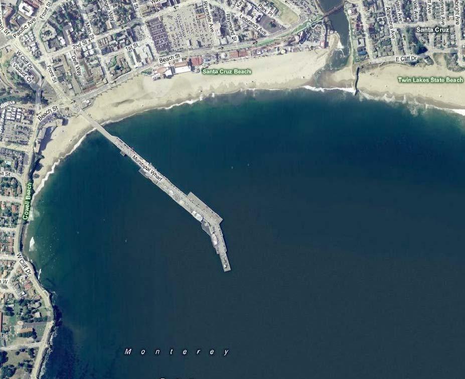
121
122
123
124
125 Section 7: Engineered Infiltration Gallery This section presents a discussion and evaluation of an offshore engineered infiltration gallery sub-seafloor intake alternative located in the offshore alluvial channel of the San Lorenzo River. Section 3 provides a general discussion of the engineered infiltration gallery sub-seafloor intake technology. An offshore engineered infiltration gallery system could be constructed in the offshore alluvial basin, off the San Lorenzo River, out near the end of the Santa Cruz Municipal Wharf. This approach would consist of dredging a large area of the alluvial material to a depth of approximately 10 to 12 feet to form a gallery. Collector piping and engineered gravel and sand would be placed in the gallery. Seawater would primarily move vertically down through the engineered gravel and sand to the perforated collector piping and then into the central collector. The collector would be connected to an onshore pump station by an intake pipeline. Figures 7-1 and 7-2 (at the end of the section) show conceptual drawings of an offshore engineered infiltration gallery, intake pipeline and onshore pump station near the Santa Cruz Municipal Wharf. The figures show the conceptual layout of the engineered infiltration gallery and illustrate how they would be connected to an onshore pump station. To minimize visual and aesthetic impacts, the onshore facilities could be constructed primarily below grade. The engineered gallery is shown in an approximate location to the east of the Santa Cruz Municipal Wharf although it could also be located to the south of it within the alluvial channel. 7.1 Conceptual Design of an Engineered Infiltration Gallery Intake The offshore engineered infiltration gallery intake system would include the following major components: Engineered Infiltration Gallery to collect seawater through a constructed intake gallery below the seafloor. Offshore Intake Pipeline to conduct the water from the engineered infiltration gallery to the onshore pump station. Onshore Pump Station to pump the seawater to the desalination facility site. Transmission Pipeline onshore pipeline to conduct the seawater to the desalination facility site. This section provides conceptual design criteria for the major components of the intake system to permit evaluation and preparation of an opinion of conceptual construction cost for the system. scwd 2 Seawater Desalination Intake Technical Feasibility Study, scwd 2 Desalination Program Page 7-1
126 7.1.1 Engineered Infiltration Gallery Design Criteria The engineered infiltration gallery would be constructed by dredging the existing sediment from the ocean floor using standard ocean-dredging equipment and replacing the sediment with engineered gravel and sand. The infiltration gallery collector piping would be perforated HDPE pipe constructed as a manifold with perforated branch piping. It would be installed at the bottom of the dredged pit. A collector box would join the infiltration gallery with the HDPE intake pipe. The collector box would be lowered from a barge into the dredged pit and connected to the perforated piping, and to the HDPE intake pipeline. The intake pipe would have to be installed before the infiltration gallery is constructed to allow this connection to be made. The engineered media would then be placed on top of the perforated piping by barge and divers. The location and potential production capacity of the engineered infiltration gallery are controlled by the impacts to the gallery from wave energy and the mobile sediment layer in the offshore area, described below. The gallery should also be constructed in seafloor alluvial sediments as opposed to bedrock. The bedrock areas offshore are habitats for kelp, marine invertebrates and fish. Blasting out a gallery from the bedrock would be significantly more disruptive than dredging of lower productivity sandy seafloor areas Wave Energy and Storm Flow Impacts on an Engineered Infiltration Gallery Section 4 describes the impacts of wave and storm flows on the seafloor off the Santa Cruz coastline. Because wave energy could dig up an engineered infiltration gallery in the near-shore area, depending on where the waves are breaking and the orbital energy levels from the waves at the seafloor, an engineered infiltration gallery would need to be located farther offshore in deeper water. In the area near the Santa Cruz Municipal Wharf, Point Santa Cruz helps to protect this area from the predominant ocean wave energy. USGS data indicate that in the area of the offshore alluvial channel, approximately 3,000 ft offshore and approximately 30 to 40 ft depth, the typical wave energy does not cause significant erosion of the seafloor. Therefore, an engineered infiltration gallery would need to be placed at least 3,000 feet offshore (past the end of the wharf) to protect the engineered media from being scoured out by typical storm waves Sediment Impacts on an Engineered Infiltration Gallery Section 4 also describes a mobile sediment layer of fine sand and silt that that deposits and erodes over the course of the year in the area of the offshore alluvial channel. USGS has measured the mobile sediment thickness approximately 3,000 ft offshore in the vicinity of the potential infiltration gallery to be as deep as 1 to 3 feet. The sediments in the mobile sediment layer range in size from very fine silt to medium sand, with silt and clay making up 10% to 40% of the total. The grain size typically decreases with increasing distance from shore and greater depth. As the wave energy decreases, the finer sands and silts settle onto the seafloor. In addition to the vibracore samples, a sample of the mobile sediment in the area near a potential location of an infiltration gallery was obtained, characterized, and analyzed for grain size and permeability. The grain size in the sample ranged from approximately 0.4 mm to less than 0.01 mm, with a 50-percentile size of approximately 0.1 mm. The measured hydraulic conductivity from this sample was 3.3x10⁻⁴ cm/sec. This sediment sample datum is consistent with data from the vibracore samples (ECO-M, 2010) and data presented in the USGS sediment studies (Storlazzi, 2010). Page 7-2 scwd 2 Seawater Desalination Intake Technical Feasibility Study, scwd 2 Desalination Program
127 It is expected that this mobile sediment layer would quickly cover the coarse grain sands of an engineered infiltration gallery. The fine sediments would also be drawn down into the coarsegrained engineered media as the seawater is drawn through the gallery. The impact of this mobile sediment layer on the operation of the engineered infiltration gallery would be to restrict flow through the gallery. The potential water production from an engineered infiltration gallery was modeled based on the sediment characteristics, size, and permeability information from the Offshore Geophysical Study and the additional mobile sediment sample. Because the finegrained sediments would cover the engineered gallery, the water flow through the top level of mobile sediment layer would control the flow through the infiltration gallery. The characteristics of this fine layer of sediment therefore would dictate the area required for the infiltration gallery to meet the required flow rate. To produce 6.3 mgd of seawater for the 2.5 mgd desalination facility, the offshore engineered infiltration gallery would need to be approximately 265,000 ft 2. This area is equivalent to about four-and-a-half (4.5) football fields. The infiltration gallery would be approximately 725 ft long and 365 ft wide and would be dredged to a depth of approximately 10 ft. Almost 100,000 cubic yards (CY) of sediment would need to be dredged and disposed of, and 100,000 CY of gravel and sand deposited in the engineered gallery. Table 7-1 presents the conceptual design criteria for an engineered infiltration gallery. Table 7-1: Conceptual Design Criteria for Engineered Infiltration Gallery Design Parameter Unit Initial Value Future Value Plant Water Production Rate MGD/gpm 2.5/1, /3,100 Maximum Intake Flow Rate MGD/gpm 6.3/4, /7,850 Infiltration Gallery Approximate Depth at Gallery Location ft Infiltration Rate gpm/ft Approximate Gallery Area ft 2 265, ,000 Number of Galleries Gallery Dimensions (L x W x D), Each ft 725 x 365 x x 725 x 10 Volume of Dredged Material CY 100, ,000 Gallery Branch Collector Pipe Diameter inch Gallery Main Collector Pipe Diameter inch Engineered Media Crushed Rock Depth ft 4 4 Crushed Gravel Depth ft 1 1 Sand Media Depth ft 5 5 Sand Media Effective Size mm Approx. Head loss through Engineered Media ft scwd 2 Seawater Desalination Intake Technical Feasibility Study, scwd 2 Desalination Program Page 7-3
128 7.1.2 Offshore Intake Pipeline A single offshore intake pipeline would connect the engineered infiltration gallery with an onshore pump station. The single pipeline is appropriate because the sub-seafloor intake helps to minimize bio-growth on the inside of the pipeline. The intake pipeline would be a 36-inchdiameter HDPE pipe, which could be installed by HDD. The drilling of the intake pipeline in the area near the Santa Cruz Beach Boardwalk would be challenging. The HDD drilling equipment could be set up on Westbrook Street near the intersection of First Street. The drilling would begin at the ground surface at an angle of about 15 degrees from horizontal and would continue at that angle until the borehole reached the depth of the pump station wet well. The drilling trajectory would then gradually become horizontal, proceeding beneath the ocean bed at depths of more than 30 ft below the seafloor surface to the target elevation of the infiltration gallery. The 36-inch-diameter pipeline would be pulled back into the borehole as far as the location of the pump station. The remaining borehole between the drilling rig and the pump station would be filled with grout and abandoned. Where the pipeline crosses the railroad tracks near the beginning of the Santa Cruz Municipal Wharf, it would be necessary to install a steel casing below the tracks to meet the requirements of Union Pacific Railroad. The recommended alignment for the intake pipeline avoids the foundations of the Santa Cruz Beach Boardwalk buildings and enables work to take place in city streets. The intake pump station could be located along Beach Street near an existing beach vehicle access ramp, across from the volleyball area. If the engineered infiltration gallery were to be located to the south or west of the Santa Cruz Municipal Wharf, the HDD drilling could be conducted as described in Section 6 for the radial collector well alternative. Table 7-2 contains conceptual design criteria for the pipeline. Table 7-2: Conceptual Design Criteria for HDPE Intake Pipeline Design Parameter Unit Initial Value Future Value Maximum Intake Flow rate MGD/gpm 6.3/4, /7,850 Intake Pipeline Outside Diameter of New Pipe inches Inside Diameter of New Pipe inches Dimension Ratio DR Approximate Pipeline Length ft 3,000 3,000 Maximum Velocity fps Head Loss with C=120 ft 2 6 Pump Station Bottom of Wet Well Elevation ft Head loss calculated using Hazen-Williams equation. Page 7-4 scwd 2 Seawater Desalination Intake Technical Feasibility Study, scwd 2 Desalination Program
129 7.1.3 Onshore Intake Pump Station A new intake pump station could be constructed on the beach adjacent to the pedestrian walkway located where Westbrook Street intersects Beach Street. It would house three vertical turbine pumps and associated electrical equipment. A preliminary estimate of the building footprint is 40 ft x 30 ft. To compensate for low tide, head loss through the infiltration gallery and intake pipeline, and required submergence for pump suction, the bottom of the wet well would need to be approximately 30 ft below mean tide level. The pump station would include a wet well with a pump room above. Access hatches above the pumps would be located to allow removal of the pumps for periodic maintenance. An electrical room would be located next to the pump room. The pump station could be constructed as a low-profile structure with much of the equipment below ground level. Showers and/or bathrooms could be incorporated as part of the building to provide additional public services at the beach. Lifeguard towers currently stored in this location during the off season would need to be stored elsewhere if the pump station is built in this location. Table 7-3 gives conceptual design criteria for the pump station. Table 7-3: Conceptual Design Criteria for Engineered Infiltration Gallery Pump Station Design Parameter Unit Value Approximate Bottom of Wet Well Elevation ft -30 Approximate Pump Station Footprint Dimensions ft x ft 40 x 30 Pump Station Capacity MGD/ gpm 6.3/4,400 Pump Type - Vertical Turbine Number of Pumps # 3 Space for Future Pumps # 1 Pump Capacity (Each) gpm 2,200 Approximate Pump Total Dynamic Head ft 90 o Suction Head ft 20 o Static Head ft 40 o Dynamic Head ft 30 Speed Control - VFD Pump Material - Super Duplex SS scwd 2 Seawater Desalination Intake Technical Feasibility Study, scwd 2 Desalination Program Page 7-5
130 7.1.4 Plant Influent Seawater Transmission Pipeline The plant influent pipeline for this alternative would be the same as that described in Section 6. Assuming 2 miles of pipeline installed at a unit price of $500 per linear foot, the seawater transmission pipeline would cost approximately $5.3 million. 7.2 Environmental Impact Mitigation This report recognizes that there will be different construction and operational environmental impacts for the different approaches and types of sub-seafloor and open-ocean, screened intakes that are described herein. General environmental impacts of intake systems are described in Section 2. The project EIR will consider those intake system alternatives that are determined to be technically feasible or potentially feasible, and evaluate the environmental impacts of the intake systems. Potential environmental mitigation for the construction and operation of the intake systems, as well as for other aspects of the project, will be developed in the EIR and subsequent phases of the scwd 2 Desalination Program. 7.3 Conceptual-Level Opinion of Probable Costs Conceptual Construction Costs Table 7-4 presents the conceptual-level opinion of construction cost for the engineered infiltration gallery alternative, including transmission piping costs. The basis for the development of the conceptual level opinion of costs is presented in Section 12 of the report. Table 7-4: Engineered Infiltration Gallery Intake Conceptual Construction Cost Intake Component Conceptual Cost Engineered Infiltration Gallery $21,500,000 Intake Pipeline $7,200,000 Intake Pump Station $3,600,000 Transmission Piping to Facility $5,300,000 Total Construction Cost $37,600, Conceptual-Level Operating Costs Conceptual-level operating and maintenance costs associated with engineered infiltration gallery include, dredging and replacing engineered gallery fill and regular maintenance of the pump station and ancillary equipment. Table 7-5 summarizes the conceptual level operating cost Infiltration Gallery and Pipeline The operation and maintenance of the infiltration gallery would include inspecting the top layers of the engineered fill annually to determine if the sand layer has shifted or if excessive silt has accumulated. The level of maintenance required would primarily depend on the impact of wave Page 7-6 scwd 2 Seawater Desalination Intake Technical Feasibility Study, scwd 2 Desalination Program
131 energy and mobile sediments on the infiltration gallery. If the engineered sand layer becomes significantly scoured, new sand would need to be imported and placed. If the hydraulic conductivity through the top layer of the infiltration gallery is reduced below the design rate, the top layer of silt and sand could have to be dredged out and replaced. The operations cost opinion assumes dredging and replacement of the top 2 ft of media (approximately 40,000 CY) every 2 years at an estimated cost of $4 million. The cost presented below assumes that an annual budget would be allocated for periodic maintenance. The pipeline between the radial well and the onshore pump station would require little maintenance. The pipeline is not expected to have significant bio-growth; therefore only a single pipeline would be required. Periodic inspection could be conducted with remote video equipment Intake Pump Station The operation and maintenance of the pump station would be similar to that described in Section 6 for the radial collector well intake. Estimated maintenance costs to maintain the pumps, piping, and appurtenances in proper operating condition are based on labor requirements for inspections and repairs and the cost of pump repair kits and replacement materials. Energy costs were estimated with the assumption that seawater would be pumped to a height of 40 ft above sea level, with approximately 20 ft of suction lift, and 30 ft of head loss through a 2-mile-long pipeline to the desalination facility (total head of approximately 90 ft). This would require approximately 0.4 kilowatt-hours (kwh) of energy for every 1,000 gallons of water pumped (kgal) (0.4 kwh/kgal). The type of intake system will likely have an impact on the amount of pretreatment that is required. The source water from a sub-seafloor intake would have lower suspended solids than a screened open-ocean intake; however, based on the geotechnical data, it would likely have iron and manganese that would need to be removed through a pretreatment step. Iron and manganese pretreatment could be achieved through a pressure sand filter system. This pretreatment could add approximately 0.5 to 1 kwhr/kgal of energy use to this alternative. The energy use is therefore estimated at 1.4 kwhr/kgal. Energy costs were estimated at $0.16 per kwh. scwd 2 Seawater Desalination Intake Technical Feasibility Study, scwd 2 Desalination Program Page 7-7
132 Table 7-5: Infiltration Gallery Conceptual Operating Cost Intake Component Conceptual Annual Cost Annual Gallery and Pipeline Inspections $10,000 2 feet of Dredging and Media Replacement Every 2 years (Amortized $2,000,000 Annual Cost) Pump Station Cleaning (Every 6 months) $20,000 Pump Station Maintenance $20,000 Energy $125,000 Total Operations Cost $2,175, Summary Evaluation of an Engineered Infiltration Gallery An engineered infiltration gallery sub-seafloor intake in the offshore alluvial channel of the San Lorenzo River is not technically feasible. The fine silts in the mobile sediment layer are likely to plug the gallery relatively quickly and a large storm event could potentially dig-up the engineered media. Because of the relatively high energy coastline and the fine mobile sediment layer, there would be significant costs and risks associated with this alternative Advantages and Disadvantages The relative advantages of the engineered infiltration gallery sub-seafloor intake in the offshore alluvial channel of the San Lorenzo River include: Proven passive protection of marine organisms from entrapment, impingement and entrainment. Sub-seafloor intake reduces the bio-fouling on the seawater transmission piping and facilities. Sub-seafloor intake reduces the suspended solids that need to be filtered out at the desalination facility. This may permit a less robust pretreatment ahead of the RO process. The relative disadvantages of the engineered infiltration gallery sub-seafloor intake in the offshore alluvial channel of the San Lorenzo River include: There is significant risk associated with this approach because of the relatively high energy coastline location. The gallery could be dug-up in a large storm. This would be a fatal flaw. The only operational infiltration gallery (Fukuoka, Japan) is in a more protected location with minimal mobile sediment. The fine mobile sediments would likely be drawn into the pores in the engineered media as seawater moves through the gallery. The fine sediments could plug up the gallery and require relatively frequent media dredging and replacement. The operational costs could Page 7-8 scwd 2 Seawater Desalination Intake Technical Feasibility Study, scwd 2 Desalination Program
133 increase significantly and the production of the plant could be severely impacted. This would be a fatal flaw. The fine silts could be drawn through the gallery filter and could require filtration pretreatment ahead of the desalination process. Expansion of the offshore infiltration gallery intake system would be limited due to the area of the offshore alluvial channel. scwd 2 Seawater Desalination Intake Technical Feasibility Study, scwd 2 Desalination Program Page 7-9
134
135
136
137
138
139 Section 8: Overview of Screened Open-Ocean Intake Systems This section provides an overview of intake technologies that draw seawater from the open ocean environment and how the different types of intake technologies minimize environmental impacts described in Section 2. The section also provides examples of operating intake systems using the technology and relative advantages and disadvantages of the different intake approaches. The primary purpose of a seawater intake system is to withdraw a desired amount of seawater from the ocean while protecting and minimizing mortality of the marine organisms in the ocean environment. Screened, open ocean intake technologies that offer proven entrapment, impingement and entrainment protection to early life stages of marine life include: Velocity cap and fine-mesh traveling water screens Narrow-slot wedgewire screens Aquatic filter barriers Other available fish protection technologies, such as coarse-mesh screens (traveling water screens, large-slot cylindrical wedgewire screens, and barrier nets), diversion systems (angled bar racks, louvers, and inclined plane screens), and behavioral barriers (sound, light, and air bubbles) are limited in their potential for use and were not evaluated further because they are designed to prevent entrapment and/or impingement mortality only and not entrainment. 8.1 Velocity Cap and Fine-Mesh Traveling Water Screens A velocity cap is a structure that is placed out in the ocean and that is used to achieve a low intake approach velocity to prevent impingement and minimize entrainment. Figure 8-1 shows a graphic of a typical velocity cap. Figure 8-2 shows a velocity cap structure during the construction of the Perth Desalination Facility. The velocity cap spreads out the area through which the water is being withdrawn to reduce the intake approach velocity. However, the velocity cap does not have narrow screen slots that would prevent entrapment of small marine organisms or help to minimize entrainment. The slot size for a velocity cap may be several inches wide and is designed to prevent large organisms from entering the intake system. scwd 2 Seawater Desalination Intake Technical Feasibility Study, scwd 2 Desalination Program Page 8-1


140 Figure 8-1: Velocity Cap at the Terminus of an intake Pipe Figure 8-2: Velocity Cap for the 38 MGD Perth Australia Seawater Desalination Facility To address entrapment of marine organisms, an onshore fine-mesh traveling water screen system would be used with velocity caps. The fine mesh screens would typically have mesh sizes of 0.5 mm and would be designed to operate at through-screen velocities of 0.5 fps. The fine-mesh traveling water screens would require the installation of an active fish capture and return system for the organisms that become entrapped in the onshore facility or impinged on Page 8-2 scwd 2 Seawater Desalination Intake Technical Feasibility Study, scwd 2 Desalination Program

141 the traveling water screen. Figure 8-3 shows a schematic of a typical fine-mesh traveling water screen. Figure 8-3: Fine-mesh Traveling Water Screen Many of the seawater desalination facilities operating, and under construction, in Australia have used the velocity cap and fine mesh traveling screen intake approach. In Australia, the velocity caps have typically been connected to the onshore screening facilities by a large diameter intake tunnel. The velocity cap slot size and the intake tunnel diameter have been sized to permit an accumulation of marine growth over time. The desalination facilities are periodically shut down to permit inactivation and removal of excessive biogrowth in the intake system General Advantages and Disadvantages The general advantages of the velocity cap and fine mesh traveling screen intake technology compared to other open ocean intake systems include: Reliable, proven intake technology that can provide large volumes of water. Proven protection of marine organisms from impingement, and use of active return system for protection from entrapment. Low intake velocity minimizes entrainment. scwd 2 Seawater Desalination Intake Technical Feasibility Study, scwd 2 Desalination Program Page 8-3
142 Screen facilities are onshore for easier access and maintenance. The general disadvantages of the velocity cap and fine mesh traveling screen intake technology include: Active fish return system is less effective than a passive system at protecting marine life due to the handling of the fish. Velocity cap slot size does not aid in minimizing entrainment of marine organisms. Requires more extensive onshore facilities right near the beach or shoreline. The use of the single cap and intake pipeline requires system shutdown for periodic maintenance of the intake system. 8.2 Narrow-slot Cylindrical Wedgewire Screens Narrow-slot cylindrical wedgewire screens are a passive protection technology designed to prevent entrapment and impingement of marine organisms, and minimize entrainment, by preventing passage of organisms into the intake system. Typically, multiple intake screens would be attached to a pipeline that runs to an onshore pump station. In some cases, multiple pipelines are also installed to connect the screens to the onshore pump station, to provide redundancy and the ability for uninterrupted operation during maintenance and cleaning. Redundancy in an intake system ensures that marine organisms remain adequately protected from entrapment, impingement and entrainment, and that the desalination plant is able to receive an uninterrupted supply of seawater if a screen malfunction occurs. Water would flow by gravity through the intake screen with a low approach velocity, as described in Section 2, to the pump station. Pumps then lift the water and pump it to the desalination facility. Narrow-slot cylindrical wedgewire screens are an approved and commonly used fish protection technology for freshwater rivers and estuarine bays. A graphic rendering of narrow-slot cylindrical wedgewire screens in an offshore marine environment is shown in Figure 8-4. Page 8-4 scwd 2 Seawater Desalination Intake Technical Feasibility Study, scwd 2 Desalination Program
 8.2.1 Screen Cleaning and Maintenance Because the screens are located out in the ocean instead of an onshore facility, maintenance and cleaning of the screens is an important consideration.")
143 Figure 8-4: Rendering of an Offshore Cylindrical Wedgewire Screen Intake System (Tenera, 2010) Screen Cleaning and Maintenance Because the screens are located out in the ocean instead of an onshore facility, maintenance and cleaning of the screens is an important consideration. Cleaning and maintenance of narrowslot wedgewire screens could be accomplished by: natural cleaning from ocean currents; airburst cleaning; manual cleaning; and use of biofouling resistant screen materials. The wedgewire design of the screen face and bars prevents sand particles or other debris from getting lodged in and plugging the screen. Local currents and wave induced water motion around the fixed screen should be sufficient to create sweeping velocities to transport debris and organisms off and away from the screens (Tenera, 2010). The local current velocities range from 0.3 to 1 fps and greater and wave motion would be approximately 10 times greater than the approach velocity of the water entering the screen. Fixed structures around the screened intake, like piles, could also be used to focus and enhance the natural movement of currents and wave action over the intake screen surface. Testing during the Open Ocean Intake Effects Study, described in Section 9, confirmed that local currents and wave action would prevent kelp and other debris from fouling and plugging a screened intake. Wedgewire screens can also be designed with an air backwash cleaning system to periodically clean the screen face of accumulated debris and biofouling. The release of air from a pipe on the inside of the screen creates a scouring action on the screen as it rises and passes through the narrow slots. The air compressor and requisite controls for an airburst system are typically located onshore and air piping is connected to each wedgewire screen. The use of an airburst cleaning on screened intakes would not be appropriate for Santa Cruz offshore locations. The airburst could create a navigational or recreational hazard to small boaters or surfers due to the change in buoyancy of the water above the screens during the airburst. Therefore, offshore screens would be cleaned and maintained without an airburst system scwd 2 Seawater Desalination Intake Technical Feasibility Study, scwd 2 Desalination Program Page 8-5
144 Offshore wedgewire screen systems are often manually inspected and cleaned by divers working from a barge or boat. Divers use brushes or water jets to periodically remove fouling from the screens while they are in the water and even in operation. Depending on the size of the screens, individual screens could also be removed for cleaning and inspection onshore and a new screen installed to maintain operations Screen Material and Biofouling Biofouling of intake screens in the marine environment is another important consideration. Past studies have been conducted to determine the propensity of different screen materials to foul. A study was conducted to compare fouling rates for several small wedgewire screens in Galveston Bay, Texas (Wiersema et al., 1979). The test screens were 9.5 inches in diameter with 2.0-mm slot openings. The screen material varied; one was stainless steel, two were copper-nickel alloys (CDA 706 and CDA 715), and one was a silicon-bronze-manganese alloy (CDA 655). The total duration of the test was 145 days. The salinity in Galveston Bay ranges from 20,000 to 30,000 mg/l. The results indicated that the copper-nickel alloys significantly reduced biofouling of the screens. The stainless steel screen fouled quickly and was completely clogged after 2 weeks. In general, the progression of biofouling agents was similar for all screens. First, a slime layer formed over the screens which trapped sediments and provided a base for further colonization. After about 4 weeks, hydroids began to colonize the screens. The hydroids were the dominant biofouling organism until tube-building amphipods appeared. The amphipods were only able to establish themselves on the portions of the screen with substantial hydroid cover. Throughout the test period, there was a small amount of colonization by bryozoans and loosely attached barnacles (Wiersema et al., 1979). Another biofouling study was conducted in 1983 on the Patuxent River in Maryland where the salinity ranges from 5,000 to 18,000 mg/l (Weisberg et al., 1986). This study evaluated a copper-nickel alloy, organotin coatings, and an air backwash to prevent biofouling on wedgewire screens. Biofouling on the copper-nickel screens was similar to that of stainless steel; however, the fouling biota was less firmly attached than on the stainless steel screens. Biofouling on the organotin-coated was significantly less than on uncoated panels. Based on this study, an organotin coating would be the best biofouling control. Unfortunately, the use of this family of chemicals is very detrimental to the environment and is severely restricted by the Organotin Antifouling Paint Control Act of 1988 (OAPCA, 1988). Additionally, applying a coating to a narrow slot mesh would result in a significant and unknown reduction in the open area of the screens. The Marin Municipal Water District (MMWD) Seawater Desalination Pilot Program included an evaluation of corrosion and biofouling of a narrow-slot cylindrical wedgewire open intake screen. The intake system at the pilot plant was in operation for over a year, from May 2005 through June The average salinity of the bay water ranged from 11,000 to 24,000 mg/l. Figure 8-5 shows a picture of the MMWD pilot intake screen. The intake screen was a cylindrical wedgewire screen. The screen material was a copper-nickel alloy and the other parts of the intake were 316 SS. The screen was equipped for air-burst self- Page 8-6 scwd 2 Seawater Desalination Intake Technical Feasibility Study, scwd 2 Desalination Program

145 cleaning. The screen slot width was 3/32 inches (2.4 mm) and the approach velocity at 150 gpm was approximately 0.24 fps (below the pilot permitted maximum limit of 0.33 fps). The intake screen was air-burst-cleaned in the water once per week and raised, inspected, and manually cleaned approximately every 4 to 6 weeks over the course of the pilot program. The reddish orange section in Figure 8-5 is made of copper-nickel alloy. The copper-nickel material worked well in preventing bio-growth. There was a thin slime layer that covered the copper-nickel screen which appeared to be easily removed by periodic air-burst-cleaning and by periodic manual washing. Sacrificial zinc anodes were attached to the screen and the coppernickel and stainless steel components appeared to resist corrosion well. Figure 8-5: Marin Municipal Water District (MMWD) Seawater Desalination Pilot Program Intake Screen after Manual Cleaning There was moderate marine growth on the stainless steel portions of the screen during the summer months and less growth during the winter months. The barnacles, marine plants, and other organisms on the non-copper-nickel materials of the screen were removed by moderate manual scraping with a metal scraper and washing. The stainless steel held up well in terms of corrosion. Sacrificial zinc anodes were attached to the intake to protect the stainless steel components. During the pilot evaluation, the intake was left in operation for three months without airburst or manual cleaning. Figure 8-6 shows the intake after approximately three months without cleaning. There is significant bio-growth on the non-copper components. scwd 2 Seawater Desalination Intake Technical Feasibility Study, scwd 2 Desalination Program Page 8-7

146 Figure 8-6 : Marin Municipal Water District (MMWD) Seawater Desalination Pilot Program Intake after Three Months with No Cleaning from April to June 2006 The intake screen worked well in terms of producing the required flow rates even when it was covered in significant marine growth. The screen section is marked by the red arrow in the figure. Although the stainless steel and plastic components had significant marine growth, the copper-nickel screen was not appreciably fouled. Based on the previous studies and pilot testing, the recommended screen material is a coppernickel alloy. The Intake Effects Study, conducted for the screened open ocean intake approach and summarized in Section 5, includes a discussion of a corrosion and biofouling evaluation of a copper-nickel wedgewire screen General Advantages and Disadvantages The general advantages of the passive narrow-slot wedgewire screen intake technology compared to other open ocean intake systems include: Reliable, proven intake technology that can provide large volumes of water. Proven passive protection of marine organisms from entrapment and impingement. Narrow slot size and low intake velocity minimizes entrainment. Onshore facilities are smaller than for the velocity cap approach. Page 8-8 scwd 2 Seawater Desalination Intake Technical Feasibility Study, scwd 2 Desalination Program
147 Multiple screens can be used to provide redundancy and maintain operations during system maintenance. The general disadvantages of the passive narrow-slot wedgewire screen intake technology compared with the other open ocean screen intake technologies include: The narrow slot screens require more frequent cleaning than velocity cap intakes. Maintenance requires a boat and divers for periodic cleaning operations. 8.3 Wedgewire Screen Intakes in Monterey Bay, California To provide additional insights into the reliability, conceptual design and operations of a screened open-ocean intake for the scwd 2 Desalination Program, two intakes systems currently operating in the Monterey Bay were investigated. One intake is located in the southern part of Monterey Bay (South MB Intake) and the other is located in the northern part of the Monterey Bay (North MB Intake). The design and operation of these intake systems are summarized below. Table 8-1: Summary of Existing Intake Designs and Operations Intake Parameter South MB Intake North MB Intake Intake Flow Rate 2,000 gallons per minute (gpm) 1,000 gpm Intake Type Screen Type Gravity Flow to Onshore Pump Station Dual Screens, Large Mesh, Velocity Cap Type Gravity Flow to Onshore Pump Station Dual Screens, Narrow-lot Wedgewire Screen Material 316L Stainless Steel 316L Stainless Steel Pipeline Type and Material Dual HDPE Pipelines Dual HDPE Pipelines Pipeline Diameter and Length 16 inches, ~1,400 feet (ft) 10 inches, ~100 ft Intake Pipeline Flow Velocity 3.1 feet per second (fps) 3.2 fps Screen Cleaning Approach Divers Remove Screen and Manually Clean Divers Remove Screen and Manually Clean Screen Cleaning Frequency 6 to 8 weeks 8 weeks Pipeline Cleaning Frequency 6 to 8 weeks 16 weeks scwd 2 Seawater Desalination Intake Technical Feasibility Study, scwd 2 Desalination Program Page 8-9
148 8.3.1 South Monterey Bay Intake System The South MB intake system supplies up to 2,000 gpm (2.8 MGD) of seawater to a facility located at the southern end of the Monterey Bay. This system is critical to the facility operations and its design and operations and maintenance procedures have been developed over the years to provide a high level of reliability. The intake system, constructed in the early 1980s, has two parallel, 16-inch-diameter, high density polyethylene (HDPE) pipelines that are laid on the seafloor and held in place by concrete anchors. Each intake pipeline has a screen at the intake end. This end is approximately 50 ft deep and is anchored to bedrock. To permit some flexibility for movement in large storms, the dual pipelines were laid in a serpentine pattern out from the shore. The seawater flows by gravity through the pipe to the wet well of a pump station onshore. The South MB intake system uses the dual pipelines and intake screens to allow continued operation of one intake screen and pipeline while the other screen and pipeline are removed from service for cleaning. The design, operation, and maintenance of the South MB intake system revolve around controlling bio-growth on the screens and on the insides of the intake pipelines. Mussels and barnacles in the larval stages are small enough to pass through the intake screens, after which they attach to the insides of the intake pipelines. The seawater flowing past the mussels, barnacles, and other types of fixed marine life provides sufficient food and nutrients for the organisms to flourish and grow on the intake system. As they do, the head loss across the intake screen and in the pipeline increases and adversely reduces the volume of water entering the system. For control of the bio-growth and maintenance of system operations, one screen and pipeline are operated for a 6- to 8-week period until approximately 1/2 to 1 inch of bio-growth has accumulated on the inside of the pipeline. During that period, the other intake pipeline is isolated by valves. The bio-growth in the isolated pipeline does not receive nutrients and eventually dies. This pipe is easier to clean because the mussels and barnacles are now not as strongly attached to the pipe. A barge and divers remove the intake screen as part of the pipe cleaning process. A clean, spare screen is then installed and the fouled screen is taken ashore for cleaning; because the screen materials are 316 stainless steel, fouling occurs and they must be cleaned as often as the pipelines. After the isolated intake pipeline has been cleaned, it is put into service and the other pipeline is isolated North MB Intake System The North MB intake system typically supplies up to 1,000 gpm of seawater to a facility located at the northern end of the Monterey Bay. The intake system is critical to the facility operations, and its design, operation, and maintenance procedures also have been developed to provide a high level of reliability for this system. Page 8-10 scwd 2 Seawater Desalination Intake Technical Feasibility Study, scwd 2 Desalination Program
149 The North MB has two separate intake systems. The first intake, constructed in 1975, has narrow-slot cylindrical wedgewire screens that are located at the shoreline, at the base of a rock outcropping, and submerged approximately 3 to 5 ft below the surface. The screens are connected to an onshore caisson pump station with parallel intake pipes. Because of this intake location, the screens can accumulate sand and the kelp debris that drifts into the cove around the screens. Divers must periodically clean debris away from the intake screens. The second intake system was constructed in 2002 to provide additional reliability for North MB intake operations. The second intake has a single bar screen intake located just below mean low sea-level at the base of a different rock outcropping. The second intake was located in a higher-wave-energy area to minimize the impacts from sand and kelp debris accumulation; however, sediments tend to accumulate in the caisson from this higher-energy location and must be periodically removed. Narrow-slot wedge wire screens are placed around the pumps inside the caisson system to minimize marine organisms being drawn into the system. Like the South MB intake system, the North MB intake system features design, operation, and maintenance that revolves around controlling bio-growth on the screens and on the insides of the intake pipelines. The North MB staff typically operates one intake system while the other is being cleaned or maintained. The screens are cleaned approximately every 8 weeks and the pipelines to the pump caissons are cleaned approximately every 16 weeks less frequently than the MBA pipeline cleaning. This could be because there are fewer nutrients in the northern part of Monterey Bay near the North MB intake than in the southern part of Monterey Bay. These conditions indicate that a screened Open-Ocean intake for the scwd 2 desalination facility would require a cleaning frequency like that of the North MB intake. The information from these operating intake systems was used to estimate the O&M costs for a proposed screened openwater intake for the scwd 2 Desalination Facility. 8.4 Aquatic Filter Barrier An Aquatic Filter Barrier (AFB) can be thought of as a very fine meshed cloth netting material that is placed in the water around an intake system to prevent marine life from entering the intake. The AFB material would be anchored to the seafloor and suspended by floats to reach from the seafloor to the surface. The mesh size of the AFB material can be on the order of 0.05 mm. Because the mesh size is so small, the area of the AFB must be relatively very large to permit the water to flow through the screening material. Figure 8-7 shows an AFB installation on the Hudson River in New York. scwd 2 Seawater Desalination Intake Technical Feasibility Study, scwd 2 Desalination Program Page 8-11
150 Figure 8-7: An Aquatic Filter Barrier Screen Although the AFB has proven effective in reducing the entrainment of early life stages of fish at some freshwater intakes in lakes and reservoirs, there are significant engineering challenges associated with its use in an ocean environment. Deployment and maintenance of AFB has been shown to be difficult. Application of this fish protection technology has been limited to two freshwater installations on the Hudson River in New York and a brackish surface water desalination facility on the Taunton River in Massachusetts. At the New York sites, the AFB has undergone significant failures due to ambient hydraulic and hydrodynamic forces, excessive debris loading, and ineffective backwashing (LMS, 1996; 1997). In Massachusetts, the AFB has worked relatively well in the low current tidal river, but must be removed each winter to prevent damage from ice. Furthermore, there are no instances in which AFB has been used in a marine environment and it is expected that currents in the ocean pose potentially insurmountable design obstacles for this technology. Therefore, this technology was not considered further. 8.5 Initial Evaluation of Screened Open-Ocean Intake Technology The passive narrow slot wedgewire screen technology is the recommended technology for a screened, open ocean intake approach for the scwd 2 Desalination Program. The passive marine protection technology provides the following advantages: Reliable, proven intake technology that can provide the initial 6.3 mgd of intake water and could be easily expanded in the future if needed. Proven passive protection of marine organisms from entrapment and impingement. Narrow slot size and low intake velocity minimizes entrainment. Onshore facilities are smaller than for the velocity cap approach and can be integrated into existing structures or constructed below ground to minimize aesthetic impacts. Page 8-12 scwd 2 Seawater Desalination Intake Technical Feasibility Study, scwd 2 Desalination Program
151 Multiple screens can be used to provide redundancy and maintain operations during system maintenance. Based on the expected species in the area of the intake and the EPA and NMFS approved freshwater intake system screen slot size and approach velocity requirements, Kennedy/Jenks recommended further testing and evaluation of a copper-nickel, narrow-slot wedgewire screen technology with a 2 mm screen slot size and with an approach velocity of less than 0.33 fps. The results of the intake screen testing are described in Section 9. Sections 10 and 11 present a more detailed discussion of screened, open-ocean intake alternatives for the scwd 2 Desalination Program. On the basis of review of the operation and maintenance of the existing Monterey Bay intake systems, Kennedy/Jenks recommended evaluation of a dual-intake pipeline design and operation approach for the screened open-ocean intake alternative. This approach would provide redundancy and bio-growth control and would facilitate maintenance and cleaning. The dual-intake system could entail either rehabilitation of an existing pipeline along with installation of a new pipeline or installation of two new pipelines. Without dual-intake pipelines, an open ocean screened intake would likely need to be shutdown approximately every 4 months (once per quarter) for control of mussel/barnacle growth in the pipeline. The shutdowns could last for approximately 4 days or up to a week or more depending on the method of control of mussel/barnacle growth. If feed water is not available to the desalination plant, treatment activities would need to be shutdown. To provide relatively stable and continuous desalination treatment plant operations and water production, as would be desired during drought conditions, a seawater storage reservoir could be used to store seawater while the intake pipeline is being cleared of mussels/barnacle growth. However, the size of reservoir required (from approximately 12 million gallons to 24 million gallons or more) would have significant cost and challenges locating the space for such storage, as well as operational challenges in maintaining such a large seawater storage system that would be prone to biofouling. Another approach for using a single intake pipeline could be to increase the size of the pipeline to permit longer periods of operation between the required cleaning events. The desalination facility could be operated at a higher production rates for the period in between cleanings, such that the overall average production rate over the quarter or say a 6 month period provides the required supplemental water supply. This single intake pipeline approach would have lower reliability and would have more complicated operations and maintenance requirements than a dual-intake pipeline approach. Based on the experience at the two Monterey bay intakes and the advantages discussed above, the dual dual-intake pipeline approach is recommended for the scwd 2 Desalination Program. scwd 2 Seawater Desalination Intake Technical Feasibility Study, scwd 2 Desalination Program Page 8-13
152 8.6 Initial Evaluation of Screened Open-Ocean Intake Locations The initial evaluation of screened open-ocean intake locations yielded a recommendation for two sites after the consideration of the coastline with respect to multiple criteria. The potential locations of a passive narrow slot wedgewire screen intake system for the scwd 2 Desalination Program were evaluated with the following general screening criteria: The intake should be offshore away from biologically sensitive kelp forests or rocky seafloor habitat where marine life is more abundant. The intake should be placed deeper in the water column to minimize the entrainment of algae and phytoplankton that tend to be closer to the surface. The intake location should consider the location of the Santa Cruz wastewater treatment plant effluent discharge location and other areas where human activity can impact the quality of the ocean water source. The intake should take advantage of existing infrastructure on the seafloor or on the beach, if possible, to minimize new construction impacts. The intake location should consider the distance from the intake to the desalination facility location in west Santa Cruz, to minimize pipeline conveyance construction and the energy for pumping the seawater to the facility. The coastline from above Wilder Ranch State Park, east through of the City of Santa Cruz, and down to Capitola was evaluated for potential passive narrow slot wedgewire screen intake locations. Potential intake locations to the west of Santa Cruz and offshore of Wilder Ranch State Park, Terrace Point, and Natural Bridges State Beach were evaluated. However, at these locations, there are near-shore kelp beds and the offshore seafloor is primarily rocky bottom. The areas of sandy seafloor offshore of these locations are relatively far offshore and near to the discharge nozzles of the Santa Cruz wastewater treatment plant effluent discharge pipeline. Several of these areas are also California State Parks and there is not much existing infrastructure offshore or onshore. Because of the above disadvantages, these locations were not considered further. The PEIR identified using an abandoned pipeline extending out approximately 2,000 feet offshore of Mitchell s Cove as a location for a passive narrow slot wedgewire screen intake system. This location is close to the west side of Santa Cruz and would take advantage of existing infrastructure on the seafloor, and on the beach at Mitchell s Cove, for components of the intake system. There is a near-shore kelp forest that extends approximately 500 to 1,000 feet offshore, but the screens would be placed approximately 1,000 feet beyond the kelp zone. The screen location would be in relatively deep water (approximately 40 feet deep) and would be in a primarily sandy bottom area. Also, because the Santa Cruz wastewater treatment plant effluent discharge pipeline extends approximately 2 miles to the southeast from Mitchell s Cove, the intake is separated from the discharge nozzles of the pipeline. Water quality monitoring in conjunction with the desalination pilot study and the watershed sanitary survey for the project Page 8-14 scwd 2 Seawater Desalination Intake Technical Feasibility Study, scwd 2 Desalination Program
153 confirmed that the wastewater treatment plant effluent discharge would not impact this intake location. Another potential location for the passive narrow slot wedgewire screen intake system is near the end of the Santa Cruz Municipal Wharf. The seafloor in this area is sandy bottom and the intake screen location would be in relatively deep water (approximately 40 feet deep). Although two new pipelines would need to be constructed, there is existing infrastructure on the seafloor associated with the wharf, as well as onshore infrastructure that could support components of the pump station. The location could also have advantages for intake system access and maintenance. From a water quality standpoint, this location is farther from the Santa Cruz wastewater treatment plant effluent discharge pipeline but would see more sediments from the San Lorenzo River. Although this location is farther to the east and would have a longer supply pipeline, this location is recommended for further evaluation. A passive narrow slot wedgewire screen intake system could potentially be located in the lower basin of the Santa Cruz Small Craft Harbor. This could have advantages for intake system access and maintenance and lower costs for the intake pipelines. However, the intake screens would not be offshore in higher quality water and would be relatively shallow and more susceptible to drawing in algae. The water quality in the Small Craft Harbor would likely be lower quality than an offshore location and would require more treatment at the desalination facility. The Department of Public Health may not permit this location due to water quality concerns. This location is farther to the east and would have a longer supply pipeline to reach the desalination facility site. Due to the water quality disadvantages and the longer supply pipeline, this location was not considered further. Potential intake locations to the east of Santa Cruz and offshore of Twin Lakes State Beach, Soquel Point, and the Capitola area were evaluated. However, at these locations, there are near-shore kelp beds and the offshore seafloor is primarily rocky bottom similar to the seafloor to the west of Santa Cruz. The areas of sandy seafloor offshore of these locations are relatively far offshore. These locations are significantly farther to the east and would have a longer supply pipeline to reach the desalination facility site. Due to the rocky seafloor conditions and the longer supply pipeline, these locations were not considered further. The recommended locations for a passive narrow slot wedgewire screen intake system for the scwd 2 Desalination Program are on the westside of Santa Cruz near Mitchell s Cove and near the Santa Cruz Municipal Wharf. Sections 10 and 11 present more a more detailed discussion of the passive screened open-ocean intake alternatives. scwd 2 Seawater Desalination Intake Technical Feasibility Study, scwd 2 Desalination Program Page 8-15
154
155 Section 9: Summary of the scwd 2 Pilot Test of a Wedgewire Screened Intake in the Northern Monterey Bay This section provides an overview of the pilot test investigations of a passive, narrow-slot cylindrical wedgewire screen conducted by Tenera Environmental, for the scwd 2 Desalination Program. The study report is titled, Open Ocean Intake Effects Study, and dated December 2010 (Intake Effects Study, Tenera 2010). The objective of the intake screen pilot studies was to examine the following operational characteristics of the screened, open water intake system in situ: 1) larval entrainment, 2) impingement, 3) screen corrosion and biofouling of potential screen materials, and 4) a qualitative investigation of current dynamics around the screen during pumping. In Section 8, the results of previous studies of wedgewire screens used in other locations was reported. This section will cover the aspects of the pilot study that relate to the functionality of the narrow-slot wedgewire screen in the marine environment of the Monterey Bay. The results of the comparison of the screened and unscreened intake pilot system with regard to larval entrainment impacts are covered in depth in the Intake Effects Study. Sections 10 and 11 utilize the information obtained during the pilot test investigations for conceptual level design and evaluation of the operations and maintenance of the intake screens. The potential environmental impacts from the screened open water intake system will be evaluated in the project EIR. The Intake Effects Study was undertaken in consideration of the California State Water Code Section (d), which states that, independent baseline studies of the existing marine system should be conducted in the area that could be affected by a new or expanded industrial facility using seawater, in advance of the carrying out of the development. Regional Water Quality Control Board members and staff recommend that Federal CWA, Section 316(b)-type studies should be conducted for open ocean intakes. Section 316(b) requires that the design and operation of intakes minimize adverse environmental effects due to impingement and entrainment of aquatic life. The pilot test was conducted from April 2009 to May 2010 underneath the Santa Cruz Municipal Wharf. The sampling of marine organisms in the open ocean near the area of the proposed intake and the sampling of the water drawn through the pilot scale intakes was conducted for a period of 13 months from April 2009 through May Multiple samples were taken at each location and samples were taken both day and night and at different tidal conditions. Figure 9-1 shows the locations of the open ocean baseline sampling (SW1, SW2, SW3 and SWE) around the area of the PEIR proposed intake location off of Mitchell s Cove. The pilot scale intake systems were set up on the Santa Cruz Municipal Wharf. scwd 2 Seawater Desalination Intake Technical Feasibility Study, scwd 2 Desalination Program Page 9-1

156 Figure 9-1: Locations of Entrainment Study Sampling 9.1 Passive Wedgewire Screen Intake Pilot Testing A pilot scale intake system was set up near the end of Santa Cruz Municipal Wharf to test the operational effectiveness of a narrow-slot cylindrical wedgewire screen intake in preventing entrapment and impingement and minimizing entrainment. Two pumps and intake systems were used to collect screened and unscreened samples simultaneously. Screening efficiency was evaluated by comparing larval concentrations from the screened and unscreened samples. For more information about the screen s effectiveness, refer to the Intake Effects Study ( The pilot scale intake system was performed at the Santa Cruz Municipal Wharf, rather than in Mitchell s Cove (the proposed PEIR intake location) because the Wharf is in a more sheltered location which allowed for a controlled deployment of the scaled-down screening apparatus. Figure 9-2 shows a picture of the pilot scale, t-shaped narrow-slot wedgewire intake screen. The pilot intake screen was approximately 3 feet long and 9-inches in diameter. The unscreened intake was a plastic pipe with approximately 2-inch square intake slots dispersed along a section of the pipe. The pumping systems for the pilot intakes were adjusted to draw water through the screens at an approach velocity of 0.33 fps. Both intakes were located in approximately 40 feet of water depth and approximately 10 feet above the seafloor. Page 9-2 scwd 2 Seawater Desalination Intake Technical Feasibility Study, scwd 2 Desalination Program
157 Figure 9-2: Pilot Scale Narrow-Slot Cylindrical Wedgewire Screen The theory tested was that use of a passive, narrow slot (2 mm) wedgewire intake screen on the entrainment sampling pump is expected to screen out the typical local species of adult, juvenile, and larval fish that have head capsule sizes larger than the intake slot size. During the ES-TWG meetings the possibility of smaller screen slot sizes was discussed. The feasibility of the use of other possible screen slot sizes (1 mm or 0.5 mm) was not tested due to several factors: the 2 mm was consistent with EPA and Department of Fish and Game regulations, and ES-TWG members expressed concern with the possibility of screen clogging with smaller slot sizes than 2 mm in the marine environment. Other ongoing studies with screen sizes of 2 mm and 1 mm could be used to evaluate potential benefits of smaller screen size. With through-screen velocities (0.33 fps) less than the ambient currents and wave generated water movement around the screen the expectation was that it would be unlikely that any organisms would be impinged. However, the ES-TWG expressed concerns that some of the very smallest larval fish that are excluded by the 2 mm slot may be impinged rather than entrained. Although laboratory studies of wedgewire screens using striped bass larvae have demonstrated the absence of any such impingement, both the species composition and the nature of the ambient currents and wave motion (sweeping flows) expected in the Santa Cruz study area differ from those used in previous laboratory tests. Therefore, in situ video monitoring of the intake screen in operation was also conducted to evaluate impingement impacts from the narrow-slot wedgewire screen. Figure 9-3 is a still-screen photo from the in situ video equipment showing the intake screen in the water. The gloved hand of a diver can be seen on the intake screen and provides a frame of reference for the 2 mm wide slots of the intake screen. scwd 2 Seawater Desalination Intake Technical Feasibility Study, scwd 2 Desalination Program Page 9-3

158 Figure 9-3: 2010) Pilot Intake Screen Mounted in the Water off Santa Cruz Wharf (Tenera, 9.2 Results of the Screened Open-Ocean Intake Pilot The pilot testing of the narrow-slot wedgewire screen intake provided an opportunity to confirm the results of bio-fouling and corrosion testing performed in other locations, and to conduct qualitative evaluations of the interaction of currents and wave induced water motion with the fixed intake screen Bio-fouling Investigation The copper-nickel alloy of the pilot study intake screen performed very well in minimizing bio-fouling over the course of the year long pilot study and had significantly less fouling than surrounding plastic and stainless steel components. Sections of different screen materials were also tested for bio-fouling and corrosion from October 2009 through June Figure 9-4 shows significant bio-fouling within several months on a duplex stainless steel screen section. In contrast, Figure 9-5 shows very little bio-fouling on a copper-nickel alloy (Z alloy) material screen section. Page 9-4 scwd 2 Seawater Desalination Intake Technical Feasibility Study, scwd 2 Desalination Program


")

159 Initial 11/16/09 12/15/09 1/15/10 2/23/10 3/19/10 05/03/10 05/21/10 06/17/10 Figure 9-4: Biofouling of Duplex Material from October 2009 to June 2010 (Tenera, 2010) scwd 2 Seawater Desalination Intake Technical Feasibility Study, scwd 2 Desalination Program Page 9-5


.")
160 Initial 11/16/09 12/15/09 1/15/10 2/23/10 3/19/10 05/03/10 05/21/10 06/17/10 Figure 9-5: Biofouling of Z-alloy Material from October 2009 to June 2010 (Tenera, 2010) While divers cleaned the screen each month with light brushing before entrainment samples were taken, it is expected that the screen cleaning could be extended to once per quarter or more for a copper nickel material screen. Based on the light attachment of the slime layer on the screen, the screen cleanings could be done by divers with hand brushes. This result is consistent with previous bio-fouling studies (Kennedy/Jenks, 2007). Page 9-6 scwd 2 Seawater Desalination Intake Technical Feasibility Study, scwd 2 Desalination Program
161 Screens made of materials such as stainless steel, duplex stainless steel and titanium would require more frequent cleaning than the copper-nickel material screens. Due to the stronger attachment of the bio-fouling to the stainless steel, duplex stainless steel and titanium screen materials, these screens may need to be removed and cleaned on a barge or onshore Corrosion Investigation In addition to an evaluation of the bio-fouling of different screen materials, the sections screen materials were weighed before they were mounted off the Santa Cruz Municipal Wharf. Following the study period, the bio-fouling was removed and the screen sections were reweighed to evaluate the relative corrosion rates of the different materials. The tested materials included 316 stainless steel, 2205 duplex steel, and titanium, as well as the copper-nickel alloy of the pilot screen. The 316 stainless steel material showed some corrosion with a 0.2 percent weight loss. The 2205 duplex and titanium materials had low corrosion rates and had a measured weight increase (from bio-fouling material that could not be completely removed). The copper-nickel alloy screen sections had moderate corrosion rates and lost approximately 5-percent by weight over the 9-month period. This corrosion rate was higher than expected and should be investigated further during the preliminary design phases of the project. Possible cathodic protection methods could be used to reduce the corrosion rate and provide the antifouling advantages of the intake materials. Discussions with the RWQCB indicate that this observed corrosion rate and release of very low levels of corrosion products into the water would not be a concern from a regulatory standpoint. However, the trade-offs between screen cleaning for bio-fouling and longer-term screen replacement from corrosion for the different screen materials should be evaluated during the preliminary design phases of the project. The use of cathodic protection was successful in the Marin Municipal Water District (MMWD) Desalination Pilot Study (Kennedy/Jenks, 2007). However, even with cathodic protection, the screens would need to be replaced in accordance with their useful life. Assuming a 2% weight loss per year with cathodic protection, the screens could require replacement every 10 years. The cost of an intake screen is approximately $40,000. This replacement cost is incorporated into the O&M costs for this technology Impingement Video Investigation Because of concerns of potential impingement of very small organisms on the narrow-slot wedgewire screens, the pilot test included video cameras positioned to the side and above the intake screen at a distance of approximately 16 cm. The cameras were positioned in order to image the interaction of objects approximately 2 mm in size and smaller with the operating intake screen. The field scientists conducting the entrainment sampling monitored the video display during the course of entrainment sampling. The video footage was also reviewed in the laboratory to investigate the potential for impingement of small organisms. Over 53 hours of video with the intake in operation was obtained for the impingement investigation. Figure 9-6 is a series of still photos from the impingement video that shows the types of interactions of marine organisms with the operating intake screen. scwd 2 Seawater Desalination Intake Technical Feasibility Study, scwd 2 Desalination Program Page 9-7
162 a) b) c) d) e) f) g) h) Figure 9-6: Photographs Taken during Wedgewire Screen Pilot Study with Pump Operating (Tenera, 2010) a) perch feeding on invertebrates on screen; b) rockfish swimming close to screen; c) cabezon sitting on screen; d) rockfish sitting on screen; e and f) caprellids crawling on screen; g) shrimps swimming near screen; and h) school of juvenile rockfish swimming near screen. Page 9-8 scwd 2 Seawater Desalination Intake Technical Feasibility Study, scwd 2 Desalination Program
163 There were 262 interactions where marine organisms came close to and or interacted with the intake screen. Of those interactions 19 were of fish brushing against the screen, 15 involved a fish being briefly pulled against the screen and 8 involved a fish being pulled to the screen for 2 to 20 seconds before swimming off or being pushed off by wave action. At no time was any organism observed that could not free itself from the screen. The low intake velocity and the current and wave action around the screen prevented impingement of marine organisms on the piloted 2 mm wedgewire intake screen Wave and Current Interaction with Intake Screens The intake screen s ability to prevent impingement of marine organism is enhanced by the presence of an ambient currents and wave motion past the screens. The currents and the rapid back and forth motion of the water due to waves passing the fixed intake screens create sweeping flows that transport debris and marine organisms away from the intake. Based on Partnership for Inter-Disciplinary Studies of the Coastal Oceans (PISCO) monitoring data offshore of Santa Cruz, the local water current velocities in the area of the potential intake location are on the order of 0.3 to 1 feet per second (fps). Ocean swell and wave induced motion can increase local water velocities around a fixed intake to approximately 3 fps or more. These relatively high water velocities around the intake screen create sweeping currents that act to clean the screen of debris and help prevent impingement. Video footage of the pilot intake system in operation shows the effectiveness of the local sweeping velocities around the fixed intake screen. In several video sequences, pieces of kelp float up to and are drawn against the intake screen. However, the ambient water motion sweeps the kelp pieces off of the screen after a few seconds. Figure 9-7 is a series of still photos taken at 2 second intervals from the intake video that shows qualitative dye testing of the current interaction with the intake screens. scwd 2 Seawater Desalination Intake Technical Feasibility Study, scwd 2 Desalination Program Page 9-9


164 a) b) c) d) e) f) Figure 9-7: 2010) Dye Testing Showing Currents Interacting with the Intake Screen (Tenera, In Figure 9-7, the screen is operating with an approach velocity of 0.33 fps and the currents and wave induced water motion are pushing the dye back and forth, and up and around the screen. As the wave motion changes direction, the dye moves toward and then away from the intake screen. The video sequence from which these still photos were taken provides a much better qualitative example of how the local natural water motion around the fixed screen are much greater than the low intake approach velocity, and how the water motion acts to clean the screen and to prevent impingement of small organisms. Page 9-10 scwd 2 Seawater Desalination Intake Technical Feasibility Study, scwd 2 Desalination Program
165 9.3 Review of the Entrainment Study by the Technical Working Group The Intake Effects Study TWG (IES-TWG) met in August 2010 and reviewed the initial results of the Draft Intake Effects Study. At the IES-TWG meeting scwd² received input from scientists and members of the regulatory community on the study. The outcomes of this meeting were important for scwd² because scientists with expert knowledge in marine biology and entrainment studies offered opinions about the interpretation of the data and the results of the analyses. The ES-TWG provided comments on the draft study report and agreed that the Draft Intake Effects Study data collection methods and analysis had been conducted in accordance with the sampling and analysis methods consistent with Section 316(b) studies done throughout California over the past several years. 9.4 Conclusions and Recommendations for a Screened, Open- Ocean Intake System The Intake Effects Study, including the pilot study investigations underneath the Santa Cruz Municipal Wharf, was designed to supply information that will be required for the EIR and for design, permitting and construction of a potential final full-scale open ocean screened intake. Scientific experts regularly consulted for 316(b) type baseline studies participated in the IES-TWG along with resource protection agency representatives to oversee the investigations. Results of the pilot screen tests demonstrated that the use of a passive, narrow-slot cylindrical wedgewire screen for an open ocean intake will successfully withdraw seawater without appreciable fouling while preventing entrapment and impingement of marine organisms that are larger than the screen slot size. This conclusion is supported by evidence of the interactions of the juvenile and larval fish with the pilot intake screen during the impingement video recordings. The qualitative evaluation of dye in water moving around the intake screen showed currents and wave motion helping to clean the screen and prevent impingement of small organisms and kelp. The test results of corrosion rates of 316 stainless steel, 2205 duplex steel, and titanium, and the copper-nickel alloy of the pilot screen indicate that all of the materials tested could be used for the intake screen because of low to medium rates of corrosion. However, the corrosion investigation was conducted while observing the rate of bio-fouling of the materials. The 316 stainless steel, 2205 duplex steel, and titanium are not recommended materials for the scwd 2 intake screen(s) because the copper-nickel alloy had appreciably less fouling. While it may be necessary to replace the screens over of the 30 year expected useful life of the desalination facility, it is preferable to use the copper-nickel allow material than to clean the screens more frequently to sustain production rates of the intake system. In conclusion, the results of the pilot scale investigations conducted with a passive narrow slot cylindrical wedgewire screen underneath the Santa Cruz Municipal Wharf indicate that the approach is technically feasible. The environmental impacts of the sub seafloor and screened, open-ocean intake alternatives will be further evaluated in the project EIR. Sections 10 and 11 present a more detailed discussion of screened, open-ocean intake alternatives for the scwd 2 Desalination Program near Mitchell s Cove and the Santa Cruz Wharf, respectively. scwd 2 Seawater Desalination Intake Technical Feasibility Study, scwd 2 Desalination Program Page 9-11
166
167 Section 10: Screened Open-Ocean Intake near Mitchell s Cove This section presents a discussion and evaluation of a screened, open-ocean intake alternative located near Mitchell s Cove. Section 8 provides a general discussion on the screening technology for an open-ocean type intake. An abandoned reinforced-concrete outfall pipeline extends from an existing wastewater effluent outfall junction structure located on the beach at Mitchell s Cove, near the intersection of West Cliff Drive and Sunset Avenue. The abandoned outfall extends approximately 2,000 feet (ft) south into the Monterey Bay and reaches a depth of approximately 40 ft below mean sea level. This intake alternative would retrofit the abandoned outfall pipeline and install a second parallel intake pipeline adjacent to the abandoned outfall. This dual-intake pipeline design and operation approach for the screened open-ocean intake alternative would provide redundancy and biogrowth control and would facilitate maintenance and cleaning of the system as described in Section 3. Multiple cylindrical narrow-slot wedgewire intake screens would be installed at the end of the dual pipelines to provide protection for marine organisms. Figure 10-1 and 10-2 (included at the end of the section) show a USGS sonar survey of the bathymetry of this area offshore of Mitchell s Cove. The sonar backscatter reflections in Figure 10-1 confirm the location of the abandoned 36-inch-diameter outfall. The conceptual location of the dual pipelines, the intake screen structure, and an alternative location for the dual pipelines accomplished by drilling a microtunnel under the beach and the seafloor are shown in Figure This intake alternative would help to minimize construction impacts to the seafloor by utilizing the abandoned outfall and placing the parallel pipeline in the disturbed area above the existing outfall pipe. To minimize visual and aesthetic impacts, the onshore facilities would be integrated with the existing structure at Mitchell s Cove Conceptual Design of a Screened Open-Ocean Intake near Mitchell s Cove The screened open-ocean intake system described below includes the following major components: Multiple Intake Screens to prevent entrapment, impingement, and minimize entrainment of marine organisms and to prevent debris from entering the intake system. Offshore Dual Intake Pipelines to conduct the screened water from the intake screen location to the shore. Onshore Pump Station to pump the seawater to the desalination facility site. Transmission Pipeline onshore pipeline to conduct the seawater to the desalination facility site. scwd 2 Seawater Desalination Intake Technical Feasibility Study, scwd 2 Desalination Program Page 10-1
168 Narrow-slot Wedge-Wire Intake Screens Multiple narrow-slot wedgewire intake screens would be installed offshore at the end of the dual intake pipelines to provide redundancy and reliability to withdraw water for the desalination facility and to protect marine organisms. The screens would be designed with 2-mm wide slots and would have a screen approach velocity of less than 0.33 fps similar to the screens which were pilot tested for this project as described in Section 9. The only major difference between the pilot and full scale screens would be the size of the screen. A screen to provide the entire 6.3-mgd of required intake water would be approximately 3-feet diameter and approximately 12-feet long. An illustrative view of a wedgewire screen of the approximate size required for the scwd 2 project is shown in Figure Multiple smaller screens could also be used to provide the required flow. This could provide more flexibility and permit easier maintenance from a barge due to the lower weight of individual screens. Figure 10-3: Intake Screen Size Illustration The materials of construction of the screens could be a duplex stainless steel or copper-nickel alloy to minimize corrosion and also to inhibit bio-growth. Both ends of the screen cylinders would be tapered to deflect submerged floating debris. Figure 10-4 (included at the end of this section) shows a conceptual drawing of a wedgewire screen intake structure. The open-ocean intake screens would be anchored to the seafloor via a concrete anchorage structure. Manifold piping would be required to connect the intake screens to the end of the abandoned outfall pipe and the end of a new intake pipeline. The manifold pipes would be encased in the concrete anchor structure, and the cylindrical wedgewire screens would be connected to the concrete anchor structure by flange connections on the manifold pipes. Additional structures, such as pilings, could potentially be installed near the screens to enhance wave motion induced flow over the screens. Also, the intake structure would be marked with navigational buoys to warn boaters from dropping anchor over the screens. Figure 10-4 shows one intake screen and pipeline combination that would be able to provide the full required feed water flow of 6.3 mgd (intake water) for the 2.5-mgd (treated water) facility. An additional flange connection is shown to provide space for a redundant screen on each pipeline. The intake screen structure could also be constructed with multiple smaller screens to provide the required flow rate and increase the flexibility of the system. Page 10-2 scwd 2 Seawater Desalination Intake Technical Feasibility Study, scwd 2 Desalination Program
169 Table 10-1 presents the conceptual design criteria for the dual intake screen open-ocean intake at Mitchell s Cove. Table 10-1: Conceptual Design Criteria for Open-Ocean Dual Intake Screens at Mitchell s Cove Design Parameter Unit Value Plant Water Production Rate MGD/gpm 2.5 / 1,740 Maximum Intake Flow Rate MGD/gpm 6.3 / 4,400 Number of Intake Screens per pipeline # 1 Total Number of Intake Screens # 2 Capacity with One (1) Screen/Pipeline in Operation MGD 6.3 Number of Spare Screen Connections per Pipeline # 1 Screen Cylinder Diameter inches 36 Screen Cylinder Overall Length ft 12 Approximate Screen Depth ft 30 Screen Slot Size mm 2 Approach Velocity fps < 0.33 Approximate Head loss through Screen at Max Flow ft 2 Maintenance Features: -- Interior Access Plate Screen Material -- Duplex Stainless Steel or Copper- Nickel The Mitchell s Cove location is relatively unprotected from wave energy and swell activity and the intake infrastructure would be exposed to swells coming from the north, south and west. This provides relatively high beneficial sweeping velocities around the intake screens to help minimize entrainment of marine organisms. Because of the high energy environment, the concrete intake structure would need to be anchored to the underlying bedrock. The depth of the intake screens would be approximately 30 to 35 feet below the surface. This is beneficial compared to a shallower location because algae and other phytoplankton tend to reside closer to the surface. A deeper intake helps to reduce the algae impacts to the intake. The intake screens would be anchored to the seafloor such that they are approximately 8 to 10 ft above the seafloor. This configuration would keep the screens above the typical mobile sediment layer that USGS has monitored in the area. Therefore, under normal operation, mobile sediments would not significantly impact the operation of a screened open-ocean intake. In large winter storm events, heavier sediments will be suspended in the water column and could be drawn into the intake system through the screens. However, the desalination facility would likely be shutdown during these storm events, because water demands during storm events would likely not warrant running the facility, and to minimize drawing these sediments scwd 2 Seawater Desalination Intake Technical Feasibility Study, scwd 2 Desalination Program Page 10-3
170 into the system. Any heavy sediments that were to be drawn in, or to get into the intake piping during a storm, could be flushed out through the normal periodic pipe cleaning maintenance for the system. The wave energy from large storm events could also potentially drive boulders, logs or other debris against the intake screens and damage the screens. Divers should inspect the intake system following a storm event in addition to the anticipated quarterly cleaning inspections for the screens. Damaged screens could be unbolted and repaired or replaced. Multiple smaller screens could reduce the impact form potential damage to the screens from these periodic events Offshore Dual Intake Pipelines The dual-intake pipeline design and operation approach for the screened open-ocean intake alternative would provide redundancy and bio-growth control and would facilitate maintenance and cleaning of the system. Based both of the existing intake systems in Monterey Bay useing this approach, and on the advantages discussed in Section 8, the dual dual-intake pipeline approach is recommended for the scwd 2 Desalination Program. The approach for the dualintake pipelines could entail either: Rehabilitation of the existing 36-inch abandoned outfall pipeline and installation of a new pipeline, or Installation of two new pipelines on the seafloor or below the seafloor by microtunnel. The options for dual intake pipelines, which are evaluated herein for the Mitchell s Cove location, would be as follows: Cleaning and Repair of Existing Pipeline and Installation of a New Pipeline; Slip-lining of Existing Pipeline and Installation of a New Pipeline; Cast-in-place-pipe (CIPP) Rehabilitation of Existing Pipeline and Installation of a New Pipeline; Installation of Two New Pipelines on the seafloor; or Installation of two new pipelines through a micro-tunnel beneath the seafloor The different rehabilitation techniques for the abandoned 36-inch outfall and construction techniques for installing a new intake pipeline or pipelines are presented and evaluated in Appendix B of this report. The result of the evaluation and the conceptual design criteria for the dual pipeline approach is presented below. Table 10-2 presents the conceptual opinion of probable construction cost for dual-intake pipeline alternatives. The conceptual costs range from approximately $6 to $9 million. The most cost effective option for dual intakes appears to be the option to clean and repair the existing outfall and install a new HDPE pipeline. However, this cost is dependent on the condition assessment of the existing outfall pipe and the ability to construct a new pipe segment on the beach. While the micro-tunneling option is more expensive, there may be other benefits to Page 10-4 scwd 2 Seawater Desalination Intake Technical Feasibility Study, scwd 2 Desalination Program
171 micro-tunneling to avoid construction impacts to the seafloor and to the beach and cliff at or near Mitchell s Cove. Table 10-2: Comparison of Dual-Intake Pipeline Conceptual Construction Costs Dual-Intake Pipeline Approach Cleaning and Repair of Existing Pipeline and Installation of a New HDPE Pipeline Slip-lining of Existing Pipeline and Installation of a New HDPE Pipeline CIPP Rehabilitation of Existing Pipeline and Installation of a New HDPE Pipeline Total Conceptual Cost $6,200,000 $6,900,000 $9,200,000 Installation of Two HDPE Pipelines on Seafloor $8,500,000 Installation of Two HDPE Pipelines with Micro-tunneling $8,900,000 Tables 10-3 and 10-4 presents conceptual design criteria for cleaning and patching of the existing pipe and for a new HDPE pipeline installed on the seafloor. Table 10-3: Conceptual Design Criteria for Cleaning and Patching of Existing Pipe Design Parameter Unit Initial Value Future Value Plant Water Production Rate MGD/gpm 2.50/1, /3,100 Maximum Intake Flow Rate MGD/gpm 6.3/4, /7,850 Intake Pipeline Inside Diameter of Existing/Rehabilitated Pipe inches Inside Diameter Reduced by Bio-growth inches Approximate Pipeline Length ft 2,000 2,000 Maximum Velocity fps Head Loss with C=100 (Bio-fouled Pipe) 1 ft 2 5 Pump Station Bottom of Wet Well Elevation (Datum Mean Tide Level) ft Siphoning or New Pipe Segment Required? Y/N Y Y 1 Head loss calculated using Hazen-Williams equation. 2 Wet well depth equals: The distance from mean tide level to low tide (approximately 2 feet); Wet well operational depth (approximately 10 feet); And the worst case head loss through a bio-fouled intake screen and piping. scwd 2 Seawater Desalination Intake Technical Feasibility Study, scwd 2 Desalination Program Page 10-5
172 Table 10-4: Design Criteria for New HDPE Pipeline Installation on the Seafloor Design Parameter Unit Initial Value Future Value Plant Water Production Rate MGD/gpm 2.50/1, /3,100 Maximum Intake Flow Rate MGD/gpm 6.3/4, /7,850 Intake Pipeline Outside Diameter inches Inside Diameter inches Dimension Ratio DR Inside Diameter Reduced by Bio-growth inches Approximate Pipeline Length ft 2,000 2,000 Maximum Velocity fps Head Loss with C=100 (Bio-fouled pipe) 1 ft 4 9 Pump Station Bottom of Wet Well Elevation (Datum Mean Tide Level) ft Siphoning or New Pipe Segment Required? Y/N Y Y 1 Head loss calculated using Hazen-Williams equation. 2 Wet well depth equals the summation of: The distance from mean tide level to low tide (approximately 2 feet); Wet well operational depth (approximately 10 feet); And the worst case head loss through a bio-fouled intake screen and piping Onshore Intake Pump Station Seawater would flow by gravity through the intake screens, through the intake pipelines, and into a pump station wet well, constructed onshore. An intake pump station wet well would be deeper than the intake pipelines to allow water to enter by gravity and to compensate for tidal variation and head loss through the intake system. A new intake pump station could be incorporated into the existing outfall structure. This structure would be underwater during high tides and large surf, but is normally surrounded by dry beach sand. A larger structure on the beach could mean that the public use features could be expanded (stairs, overlook area) as a benefit to beach goers. Figure 10-5 shows the exterior of the existing outfall junction structure. Figures 10-6 and 10-7 (at the end of the Section) show a conceptual plan and elevation view of the new pump station incorporated into the existing Outfall Junction Structure at Mitchell s Cove. Inside the new pump station, a pump room would be constructed above the wet well. Access hatches would be located above the pumps to facilitate future maintenance and/or replacement. Three vertical turbine pumps and associated piping and valves would be located in the pump Page 10-6 scwd 2 Seawater Desalination Intake Technical Feasibility Study, scwd 2 Desalination Program

173 room. The pumps would be constructed from corrosion-resistant super duplex stainless steel to prevent corrosion. This configuration would not require a priming system for the pumps. To reduce the size of the new structure on the beach, some of the electrical or other intake pump station support equipment could potentially be housed in a building on a currently empty lot near the existing outfall structure at the corner of Cliff Drive and David Way. Figure 10-5: Existing Outfall Junction Structure The dual-intake pipes would enter the pump station below grade and extend down to the bottom of the wet well. This configuration would allow the water level in the wet well to be lowered (by pumping) below the elevation of the existing abandoned outfall pipe, thereby creating a siphon to draw the water through the intake screen and piping into the wet well. Another option would be to construct a new pipe segment from offshore beyond the surf-zone to the new pump station to eliminate the need for the siphon. This would be the preferred approach. If a micro-tunneling approach is used, the onshore pump station could be located back away from the beach and cliff near Mitchell s Cove. The pump station could be located below ground to minimize aesthetic impacts. The intake discharge piping from the pump station to the plant influent transmission piping in the roadway could be routed through the inside of the existing outfall junction structure as shown in Figure 10-7, or could be routed external to the existing structure. Table 10-5 presents the conceptual design criteria for the intake pump station at Mitchell s Cove. scwd 2 Seawater Desalination Intake Technical Feasibility Study, scwd 2 Desalination Program Page 10-7
174 Table 10-5: Conceptual Design Criteria for Mitchell s Cove Intake Pump Station Design Parameter Unit Value Approximate Bottom of Wet Well Elevation (Datum Mean Sea Level) ft Approximate Pump Station Footprint Dimensions ft x ft 30 x 35 Pump Station Capacity MGD/gpm 6.3/4,400 Pump Type - Vertical Turbine Number of Pumps each 3 Space for Future Pumps each 1 Pump Capacity (Each) gpm 2,200 Approximate Pump Total Dynamic Head ft 70 o Suction Head ft 20 o Static Head ft 40 o Dynamic Head ft 10 Speed Control - VFD Pump Material - Super Duplex SS Plant Influent Transmission Pipeline The exact location of the seawater desalination facility has not yet been established. Several locations on the west side of Santa Cruz relatively close to Mitchell s Cove are being considered. For the purposes of this study, the approximate distance from the intake at Mitchell s Cove to the desalination facility is assumed to be 0.75 miles. A single buried 24- to 30-inch-diameter HDPE transmission pipeline would be routed through city streets to the desalination facility. The construction cost associated with installing a 24-inch pipe in city streets can range from $450 to $550 per linear foot installed; therefore, with an assumed 0.75 miles of pipeline at $500 per linear foot, the influent seawater transmission pipeline total installed cost would be roughly $2 million Environmental Impact Mitigation This report recognizes that there will be different construction and operational environmental impacts for the different approaches and types of sub-seafloor and open-ocean, screened intakes that are described herein. General environmental impacts of intake systems are described in Section 2. The project EIR will consider those intake system alternatives that are determined to be technically feasible or potentially feasible, and evaluate the environmental impacts of the intake systems. Potential environmental mitigation for the construction and Page 10-8 scwd 2 Seawater Desalination Intake Technical Feasibility Study, scwd 2 Desalination Program
175 operation of the intake systems, as well as for other aspects of the project, will be developed in the EIR and subsequent phases of the scwd 2 Desalination Program Conceptual-Level Opinion of Probable Cost Conceptual Construction Costs Table 10-6 presents the conceptual-level opinion of construction cost for the screened openocean intake approach near Mitchell s Cove, including transmission piping costs. The basis for the development of the conceptual level opinion of costs is presented in Section 12 of the report and in the appendices. Table 10-6: Conceptual Construction Cost of Screened Open-Ocean Intake near Mitchell s Cove Intake Component Conceptual Cost Dual Intake Screen Structure $1,700,000 Offshore Dual Intake Pipelines $6M to $9M Onshore Pump Station $4,700,000 Transmission Piping to Facility $2,000,000 Total Construction $14.4M to $17.4M Conceptual Operating Costs Conceptual-level operating and maintenance costs for the screened, open-ocean intake at Mitchell s Cove are presented in Table 10-7 and described below Wedge-Wire Screen and Intake Pipelines Operation and maintenance of wedge-wire screens and intake pipelines are primarily focused on keeping the screens clean and free of debris and removing bio-growth from the insides of the pipelines. As discussed earlier, the screens would be made of duplex stainless steel or coppernickel alloy to minimize bio-growth. The initial data from the scwd 2 Intake Effects Study indicate that the copper-nickel screen material helps to minimize bio-growth, which would allow the screens to be cleaned approximately once per quarter or in conjunction with intake pipeline maintenance. Maintenance of the intake pipeline would consist of routine pipe cleaning to remove bio-growth as well as visual surveys of the condition of the pipe. A dual-intake system would permit operation of one intake screen and pipeline while the other intake screen and pipeline receives routine maintenance. Control of bio-growth on the inside of the offshore intake pipelines would be controlled similar to the methods used by the two operating intake systems in Monterey Bay discussed in Section 8. The annual cost estimate of intake pipe cleaning assumes that the pipe would need to be cleaned approximately every 16 weeks, based on operating experience at the existing Monterey Bay intake systems discussed in Section 8. The estimated cost includes a support barge, divers scwd 2 Seawater Desalination Intake Technical Feasibility Study, scwd 2 Desalination Program Page 10-9
176 to inspect the pipe and remove the intake screen, and pipe cleaning. It is assumed that it takes one day to stage the maintenance equipment and one day to remove the screens and clean the pipeline. The annual cost also assumes replacement of the intake screens due to wear and corrosion over the life of the project. Assuming a 2% weight loss per year with cathodic protection, the screens could require replacement approximately every 10 years. The cost of an intake screen is approximately $40,000. This replacement cost is incorporated into the O&M costs for this technology Intake Pump Station Operation and maintenance of the pump station would include regular maintenance of the pumps and regular corrosion inspections and control measures similar to the pump stations described earlier for the sub-seafloor alternatives. Estimated maintenance costs to maintain the pumps, piping, and appurtenances in proper operating condition are based on labor requirements for inspections and repairs and the cost of pump repair kits and replacement materials. Energy costs were estimated with the assumption that seawater would be pumped to a height of 40 ft above sea level and to overcome approximately 20 ft of suction lift and 10 ft of head loss through a 3/4-mile-long pipeline to the desalination facility (total head of approximately 70 ft). This would require approximately 0.31 kilowatt-hours (kwh) of energy for every 1,000 gallons of water pumped (kgal) (0.31 kwh/kgal). The type of intake system will likely have an impact on the amount of pretreatment that is required. The screened, open ocean intake system will have higher levels of suspended solids and algae that would need that would need to be removed through a pretreatment step. This pretreatment could include a dissolved air floatation system and a filter system. This pretreatment could add approximately 1.5 to 2 kwhr/kgal of energy use to this alternative. Therefore, the estimated energy use is 2.3 kwhr/kgal. Energy costs were estimated at $0.16 per kwh. Table 10-7: Dual-Intake Conceptual Operating Cost Intake Component Conceptual Annual Cost Screen and Pipeline Cleaning (Every 16 weeks) $140,000 Pump Station Cleaning (Every 16 weeks) $20,000 Pump Station Maintenance $20,000 Energy $205,000 Total Operations $385, Summary Evaluation of Screened Open-Ocean Intake near Mitchell s Cove A screened open-ocean intake at Mitchell s Cove is technically feasible and would include a multiple-screen, dual-pipeline arrangement to allow for flexibility and control of bio-growth in the pipelines and on the screens, while maintaining operation of the intake system. Page scwd 2 Seawater Desalination Intake Technical Feasibility Study, scwd 2 Desalination Program
177 The existing abandoned outfall could be rehabilitated, and used as one of the intake pipes, by cleaning and patching the pipe. A parallel new HDPE pipe could be installed in the disturbed area above the existing pipe. The two intake pipelines would be connected to an onshore pump station. Alternatively, two new pipelines could be installed by micro-tunneling beneath the seafloor to minimize impacts to the seabed environment. General advantages and disadvantages of the screened open-ocean intake with multiple-screens and dual pipelines at Mitchell s Cove are described below Advantages and Disadvantages The advantages of the passive screened open-ocean intake system at Mitchell s Cove in relation to other intake alternatives include: Reliable, proven intake technology that can provide sufficient volumes of water for the initial 2.5 mgd facility and potential future expansion. Proven passive protection of marine organisms from entrapment and impingement. For fish and marine organisms that are larger than the 2 mm screen slot size, the passive screened intake prevents entrainment. [Note: For fish and marine organisms that are smaller than the 2 mm screen slot size there would likely be no statistically significant difference between the entrainment of a screened and unscreened intake (Tenera, 2010).] Could utilize existing infrastructure and location to reduce offshore construction impacts to the seafloor. Onshore pump station facilities may be incorporated with an existing structure or constructed below ground to reduce aesthetic impacts. Multiple screens can be used to provide redundancy and maintain operations during system maintenance. The distance to the desalination facility is relatively short, reducing capital costs and pumping energy. The disadvantages of the screened open-ocean intake at Mitchell s Cove in relation to other intake alternatives include: Bio-growth and accumulated sediment on the intake pipelines requires a dual pipeline approach and periodic maintenance and cleaning operations. Offshore intake requires a boat and divers for periodic cleaning operations. Construction at Mitchell s Cove could be more challenging than other locations due to the location down the steep cliff side, the more exposed nature of the beach, and the nearby residents. This challenge could be reduced through a micro-tunneling approach to construction. scwd 2 Seawater Desalination Intake Technical Feasibility Study, scwd 2 Desalination Program Page 10-11
178 Mobilized sediment in Mitchell s Cove may necessitate more cleaning and pretreatment in winter months. Although this is not anticipated to significantly impact the reliability of operation of the intake, light sediments suspended in the seawater would need to be filtered out in the desalination facility. Heavy sand particles that could get into the pipelines during winter storms would need to be cleaned out, similar to what is done at other screened open ocean intakes in the Monterey Bay. Page scwd 2 Seawater Desalination Intake Technical Feasibility Study, scwd 2 Desalination Program
179
180
181
182
183
184
185
186
187
188
189 Section 11: Screened Open-Ocean Intake near the Santa Cruz Municipal Wharf This section presents a discussion and evaluation of a screened, open-ocean intake alternative located near the Santa Cruz Municipal Wharf. Section 8 provides a general discussion on the screening technology for an open-ocean type intake. A screened open-ocean intake system located at or near the end of the existing Santa Cruz Municipal Wharf would consist of dual intake screens and dual pipelines to convey the water to shore. Similar to a screened open-ocean intake located at Mitchell s Cove, seawater would flow by gravity through the intake screens and pipelines to a pump station onshore which would then convey the water to the desalination facility. The pump station could be a below grade pump station located in the parking lot on the west side of the entrance to the Municipal Wharf. The pumps in the underground pump station would then convey the water to the desalination facility. This dual-intake pipeline design and operation approach for the screened open-ocean intake alternative would provide redundancy and bio-growth control and would facilitate maintenance and cleaning of the system as described in Section 8. Multiple cylindrical narrow-slot wedgewire intake screens would be installed at the end of the dual pipeline to provide the required intake capacity and protection for marine organisms. The location of the screens could be near enough to the end of the Municipal Wharf to allow screen cleaning and other maintenance activities to be staged from it. This could include a lifting crane to lift the screens onto the Municipal Wharf for inspection and manual cleaning. Figures 11-1 through 11-4 (at the end of the section) show conceptual drawings of the intake screen, pipeline and pump station locations and layouts near the Santa Cruz Municipal Wharf. This intake alternative would locate the intake system in an area with existing infrastructure that could be easier to construct than alternative locations. To minimize visual and aesthetic impacts, the onshore facilities could be constructed below grade Conceptual Design of a Screened Open-Ocean Intake near the Santa Cruz Wharf The screened open-ocean intake system near the Santa Cruz Municipal Wharf would include the following major components: Multiple Intake Screens to prevent entrapment, impingement, and minimize entrainment of marine organisms and to prevent debris from entering the intake system. Offshore Dual Intake Pipelines to conduct the screened water from the intake screen location to the shore. Onshore Pump Station to pump the seawater to the desalination facility site. scwd 2 Seawater Desalination Intake Technical Feasibility Study, scwd 2 Desalination Program Page 11-1
190 Transmission Pipeline onshore pipeline to conduct the seawater to the desalination facility site. This section provides conceptual design criteria for the major components of the intake system to permit evaluation and preparation of an opinion of conceptual construction cost for the system Wedge-Wire Intake Screens Multiple narrow-slot wedgewire intake screens would be installed offshore near the end of the Santa Cruz Municipal Wharf at the end of the dual intake pipelines to provide redundancy and reliability to withdraw water for the desalination facility and to protect marine organisms. The screens would be designed with 2-mm wide slots and with a screen approach velocity of less than 0.33 fps similar to the screens which were pilot tested for this project as described in Section 9. The intake screens would have the same conceptual design criteria as described for the Mitchell s Cove alternative. The intake screen structure would be anchored to the bedrock of the seafloor near the end of the Municipal Wharf to avoid adding additional weight and structural forces to the Municipal Wharf. New piles could be constructed adjacent to the Municipal Wharf to serve as a barrier to prevent boats from dropping anchor above the screens, to serve as a mounting structure for hoist equipment, and to focus currents and wave energy across the screens in a favorable direction to potentially help reduce entrainment. The screens could potentially be equipped with lifting eyes which a diver could connect to a small jib or davit crane mounted on the Municipal Wharf. The screen could be raised to the surface periodically for inspection and when the pipeline is being cleaned. If boat traffic, swimmers and surfers are kept away from above the intake then an airburst cleaning system consisting of an air compressor and tank could also be installed on the Municipal Wharf near the screens. The air burst system could be used to augment manual cleaning operations possibly extending the time between manual cleanings. Figure 11-2 (at the end of this section) illustrates the conceptual wedge-wire intake screen concrete anchor structure and possible ancillary equipment located on the Municipal Wharf. The intake screen removal system could be mounted at or near the end of the Municipal Wharf in a discreet location not obvious to the existing restaurants and galleries. The screens near the Municipal Wharf could also be removed with a diver and boat similar to the maintenance concept for the Mitchell s Cove alternative. The Municipal Wharf location is more protected from swell activity from the north than the Mitchell s Cove location and therefore the intake infrastructure would be relatively protected from northerly winter storm swells. However, there is still sufficient wave and current motion to produce relatively high beneficial sweeping velocities around the intake screens to help minimize entrainment of phytoplankton and zooplankton sized marine organisms. The depth of the intake screens would be approximately 30 to 35 feet below the surface. This is beneficial compared to a shallower location because algae and other phytoplankton tend to reside closer to the surface. A deeper intake helps to reduce the algae impacts to the intake. The intake screens would be anchored to the seafloor such that they are approximately 8 to 10 ft above the seafloor. This configuration would keep the screens above the mobile sediment layer that USGS has monitored in the area. Therefore, mobile sediments would not significantly Page 11-2 scwd 2 Seawater Desalination Intake Technical Feasibility Study, scwd 2 Desalination Program
191 impact the operation of a screened open-ocean intake in this location. However, compared to Mitchell s Cove, there would be more sediment in the water during winter storm events Offshore Dual Intake Pipelines The intake pipelines could be constructed from HDPE, laid on the seafloor, and anchored with concrete blocks or blankets. Alternatively, the pipes could be attached at the seafloor to the piles that support the wharf in lieu of anchoring them to the seafloor beneath the wharf with concrete anchors. However, a structural evaluation of the piles and wharf would be required to determine the feasibility of this option. Pipe support brackets could be attached to external clamps mounted around the outside of the wharf piles to avoid drilling into a pile to install pipe supports. Figure 11-3 shows a conceptual drawing of the dual pipes running near the Santa Cruz Municipal Wharf. A dual-intake pipeline design is recommended to permit reliable and continuous operation of the seawater intake system with proven bio-growth management methods. The accumulation of marine bio-growth has been factored into the design head loss through the intake system. For this evaluation, the loss in inside diameter of the intake pipelines before pipe cleaning is estimated to be 2-inches (1-inch of growth around the entire inside of the pipe). The dual-pipelines anchored to the seafloor adjacent to the Municipal Wharf would be constructed by first butt-fusing the pipe sections together on a barge or on the shore, then floating the assembled pipeline into place. The pipeline would then be sunk to the seafloor with pre-cast concrete anchors already installed or the concrete anchors could be installed in-situ. The pipeline anchors could be precast reinforced concrete blankets/mats, or large precast concrete bracelets. Placing the pipe on the seafloor with concrete anchors would cause less environmental disruption during construction than trenching. The pipeline would be designed to withstand wave forces by proper spacing of the concrete anchors and by laying the pipelines in a snaking alignment to provide some flexibility in the pipes. This snaking alignment permits the pipe to move slightly along with currents and wave forces, so strain on the pipe would be reduced while reducing the anchoring requirements. On the beach and in the surf zone, the dual intake pipelines would have to be completely buried to protect the pipe from waves and to avoid aesthetic impacts to the beach area. This would likely require about 600 ft of dual intake pipelines be buried. The buried pipelines could be constructed using either open trenching or horizontal directional drilling (HDD). HDD would reduce environmental impacts of construction, but may be more expensive than open trenching. However, either option could be technically feasible. The design criteria for the intake pipelines are presented in Table scwd 2 Seawater Desalination Intake Technical Feasibility Study, scwd 2 Desalination Program Page 11-3
192 Table 11-1: Conceptual Design Criteria for Municipal Wharf-Located Intake Pipeline Design Parameter Unit Initial Value Future Value Plant Water Production Rate MGD/gpm 2.50/1, /3,100 Maximum Intake Flow Rate MGD/gpm 6.3/4, /7,850 Wharf-Located Pipeline Approximate Water Depth at Screen ft Number of Pipelines Material HDPE HDPE Dimension Ratio DR Outside Diameter inches Inside Diameter inches Approximate Pipeline Length ft 2,800 2,800 Maximum Velocity fps Head Loss with C=100 (Bio-fouled pipeline) ft Onshore Intake Pump Station A new above grade or below grade pump station could be constructed in the parking lot west of the Municipal Wharf. This pump station wet well depth would be sufficiently deep to permit the pump station wet well to fill by gravity. Figure 11-1 shows a conceptual aerial view of the below-grade pump station and intake pipelines adjacent to the Municipal Wharf. Figure 11-4 shows a conceptual section of the pump station. Inside the new pump station, a pump room would be constructed above the wet well. Access hatches would be located above the pumps to facilitate future maintenance and/or replacement. Three vertical turbine pumps and associated piping and valves would be located in the pump room. The pumps would be constructed from corrosion-resistant super duplex stainless steel to prevent corrosion. This configuration would not require a priming system for the pumps. Electrical equipment would be located above the pump room. Figure 11-5 shows a conceptual aerial view of the pump station and intake pipelines adjacent to the Municipal Wharf. The design criteria for the Intake Pump Station are presented in Table Page 11-4 scwd 2 Seawater Desalination Intake Technical Feasibility Study, scwd 2 Desalination Program
 ft -20 Approximate Pump Station Footprint Dimensions ft x ft 40 x 30 Pump Station Capacity MGD/ gpm 6.")
193 Figure 11-5: Conceptual Municipal Wharf-Located Intake Pipelines and Pump Station Aerial View Table 11-2: Conceptual Design Criteria for an Intake Pump Station near Santa Cruz Municipal Wharf Design Parameter Unit Value Approximate Bottom of Wet Well Elevation (Datum Mean Tide Level) ft -20 Approximate Pump Station Footprint Dimensions ft x ft 40 x 30 Pump Station Capacity MGD/ gpm 6.3/4,400 Pump Type - Vertical Turbine Number of Pumps # 3 Space for Future Pumps # 1 Pump Capacity (Each) gpm 2,200 Approximate Pump Total Dynamic Head ft 90 o Suction Head ft 20 o Static Head ft 40 o Dynamic Head ft 30 Speed Control - VFD Pump Material - Super Duplex SS scwd 2 Seawater Desalination Intake Technical Feasibility Study, scwd 2 Desalination Program Page 11-5
194 Plant Influent Seawater Transmission Pipeline The plant influent pipeline for this alternative would be the same as that described in Section 6. Assuming 2 miles of pipeline installed at a unit price of $500 per linear foot, the seawater transmission pipeline would cost approximately $5.3 million Environmental Impact Mitigation This report recognizes that there will be different construction and operational environmental impacts for the different approaches and types of sub-seafloor and open-ocean, screened intakes that are described herein. General environmental impacts of intake systems are described in Section 2. The project EIR will consider those intake system alternatives that are determined to be technically feasible or potentially feasible, and evaluate the environmental impacts of the intake systems. Potential environmental mitigation for the construction and operation of the intake systems, as well as for other aspects of the project, will be developed in the EIR and subsequent phases of the scwd 2 Desalination Program Conceptual-Level Opinion of Probable Cost Conceptual Construction Costs Table 11-3 presents the conceptual-level opinion of construction cost for the screened Open- Ocean intake approach near the Santa Cruz Municipal Wharf, including transmission piping costs. The basis for the development of the conceptual level opinion of costs is presented in Section 12 of the report. Table 11-3: Conceptual Construction Cost of an Open-Ocean Screened Intake at the Santa Cruz Municipal Wharf Intake Component Conceptual Cost Intake Screens $1,800,000 Intake Pipelines $8,900,000 Intake Pump Station $3,700,000 Transmission Piping to Facility $5,300,000 Total Construction Cost $19,700, Conceptual Operating Costs Conceptual-level operating and maintenance costs for the screened, open-ocean intake at Santa Cruz Municipal Wharf are presented in Table 11-4 and described below Wedge-Wire Screen and Intake Pipelines The maintenance of the screen and intake pipeline would be similar to the maintenance procedures described in Section 10. However, maintenance of the screen could be easier since the screen could potentially be more easily accessed in the relatively calmer waters near the end of the Municipal Wharf. Page 11-6 scwd 2 Seawater Desalination Intake Technical Feasibility Study, scwd 2 Desalination Program
195 Intake Pump Station The maintenance of the pump station would be similar to the procedures discussed previously for the pump station described at Mitchell s Cove. The location of the Municipal Wharf pump station may provide easier access for men and equipment since it would be located in a parking lot and not on the beach. Energy costs were estimated with the assumption that seawater would be pumped to a height of 40 ft above sea level and to overcome approximately 20 ft of suction lift and 30 ft of head loss through a 2-mile-long pipeline to the desalination facility (total head of approximately 90 ft). This would require approximately 0.4 kilowatt-hours (kwh) of energy for every 1,000 gallons of water pumped (kgal) (0.4 kwh/kgal). The type of intake system will likely have an impact on the amount of pretreatment that is required. The screened, open ocean intake system will have higher levels of suspended solids and algae that would need that would need to be removed through a pretreatment step. This pretreatment could include a dissolved air floatation system and a filter system. This pretreatment could add approximately 1.5 to 2 kwhr/kgal of energy use to this alternative. Therefore, the estimated energy use is 2.3 kwhr/kgal. Energy costs were estimated at $0.16 per kwh. Table 11-4: Conceptual Operating Cost Intake Component Conceptual Annual Cost Screen and Pipeline Cleaning (Every 16 weeks) $140,000 Pump Station Cleaning (Every 16 weeks) $20,000 Pump Station Maintenance $20,000 Energy $215,000 Total Operations $395, Summary Evaluation of Screened Open-Ocean Intake at the Santa Cruz Municipal Wharf A screened open-ocean intake near the Santa Cruz Municipal Wharf is technically feasible and would include a multiple-screen, dual-pipeline arrangement to allow for flexibility and control of bio-growth in the pipelines and on the screens, while maintaining operation of the intake system. The Municipal Wharf location for the screens and the parking lot location for the pump station could potentially provide easier access to conduct maintenance activities than the Mitchell s Cove location. Also new piers could be constructed around the screens to enhance their protection and operation. General advantages and disadvantages of the screened open-ocean intake with multiple screens and dual pipelines near the Santa Cruz Municipal Wharf are described below Advantages and Disadvantages The advantages of the passive screened open-ocean intake system near the Santa Cruz Municipal Wharf relative to the other intake alternatives include: scwd 2 Seawater Desalination Intake Technical Feasibility Study, scwd 2 Desalination Program Page 11-7
196 Reliable, proven intake technology that can provide sufficient volumes of water for the initial 2.5 mgd facility and potential future expansion. Proven passive protection of marine organisms from entrapment and impingement. For fish and marine organisms that are larger than the 2 mm screen slot size, the passive screened intake prevents entrainment. [Note: For fish and marine organisms that are smaller than the 2 mm screen slot size there would likely be no statistically significant difference between the entrainment of a screened and unscreened intake (Tenera, 2010).] Near existing infrastructure and the sandy seafloor location helps reduce environmental impacts to the seafloor. Onshore pump station facilities could be more easily constructed and located in an easily accessible location (parking lot). Municipal Wharf access for periodic cleaning operations could reduce need for a boat and make cleaning operations easier. The more protected location makes boat and diver access easier for maintenance and cleaning operations. Multiple screens can be used to provide redundancy and maintain operations during system maintenance. An educational display could be added on the Santa Cruz Municipal Wharf to describe the intake system for the desalination program. The disadvantages of the screened open-ocean intake near the Santa Cruz Municipal Wharf relative to the other intake alternatives include: Bio-growth on the intake pipelines requires a dual pipeline approach and periodic maintenance and cleaning operations. Mobilized sediment from the San Lorenzo River may necessitate more cleaning and pretreatment in winter months. Although this is not anticipated to significantly impact the reliability of operation of the intake, light sediments suspended in the seawater would need to be filtered out in the desalination facility. Heavy sand particles that could get into the pipelines during winter storms would need to be cleaned out, similar to what is done at other screened open ocean intakes in the Monterey Bay. The distance to the desalination facility is longer than the Mitchell s Cove location, increasing capital costs and pumping energy. Page 11-8 scwd 2 Seawater Desalination Intake Technical Feasibility Study, scwd 2 Desalination Program
197
198
199
200
201
202
203
204
205 Section 12: Evaluation of Intake Alternatives This section presents a feasibility evaluation and comparison of the different intake alternatives described above. Each intake alternative is evaluated based on criteria defined to ensure that the scwd 2 Desalination Program objectives are ultimately met, once the intake is constructed Evaluation Criteria The evaluation criteria for the comparison of the different sub-seafloor and screened openocean intake alternatives are presented and defined in the sections below. The evaluation criteria reflect the scwd 2 Desalination Program objectives and are similar to the evaluation criteria recommended in the American Water Works Association Research Foundation s (AwwaRF) Seawater Desalination Intake Decision Tool (AwwaRF, 2009). That said, the Intake Technical Feasibility Study evaluation herein is focused primarily on technical engineering aspects of the intake alternatives and includes discussion on the following evaluation criteria: Production Capacity and Reliability Proven Technology and Track Record (Risk) Energy Use Permitting Operational Flexibility and Maintainability Constructability Project Lifecycle Costs The project Environmental Impact Report (EIR) will consider those intake system alternatives that are determined to be technically feasible or potentially feasible, based on the results of this report. Also, a further evaluation of the potential sites to locate the intake system pump station and offshore intake components of the technically feasible or potentially feasible intake system alternatives is recommended as a next step Comparison of Alternatives This section describes the evaluation criteria and presents a discussion of the evaluation of each intake alternative with regards to the criteria Production Capacity and Reliability This performance criterion considers the ability of the intake system to provide up to 6.3 mgd of seawater for the operation of the 2.5 mgd desalination facility at all times and especially during periods of drought. Because the primary function of the intake system is to provide a specified quantity of source water to the desalination plant, this criterion is considered as a pass-fail screening level criterion. If an alternative cannot provide, or is not likely to provide, the required production capacity, based on the results of the Offshore Geophysical Study and Intake Effects scwd 2 Seawater Desalination Intake Technical Feasibility Study, scwd 2 Desalination Program Page 12-1
206 Study, the alternative fails this screening criterion and is not considered further. All intake alternatives that pass this criterion are further evaluated against the other criteria below. Vertical Wells on Santa Cruz Main Beach There is only space for approximately twelve vertical wells on the Santa Cruz Main Beach and they are not expected to reliably provide the required production capacity due to the relatively narrow and shallow alluvial channel at that location and the moderate-to-poor hydraulic conductivities of the sediments. The modeled total flowrate for a vertical well field achieved only 1.5 mgd, which is not enough source water for the scwd 2 Desalination Program. Furthermore, SWRCB Order restricts further water withdrawals from the San Lorenzo River during the period of June 1 to November 31 each year, upstream of the sandbar. Withdrawals from the vertical wells would need to be reduced or eliminated if freshwater is drawn into the wells through the alluvial basin due to increased likelihood of impact to the freshwater levels in the San Lorenzo River (especially during drought). Because vertical wells would not provide the required production, and would impact the freshwater levels in the San Lorenzo River, this alternative fails the screening level criterion, is not technically feasible and therefore is eliminated from further consideration. Slant Wells off of Seabright Beach There is only space for approximately three slant wells off of Seabright Beach and they are not expected to reliably provide the required production capacity due to the relatively narrow alluvial channel and moderate-to-poor hydraulic conductivities of the sediments. Furthermore, SWRCB Order restricts further water withdrawals from the San Lorenzo River during the period of June 1 to November 31 each year, upstream of the sandbar. Withdrawals from the slant wells would need to be reduced or eliminated if freshwater is drawn into the wells through the alluvial basin due to increased likelihood of impact to the freshwater levels in the San Lorenzo River (especially during drought). While slant wells could provide a partial amount of the water required for part of the yearly demand for seawater if used in conjunction with another seawater intake system, slant wells alone would not provide the required production. Because slant wells would not provide the required production, and would impact the freshwater levels in the San Lorenzo River, this alternative fails the screening level criterion, is not technically feasible and therefore is eliminated from further consideration. Offshore Engineered Infiltration Gallery An offshore engineered infiltration gallery is not expected to be able to reliably provide the required production capacity. The gallery would likely be plugged by fine sediment from winter storm discharge from the San Lorenzo River, which would reduce the production capacity and reliability. The engineered media would likely need to be dredged and replaced every few years, at great expense, and production would be stopped during those periods. Further, large storm events could also potentially reduce production capacity by eroding away the engineered media. Therefore, because an offshore infiltration gallery would have a high potential for plugging and erosion, and would not provide reliable production capacity, this alternative fails the screening level criterion, is not technically feasible and therefore is eliminated from further consideration. Offshore Radial Collector Wells This alternative may or may not be able to reliably provide the required production capacity. The mobile sediment layer will limit vertical movement of seawater to the collectors. The narrow alluvial channel and heterogeneous Page 12-2 scwd 2 Seawater Desalination Intake Technical Feasibility Study, scwd 2 Desalination Program x
207 nature of the offshore alluvial channel sediment would also limit the vertical and horizontal movement of water to the collectors. Therefore, it is expected that multiple radial collector wells (2 or 3, or more collector wells) would be required to provide the required flowrates. Multiple wells would have significant capital cost and there may not be space for more than 2 or 3 collector wells in the offshore alluvial channel. While the capacity would be uncertain until a full-sized system was placed into operation, this alternative will continue to be further evaluated against the remaining criteria, as it is possible that this alternative could provide the required production capacity. Relative to the remaining intake alternatives, the offshore radial collector wells has the lowest production reliability. Screened Open-Ocean Intake near Mitchell s Cove This screened intake alternative is expected to reliably provide the required production capacity. The dual pipeline and screen system will permit maintenance of one screen and pipeline while the other system is in operation. Therefore, because this intake system is expected to meet production reliability, this alternative shall be further evaluated against the other criteria. Screened Open-Ocean Intake near Santa Cruz Municipal Wharf This screened intake alternative is expected to reliably provide the required production capacity. The dual pipeline and screen system will permit maintenance of one screen and pipeline while the other system is in operation. Therefore, because this intake system is expected to meet production reliability, this alternative shall be further evaluated against the other criteria Proven Technology and Track Record This performance criterion considers whether or not the intake technology has been successfully installed and operated at other desalination facilities and the operational track record for the intake technology. Offshore Radial Collector Wells The offshore radial collector well sub-seafloor intake alternative is based on proven onshore radial collector technology for rivers. However, based on discussions with the system manufacturers there have not been any offshore radial collector wells constructed in an ocean environment. While radial collector wells have been installed in the beach at the shoreline in several locations on the Pacific Coastline of North America, there is no long-term radial collector well operational track record in offshore, open seawater locations. In order to understand the actual production capabilities from such a system, a full-size system would need to be constructed, operated and monitored. Therefore, because offshore radial collector wells have not yet been demonstrated or proven in an offshore marine environment, this alternative is the least proven technology of the alternatives evaluated. Screened Open-Ocean Intake near Mitchell s Cove This screened intake technology has a proven successful track record at many fresh and estuary water intake facilities around the country. In addition, this technology has been successfully used for over 20 years in seawater in Monterey Bay. The dual screens and intake pipelines have a proven successful operational track record in maintaining operations. scwd 2 Seawater Desalination Intake Technical Feasibility Study, scwd 2 Desalination Program Page 12-3
208 Screened Open-Ocean Intake near Santa Cruz Municipal Wharf This screened intake technology has a proven successful track record at many fresh and estuary water intake facilities around the country. In addition, this technology has been successfully used for over 20 years in seawater in Monterey Bay. The dual screens and intake pipelines have a proven successful operational track record in maintaining operations Energy Use This performance criterion considers the relative amount of energy required for the operation of the different intake alternatives. The energy use of the intake is related to the friction of the water moving into the intake through the seafloor or screens, and the distance the water is pumped to the desalination plant. The type of intake may also reduce energy requirements at the desalination facility. The overall energy requirement for the scwd 2 Desalination Program, assuming high energyefficiency pumps and energy recovery components, is estimated at approximately 14.5 kilowatthours per thousand gallons of water produced (kwhr/kgal). This includes energy for the intake system, pretreatment system, SWRO desalination, post treatment conditioning, and pumps to deliver the water into the potable distribution system. The energy use of the intake system is a relatively small percentage of the overall energy use of the entire desalination treatment process. The energy use of the pretreatment system is also a relatively small portion of the overall energy use at about 1 to 2 kwhr/kgal. The type of intake system will likely have an impact on the amount of pretreatment that is required. The source water from a sub-seafloor intake would have lower suspended solids than a screened open-ocean intake; however, based on the geotechnical data, it would likely have iron and manganese that would need to be removed through a pretreatment step. Iron and manganese pretreatment could be achieved through a pressure sand filter system. This pretreatment could add approximately 0.5 to 1 kwhr/kgal of energy use to this alternative. The screened, open ocean intake system will not typically have iron and manganese, but will have higher levels of suspended solids and algae that would need that would need to be removed through a pretreatment step. This pretreatment could include a dissolved air floatation system and a filter system. This pretreatment could add approximately 1.5 to 2 kwhr/kgal of energy use to this alternative. Offshore Radial Collector Wells This alternative would require the highest relative pumping pressure and energy of approximately 120 feet and 0.53 kwh/kgal, but would likely have lower pretreatment energy requirements of approximately 1 kwh/kgal. Therefore, the energy use associated with this intake alternative is approximately 1.5 kwh/kgal. Screened Open-Ocean Intake near Mitchell s Cove This alternative would require the lowest relative pumping pressure and energy of approximately 70 feet and 0.31 kwh/kgal, but would likely have higher pretreatment energy requirements of approximately 2 kwh/kgal. Therefore, the energy use associated with this intake alternative is approximately 2.3 kwh/kgal. Page 12-4 scwd 2 Seawater Desalination Intake Technical Feasibility Study, scwd 2 Desalination Program x
209 Screened Open-Ocean Intake near Santa Cruz Municipal Wharf This alternative would require a moderate relative pumping pressure and energy of approximately 90 feet and 0.4 kwh/kgal, but would likely have lhigher pretreatment energy requirements of approximately 2 kwh/kgal. Therefore,the energy use associated with this intake alternative is approximately 2.4 kwh/kgal Permitting This performance criterion is intended to reflect the complexity and effort involved in permitting the different intake systems. Based on existing information and understanding of regulations enforced by the California Coastal Commission, RWQCB and MBNMS, every effort must be made to minimize impacts to the marine environment. All alternatives would require permits for construction and operation. Operation monitoring would likely be part of the permit(s). The EIR will identify and describe the significance of the environmental impacts of the intake alternatives. Offshore Radial Collector Wells This alternative is installed to operate below the ocean floor, which would minimize long-term operational impacts to the ocean floor and surrounding aquatic environment. However, construction of this alternative would have impacts to the seafloor. Therefore, while this alternative may be perceived as requiring less effort than the other alternatives due to its operation below the seafloor, the construction-related impacts would likely make this alternative similar to the other alternatives. The level of effort to obtain permits for the construction and operation of this intake alternative is difficult to estimate prior to the determination of the significance of the environmental impacts associated with it, which will be addressed in the project level EIR. Screened Open-Ocean Intake near Mitchell s Cove The site for this alternative would be selected so as to have the least impact to the surrounding environment both during construction and operation. Use of the existing infrastructure or a micro-tunneling method to construct the pipelines under the seabed may reduce construction related impacts. Therefore, while this alternative may be perceived as requiring more effort than other alternatives due to the anticipated marine impacts from use of a screened, openocean intake approach, it is unclear if the level of effort to obtain a permit for the operation of the seawater intake system would exceed the level of effort to obtain a permit for the construction of the subsurface intake alternative. Screened Open-Ocean Intake near Santa Cruz Wharf Similar to the above discussion for the Mitchell s Cove location Operational Flexibility and Maintainability This performance criterion considers the relative complexity and flexibility in operating and maintaining the intake system. The ability to clean and maintain the system on a regular basis is considered for regular maintenance. While system shutdowns of one or two days are anticipated, longer shutdown periods could reduce overall production from the desalination facility and create additional operational complexity and costs. Another factor is the expected loner-term functionality of the system and the ability to potentially modify the intake system to maintain production. scwd 2 Seawater Desalination Intake Technical Feasibility Study, scwd 2 Desalination Program Page 12-5
210 Offshore Radial Collector Wells Based on onshore freshwater collector wells, this sub-seafloor intake alternative may have a relatively low level of maintenance complexity as long as the system does not scale or clog. The natural filtration of the seafloor helps to minimize bio-fouling in the intake piping. However, this alternative has limited operational flexibility and relatively complex maintenance requirements if a radial collector clogs up and loses capacity. Maintenance of the collector well screens to remove scale buildup would require divers and barge support, and accessing an enclosed space beneath the seafloor, which would be a highly complex operation. Production capacity would be significantly reduced when a collector well is taken out of service for this type of maintenance. Also, if actual production capacity turns out to be less than required, or if a collector well irreversibly clogs up and loses capacity, there is no way to increase production other than installation of additional new collector wells. This would require significant construction and expense. Because of the potential for unrecoverable production loss with this system, the alternative could have the lowest degree of operational flexibility compared to the other intake alternatives. Screened Open-Ocean Intake near Mitchell s Cove As described in Section 8, an screened open ocean intake would likely need to be shutdown approximately every 4 months (once per quarter) for control of mussel/barnacle growth in the pipeline. The multiple screen and dual pipeline approach for this intake alternative provides a higher degree of flexibility for operations and maintenance while meeting the required production capacity. Also, additional screens could be installed to increase system flexibility and redundancy. Maintenance requires divers and barge support to access components above the seafloor. With a single pipeline approach, the shutdowns could last for approximately 4 days or up to a week or more depending on the method of control of mussel/barnacle growth. While this alternative has a moderate level of complexity for maintenance, because of the multiple screen and dual pipeline approach, this system has a high degree of operational flexibility relative to other intake alternatives. Screened Open-Ocean Intake near Santa Cruz Municipal Wharf Similar to the above discussion for the Mitchell s Cove location. However, the more sheltered location near the Municipal Wharf could help reduce the complexity of intake system maintenance Constructability This performance criterion considers the relative complexity of constructing the different intake systems. Offshore Radial Collector Wells The construction of the offshore radial well would require large vertical concrete caissons to be sunk into the seafloor. Initially, the caissons would extend to above the sea surface to facilitate construction of the horizontal collector screens. This would likely require a temporary offshore platform to facilitate this construction. This alternative would have the highest degree of complexity to construct because: (1) this type of system has not been constructed before in ocean environments, (2) it would require the construction and connection of multiple offshore radial wells, and (3) construction would take place at offshore locations. Page 12-6 scwd 2 Seawater Desalination Intake Technical Feasibility Study, scwd 2 Desalination Program x
211 Screened Open-Ocean Intake near Mitchell s Cove This alternative could utilize existing infrastructure to minimize offshore construction impacts. Also, the existing onshore discharge structure could be expanded to include the new intake pump station. However, the access to the beach at Mitchell s Cove is more difficult than other locations and construction through the surf zone adds complexity relative to the wharf area. Another approach could be to locate a below grade pump station back from the coast and tunnel out beneath the coastal cliffs and seafloor to the offshore intake location. This alternative would have a moderate degree of complexity for construction. Screened Open-Ocean Intake near Santa Cruz Wharf This dual screened intake alternative would be near existing wharf infrastructure that could make construction and operation less complex. The accessibility for construction and operation is easier than at the Mitchell s Cove location and the area is more protected from wave energy. This alternative would have the lowest degree of complexity for construction Lifecycle Costs The cost criterion for the intake alternatives includes capital, operations and lifecycle costs as described below. Capital Costs The capital costs for the alternatives include a conceptual level opinion of probable construction cost for the intake system and related support infrastructure. O&M Costs The operations and maintenance (O&M) costs include conceptual level costs for system and pump station maintenance, cleaning of bio-fouling from screened open ocean intake systems, and energy to pump the water to the desalination facility, and estimated energy of different pretreatment systems assumed for the intake system. Annualized Lifecycle Costs The annualized lifecycle cost of the project alternatives were developed based on an annualized life-cycle analysis of the capital and O&M costs for a period of 30 years at 5-percent interest. The overall 30-year design life of a desalination facility, or municipal water treatment facility, is achieved through the proper design and selection of materials, the application of corrosion control measures and routine maintenance. Some components of the facility, such as concrete basins or fiberglass pipelines will have design life of longer than 30 years. Some components, such as intake screens, or flow meter instruments will have a shorter life, and are assumed to be replaced over the 30-year planning period. These replacement costs are accounted for in the maintenance materials costs of the project. The opinion of probable construction cost presented below is based on the conceptual design criteria, budgetary quotes from major equipment suppliers, standard cost-estimating guidelines, and engineering experience. The opinion of probable construction cost includes materials and installation cost subtotals and markups including taxes on materials of 9.75%, contractor overhead and profit markup of 15%, an estimate contingency of 30%, and an escalation factor of 5%. Table 12-1 summarizes standard cost estimating level descriptions, accuracies, and recommended contingencies based on the development level of the project. These data were compiled by the Association for the Advancement of Cost Engineering (AACE). scwd 2 Seawater Desalination Intake Technical Feasibility Study, scwd 2 Desalination Program Page 12-7
212 Table 12-1: Standard AACE Cost Estimating Guidelines Cost Estimate Class (a) Project Level Description Estimate Accuracy Range Recommended Estimate Contingency Class 5 Planning -30 to +50% 30 to 50% Class 4 Conceptual -15 to +30% 25 to 30% (1 to 5% Design) Class 3 Preliminary -10 to +20% 15 to 20% (10 to 30% Design) Class 2 Detailed -5 to +15% 10 to 15% (40 to 70% Design) Class 1 Final (90 to 100% Design) -5 to +10% 5 to 10% Association for the Advancement of Cost Engineering, International Recommended Practices and Standards. The level of accuracy for the capital and operating cost estimates presented herein should be considered to represent a Class 5 estimate with accuracy in the range of minus 30% to plus 50%, in accordance with the standard cost estimating guidelines shown above. Table 12-2 and 12-3, below, provide a summary comparison of the intake alternatives estimated conceptual construction and operations and maintenance costs, respectively. Table 12-2: Comparison of Intake Alternative Conceptual Construction Costs Intake Component Offshore Radial Collector Wells Screened, Open- Ocean Intake near Mitchell s Cove Screened, Open- Ocean Intake near Santa Cruz Wharf Screened Intake / Offshore >$17,300,000 $1,700,000 $1,800,000 Radial Wells (2 wells) 1 Offshore Intake Pipeline $7,400,000 $6,000,000 $8,900,000 2 Onshore Intake Pump $4,100,000 $4,700,000 3 $3,700,000 Station Transmission Piping to $5,300,000 $2,000,000 $5,300,000 4 Desalination Facility Total Conceptual Cost >$34,850,000 $14,400,000 $19,700,000 1 At least two collector wells would be required in the offshore alluvial channel to provide the 6.3 mgd of source water to the desalination facility. However, because the hydraulic conductivity values used in the calculations are on the favorable end of the range of values and because of the variable, heterogeneous nature of the offshore alluvial sediments, it may be that three or more collectors would be required to provide the required flow rates. 2 The difference between the offshore pipeline costs for the two screened, open-ocean intake locations is due to savings from using existing infrastructure at Mitchell s Cove and a longer distance at the wharf. 3 The difference between the pump station costs for the two screened, open-ocean intake locations is due to more complex and costly construction on the beach at the Mitchell s Cove location. 4 The difference between the transmission piping costs for the two screened, open-ocean intake locations is due to the greater distance from the wharf to the west side of Santa Cruz. Page 12-8 scwd 2 Seawater Desalination Intake Technical Feasibility Study, scwd 2 Desalination Program x
213 Table 12-3: Comparison of Intake Alternative Conceptual Annual O&M Costs Intake Component Intake or Well Screen Cleaning, Maintenance and Inspections 5 Offshore Radial Collector Wells Screened, Open- Ocean Intake near Mitchell s Cove Screened, Open- Ocean Intake near Santa Cruz Wharf $100,000 $140,000 $140,000 Pump Station Cleaning $20,000 $20,000 $20,000 (Every 6 months) Pump Maintenance $20,000 $20,000 $20,000 Energy 6 $135,000 $205,000 $215,000 Total Operations Cost $275,000 $385,000 $395,000 Combining the annual operating cost and the annualized construction cost provides a 30-year life cycle cost of each alternative. Table 12-4 provides a summary comparison of the intake alternatives estimated construction costs. Table 12-4: Comparison of Intake Alternative Conceptual Operations and Life-Cycle Costs Screened, Open- Ocean Intake near Mitchell s Cove Screened, Open- Ocean Intake near Santa Cruz Wharf Offshore Radial Intake Component Collector Wells Annual Operating Cost $275,000 $385,000 $395,000 $2,269,000 $937,000 $1,282,000 Annualized Construction Cost Annual Life-Cycle Cost $2,544,000 $1,322,000 $1,677, Technically Feasible and Apparent Best Intake Approach A summary of the intake alternatives and the analysis for each criterion is shown in Table 12-5 below. 5 The maintenance cost includes funds set aside for periodic screen replacement. 6 The energy cost includes both pumping and assumed pretreatment energy costs associated with the intake approach. scwd 2 Seawater Desalination Intake Technical Feasibility Study, scwd 2 Desalination Program Page 12-9
214 Table 12-5: Summary of Intake Alternative Evaluation Criterion Offshore Radial Collector Wells Screened, Open- Ocean Intake near Mitchell s Cove Screened, Open- Ocean Intake near Santa Cruz Wharf Proven Capacity and Reliability May or may not meet required capacity Can meet required capacity Can meet required capacity Proven Technology and Track Record (Risk) Not proven in offshore marine environment Proven in offshore marine environment Proven in offshore marine environment Energy Use (Pumping and Pretreatment) 1.5 kwh/kgal 2.3 kwh/kgal 2.4 kwh/kgal Permitting Moderate effort Moderate effort Moderate effort Operational Flexibility and Maintainability Low degree of flexibility, potential low or high maintenance complexity High degree of flexibility, moderate maintenance complexity High degree of flexibility, moderate maintenance complexity Constructability High degree of complexity for construction Moderate degree of complexity for construction Lower degree of complexity for construction Conceptual Project Lifecycle Costs (annualized) $2,544,000 $1,322,000 $1,677,000 The advantages of the offshore radial collector well alternative include: Passive protection of marine organisms from entrapment, impingement, and entrainment. Sub-seafloor intake reduces the bio-fouling on the seawater transmission piping and facilities. Sub-seafloor intake would reduce the suspended solids that need to be filtered out at the desalination facility, potentially lessening the requirements of the pretreatment system, especially during red tide conditions. Onshore pump station facilities could be constructed below ground to reduce aesthetic impacts. While the offshore radial collector well alternative could be potentially feasible technically, based on the results of the Offshore Geophysical Study, input from the TWGs, and the engineering Page scwd 2 Seawater Desalination Intake Technical Feasibility Study, scwd 2 Desalination Program x
215 evaluation in this Intake Technical Feasibility Study, it is not recommended for the scwd 2 Desalination Program for the following reasons: Lowest production reliability when compared with screened, open-ocean intakes. Unproven approach in the offshore ocean environment. In order to understand the actual production capabilities from such a system, a full-size system would need to be constructed, operated and monitored. This carries the risk that after committing significant resources to construct the system, the intake may not provide the required capacity. Low operational flexibility when compared to the screened, open-ocean intakes. Most complex to construct when compared with screened, open-ocean intakes. Highest capital and life-cycle cost when compared with screened, open-ocean intakes. Cost estimates could be higher, given that it is unclear how many radial collector wells would be needed to obtain the production capacity. The advantages of the passive screened open-ocean intake approach include: Reliable, proven intake technology that can provide sufficient volumes of water for the initial 2.5 mgd facility and potential future expansion. Passive protection of marine organisms from entrapment and impingement (Tenera, 2010). For fish and marine organisms that are larger than the 2 mm screen slot size, the passive screened intake prevents entrainment. [Note: For fish and marine organisms that are smaller than the 2 mm screen slot size there would likely be no statistically significant difference between the entrainment of a screened and unscreened intake (Tenera, 2010).] Could utilize existing infrastructure or micro-tunneling to reduce offshore construction impacts to the seafloor. Onshore pump station facilities could be incorporated with an existing structure or constructed below ground to reduce aesthetic impacts. Multiple screens could be used to provide redundancy and maintain operations during system maintenance. Technology is proven with a long successful track record of operation in freshwater and ocean environments. Intake alternative with the lowest capital and life-cycle costs when compared with offshore radial collector well intakes. The disadvantages of the passive screened open-ocean intake approach include: scwd 2 Seawater Desalination Intake Technical Feasibility Study, scwd 2 Desalination Program Page 12-11
216 Bio-growth and accumulated sediment on the inside of the intake pipelines requires periodic maintenance and cleaning operations. The ocean water drawn into a screened, open-ocean intake systems will contain suspended solids that will require filtration pretreatment ahead of SWRO process. During red tide events, algae will be drawn into the intake system and will require dissolved air floatation pretreatment ahead of the SWRO process. Screens could be susceptible to damage during storm events if heavy debris is mobilized by high wave velocities. Based on the evaluation of the different intake alternatives and locations, the screened openocean intake alternative, near Mitchell s Cove or near the end of the Santa Cruz Wharf, is technically feasible and the recommended apparent best intake approach. Conclusion The scwd 2 Desalination Program has conducted a thorough and in-depth evaluation of the technical feasibility of sub-seafloor intakes and screened, open ocean intakes to provide seawater to the 2.5 mgd SWRO desalination facility. This Intake Technical Feasibility Study describes and summarizes the detailed investigation into the technical feasibility of sub-seafloor and screened open ocean intake alternatives. Because sub-seafloor intake technologies are the preferred intake approach with respect to passive protection of marine organisms from entrapment, impingement and entrainment, scwd 2 commissioned an Offshore Geophysical Study to evaluate the local geology off Santa Cruz. Based on the results of the Offshore Geophysical Study, input from the OGS-TWG, and the engineering evaluation in the Intake Technical Feasibility Study, the vertical well, slant well and infiltration gallery sub-seafloor intake systems are not technically feasible for the scwd 2 Desalination Program. The offshore radial collector well sub-seafloor intake was found to be potentially feasible technically, but would have significant challenges due to potential capacity limitations, significantly higher project capital and lifecycle costs, and significant risk involved with this unproven intake approach in the offshore ocean environment. scwd 2 also conducted an Open Ocean Intake Effects Study to evaluate the entrainment impacts expected from the operation of a passive, narrow-slot cylindrical wedgewire screen intake system. The Intake Effects Study found that a screened intake with a very low intake velocity prevented impingement. See the Intake Effects Study for a discussion of entrainment associated with a screened, open ocean intake for a 2.5 mgd seawater desalination facility. Based on the results of the Offshore Geophysical Study and the Intake Effects Study, input from the TWGs, and the evaluation of the engineering criteria, the screened, open-ocean intake systems are technically feasible, and are the recommended apparent best intake alternative for the scwd 2 Desalination Program. Page scwd 2 Seawater Desalination Intake Technical Feasibility Study, scwd 2 Desalination Program x
217 12.4 Recommended Next Steps As a next step, Kennedy/Jenks recommends conducting an additional evaluation of the screened, open-ocean intake approach to build on the work of this planning level Intake Technical Feasibility Study. The additional evaluation would more specifically identify the project locations and design components to support the work of the scwd 2 project Environmental Impact Report. This additional evaluation would include a study of potential onshore locations near Mitchell s Cove where a below-ground pump station could be constructed, and connected to an offshore sandy bottom seafloor area through either micro-tunneling or another approach to minimize environmental impacts. Additional evaluation of the locations near the Santa Cruz Wharf and other sites along the coast between Natural Bridges and the wharf could also be considered. scwd 2 Seawater Desalination Intake Technical Feasibility Study, scwd 2 Desalination Program Page 12-13
218
219 References ASTM, Standard Test Method (Analytical Procedure) for Determining Transmissivity and Storage Coefficient of Nonleaky Confined Aquifers by the Modified Theis Nonequilibrium Method, ASTM International Designation D (Reapproved 2008), 5 p. AwwaRF, Seawater Desalination Intake Decision Tool; prepared for the American Water Works Association Research Foundation by Carollo Engineers; version 1.3, September Best, T., and Griggs, G.B., The Santa Cruz Littoral cell: Difficulties in Quantifying a Coastal Sediment Budget. Proc. Coastal Sediments 91: Boyle Engineering Corporation, March 2007, Municipal Water District of Orange County (MWDOC) Engineering Feasibility Report: Dana Point Ocean Desalination Project. Boris, David Beach Wells for Large-Scale Reverse Osmosis Plants: The Sur Case Study, IDA World Congress Proceedings, November 2009: IDAWC/DB California Coastal Act. Sections 30101, 30108, 30230, 30231, 30233, City of Santa Cruz Draft Integrated Water Plan Program Environmental Impact Report. Prepared by EDAW. EcoSystems Management Associates, Inc Offshore Geophysical Study, scwd2 Swawater Desalination Program: September Edwards, B.D., Variations in sediment texture on the northern Monterey Bay National Marine Sanctuary continental shelf. Marine Geology, v. 181, no. 1-3, p Electric Power Research Institute (EPRI) Laboratory Evaluation of Wedgewire Screens for Protecting Early Life Stages of Fish at Cooling Water Intakes, EPRI, Palo Alto, CA: Electric Power Research Institute (EPRI) Field Evaluation of Wedgewire Screens for Protecting Early Life Stages of Fish at Cooling Water Intakes, EPRI, Palo Alto, CA: Farnsworth, K.L., and Warrick, J.A., Sources, Dispersal and Fate of Fine-Grained Sediment for Coastal California. U.S. Geological Survey Scientific Investigations Report: SIR Geoscience Support Services, Inc., October 2005, Dana Point Ocean Desalination Project, Phase I Hydrogeology Investigation. scwd 2 Seawater Desalination Intake Technical Feasibility Study, scwd 2 Desalination Program Ref - 1
220 Geoscience Support Services, Inc., 2007, Dana Point Ocean Desalination Project, Subsurface Intake Feasibility Assessment. Geoscience Support Services, Inc., February 2010, Subsurface Seawater Intake Feasibility Assessment for Slant Wells along Santa Cruz Beach, CA. Hopkins Groundwater Consultants Alternative Water Supply Project, Evaluation of Regional Water Supply Alternatives. Prepared for Carollo Engineers. Hansen, B.N., W.H. Bason, B.E. Beitz, and K.E. Charles A Practical Intake Screen which Substantially Reduces Entrainment. In: Fourth National Workshop on Entrainment and Impingement, Chicago, IL, Decmber 5, Sponsored by Ecological Analysts. L.D. Johnson (Ed.) Hunt, Henry C. Filtered Seawater Supplies - Naturally. Desalination and Water Reuse, Volume 6/2. Accessed 03/13/08. Johnson, S., Storlazzi, C., Warrick, J.: USGS Western Coastal and Marine Geology Center, Santa Cruz, CA. Communications between USGS scientists and scwd2 staff from 2008 to Kennedy/Jenks, Marin Municipal Water District Desalination Program Pilot Study Report, Kinnetic Laboratories Historic Review of Ocean Outfall Monitoring Program and Effects of Discharge on Marine Environment. Lawler, Matusky & Skelly Engineers LLP (LMS) Lovett Generating Station Gunderboom Evaluation Program Prepared for Orange and Rockland Utilities, Inc. Lawler, Matusky & Skelly Engineers LLP (LMS) Lovett Generating Station Gunderboom Evaluation Program Prepared for Orange and Rockland Utilities, Inc. Moser, H.G The Early Stages of Fishes in the California Current Region: California Cooperative Oceanic Fisheries Investigations, Atlas No. 33. Allen Press, Inc., Lawrence KS. Monterey Bay National Marine Sanctuary and National Marine Fisheries Service, Guidelines for Desalination Plants in the Monterey Bay National Marine Sanctuary, May National Marine Fisheries Service, Fish Screening Criteria for Anadromous Salmonids, Southwest Region, Santa Rosa, CA. Organotin Anti-Fouling Paint Control Act of 1988 (OAPCA) U.S.C Pankratz, Tom Seawater Intakes and Outfalls. AWWA Seawater Desalination Workshop Presentation, El Segundo, CA, July Ref - 2 scwd 2 Seawater Desalination Intake Technical Feasibility Study, scwd 2 Desalination Program
221 Smith, P.E., R.C. Counts, and R.I. Clutter Changes in Filtering Efficiency of Plankton Nets Due to Clogging Under Tow. ICES Journal of Marine Science 32: Storlazzi, C.D. Sept. 10, U.S. Geological Survey Study of the Fate of Mixed Grained Sediment Dredged from the Santa Cruz Harbor. Storlazzi, C.D., Reid, J.A., and Golden, N.E., Wave-Driven Spatial and Temporal Variability in Seafloor Sediment Mobility in the Monterey Bay, Cordell Bank, and Gulf of the Farallones National Marine Sanctuaries U.S. Geological Survey Scientific Investigations Report , 84 p. Tenera Environmental Marin Municipal Water District Desalination Facility Intake Effects. Appendix C of Draft Environmental Impact Report (EIR) Marin Municipal Water District Desalination Project. Prepared for Marin Municipal Water District. Tenera Environmental Open Ocean Intake Effects Study. City of Santa Cruz and Soquel Creek Water District, scwd2 Desalination Program. December Thiele, E.W Biofouling Studies in Galveston Bay-Engineering Aspects. In: Passive Intake Screen Workshop. December 4-5, Chicago, IL. Weisberg, Stephen B., C. Foster Stroup, A.F. Holland Tests of Biofouling Control Technologies for Use with Fine-mesh Screens in an Estuarine Environment. MTS Journal. 2 (No 3): Wiersema, James, M., D. Hogg, and L. J. Eck Biofouling Studies in Galveston Bay- Biological Aspects. In: Passive Intake Screen Workshop. December 4-5, Chicago, IL. scwd 2 Seawater Desalination Intake Technical Feasibility Study, scwd 2 Desalination Program Ref - 3
222
223 Appendix A Review of USGS Sediment Studies
224
225 Appendix A: Review of USGS Sediment Studies USGS scientists study coastal geologic processes to understand the dynamic nature of sediment movement and deposition in the nearshore ocean. USGS sediment studies have been reviewed with respect to river discharges and coastal processes in an effort to understand how sedimentation of the seabed and beaches changes temporally and spatially. USGS has been consulted frequently during the production of this report to factor environmentally variable conditions into this feasibility analysis. How does the sediment on the seabed in the study area change seasonally and spatially? The USGS has seen high variability of grain size of sand on the seabed both in space and in time across all seasons. The sediment on the seabed range in size from very fine silt to coarse sand, with silt and clay making up 10% to 40% of the total. The grain size typically decreases with increasing distance from shore and greater depth, specifically, the USGS has observed that the seabed down to 5 meters of water depth is a medium sand, at greater depth (10-30 m water depth) the seabed is primarily a silty, very fine to fine-grained sand layer. The 2008/2009 USGS Brown-2-Blue Project investigated the influence of river floods and winter storms on the character of the sea floor in northern Monterey Bay using an integrated suite of oceanographic, geologic, and geochemical measurements. Continuing these measurements, in 2009 USGS studied the fate of mixed grained sediment dredged from the Santa Cruz Harbor to provide insight on the physical processes controlling the residence time of mixed grained (some sand, primarily silt and clay) in the nearshore area on the inner shelf of the Monterey Bay. One of the main findings from this repetitive sampling of the seabed is that in certain locations of the nearshore area, such as the area over the offshore sub-basin of the paleochannel, the size of sediment blanketing the seafloor can change significantly, from low to medium to high variability. Specifically, the seabed sediment samples observed during a benign winter (2008/2009 drought year conditions) showed low (less than 100 microns) variability in the grain size of sediment off of the Santa Cruz Wharf, however the next winter, 2009/2010 with normal water year conditions where storms increased the amount of episodic river discharge, the variability of grain size was observed to increase markedly to as much as 500 microns in the same location (Storlazzi, 2010 forthcoming). This evidence supports the assertion that fine sediment from river discharge can have a significant effect on the permeability of the seabed sediment, and would be likely to cap a subsurface facility relying on conductivity with seawater through the seafloor (Storlazzi, TWG). What weather-related sediment impacts could occur in the future to the proposed subsurface intake designs? USGS was consulted about the coastal geological processes that would be expected to impact the proposed subsurface intake designs. In addition to the influence of the San Lorenzo River alluvial material, the area is also subjected to changing conditions in the ocean currents. As described above, coarser grained sediment in the upper layers is seasonally covered by a low permeability fine grained sediment layer. Seawater recharge into the offshore aquifer would be limited by the presence of low vertical conductance of fine-grained sediment on the seafloor. The nearshore and coastal zone within the San Lorenzo River alluvial basin (shaded area, Figure 6-1) is located where ocean waves and river flow interact. The beach sands and other sediment deposited in this nearshore zone are transient and move around substantially. The nearshore coastal zone also sees erosion and accretion of the beaches occurring seasonally, and interannually. The episodic nature of the storm flows of the San Lorenzo River is related to climate scwd 2 Seawater Desalination Intake Technical Feasibility Study, scwd 2 Desalination Program A-1 g:\pw-group\admin\jobs\08\ _santacruzadvisor\09-reports\final-intake-feasibility-study\appendix items\appendix a.doc
226 cycles, which influence the amount and grain size of sediment discharged by the river over the course of a storm season. Greater than normal wave energy moves large volumes of sediment during El Niño winters and La Niña spring and fall periods (Storlazzi and others, 2007). For example, in the El Niño winter, greater than 80,000 m³ of sand was eroded from the beaches in the study area (Storlazzi, 2010). (USGS provided photographs of this erosion on Seabright Beach and more information about the seasonal and inter-annual variability of the interaction of ocean waves and river discharges.) Could substantially more fine sediment be present in the deeper layers of the alluvial basin than was observed in the vibracores? SCWD reviewed a 2007 USGS report about the quantity, timing, and dispersion of fine sediment from rivers in California entering the coastal ocean, with specific data for the San Lorenzo River and the Monterey Bay. Fine sediment composes approximately two-thirds of the sediment traveling down the river to the coastal ocean. The average (mean) annual fine sediment load for the San Lorenzo River has been estimated from 68 years of USGS records to be 183,000 tons, with a lower bound of 72,000 tons and an upper bound of 294,600 tons (Farnsworth and Warrick, 2007). In any given year 10 times less than this or 100 times more than the average could be discharged due to variability in large scale climate phenomena which have an affect on the intensity of the storms. All sediment entering the coastal ocean is sorted by the forces of waves and currents based on differences in grain-size, density, and shape (Bascom, 1951). What is known about the way fine sediment moves when it enters the coastal ocean in California is that it settles quickly from buoyant plumes and is transported along the seabed during periods of storm waves (Farnsworth and Warrick, 2007). A percentage of fine sediment settles onto the seabed within 1 km from the river mouth where some of it may be incorporated into the seabed. The majority of fine sediment from the San Lorenzo River bypasses the inner continental shelf in a river flood plume or are winnowed from the seafloor shortly after deposition by wave or current processes. Fine sediment accumulates offshore of the San Lorenzo River along the mid-shelf mudbelt (identified by Edwards, 2002) at a rate of 2.3 mm per year (Lewis et al., 2002). Vibracore sediment samples taken in the three paleochannels show that the percentage of fine sediment in the samples is greater in areas where the fine sediment can settle and be incorporated into the seabed, where it is protected from large swell and high velocity flows of river discharge (Neary Lagoon, Woods/Schwan Lagoon, and in deeper part of the study area offshore of the San Lorenzo River). River flow affects areas such as the USACE boreholes taken on the San Lorenzo River levee, and river discharged sediment is suspected to compose the primary fill in the offshore paleochannel. Typical sand layers in the vibracores and USACE boreholes nearby had thicknesses varying from a few feet (1 m), to as much as feet (3-6 m), and included some fine to coarse gravels mixed with the sand in places. Some of these boreholes had poorly graded fine-very fine sand and silty sand layers up to about 20 ft (6.1 m) thick. VC-2 has a poorly graded fine-very fine sand layer about 10 ft (3 m) thick. The boreholes show heterogeneity. What is seen in the boreholes is what would be expected to be seen at depth in the paleochannel because the river flowed further out to the Monterey Bay when the filling of the paleochannel took place as sea level rose. Thus, the area where the boreholes were taken can represent the sediment filling the paleochannel, where there is expected to be heterogeneous sediment vertically and spatially at depth in the paleochannel. How would erosion and accretion of the area s beaches relate to a subsurface intake s feasibility issues? Another factor to consider which complicates construction on or underneath the beach is the impermanence of the area s beach sands. USGS scientists studying sediment mobility along the central California shelf point out that the closure depth, or the depth below which no sediment is scwd 2 Seawater Desalination Intake Technical Feasibility Study, scwd 2 Desalination Program A-2 g:\pw-group\admin\jobs\08\ _santacruzadvisor\09-reports\final-intake-feasibility-study\appendix items\appendix a.doc
227 transported in significant volumes (Hallemeier, 1981; Pilkey and others, 1993), is not a fixed boundary but varies temporally (Storlazzi and others, 2007). This variability is due to meteorologic and oceanographic forces, spatial variations in wave properties, and seafloor sediment material properties (Storlazzi and others, 2007). Historical documentation of beach erosion in front of the boardwalk illustrates the magnitude of these coastal forces. Best and Griggs (1991) determined that sediment in the Santa Cruz Littoral Cell is sorted into two basic categories: coarse sand and fine sediment (silt/clay). Sand travels in littoral drift or are deposited on beaches, an average 262,000 CY (200,000 m³) of sand are transported southeastward every year in littoral drift. Best, T., and Griggs, G.B., The Santa Cruz Littoral cell: Difficulties in Quantifying a Coastal Sediment Budget. Proc. Coastal Sediments 91: Edwards, B.D., Variations in sediment texture on the northern Monterey Bay National Marine Sanctuary continental shelf. Marine Geology, v. 181, no. 1-3, p Farnsworth, K.L., and Warrick, J.A., Sources, Dispersal and Fate of Fine-Grained Sediment for Coastal California. U.S. Geological Survey Scientific Investigations Report: SIR Storlazzi, C.D. Sept. 10, U.S. Geological Survey Study of the Fate of Mixed Grained Sediment Dredged from the Santa Cruz Harbor. Scope of Work. Storlazzi, C.D., Reid, J.A., and Golden, N.E., Wave-Driven Spatial and Temporal Variability in Seafloor Sediment Mobility in the Monterey Bay, Cordell Bank, and Gulf of the Farallones National Marine Sanctuaries U.S. Geological Survey Scientific Investigations Report , 84 p. scwd 2 Seawater Desalination Intake Technical Feasibility Study, scwd 2 Desalination Program A-3 g:\pw-group\admin\jobs\08\ _santacruzadvisor\09-reports\final-intake-feasibility-study\appendix items\appendix a.doc
228
229 Appendix B Evaluation of Offshore Pipline Alternatives for Mitchell s Cove
230
231 Kennedy/Jenks Consultants 19 November 2010 Technical Memorandum To: From: Subject: Heidi Luckenbach, PE Patrick Treanor, PE and Todd Reynolds, PE Mitchell Cove Dual-Intake Pipeline Alternatives scwd 2 Seawater Desalination Program K/J Introduction This Technical Memorandum evaluates different offshore pipeline alternatives for a dual intake pipeline arrangement off of Mitchell Cove for the scwd 2 Seawater Desalination Project. As part of their overall Integrated Water Plans, the City of Santa Cruz Water Department and Soquel Creek Water District have implemented water conservation measures, evaluated recycled water, and have partnered to implement the scwd 2 Seawater Desalination Program. The scwd 2 Seawater Desalination Program would provide up to 2.5 million gallons per day (mgd) of a local, reliable, drought-proof water to help the City meet its water needs during drought and to help the District address over-pumping of the underlying aquifers during non-drought years. A dual-intake pipeline design and operation approach for a screened open-ocean intake alternative would provide redundancy and bio-growth control and would facilitate maintenance and cleaning of the system. The design approach for dual-intake pipelines located off the Tunnel Gate Box outfall structure at Mitchell Cove could utilize the existing 36-inch abandoned outfall pipeline as one of the intake pipes. To utilize the existing outfall it would need to be rehabilitated, and a new pipeline would also have to be installed to provide dual-intake pies. Possible methods for rehabilitation of the existing outfall include patching the pipe, slip-lining, or installing a cast-in-place-pipe liner. Alternatively, two new pipelines could be installed, without rehabilitating the existing outfall. The options for dual intake pipelines, which are evaluated herein for the Mitchell Cove location, would be as follows: Cleaning and Repair of Existing Pipeline and Installation of a New Pipeline; Slip-lining of Existing Pipeline and Installation of a New Pipeline; Cast-in-place-pipe (CIPP) Rehabilitation of Existing Pipeline and Installation of a New Pipeline Installation of Two New Pipelines on the seafloor Installation of Two New Pipelines by micro-tunneling Each individual rehabilitation technique for the abandoned 36-inch outfall is evaluated separately in the following sections. Furthermore, the construction techniques for installing a p:\pw-proj\2008\ scwd2 desal tech advisor\09-reports\intake feasibility study\final intake feasibility study\appendix items\appendix b mitchell cove pipelinestechmemo.doc Kennedy/Jenks Consultants, Inc.
232 Kennedy/Jenks Consultants Memorandum Mitchell Cove Dual-Intake Pipeline Alternatives Heidi Luckenbach, PE 19 November Page 2 new intake pipeline or pipelines are evaluated for the recommended dual-intake system and a recommendation is made as to the preferred construction method for a new intake pipeline or pipelines. For each of the screened open-intake pipeline alternatives, the accumulation of marine biogrowth has been factored into the design head loss through the pipeline. Bio-growth has been recorded on existing intakes in the Monterey Bay, with bio-growth accumulating over an 8- to 16-week period to a thickness of 0.5- to 1-inch on the inside of the pipe. For this evaluation, the loss of inside diameter before pipe cleaning is estimated to be 2-inches (1-inch of growth around the entire inside of the pipe). Rehabilitated Abandoned Outfall Intake Pipeline Alternatives The existing reinforced-concrete outfall pipeline would need to be rehabilitated and retrofitted if it is to be used as an intake for the proposed desalination facility. Several methods for rehabilitating the pipeline would be feasible, including slip-lining with high-density polyethylene (HDPE), installing a cured-in-place pipe (CIPP) liner, and cleaning and patching the existing reinforced concrete pipe (RCP). The following sections describe each of these methods. For evaluation purposes, conceptual design criteria are presented for the project capacity of 2.5 MGD of drinking water, as well as for a potential future capacity of 4.5 MGD. Condition assessment is essential to selecting the most practical rehabilitation method. For assessment of the pipeline condition, its interior should be surveyed with closed-circuit television (CCTV) cameras. For all of the abandoned outfall rehabilitation alternatives, siphoning into the pump station or construction of a new pipeline through the surf zone would be a design and operational requirement. This is due to the fact that the elevation of the existing outfall near the shoreline would be above the operational hydraulic grade line (HGL) for the desalination plant intake. The outfall is designed for water to flow from land out to sea. The intake design requirements are for water to flow from the ocean to land.one option to address this issue would be to construct a new sub-seafloor pipeline to be routed between the abandoned outfall at a connection point offshore past the surf zone and the new intake pump station. Another option would be to create a siphon in the pump station with vacuum pumps. The figures for the conceptual level approach shows a siphon, however, a better approach would be to provide a new pipeline segment to eliminate the siphon. Slip-lining of Existing Outfall with HDPE Slip-lining would provide a continuous, smooth-wall HDPE pipe inside the existing 36-inchdiameter reinforced concrete pipe. A new HDPE pipe would be pulled from shore into the existing outfall by winching the pipe from a barge at the end of the outfall. The outside diameter of the HDPE pipe would have to fit inside the existing outfall, with a few inches of tolerance to reduce friction during installation. The inside of the existing outfall would have to be thoroughly p:\pw-proj\2008\ scwd2 desal tech advisor\09-reports\intake feasibility study\final intake feasibility study\appendix items\appendix b mitchell cove pipelinestechmemo.doc Kennedy/Jenks Consultants, Inc.
233 Kennedy/Jenks Consultants Memorandum Mitchell Cove Dual-Intake Pipeline Alternatives Heidi Luckenbach, PE 19 November Page 3 cleaned of any marine bio-growth before installation. The HDPE pipe would be DR11 pipe, to withstand pulling forces. The outside diameter would be 30-inches and the inside diameter would be about 24-inches. The smaller inside diameter of the slip-line pipe results in greater head loss through the intake pipeline, and therefore a deeper wet well is required, especially at possible future flows. Table 1 provides the conceptual design criteria for the slip-lining rehabilitation alternative. The values for the head loss at the future value illustrate that this intake pipeline approach would only be operationally desirable for the initial plant water production rate of 2.5 MGD. The required wet well depth for the initial plant water production would be 24 feet. If future production rates are to be planned into the initial design the wet well would have to be built initially deeper to 38 feet below mean tide level. Table 1: Conceptual Design Criteria for HDPE Slip-Lining of Existing Abandoned Outfall Design Parameter Unit Initial Value Future Value Plant Water Production Rate MGD/gpm 2.5 / 1, / 3,100 Maximum Intake Flow rate MGD/gpm 6.3 / 4, / 7,850 Intake Pipeline Dimension Ratio DR Outside Diameter of HDPE Pipe inches Inside Diameter of HDPE Pipe inches Inside Diameter Reduced by Bio-Growth inches Approximate Pipeline Length ft 2,000 2,000 Maximum Velocity fps Head Loss with C=100 (Bio-fouled Pipe) 1 ft Pump Station Required Bottom of Wet Well Elevation 2 ft (Datum Mean Tide Level) Siphoning or new pipe segment required? Y/N Y Y 1 Head loss calculated using Hazen-Williams equation. 2 Wet well depth equals the summation of: The distance from mean tide level to low tide (approximately 2- feet); Wet well operational depth (approximately 10-feet); And the worst case head loss through a biofouled intake screen and piping. p:\pw-proj\2008\ scwd2 desal tech advisor\09-reports\intake feasibility study\final intake feasibility study\appendix items\appendix b mitchell cove pipelinestechmemo.doc Kennedy/Jenks Consultants, Inc.
234 Kennedy/Jenks Consultants Memorandum Mitchell Cove Dual-Intake Pipeline Alternatives Heidi Luckenbach, PE 19 November Page 4 Lining of Existing Outfall with Cured-in-Place Pipe (CIPP) Rehabilitation of the existing 36-inch-diameter outfall pipeline by the CIPP method would provide an interior structural and watertight lining without appreciably decreasing the inside diameter, thereby maintaining the hydraulic capacity of the existing pipeline. The lined pipe would have a smoother surface that would reduce bio-growth and would be easier to clean by pigging than a rougher pipeline. The CIPP resin used would be of non-styrene composition meeting NSF Standard 61 for potable water systems. CIPP installations are typically a three-step process. First, the existing pipeline is televised and cleaned. Next, major defects or broken pipe sections are repaired. Third, the liner is inserted and cured in place. The liner is typically launched into the pipe from shore and is propelled and inverted using the pressure from a column of water that is higher than the hydrostatic pressure of the water trapped in the pipe. For submerged CIPP installations, a sleeve is deployed as the liner is installed; the sleeve protects the resin-impregnated felt or fiberglass that constitutes the liner from being contaminated by seawater. Once the liner is in place, the protective sleeve is removed and the liner is cured using hot water pumped into the liner from shore or barge. It is important to seal significant holes and/or leaks in the existing pipe, to prevent the resin from escaping into the ocean. Table 2 presents conceptual design criteria for this method. Table 2: Conceptual Design Criteria for CIPP Lining of Existing Outfall Design Parameter Unit Initial Value Future Value Plant Water Production Rate MGD/gpm 2.50/1, /3,100 Maximum Intake Flow rate MGD/gpm 6.3/4, /7,850 Intake Pipeline Inside Diameter of Existing Pipe inches Approximate Inside Diameter with CIPP inches Inside Diameter Reduced by Bio-growth inches Approximate Pipeline Length ft 2,000 2,000 Maximum velocity fps Head Loss with C=100 (Bio-fouled Pipe) 1 ft 2 5 Pump Station Required Bottom of Wet Well Elevation 2 ft (Datum Mean Tide Level) Siphoning or new pipe segment Required? Y/N Y Y p:\pw-proj\2008\ scwd2 desal tech advisor\09-reports\intake feasibility study\final intake feasibility study\appendix items\appendix b mitchell cove pipelinestechmemo.doc Kennedy/Jenks Consultants, Inc.
235 Kennedy/Jenks Consultants Memorandum Mitchell Cove Dual-Intake Pipeline Alternatives Heidi Luckenbach, PE 19 November Page 5 1 Head loss calculated using Hazen-Williams equation. 2 Wet well depth equals the summation of: The distance from mean tide level to low tide (approximately 2- feet); Wet well operational depth (approximately 10-feet); And the worst case head loss through a biofouled intake screen and piping. Cleaning and Patching of Existing Outfall This rehabilitation method involves repairing any physical defects in the existing pipe without installing a liner. The success of extending the useful life of the pipeline with this method would depend on its current condition. An issue with this alternative is that the roughness of the interior concrete pipe would make it easier for marine life to grow than in a smooth-walled pipe resulting from lining or a new HDPE pipe. This could make cleaning operations more difficult. Furthermore, the useful life of this type of repair would likely be the shortest compared to the other alternatives. The first step in this process would involve performing a thorough internal and external condition assessment of the existing pipeline via a CCTV-documented dive inspection and down-hole remote camera survey to assess the condition of the existing outfall. Next, the inside of the pipe would need to be cleaned. After the cleaning is complete, divers would repair any leaks discovered during the inspection and cleaning phases. Repairs could be conducted from the exterior or interior of the pipeline. If the initial condition inspection reveals that the pipe has suffered significant degradation, this option may not be desirable; the pipe would require more future maintenance and would provide less reliability than a slip-lined or CIPP rehabilitated pipeline. The estimated construction cost for this option depends entirely on the existing condition of the pipe, which is unknown at this time. Table 3 presents conceptual design criteria for cleaning and patching of the existing pipe. Table 3: Conceptual Design Criteria for Cleaning and Patching of Existing Pipe Design Parameter Unit Initial Value Future Value Plant Water Production Rate MGD/gpm 2.50/1, /3,100 Maximum Intake Flow rate MGD/gpm 6.3/4, /7,850 Intake Pipeline Inside Diameter of Existing/Rehabilitated Pipe inches Inside Diameter Reduced by Bio-growth inches Approximate Pipeline Length ft 2,000 2,000 p:\pw-proj\2008\ scwd2 desal tech advisor\09-reports\intake feasibility study\final intake feasibility study\appendix items\appendix b mitchell cove pipelinestechmemo.doc Kennedy/Jenks Consultants, Inc.
236 Kennedy/Jenks Consultants Memorandum Mitchell Cove Dual-Intake Pipeline Alternatives Heidi Luckenbach, PE 19 November Page 6 Maximum Velocity fps Head Loss with C=100 (Bio-fouled Pipe) 1 ft 2 5 Pump Station Bottom of Wet Well Elevation (Datum Mean Tide Level) ft Siphoning or new pipe segment Required? Y/N Y Y 1 Head loss calculated using Hazen-Williams equation. 2 Wet well depth equals the summation of: The distance from mean tide level to low tide (approximately 2 feet); Wet well operational depth (approximately 10 feet); And the worst case head loss through a biofouled intake screen and piping. New Intake Pipeline Construction Alternatives A new HDPE pipeline could be installed under the seafloor by horizontal directional drilling (HDD) or could be anchored to the seafloor by concrete anchors. Consideration should be given to routing a new pipeline on top of the existing 36-inch-diameter outfall. The advantage of doing so is the fact that this area of the seafloor has already been disturbed by dredging and construction associated with installation of the original pipeline and the horizontal and vertical alignment is already established. While the habitat has been restored over the years, the disturbance provides a foundation on which to construct a new facility. As-built drawings indicate that portions of the existing pipeline are buried in concrete; concrete anchors or anchor blankets for the new pipe could possibly be placed on top of the existing concrete encasement without damaging the existing pipe. This would be consistent with the habitat that has been reestablished, and would do so again. Installation of New HDPE Pipeline by Horizontal Directional Drilling (HDD) This alternative involves installing a new 36-inch-outside-diameter HDPE pipe by HDD. Drilling operations would be conducted approximately 35 ft above sea level on the cliffs above the cove and the existing outfall structure. The HDD pipeline would curve beneath the existing outfall structure and then out to the ocean, parallel to the abandoned 36-inch outfall. The HDD method for pipeline installation begins with the drilling of a borehole along the planned alignment. Cuttings are transported through the borehole via a bentonite or attapulgite drilling fluid back to the drilling equipment; then solids are removed and disposed of offsite. Once the drill rod reaches the end of the pipeline alignment, the borehole is reamed out to a diameter approximately 50% greater than the outside diameter of the intake pipeline. This may take several reaming passes. Once the borehole is fully reamed, the drill rod breaches the ground surface underwater and is attached to the intake pipeline, which is mounted partially on a barge and partially floating on the water surface. The pipeline is then installed by attaching the drill rod p:\pw-proj\2008\ scwd2 desal tech advisor\09-reports\intake feasibility study\final intake feasibility study\appendix items\appendix b mitchell cove pipelinestechmemo.doc Kennedy/Jenks Consultants, Inc.
237 Kennedy/Jenks Consultants Memorandum Mitchell Cove Dual-Intake Pipeline Alternatives Heidi Luckenbach, PE 19 November Page 7 to the pipeline and pulling back the entire pipeline from the barge to the shore through the borehole. The primary advantage of this method is that the installed pipeline would be below the hydraulic grade line of the pump station, and the configuration would allow the intake pipeline to flow by gravity into the pump station wet well, eliminating the need for siphoning of the intake flow. However, the cliff area above Mitchell Cove is a densely developed residential area and there would be a lack of available staging area for a straight drill path. This makes HDD difficult and expensive. Because of the lack of space in a straight line with the desired pipe alignment it would be difficult to provide an alignment with curves within the tolerance of allowable pipe bending radius. If the drill rig was to be positioned at the cliff elevation it would have to be drastically offset from a straight line drilling position and the drilling alignment would have to contain compound curves. Alternatively, a large and deep pit would have to be dug to allow a drill path to stay within allowable bending tolerances and still bend below the ocean floor. Furthermore, the elevation of the cliffs above the ocean would require higher drilling pressures for the bentonite or attapulgite fluid, which in turn would increase the risk of environmental pollution caused by frac-out. A geotechnical investigation was conducted in 1985 by Harding Lawson Associates for the new wastewater plant outfall. Borings were taken on the cliff adjacent to the outfall gate box and in the ocean at water depths of 59 ft and 105 ft. The investigation found that the soil was primarily low-hardness (can be gouged deeply by a knife blade) siltstone, mudstone, and sandstone. The boring taken on the cliff encountered some layers of chert-like black porcelanite. The black porcelanite layers are very hard, but they are fractured at 2-inch to 2-foot intervals. Layers of the black porcelanite were found at depths from 21 to 22 ft, 26 to 28 ft, and 31.5 to 32 ft below the cliff. The drilling profile would be designed to penetrate this harder layer of rock at a steep angle. There is no evidence of these layers beneath the seafloor where the pipe profile would become relatively horizontal, however borings were only taken 30 feet below the seafloor and the pipeline may extend 35 feet deep below the seafloor. Implementing a HDD pipeline installation at this location would require that the subsurface does not contain cracks or fissures which would result in frac-out (inadvertent fluid release to the environment). The existing geotechnical report does not address this issue. The low-hardness rock is an acceptable substrate for HDD; however, further geotechnical investigations would be required to support the design of an HDD pipeline in this location. Nevertheless, due to the difficulties with construction using HDD at Mitchell Cove this method is not recommended at this location. Table 4 presents conceptual design criteria for installing a new HDPE pipeline using HDD at Mitchell Cove. p:\pw-proj\2008\ scwd2 desal tech advisor\09-reports\intake feasibility study\final intake feasibility study\appendix items\appendix b mitchell cove pipelinestechmemo.doc Kennedy/Jenks Consultants, Inc.
238 Kennedy/Jenks Consultants Memorandum Mitchell Cove Dual-Intake Pipeline Alternatives Heidi Luckenbach, PE 19 November Page 8 Table 4: Conceptual Design Criteria for New HDPE Pipeline Installation by HDD Design Parameter Unit Initial Value Future Value Plant Water Production Rate MGD/gpm 2.50/1, /3,100 Maximum Intake Flow rate MGD/gpm 6.3/4, /7,850 Intake Pipeline Outside Diameter of HDPE Pipe inches Inside Diameter of HDPE Pipe inches Dimension Ratio DR Inside Diameter Reduced by Bio-growth inches Approximate Pipeline Length ft 2,000 2,000 Maximum Velocity fps Head Loss with C=100 (Bio-fouled pipe) 1 ft 4 9 Pump Station Bottom of Wet Well Elevation (Datum Mean Tide Level) ft Siphoning Required? Y/N N N 1 Head loss calculated using Hazen-Williams equation. 2 Wet well depth equals the summation of: The distance from mean tide level to low tide (approximately 2 feet); Wet well operational depth (approximately 10 feet); And the worst case head loss through a bio-fouled intake screen and piping. Installation of New HDPE Pipeline on the Seafloor A new 36-inch-outside-diameter HDPE pipeline could be laid on the seafloor and anchored by concrete blankets, concrete anchors or by placing the pipe in a trench and covering it with rock or cast-in-place concrete. The latter of which would be similar to the method that was used to build the existing 36-inch-diameter outfall. Photo 1 shows an example of a 42-inch-diameter HDPE pipeline being floated into place prior to being sunk to the bottom of the Ali Wai Canal in Honolulu, Hawaii. p:\pw-proj\2008\ scwd2 desal tech advisor\09-reports\intake feasibility study\final intake feasibility study\appendix items\appendix b mitchell cove pipelinestechmemo.doc Kennedy/Jenks Consultants, Inc.
 In the surf zone, trenching and covering the pipe with rock would be required in to protect the pipe from waves.")
239 Kennedy/Jenks Consultants Memorandum Mitchell Cove Dual-Intake Pipeline Alternatives Heidi Luckenbach, PE 19 November Page 9 Photo 1: Installation of 42-inch-diameter HDPE Pipeline (courtesy: City and County of Honolulu) In the surf zone, trenching and covering the pipe with rock would be required in to protect the pipe from waves. The construction would be similar to the existing outfalls in Mitchell Cove and would likely require about 400 ft of shallow trenching through the surf zone. After trenching the pipe may then be placed in the trench and tremie concrete backfill could be placed to above the spring-line of the pipe; rock cover could be placed on top to protect and secure over top of the pipe. Concrete anchors could be used for the remainder of the new pipeline installed on the seafloor. Placing the pipe on the seafloor with concrete anchors would cause less environmental disruption during construction than trenching. The pipeline would be designed to withstand wave forces by positioning of concrete anchors approximately every 30 ft along the alignment. Each anchor would require approximately 25 cubic yards of tremie or pre-cast concrete (per pipeline). The pipeline also could be anchored by hinged precast concrete blankets laid over the pipeline. Laying the pipeline in a snaking alignment would provide flexibility in the pipe, allowing the pipe to move along with currents and wave forces, so strain on the pipe would be reduced while reducing the anchoring requirements. Table 5 presents design criteria for a new HDPE pipeline installed on the seafloor anchored by concrete anchors. p:\pw-proj\2008\ scwd2 desal tech advisor\09-reports\intake feasibility study\final intake feasibility study\appendix items\appendix b mitchell cove pipelinestechmemo.doc Kennedy/Jenks Consultants, Inc.
DESALINATION TASK FORCE MEMORANDUM
 DESALINATION TASK FORCE MEMORANDUM TO: DESALINATION TASK FORCE FROM: PROGRAM MANAGERS SUBJECT: REVIEW AND ACCEPT THE INTAKE TECHNICAL FEASIBILITY STUDY DATE: SEPTEMBER 21, 2011 RECOMMENDATION: That the
Desalination Intake Approaches: Open Ocean Intake vs Subsurface. Monterey Bay Water Works Association
 Desalination Intake Approaches: Open Ocean Intake vs Subsurface Monterey Bay Water Works Association 16 October 2008 Todd Reynolds, PE Michael Maley, PE, PG, CHg Presentation Outline Introduction to Desalination
Demonstration of Ocean Plan Consistency during CEQA Review Subsurface Intake Feasibility Analysis (Case Study)
") Demonstration of Ocean Plan Consistency during CEQA Review Subsurface Intake Feasibility Analysis (Case Study) Zita Yu, PhD, PE Water Resources Engineer CalDesal Conference 2018 February 1, 2018 1 Outline
Demonstration of Ocean Plan Consistency during CEQA Review Subsurface Intake Feasibility Analysis (Case Study) Zita Yu, PhD, PE Water Resources Engineer CalDesal Conference 2018 February 1, 2018 1 Outline
Implementing the California Ocean Plan - Desalination Amendments - Analysis of Subsurface Intake Feasibility
 Implementing the California Ocean Plan - Desalination Amendments - Analysis of Subsurface Intake Feasibility 7 th Annual Conference, February 6-8 Cathedral City, California Scott Seyfried, PG, CHG Groundwater
JOINT MANAGEMENT PLAN REVIEW DRAFT ACTION PLAN: Coastal Development: Desalination
 JOINT MANAGEMENT PLAN REVIEW DRAFT ACTION PLAN: Coastal Development: Desalination REVISED: May 13, 2003 Please Note: The MBNMS and the Sanctuary Advisory Council have tasked the management plan working
Feasibility Study of Subsurface Seawater Intakes West Basin Municipal Water District s Proposed El Segundo Desalination Facility
 Feasibility Study of Subsurface Seawater Intakes West Basin Municipal Water District s Proposed El Segundo Desalination Facility November 16, 2015 Bureau of Reclamation Project No. R14AP00173 1 Outline
Executive Summary. Monterey Peninsula Water Management District. Sand City Desalination Project Feasibility Study. Executive Summary.
 Monterey Peninsula Water Management District Sand City Desalination Project Feasibility Study Executive Summary March 25, 2004 EXHIBIT 4- Executive Summary Introduction and Background Camp Dresser & McKee
Planning for Our Water Future: City of Santa Cruz & Soquel Creek Water District. September
 Planning for Our Water Future: City of Santa Cruz & Soquel Creek Water District September 2011 www.scwd2desal.org 1 Overview Background information on City of Santa Cruz and Soquel Creek Water District
Subsurface Desalination Intake & Potable Reuse Feasibility Studies. TAP Workshop #2 City of Santa Barbara, California January 27, 2016
 Subsurface Desalination Intake & Potable Reuse Feasibility Studies TAP Workshop #2 City of Santa Barbara, California January 27, 2016 Agenda Feasibility Study Background & Objectives Update following TAP
SANTA CRUZ NEIGHBORS FEBRUARY 21, 2012
 SANTA CRUZ NEIGHBORS FEBRUARY 21, 2012 Introduction I will focus my comments on the ocean issues related to desalination. Understandably, with any significant change from the past, there will be concerns,
Brian Villalobos, CHG, CEG GEOSCIENCE Support Services, Inc. American Water Works Association California-Nevada Section Reno, Nevada
 Subsea Groundwater for Desalination Feedwater Supply Case Study: Feasibility of Using Subsurface Intake Systems in the Marina/Moss Landing Area of California Brian Villalobos, CHG, CEG GEOSCIENCE Support
Summary of Issues Strategies Benefits & Costs Key Uncertainties Additional Resources
 Summary of Issues Strategies Benefits & Costs Key Uncertainties Additional Resources KEY POINT: In some cases, subsurface intakes can be less expensive than surface water intakes at stand-alone facilities.
Subsurface Desalination Intake & Potable Reuse Feasibility Studies. TAP Workshop #2 City of Santa Barbara, California January 27, 2016
 Subsurface Desalination Intake & Potable Reuse Feasibility Studies TAP Workshop #2 City of Santa Barbara, California January 27, 2016 Agenda Feasibility Study Background & Objectives Update following TAP
Overview Our local water resources (Vai)
") Overview Our local water resources (Vai) Water conservation (Ron) Integrated water plan and Desalination (Melanie) October 18, 2012 Santa Cruz County Water Santa Cruz County Watersheds Source: 80% groundwater
Overview Our local water resources (Vai) Water conservation (Ron) Integrated water plan and Desalination (Melanie) October 18, 2012 Santa Cruz County Water Santa Cruz County Watersheds Source: 80% groundwater
Montecito Water District Desalination Facilities Status Update. Board of Directors Meeting March 17, 2015
 Montecito Water District Desalination Facilities Status Update Board of Directors Meeting March 17, 2015 Desalination Studies Update 1) Desalination Feasibility Study 2) Desalination Technical Support
An Update of Coastal Desalination Status in the West Coast
 An Update of Coastal Desalination Status in the West Coast Joseph Wong, Brown and Caldwell CA-NV AWWA Fall Conference September 30 October 3, 2013 Sacramento, California Map of Proposed Desalination Plants
BEFORE THE PUBLIC UTILITIES COMMISSION OF THE STATE OF CALIFORNIA DIRECT TESTIMONY OF KRIS HELM
 BEFORE THE PUBLIC UTILITIES COMMISSION OF THE STATE OF CALIFORNIA In the Matter of Application of California- American Water Company (U210W) for Approval of the Monterey Peninsula Water Supply Project
Subsurface Seawater Intake Gallery
 Long Beach Water Department Subsurface Seawater Intake Gallery 7 Years and Going Strong Sunny Wang, Brown and Caldwell Tai Tseng, Long Beach Water Department Yan Zhang, Long Beach Water Department Contents
Supplemental Supply Option: Desalination DEEP WATER DESAL PROJECT
 Supplemental Supply Option: Desalination DEEP WATER DESAL PROJECT CONCEPT: The Deep Water Desalination (DWD) Project would consist of a Desalination Facility at the Moss Landing Area and co-located with
Frequently Asked Questions about the Pure Water Soquel Project
 Frequently Asked Questions about the Pure Water Soquel Project 1. What is the Pure Water Soquel Project and why is it needed? Pure Water Soquel is a groundwater replenishment project being explored by
Summary of Issues Strategies Benefits & Costs Key Uncertainties Additional Resources
 Summary of Issues Strategies Benefits & Costs Key Uncertainties Additional Resources KEY POINT: Although the use of an open intake is conceptually very straightforward, the construction of new infrastructure
DRAFT. APPENDIX F Groundwater Flow Model Proposed El Segundo Desalination Facility
 APPENDIX F Proposed El Segundo Desalination Facility Proposed El Segundo Desalination Facility 1. GROUNDWATER FLOW MODEL Based on review of offshore and onshore hydrogeologic data including the Summer
DeepWater Desal Intake Assessment
 DeepWater Desal Intake Assessment 1. Assessment Background and Objectives 2. Methods Used in Assessment 3. Key Findings 4. Assessment Summary Joe Phelan, PhD. John Steinbeck Tenera Environmental San Luis
Implementing the New Ocean Plan Desalination Amendments
 Implementing the New Ocean Plan Desalination Amendments Claire Waggoner Statewide Policies and Planning Unit Chief Division of Water Quality State Water Resources Control Board Presentation Overview Background
Charles Meyer Desalination Plant
 Charles Meyer Desalination Plant Presentation to CalDesal Meeting October 1, 2015 Introduction City built & operated a seawater desalination plant in 1991-1992 Permitting for permanent facility was completed
Are micro-porous pipes able to eliminate environmental concerns when installing intakes? Anthony T. Jones, Ph.D.
 Are micro-porous pipes able to eliminate environmental concerns when installing intakes? Anthony T. Jones, Ph.D. Agenda The Context The Problem A Solution Describe Neodren Neodren installation Neodren
Biological Fact Sheet - Cooling Water Intake Structure Bureau of Habitat, Steam Electric Unit
 Biological Fact Sheet - Cooling Water Intake Structure Bureau of Habitat, Steam Electric Unit Name of Facility: Arthur Kill Generating Station Owner/Operator: Arthur Kill Power, LLC SPDES #: NY- 0005100
Effluent Disposal Feasibility Alternatives Study of Morro Valley
 Final Report Effluent Disposal Feasibility Alternatives Study of Morro Valley Morro Bay, California Prepared for Michael K. Nunley & Associates and the City of Morro Bay August 2016 Prepared by Table of
California to tackle water scarcity by converting seawater
 California to tackle water scarcity by converting seawater By Sacramento Bee, adapted by Newsela staff on 12.04.14 Word Count 1,037 In this April 25, 2014, photo, Joshua Haggmark, interim resources manager
Final Supplemental Environmental Impact Statement
 Final Supplemental Environmental Impact Statement April 2014 City of Seattle Department of Transportation 700 Fifth Avenue, Suite 3900 Seattle, WA 98124 TABLE OF CONTENTS Elliott Bay Seawall Project TABLE
City of Santa Cruz Water Supply Advisory Committee Solutions Phase -- Technical Summary Consolidated Alternative 07 - Deepwater Desalination
 Consolidated Alternative 07 - Deepwater Desalination Agenda Item 4c Part 2 of 5 This alternative would desalt seawater withdrawn through a new deepwater intake system at Moss Landing, producing approximately
SAN DIEGO COUNTY WATER AUTHORITY NOTICE OF PREPARATION OF A DRAFT SUPPLEMENTAL ENVIRONMENTAL IMPACT REPORT
 DATE: September 18, 2015 SAN DIEGO COUNTY WATER AUTHORITY NOTICE OF PREPARATION OF A DRAFT SUPPLEMENTAL ENVIRONMENTAL IMPACT REPORT TO: State Clearinghouse Governor s Office of Planning and Research Post
4B.6 Desalination 4B Description of Option. Desalination of Lake Granbury Water for Johnson County Regional Plan.
 4B.6 4B.6.1 Description of Options Water demands in Johnson County are increasing at a very significant rate, while the existing supply from the Surface Water and Treatment System (SWATS) water treatment
solutions In response to drought and seawater intrusion, the Seawater Desalination
 America s Authority in Membrane Treatment Improving America s Waters Through Membrane Filtration and Desalting N e w F a c i l i t i e s solutions S u m m e r 2 0 0 9 Seawater Desalination Evaluation of
Fish and Game Commission
 Commissioners Eric Sklar, President Saint Helena Jacque Hostler-Carmesin, Vice President McKinleyville Anthony C. Williams, Member Huntington Beach Russell E. Burns, Member Napa Peter S. Silva, Member
Slant Well Desalination Feedwater Supply
 Slant Well Desalination Feedwater Supply Comparison Between Dana Point Test Slant Well and CEMEX Test Slant Well CalAm 9 Oct 14 Doheny Ocean Desalination Project Dana Pt. Project Location & Layout 30 mgd
Doheny Ocean Desalination Project Alternative Power Supply Analysis
 Doheny Ocean Desalination Project Alternative Power Supply Analysis CalDesal Conference - February 2018 South Coast Water District Created in 1932 Five-member Board of Directors Serves 40,000 residents
APPENDIX H Guidance for Preparing/Reviewing CEQA Initial Studies and Environmental Impact Reports
 APPENDIX H H.1 Guidance for Preparing and Reviewing CEQA Initial Studies Step 1: Consider the Project Characteristics as Provided by the Project Applicant Review the project application and draft plan
Navigating the Permit Process for Desalination LBWD Experience
 Navigating the Permit Process for Desalination LBWD Experience AWWA Desalination Symposium May 8, 2006 Long Beach Water Department Tai Tseng, P.E. 1 Presentation Outline Long Beach Overview Permits for
Soquel Creek Water District s Groundwater Recharge Feasibility Study. Lydia Holmes
 Soquel Creek Water District s Groundwater Recharge Feasibility Study Lydia Holmes Soquel Creek Water District (SqCWD) Filename.ppt/2 Small beach community east of Santa Cruz 37,000 residents 100% reliant
Citizen s Guide: A Handbook to the Draft Environmental Impact Report and Review Process
 West Basin Municipal Water District Proposed Ocean Water Desalination Project Citizen s Guide: A Handbook to the Draft Environmental Impact Report and Review Process March 2018 2018 West Basin Municipal
Overview of Conjunctive Management in California Let s Have a Frank Discussion
 Overview of Conjunctive Management in California Let s Have a Frank Discussion Mark S. Nordberg, P.G. Division of Integrated Regional Water Management North Central Region Office Geology and Groundwater
9 CEQA Alternatives. Alternatives
 9 CEQA Alternatives 9 CEQA Alternatives CHAPTER 9 CEQA Alternatives Sections Tables 9.1 Introduction 9.2 Alternatives Analysis 9.3 Comparison of Alternatives to the Proposed WSIP 9.4 Alternatives Identification
A s populations increase and sources of highquality
 E-249 04-10 Desalination Methods for Producing Drinking Water *Justin K. Mechell and Bruce Lesikar A s populations increase and sources of highquality fresh drinking water decrease, many communities have
CENTRAL COAST REGIONAL WATER PROJECT
 CENTRAL COAST REGIONAL WATER PROJECT DeepWater Desal, LLC Project Description Prepared For: The California Public Utilities Commission TABLE OF CONTENTS 1. PROJECT OVERVIEW... 1 2. SITE LOCATION, EXISTING
Draft Supplemental Environmental Impact Statement
 Draft Supplemental Environmental Impact Statement December 2013 City of Seattle Department of Transportation 700 Fifth Avenue, Suite 3900 Seattle, WA 98124 TABLE OF CONTENTS Elliott Bay Seawall Project
400,000. MILLION GALLONS of water per day. The Desalination Plant and Process Locations. Welcome and Overview. people in San Diego County
 The Carlsbad Desalination Plant is capable of delivering more than 50 million gallons of fresh, desalinated drinking water per day enough to serve approximately 400,000 people in San Diego County. Commercial
Supplemental Guide II-Delineations
 Supplemental Guide II-Delineations Contents Source Water Protection Area Delineation... 1 Delineation Criteria for Systems Using Groundwater Sources... 2 Time of Travel... 4 Flow Boundaries... 4 Delineation
THIS IS NOT A PAID ADVERTISEMENT. Public Notice. Public Notice No. CENAP-OP-R February 13, 2019
 THIS IS NOT A PAID ADVERTISEMENT Public Notice Wanamaker Building 100 Penn Square East Philadelphia, PA 19107-3390 ATTN: CENAP-OP-R Public Notice No. Date CENAP-OP-R-2012-0699 February 13, 2019 Application
APPENDIX C 2012 RECYCLED WATER FEASIBILITY STUDY PUBLIC COMMENT RESPONSES
 APPENDIX C 2012 RECYCLED WATER FEASIBILITY STUDY PUBLIC COMMENT RESPONSES Prepared by: Dennis Delzeit, P.E., Project Manager Reviewed by: Tom Falk, P.E., Dudek Date: April 26, 2012 1. Can the treated effluent
Numerical Groundwater Flow Model Report. Caloosa Materials, LLC 3323 Gulf City Road Ruskin, Florida 33570
 Numerical Groundwater Flow Model Report Caloosa Materials, LLC 3323 Gulf City Road Ruskin, Florida 33570 GHD 2675 Winkler Ave Suite 180 Fort Myers, FL 33901 11138224 Report July 27, 2017 Table of Contents
Determination of Design Infiltration Rates for the Sizing of Infiltration based Green Infrastructure Facilities
 Determination of Design Infiltration Rates for the Sizing of Infiltration based Green Infrastructure Facilities 1 Introduction This document, developed by the San Francisco Public Utilities Commission
General Groundwater Concepts
 General Groundwater Concepts Hydrologic Cycle All water on the surface of the earth and underground are part of the hydrologic cycle (Figure 1), driven by natural processes that constantly transform water
7 Management of Existing Supplies
 7 Management of Existing Supplies 7.1 Lake Belton to Lake Stillhouse Hollow Pipeline 7.1.1 Description of Option A pipeline is proposed to connect Lake Belton to Lake Stillhouse Hollow (Figure 7.1-1) to
SEABED INFILTRATION GALLERY CONSTRUCTION AND LIFE-CYCLE COSTS FOR A PROPOSED 20 MGD OCEAN WATER DESALINATION FACILITY EL SEGUNDO, CALIFORNIA
 Prepared for West Basin Municipal Water District 17140 South Avalon Blvd, Suite 210 Carson, California 90746 SEABED INFILTRATION GALLERY CONSTRUCTION AND LIFE-CYCLE COSTS FOR A PROPOSED 20 MGD OCEAN WATER
Hydrogeology 101 3/7/2011
 Hydrogeology 101 W. Richard Laton, Ph.D., PG, CPG Associate Professor of Hydrogeology California State University, Fullerton Department of Geological Sciences 1 Hydrogeology 101 The objective is to obtain
General Overview of 316(b) November Energy Group Power & Intakes, Americas
 November Energy Group Power & Intakes, Americas") General Overview of 316(b) November 2014 Energy Group Power & Intakes, Americas Who is OVIVO? Ovivo consists of the merger of Brackett Green, Eimco Water Technologies and Christ Water Technology under
General Overview of 316(b) November 2014 Energy Group Power & Intakes, Americas Who is OVIVO? Ovivo consists of the merger of Brackett Green, Eimco Water Technologies and Christ Water Technology under
AMENDED Memorandum of Understanding for Integrated Regional Water Management in the Monterey Peninsula, Carmel Bay, and South Monterey Bay Region
 AMENDED Memorandum of Understanding for Integrated Regional Water Management in the Monterey Peninsula, Carmel Bay, and South Monterey Bay Region 1. PURPOSE The purpose of this Memorandum of Understanding
Native Soil Assessment for Small Infiltration- Based Stormwater Control Measures
 Native Soil Assessment for Small Infiltration- Based Stormwater Control Measures Prepared for the Central Coast Low Impact Development Initiative by Dennis Shallenberger, PE, GE, and Robert Down, PE of
OCEAN WATER DESALINATION SUBSURFACE INTAKE STUDY
 OCEAN WATER DESALINATION SUBSURFACE INTAKE STUDY National Water Research Institute Expert Panel Meeting November 16, 2015 PRESENTER: DIANE GATZA ELECTED BOARD OF DIRECTORS Division I: HAROLD C. WILLIAMS
PARKER GROUNDWATER w Technology, Innovation, Management
 Hydrogeologic Consulting in Groundwater Resources Technical Memorandum September 16, 2017 To: W.A.T.E.R. & Gateway Neighborhood Association (GNA) From: Timothy K. Parker, PG, CEG, CHG, Parker Groundwater
Groundwater Protection and Management Planning for the Eastern Shore of Virginia
 Groundwater Protection and Management Planning for the Eastern Shore of Virginia Using a Sustainable Development Approach Britt McMillan, Malcolm Pirnie, Inc. Quick Definitions What is an Aquifer Any coarse
NOTICE OF PREPARATION. California Office of Planning and Research, Responsible Agencies, Trustee Agencies, and Other Interested Parties
 COUNTY SANITATION DISTRICTS OF LOS ANGELES COUNTY 1955 Workman Mill Road, Whittier, CA 90601-1400 Mailing Address: P.O. Box 4998, Whittie r, CA 90607-4998 Telephone: (562) 699-7411, FAX: (562) 699-5422
Seawater Desalination Concerns & Benefits
 Presentation to the Southern California Association of Governments Seawater Desalination Concerns & Benefits Presented by Kevin L. Wattier, General Manager December 11, 2003 Outline Seawater Desalination
San Mateo Plain Groundwater Basin Assessment Stakeholder Workshop #8 17 APRIL 2018
 San Mateo Plain Groundwater Basin Assessment Stakeholder Workshop #8 17 APRIL 2018 PRESENTATION OVERVIEW Introductions Project Overview Summary of Analysis Supporting Model Development Model Development
GROUNDWATER & SGMA 101
 GROUNDWATER & SGMA 101 Santa Cruz Mid-County GSA Public Orientation Workshop #1 Presenter: Derrik Williams, HydroMetrics Water Resources Inc. Thursday, October 5, 2017 Session Objectives 1. Understanding
D.G.S.W. Pitakumbura Manager (Groundwater Studies) Groundwater Section NWS&DB. Groundwater recharge or deep drainage or
 Groundwater Section NWS&DB. Groundwater recharge or deep drainage or") Groundwater Recharge and Extraction Techniques D.G.S.W. Pitakumbura Manager (Groundwater Studies) Groundwater Section NWS&DB What is Groundwater Recharge Groundwater recharge or deep drainage or deep percolation
Groundwater Recharge and Extraction Techniques D.G.S.W. Pitakumbura Manager (Groundwater Studies) Groundwater Section NWS&DB What is Groundwater Recharge Groundwater recharge or deep drainage or deep percolation
Managed Aquifer Recharge (MAR) Practical Techniques for the Caribbean
 Practical Techniques for the Caribbean") Managed Aquifer Recharge (MAR) Practical Techniques for the Caribbean Scope of Presentation What is MAR? Antigua and Barbuda water resources issues Why promote MAR? MAR: Techniques MAR: Design criteria
Managed Aquifer Recharge (MAR) Practical Techniques for the Caribbean Scope of Presentation What is MAR? Antigua and Barbuda water resources issues Why promote MAR? MAR: Techniques MAR: Design criteria
CITY OF SANTA BARBARA SUBSURFACE DESALINATION INTAKE FEASIBILITY STUDY TECHNICAL MEMORANDUM NO. 1 INTRODUCTION, BACKGROUND, AND PROJECT ALTERNATIVES
 CITY OF SANTA BARBARA SUBSURFACE DESALINATION INTAKE FEASIBILITY STUDY TECHNICAL MEMORANDUM NO. 1 INTRODUCTION, BACKGROUND, AND PROJECT ALTERNATIVES FINAL December 2015 3150 BRISTOL STREET, SUITE 500 COSTA
COPYRIGHTED MATERIAL. Contents PART ONE: THEORY...1. Preface to the Third Edition xiii. About the Authors xv. Acknowledgements xvii
 Preface to the Third Edition xiii About the Authors xv Acknowledgements xvii Contents PART ONE: THEORY...1 1. Groundwater in Construction...3 1.1 Groundwater in the Hydrologic Cycle 3 1.2 Origins of Dewatering
RESPONSIBLE PLANNING FOR FUTURE GROUND WATER USE FROM THE GREAT FLATS AQUIFER : TWO CASE STUDIES: THE GEP ENERGY
 RESPONSIBLE PLANNING FOR FUTURE GROUND WATER USE FROM THE GREAT FLATS AQUIFER : TWO CASE STUDIES: THE GEP ENERGY Introduction PROJECT AND THE SI GREEN FUELS BOILER PROJECT Thomas M. Johnson Hydrogeologist,
UC SANTA CRUZ NATIVE SOIL ASSESSMENT FOR SMALL INFILTRATION BASED STORMWATER CONTROL MEASURES
 CAMPUS STANDARDS APPENDIX F UC SANTA CRUZ NATIVE SOIL ASSESSMENT FOR SMALL INFILTRATION BASED STORMWATER CONTROL MEASURES December 2013 Native Soil Assessment for Small Infiltration- Based Stormwater Control
APPENDIX N Guidance for Preparing/Reviewing CEQA Initial Studies and Environmental Impact Reports
 APPENDIX N N.1 Guidance for Preparing and Reviewing CEQA Initial Studies Step 1: Consider the Project Characteristics as Provided by the Project Applicant Review the project application and draft plan
Grounding Water: An Exploration of the Unseen World Beneath Our Feet
 1 Grounding Water: An Exploration of the Unseen World Beneath Our Feet Kerry Schwartz, Director, Arizona Project WET Protect Your Groundwater Day: Tuesday, September 9, 2014 What I Hope to Convey Groundwater
SALINAS VALLEY GROUNDWATER BASIN SETTING INITIAL REVIEW FOR DEVELOPMENT OF GROUNDWATER SUSTAINABILITY PLAN
 1 SALINAS VALLEY GROUNDWATER BASIN SETTING INITIAL REVIEW FOR DEVELOPMENT OF GROUNDWATER SUSTAINABILITY PLAN May 10, 2018 Prepared for Salinas Valley Basin Groundwater Sustainability Agency Outline Purpose
Napa Watershed Symposium. Factors affecting future water quantity and quality in Napa County, and strategies for adaptation
 Napa Watershed Symposium Factors affecting future water quantity and quality in Napa County, and strategies for adaptation Pierre Stephens California Department of Water Resources May 21, 2009 Source:
THE TRENCHLESS TREND. Traditionally, pipeline shore crossings have integrated the by shallow waters, which are typically subject
 56 THE TRENCHLESS TREND Pipeline shore crossings are often one of the most Costs and risks involved will change with every site, and every complex and technically challenging elements of any project. subsea
GROUNDWATER MODELING A PRIMER FOR THE COMMUNITY
 GROUNDWATER MODELING A PRIMER FOR THE COMMUNITY Public Orientation Session #4 Presenter: Cameron Tana, HydroMetrics Water Resources Inc. Thursday, December 7, 2017 Objectives and Outline Objectives 1.
Subsurface Desalination Intake & Potable Reuse Feasibility Studies. TAP Workshop #1 City of Santa Barbara, California August 5, 2015
 Subsurface Desalination Intake & Potable Reuse Feasibility Studies TAP Workshop #1 City of Santa Barbara, California August 5, 2015 Agenda Project History Feasibility Study Background & Objectives Feasibility
CHAPTER 13 OUTLINE The Hydrologic Cycle and Groundwater. Hydrologic cycle. Hydrologic cycle cont.
 CHAPTER 13 OUTLINE The Hydrologic Cycle and Groundwater Does not contain complete lecture notes. To be used to help organize lecture notes and home/test studies. Hydrologic cycle The hydrologic cycle is
Aquifer Storage and Recovery Using Reclaimed Water: Successful Applications and Critical Opportunities
 Aquifer Storage and Recovery Using Reclaimed Water: Successful Applications and Critical Opportunities Agenda Benefits Water Resource Water Quality Improvement Energy Savings Existing Applications Around
Planning Today For Water Tomorrow
 Planning Today For Water Tomorrow Planning ahead is always smart, especially when it comes to something as important as drinking water. The Tampa Bay region expects to gain half a million people by 2030,
Notice of Preparation of an Environmental Impact Report and Scoping Meeting
 Notice of Preparation of an Environmental Impact Report and Scoping Meeting Date: August 15, 2017 To: Project Sponsor and Lead Agency: Staff Contact: Project Title: Location: General Plan Designation:
UNESCO EOLSS. The various methods available for the treating and disposing of treated sewerage in natural receiving water bodies are outlined.
 POTABLE WATER S. Pagliara and D. Dazzini Department of Civil Engineering, University of Pisa, Italy Keywords: Water supply, water uses, effluent disposal, wastewater impact, sewer network, aqueduct, receiving
Preliminary Concepts for Soil-Bentonite Cutoff Wall Topock Compressor Station, Needles, California
 TECHNICAL MEMORANDUM Preliminary Concepts for Soil-Bentonite Cutoff Wall Topock Compressor Station, Needles, California DATE: April 14, 2004 Pacific Gas and Electric Company (PG&E) is undertaking an expedited
Biological Fact Sheet - Cooling Water Intake Structure. Bureau of Habitat, Steam Electric Unit
 Bureau of Habitat, Steam Electric Unit Name of Facility: Astoria Generating Station Owner/Operator: Astoria Generating Company, L.P. SPDES #: NY-000 5118 Location: Queens County, New York New York City
Citizen s Guide: A Handbook to the Draft Environmental Impact Report and Review Process
 West Basin Municipal Water District Proposed Ocean Water Desalination Project Citizen s Guide: A Handbook to the Draft Environmental Impact Report and Review Process March 2018 2018 West Basin Municipal
Atlantic Coast of NY, East Rockaway Inlet to Rockaway Inlet and Jamaica Bay APPENDIX N COASTAL ZONE MANAGEMENT
 Atlantic Coast of NY, East Rockaway Inlet to Rockaway Inlet and Jamaica Bay APPENDIX N COASTAL ZONE MANAGEMENT Hurricane Sandy General Reevaluation Report August 2016 New York (and New York City Local
Advanced Water Treatment (DESALINATION) PART 5. Instructor : Dr. Yunes Mogheir. Page 1
 PART 5. Instructor : Dr. Yunes Mogheir. Page 1") Advanced Water Treatment (DESALINATION) معالجة مياه متقدمة EENV 5330 PART 5 Instructor : Dr. Yunes Mogheir Page 1 Planning and design considerations Plant service, capacity, & design Intake type & location
Advanced Water Treatment (DESALINATION) معالجة مياه متقدمة EENV 5330 PART 5 Instructor : Dr. Yunes Mogheir Page 1 Planning and design considerations Plant service, capacity, & design Intake type & location
Summary of Pilot Plant Results and Preliminary Recommendations
 scwd 2 Desalination Program Informational Meeting Summary of Pilot Plant Results and Preliminary Recommendations Presented by: Paul Meyerhofer, CDM September 24, 2009 Pilot Plant Overview Pilot plant was
Potable Reuse as an Alternative Water Supply. AWRA Conference Orlando, FL
 Potable Reuse as an Alternative Water Supply AWRA Conference Orlando, FL Who We Are New Port Richey Tampa St. Petersburg 100 percent groundwater pumped from 13 wellfields Tampa Bay Water History Integrated,
Water and Environment. Monterey Peninsula, Carmel Bay and South Monterey Bay Integrated Regional Water Management Draft Plan
 Water and Environment Monterey Peninsula, Carmel Bay and South Monterey Bay Integrated Regional Water Management Draft Plan December 11, 2006 Presentation Outline Purpose of IRWM Planning Status of Plan
THE PEOPLE S DESAL PROJECT
 THE PEOPLE S DESAL PROJECT COMMENTS Cost Cost effective because it is a private development given to over to the public. Low cost options available to fund development. Cal Am s involvement in the project
East Maui Watershed Partnership Adapted from Utah State University and University of Wisconsin Ground Water Project Ages 7 th -Adult
 INTRODUCTION What is groundwater? Water contained in saturated soil and rock materials below the surface of the earth. It is not NEW water, but is recycled water through the hydraulic cycle. The source
South Watershed Management Area Executive Committee
 South Watershed Management Area Executive Committee May 12, 2016 Item 1: Self Introductions Item 2: Public Comments, Non-Agenda Topics Item 3: Approval of Minutes for February 2, 2016 Recommended Action:
Joe Geever Surfrider Foundation
 Joe Geever Surfrider Foundation Water Programs Manager ( Policy Guy not engineer or marine scientist) Regulating brine and other residual waste streams generated from ocean desalination. Broad brush recommendations
CHAPTER 7. San Dieguito River Flooding Adaptation
 CHAPTER 7 San Dieguito River Flooding Adaptation This chapter includes a range of adaptation measures to address vulnerabilities from flooding along the San Dieguito River, including the river valley,
California tries one solution to water problems treating seawater
 California tries one solution to water problems treating seawater By Sacramento Bee, adapted by Newsela staff on 12.04.14 Word Count 900 In this April 25, 2014, photo, Joshua Haggmark, interim resources
SPDES FACT SHEET NARRATIVE National Grid - E.F. Barrett Power Station October E.F. Barrett Power Station NY /00001
 SPDES FACT SHEET NARRATIVE National Grid - E.F. Barrett Power Station October 2009 The State Pollutant Discharge Elimination System (SPDES) Permit for the E.F. Barrett Power Station is being modified at
BEFORE THE OHIO POWER SITING BOARD
 BEFORE THE OHIO POWER SITING BOARD Application of a Certificate of Environmental Compatibility and Public Need Table of Contents Page No. List of Figures... xii List of Tables... xiii List of Appendices...xv