Ohio Department of Natural Resources Division of Watercraft. Scenic Rivers Program
|
|
|
- Camron Houston
- 6 years ago
- Views:
Transcription


1 Ohio Department of Natural Resources Division of Watercraft Scenic Rivers Program
2 Ohio s Scenic Rivers First program in the nation, started in designated streams totaling 800 miles Scenic River Watersheds drain about 13,611 square miles
3 What is a Scenic River? Director may propose for designation watercourse with adjacent lands possessing water conservation, scenic, fish, wildlife, historic or outdoor recreation values that should be preserved using classifications..

4 Kokosing State Scenic River

5 Outstanding Water Quality


")
6 High Biological Diversity Northern Cardinal Spotted Darter (Endangered) Dobsonfly Larvae (Hellgramite)

7 Limited Human Intrusions

8 Valuable Recreational Resources

9 Hellbender State Endangered Found in only seven Ohio streams Kokosing River and the Little Beaver Creek have largest populations

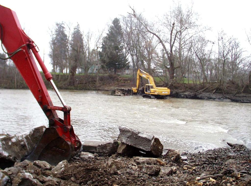
10 Ohio s Scenic Rivers DESIGNATIONS Wild Scenic Recreational RIVERS Ashtabula River Big & Little Darby Creeks Chagrin River Conneaut Creek Grand River Kokosing River Little Beaver Creek Little Miami River Maumee River Mohican River Olentangy River Sandusky River Stillwater River Upper Cuyahoga
11 Program Priorities Protect riparian buffer and stream habitat Technical assistance on development issues Stream Quality Monitoring Project Land acquisition - ORC Dam Removal Implement Scenic River Law ORC Watershed Planning

12 Ohio Scenic River Law Approval of publicly funded projects within 1,000 foot corridor such as: Bridge projects Roads paralleling rivers Culvert replacements Waterlines/Sewerlines Park development - trails Bank stabilization

13 Benefits of Dam Removal Safety Hazard drowning hydraulics
14 Benefits of Dam Removal Ecological Negatively impact biological community Riverine to lacustrine loss of riffle, pool run complex Lower species diversity, tolerant spp. predominant Lower water quality, D.O. Impede natural movement of bed load

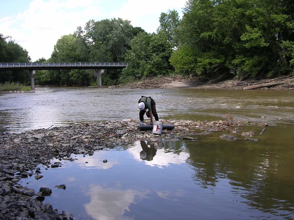
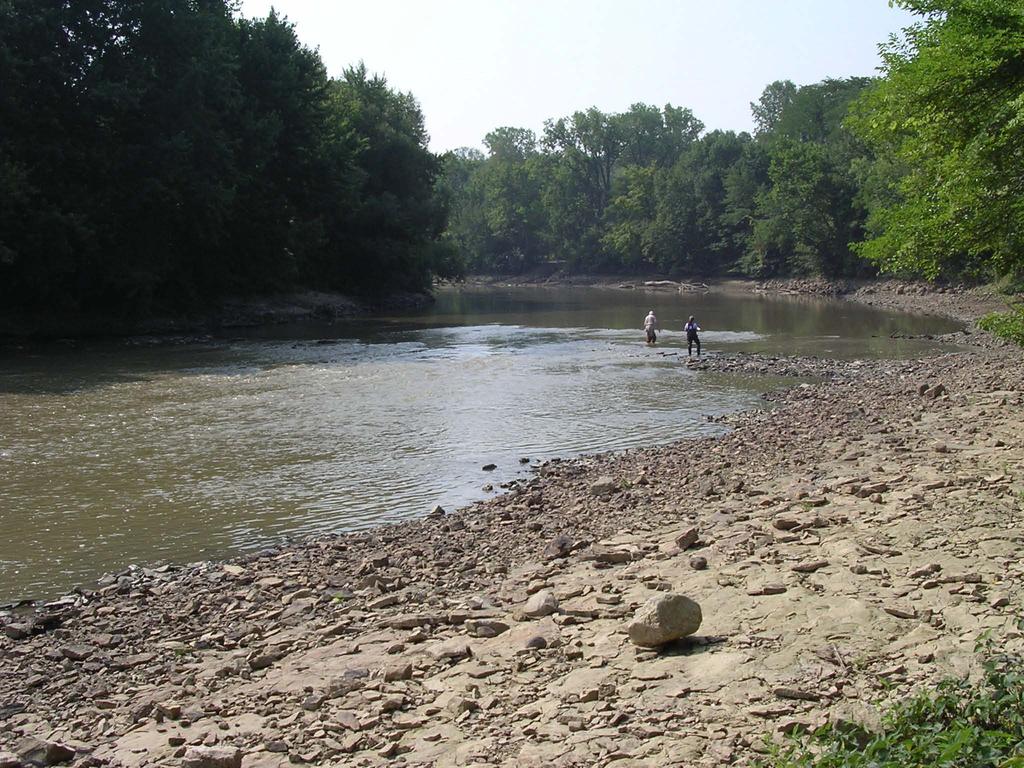
15 Benefits of Dam Removal Ecological Excessive sedimentation - substrate embeddedness


16 Macroinvertebrates Live in interstitial spaces critical level in food chain Unionid Mollusks Sediment on gill surface causes decreased food filtering efficiency and asphyxiation


17 Simple Lithophils - need a hard, clean, rocky substrate to lay eggs on - provide no parental care Shorthead Redhorse Moxostoma macrolepidotum Benthic Insectivores - need a hard, clean, rocky substrate feed on macroinvertebrates Hog Sucker Hypentelium nigricans
18 Dam Removal Sandusky State Scenic River St. Johns Dam Constructed 1935 by Ohio-American Water Company Backup water supply for the city of Tiffin Inspection in 1999 by ONDR, Division of Water determined the dam was unsafe 150 feet long, 7 feet high Impounded 8.5 miles of Sandusky River

19
20
21 St. Johns Dam Research Project Partners Macroinvertebrates Heidelberg, Dr. Ken Krieger ODNR, Division of Natural Areas and Preserves Bivalve Unionids OSU, Dr. Tom Watters Fish ODNR, Division of Wildlife, Natural Areas and Preserves Geologic mapping of stream ODNR, Division of Geological Survey, Lake Erie Group Qualitative Habitat Evaluation Index (QHEI) - Ohio Department of Transportation Additional independent research OSU, Dr. Tim Granata Sites monitored before after removal 5 yr. study
22 Dam Removal St. Johns Dam Research Monitoring sites above and below dam Monitoring at Ohio Environmental Protection Agency reference sites Detailed mapping was completed by the ODNR Division of Geological Survey 9/22/03 to 11/4/03 Post dam removal mapping was performed in 7/26-27/04, 10/25/04, and 10/27-28/04


23 Macroinvertebrates Utilized Hester-Dendy samplers per OEPA protocol Monitoring 7 sites, some samplers lost in high water first year
24 St. Johns Research Results Macroinvertebrates Species Dam East 2003 Dam West 2003 Walnut Grove 2003 Dam East 2004 Dam West 2004 Walnut Grove 2004 Total # Taxa Total # Individuals ,800+ 1,
25 St. Johns Research Results Captured Fish Species Species Above Dam 2003 Walnut Grove 2003 Above Dam 2004 Walnut Grove 2004 Above Dam 2005 Walnut Grove 2005 Black Redhorse Golden Redhorse Greater Redhorse (T) River Redhorse (I) Common Carp Smallmouth Bass Green Sunfish
26 St. Johns Research Results Unionid Bi-valves Species Richness vs. River Mile Species Richness River Mile
27


28 Mexico Bridge Reach: St. John s Dam Substrate, morphology, and river s edge was mapped in the Summer and Fall of 2004 for comparison to mapping before the St. John s Dam removal in 2003 Mexico Bridge

29 Substrate Before Dam Removal (2003) Mexico Bridge Sandusky River Carbonate Bedrock Boulder and Slabs Cobble and Boulder Gravel and Cobble 1, ,000Feet Sand and Mud

30 Substrate After Dam Removal (2004) Mexico Bridge Sandusky River Carbonate Bedrock Boulder and Slabs Cobble and Boulder Gravel and Cobble 1, ,000Feet Sand and Mud

31 Morphology Before Dam Removal (2003) Sandusky River Riffle Run Glide 1, ,000Feet Pool Bar
32 Morphology After Dam Removal (2004) Sandusky River Riffle Run Glide 1, ,000Feet Pool Bar
33 Mexico Bridge Region Substrate Type And Acreage Before Dam Removal (2003) 2003 Substrate Acreage Series Any Boulder/Cobble/Gravel Mix Any Gravel/Cobble w/ some Sand Mix Substrate Type Any Mud/Sand Mix
34 Mexico Bridge Region Substrate Type And Acreage After Dam Removal (2004) 2004 Substrate Acreage Series Any Boulder/Cobble/Gravel Mix Any Gravel/Cobble w/ some Sand Mix Substrate Type Any Mud/Sand Mix
35
Dam Removal and River Restoration in Watershed Planning
 LOCAL WATER, GLOBAL WATER. ESP, DENISON UNIV. 2003 Dam Removal and River Restoration in Watershed Planning Tim Granata Ecological Engineer Department of Civil & Environmental Engineering & Geodetic Science
WATER QUALITY STANDARDS. Chapter of the ADMINISTRATIVE CODE. December 15, 2009 Effective March 15, 2010
 STATE OF OHIO WATER QUALITY STANDARDS Chapter 3745-1 of the ADMINISTRATIVE CODE Most Recent Revision: December 15, 2009 Effective March 15, 2010 Ohio Environmental Protection Agency Division of Surface
4. What is Item A called? a. Eckman dredge b. Secchi disk c. Van Dorn sampler d. Ponar sampler
 Envirothon Questions for AQUATICS station April 24, 2013 1. Eutrophication often results in large fish kills. What is the major cause of these fish kills? a. Oxygen has been depleted due to the decay of
Ohio s Water Resources
 Ohio 2010 Integrated Report Section B Ohio s Water Resources B1. Facts and Figures Ohio is a water-rich state bounded on the south by the Ohio and the north by Lake Erie. These water bodies, as well as
2012 Mill Creek Watershed Habitat Assessment Level 3 Project Study Plan Results
 2012 Mill Creek Watershed Habitat Assessment Level 3 Project Study Plan Results Cranberry Run This project study plan was financed through a Sub-grant from the Ohio EPA with funds from the State of Ohio.
S.R. 4007, Section 14B PADEP Environmental Assessment Form. Enclosure C Description of Aquatic Habitat
 S.R. 4007, Section 14B PADEP Environmental Assessment Form Description of Aquatic Habitat Cresheim Creek is the only water resource that exists within the project area. No jurisdictional wetlands were
2007 Cuyahoga River Biological, Water Quality and Habitat Survey Results
 2007 Cuyahoga River Biological, Water Quality and Habitat Survey Results Introduction During 2007, the Northeast Ohio Regional Sewer District 1 (NEORSD) conducted electrofishing, benthic macroinvertebrate
2015 State Envirothon
 *Disclaimer: These tests do not reflect the information that will be on tests at the upcoming competitions.* 2015 State Envirothon Aquatics Test (75 Points Total) MULTIPLE CHOICE: Select the best possible
Riparian Setback- What is that and what should I be doing? October 25th, 2016 Presented by: Anil Tangirala, PE, CFM, ENV SP
 Riparian Setback- What is that and what should I be doing? October 25th, 2016 Presented by: Anil Tangirala, PE, CFM, ENV SP Agenda Introduction Stream and Riparian Impacts Ohio EPA Stormwater General Permit
A Claytor Nature Center Stream Monitoring Experience
 A Claytor Nature Center Stream Monitoring Experience Conduct field investigations in which distinctions are made among observations, hypotheses, results and conclusions Perform a visual habitat assessment
Waters of the U.S. and State And Aquatic Life
 Waters of the U.S. and State And Aquatic Life Waters Streams Wetlands Ditches Ponds, Lakes, and Reservoirs Aquatic Life Fish Macrobenthos Unionid Mussels Aquatic Ecology: Streams Goals of stream sampling
5 th Avenue Dam Removal & Lower Olentangy River Ecosystem Restoration Project
 5 th Avenue Dam Removal & Lower Olentangy River Ecosystem Restoration Project October 2013 Agenda 1 Project Background 2 Design Report 3 Design Process 4 Permitting 5 Construction 1 Project Background
Environmental Assessment Form Part 1 Resource Identification Enclosure C Description of Aquatic Habitat
 Environmental Assessment Form Part 1 Resource Identification Enclosure C Description of Aquatic Habitat 8. Provide a written narrative, identified and labeled as Enclosure C Description of Aquatic Habitat,
Maumee Area of Concern Water Quality Database Development
 Maumee Area of Concern Water Quality Database Development Project Overview Background In 1987 the Maumee Area of Concern (AOC) in northwest Ohio was designated as an Area of Concern based on the identification
Upper Des Plaines River Feasibility Study
 Upper Des Plaines River Feasibility Study Appendix M Monitoring & Adaptive Management Plan August 2013 Study Partnership Illinois Department of Natural Resources (IDNR) Southeastern Wisconsin Regional
Aquatic Mitigation Riverside Oxbow and Sycamore Creek Restoration
 Aquatic Mitigation Riverside Oxbow and Sycamore Creek Restoration Brian Murphy, P.E., D.WRE July 30, 2014 Overview Central City Project Marine Creek Sycamore Creek Design (Criteria & Approach) Summary
Carp Creek 2013 Summary Report
 Monitoring Activity in the Carp River Watershed In 2012, Mississippi Valley Conservation Authority (MVCA) worked with Friends of the Carp River (FCR) on a preliminary assessment of the Carp River. This
CLEARWATER TOWNSHIP WATER QUALITY ACTION PLAN
 CLEARWATER TOWNSHIP WATER QUALITY ACTION PLAN Elk-River-Chain-of-Lakes Gaps Analysis Project The Watershed Center Grand Traverse Bay Michigan Department of Environmental Quality July 2011 Purpose The Grand
Beaver Creek Hydrology, LLC. Franklin, Tennessee
 Beaver Creek Hydrology, LLC. Franklin, Tennessee The Harpeth River Blueway Problems with Harpeth River EPA s 303(d) Listed for siltation, habitat alteration, nutrient enrichment and low dissolved oxygen
Watershed Investigations: How to Assess the Health of a Stream
 Watershed Investigations: How to Assess the Health of a Stream By Joan Chadde, Western UP Center for Science, Mathematics & Environmental Education. All photos by author, unless otherwise noted. Why Monitor
Watts Creek 2014 Summary Report
 Monitoring Activity in the City of Ottawa In 2012, Mississippi Valley Conservation Authority (MVCA) and the Friends of the Carp River (FCR) collaborated to undertake a broad scale assessment of potential
Boardman River Townships Project EAST BAY TOWNSHIP. WATER QUALITY ACTION PLAN Fall 2009
 Boardman River Townships Project EAST BAY TOWNSHIP WATER QUALITY ACTION PLAN Fall 2009 Partners: The Watershed Center Grand Traverse Bay Northwestern Michigan College - Great Lakes Water Studies Institute
Fish Passage and Abundance around Grade Control Structures on Incised Streams in Western Iowa
 Fish Passage and Abundance around Grade Control Structures on Incised Streams in Western Iowa John Thomas Hungry Canyons Alliance Mary Culler Iowa State University / Missouri DNR Dimitri Dermisis IIHR
Stream Health. Stream Bugs Our Stream Health Communicators. Upper Nottawasaga River Stream Health. NVCA Science & Stewardship
 NVCA Science & Stewardship Stream Health Upper Nottawasaga River, 2015 Stream Bugs Our Stream Health Communicators Stream bugs (benthic macroinvertebrates) are organisms that spend much or all of their
ENVIROTHON AQUATICS SAMPLE TEST
 ENVIROTHON AQUATICS SAMPLE TEST Habitat Assessment Perform a visual assessment (habitat assessment) of Coalburn Creek within the designated area (100 meter reach). You will be provided with the habitat
LIMITED ENVIRONMENTAL REVIEW
 Division of Environmental and Financial Assistance Office of Financial Assistance Water Resource Restoration Sponsor Program LIMITED ENVIRONMENTAL REVIEW A. Project Identification Project Name: Project
Developing a multi-metric habitat index for wadeable streams in Illinois (T-25-P-001).
.") T E C H N I C A L R E P O R T Developing a multi-metric habitat index for wadeable streams in Illinois (T-25-P-001). Annual Segment Report to the Illinois Department of Natural Resources. Laura L. Sass,
T E C H N I C A L R E P O R T Developing a multi-metric habitat index for wadeable streams in Illinois (T-25-P-001). Annual Segment Report to the Illinois Department of Natural Resources. Laura L. Sass,
Trends in water quality across Ohio watersheds
 Trends in water quality across Ohio watersheds Laura Johnson and Ken Krieger Ohio Water Resources Council Workgroup for Water Resources Monitoring 1 March 1 Heidelberg Tributary Loading Program 1 stations
Brian A. Metzke. Illinois Natural History Survey Prairie Research Institute University of Illinois. 18 December INHS Technical Report 2015 (41)
") Monitoring and Evaluation of United States Fish and Wildlife Service Partners for Fish and Wildlife Program Stream Restorations in Illinois (Progress Report for 7/1/2015 12/31/2015) Brian A. Metzke Illinois
Monitoring and Evaluation of United States Fish and Wildlife Service Partners for Fish and Wildlife Program Stream Restorations in Illinois (Progress Report for 7/1/2015 12/31/2015) Brian A. Metzke Illinois
Jan Moryk, Project Manager, Environmental Monitoring and Data Management Section, TRCA
 Distribution of Brook Trout in the TRCA Jurisdiction and what Legislation, Policies, and Guidelines do Conservation Authorities have at their disposal to Protect Brook Trout Habitat Jan Moryk, Project
WATERSHED. Maitland Valley. Report Card 201
 Maitland Valley WATERSHED Report Card 201 The Maitland Valley Conservation Authority has prepared this report card as a summary on the state of our forests, wetlands, surface water, and ground water resources.
Ohio Bioassessments - Applicatio
 Must be conducted if important aquatic ecological resources or sediments are impacted (or chemical of concern has no sediment benchmark value in the benchmark hierarchy) Must demonstrate compliance with
SUMMARY OF INDIAN MILL CREEK WATERSHED ASSESSMENT KENT, MICHIGAN
 SUMMARY OF INDIAN MILL CREEK WATERSHED ASSESSMENT KENT, MICHIGAN INTRODUCTION BY: MARY SIEVERT, STUDENT ASSISTANT AND JANICE TOMPKINS, SENIOR WATER QUALITY ANALYST FIELD OPERATION SECTION WATER DIVISION
Division of Surface Water Response to Comments
 Division of Surface Water Rule: Water Quality Standards Beneficial Use Designation Rules OAC Chapter 3745-1 Agency Contact for this Package Division Contact: Dan Dudley Division of Surface Water 614-644-2876
Appendix H: Stream Habitat Assessment
 Appendix H: Stream Habitat Assessment H CH2MHill and Greenways Incorporated conducted Stream Habitat Assessments on several streams throughout Wake County to determine the affect of development density
ACTIVITIES AUTHORIZED BY 2012 NATIONWIDE PERMIT
 ACTIVITIES AUTHORIZED BY 2012 NATIONWIDE PERMIT 33. Temporary Construction, Access, and Dewatering. Temporary structures, work, and discharges, including cofferdams, necessary for construction activities
Dolores River Management Plan. (Update of the 1990 Dolores River Corridor Management Plan)
") Dolores River Management Plan (Update of the 1990 Dolores River Corridor Management Plan) Topics of Discussion 1968 Wild and Scenic Rivers Act, Public Law 90-542 1976 Dolores River Wild and Scenic River
Dolores River Management Plan (Update of the 1990 Dolores River Corridor Management Plan) Topics of Discussion 1968 Wild and Scenic Rivers Act, Public Law 90-542 1976 Dolores River Wild and Scenic River
APPENDIX C REPRESENTATIVE HABITAT PHOTOGRAPHS
 APPENDIX C REPRESENTATIVE HABITAT PHOTOGRAPHS 1304 119 Combined Vegetation and TES assesment 9a 10 8b 1,2 3a 6a 6b 11 9b 3b 4b 5c, 5d 4a 5b 8a 7b 5a Appendix C. Approximate Location of Representative Habitat
Jan Moryk, Project Manager, Environmental Monitoring and Data Management Section, TRCA
 Distribution of Brook Trout in the TRCA Jurisdiction and what Legislation, Policies, and Guidelines do Conservation Authorities have at their disposal to Protect Brook Trout Habitat Jan Moryk, Project
Urban Riparian & Stream Restoration Program: Management & Photo Monitoring. Texas Water Resource Institute
 Urban Riparian & Stream Restoration Program: Management & Photo Monitoring Texas Water Resource Institute Hindrances to Healthy / Functional Riparian Areas: Farming too close to the bank Mowing, spraying
IMPROVING OUTCOMES FOR STREAM ALTERATION PROJECTS
 IMPROVING OUTCOMES FOR STREAM ALTERATION PROJECTS Bethany Matousek Inland Lakes and Streams Program Coordinator Wetlands, Lakes and Streams Unit DEQ Water Resources Division MatousekB@Michigan.gov 517-243-6421
ENVIRONMENTAL ASSESSMENT For Village of Williamsburg Williamsburg Low-Head Dam Removal WR
 ENVIRONMENTAL ASSESSMENT For Village of Williamsburg Williamsburg Low-Head Dam Removal WR390997-0006 Applicant: Honorable Mary Anne Lefker, Mayor Village of Williamsburg 107 West Main Street Williamsburg,
John Vile, MS Water Monitoring & Standards Bureau of Freshwater and Biological Monitoring
 NJ Fish Index of Biotic Integrity John Vile, MS Water Monitoring & Standards Bureau of Freshwater and Biological Monitoring Program Objectives Determine the current Status of fish communities, which reflect
In re: Town of Norwich Pool Dam Reconstruction, Stream Alteration Permit Application
 Agency of Natural Resources October 20, 2015 Neil R. Fulton Town Manager Town of Norwich P.O. Box 376 Norwich, VT 05055 In re: Town of Norwich Pool Dam Reconstruction, Stream Alteration Permit Application
Stream Restoration Raccoon Creek A Case Study
 Stream Restoration Raccoon Creek A Case Study Restoration of a Degraded Stream System Steven Glickauf Presentation Overview Stream Restoration Raccoon Creek Restoration Site Case Study Existing Conditions
Pymatuning Creek State Wild and Scenic River Designation Study September 2018
 Pymatuning Creek State Wild and Scenic River Designation Study September 2018 Pymatuning Creek State Wild and Scenic River Designation Study A Study of the Pymatuning Creek for Inclusion into Ohio s Scenic
Report on Biological & Water Quality Monitoring in the East Branch DuPage Watershed: 2014
 Report on Biological & Water Quality Monitoring in the East Branch DuPage Watershed: 2014 DuPage River-Salt Creek Work Group April 26, 2017 Chris O. Yoder Midwest Biodiversity Institute Columbus, OH 2014
Missouri Streams. Fact Sheet. What factors affect stream habitat? Stream Habitat Affects Aquatic Communities
 Missouri Streams Fact Sheet Written by Del Lobb & Suzanne Femmer Edited by Sarah Wolken When most people think of habitat, they usually picture places where fish or wildlife live, like a hollow log or
Developing a multi-metric habitat index for wadeable streams in Illinois (T-25-P-001).
.") T E C H N I C A L R E P O R T Developing a multi-metric habitat index for wadeable streams in Illinois (T-25-P-001). Annual Segment Report to the Illinois Department of Natural Resources. Leon C. Hinz
T E C H N I C A L R E P O R T Developing a multi-metric habitat index for wadeable streams in Illinois (T-25-P-001). Annual Segment Report to the Illinois Department of Natural Resources. Leon C. Hinz
Ecology and River Restoration
 Ecology and River Restoration Ecology is the study of the relationships between plants and animals and the environment in which they live. Owen, 1980 Martin Janes Managing Director The River Restoration
Mill Creek Restoration in Lower Merion Township. PH (610) ; FAX (610) ;
 ; FAX (610) ;") Mill Creek Restoration in Lower Merion Township Vincent L. Sortman 1 and Robert M. Lambert 2 1 Biohabitats, Inc., 15 W. Aylesbury Road, Timonium, MD 21093; PH (410) 337-3659; FAX (410) 583-5678; email:
Mill Creek Restoration in Lower Merion Township Vincent L. Sortman 1 and Robert M. Lambert 2 1 Biohabitats, Inc., 15 W. Aylesbury Road, Timonium, MD 21093; PH (410) 337-3659; FAX (410) 583-5678; email:
Riparian Ecology Station OBJECTIVES
 Riparian Ecology Station OBJECTIVES Students learn The basic definition of a riparian area. The condition of any riparian area greatly affects the water quality and aquatic habitat of the water body it
Survey of Bottom Substrate Composition and Fish Habitat Value at Nett Lake
 Survey of Bottom Substrate Composition and Fish Habitat Value at Nett Lake Prepared by: Frank G. Stone, U.S. Fish & Wildlife Service Ashland FRO May 2006 The objective of this project was to characterize
MANZANITA LAKE PLANNING UNIT Willow Creek Watershed
 Existing Conditions & Uses Overview Area surrounding a small afterbay and creeks with ethnobotanical resources and valuable habitat 472 acres in Madera County; 337 acres outside the FERC boundary and 135
S.R. 2027, Section 02B PADEP Environmental Assessment Form. Enclosure C Description of Aquatic Habitat
 S.R. 2027, Section 02B PADEP Environmental Assessment Form Description of Aquatic Habitat Water resources that exist within the project area include Hosensack Creek and two palustrine emergent (PEM) wetlands.
Exploring Our Heritage
 Teacher Overview Ohio s natural water resources have played very important roles in the development of the state and nation. The Ohio River for example, has important significance to the development of
Ohio Environmental Protection Agency WATER QUALITY IMPROVEMENT GRANTS LAKE ERIE WATERSHED
 Ohio Environmental Protection Agency WATER QUALITY IMPROVEMENT GRANTS LAKE ERIE WATERSHED The following summaries describe projects that are recommended funding in the Lake Erie These projects have been
COTTON CREEK CULVERT REPLACMENT
 COTTON CREEK CULVERT REPLACMENT Integrating Mobility with Environmental Innovation Located along a scenic section of Highway 3/95 in British Columbia, Moyie Bluffs, a 6.5 km stretch of inland highway had
Issuing Office: CELRB-PM-EA Published: 22 FEB 2019 Notice No: SANDUSKY-19 Expires: 25 MAR 2019
 Public Notice Issuing Office: CELRB-PM-EA Published: 22 FEB 2019 Notice No: SANDUSKY-19 Expires: 25 MAR 2019 OPERATION AND MAINTENANCE DREDGING AND DREDGED SEDIMENT PLACEMENT SANDUSKY HARBOR ERIE COUNTY,
Jennifer S. Simmons, National Mine Land Reclamation Center, West Virginia University, Morgantown, WV.
 Acid Mine Drainage Neutralization at Augusta Lake, Indiana Mike Kalagian, Office of Surface Mining, Indianapolis, IN Jennifer S. Simmons, National Mine Land Reclamation Center, West Virginia University,
Stream Buffers Sharpest Tool in the SWM Toolbox Tom Hegemier, PE, D.WRE, CFM
 Stream Buffers Sharpest Tool in the SWM Toolbox 1 Tom Hegemier, PE, D.WRE, CFM www.apaienv.com Stream Buffers - Overview 2 Why stream buffers? Floodplain management and other benefits Existing regulatory
Maine s Land Use Regulations and Erosion Control Techniques
 Maine s Land Use Regulations and Erosion Control Techniques Protecting Maine s Air, Land and Water Colin Clark 441-7419 colin.a.clark@maine.gov Tom Gilbert 441-8031 thomas.gilbert@maine.gov Jim Rodrigue
8. A. AQUATIC HABITATS
 ENCLOSURE C S.R. 1006 SECTION 80S DELAWARE CANAL BRIDGE REHABILITATION PROJECT, TINICUM TOWNSHIP, BUCKS COUNTY, PENNSYLVANIA DESCRIPTION OF AQUATIC HABITAT 8. A. AQUATIC HABITATS (1) Food Chain Production-
Environmental Flow Regimes. Joe Trungale s presentation to the Science Advisory Committee March 4, 2009
 Overlays to Hydrology-Based Environmental Flow Regimes Joe Trungale s presentation to the Science Advisory Committee March 4, 2009 Overlays - Definition Application of analysis to validate or refine flow
THE WATERSHED The watershed is an area of land that drains into a stream. This includes both the surface runoff and groundwater. Because a stream is m
 Understanding Streams A stream is the product of its watershed. Good land use in the watershed will be reflected in the stream. MOST PEOPLE enjoy the captivating qualities of flowing water. But streams
LEGAL AUTHORITY AND JURISDICTIONS
 CALIFORNIA DEPARTMENT OF FISH AND GAME RIPARIAN RESOURCES AND REGULATORS: The DFG Lake and Streambed Alteration 1600 Process LEGAL AUTHORITY AND JURISDICTIONS Serge Glushkoff CENTRAL COAST REGION YOUNTVILLE
Stormwater Management Training for MS4 Municipal Employees
 Stormwater Management Training for MS4 Municipal Employees Grant Supported Through: Ohio Environmental Education Fund In Partnership: City of Cleveland Mayor s Office of Sustainability Chagrin River Watershed
ANCR INDIVIDUAL RESPONSES SUMMARY: 2/11/04 WATER RESOURCES GOALS AND OBJECTIVES
 ANCR INDIVIDUAL RESPONSES SUMMARY: 2/11/04 WATER RESOURCES GOALS AND OBJECTIVES Goal 1: Protect the health and safety of the Dane County population. a. Prevent development that may have an adverse effect
Stevens Creek Steelhead Limiting Factors Analysis. Stillwater Sciences
 Stevens Creek Steelhead Limiting Factors Analysis Stillwater Sciences May 18, 2004 Project Goals! Identify and fill information gaps related to physical and biological factors controlling population dynamics
A GUIDE TO THE WETLAND, DEEPWATER HABITATS, AND RIPARIAN CLASSIFICATIONS USED IN WETLAND AND RIPARIAN MAPPING IN MONTANA
 A GUIDE TO THE WETLAND, DEEPWATER HABITATS, AND RIPARIAN CLASSIFICATIONS USED IN WETLAND AND RIPARIAN MAPPING IN MONTANA Purpose: The Montana Natural Heritage Program s Wetland and Riparian Mapping Center
VEGETATIVE, WATER, FISH AND WILDLIFE RESOURCES POLICIES
 VEGETATIVE, WATER, FISH AND WILDLIFE RESOURCES POLICIES The County will: GOALS AND OBJECTIVES 1.1 Conserve, Enhance, Protect, Maintain and Manage Vegetative, Water, Fish and Wildlife Resources Promote
November 15 th, 2012 WMAO 2012 Fall Conference 100 Years of Watershed Events. Amy Mackey Raccoon Creek Watershed Coordinator
 November 15 th, 2012 WMAO 2012 Fall Conference 100 Years of Watershed Events Amy Mackey Raccoon Creek Watershed Coordinator Surface Mining Control & Reclamation Act of 1977 (SMCRA) watershed event most
ELK RAPIDS TOWNSHIP WATER QUALITY ACTION PLAN
 ELK RAPIDS TOWNSHIP WATER QUALITY ACTION PLAN Elk-River-Chain-of-Lakes Gaps Analysis Project The Watershed Center Grand Traverse Bay Tip of the Mitt Watershed Council Michigan Department of Natural Resources
Construction of Artificial Riffles and Pools For Freshwater Habitat Restoration
 Construction of Artificial Riffles and Pools For Freshwater Habitat Restoration Kate Howe Preserving biodiversity is one of the central goals of ecologists and conservation biologists today. As human population
Rascal Goose. Reach 1. Rascal Goose. Reach 2. å å å. Main Goose Pit. Stream Reach 3. Main Goose Pit. Stream Reach 7
 434000 March 16 2014 434200 434400 ± 434600 434800 435000 Goose Lake 7269800 WRSA B 7269800 7270000 433800 GIS # BAC-06-180a 7270000 PROJECT # 0234411-0005 Rascal Goose Reach 1 Main Goose Pit Stream Reach
California Rapid Assessment Method for Wetlands (CRAM) Buffer and Landscape Context Attribute
 Buffer and Landscape Context Attribute") California Rapid Assessment Method for Wetlands (CRAM) Buffer and Landscape Context Attribute Buffer and Landscape Context Attribute Presence and/or continuity of wetlands and riparian areas adjacent to
California Rapid Assessment Method for Wetlands (CRAM) Buffer and Landscape Context Attribute Buffer and Landscape Context Attribute Presence and/or continuity of wetlands and riparian areas adjacent to
1/16/2016. California Rapid Assessment Method for Wetlands (CRAM) Buffer and Landscape Context Attribute. Buffer and Landscape Context Attribute
 Buffer and Landscape Context Attribute. Buffer and Landscape Context Attribute") California Rapid Assessment Method for Wetlands (CRAM) Buffer and Landscape Context Attribute Buffer and Landscape Context Attribute Presence and/or continuity of wetlands and riparian areas adjacent to
California Rapid Assessment Method for Wetlands (CRAM) Buffer and Landscape Context Attribute Buffer and Landscape Context Attribute Presence and/or continuity of wetlands and riparian areas adjacent to
Chapter 3: Methods for the Assessment of Habitat using the Qualitative Habitat Evaluation Index (QHEI)
") Chapter 3: Methods for the Assessment of Habitat using the Qualitative Habitat Evaluation Index (QHEI) TABLE OF CONTENTS 3.0 INTRODUCTION... 66 3.0.1 Background...66 3.0.2 Scope... 66 3.1 METHODS...66
Chapter 3: Methods for the Assessment of Habitat using the Qualitative Habitat Evaluation Index (QHEI) TABLE OF CONTENTS 3.0 INTRODUCTION... 66 3.0.1 Background...66 3.0.2 Scope... 66 3.1 METHODS...66
PROPOSED. Notification: The ODOT must submit a Pre-Construction Notification (PCN) to the District Engineer prior to commencing the activity:
 to the District Engineer prior to commencing the activity:") PROPOSED Categories of Activities Covered by the Regional General Permit (RGP): This RGP authorizes activities in waters of the United States (U.S.) including work, structures, and the discharge of fill
PROPOSED Categories of Activities Covered by the Regional General Permit (RGP): This RGP authorizes activities in waters of the United States (U.S.) including work, structures, and the discharge of fill
14(h)EPA-06 City of Springfield 76 East High Street Springfield, Ohio Clark County Greening City Plaza
EPA-06 City of Springfield 76 East High Street Springfield, Ohio Clark County Greening City Plaza") 14(h)EPA-06 City of Springfield 76 East High Street Springfield, Ohio 45502 Clark County Greening City Plaza $100,000 in FY 2014 Section 319(h) Nonpoint Source grant funding is requested to install three
14(h)EPA-06 City of Springfield 76 East High Street Springfield, Ohio 45502 Clark County Greening City Plaza $100,000 in FY 2014 Section 319(h) Nonpoint Source grant funding is requested to install three
Chapter Four: Overview. Introduction to Environmental Geology, 5e. Case History: Endangered Trout. Ecology and Geology Linkage
 Chapter Four: Overview Introduction to Environmental Geology, 5e Chapter 4 Ecology and Geology Jennifer Barson Spokane Falls Community College Linkages between geology with ecology and relationships with
Ecological Flow Assessments in Eastern U.S. Basins Tara Moberg. December 10, 2014 NAS Roundtable on Science and Technology for Sustainability
 Ecological Flow Assessments in Eastern U.S. Basins Tara Moberg December 10, 2014 NAS Roundtable on Science and Technology for Sustainability What are Ecological Flows? The flow of water in a natural river
Habitat Assessment Report for Candidate Phase 1 Areas Hudson River PCBs Superfund Site
 Habitat Assessment Report for Candidate Phase 1 Areas PCBs Superfund Site Community Advisory Group (CAG) Meeting December 8, 2005 Habitat Related Documents Habitat Delineation and Assessment Work Plan
Truckee River Aquatic Invasive Plant Survey Results
 Truckee River Aquatic Invasive Plant Survey Results Submitted by U.C. Davis, Tahoe Environmental Research Center Prepared by Katie Senft and Brant Allen Submitted August 1, 2016 Contact for questions and
Final Report. Survey for Freshwater Mussels in the South Fork Rivanna River at the Proposed Route 29 Bypass Crossing
 Final Report Survey for Freshwater Mussels in the South Fork Rivanna River at the Proposed Route 29 Bypass Crossing Project Number# 6029-002-F22; UPC 16160 Prepared by Brett J. K. Ostby, Tim Lane, Matthew
Appendix A. Location of Transects, Study Sections, Instream Structures and U.S. Geological Survey Gage Stations -Russian River and Lower Dry Creek
 scanned for KRIS Appendix A Location of Transects, Study Sections, Instream Structures and U.S. Geological Survey Gage Stations -Russian River and Lower Dry Creek Symbols used are defined in the following
Habitat Grant Projects Clinton River Watershed
 Habitat Grant Projects Clinton River Watershed L Y N N E S E Y M O U R E N V I R O N M E N T A L E N G I N E E R O F F I C E O F T H E M A C O M B C O U N T Y P U B L I C W O R K S C O M M I S S I O N
Ceresco Dam Removal Project. Michigan Watershed Summit March 25, 2015 Luke Trumble, P.E., MDEQ-WRD Jay Wesley, MDNR-Fisheries
 Ceresco Dam Removal Project Michigan Watershed Summit March 25, 2015 Luke Trumble, P.E., MDEQ-WRD Jay Wesley, MDNR-Fisheries Outline Overview of Ceresco Dam History Public Process Funding Dam Removal Ecosystem
Determining Appropriate Compensatory Mitigation Credit for Dam Removal Projects in North Carolina
 Determining Appropriate Compensatory Mitigation Credit for Dam Removal Projects in North Carolina Developed cooperatively by: US Army Corps of Engineers, Wilmington District US Environmental Protection
1 ECOLOGICAL INTEGRITY
 NH METHOD FOR THE EVALUATION OF FRESHWATER WETLANDS (revised December, 2) ECOLOGICAL INTEGRITY. Are there land uses in the wetland s watershed that could degrade water quality in the wetland? a. Less than
Port Authority of Eastlake Park Planning Project Steering Committee Meeting
 Port Authority of Eastlake Park Steering Committee Meeting January 23. 2013 MKSK is a landscape architecture, urban design, and planning firm with offices in Columbus, Covington and Indianapolis. MKSK
Michigan Technological University GK12 Global Watershed Program
 All About Rivers Target Grade Level Biology (7 th -8 th Grade) Unit Summary: This unit is designed to introduce students to the physical structure of rivers, the organisms that are found or associated
STREAM INVENTORY REPORT PUDDING CREEK
 STREAM INVENTORY REPORT PUDDING CREEK WATERSHED OVERVIEW Pudding Creek is a tributary to the Pacific Ocean (Figure 1). Elevations range from sea level at the mouth of the creek to 1,600 feet in the headwater
Chapter 105 Dam Safety and Waterway Management
 Chapter 105 Dam Safety and Waterway Management An overview PA Department of Environmental Protection Bureau of Watershed Management Division of Waterways, Wetlands, & Stormwater Management Purpose The
CNL(10)51. NASCO Guidelines for the Protection, Restoration and Enhancement of Atlantic salmon Habitat
51. NASCO Guidelines for the Protection, Restoration and Enhancement of Atlantic salmon Habitat") CNL(10)51 NASCO Guidelines for the Protection, Restoration and Enhancement of Atlantic salmon Habitat 1. Introduction Salmon habitat in freshwater has been greatly affected by various activities, both
CNL(10)51 NASCO Guidelines for the Protection, Restoration and Enhancement of Atlantic salmon Habitat 1. Introduction Salmon habitat in freshwater has been greatly affected by various activities, both
ROLE OF THE FIRM IN THE PROJECT
 PROJECT DESCRIPTION Lake Loramie Dam is a Class I dam located in Lake Loramie State Park in Minster, Ohio. Lake Loramie originally served as the high feeder water supply for the Miami-Erie Canal that began
APPENDIX A-3 SALUDA HYDROELECTRIC PROJECT LOWER SALUDA RIVER BENTHIC MACROINVERTEBRATE MONITORING AND ENHANCEMENT PROGRAM
 APPENDIX A-3 SALUDA HYDROELECTRIC PROJECT LOWER SALUDA RIVER BENTHIC MACROINVERTEBRATE MONITORING AND ENHANCEMENT PROGRAM SOUTH CAROLINA ELECTRIC & GAS COMPANY COLUMBIA, SOUTH CAROLINA SALUDA HYDROELECTRIC
Public Notice. N/A March 18, 2017 NATIONWIDE PERMITS FOR THE STATE OF OHIO CORPS OF ENGINEERS REGULATORY PROGRAM ISSUANCE OF NATIONWIDE PERMITS
 Public Notice U S Army Corps of Engineers Pittsburgh District In reply refer to Public Notice No. Stream: Issuance Date: March 19, 2012 Closing Date: N/A March 18, 2017 Please address all comments and
Information for EFSAB:
 Information for EFSAB: Stream-ecology and flow relationships based on our ACF research Transferability of species preferences Defensibility of ACF work in context of controversy Mary Freeman USGS Patuxent
Ongoing and Completed Studies
 Attachment 2 Ongoing and Completed Studies 2014 Monitoring and Analysis Plan November 2013 Attachment 2 Ongoing and Completed Studies 1 Introduction In 2013, the small interdisciplinary study groups for