Appendix A. Location of Transects, Study Sections, Instream Structures and U.S. Geological Survey Gage Stations -Russian River and Lower Dry Creek
|
|
|
- April Gray
- 6 years ago
- Views:
Transcription
1 scanned for KRIS Appendix A Location of Transects, Study Sections, Instream Structures and U.S. Geological Survey Gage Stations -Russian River and Lower Dry Creek Symbols used are defined in the following example
2 MAINSTEM RUSSIAN RIVER
3 Location of Study Sections, Instream Structures and U.S.G.S. Gage Stations - Russian River and Lower Dry Creek A-l
4 Location of Study Sections, Instream Structures and U.S.G.S. Gage Stations - Russian River and Lower Dry Creek A-2
5 Location of Study Sections, Instream Structures and U.S.G.S. Gage Stations - Russian River and Lower Dry Creek A-3

6 Location of Study Sections, Instream Structures and U.S.G.S. Gage Stations - Russian River and Lower Dry Creek A-4
7 Location of Study Sections, Instream Structures and U.S.G.S. Gage Stations - Russian River and Lower Dry Creek A-5

8 Location of Study Sections, Instream Structures and U.S.G.S. Gage Stations - Russian River and Lower Dry Creek A-6
9 Location of Study Sections, Instream Structures and U.S.G.S. Gage Stations - Russian River and Lower Dry Creek A-7
10 Location of Study Sections, Instream Structures and U.S.G.S. Gage Stations - Russian River and Lower Dry Creek A-8
11 Location of Study Sections, Instream Structures and U.S.G.S. Gage Stations - Russian River and Lower Dry Creek A-9
12 Location of Study Sections, Instream Structures and U.S.G.S. Gage Stations - Russian River and Lower Dry Creek A-10
13 Location of Study Sections, Instream Structures and U.S.G.S. Gage Stations - Russian River and Lower Dry Creek A-11
14 Location of Study Sections, Instream Structures and U.S.G.S. Gage Stations - Russian River and Lower Dry Creek A-12
15 Location of Study Sections, Instream Structures and U.S.G.S. Gage Stations - Russian River and Lower Dry Creek A-13
16 Location of Study Sections, Instream Structures and U.S.G.S. Gage Stations - Russian River and Lower Dry Creek A-14

17 Location of Study Sections, Instream Structures and U.S.G.S. Gage Stations - Russian River and Lower Dry Creek A-15

18 Location of Study Sections, Instream Structures and U.S.G.S. Gage Stations - Russian River and Lower Dry Creek A-16
19 Location of Study Sections, Instream Structures and U.S.G.S. Gage Stations - Russian River and Lower Dry Creek A-17
20 Location of Study Sections, Instream Structures and U.S.G.S. Gage Stations - Russian River and Lower Dry Creek A-18
21 Location of Study Sections, Instream Structures and U.S.G.S. Gage Stations - Russian River and Lower Dry Creek A-19
22 Location of Study Sections, Instream Structures and U.S.G.S. Gage Stations - Russian River and Lower Dry Creek A-20
23 Location of Study Sections, Instream Structures and U.S.G.S. Gage Stations - Russian River and Lower Dry Creek A-21
24 Location of Study Sections, Instream Structures and U.S.G.S. Gage Stations - Russian River and Lower Dry Creek A-22
25 Location of Study Sections, Instream Structures and U.S.G.S. Gage Stations - Russian River and Lower Dry Creek A-23

26 Location of Study Sections, Instream Structures and U.S.G.S. Gage Stations - Russian River and Lower Dry Creek A-24

27 Location of Study Sections, Instream Structures and U.S.G.S. Gage Stations - Russian River and Lower Dry Creek A-25

28 Location of Study Sections, Instream Structures and U.S.G.S. Gage Stations - Russian River and Lower Dry Creek A-26
29 Location of Study Sections, Instream Structures and U.S.G.S. Gage Stations - Russian River and Lower Dry Creek A-27
30 DRY CREEK
31 Location of Study Sections, Instream Structures and U.S.G.S. Gage Stations - Russian River and Lower Dry Creek A-28
32 Location of Study Sections, Instream Structures and U.S.G.S. Gage Stations - Russian River and Lower Dry Creek A-29
33 Location of Study Sections, Instream Structures and U.S.G.S. Gage Stations - Russian River and Lower Dry Creek A-30
34 Location of Study Sections, Instream Structures and U.S.G.S. Gage Stations - Russian River and Lower Dry Creek A-31
35 Appendix B Mainstem Russian River and Lower Dry Creek Instream Structure Data Source: Literature Search Agency Archives Inspection Field Observations
36 RUSSIAN RIVER/DRY CREEK INSTREAM STRUCTURES STRUCTURE Willow County Water Diversion Dam LOCATION Russian River Mile 88 (Map Ref. Pg. A-3) OWNER Willow County Water District PURPOSE OPERATION Irrigation and increased flows into well casings Permanent structure CONSTRUCTION Dam is constructed of rock and slabs of old concrete sidewalks. FISH PASSAGE East side of spillway is somewhat lower than rest and allows more flow. Migrating fish appear to use this section to a great extent. REFERENCES California Department of Fish and Game, 1977 B-1
37

38
39 RUSSIAN RIVER/DRY CREEK INSTREAM STRUCTURES STRUCTURE Cummiskey Station River Ford LOCATION Russian River Mile 67 (Map Ref. Pg. A-9) OWNER Russel V. Lee PURPOSE Summer access OPERATION Unknown - summer months CONSTRUCTION Consists of gravel and riprap abutments with railroad flat cars and concrete filled caissons. FISH PASSAGE Unknown REFERENCES California Department of Fish and Game 1975, Form 1603-III B-4

40
41 RUSSIAN RIVER/DRY CREEK INSTREAM STRUCTURES STRUCTURE Asti Summer Road Crossing LOCATION Russian River Mile 56 (Map Ref. Pg. A-12) OWNER Sonoma County Public Works Department PURPOSE Summer road crossing OPERATION Approximately May 15 to October 31 CONSTRUCTION Four concrete piers are permanently anchored in the river channel. Steel spans are placed on top of these piers in May and a gravel roadway is constructed across the rest of the channel. FISH PASSAGE Consists of the channels between the permanent concrete piers. REFERENCES Schultz, 1976 Robertson, 1978 B-6

42
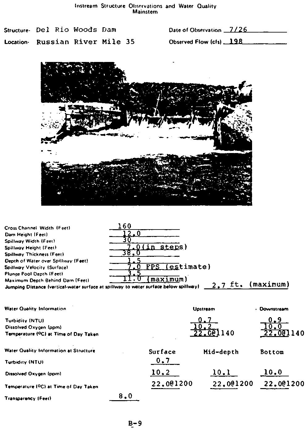
43 RUSSIAN RIVER/DRY CREEK INSTREAM STRUCTURES STRUCTURE Del Rio Woods Dam LOCATION Russian River Mile 35 (Map Ref. Pg. A-16) OWNER Del Rio Woods Recreation District PURPOSE Summer recreation dam OPERATION CONSTRUCTION Approximately Memorial Day to sometime after Labor Day Permanent "U" shaped concrete steel and wood spillway anchored in the center of the channel. Gravel dikes constructed in the spring on either side of the permanent structure divert the channel flow over the spillway. FISH PASSAGE None available when dam is in place. During the winter the river flows around each side of the permanent structure. REFERENCES Schultz, 1976 Morrison, 1978 Harris, 1974 B-8
44
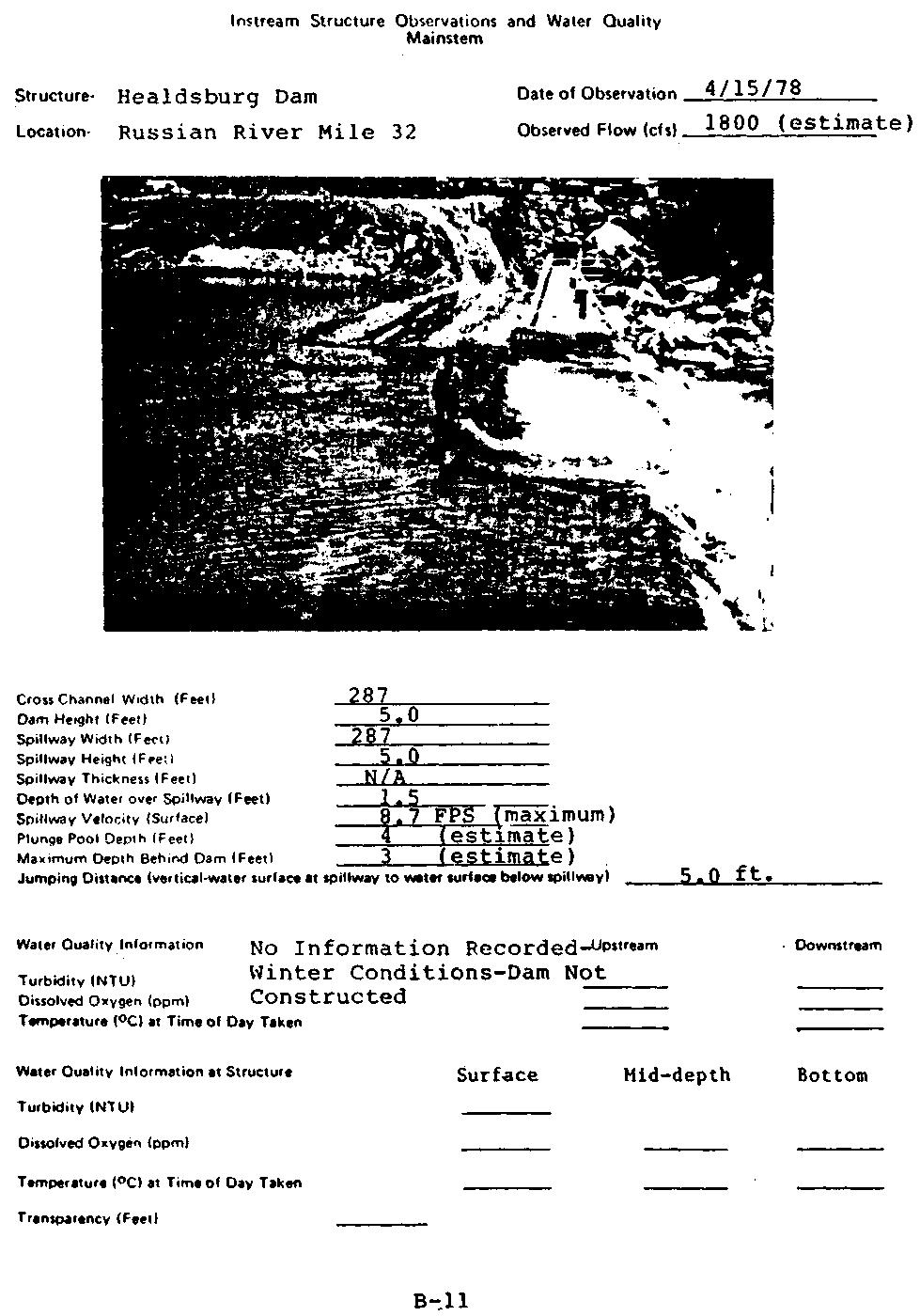
45 RUSSIAN RIVER/DRY CREEK INSTREAM STRUCTURES STRUCTURE Healdsburg Dam (War Memorial Dam) LOCATION Russian River Mile 32 (Map Ref. Pg. A-16) OWNER PURPOSE Sonoma County Regional Parks and Recreation District Summer recreation dam OPERATION CONSTRUCTION Approximately Memorial Day to sometime after Labor Day Permanent concrete sill with wooden floodgates or flashboards which are raised each spring and supported by steel I-beams. FISH PASSAGE None available - only passage is to jump the concrete dam. Total barrier when flashboards are in place. REFERENCES Schultz, 1976 Morrison, 1978 Harris, 1974 B-10
46
47
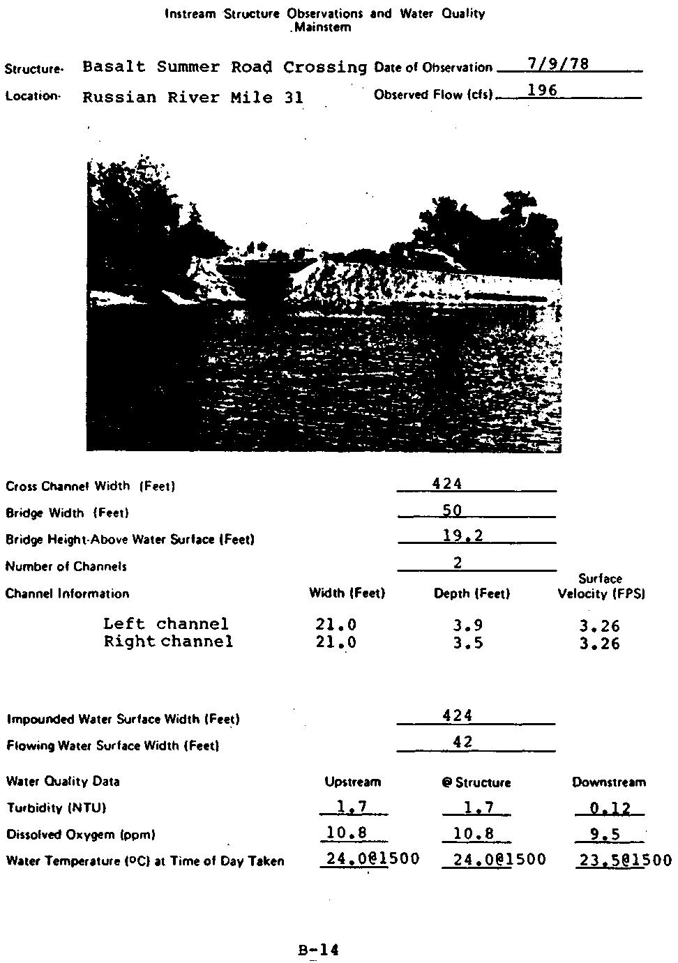
48 RUSSIAN RIVER/DRY CREEK INSTREAM STRUCTURES STRUCTURE Basalt Summer Road Crossing LOCATION Russian River Mile 31 (Map Ref. Pg. A-16) OWNER Basalt Company PURPOSE Summer road crossing OPERATION CONSTRUCTION Approximately Memorial Day to sometime after Labor Day Permanent concrete abutments on the left side of the river (looking downstream). Gravel road constructed each year channels the river between the abutments. FISH PASSAGE Channel between the abutments. REFERENCES U.S. Army Corps of Engineers aerial photos B-l3
49
50 RUSSIAN RIVER/DRY CREEK INSTREAM STRUCTURES STRUCTURE Two summer dams LOCATION OWNER PURPOSE Russian River Mile 23 (just above Wohler Bridge) (Map Ref. Pg. A-20) No longer in operation after construction of Wohler Dam Unknown OPERATION Unknown CONSTRUCTION Appeared to be gravel dams with narrow wooden spillways. FISH PASSAGE Unknown REFERENCES U.S. Army Corps of Engineers aerial photos B-15
51 RUSSIAN RIVER/DRY CREEK INSTREAM STRUCTURES STRUCTURE Wohler Dam LOCATION Russian River Mile 23 (Map Ref. Pg. A-20) OWNER Sonoma County Water Agency PURPOSE OPERATION Utility - water diversion dam for irrigation and municipal water use Approximately Memorial Day through Labor Day CONSTRUCTION Permanent concrete sill with an inflatable dam. FISH PASSAGE Two denil fishways are in permanently, one on each side. REFERENCES Schultz, 1976 Morrison, 1978 B-16

52
53 RUSSIAN RIVER/DRY CREEK INSTREAM STRUCTURES STRUCTURE Mirabel Park (old dam site) LOCATION Russian River Mile 22 (Map Ref. Pg. A-21) OWNER No longer in operation PURPOSE Old dam foundation OPERATION No longer in operation CONSTRUCTION Jagged wooden piles from an old wooden dam remain in the river. FISH PASSAGE Channels between the old wooden piles. REFERENCES Schultz, 1976 Harris, 1974 B-18

54
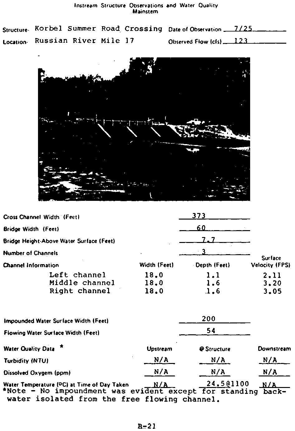
55 RUSSIAN RIVER/DRY CREEK INSTREAM STRUCTURES STRUCTURE Korbel Summer Road Crossing LOCATION Russian River Mile 17 (Map Ref. Pg. A-23) OWNER Sonoma County Public Works Department PURPOSE Summer road crossing OPERATION Approximately May 15 to October 31 CONSTRUCTION Steel piles were driven 30 feet into bedrock and four 8-foot high concrete piers were constructed as permanent instream structures. Three 20-foot steel spans are laid across the piers each year and a gravel dike is built out to the structure, thus diverting the river to a flow between the piers. FISH PASSAGE Consists of the channels formed between the permanent concrete piers. REFERENCES Robertson, 1978 B-20
56
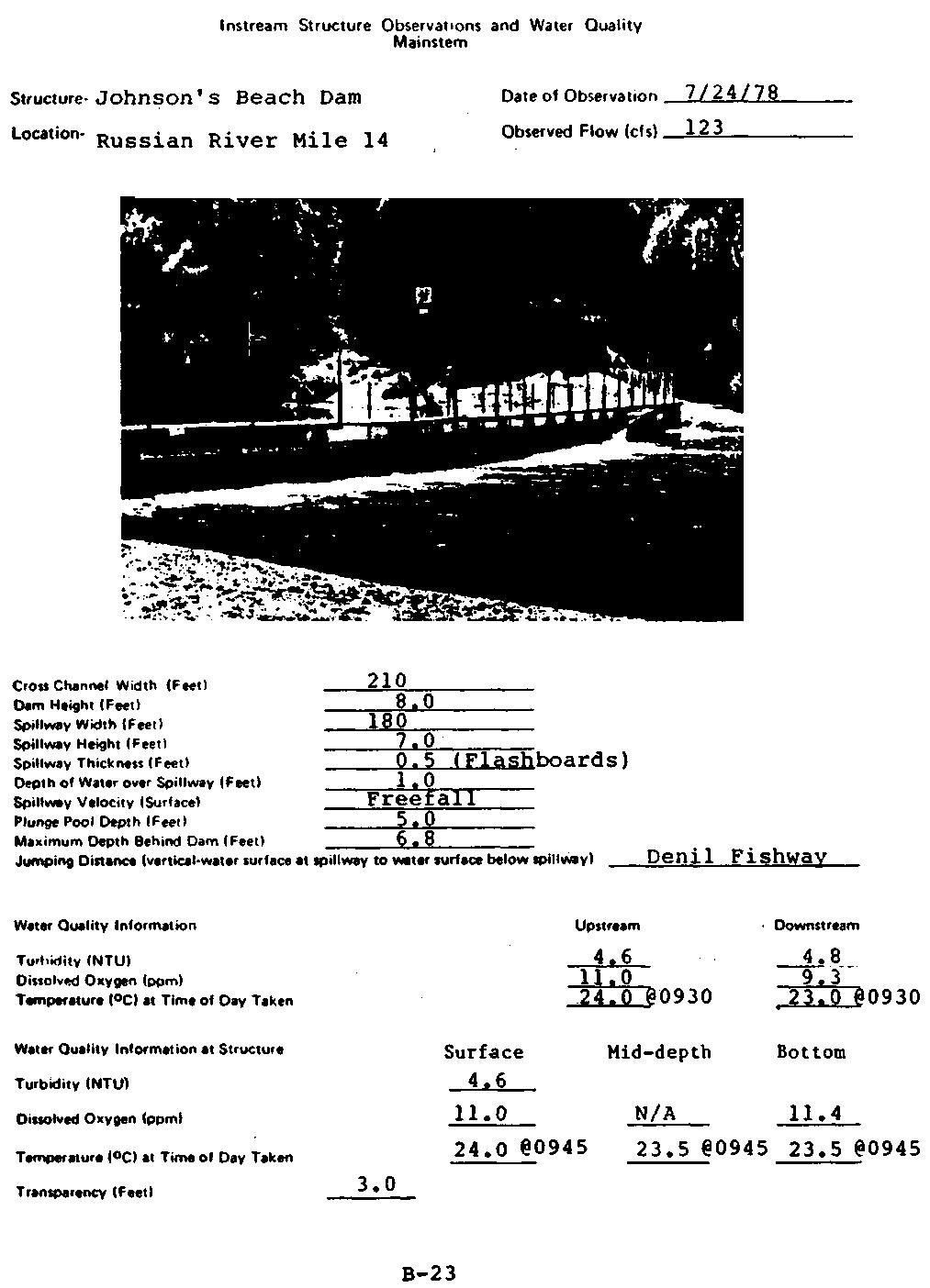
57 RUSSIAN RIVER/DRY CREEK INSTREAM STRUCTURES STRUCTURE Johnson's Beach Dam LOCATION Russian River Mile 14 (Map Ref. Pg. A-24) OWNER Russian River Parks and Recreation District PURPOSE Recreational summer dam OPERATION CONSTRUCTION Approximately Memorial Day to sometime after Labor Day. Consists of permanent concrete piers across the river. Wooden flashboards are slid into place between the piers in May and gravel dikes are built up to channel the river over the spillway. FISH PASSAGE A denil fishway was installed in 1973 and modified in 1975 to reduce fishway velocities by reducing the slope. REFERENCES Schultz, 1976 Morrison, 1978 California Department of Fish and Game, 1978c Robertson, 1978 Harris, 1974 B-22
58
59 RUSSIAN RIVER/DRY CREEK INSTREAM STRUCTURES STRUCTURE Guernewood Summer Road Crossing LOCATION Russian River Mile 13 (Map Ref. Pg. A-25) OWNER Sonoma County Public Works Department PURPOSE Summer road crossing OPERATION Approximately Memorial Day through October. Allowed to wash out with high winter flows. CONSTRUCTION Consists of six permanent wood pilings approximately 20 feet high and 20 feet apart on the left side of the channel. A gravel dike constructed in May blocks off the remaining river channel. FISH PASSAGE Consists of the channels between the wooden piers. REFERENCES Robertson, 1978 B-24
60
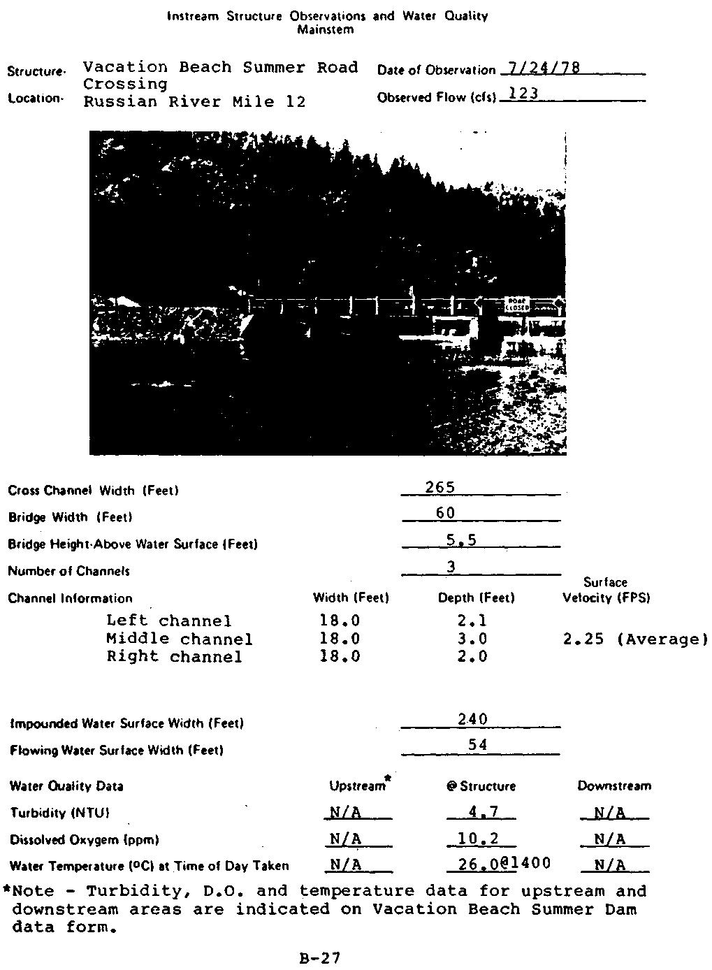
61 RUSSIAN RIVER/DRY CREEK INSTREAM STRUCTURES STRUCTURE Vacation Beach Road Crossing LOCATION Russian River Mile 12 (Map Ref. Pg. A-25) OWNER Sonoma County Road Department PURPOSE Summer road crossing OPERATION Approximately Memorial Day to end of October CONSTRUCTION Crossing consists of steel piles driven 30 feet into bedrock with four permanent 8-foot high concrete piers on which three 20-foot steel spans are bolted during the summer. Gravel dikes are then constructed out to the structure, thus restricting river flow to the channels between the piers. FISH PASSAGE The river at the bridge is divided into three channels between the concrete piers. REFERENCES Schultz, 1976 Morrison, 1978 California Department of Fish and Game, 1978c Robertson, 1978 B-26
62
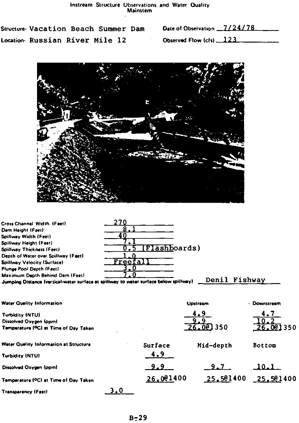
63 RUSSIAN RIVER/DRY CREEK INSTREAM STRUCTURES STRUCTURE Vacation Beach Summer Dam LOCATION Russian River Mile 12 (Map Ref. Pg. A-25) OWNER Russian River Parks and Recreation District PURPOSE Recreation OPERATION CONSTRUCTION Approximately Memorial Day to sometime after Labor Day Permanent concrete foundation with wooden flashboards on hinges that are raised and supported by steel I beams during summer months. Dam is constructed by Russian River Parks and Recreation District. FISH PASSAGE A denil fishway was installed at the dam in 1973 and modified in 1975 to reduce fishway velocities. REFERENCES Schultz, 1976 Morrison, 1978 California Department of Fish and Game, 1978c Robertson, 1978 B-28
64
65 RUSSIAN RIVER/DRY CREEK INSTREAM STRUCTURES STRUCTURE Gravel operations LOCATION Dry Creek Mile 1 near West Side Road Bridge (Map Ref. pg. A-31) OWNER Unknown PURPOSE Gravel extraction OPERATION Summer months CONSTRUCTION Removal of gravel has created deep ponds in the river channel. FISH PASSAGE None. River is completely blocked. Appears to go underground and there are large areas of barren gravel with no flow. REFERENCES U.S. Army Corps of Engineers aerial photos B-30
66 RUSSIAN RIVER/DRY CREEK INSTREAM STRUCTURES STRUCTURE Basalt Summer Crossing - Dry Creek LOCATION Dry Creek Mile 0 (Map Ref. Pg. A-17) OWNER Basalt Company PURPOSE Summer access OPERATION CONSTRUCTION Approximately Memorial Day to sometime after Labor Day Gravel dam with six culverts to allow flow. FISH PASSAGE Only through culverts REFERENCES U.S. Army Corps of Engineers aerial photos California Department of Fish and Game 1976, Form 1603-III B-31
67
68 Appendix C Fish Habitat Data for Russian River and Dry Creek Data are organized by study section and river mile and are presented for nursery and spawning habitat observations. Transect cross section profile data for the mainstem and Dry Creek are also presented. Russian River mainstem spawning habitat observations were made during the period of May 5 through May 18, Dry Creek spawning habitat observations were made during the period of April 13 through April 15 and on May 15, Maximum, minimum and average streamflow for these periods is indicated below: Gage Station Maximum Streamflow (cfs) Average Streamflow (cfs) Minimum Streamflow (cfs) Hopland Cloverdale Healdsburg Guerneville Dry Creek Russian River mainstem and Dry Creek nursery habitat observations were made during the period of July 6 through July 30, Maximum, minimum and average streamflow for this period is indicated below: Gage Station Maximum Streamflow (cfs) Average Streamflow (cfs) Minimum Streamflow (cfs) Hopland Cloverdale Healdsburg Guerneville Dry Creek 2 <1 <1
69 Fish Habitat Observations Spawning Habitat Mainstem Map Ref. Pg. A-2 Section 49 Upper Transect Lower Transect Section Length (feet) 1320 River Mite 92 Habitat Type riffle-run pool-run Water Surface Width (feet) Water Temperature ( Time of Day Taken Water Transparency (feet) Upper Transect Water Depth (Feet) at: Distance from Left Edge of Water Water Velocity (FPS) Measured 0.5 ft. Above the Substrate at: Distance from Left Edge of Water Water Velocity (FPS) Measured on the Surface at Midstream 2.33 Lower Transect Water Depth (Feet) at: N/A Distance from Left Edge of Water Water Velocity (FPS) Measured 0.5 ft. Above the Substrate at: N/A Distance from Left Edge of Water Water Velocity (FPS) Measured on the Surface at Midstream 4.31 Section Habitat This section is composed primarily of deep willow-lined run habitat. The upper transect is located just above the only example of riffle in this section. Pool/Riffle Ratio 3:1 Spawning Substrate Observations The riffle section below the upper transect contains water up to 1.5 feet in depth with good turbulence. Substrate is suitable spawning size with some larger (6 to 12 inch) material. Exposed material along the left edge of the water is suitable for spawning in selected patches. Several Juvenile steelhead were observed and collected in a riffle near the upper transect. C-1
70 Fish Habitat Observations Nursery Habitat Mainstem Map Ref. Pg. A-2 Section 49 Upper Transect Lower Transect Section Length (feet) 1320 River Mile 92 Habitat Type run-tail pool Water Surface Width (feet) Maximum Water Depth (feet) Water Temperature ( Time of Day Taken Water Transparency (feet) In-Channel Cover (feet) In-Channel Vegetative Canopy (feet) In-Stream Cover (feet) In-Stream Vegetative Canopy (feet) Water Velocity (FPS) in Midstream at the Surface (Upper Transect) 2.07 Water Velocity (FPS) in Midstream at the Surface (Lower Transect) 1.54 Section Pool Quality Pool and run habitat are good with respect to depth, cover and canopy. Substrate is typically good through the pool habitat sections. Section Riffle Quality Riffle habitat immediately below the upper transect is good with respect to depth (up to 1.5 feet) and substrate (generally spawning size material). Invertebrate abundance 100 orgamisms/ft 2. Pool/Riffle Ratio 3:1 General Section Comments Juvenile steelhead were collected at the upper transect, indicating potentially satisfactory summer nursery habitat. C-2
71
72 Fish Habitat Observations Spawning Habitat Mainstem Map Ref. Pg. A-2 Section 48 Upper Transect Lower Transect Section Length (feet) 1320 River Mile 90 Habitat Type run pool-run Water Surface Width (feet) Water Temperature ( Time of Day Taken Water Transparency (feet) Upper Transect Water Depth (Feet) at: N/A Distance from Left Edge of Water Water Velocity (FPS) Measured 0.5 ft. Above the Substrate at: N/A Distance from Left Edge of Water Water Velocity (FPS) Measured on the Surface at Midstream 1.83 Lower Transect Water Depth (Feet) at: 0.25 N/A 0.5 N/A 0.75 N/A Distance from Left Edge of Water Water Velocity (FPS) Measured 0.5 ft. Above the Substrate at: 0.25 N/A. 0.5 N/A 0.75 N/A Distance from Left Edge of Water Water Velocity (FPS) Measured on the Surface at Midstream 3.28 Section Habitat Section is composed of pool and deep run habitat. Pool/Riffle Ratio 100% pool Spawning Substrate Observations Very little spawning habitat is available in this section. Just above the upper transect a pool tail is located with potentially usable spawning substrate. Communication with a local fisherman indicated the presence of yearling salmonids in the pool at the lower transect. C-4
73 Fish Habitat Observations Nursery Habitat Mainstem Map Ref. Pg. A-2 Section 48 Upper Transect Lower Transect Section Length (feet) 1320 River Mile 90 Habitat Type run pool Water Surface Width (feet) Maximum Water Depth (feet) Water Temperature ( Time of Day Taken Water Transparency (feet) In-Channel Cover (feet) 7 16 In-Channel Vegetative Canopy (feet) 23 0 In-Stream Cover (feet) 17 1 In-Stream Vegetative Canopy (feet) 28 0 Water Velocity (FPS) in Midstream at the Surface (Upper Transect) 4.92 Water Velocity (FPS) in Midstream at the Surface (Lower Transect) 1.03 Section Pool Quality Pool quality is very good. Much of this section contains habitat greater than 3 feet in depth. Pool substrate is generally fine material. Canopy and cover are generally available on the right edge of water through the upper half of the section and on the left edge of water through the lower half. Section Riffle Quality -- Section 48 contains no riffle habitat. Sixty invertebrates/ft 2 were discovered in the pool tail-riffle above the upper transect. Pool/Riffle Ratio 100% pool General Section Comments Section offers a considerable amount of deep canopy- and coversheltered nursery habitat. C-5
74
75 Fish Habitat Observations Spawning Habitat Mainstem Map Ref. Pg. A-2 Section 47 Upper Transect Lower Transect Section Length (feet) 2300 River Mile 89 Habitat Type run-riffle run-riffle Water Surface Width (feet) Water Temperature ( Time of Day Taken Water Transparency (feet) Upper Transect Water Depth (Feet) at: Distance from Left Edge of Water Water Velocity (FPS) Measured 0.5 ft. Above the Substrate at: Distance from Left Edge of Water Water Velocity (FPS) Measured on the Surface at Midstream 3.38 Lower Transect Water Depth (Feet) at: Distance from Left Edge of Water Water Velocity (FPS) Measured 0.5 ft. Above the Substrate at: Distance from Left Edge of Water Water Velocity (FPS) Measured on the Surface at Midstream 6.74 Section Habitat The majority of this section is a relatively deep, swift, narrow run created by an in-channel gravel operation. A levee constructed to isolate their work is responsible for the river channelization. Short sections of riffle and pool habitat are available above and below the long run section. Pool/Riffle Ratio 7.2:1 Spawning Substrate Observations Two juvenile steelhead were seined from a small riffle below the lower transect. Spawning-size substrate is generally abundant at the mouth of McClure Creek during winter conditions. In addition potentially usable substrate is located at the upper and lower transects. C-7
76 Fish Habitat Observations Nursery Habitat Mainstem Map Ref. Pg. A-2 Section 47 Upper Transect Lower Transect Section Length (feet) 2300 River Mile 39 Habitat Type riffle riffle Water Surface Width (feet) Maximum Water Depth (feet) Water Temperature ( Time of Day Taken Water Transparency (feet) In-Channel Cover (feet) 7 16 In-Channel Vegetative Canopy (feet) 23 0 In-Stream Cover (feet) 17 1 In-Stream Vegetative Canopy (feet) 28 0 Water Velocity (FPS) in Midstream at the Surface (Upper Transect) 2.76 Water Velocity (FPS) in Midstream at the Surface (Lower Transect) 4.24 Section Pool Quality Runs are prevalent in this section. Pools are located near the upper transect and at the lower transect under the highway bridge. Cover and canopy are very good at each pool location. Maximum depths exceeding 4 feet are available. Section Riffle Quality Riffles contain suitable spawning-size substrate and offer a range of depths and velocities. Riffles are generally scarce in this stream section and are not well shoded. Pool/Riffle Ratio 7.2:1 General Section Comments Canopy is very good on the right edge of the water adjacent to the majority of this river section (run habitat). An in-channel gravel operation has created most of this run section by constructing a levee to isolate the work. This activity constricts the flow, creating faster, deeper, run habitat. The gravel operation is located at the now-dry mouth of McClure Creek. C-8
77
78 Fish Habitat Observations Spawning Habitat Mainstem Map Ref. Pg. A-3 Section 46 Upper Transect Lower Transect Section Length (feet) 1200 River Mile 87 Habitat Type run riffle-run Water Surface Width (feet) Water Temperature ( Time of Day Taken Water Transparency (feet) Upper Transect Water Depth (Feet) at: 0.25 N/A 0.5 N/A 0.75 N/A Distance from Left Edge of Water Water Velocity (FPS) Measured 0.5 ft. Above the Substrate at: 0.25 N/A 0.5 N/A 0.75 N/A Distance from Left Edge of Water Water Velocity (FPS) Measured on the Surface at Midstream 3.93 Lower Transect Water Depth (Feet) at: 0.25 N/A 0.5 N/A 0.75 N/A Distance from Left Edge of Water Velocity (FPS) Measured 0.5 ft. Above Water the Substrate at: 0.25 N /A 0.5 N/A 0.75 N/A Distance from Left Edge of Water Velocity (FPS) Measured on the Surface Water at Midstream 4.70 Section Habitat The majority of this section is composed of run habitat with maximum depths greater than 5 feet. Both banks are heavily lined with willow and other riparian vegetation. A stretch of riffle habitat is located at and just above the lower transect. Pool/Riffle Ratio 2.1:1 S Spawning Substrate Observations Riffle section at the lower transect is relatively swift and deep (depth 1 to 3 feet). Substrate is suitable spawningsize material. Elsewhere, very little spawning substrate is available in this section except for a minor amount of exposed material on the gravel bar at the upper transect. C-10
79 Fish Habitat Observations Nursery Habitat Mainstem Map Ref. Pg. A-3 Section 46 Upper Transect Lower Transect Section Length (feet) 1200 River Mile 87 Habitat Type run riffle Water Surface Width (feet) Maximum Water Depth (feet) Water Temperature ( Time of Day Taken Water Transparency (feet) In-Channel Cover (feet) In-Channel Vegetative Canopy (feet) In-Stream Cover (feet) 1 3 In-Stream Vegetative Canopy (feet) Water Velocity (FPS) in Midstream at the Surface (Upper Transect) 2.76 Water Velocity (FPS) in Midstream at the Surface (Lower Transect) 4.70 Section Pool Quality The majority of this section is run habitat with the exception of one riffle stretch above the lower transect. Runs are generally well shaded and depths exceeding 5 feet are available. Section Riffle Quality Riffle habitat at the lower transect contains suitable spawning size substrate. In addition, canopy and cover are very good. Depths extend to 3 feet and velocities in the main flow reach a relatively swift 4.70 fps. Pool/Riffle Ratio 2.1:1 General Section Comments This section is the most uniform example encountered of run habitat extending practically the length of a stream section. It is also significant in that it contains the greatest amount of riparian vegetation encountered in any sample section. This section is adjacent the Ukiah City Sewage Treatment Plant. C-11
80
81 Fish Habitat Observations Spawning Habitat Mainstem Map Ref. Pg. A-4 Section 44 Upper Transect Lower Transect Section Length (feet) 800 River Mile 84 Habitat Type pool run run Water Surface Width (feet) Water Temperature ( Time of Day Taken Water Transparency (feet) Upper Transect Water Depth (Feet) at: 0.25 N/A 0.5 N/A 0.75 N/A Distance from Left Edge of Water Water Velocity (FPS) Measured 0.5 ft. Above the Substrate at: 0.25 N/A 0.5 N/A 0.75 N/A Distance from Left Edge of Water Water Velocity (FPS) Measured on the Surface at Midstream 4.92 Lower Transect Water Depth (Feet) at: Distance from Left Edge of Water Water Velocity (FPS) Measured 0.5 ft. Above the Substrate at: Distance from Left Edge of Water Water Velocity (FPS) Measured on the Surface at Midstream 2.51 Section Habitat The McDonald Creek confluence is at the upper transect; approximately 1 cfs is flowing in McDonald Creek. At the upper transect is pool habitat; run habitat is below the upper transect extending downstream to the riffle at the lower transect. Pool/Riffle Ratio 4.2:1 Spawning Substrate Observations Young of the year salmonids were observed at the McDonald Creek confluence in May. Very good spawning substrate is available at the Creek confluence. Potentially usable substrate is also located at the lower transect and on the in-channel island exposed midway in the section. C-13
82 Fish Habitat Observations Nursery Habitat Mainstem Map Ref. Pg. A-4 Section 44 Upper Transect Lower Transect Section Length (feet) 800 River Mile 84 Habitat Type pool riffle Water Surface Width (feet) Maximum Water Depth (feet) Water Temperature ( Time of Day Taken Water Transparency (feet) In-Channel Cover (feet) In-Channel Vegetative Canopy (feet) In-Stream Cover (feet) 0 2 In-Stream Vegetative Canopy (feet) 0 15 Water Velocity (FPS) in Midstream at the Surface (Upper Transect) 2.11 Water Velocity (FPS) in Midstream at the Surface (Lower Transect) 3.16 Section Pool Quality The only pool habitat in this section is located at the upper transect. A maximum depth of 6 feet is available in the pool. Very little shading is provided at the observed flow. A stretch of run extends most of the length of this section. Depths are fair and shading is good on the left edge of water. Section Riffle Quality The riffle stretch at the lower transect contains primarily good substrate suitable for spawning, although the concentration of fine material is relatively high. Sixty invertebrates/ft2 were discovered on this riffle. Pool/Riffle Ratio 4.2:1 General Section Comments The upper transect is located at the mouth of McDonald Creek. Juvenile salmonids were observed in May. There was no sign of salmonids in July. C-14
83
84 Fish Habitat Observations Spawning Habitat Mainstem Map Ref. Pg. A-5 Section 43 Upper Transect Lower Transect Section Length (feet) 1500 River Mile 81 Habitat Type run run Water Surface Width (feet) Water Temperature ( Time of Day Taken Water Transparency (feet) Upper Transect Water Depth (Feet) at: 0.25 N/A 0.5 N/A Distance from Left Edge of Water Water Velocity (FPS) Measured 0.5 ft. Above the Substrate at: 0.25 N/A 0.5 N/A Distance from Left Edge of Water Water Velocity (FPS) Measured on the Surface at Midstream 4.52 Lower Transect Water Depth (Feet) at: 0.25 N/A 0.5 N/A 0.75 N/A Distance from Left Edge of Water Water Velocity (FPS) Measured 0.5 ft. Above the Substrate at: 0.25 N/A 0.5 N/A 0.75 N/A Distance from Left Edge of Water Water Velocity (FPS) Measured on the Surface at Midstream 3.20 Section Habitat The entire stream section is a relatively deep run with very good riparian cover and canopy on the left edge of the water. Pool/Riffle Ratio 100% pool Spawning Substrate Observations Instream spawning substrate is poor at the observed flow. However, the exposed gravel bar on the right edge of the water contains considerable spawning substrate that would be potentially usable at higher flows. C-16
85 Fish Habitat Observations Nursery Habitat Mainstem Map Ref. Pg. A-5 Section 43 Upper Transect Lower Transect Section Length (feet) 1500 River Mile 81 Habitat Type run run-tail Water Surface Width (feet) Maximum Water Depth (feet) Water Temperature ( Time of Day Taken Water Transparency (feet) In-Channel Cover (feet) In-Channel Vegetative Canopy (feet) In-Stream Cover (feet) 5 3 In-Stream Vegetative Canopy (feet) Water Velocity (FPS) in Midstream at the Surface (Upper Transect) 4.06 Water Velocity (FPS) in Midstream at the Surface (Lower Transect) 2.91 Section Pool Quality Entire section consists of deep run habitat. Depths are generally greater than 2.5 feet adjacent to the bank on the left edge of the water. Section Riffle Quality Section contains no riffle habitat Pool/Riffle Ratio 100% pool General Section Comments The section consists of deep run habitat with good left edge riparian cover and canopy. Section water surface width is relatively narrow, providing relatively deep moving water with less surface exposure than usual. C-17
86
87 Fish Habitat Observations Spawning Habitat Mainstem Map Ref. Pg. A-6 Section 41 Upper Transect Lower Transect Section Length (feet) 825 River Mite 78 Habitat Type riffle run Water Surface Width (feet) Water Temperature ( Time of Day Taken Water Transparency (feet) Upper Transect Water Depth (Feet) at: Distance from Left Edge of Water Water Velocity (FPS) Measured 0.5 ft. Above the Substrate at: Distance from Left Edge of Water Water Velocity 7 (FPS) Measured on the Surface at Midstream 7.11 Lower Transect Water Depth (Feet) at: 0.25 N/A 0.5 N/A 0.75 N/A Distance from Left Edge of Water Water Velocity (FPS) Measured 0.5 ft. Above the Substrate at: 0.25 N/A 0.5 N/A 0.75 N/A Distance from Left Edge of Water Water Velocity (FPS) Measured on the Surface at Midstream 4.41 Section Habitat The section is composed primarily of deep runs with one stretch of riffle at and just below the upper transect. Pool/Riffle Ratio 2.8:1 Spawning Substrate Observations The riffle at the upper transect and the pool tail immediately above the upper transect provide very good, clean, spawning-size substrate. Pockets of exposed suitable size substrate are available at the gravel bar near the left edge of the water. C-19
88 Fish Habitat Observations Nursery Habitat Mainstem Map Ref. Pg. A-6 Section 41 Upper Transect Lower Transect Section Length (feet) 825 River Mile 78 Habitat Type pool tail run Water Surface Width (feet) Maximum Water Depth (feet) Water Temperature ( Time of Day Taken Water Transparency (feet) In-Channel Cover (feet) 3 8 In-Channel Vegetative Canopy (feet) In-Stream Cover (feet) 7 0 In-Stream Vegetative Canopy (feet) 0 0 Water Velocity (FPS) in Midstream at the Surface (Upper Transect) 1.83 Water Velocity (FPS) in Midstream at the Surface (Lower Transect) 2.40 Section Pool Quality Non-riffle habitat is mostly run habitat in this stream section. Runs are deep (4.0 feet maximum depth) and provide good instream cover consisting of submerged branches and rip-rap. Section Riffle Quality The one riffle in this section is located Just below the upper transect. Depths are on the shallow side (1.0 feet), although limited deep habitat is available. Substrate is optimal salmonid spawning material. Pool/Riffle Ratio 2.8:1 General Section Comments Section contains good, deep run habitat. C-20
89
90 Fish Habitat Observation Spawning Habitat Mainstem Map Ref. Pg. A-7 Section 40 Upper Transect Lower Transect Section Length (feet) 730 River Mite 75 Habitat Type riffle-run run Water Surface Width (feet) Water Temperature ( Time of Day Taken Water Transparency (feet) Upper Transect Water Depth (Feet) at: N/A Distance from Left Edge of Water Velocity (FPS) Measured 0.5 ft. Above Water the Substrate at: N/A Distance from Left Edge of Water Velocity (FPS) Measured on the Surface Water at Midstream 4.52 Lower Transect Water Depth (Feet) at: N/A 0.5 N/A 0.75 N/A Distance from Left Edge of Water Velocity (FPS) Measured 0.5 ft. Above Water the Substrate at: N/A 0.5 N/A 0.75 N/A Distance from Left Edge of Water Velocity (FPS) Measured on the Surface Water at Midstream 5.48 Section Habitat Section is composed of deep runs and riffles; pool habitat is absent. Pool/Riffle Ratio 2.6:1 Spawning Substrate Observations Instream spawning substrate is very good in riffle sections. Substrate is very clean with respect to content of fine material. Exposed substrate is also very good. The gravel bar on the left edge of water contains potentially usable substrate. C-22
91 Fish Habitat Observations Nursery Habitat Mainstem Map Ref. Pg. A-7 Section 40 Upper Transect Lower Transect Section Length (feet) 730 River Mile 75 Habitat Type run-tail pool-run Water Surface Width (feet) Maximum Water Depth (feet) Water Temperature ( Time of Day Taken Water Transparency (feet) In-Channel Cover (feet) In-Channel Vegetative Canopy (feet) ± In-Stream Cover (feet) 0 0 In-Stream Vegetative Canopy (feet) 3 7 Water Velocity (FPS) in Midstream at the Surface (Upper Transect) 4.42 Water Velocity (FPS) in Midstream at the Surface (Lower Transect) 2.50 Section Pool Quality Pool habitat is absent, but a considerable portion of the section is deep run. Right edge of water provides excellent riparian cover and canopy. Run sections contain very good holding water habitat. Section Riffle Quality Riffles are generally 0.5 to 2.0 feet in depth and composed of very good size spawning substrate. Canopy is available on the right edge of water. Pool/Riffle Ratio 2.6:1 General Section Comments Section provides (potentially) very good run holding habitat and riffle spawning habitat. Army Corps of Engineers "jack" lines stabilize approximately 600 feet of this section. C-23
92
93 Fish Habitat Observations Spawning Habitat Mainstem Map Ref. Pg. A-8 Section 38 Upper Transect Lower Transect Section Length (feet) 3500 River Mile 71 Habitat Type pool-run riffle Water Surface Width (feet) Water Temperature ( Time of Day Taken Water Transparency (feet) Upper Transect Water Depth (Feet) at: 0.25 N/A 0.5 N/A 0.75 N/A Distance from Left Edge of Water Water Velocity (FPS) Measured 0.5 ft. Above the Substrate at: 0.25 N/A 0.5 N/A 0.75 N/A Distance from Left Edge of Water Water Velocity (FPS) Measured on the Surface at Midstream 4.18 Lower Transect Water Depth (Feet) at: N/A Distance from Left Edge of Water Water Velocity (FPS) Measured 0.5 ft. Above the Substrate at: N/A Distance from Left Edge of Water Water Velocity (FPS) Measured on the Surface at Midstream 2.76 Section Habitat Section consists primarily of relatively deep (>2.5 feet) and shallow (<2.5 feet) run habitat with very little riffle and pool habitat. Pools are located Just below the upper transect and just above the lower transect. Riffles exist at the upper transect and midway in the section. Pool/Riffle Ratio 12.5:1 Spawning Substrate Observations Instream spawning substrate is good only at the upper transect, although velocities appear restrictive for spawning (see above data). Exposed substrate is generally sub-optimal with respect to size and is often compacted. C-25
94 Fish Habitat Observations Nursery Habitat Mainstem Map Ref. Pg. A-8 Section 38 Upper Transect Lower Transect Section Length (feet) 3500 River Mile 71 Habitat Type run run Water Surface Width (feet) Maximum Water Depth (feet) Water Temperature ( Time of Day Taken Water Transparency (feet) In-Channel Cover (feet) 7 8 In-Channel Vegetative Canopy (feet) In-Stream Cover (feet) 0 3 In-Stream Vegetative Canopy (feet) 0 0 Water Velocity (FPS) in Midstream at the Surface (Upper Transect) 6.00 Water Velocity (FPS) in Midstream at the Surface (Lower Transect) 2.15 Section Pool Quality Pool habitat is limited to two small pools near the upper and lower transects. Depth, cover and canopy are very good in each pool. Section Riffle Quality Riffle habitat is limited in this section. Riffle habitat at the upper transect is very good with respect to substrate size. Velocity is rather high due to the narrowness of the channel. The other riffle stretch in mid-section is very shallow and is composed of sub-optimal substrate. Pool/Riffle Ratio 12.5:1 General Section Comments Section contains predominantly run habitat. Quality varies depending on several variables. Considerable holding habitat with riparian protection is available in this section. C-26
95
96 Fish Habitat Observations Spawning Habitat Mainstem Map Ref. Pg. A-8 Section 37 Upper Transect Lower Transect Section Length (feet) 2520 River Mile 70 Habitat Type run pool Water Surface Width (feet) Water Temperature ( Time of Day Taken Water Transparency (feet) Upper Transect Water Depth (Feet) at: N/A 0.75 N/A Distance from Left Edge of Water Water Velocity (FPS) Measured 0.5 ft. Above the Substrate at: N/A 0.75 N/A Distance from Left Edge of Water Water Velocity (FPS) Measured on the Surface at Midstream 5.56 Lower Transect Water Depth (Feet) at: 0.25 N/A 0.5 N/A 0.75 N/A Distance from Left Edge of Water Water Velocity (FPS) Measured 0.5 ft. Above the Substrate at: 0.25 N/A 0.5 N/A 0.75 N/A Distance from Left Edge of Water Water Velocity (FPS) Measured on the Surface at Midstream 3.88 Section Habitat Section composed primarily of deep run, riffle, and rapids habitat. Some pool habitat is available at the lower transect. Pool/Riffle Ratio 3.8:1 Spawning Substrate Observations Instream substrate is generally larger than optimal spawningsize material. Instream substrate is typically rubble, boulders and bedrock with a high percentage of fines also. Exposed substrate is similar with the exception of a few isolated pockets of suitable spawning substrate. C-28
97 Fish Habitat Observations Nursery Habitat Mainstem Map Ref. Pg. A-8 Section 37 Upper Transect Lower Transect Section Length (feet) 2520 River Mile 70 Habitat Type riffle-run pool Water Surface Width (feet) Maximum Water Depth (feet) Water Temperature ( Time of Day Taken Water Transparency (feet) In-Channel Cover (feet) 7 35 In-Channel Vegetative Canopy (feet) In-Stream Cover (feet) 0 59 In-Stream Vegetative Canopy (feet) 5 10 Water Velocity (FPS) in Midstream at the Surface (Upper Transect) 4.20 Water Velocity (FPS) in Midstream at the Surface (Lower Transect) 2.87 Section Pool Quality Pool quality is very good at the lower transect (immediately above Squaw Rock Shoot). The majority of the transect is run, riffle, and rapids habitat. Run sections are basically deep with boulder cover on the bottom. Pool habitat at the lower transect is deep and contains instream bedrock cover. Section Riffle Quality Riffle quality good. Substrate is coarse, providing very Rood instream cover. Depths up to 1.5 feet and bank instream cover are available. Shading is fair to good. One stretch of rapids (245 feet) exists at approximately mid-section. Pool/Riffle Ratio 3.8:1 General Section Comments River begins to descend more rapidly (20-30 feet drop/mile) below this section for a short distance. C-29
98
99 Fish Habitat Observations Spawning Habitat Mainstem Map Ref. Pg. A-9 Section 36 Upper Transect Lower Transect Section Length (feet) 2250 River Mile 67 Habitat Type pool riffle Water Surface Width (feet) Water Temperature ( Time of Day Taken Water Transparency (feet) Upper Transect Water Depth (Feet) at: 0.25 N/A 0.5 N/A 0.75 N/A Distance from Left Edge of Water Water Velocity (FPS) Measured 0.5 ft. Above the Substrate at: 0.25 N/A 0.5 N/A 0.75 N/A Distance from Left Edge of Water Water Velocity (FPS) Measured on the Surface at Midstream 4.55 Lower Transect Water Depth (Feet) at: 0.25 N/A 0.5 N/A 0.75 N/A Distance from Left Edge of Water Water Velocity (FPS) Measured 0.5 ft. Above the Substrate at: 0.25 N/A 0.5 N/A 0.75 N/A Distance from Left Edge of Water Water Velocity (FPS) Measured on the Surface at Midstream 4.70 _ Section Habitat Section is composed primarily of run habitat with a few pool and riffle sections. Runs are generally slow moving and contain some deep (>2.5 feet) water near the left edge of water. Pool/Riffle Ratio 8 : 1 Spawning Substrate Observations Spawning substrate is available above the lower transect at the mouth of Cummiskey Creek. A summer ford is located immediately below the mouth of the creek. Spawning gravel is very clean at the site of the ford. C-31
100 Fish Habitat Observations Nursery Habitat Mainstem Map Ref. Pg. A-9 Section 36 Upper Transect Lower Transect Section Length (feet) 2250 River Mile 67 Habitat Type run riffle-run Water Surface Width (feet) Maximum Water Depth (feet) Water Temperature ( Time of Day Taken Water Transparency (feet) < 4.0 < 4.0 In-Channel Cover (feet) 6 1 In-Channel Vegetative Canopy (feet) In-Stream Cover (feet) 7 0 In-Stream Vegetative Canopy (feet) 0 0 Water Velocity (FPS) in Midstream at the Surface (Upper Transect) 2.40 Water Velocity (FPS) in Midstream at the Surface (Lower Transect) N/A Section Pool Quality Limited pool habitat is available in this section. The main concentration of pool habitat is located just below the upper transect. Boulders are available instream for cover and maximum depths are generally greater than 4.0 feet. Section Riffle Quality Riffle habitat is variable. A very good quality section of deep riffle (1.5 to 2 feet) exists upstream from the lower transect at the site of the summer ford. Pool/Riffle Ratio 8:1 General Section Comments The summer ford at Cummiskey Creek mouth is also the site of the best spawning habitat in this section. Good pool habitat is available upstream just below the upper transect. C-32
101
102 Fish Habitat Observations Spawning Habitat Mainstem Map Ref. Pg. A-10 Section 35 Upper Transect Lower Transect Section Length (feet) 1200 River Mile 66 Habitat Type rapids pool Water Surface Width (feet) Water Temperature ( Time of Day Taken Water Transparency (feet) Upper Transect Water Depth (Feet) at: 0.25 N/A 0.5 N/A 0.75 N/A Distance from Left Edge of Water Water Velocity (FPS) Measured 0.5 ft. Above the Substrate at: 0.25 N/A 0.5 N/A 0.75 N/A Distance from Left Edge of Water Water Velocity (FPS) Measured on the Surface at Midstream 9.04 Lower Transect Water Depth (Feet) at: 0.25 N/A 0.5 N/A 0.75 N/A Distance from Left Edge of Water Water Velocity (FPS) Measured 0.5 ft. Above the Substrate at: 0.25 N/A 0.5 N/A 0.75 N/A Distance from Left Edge of Water Water Velocity (FPS) Measured on the Surface at Midstream 3.89 Section Habitat Section is a series of pools and runs through boulders and bedrock. Pool/Riffle Ratio 6.5:1 Spawning Substrate Observations Very little spawning habitat is available. Most substrate is larger than optimal (boulders-bedrock). C-34
103 Fish Habitat Observations Nursery Habitat Mainstem Map Ref. Pg. A-10 Section 35 Upper Transect Lower Transect Section Length (feet) 1200 River Mile 66 Habitat Type rapids pool Water Surface Width (feet) Maximum Water Depth (feet) Water Temperature ( Time of Day Taken Water Transparency (feet) <4.0 <4.0 In-Channel Cover (feet) In-Channel Vegetative Canopy (feet) 0 18 In-Stream Cover (feet) In-Stream Vegetative Canopy (feet) 0 13 Water Velocity (FPS) in Midstream at the Surface (Upper Transect) 5.42 Water Velocity (FPS) in Midstream at the Surface (Lower Transect) 2.69 Section Pool Quality Pool quality is very good. Depths exceed 4 feet in most pools and an abundance of instream cover (boulders and bedrock) is present. Section Riffle Quality One stretch of rapids exists in this section. All other habitat is pool or run. Pool/Riffle Ratio 6.5:1 General Section Comments Section is composed primarily of boulder and bedrock pool and run habitat. C-35
104
105 Fish Habitat Observations Spawning Habitat Map Ref. Pg. A-10 Mainstem Section 33 Upper Transect Lower Transect Section Length (feet) 1900 River Mile 63 Habitat Type riffle pool Water Surface Width (feet) Water Temperature ( Time of Day Taken Water Transparency (feet) Upper Transect Water Depth (Feet) at: Distance from Left Edge of Water Water Velocity (FPS) Measured 0.5 ft. Above the Substrate at: Distance from Left Edge of Water Water Velocity (FPS) Measured on the Surface at Midstream 7.15 Lower Transect Water Depth (Feet) at: 0.25 N/A 0.5 N/A 0.75 N/A Distance from Left Edge of Water Water Velocity (FPS) Measured 0.5 ft. Above the Substrate at: 0.25 N/A 0.5 N/A 0.75 N/A Distance from Left Edge of Water Water Velocity (FPS) Measured on the Surface at Midstream 3.20 Section Habitat The section contains primarily run habitat with some isolated riffle, rapids and pool habitat. Pool/Riffle Ratio 9.8:1 Spawning Substrate Observations The riffle section at the upper transect contains suitable size spawning substrate. Isolated pockets of spawning gravel are available on the left exposed gravel bar, interspersed with patches of in-channel willows. C-37
106 Fish Habitat Observations Nursery Habitat Mainstem Map Ref. Pg. A-10 Section 33 Upper Transect Lower Transect Section Length (feet) 1900 River Mile 63 Habitat Type riffle pool Water Surface Width (feet) Maximum Water Depth (feet) Water Temperature ( C) 9 Time of Day Taken Water Transparency (feet) In-Channel Cover (feet) In-Channel Vegetative Canopy (feet) 66 0 In-Stream Cover (feet) 0 2 In-Stream Vegetative Canopy (feet) 0 0 Water Velocity (FPS) in Midstream at the Surface (Upper Transect) 5.71 Water Velocity (FPS) in Midstream at the Surface (Lower Transect) 1.22 Section Pool Quality Runs are predominant in this section except for a large deep pool under the Highway 101 bridge at the lower transect. Runs contain deep segments along the right bank where cover and canopy are available. Section Riffle Quality Riffles are not abundant in this section. A short shallow riffle is located at the upper transect and a section of rapids is located just above the lower transect. Pool/Riffle Ratio 9.8:1 General Section Comments Section contains a good holding stretch of run located just upstream from a section of rapids. C-38
107
108 Fish Habitat Observations Spawning Habitat Map Ref. Pg. A-11 Section 32 Upper Transect Lower Transect Section Length (feet) 620 River Mile 62 Habitat Type run riffle-run Water Surface Width (feet) Water Temperature ( Time of Day Taken Water Transparency (feet) Upper Transect Water Depth (Feet) at: N/A Distance from Left Edge of Water Water Velocity (FPS) Measured 0.5 ft. Above the Substrate at: N/A 0.75 N/A Distance from Left Edge of Water Water Velocity 1 (FPS) Measured on the Surface at Midstream 4.24.,_ Lower Transect Water Depth (Feet) at: N/A 0.75 N/A Distance from Left Edge of Water Water Velocity (FPS) Measured 0.5 ft. Above the Substrate at: N/A 0.75 N/A Distance from Left Edge of Water Water Velocity 3 (FPS) Measured on the Surface at Midstream 3.63 Section Habitat The section is composed primarily of deep runs and riffles. Pool/Riffle Ratio 3.1:1 Spawning Substrate Observations The exposed gravel bar on the left edge of water contains spawning size material. A strip approximately 100 feet wide extends the length of the transect, but the content of fine materials is very high. C-40
109 Fish Habitat Observations Nursery Habitat Mainstem Map Ref. Pg. A-11 Section 32 Upper Transect Lower Transect Section Length (feet) 620 River Mile 62 Habitat Type run riffle Water Surface Width (feet) Maximum Water Depth (feet) Water Temperature ( Time of Day Taken Water Transparency (feet) In-Channel Cover (feet) In-Channel Vegetative Canopy (feet) In-Stream Cover (feet) 7 0 In-Stream Vegetative Canopy (feet) 5 0 Water Velocity (FPS) in Midstream at the Surface (Upper Transect) 1.73 Water Velocity (FPS) in Midstream at the Surface (Lower Transect) 2.40 Section Pool Quality The section is primarily run and riffle habitat. Run quality is good; generally consisting of deep narrow runs with riparian canopy on the right edge of water only. Section Riffle Quality The riffle stretch of this section is good habitat from a depth and velocity standpoint. The substrate contains many fines and the riffle is completely exposed. Pool/Riffle Ratio 3.1:1 General Section Comments This section is opposite a large operating gravel company. C-41
110
111 Fish Habitat Observations Spawning Habitat Map Ref. Pg. A-11 Mainstem Section 31 Upper Transect Lower Transect Section Length (feet) 1320 River Mile 61 Habitat Type pool riffle-run Water Surface Width (feet) Water Temperature ( Time of Day Taken Water Transparency (feet) Upper Transect Water Depth (Feet) at: 0.25 N/A Distance from Left Edge of Water Water Velocity (FPS) Measured 0.5 ft. Above the Substrate at: 0.25 N/A Distance from Left Edge of Water Water Velocity (FPS) Measured on the Surface at Midstream 1.83 Lower Transect Water Depth (Feet) at: 0.25 N/A 0.5 N/A Distance from Left Edge of Water Water Velocity (FPS) Measured 0.5 ft. Above the Substrate at: 0.25 N/A 0.5 N/A Distance from Left Edge of Water Water Velocity (FPS) Measured on the Surface at Midstream 5.30 Section Habitat The section is composed primarily of deep, left bank runs with some riffle habitat. Pool/Riffle Ratio 0.6:1 Spawning Substrate Observations Suitable spawning substrate was observed in the pool tail just below the upper transect. Other areas observed contained too high a concentration of fine material for optimal spawning conditions. C-43
112 Fish Habitat Observations Nursery Habitat Mainstem Map Ref. Pg. A-11 Section 31 Upper Transect Lower Transect Section Length (feet) 1320 River Mile 61 Habitat Type pool riffle Water Surface Width (feet) Maximum Water Depth (feet) Water Temperature ( Time of Day Taken Water Transparency (feet) >4.0 >4.0 In-Channel Cover (feet) 63 9 In-Channel Vegetative Canopy (feet) In-Stream Cover (feet) 7 0 In-Stream Vegetative Canopy (feet) 20 2 Water Velocity (FPS) in Midstream at the Surface (Upper Transect) 1.90 Water Velocity (FPS) in Midstream at the Surface (Lower Transect) 6.52 Section Pool Quality The section contains mostly run and riffle habitat with the exception of one stretch of pool at the upper transect. Run quality is generally good; depths up to 8 feet exist along the left edge of the water. Cover and canopy are good on the left edge of the water. Section Riffle Quality Riffle quality is variable in this section primarily because of the range of riffle depths. Substrate is generally coarse material. Pool/Riffle Ratio 0.6:1 General Section Comments The section is narrow, resulting in deep, fast-moving water. Less surface area is exposed at the run and more surface area is covered by riparian vegetation. C-44
113
114 Fish Habitat Observations Spawning Habitat Mainstem Map Ref. Pg. A-12 Section 30 Upper Transect Lower Transect Section Length (feet) 820 River Mite 57 Habitat Type riffle pool-run Water Surface Width (feet) Water Temperature ( Time of Day Taken Water Transparency (feet) Upper Transect Water Depth (Feet) at: 0.25 N/A Distance from Left Edge of Water Velocity (FPS) Measured 0.5 ft. Above Water the Substrate at: 0.25 N/A Distance from Left Edge of Water Velocity (FPS) Measured on the Surface Water at Midstream 2.87 Lower Transect Water Depth (Feet) at: N/A 0.75 N/A Distance from Left Edge of Water Water 5 Velocity (FPS) Measured 0.5 ft. Above the Substrate at: N/A 0.75 N/A Distance from Left Edge of Water Water 5 Velocity (FPS) Measured on the Surface at Midstream 4.69 Section Habitat The section contains riffle, run, and pool habitat. The main flowing channel is against bedrock on the right edge of the river channel. Pool/Riffle Ratio 0.6:1 Spawning Substrate Observations Spawning habitat is suitable in riffle stretches of this section from a substrate size standpoint. Exposed gravel bar substrate on the left edge of the water is also of suitable spawning size. C-46
115 Fish Habitat Observations Nursery Habitat Mainstem Map Ref. Pg. A-12 Section 30 Upper Transect Lower Transect Section Length (feet) 1320 River Mile 57 Habitat Type N/A pool-run Water Surface Width (feet) N/A split channel lt.-20 rt.-81 (main chnl.) rt.-2.2 lt.-4.0 Maximum Water Depth (feet) N/A Water Temperature ( Time of Day Taken N/A 1015 Water Transparency (feet) N/A 4.0 In-Channel Cover (feet) N/A 45 In-Channel Vegetative Canopy (feet) N/A 35 In-Stream Cover (feet) N/A 23 In-Stream Vegetative Canopy (feet) N/A 9 Water Velocity (FPS) in Midstream at the Surface (Upper Transect) Water Velocity (FPS) in Midstream at the Surface (Lower Transect) N/A lt rt Section Pool Quality The pool section at the lower transect contains good habitat with respect to depth and bedrock cover on the right edge of the water. Section Riffle Quality Riffle quality is good. Substrate is suitable for spawning and relatively free of fine material. Forty invertebrates/ft2 of riffle substrate were found. Pool/Riffle Ratio 0.6:1 General Section Comments The upper transect was eliminated because the transect was disturbed by construction of the summer Asti road crossing. C-47
116
117 Fish Habitat Observations Spawning Habitat Mainstem Map Ref. Pg. A-13 Section 29 Upper Transect Lower Transect Section Length (feet) 3000 River Mile 53 Habitat Type pool tail riffle-run Water Surface Width (feet) Water Temperature ( Time of Day Taken Water Transparency (feet) Upper Transect Water Depth (Feet) at: Distance from Left Edge of Water Water Velocity (FPS) Measured 0.5 ft. Above the Substrate at: Distance from Left Edge of Water Water Velocity (FPS) Measured on the Surface at Midstream 3.26 Lower Transect Water Depth (Feet) at: 0.2 N/A 0.5 N/A 0.75 N/A Distance from Left Edge of Water Water 5 Velocity (FPS) Measured 0.5 ft. Above the Substrate at: N/A 0.5 N/A 0 N/A Distance from Left Edge of Water Water Velocity (FPS) Measured. on the Surface at Midstream 4.50 Section Habitat Runs and riffles are predominant in this section. Depth and velocity are good. The channel is very exposed. The section is opposite one of the larger mainstem gravel extraction operations. Pool/Riffle Ratio 3.4:1 Spawning Substrate Observations Riffles contain generally good spawning habitat in this section. The substrate is clean and of suitable spawning size. A wide expanse of exposed substrate exists at this section. The majority of it contains too great a percentage of fines or is compacted. C-49
118 Fish Habitat Observations Nursery Habitat Map Ref. Pg. A-13 Mainstem Section 29 Upper Transect Lower Transect Section Length (feet) 3000 River Mile 53 Habitat Type riffle run Water Surface Width (feet) Maximum Water Depth (feet) Water Temperature ( Time of Day Taken Water Transparency (feet) > 4.0 >4.0 In-Channel Cover (feet) 22 8 In-Channel Vegetative Canopy (feet) In-Stream Cover (feet) 2 8 In-Stream Vegetative Canopy (feet) 2 6 Water Velocity (FPS) in Midstream at the Surface (Upper Transect) 4.20 Water Velocity (FPS) in Midstream at the Surface (Lower Transect) 1.83 Section Pool Quality Pool quality is good. Depths are up to 3 feet, velocity and turbulence are fairly good and the substrate is mostly coarse material. Runs are more abundant than pools in this section. Section Riffle Quality Riffles are generally good quality with clean substrate. Exposure is excessive. Pool/Riffle Ratio 3.4:1 General Section Comments The water surface is exposed in this section. The section is opposite a large gravel extraction operation. C-50
119
120 Fish Habitat Observations Spawning Habitat Mainstem Map Ref. Pg. A-13 Section 28 Upper Transect Lower Transect Section Length (feet) 1860 River Mile 52 Habitat Type run run Water Surface Width (feet) Water Temperature ( Time of Day Taken Water Transparency (feet) Upper Transect Water Depth (Feet) at: 0.25 N/A 0.5 N/A 0.75 N/A Distance from Left Edge of Water Water Velocity (FPS) Measured 0.5 ft. Above the Substrate at: 0.25 N/A 0.5 N/A 0.75 N/A Distance from Left Edge of Water Water Velocity (FPS) Measured on the Surface at Midstream 2.66 Lower Transect Water Depth (Feet) at: 0.25 N/A 0.5 N/A 0.75 N/A Distance from Left Edge of Water Water Velocity (FPS) Measured 0.5 ft. Above the Substrate at: 0.25 N/A 0.5 N/A 0.75 N/A Distance from Left Edge of Water Water Velocity (FPS) Measured on the Surface at Midstream 4.31 _ Section Habitat The section is composed of run and deep riffle habitat. Little pool habitat is available. Depth through most of the section is good (30% of section is greater than 2.5 feet deep). Pool/Riffle Ratio 2.4:1 Spawning Substrate Observations Very good spawning habitat is located under the highway bridge in the wet channel. Exposed substrate under the highway bridge is very good King Salmon spawning substrate. Most exposed substrate is severely altered by gravel extraction. C-52
121 Fish Habitat Observations Nursery Habitat Mainstem Map Ref. Pg. A-13 Section 28 Upper Transect Lower Transect Section Length (feet) 1860 River Mile 52 Habitat Type pool-run riffle Water Surface Width (feet) 12A 50 Maximum Water Depth (feet) Water Temperature ( Time of Day Taken Water Transparency (feet) >4.0 >4.0 In-Channel Cover (feet) 47 6 In-Channel Vegetative Canopy (feet) In-Stream Cover (feet) 4 6 In-Stream Vegetative Canopy (feet) 0 3 Water Velocity (FPS) in Midstream at the Surface (Upper Transect) 1.31 Water Velocity (FPS) in Midstream at the Surface (Lower Transect) 2.80 Section Pool Quality Pool habitat is isolated in this section below the upper transect and just above the lower transect. Depths are good but exposure is poor. Instream cover is fair and little shading is available. Section Riffle Quality Very good riffle habitat is located below the upper transect under the highway bridge. Depths of 0.5 to 4.0 feet are available. Substrate up to 12 inches is available. Pool/Riffle Ratio 2.4:1 General Section Comments A very extensive gravel operation exists on the right side of the channel. Mass excavation on one extensive plane is progressing downstream from just below the highway bridge. C-53
122
123 Fish Habitat Observations Spawning Habitat Mainstem Map Ref. Pg. A-14 Section 27 Upper Transect Lower Transect Section Length (feet) 2000 River Mile 49 Habitat Type pool tail riffle Water Surface Width (feet) Water Temperature ( Time of Day Taken Water Transparency (feet) Upper Transect Water Depth (Feet) at: Distance from Left Edge of Water Water Velocity (FPS) Measured 0.5 ft. Above the Substrate at: Distance from Left Edge of Water Water Velocity (FPS) Measured on the Surface at Midstream 2.78 Lower Transect Water Depth (Feet) at: N/A Distance from Left Edge of Water Water Velocity (FPS) Measured 0.5 ft. Above the Substrate at: N/A Distance from Left Edge of Water Water Velocity (FPS) Measured on the Surface at Midstream 6.14 Section Habitat The channel is wide and generally exposed. The upper third of the section is run habitat consisting of shallow water with fine substrate. The lower two thirds of the section is riffle and pool habitat. Pool/Riffle Ratio 3.7:1 Spawning Substrate Observations Very good spawning habitat (riffle) is located midway in the section. In addition, the exposed substrate on the left edge of the channel contains considerable clean spawning-size material. C-55
124 Fish Habitat Observations Nursery Habitat Mainstem Map Ref. Pg. A-14 Section 27 Upper Transect Lower Transect Section Length (feet) 2000 River Mile 49 Habitat Type pool tail run Water Surface Width (feet) Maximum Water Depth (feet) Water Temperature ( Time of Day Taken Water Transparency (feet) >4.0 >4.0 In-Channel Cover (feet) 3 21 In-Channel Vegetative Canopy (feet) 5 25 In-Stream Cover (feet) 0 2 In-Stream Vegetative Canopy (feet) 0 0 Water Velocity (FPS) in Midstream at the Surface (Upper Transect) 1.43 Water Velocity (FPS) in Midstream at the Surface (Lower Transect) 1.15 Section Pool Quality Pool habitat is good near the lower transect. Considerable instream cover (branches, tree trunks) is available, but the canopy is mostly poor. Pool habitat is lacking elsewhere in this section. Section Riffle Quality Riffle quality is good. Depths extend to 1.5 feet; turbulence cover is good; and substrate is coarse (4-8 inches). No cover or canopy is available. The benthic invertebrate count is 36 individuals/ft 2. Pool/Riffle Ratio 3.7:1 General Section Comments The section is very exposed. Good spawning gravel is available. Limited deep pool habitat is available. C-56
125
126 Fish Habitat Observations Spawning Habitat Mainstem Map Ref. Pg. A-14, A-15 Section 26 Upper Transect Lower Transect Section Length (feet) 1800 River Mile 46 Habitat Type run run Water Surface Width (feet) Water Temperature ( Time of Day Taken Water Transparency (feet) Upper Transect Water Depth (Feet) at: 0.25 N/A 0.5 N/A 0.75 N/A Distance from Left Edge of Water Water Velocity (FPS) Measured 0.5 ft. Above the Substrate at: 0.25 N/A 0.5 N/A 0.75 N/A Distance from Left Edge of Water Water Velocity (FPS) Measured on the Surface at Midstream 5.64 Lower Transect Water Depth (Feet) at: 0.25 N/A Distance from Left Edge of Water Water Velocity (FPS) Measured 0.5 ft. Above the Substrate at: 0.25 N/A Distance from Left Edge of Water Water Velocity (FPS) Measured on the Surface at Midstream 1.83 Section Habitat This section contains very good pool and riffle habitat. Cover and canopy are present. Three main spawning riffles exist in this section. Pool/Riffle Ratio 1.8:1 Spawning Substrate Observations Very good spawning habitat is available in this section. Approximately 70% of this section is available for spawning from a substrate standpoint. C-58
127 Fish Habitat Observations Nursery Habitat Mainstem Map Ref. Pg. A-14, A-15 Section 26 Upper Transect Lower Transect Section Length (feet) 1800 River Mile 46 Habitat Type riffle-run pool Water Surface Width (feet) Maximum Water Depth (feet) Water Temperature ( Time of Day Taken Water Transparency (feet) >4.0 >4.0 In-Channel Cover (feet) In-Channel Vegetative Canopy (feet) In-Stream Cover (feet) 0 15 In-Stream Vegetative Canopy (feet) 0 15 Water Velocity (FPS) in Midstream at the Surface (Upper Transect) 1.90 Water Velocity (FPS) in Midstream at the Surface (Lower Transect) 2.40 Section Pool Quality Pool quality is very good. Depths up to 8 to 10 ft, undercut banks, submerged willow trunks, and good canopy are present in this section. Section Riffle Quality Riffle habitat is very good. The substrate is of spawning size and relatively free of fine material. Good riffle depth and velocity are present. Pool/Riffle Ratio 1.8:1 General Section Comments This section contained the best pool and riffle habitat observed from the mouth upstream to this point. Large (2 ft long) squawfish (Ptychocheilus grandis) were observed. C-59
128
129 Fish Habitat Observations Spawning Habitat Mainstem Map Ref. Pg. A-15 Section 22 Upper Transect Lower Transect Section Length (feet) 1000 River Mile 36 Habitat Type riffle riffle-run Water Surface Width (feet) Water Temperature ( Time of Day Taken Water Transparency (feet) Upper Transect Water Depth (Feet) at: N/A Distance from Left Edge of Water Water Velocity (FPS) Measured 0.5 ft. Above the Substrate at: N/A Distance from Left Edge of Water Water Velocity (FPS) Measured on the Surface at Midstream 6.46 Lower Transect Water Depth (Feet) at: 0.25 N/A 0.5 N/A 0.75 N/A Distance from Left Edge of Water Water Velocity (FPS) Measured 0.5 ft. Above the Substrate at: 0.25 N/A 0.5 N/A 0.75 N/A Distance from Left Edge of Water Water Velocity (FPS) Measured on the Surface at Midstream 5.02 Section Habitat The section is composed primarily of run and riffle habitat. The upper transect is riffle-run habitat. Sections of run and riffle habitat exist between the transects. The lower transect is run habitat. Pool/Riffle Ratio 2.3:1 Spawning Substrate Observations Instream substrate is suitable in patches at the upper and lower transects. The riffle section just above the lower transect contains potentially usable substrate. Isolated, exposed pockets of spawning gravel exist on the left bank at the lower transect. C-61
130 Fish Habitat Observations Nursery Habitat Mainstem Map Ref. Pg. A-15 Lower Transect Section 22 Upper Transect Section Length (feet) 1000 River Mile 36 Habitat Type pool-run riffle-run Water Surface Width (feet) Maximum Water Depth (feet) Water Temperature ( Time of Day Taken Water Transparency (feet) >4.0 >4.0 In-Channel Cover (feet) In-Channel Vegetative Canopy (feet) In-Stream Cover (feet) 6 6 In-Stream Vegetative Canopy (feet) 25 8 Water Velocity (FPS) in Midstream at the Surface (Upper Transect) 0.82 Water Velocity (FPS) in Midstream at the Surface (Lower Transect) 2.43 Section Pool Quality The section is primarily run habitat. Good riparian cover exists on both banks. Some deep (2.5 feet) slots are available near the edges of the water. The lower half of the section is more exposed than the upper half. Section Riffle Quality Riffle habitat is good. Depths are available up to 1.5 feet; the water surface is turbulent and the substrate is coarse (to 12 inches). Shading is available on the banks. Pool/Riffle Ratio 2.3:1 General Section Comments Substrate through the run stretches is generally fine and poor with respect to invertebrate abundance. The section is narrow compared to most sections. C-62
131
132 Fish Habitat Observations Spawning Habitat Mainstem Map Ref. Pg. A-16 Section 21 Upper Transect Lower Transect Section Length (feet) 750 River Mile 34 Habitat Type riffle-run Pool-tail Water Surface Width (feet) Water Temperature ( Time of Day Taken Water Transparency (feet) Upper Transect Water Depth (Feet) at: 0.25 N/A Distance from Left Edge of Water Water Velocity (FPS) Measured 0.5 ft. Above the Substrate at: 0.25 N/A Distance from Left Edge of Water Water Velocity (FPS) Measured on the Surface at Midstream 1.43 Lower Transect Water Depth (Feet) at: Distance from Left Edge of Water Water Velocity (FPS) Measured 0.5 ft. Above the Substrate at: Distance from Left Edge of Water Water Velocity (FPS) Measured on the Surface at Midstream 1.86 Section Habitat Riffle habitat is located immediately below the upper transect. Run and pool habitat complete the section. Pool/Riffle Ratio 8.4:1 Spawning Substrate Observations Spawning-size substrate is located at the upper transect through the riffle section and into the run section. Exposed substrate on the right edge of channel is generally composed of fine material. C-60
133 Fish Habitat Observations Nursery Habitat Mainstem Map Ref. Pg. A-16 Section 21 Upper Transect Lower Transect Section Length (feet) 750 River Mile 34 Habitat Type riffle run Water Surface Width (feet) Maximum Water Depth (feet) N/A 2.7 Water Temperature ( Time of Day Taken Water Transparency (feet) >4.0 >4.0 In-Channel Cover (feet) In-Channel Vegetative Canopy (feet) 3C 90 In-Stream Cover (feet) 3 2 In-Stream Vegetative Canopy (feet) 15 2 Water Velocity (FPS) in Midstream at the Surface (Upper Transect) 3.37 Water Velocity (FPS) in Midstream at the Surface (Lower Transect) 1.47 Section Pool Quality Section pool habitat is good. Bedrock cover and depths greater than 5 feet are available on the left bank of the pool section. Healdsburg dam influence probably extends up to this section. Section Riffle Quality Riffle habitat is relatively deep (2.5 feet) and has good left bank cover and canopy. Undercut bank habitat is available on the left edge of the water through the riffle section below the upper transect. Pool/Riffle Ratio 8.4:1 General Section Comments Riffle and pool habitat is relatively good quality. Juvenile steelhead are reportedly caught in one deep pool section by a local angler. C-65
134
135 Fish Habitat Observations Spawning Habitat Mainstem Map Ref. Pg. A-16, A-17 Section 19 Upper Transect Lower Transect Section Length (feet) 2000 River Mile 30 Habitat Type pool riffle Water Surface Width (feet) Water Temperature ( Time of Day Taken Water Transparency (feet) Upper Transect Water Depth (Feet) at: 0.25 N/A 0.5 N/A 0.75 N/A Distance from Left Edge of Water Water Velocity (FPS) Measured 0.5 ft. Above the Substrate at: 0.25 N/A 0.5 N/A 0.75 N/A Distance from Left Edge of Water Water Velocity (FPS) Measured on the Surface at Midstream 2.72 Lower Transect Water Depth (Feet) at: 0.25 N/A 0.5 N/A Distance from Left Edge of Water Water Velocity (FPS) Measured 0.5 ft. Above the Substrate at: 0.25 N/A 0.5 N/A Distance from Left Edge of Water Water Velocity (FPS) Measured on the Surface at Midstream 7.04 Section Habitat The section is composed primarily of run and riffle habitat. Deep runs with bank protection are available. Pool/Riffle Ratio 4 : 1 Spawning Substrate Observations Riffle habitat near the lower transect is suitable for spawning from a substrate standpoint. The exposed gravel bar (left edge of channel) contains considerable usable spawning habitat. The mouth of Dry Creek enters at the lower transect. C-67
136 Fish Habitat Observations Nursery Habitat Mainstem Map Ref. Pg. A-16, A-17 Section 19 Upper Transect Lower Transect Section Length (feet) 2000 River Mile 30 Habitat Type riffle riffle Water Surface Width (feet) Maximum Water Depth (feet) Water Temperature ( Time of Day Taken Water Transparency (feet) >4.0 >4.0 In-Channel Cover (feet) In-Channel Vegetative Canopy (feet) In-Stream Cover (feet) In-Stream Vegetative Canopy (feet) Water Velocity (FPS) in Midstream at the Surface (Upper Transect) 2.11 Water Velocity (FPS) in Midstream at the Surface (Lower Transect) 3.33 Section Pool Quality Very little pool habitat is available in this section, and run habitat is predominant. Run quality is generally good. Depth is generally greater than 2.5 feet and the right edge of the water offers good cover and canopy. Section Riffle Quality The riffles are exposed but possess good protective substrate (1-6 inch material). Invertebrate sampling produced 48 organisms/ft 2. Pool/Riffle Ratio 4:1 General Section Comments The section contains good nursery and holding habitat based on availability of shading, water depth, velocity, and invertebrate presence. C-68
137
138 Fish Habitat Observations Spawning Habitat Mainstem Map Ref. Pg. A-18 Section 18 Upper Transect Lower Transect Section Length (feet) 1700 River Mile 29 Habitat Type riffle-run riffle Water Surface Width (feet) Water Temperature ( Time of Day Taken Water Transparency (feet) Upper Transect Water Depth (Feet) at: 0.25 N/A 0.5 N/A Distance from Left Edge of Water Water Velocity (FPS) Measured 0.5 ft. Above the Substrate at: 0.25 N/A 0.5 N/A Distance from Left Edge of Water Water Velocity (FPS) Measured on the Surface at Midstream 4.98 Lower Transect Water Depth (Feet) at: Distance from Left Edge of Water Water Velocity (FPS) Measured 0.5 ft. Above the Substrate at: Distance from Left Edge of Water Water Velocity (FPS) Measured on the Surface at Midstream 2.65 Section Habitat The section is primarily run and riffle habitat. Pool/Riffle Ratio N/A Spawning Substrate Observations Spawning-size substrate is available through this entire section, although the quantity of fine material is high and potentially damaging to successful spawning. C-70
139 Fish Habitat Observations Nursery Habitat Mainstem Map Ref. Pg. A-18 Section 18 Upper Transect Lower Transect Section Length (feet) 1700 River Mile 29 Habitat Type run riffle-run Water Surface Width (feet) Maximum Water Depth (feet) Water Temperature ( Time of Day Taken Water Transparency (feet) > 4.0 >4.0 In-Channel Cover (feet) In-Channel Vegetative Canopy (feet) In-Stream Cover (feet) 2 0 In-Stream Vegetative Canopy (feet) 0 0 Water Velocity (FPS) in Midstream at the Surface (Upper Transect) 2.43 Water Velocity (FPS) in Midstream at the Surface (Lower Transect) 2.11 Section Pool Quality The section is composed primarily of shallow runs and riffles. Very little pool habitat is available. Section Riffle Quality All riffles are shallow ( 2.5 feet) and greatly exposed. The substrate is generally less than 2-inch material. Pool/Riffle Ratio N/A General Section Comments The section is exposed and shallow. Very little instream cover and canopy is present. C-71
140
141 Fish Habitat Observations Spawning Habitat Mainstem Map Ref. Pg. A-19 Section 16 Upper Transect Lower Transect Section Length (feet) 1320 River Mile 24 Habitat Type pool pool Water Surface Width (feet) Water Temperature ( Time of Day Taken Water Transparency (feet) Upper Transect Water Depth (Feet) at: 0.25 N/A 0.5 N/A 0.75 N/A Distance from Left Edge of Water Water Velocity (FPS) Measured 0.5 ft. Above the Substrate at: 0.25 N/A 0.5 N/A 0.75 N/A Distance from Left Edge of Water Water Velocity (FPS) Measured on the Surface at Midstream <1.0 Lower Transect Water Depth (Feet) at: 0.25 N/A N/A Distance from Left Edge of Water Water Velocity (FPS) Measured 0.5 ft. Above the Substrate at: 0.25 N/A N/A Distance from Left Edge of Water Water Velocity (FPS) Measured on the Surface at Midstream Section Habitat The section is inundated by Wohler Dam. The entire section is pool-like with surface velocities of 1.0 fps. Pool/Riffle Ratio 100% pool Spawning Substrate Observations The exposed sediment is mostly less than 1 inch in size. The submerged sediment is very silty. Section spawning suitability is poor. C-73
142 Fish Habitat Observations Nursery Habitat Mainstem Map Ref. Pg. A-19 Section 16 Upper Transect Lower Transect Section Length (feet) 1320 River Mile 24 pool pool Habitat Type (inundated) (inundated) Water Surface Width (feet) Maximum Water Depth (feet) Water Temperature ( Time of Day Taken Water Transparency (feet) >4.0 >4.0 In-Channel Cover (feet) 22 5 In-Channel Vegetative Canopy (feet) In-Stream Cover (feet) 5 0 In-Stream Vegetative Canopy (feet) 10 0 Water Velocity (FPS) in Midstream at the Surface (Upper Transect) N/A Water Velocity (FPS) in Midstream at the Surface (Lower Transect) 0.38 Section Pool Quality The entire section is pool-like. The flow is very slow ( 1.0 fps), with a maximum depth of 7.0 feet. Some cover and canopy are available on the right edge of the water. Section Riffle Quality No riffle habitat. Pool/Riffle Ratio 100% pool General Section Comments Wohler Dam inundates this stretch of river. C-74
143
144 Fish Habitat Observations Spawning Habitat Mainstem Map Ref. Pg. A-21 Section 14 Upper Transect Lower Transect Section Length (feet) 1320 River Mile 22 Habitat Type pool riffle Water Surface Width (feet) Water Temperature ( Time of Day Taken Water Transparency (feet) Upper Transect Water Depth (Feet) at: 0.25 N/A 0.5 N/A 0.75 N/A Distance from Left Edge of Water Water Velocity (FPS) Measured 0.5 ft. Above the Substrate at: 0.25 N/A 0.5 N/A 0.75 N/A Distance from Left Edge of Water Water Velocity (FPS) Measured on the Surface at Midstream 1.00 Lower Transect Water Depth (Feet) at: 0.25 N/A Distance from Left Edge of Water Water Velocity (FPS) Measured 0.5 ft. Above the Substrate at: 0.25 N/A Distance from Left Edge of Water Water Velocity (FPS) Measured on the Surface at Midstream 6.50 Section Habitat Most of this section is pool-run habitat with the exception of a short stretch of riffle at the lever transect. This is the site of an old dam no longer installed (Mirabel Park Dam). Pool/Riffle Ratio N/A Spawning Substrate Observations Spawning substrate is available near the lower transect Instream and on the right edge of the channel. Instream substrate contains less fine material than the exposed gravel bar on the right edge of the water. C-76
145 Fish Habitat Observations Spawning Habitat Mainstem Map Ref. Pg. A-22 Section 13 Upper Transect Lower Transect Section Length (feet) 1400 River Mile 19 Habitat Type pool riffle Water Surface Width (feet) Water Temperature ( Time of Day Taken Water Transparency (feet) Upper Transect Water Depth (Feet) at: 0.25 N/A Distance from Left Edge of Water Water Velocity (FPS) Measured 0.5 ft. Above the Substrate at: 0.25 N/A Distance from Left Edge of Water Water Velocity (FPS) Measured on the Surface at Midstream 0.86 Lower Transect Water Depth (Feet) at: 0.25 N/A Distance from Left Edge of Water Water Velocity (FPS) Measured 0.5 ft. Above the Substrate at: 0.25 N/A Distance from Left Edge of Water Water Velocity (FPS) Measured on the Surface at Midstream 3.33 Section Habitat The upper two thirds of the section is composed of pool-run habitat. The lower third of the section is composed of riffle-run habitat, with in-channel vegetation present. Pool/Riffle Ratio 1.8 Spawning Substrate Observations Spawning substrate of suitable size is available near the lower transect on the right edge of the channel. The content of fine material (sand and silt) is 35% at the lower transect. C-77
146 Fish Habitat Observations Nursery Habitat Mainstem Map Ref. Pg. A-22 Section 13 Upper Transect Lower Transect Section Length (feet) 1400 River Mile 19 Habitat Type pool riffle Water Surface Width (feet) Maximum Water Depth (feet) Water Temperature ( Time of Day Taken Water Transparency (feet) In-Channel Cover (feet) 27 1 In-Channel Vegetative Canopy (feet) 31 9 In-Stream Cover (feet) 4 2 In-Stream Vegetative Canopy (feet) 4 12 Water Velocity (FPS) in Midstream at the Surface (Upper Transect) 1.07 Water Velocity (FPS) in Midstream at the Surface (Lower Transect) 4.05 Section Pool Quality Pool habitat composes most of this section. Pools are slow (1.0 fps) with poor transparency (2.5 feet) and silty bottoms. The upper transect is located just below a recreational beach. Good riparian cover and canopy are present on both banks just below the upper transect and extending downstream. Section Riffle Quality A short riffle stretch exists near the lower transect. The water channel splits through in-channel willow growth, creating the riffle. Cover and canopy are good. Pool/Riffle Ratio 1.8 General Section Comments Personal communication. The lower transect is located at the site of an old gravel extraction operation. The width of the channel is related to a "widening" effect from gravel extraction. C-78
147
148 Fish Habitat Observations Spawning Habitat Mainstem Map Ref. Pg. A-23 Section 12 Upper Transect Lower Transect Section Length (feet) 1250 River Mile 17 Habitat Type pool riffle split channel lt.-45 rt.-60 Water Surface Width (feet) 300 Water Temperature ( Time of Day Taken Water Transparency (feet) Upper Transect Water Depth (Feet) at: 0.25 N/A Distance from Left Edge of Water Water Velocity (FPS) Measured 0.5 ft. Above the Substrate at: 0.25 N/A 0.5 N/A Distance from Left Edge of Water Water Velocity (FPS) Measured on the Surface at Midstream 1.29 Lower Transect (Split channel ) Water Depth (Feet) at: main channel Distance from Left 0.25 N/A.05 N/A Edge of Water Water Velocity (FPS) Measured 0.5 ft. Above the Substrate at: main channel Distance from Left 0.25 N/A Edge of Water 4.67 main Water Velocity (FPS) Measured on the Surface at Midstream channel Section Habitat The upper quarter of the section is pool-like, breaking into a deep riffle-run downstream to the lower transect. The Korbel summer road crossing is constructed between the upper and lower transects in the summer. Pool/Riffle Ratio N/A Spawning Substrate Observations Spawning substrate is generally lacking in the upper quarter of this section. Below this point spawning size substrate becomes more available, especially within the flowing channel. Exposed material in the lower three quarters of the section is usable for spawning. C-80
149 Fish Habitat Observations Spawning Habitat Mainstem Map Ref. Pg. A-23 Section 11 Upper Transect Lower Transect Section Length (feet) 1320 River Mite 16 Habitat Type pool pool Water Surface Width (feet) N/A 118 Water Temperature ( Time of Day Taken Water Transparency (feet) Upper Transect Water Depth (Feet) at: N/A Distance from Left Edge of Water Water Velocity (FPS) Measured 0.5 ft. Above the Substrate at: N/A 0.75 N/A Distance from Left Edge of Water Water Velocity (FPS) Measured on the Surface at Midstream 0.86 Lower Transect Water Depth (Feet) at: N/A Distance from Left Edge of Water Velocity (FPS) Measured 0.5 ft. Above the Substrate at: N/A Distance from Left Edge of Water Velocity (FPS) Measured 75 on the Surface Water Midstream 1.47 Section Habitat The section is composed completely of pool-run habitat. Pool/Riffle Ratio 100% pool Spawning Substrate Observations Considerable spawning size substrate is available throughout this section on the left side of the channel. Sand and silt content exceed 50% within this section. C-81
150 Fish Habitat Observations Spawning Habitat Map Ref. Pg. A-25 Mainstem Section 10 Upper Transect Lower Transect Section Length (feet) 1320 River Mile 11 Habitat Type split: lt. run rt. riffle lt. 55 rt pool Water Surface Width (feet) Water Temperature ( Time of Day Taken Water Transparency (feet) Upper Transect Water Depth (Feet) at: 0.25 N/A riffle riffle Distance from Left Edge of Water Water Velocity (FPS) Measured 0.5 ft. Above the Substrate at: 0.25 N/A Distance from Left Edge of Water Water Velocity (FPS) Measured on the Surface at Midstream 2.57 (riffle): 2.84 (run) Lower Transect Water Depth (Feet) at: 0.25 N/A Distance from Left Edge of Water Water Velocity (FPS) Measured 0.5 ft. Above the Substrate at: 0.25 N/A 0.5 N/A Distance from Left Edge of Water Water Velocity (FPS) Measured on the Surface at Midstream 0.89 Section Habitat The section is composed of run and riffle sections with limited pool habitat at the lower transect. The channel is split from the upper transect through approximately half of the section. Riffle areas are located in the right channel. Pool/Riffle Ratio N/A Spawning Substrate Observations Suitable spawning size substrate is distributed in the right channel at the upper transect. Some usable material is available in exposed pockets on the right edge of the water between transects. Construction of Guernewood summer road crossing eliminates the right channel flow. C-82
151 Fish Habitat Observations Spawning Habitat Mainstem Map Ref. Pg. A-25 Section 9 Upper Transect Lower Transect Section Length (feet) 1320 River Mile 12 Habitat Type pool tail riffle Water Surface Width (feet) Water Temperature ( Time of Day Taken Water Transparency (feet) Upper Transect Water Depth (Feet) at: 0.25 N/A Distance from Left Edge of Water Water Velocity (FPS) Measured 0.5 ft. Above the Substrate at N/A 0.5 N/A Distance from Left Edge of Water Water Velocity (FPS) Measured on the Surface at Midstream 4.14 Lower Transect Water Depth (Feet) at: 0.25 N/A Distance from Left Edge of Water Water Velocity (FPS) Measured 0.5 ft. Above the Substrate at: 0.25 N/A 0.5 N/A Distance from Left Edge of Water Water Velocity (FPS) Measured on the Surface at Midstream 5.89 Section Habitat The section is composed primarily of run habitat with a section of riffle near the lower transect. Pool/Riffle Ratio N/A Spawning Substrate Observations Potentially usable spawning size substrate is available on the right edge of the water from the upper transect downstream towards the location of the summer structure (Vacation Beach Dam). This gravel is inundated in the summer. C-83
152 Fish Habitat Observations Spawning Habitat Mainstem Map Ref. Pg. A-25 Section 7 Upper Transect Lower Transect Section Length (feet) 1350 River Mile 10 Habitat Type pool pool-run Water Surface Width (feet) Water Temperature ( Time of Day Taken Water Transparency (feet) Upper Transect Water Depth (Feet) at: 0.25 N/A 0.5 N/A Distance from Left Edge of Water. Water Velocity (FPS) Measured 0.5 ft. Above the Substrate at: 0.25 N/A 0.5 N/A Distance from Left Edge of Water. Water Velocity (FPS) Measured on the Surface at Midstream 1.69 Lower Transect Water Depth (Feet) at: N/A Distance from Left Edge of Water Water Velocity (FPS) Measured 0.5 ft. Above the Substrate at: N/A 0.75 N/A Distance from Left Edge of Water Water Velocity (FPS) Measured on the Surface at Midstream 3.26 Section Habitat Pool habitat is located at the upper transect, followed by a short riffle and then a run to the end of the section. Pool/Riffle Ratio N/A Spawning Substrate Observations The substrate at and just below the upper transect contains greater than 60% sand and silt. Relatively cleaner substrate is available downstream at the lower transect, where sand and silt content is approximately 35%. C-84
153 Fish Habitat Observations Spawning Habitat Mainstem Map Ref. Pg. A-25 Section 6 Upper Transect Lower Transect Section Length (feet) 1900 River Mile 8 Habitat Type pool pool Water Surface Width (feet) 220 N/A Water Temperature ( C)@ Time of Day Taken 1345 N/A Water Transparency (feet) Upper Transect Water Depth (Feet) at: 0.25 N/A Distance from Left Edge of Water Water Velocity (FPS) Measured 0.5 ft. Above the Substrate at: 0.25 N/A 0.5 N/A Distance from Left Edge of Water Water Velocity (FPS) Measured on the Surface at Midstream N/A Lower Transect Water Depth (Feet) at: 0.25 N/A 0.5 N/A 0.75 N/A Distance from Left Edge of Water Water Velocity (FPS) Measured 0.5 ft. Above the Substrate at: 0.25 N/A 0.5 N/A 0.75 N/A Distance from Left Edge of Water Water Velocity (FPS) Measured on the Surface at Midstream N/A Section Habitat This section is composed primarily of pool run habitat. Pool/Riffle Ratio 100% pool Spawning Substrate Observations The substrate is sub-optimal for spawning. An exposed gravel bar at the upper transect contains greater than 50% sand and silt. C-85
154 Fish Habitat Observations Spawning Habitat Mainstem Map Ref. Pg. A-26 Section 5 Upper Transect Lower Transect Section Length (feet) N/A River Mile 6 Habitat Type pool pool Water Surface Width (feet) Water Temperature ( Time of Day Taken Water Transparency (feet) 2.5 N/A Upper Transect Water Depth (Feet) at: 0.25 N/A 0.5 N/A 0.75 N/A Distance from Left Edge of Water Water Velocity (FPS) Measured 0.5 ft. Above the Substrate at: 0.25 N/A 0.5 N /A 0.75 N/A Distance from Left Edge of Water Water Velocity (FPS) Measured on the Surface at Midstream N/A Lower Transect Water Depth (Feet) at: 0.25 N/A Distance from Left Edge of Water Water Velocity (FPS) Measured 0.5 ft. Above the Substrate at: 0.25 N/A Distance from Left Edge of Water Water Velocity (FPS) Measured on the Surface at Midstream 1.03 Section Habitat The majority of this section is composed of run habitat. Austin Creek enters at the lower transect. The upper transect is composed of a deep pool with bedrock outcropping on the left edge of water. Pool/Riffle Ratio N/A Spawning Substrate Observations Potentially usable substrate is located at and immediately below Austin Creek mouth. In addition, an exposed gravel bar on the left edge of the channel (opposite Austin Creek) is potentially usable. C-86
155 Fish Habitat Observations Nursery Habitat Mainstem Map Ref. Pg. A-26 (Upper transect spot check) Upper Transect Lower Transect Section 5 Section Length (feet) N/A River Mile 6 Habitat Type pool Water Surface Width (feet) N/A Maximum Water Depth (feet) 42.0 Water Temperature ( Time of Day Taken see below Water Transparency (feet) N/A In-Channel Cover (feet) N/A In-Channel Vegetative Canopy (feet) 0 In-Stream Cover (feet) N/A In-Stream Vegetative Canopy (feet) 0 Water Velocity (FPS) in Midstream at the Surface (Upper Transect) <1.0 Water Velocity (FPS) in Midstream at the Surface (Lower Transect) N/A Section Pool Quality Upper transect: Consists of very deep pool. Maximum depth recorded 42 feet. Bedrock outcrops on the left edge of the water; potentially usable cover. No canopy was present at this transect. Section Riffle Quality N/A Pool/Riffle Ratio N/A General Section Comments This section was revisited to check the temperature profile and conductivity. Temperature profile with depth (temperatures recorded at 1400) Surface = 26.0 C 20 feet deep = 19.0 C 42 feet deep = 17.5 C Conductivity at 42 feet = 6000µmhos, indicating slightly saline water at the bottom of the pool C-87
156 Fish Habitat Observations Spawning Habitat Mainstem Map Ref. Pg. A-26 Section 3 Upper Transect Lower Transect Section Length (feet) 1320 River Mile 5 Habitat Type run pool Water Surface Width (feet) Water Temperature ( Time of Day Taken Water Transparency (feet) Upper Transect Water Depth (Feet) at: N/A Distance from Left Edge of Water Water Velocity (FPS) Measured 0.5 ft. Above the Substrate at: N/A 0.75 N/A Distance from Left Edge of Water Water Velocity (FPS) Measured on the Surface at Midstream 1.38 Lower Transect Water Depth (Feet) at: N/A 0.75 N/A Distance from Left Edge of Water Water Velocity (FPS) Measured 0.5 ft. Above the Substrate at: N/A 0.75 N/A Distance from Left Edge of Water Water Velocity (FPS) Measured on the Surface at Midstream 0.68 Section Habitat This section is composed primarily of pool habitat with faster moving run habitat near the upper transect. Pool/Riffle Ratio 100% Pool Spawning Substrate Observations Pockets of suitable sized substrate are available on the exposed gravel bar on the left side of the channel. The majority of the exposed substrate is too small for spawning. C-88
157 Map Ref. Pg. A-26 Fish Habitat Observations Nursery Habitat Mainstem Upper Transect Lower Transect Section 3 Section Length (feet) 1320 River Mile 5 Habitat Type pool pool Water Surface Width (feet) Maximum Water Depth (feet) N/A N/A Water Temperature ( Time of Day Taken Water Transparency (feet) In-Channel Cover (feet) In-Channel Vegetative Canopy (feet) In-Stream Cover (feet) In-Stream Vegetative Canopy (feet) Water Velocity (FPS) in Midstream at the Surface (Upper Transect) Water Velocity (FPS) in Midstream at the Surface (Lower Transect) Section Pool Quality River mouth closure creates a pool extending at least up through this section and river mile 5. Section Riffle Quality Pool/Riffle Ratio 100% pool General Section Comments No data recorded. This section is inundated by river mouth closure. C-89
158 Fish Habitat Observations Spawning Habitat Mainstem Map Ref. Pg. A-27 Section 2 Upper Transect Lower Transect Section Length (feet) 1320 River Mile 3 Habitat Type pool pool Water Surface Width (feet) N/A N/A Water Temperature ( Time of Day Taken Water Transparency (feet) Upper Transect Water Depth (Feet) at: N/A 0.75 N/A Distance from Left Edge of Water Water Velocity (FPS) Measured 0.5 ft. Above the Substrate at: N/A 0.75 N/A Distance from Left Edge of Water Water Velocity (FPS) Measured on the Surface at Midstream <1.0 Lower Transect Water Depth (Feet) at: 0.25 N/A 0.5 N/A 0.75 N/A Distance from Left Edge of Water Velocity (FPS) Measured 0.5 ft. Water Above 0.25 the N/A Substrate 0.5 at: N/A 0.75 N/A Distance from Left Edge of Water Velocity (FPS) Measured on the Surface at Water Midstream <1.0 Section Habitat The entire section is pool-like habitat. Velocities are less than 1.0 fps on the surface. No riffle habitat is available. Pool/Riffle Ratio 100% pool Spawning Substrate Observations Very little spawning size substrate is available. Exposed substrate is generally less than 1 inch in size. C-90
159 Fish Habitat Observations Nursery Habitat Mainstem Map Ref. Pg. A-27 Section 2 Upper Transect Lower Transect Section Length (feet) 1320 River Mile 3 Habitat Type pool pool Water Surface Width (feet) Maximum Water Depth (feet) Water Temperature ( Time of Day Taken Water Transparency (feet) In-Channel Cover (feet) In-Channel Vegetative Canopy (feet) In-Stream Cover (feet) 6 84 In-Stream Vegetative Canopy (feet) 23 9 Water Velocity (FPS) in Midstream at the Surface (Upper Transect) < 1.0 Water Velocity (FPS) in Midstream at the Surface (Lower Transect) < 1.0 Section Pool Quality The entire section is wide, slow moving and pool-like. The maximum depth is greater than 25 feet. Water temperature decreases with depth: surface, feet deep. Section Riffle Quality No riffle habitat available in this section. Pool/Riffle Ratio 100% pool General Section Comments This section is affected by tidal patterns and general coastal influence. C-91
160
161 Fish Habitat Observations Spawning Habitat Dry Creek Map Ref. Pg. A-28 Section D-1 Upper Transect Lower Transect Section Length (feet) 1320 River Mile 13 Habitat Type pool riffle Water Surface Width (feet) Water Temperature ( Time of Day Taken Water Transparency (feet) Upper Transect Water Depth (Feet) at: Distance from Left Edge of Water Water Velocity (FPS) Measured 0.5 ft. Above the Substrate at: Distance from Left Edge of Water Water Velocity (FPS) Measured on the Surface at Midstream 1.50 Lower Transect Water Depth (Feet) at: Distance from Left Edge of Water Water Velocity (FPS) Measured 0.5 ft. Above the Substrate at: Distance from Left Edge of Water Water Velocity (FPS) Measured on the Surface at Midstream 3.66 Section Habitat Section is composed primarily of riffles and runs. Limited pool habitat is available at the upper transect. Pool/Riffle Ratio 9 : 1 Spawning Substrate Observations Instream and exposed substrate it generally smaller than optimal with respect to spawning. Pockets of suitable size material are available. C-93
162 Fish Habitat Observation Nursery Habitat Dry Creek Map Ref. Pg. A-28 Section D-1 Upper Transect Lower Transect Section Length (feet) 1320 River Mile 13 Habitat Type pool riffle Water Surface Width (feet) Maximum Water Depth (feet) Water Temperature ( Time of Day Taken Water Transparency (feet) >3.0 >3.0 In-Channel Cover (feet) 0 20 In-Channel Vegetative Canopy (feet) In-Stream Cover (feet) 0 0 In-Stream Vegetative Canopy (feet) 5 0 Water Velocity (FPS) in Midstream at the Surface (Upper Transect) 0.24 Water Velocity (FPS) in Midstream at the Surface (Lower Transect) 0.86 Section Pool Quality With the exception of the pool at the upper transect, this section is without pool habitat. Available pool habitat is shallow and exposed. Section Riffle Quality Riffles are very shallow and almost dry (Depths 3 to 4 inches). Pool/Riffle Ratio 9:1 General Section Comments Section is very shallow and exposed. Filamentous algae is abundant in shallow water areas and benthos is scarce. Juvenile rough fish are abundant. C-94
163
164 Fish Habitat Observations Spawning Habitat Dry Creek Map Ref. Pg. A-28 Section D-2 Upper Transect Lower Transect Section Length (feet) 1320 River Mile 11 Habitat Type riffle pool-run Water Surface Width (feet) Water Temperature ( Time of Day Taken Water Transparency (feet) >3.0 >3.0 Upper Transect Water Depth (Feet) at: Distance from Left Edge of Water Velocity (FPS) Measured 0.5 ft. Above Water the Substrate at: Distance from Left Edge of Water Velocity (FPS) Measured on the Surface Water Midstream 3.66 Lower Transect Water Depth (Feet) at: Distance from Left Edge of Water Velocity (FPS) Measured 0.5 ft. Above Water the Substrate at: Distance from Left Edge of Water Velocity (FPS) Measured on the Surface Water Midstream 2.87 Section Habitat This section is narrower than most Dry Creek sections, creating relatively deep, swift water. Pool/Riffle Ratio 1 : 1 Spawning Substrate Observations A considerable amount of exposed substrate is available in this stream section. Approximately 40Z of it is potentially usable from a size standpoint. Instream riffle substrate is relatively clean although it consists primarily of the lower range of acceptable spawning substrate. C-96
165 Fish Habitat Observation Nursery Habitat Dry Creek Map Ref. Pg. A-28 Section D-2 Upper Transect Lower Transect Section Length (feet) 1320 River Mile 11 Habitat Type riffle pool Water Surface Width (feet) Maximum Water Depth (feet) Water Temperature ( Time of Day Taken Water Transparency (feet) >3.0 >3.0 In-Channel Cover (feet) In-Channel Vegetative Canopy (feet) In-Stream Cover (feet) 5 2 In-Stream Vegetative Canopy (feet) Water Velocity (FPS) in Midstream at the Surface (Upper Transect) 1.15 Water Velocity (FPS) in Midstream at the Surface (Lower Transect) 0.42 Section Pool Quality Section contains relatively good pool and run habitat. Depth and riparian shelter are better than average Dry Creek habitat. Section Riffle Quality Riffle quality varies depending primarily on depth and shading. Some relatively deep (1.0 feet) and well shaded habitat is available. Pool/Riffle Ratio 1:1 General Section Comments Section water width is relatively narrow, creating better depth and riparian shelter. C-97
166
167 Fish Habitat Observations Spawning Habitat Dry Creek Map Ref. Pg. A-29 Section D-3 Upper Transect Lower Transect Section Length (feet) 1320 River Mile 10 Habitat Type riffle riffle Water Surface Width (feet) Water Temperature ( Time of Day Taken Water Transparency (feet) >3.0 >3.0 Water Depth (Feet) at: Upper Transect Distance from Left Edge of Water Water Velocity (FPS) Measured 0.5 ft. Above the Substrate at: Distance from Left Edge of Water Water Velocity (FPS) Measured on the Surface at Midstream 2.41 Lower Transect Water Depth (Feet) at: Distance from Left Edge of Water Water Velocity (FPS) Measured 0.5 ft. Above the Substrate at: Distance from Left Edge of Water Water Velocity (FPS) Measured on the Surface at Midstream 4.38 Section Habitat Section is composed primarily of run habitat. Riffles are located at the upper and lower transects and just above the lower transect. Pool/Riffle Ratio 2:1 Spawning Substrate Observations Usable size substrate is available primarily on the left edge of water through the upper three fourths of the transect. A good spawning riffle is located just above the lower transect. Most of the exposed substrate contains a relatively high concentration of fines. C-99
168 Fish Habitat Observation Nursery Habitat Dry Creek Map Ref. Pg. A-29 Section D-3 Upper Transect Lower Transect Section Length (feet) 1320 River Mile 10 Habitat Type pool riffle Water Surface Width (feet) Maximum Water Depth (feet) Water Temperature ( Time of Day Taken Water Transparency (feet) >3.0 >3.0 In-Channel Cover (feet) In-Channel Vegetative Canopy (feet) In-Stream Cover (feet) 5 2 In-Stream Vegetative Canopy (feet) 15 4 Water Velocity (FPS) in Midstream at the Surface (Upper Transect) 1.0 Water Velocity (FPS) in Midstream at the Surface (Lower Transect) 1.51 Section Pool Quality Pool habitat is generally shallow and exposed. Water is very clear and no surface turbulence is available for cover. Section Riffle Quality Riffles are very shallow with the exception of the lower transect riffle. Thirty-five invertebrates/ft2 were sampled at the lower transect. Filamentous algae is prevalent in most riffles. Pool/Riffle Ratio 2:1 General Section Comments Juvenile rough fish are numerous. Most of the section is very exposed although shading is available where flows are along the right bank. C-100
169
170 Fish Habitat Observations Spawning Habitat Dry Creek Map Ref. Pg. A-29 Section D-4 Upper Transect Lower Transect Section Length (feet) 1320 River Mile 8 Habitat Type pool tail riffle Water Surface Width (feet) Water Temperature ( Time of Day Taken Water Transparency (feet) >3.0 >3.0 Upper Transect Water Depth (Feet) at: Distance from Left Edge of Water Water Velocity (FPS) Measured 0.5 ft. Above the Substrate at: Distance from Left Edge of Water Water Velocity (FPS) Measured on the Surface at Midstream 1.66 Lower Transect Water Depth (Feet) at: N/A Distance from Left Edge of Water Water Velocity (FPS) Measured 0.5 ft. Above the Substrate at: N/A Distance from Left Edge of Water Water Velocity (FPS) Measured on the Surface at Midstream 3.23 Section Habitat Section is composed of riffle, run and pool habitat. The channel is relatively wide, but good cover and canopy are available on the left edge of the water. Pool/Riffle Ratio 2:1 Spawning Substrate Observations A considerable amount of spawning sire substrate is available on the exposed gravel bar on the right side of the channel. Instream riffle substrate is generally less coarse than the exposed material. C-102
171 Fish Habitat Observation Nursery Habitat Map Ref. Pg. A-29 Dry Creek Section D-4 Upper Transect Lower Transect Section Length (feet) 1320 River Mile 8 Habitat Type pool tail riffle Water Surface Width (feet) Maximum Water Depth (feet) Water Temperature ( Time of Day Taken Water Transparency (feet) >3.0 >3.0 In-Channel Cover (feet) In-Channel Vegetative Canopy (feet) In-Stream Cover (feet) 0 2 In-Stream Vegetative Canopy (feet) 0 11 Water Velocity (FPS) in Midstream at the Surface (Upper Transect) 2.57 Water Velocity (FPS) in Midstream at the Surface (Lower Transect) 1.75 Section Pool Quality Section pool quality is relatively poor in the upper third of the section because of a complete lack of riparian vegetation. Where flow is along the left bank, habitat is better because of increased instream cover and canopy. Section Riffle Quality Riffles are, in general, too shallow and composed of smaller than optimal substrate. Seventy invertebrates/ft2 were collected. Pool/Riffle Ratio 2:1 General Section Comments Most of this stream section contains good riparian-associated stream habitat only on the left edge of water. Exposed portions of this section are shallow and relatively less valuable as nursery habitat. C-l03
172
173 Fish Habitat Observations Spawning Habitat Dry Creek Map Ref. Pg. A-30 Section D-5 Upper Transect Lower Transect Section Length (feet) 1320 River Mile 6 Habitat Type riffle-run rapids Water Surface Width (feet) Water Temperature ( Time of Day Taken Water Transparency (feet) >3.0 >3.0 Upper Transect Water Depth (Feet) at: Distance from Left Edge of Water Water Velocity (FPS) Measured 0.5 ft. Above the Substrate at: Distance from Left Edge of Water Water Velocity (FPS) Measured on the Surface at Midstream 2.30 Lower Transect Water Depth (Feet) at: 0.25 N/A 0.5 N/A 0.75 N/A Distance from Left Edge of Water Water Velocity (FPS) Measured 0.5 ft. Above the Substrate at: 0.25 N/A 0.5 N/A 0.75 N/A Distance from Left Edge of Water Water Velocity (FPS) Measured on the Surface at Midstream 4.74 Section Habitat Good riparian vegetation is available in this section. Riffle habitat is available primarily in the lower third of this section. The upper two thirds of this section is primarily run habitat. Pool/Riffle Ratio 2.5:1 Spawning Substrate Observations The main concentration of potentially usable spawning substrate is located above the lower transect on the left edge of water. Isolated patches of usable substrate are located in the riffles. C-105
174 Fish Habitat Observation Nursery Habitat Dry Creek Map Ref. Pg. A-30 Section D-5 Upper Transect Lower Transect Section Length (feet) 1320 River Mile 6 Habitat Type pool riffle Water Surface Width (feet) rt. chnl. lt. chnl Maximum Water Depth (feet) Water Temperature ( Time of Day Taken Water Transparency (feet) >3.0 >3.0 In-Channel Cover (feet) In-Channel Vegetative Canopy (feet) In-Stream Cover (feet) 15 0 In-Stream Vegetative Canopy (feet) 20 0 Water Velocity (FPS) in Midstream at the Surface (Upper Transect) 1.47 Water Velocity (FPS) in Midstream at the Surface (Lower Transect) 0.53 Section Pool Quality Pool quality is fair to poor except where flow is shaded along a bank. Depths are generally 6 to 12 inches with an occasional 2 to 3 foot deep pocket. Section Riffle Quality Riffle quality is fair to poor except where depths are greater, e.g. near the lower transect. Sixty-five invertebrates/ft 2 were collected Just above the lower transect. Pool/Riffle Ratio 2.5:1 General Section Comments Riparian vegetation is good to very good except for occasional bare patches. The upper half of this section is relatively narrow, creating more shading. C-106
175
176 Fish Habitat Observations Spawning Habitat Dry Creek Map Ref. Pg. A-30 Section D-6 Upper Transect Lower Transect Section Length (feet) 1320 River Mile 6 Habitat Type pool-run run Water Surface Width (feet) Water Temperature ( Time of Day Taken Water Transparency (feet) >3.0 >3.0 Upper Transect Water Depth (Feet) at: Distance from Left Edge of Water Water Velocity (FPS) Measured 0.5 ft. Above the Substrate at: Distance from Left Edge of Water Water Velocity (FPS) Measured on the Surface at Midstream 2.8 Lower Transect Water Depth (Feet) at: Distance from Left Edge of Water Water Velocity (FPS) Measured 0.5 ft. Above the Substrate at: Distance from Left Edge of Water Water Velocity (FPS) Measured on the Surface at Midstream 1.43 Section Habitat This section contains good riparian vegetation, but the flow is generally in the exposed center of the channel. Very little bank flow is available. Pool/Riffle Ratio 3:1 Spawning Substrate Observations Spawning-size substrate is available in patches on most of the exposed gravel bar sections. Instream substrate is also potentially usable. A general characteristic of most substrate in this section is a relatively high percentage of silt and sand. C-108
177 Fish Habitat Observation Nursery Habitat Dry Creek Map Ref. Pg. A-30 Section D-6 Upper Transect Lower Transect Section Length (feet) 1320 River Mile 6 Habitat Type pool tail run Water Surface Width (feet) Maximum Water Depth (feet) Water Temperature ( Time of Day Taken Water Transparency (feet) > 3.0 >3.0 In-Channel Cover (feet) In-Channel Vegetative Canopy (feet) In-Stream Cover (feet) 2 0 In-Stream Vegetative Canopy (feet) 0 0 Water Velocity (FPS) in Midstream at the Surface (Upper Transect) 0.46 Water Velocity (FPS) in Midstream at the Surface (Lower Transect) 0.86 Section Pool Quality Pool habitat is fair to poor depending primarily on the amount of shading and cover present. Some relatively deep (2- to 3-foot) pools are available. Section Riffle Quality Riffles are generally too shallow and exposed. Filamentous algae is very prevalent. Sixty invertebrates/ft2 were collected. Pool/Riffle Ratio 3:1 General Section Comments A greater percentage of this section is exposed (in comparison with upstream Dry Creek sections). C-109
178
179 Fish Habitat Observations Spawning Habitat Dry Creek Map Ref. Pg. A-30 Section D-7 Upper Transect Lower Transect Section Length (feet) 1320 River Mile 4 Habitat Type riffle-run riffle (2 channel combined width) 67 Water Surface Width (feet) 180 Water Temperature ( Time of Day Taken Water Transparency (feet) >3.0 > 3.0 Upper Transect Water Depth (Feet) at: Distance from Left Edge of Water Water Velocity (FPS) Measured 0.5 ft. Above the Substrate at: Distance from Left Edge of Water Water Velocity (FPS) Measured on the Surface at Midstream 1.47 Lower Transect Water Depth (Feet) at: Distance from Left Edge of Water Water Velocity (FPS) Measured 0.5 ft. Above the Substrate at: Distance from Left Edge of Water Water Velocity (FPS) Measured on the Surface at Midstream 3.23 Section Habitat In-channel substrate stability is poor in this section. Exposure is considerable and the channel is very vide. Pool/Riffle Ratio 3:1 Spawning Substrate Observations Because of the width of this section, there is a considerable amount of exposed substrate on both sides of the flow. Approximately 602 of this material is suitable for spawning from a size standpoint. The concentration of fine material varies. C-111
180 Fish Habitat Observation Nursery Habitat Dry Creek Map Ref. Pg. A-30 Section D-7 Upper Transect Lower Transect Section Length (feet) 1320 River Mile 4 Habitat Type riffle riffle (3 channel combined width 65 Water Surface Width (feet) 56 Maximum Water Depth (feet) Water Temperature ( Time of Day Taken Water Transparency (feet) >3.0 >3.0 In-Channel Cover (feet) In-Channel Vegetative Canopy (feet) In-Stream Cover (feet) 0 3 In-Stream Vegetative Canopy (feet) 0 12 Water Velocity (FPS) in Midstream at the Surface (Upper Transect) 1.47 Water Velocity (FPS) in Midstream at the Surface (Lower Transect) 1.31 Section Pool Quality Pool habitat is practically absent in this section. Existing pool pockets are completely exposed and relatively shallow. Section Riffle Quality Riffle habitat is typically very shallow and exposed. Eighty-seven invertebrates/ft 2 were collected. Pool/Riffle Ratio 3 : 1 General Section Comments This section is very exposed and wide. C-112
181
182 Fish Habitat Observations Spawning Habitat Dry Creek Map Ref. Pg. A-31 Section D-8 Upper Transect Lower Transect Section Length (feet) 1320 River Mile 2 Habitat Type riffle riffle Water Surface Width (feet) Water Temperature ( Time of Day Taken Water Transparency (feet) > 3.0 >3.0 Upper Transect Water Depth (Feet) at: Distance from Left Edge of Water Water Velocity (FPS) Measured 0.5 ft. Above the Substrate at: Distance from Left Edge of Water Water Velocity (FPS) Measured on the Surface at Midstream 1.29 Lower Transect Water Depth (Feet) at: Distance from Left Edge of Water Water Velocity (FPS) Measured 0.5 ft. Above the Substrate at: Distance from Left Edge of Water Water Velocity (FPS) Measured on the Surface at Midstream 3.26 Section Habitat This section is wide and flat; flow is shallow and very exposed. A large, operating gravel extraction firm is located adjacent to this section. Pool/Riffle Ratio 2 : 1 Spawning Substrate Observations Instream gravel extraction has occurred historically in this stream section. Relatively less coarse material was observed in this section. Isolated patches of suitable size spawning substrate are available. C-114
183 Fish Habitat Observation Nursery Habitat Dry Creek Map Ref. Pg. A-31 Section D-8 Upper Transect Lower Transect Section Length (feet) 1320 River Mile 2 Habitat Type riffle riffle Water Surface Width (feet) Maximum Water Depth (feet) Water Temperature ( Time of Day Taken Water Transparency (feet) >3.0 >3.0 In-Channel Cover (feet) 5 6 In-Channel Vegetative Canopy (feet) 2 25 In-Stream Cover (feet) 0 0 In-Stream Vegetative Canopy (feet) 0 0 Water Velocity (FPS) in Midstream at the Surface (Upper Transect) 1.26 Water Velocity (FPS) in Midstream at the Surface (Lower Transect) 1.15 Section Pool Quality Pools are typically shallow and very exposed in this stream section. Considerable filamentous algae is present in the shallow, slow flowing stretches of the section. Section Riffle Quality Riffle quality is poor in this section. Exposure is excessive, depths are shallow, and stream substrate is less coarse than in upstream sections. Twenty-five invertebrates/ft 2 were sampled. Pool/Riffle Ratio 2:1 General Section Comments The section is located opposite a gravel extraction company at West Side Road Bridge. C-115
184
185 Fish Habitat Observations Spawning Habitat Dry Creek Map Ref. Pg. A-17 Section D-9 Upper Transect Lower Transect Section Length (feet) 1320 River Mile 0 Habitat Type riffle riffle Water Surface Width (feet) Water Temperature ( Time of Day Taken Water Transparency (feet) >3.0 >3.0 Upper Transect Water Depth (Feet) at: Distance from Left Edge of Water Water Velocity (FPS) Measured 0.5 ft. Above the Substrate at: Distance from Left Edge of Water Water Velocity (FPS) Measured on the Surface at Midstream 5.03 Lower Transect Water Depth (Feet) at: Distance from Left Edge of Water Water Velocity (FPS) Measured 0.5 ft. Above the Substrate at: Distance from Left Edge of Water Water Velocity (FPS) Measured on the Surface at Midstream 1.90 Section Habitat This section is typically very exposed with a wide channel. Selected deep pools and runs are available. Pool/Riffle Ratio 1:1 Spawning Substrate Observations Substrate generally contains too high a concentration of fine material to be considered optimal for spawning. A considerable amount of potentially usable material exists in this section despite the high concentration of fines. C-117
186 Fish Habitat Observation Nursery Habitat Dry Creek Map Ref. Pg. A-17 Section D-9 Upper Transect Lower Transect Section Length (feet) 1320 River Mile 0 Habitat Type riffle pool Water Surface Width (feet) Maximum Water Depth (feet) Water Temperature ( Time of Day Taken Water Transparency (feet) >3.0 > 3.0 In-Channel Cover (feet) In-Channel Vegetative Canopy (feet) In-Stream Cover (feet) 0 10 In-Stream Vegetative Canopy (feet) 0 5 Water Velocity (FPS) in Midstream at the Surface (Upper Transect) 0.93 Water Velocity (FPS) in Midstream at the Surface (Lower Transect) 0.75 Section Pool Quality Isolated, exposed pool habitat is available in this section. The pool habitat of the lower transect is affected if not created, by the summer road crossing Just downstream at the mouth of Dry Creek. Section Riffle Quality Riffles are very shallow in this section. Very little canopy and cover are available. Twenty-five invertebrates/ft 2 were collected. Pool/Riffle Ratio 1 : 1 General Section Comments Many juvenile rough fish were present, even at the observed temperatures. Considerable filamentous algae was present near the mouth of an unnamed creek just below the lower transect. C-118
187
188 Appendix D U.S. Geological Survey Russian River Drainage Basin Gage Station Locations
189 RUSSIAN RIVER DRAINAGE BASIN GAGE STATIONS Station RUSSIAN RIVER NEAR UKIAH, CA PERIOD OF RECORD. August 1911 to September 1913, October 1952 to current year. Monthly discharge only for some periods, published in WSP 1315-B. GAGE. -- Water-stage recorder. Altitude of gage is 600 ft (183 m), from topographic map. Prior to October 1952, nonrecording gage at bridge 20 ft (6 m) upstream at different datum. Oct. 1, 1952, to Nov. 8, 1971, water-stage recorder at site 0.6 mi (1.0 km) upstream at different datums. REMARKS. -- Records good. No regulation. Diversions above station for irrigation of about 1,000 acres (4.05 km 3 ). AVERAGE DISCHARGE years, 181 ft 3 /s (5.126 m 3 /s), 131,100 acre-ft/yr (162 hm 3 /yr). EXTREMES FOR PERIOD OF RECORD. -- Maximum discharge, 18,900 ft 3 /s (535 m 3 /s) Dec. 21, 1955, gage height, 19.0 ft (5.79 m) site and datum then in use; no flow at times in 1911, , , , , , Station EAST FORK RUSSIAN RIVER NEAR CALPELLA, CA WATER-DISCHARGE RECORDS PERIOD OF RECORD. --October 1941 to current year. Monthly discharge only for some periods, published in WSP 1315-B. GAGE. -- Water-stage recorder. Datum of gage is ft ( m) above mean sea level. Prior to May 28, 1957, at site 1.3 mi (2.1 km) downstream at different datum. May 28, 1957, to Apr. 5, 1966, at site 0.4 mi (0.6 km) downstream at same datum. REMARKS. -- Records good. Flow greatly affected by diversion from Eel River through Potter Valley powerhouse (station ). Diversion for irrigation of about 8,000 acres (32.4 km 2 ) above station. D-l
190 RUSSIAN RIVER DRAINAGE BASIN GAGE STATIONS (Continued) AVERAGE DISCHARGE years, 339 ft 3 /s (9.600 m 3 /s), 245,600 acre-ft/yr (303 hm 3 /yr). EXTREMES FOR PERIOD OF RECORD. --Maximum discharge, 18,700 ft 3 /s (530 m 3 /s) Dec. 22, 1964, gage height, ft (6.160 m) site then in use; minimum daily, 2.0 ft 3 /s (0.058 m 3 /s) July 18, WATER-QUALITY RECORDS PERIOD OF RECORD. --Water years , 1964 to current year. CHEMICAL ANALYSES: Water years , 1973 to current year. WATER TEMPERATURES: Water years 1964 to current year. SEDIMENT RECORDS: Water years 1964, TURBIDITY: Water years PERIOD OF DAILY RECORD. --WATER TEMPERATURES: March 1964 to current year. SEDIMENT RECORDS: March to September 1964, October 1966 to September INSTRUMENTATION. -- Temperature recorder since August EXTREMES FOR PERIOD OF DAILY RECORD. --WATER TEMPERATURES: Maximum (water years 1966, ), 29.0 C Aug. 11, 1971, July 1, 1972; minimum (water years , , ), 2.0 C Dec. 12, Station LAKE MENDOCINO NEAR UKIAH, CA PERIOD OF RECORD. -- November 1958 to present. GAGE. -- Water-stage recorder. Datum of gage is at mean sea level (levels by Corps of Engineers). REMARKS.-- Reservoir is formed by earthfill dam; storage began in November Capacity, 122,900 acre-ft (152 hm 3 ) between elevations ft ( m), invert of outlet tunnel and ft ( m), spillway crest, above mean sea level. Storage affected by diversions from Eel River through Potter Valley powerhouse (station ). Water is released down East Fork Russian River for irrigation and recreation use. Records given herein represent total contents. D-2
191 RUSSIAN RIVER DRAINAGE BASIN GAGE STATIONS (Continued) EXTREMES FOR PERIOD OF RECORD. -- Maximum contents, 128,700 acre-ft ( hm 3 ) Dec. 22, 1964, elevation ( m); minimum, 12,081 acre-ft (14.94 hm 3 ) Nov. 3, 1977, elevation, ft (209.5 m). Station EAST FORK RUSSIAN RIVER NEAR UKIAH, CA WATER-DISCHARGE RECORDS PERIOD OF RECORD. -- August 1911 to September 1913, October 1951 to June 1956, October 1957 to current year. GAGE. -- Water-stage recorder and concrete control. Datum of gage is ft ( m) above mean sea level. Prior to October 1951, nonrecording gage at site 0.5 mi (0.8 km) upstream at different datum. October 1951 to June 1956, water-stage recorder at site 1.0 mi (1.6 km) upstream at different datum. REMARKS. -- Records good. Flow affected by diversion from Eel River through Potter Valley powerhouse (station ) and since November 1958 by storage in Lake Mendocino (station ) 500 ft (152 m) upstream. Diversions above station for irrigation of about 8,000 acres (32.4 km 2 ). AVERAGE DISCHARGE (unadjusted) years (water years , , 1958). 356 ft 3 /s (10.08 m 3 /s), 257,900 acre-ft/yr (318 hm 3 /yr); 17 years (water years ), 354 ft 3 /s (10.03 m 3 /s), 256,500 acre-ft/yr (316 hm 3 /yr). EXTREMES FOR PERIOD OF RECORD (Prior to regulation by Lake Mendocino). -- Maximum discharge, 13,300 ft 3 /s (377 m 3 /s) Dec. 21, 1955, gage height, ft (5.139 m) site and datum then in use, from rating curve extended above 1,700 ft 3 /s (48.1 m 3 /s) on basis of maximum flow at station upstream which was defined to 8,600 ft 3 /s (244 m 3 /s); no flow Aug , to current year: Maximum discharge, 6,500 ft 3 /s (183.9 m 3 /s) Jan. 24, 1970, gage height, ft (3.304 m); minimum daily, 0.02 ft 3 /s (0.001 m 3 /s) Apr. 17, D-3
192 RUSSIAN RIVER DRAINAGE BASIN GAGE STATIONS (Continued) WATER-QUALITY RECORDS PERIOD OF RECORD. -- Water years , , 1973 to current year. CHEMICAL ANALYSES: Water years , 1973 to current year. WATER TEMPERATURES: Water years , , 1973 to current year. SEDIMENT RECORDS: Water years , PERIOD OF DAILY RECORD. --WATER TEMPERATURES: December 1952 to March 1955, October 1964 to September 1968, October 1972 to current year. SEDIMENT RECORDS: December 1952 to March 1955, January 1964 to September INSTRUMENTATION. -- Temperature recorder since October EXTREMES FOR PERIOD OF DAILY RECORD. --WATER TEMPERATURES (water years , 1976): Maximum, 22.5 C on several days in 1973; minimum, 7.0 C Jan. 14, Station RUSSIAN RIVER NEAR HOPLAND, CA WATER-DISCHARGE RECORDS PERIOD OF RECORD. -- October 1939 to current year. Monthly discharge only for some periods, published in WSP 1315-B. GAGE. -- Water-stage recorder. Datum of gage is ft ( m) above mean sea level. Prior to Sept. 9, 1943, nonrecording gage at same site and datum. REMARKS. -- Records good. Diversions for irrigation of about 11,800 acres (47.8 km 2 ) above station. Flow also affected by diversion into basin (see REMARKS for East Fork Russian River stations) and since November 1958 by storage in Lake Mendocino (station ) 15 mi (24 km) upstream. AVERAGE DISCHARGE years, 727 ft 3 /s (20.59 m 3 /s), 526,700 acre-ft/yr (649 hm 3 /yr). D-4
193 RUSSIAN RIVER DRAINAGE BASIN GAGE STATIONS (Continued) EXTREMES FOR PERIOD OF RECORD. -- Maximum discharge, 45,000 ft 3 /s (1,270 m 3 /s) Dec. 22, 1955, gage height, ft (8.230 m); minimum daily, 9.1 ft 3 /s (0.26 m 3 /s) April 20, EXTREMES OUTSIDE PERIOD OF RECORD. -- Flood in December 1937 reached a stage of 30.0 ft (9.14 m), from floodmarks. WATER-QUALITY RECORDS PERIOD OF RECORD. -- Water years 1951 to current year. CHEMICAL ANALYSES: Water years WATER TEMPERATURES: Water years 1965 to current year. PERIOD OF DAILY RECORD. --WATER TEMPERATURES: September 1965 to current year. INSTRUMENTATION. -- Temperature recorder since September EXTREMES FOR PERIOD OF DAILY RECORD. --WATER TEMPERATURES: Maximum (water years 1966, 1969, ), 24.0 C on several days in 1969 and 1973; minimum (water years , 1970, ), 5.0 C Feb. 2, Dec. 16, 1972, Jan. 31 to Feb. 2, Section RUSSIAN RIVER NEAR CLOVERDALE, CA PERIOD OF RECORD. -- July 1951 to current year. GAGE. -- Water-stage recorder. Altitude of gage is 350 ft (107 m), from topographic map. Prior to July 30, 1970, at site 0.2 mi (0.3 km) upstream at different datum. REMARKS. -- Records good. Diversions for irrigation of about 15,300 acres (61.9 km 2 ) above station. Flow also affected by diversion into basin (see REMARKS for East Fork Russian River stations) and since November 1958 by storage in Lake Mendocino (station ) 28 mi (45 km) upstream. AVERAGE DISCHARGE years, 305 ft 3 /s (8.723 m 3 /s), 723,100 acre-ft/yr (892 hm 3 /yr). D-5
194 RUSSIAN RIVER DRAINAGE BASIN GAGE STATIONS (Continued) EXTREMES FOR PERIOD OF RECORD. -- Maximum discharge, 55,200 ft 3 /s (1,560 m 3 /s) Dec. 22, 1964, gage height, ft (9.632 m) site and datum then in use; minimum daily, 12 ft 3 /s (0.35 m 3 /s) April 22, Section MAACAMA CREEK NEAR KELLOGG, CA PERIOD OF RECORD. -- Occasional low-flow measurements and annual maximum, water years , December 1960 to current year. GAGE. -- Water-stage recorder. Datum of gage is ft ( m) above mean sea level. Prior to Dec. 20, 1960, crest-stage gage only at site 700 ft (213 m) upstream at different datum. REMARKS. -- Records good. No regulation or diversion above station. AVERAGE DISCHARGE years (water years ), 86.7 ft 3 /s (2.455 m 3 /s), 62,810 acre-ft/yr (77.4 hm 3 /yr). EXTREMES FOR PERIOD OF RECORD. -- Maximum discharge, 8,920 ft 3 /s (253 m 3 /s), Dec. 22, 1964, gage height, ft (5.352 m); no flow for many days in 1964, 1968, 1976, 1977 (July 4 to Sept. 28). Station RUSSIAN RIVER NEAR HEALDSBURG, CA WATER-DISCHARGE RECORDS PERIOD OF RECORD. -- October 1939 to current year. Monthly discharge only for some periods, published in WSP 1315-B. GAGE. -- Water-stage recorder. Datum of gage is ft ( m) above mean sea level. REMARKS. -- Records good. Several diversions for irrigation of about 17,800 acres (72.0 km 2 ) above station. Flow also affected by diversion into basin (see REMARKS for East Fork Russian River stations) and since November 1958 by storage in Lake Mendocino (station ) 63 mi (101 km) upstream. D-6
195 RUSSIAN RIVER DRAINAGE BASIN GAGE STATIONS (Continued) AVERAGE DISCHARGE years, 1,442 ft 3 /s (40.84 m 3 /s), 1,045,000 acre-ft/yr (1.29 km 3 /yr). EXTREMES FOR PERIOD OF RECORD. -- Maximum discharge, 71,300 ft 3 /s (2,020 m 3 /s) Dec. 23, 1964, gage height, ft (8.230 m); maximum gage height, 30.0 ft (9.14 m) Feb ; minimum daily discharge, 17 ft 3 /s (0.49 m 3 /s) April 20, EXTREMES OUTSIDE PERIOD OF RECORD. -- Flood of December 1937 reached a stage of 30.8 ft (9.39 m) from floodmarks. WATER-DISCHARGE RECORDS PERIOD OF RECORD. -- Water years 1951 to current year. CHEMICAL ANALYSIS: Water years WATER TEMPERATURES: Water years 1966 to current year. PERIOD OF DAILY RECORD. --WATER TEMPERATURES: October 1965 to current year. INSTRUMENTATION. -- Temperature recorder since October EXTREMES FOR PERIOD OF DAILY RECORD. --WATER TEMPERATURES: Maximum (water years , 1970, ), 28.0 C July 13, 14, 1972; minimum (water years , ), 5.0 C Dec. 10, 11, Station DRY CREEK NEAR YORKVILLE, CA PERIOD OF RECORD. -- October 1973 to current year. GAGE. -- Water-stage recorder and crest-stage gage. Altitude of gage is 500 ft (152 m), from topographic map. REMARKS. -- Records good except those for period of no gage-height record, which are fair. No regulation or diversion above station. EXTREMES FOR PERIOD OF RECORD. -- Maximum discharge, 15,400 ft 3 /s (436 m 3 /s) Jan. 16, 1974, gage height, ft (4.115 m); minimum daily, no flow (August 5 through August 25, 1977). D-7
196 RUSSIAN RIVER DRAINAGE BASIN GAGE STATIONS (Continued) Station DRY CREEK NEAR CLOVERDALE, CA WATER-DISCHARGE RECORDS PERIOD OF RECORD. -- October 1941 to current year. Monthly discharge only for some periods, published in WSP 1315-B. GAGE. -- Water-stage recorder. Datum of gage is ft ( m) above mean sea level. REMARKS. -- Records good. No regulation or diversion above station. AVERAGE DISCHARGE years, 162 ft 3 /s (4.588 m 3 /s), 117,400 acre-ft/yr (145 hm 3 /yr). EXTREMES FOR PERIOD OF RECORD. -- Maximum discharge, 18,100 ft 3 /s (513 m 3 /s) Dec. 22, 1964, gage height, ft (5.514 m); minimum, 0.08 ft 3 /s (0.002 m 3 /s) August 18, EXTREMES OUTSIDE PERIOD OF RECORD. -- Flood in December 1937 reached a stage of about 18 ft (5.5 m), from floodmarks. WATER-QUALITY RECORDS PERIOD OF DAILY RECORD. --WATER TEMPERATURES: May 1965 to current year. INSTRUMENTATION. -- Temperature recorder since May EXTREMES FOR PERIOD OF DAILY RECORD. --WATER TEMPERATURES: Maximum (water years 1966, ), 33.5 C Aug. 6, 7, 1966; minimum (water years ), 2.0 C Dec. 10, Station WARM SPRINGS CREEK NEAR ASTI, CA PERIOD OF RECORD. -- October 1973 to current year. D-8
197 RUSSIAN RIVER DRAINAGE BASIN GAGE STATIONS (Continued) GAGE. -- Water-stage recorder. Altitude of gage is 625 ft (191 m), from topographic map. REMARKS. -- Records good. No regulation or diversion above station. EXTREMES FOR PERIOD OF RECORD. -- Maximum discharge, 2,230 ft 3 /s (63.2 m 3 /s) Jan. 16, 1974, gage height, 9.66 ft (2.944 m); minimum daily, no flow, July 13 to September 6, Station DRY CREEK NEAR GEYSERVILLE, CA WATER-DISCHARGE RECORDS PERIOD OF RECORD. -- October 1959 to current year. GAGE. -- Water-stage recorder. Datum of gage is ft ( m) above mean sea level. Prior to Oct. 1, 1964, at datum 2.00 ft (0.610 m) higher. Oct. 1, 1964, to Apr. 8, 1976, at datum 1.00 ft (0.305 m) higher. REMARKS. -- Records good except those for period of no gage-height record, which are fair. No regulation; small diversions above station for orchard irrigation of about 1,200 acres (4.80 km 2 ) in summer. AVERAGE DISCHARGE years, 327 ft 3 /s (9.261 m 3 /s), 236,900 acre-ft/yr (292 hm 3 /yr). EXTREMES FOR PERIOD OF RECORD. -- Maximum discharge, 32,400 ft 3 /s (918 m 3 /s) Jan. 31, 1963, gage height, ft (5.639 m) present datum; minimum daily, no flow at times including October 1 to November 14, 1976 and June 22 to September 30, WATER-QUALITY RECORDS PERIOD OF RECORD. -- Water years 1964 to current year. CHEMICAL ANALYSES: Water years 1971 to current year. WATER TEMPERATURES: Water years 1964 to current year. SEDIMENT RECORDS: Water years 1964 to current year. TURBIDITY: Water years 1964 to current year. D-9
198 RUSSIAN RIVER DRAINAGE BASIN GAGE STATIONS (Continued) PERIOD OF DAILY RECORD. WATER TEMPERATURES: March 1964 to current year. SEDIMENT RECORDS: March 1964 to current year. INSTRUMENTATION. -- Temperature recorder since November REMARKS. -- Where no maximum or minimum is shown, temperature is oncedaily reading. EXTREMES FOR PERIOD OF DAILY RECORD. --WATER TEMPERATURES: Maximum (water years ), 26.5 C Aug. 11, 1971, Aug. 23, 1974; minimum (water years , ), 3.5 C Jan. 3, SEDIMENT CONCENTRATIONS: Maximum daily mean, 15,000 mg/l (estimated) Dec. 22, 1964; minimum daily mean, no flow for many days in 1964, 1966, SEDIMENT DISCHARGE: Maximum daily, 830,000 tons (753,000 tons), estimated, Dec. 22, 1964; minimum daily, 0 tons (0 tons) on many days in 1964, 1966, ). Station RUSSIAN RIVER NEAR GUERNEVILLE, CA (National stream-quality accounting network station) WATER-DISCHARGE RECORDS PERIOD OF RECORD. -- October 1939 to current year. Monthly discharge only for some periods, published in WSP 1315-B. Prior to October 1954, published as "at Guerneville." GAGE. -- Water-stage recorder. Altitude of gage is 20 ft (6.1 m), from topographic map. Prior to Oct. 1, 1954, nonrecording gage at bridge 5.3 mi (8.5 km) downstream at datum 8.58 ft (2.615 m) lower. Oct. 1, 1954, to Oct. 23, 1974, at site 0.7 mi (1.1 km) downstream at datum 2.75 ft (0.838 m) lower. Supplementary water-stage recorder 2.1 mi (3.4 km) downstream used during periods of low flow REMARKS. -- Records good. Many diversions above station for irrigation of about 29,000 acres (117 km 2 ). Flow also affected by diversion into basin (see REMARKS for East Fork Russian River stations), since November 1958 by D-10
199 RUSSIAN RIVER DRAINAGE BASIN GAGE STATIONS (Continued) storage in Lake Mendocino (station ) 77 mi (124 km 2 ) upstream and by diversion at Wohler pumping plant beginning in May AVERAGE DISCHARGE years, 2,309 ft 3 /s (65.39 m 3 /s), 1,673,000 acre-ft/yr (2.06 km 3 /yr). EXTREMES FOR PERIOD OF RECORD. -- Maximum discharge, 93,400 ft 3 /s (2,650 m 3 /s) Dec. 23, 1964, gage height, 49.6 ft (15.12 m) from floodmarks, site and datum then in use; maximum gage height, 49.7 ft (15.15 m) Dec. 23, 1955, from floodmarks, site and datum then in use; minimum daily discharge, 0.75 ft 3 /s (0.02 m 3 /s) May 6, WATER-QUALITY RECORDS PERIOD OF RECORD. -- Water years 1951 to current year. CHEMICAL ANALYSES: Water years 1951 to current year. Published as "at Guerneville" in SPECIFIC CONDUCTANCE: Water years 1974 to current year. WATER TEMPERATURES: Water years 1964 to current year. SEDIMENT RECORDS: Water years 1966 to current year. TURBIDITY: Water years 1967 to current year. PERIOD OF DAILY RECORD. SPECIFIC CONDUCTANCE: October 1973 to current year. WATER TEMPERATURES: January 1964 to current year. SEDIMENT RECORDS: April to September 1967, October 1969 to current year. INSTRUMENTATION. -- Specific conductance recorder since October 1973, at site 0.7 mi (1.1 km) downstream. Temperature recorder since January REMARKS. -- Where no maximum or minimum is shown, temperature is oncedaily reading. EXTREMES FOR PERIOD OF DAILY RECORD. --SPECIFIC CONDUCTANCE: Maximum, 400 micromhos July 8, 9, 1974; minimum, 57 micromhos Nov. 4, WATER TEMPERATURES: Maximum, 29.5 C June 26, 1973; minimum (water years , ), 4.5 C Dec. 15, 1967, Jan. 12, D-11
200 RUSSIAN RIVER DRAINAGE BASIN GAGE STATIONS (Continued) SEDIMENT CONCENTRATIONS (water years ): Maximum daily mean, 2,350 mg/l Jan. 16, 1974; minimum daily mean, 3 mg/l on several days in 1972 and SEDIMENT DISCHARGE (water years ): Maximum daily 316,000 tons (287,000 tons) Jan. 16, 1974; minimum daily, 1,3 tons (1.2 tons) Sept. 23, 1972,Aug. 30, D-12 U.S. GOVERNMENT PRINTING OFFICE: /18
201 APPENDIX G COMMENTS AND RESPONSES
202 FINAL REPORT NORTHERN CALIFORNIA STREAMS INVESTIGATION RUSSIAN RIVER BASIN STUDY APPENDIX G COMMENTS AND RESPONSES MARCH 1982 Contents Page INTRODUCTION G-2 APPENDIX FORMAT G-2 INDEX TO REVIEW COMMENTS AND CORPS RESPONSES G-3
203 INTRODUCTION The comments contained in this appendix were received following public distribution of the draft report on the Northern California Streams Investigation - Russian River Basin Study in December However, not all comments received are included in this appendix. In general, comments which did not specifically address the draft study report were omitted. This included several items of correspondence and some statements made at the January 8, 1981 Final Public Meeting on the study. These items are included in the transcript of the meeting (Northern California Streams Investigation - Russian River Basin Study Record of Public Meeting; January 8, 1981) published separately by the Corps of Engineers San Francisco District and released in August All comments received following distribution of the draft report, both written and verbal, were evaluated and considered during the preparation of the Final Report on the Russian River Basin Study. APPENDIX FORMAT Each item of correspondence is reproduced in full with major comments and questions of fact indexed by reference number. Each item of correspondence is followed by responses from the Corps of Engineers also indexed by reference number. Near the end of the appendix are comments paraphrased from statements made at the final public meeting on the study, and associated Corps responses. Where a comment resulted in revision of the draft report, the revision is noted and its location in the final report identified. G-2
204 Letter No. Issue No. Date Commenter/Issue FEDERAL AGENCIES 1 3/6/81 U.S. Department of the Interior- Fish and Wildlife Service Comment/Response Page G-7/G Fishery Improvement G-7/G Tributary Fish Populations G-7/G Water Temperature G-7/G Riparian Vegetation G-7/G Willow County Dam and Basalt Crossing G-7/G Recreation Survey G-7/G Willow County Dam and Basalt Crossing G-7/G Bank Stabilization G-8/G Corps Regulatory Authority G-8/G Summer Dam Management Plan C G-8/G-10 STATE AGENCIES 2 2/2/81 California Department of Transportation G-ll/G Gravel Mining G-ll/G /19/80 California Department of Conservation- Division of Mines and Geology G-12/G Channel Degradation G-12/G /4/81 The Resources Agency of California G-13/G Boating Hazards G-13/G Recreational Boating G-13/G Gravel Mining G-13/G Inter-Basin Water Allocation G-13/G Water Diversion Rights G-14/G Russian River Tributaries G-14/G Eel River Diversions G-14/G Chinook Salmon G-14/G Mendocino County Gravel Mining G-14/G Channel Stabilization G-14/G Summer Steelhead G-14/G-18 G-3
205 INDEX TO REVIEW COMMENTS AND CORPS RESPONSES Letter No. Date Issue Comment/Response No. Commenter/Issue Page 4-12 American Shad G-14/G Russian River Mainstem Fishery Value G-14/G Healdsburg Dam G-15/G Summer Steelhead G-15/G Dry Creek Fishery G-15/G Lake Mendocino Inspection G-15/G Sentence Structure G-15/G Summer Steelhead G-15/G Summer Steelhead G-15/G Summer Steelhead G-15/G Fishery Benefits G-15/G Salmonid Temperature Tolerance G-15/G Summer Steelhead G-15/G Mendocino County Mining Permits G-15/G Summer Steelhead G-15/G American Shad G-16/G Dry Creek Fish Populations G-16/G Healdsburg Dam G-16/G Salmonid Nursery Habitat G-16/G-19 LOCAL AGENCIES 5 2/2/81 County of Mendocino G-20/G Coyote Dam Fish Mitigation G-20/G Bank Stabilization G-20/G Optimum Salmonid Flows G-20/G Population G-20/G Sediment Movement and Gravel Mining G-20/G /8/81 Monte Rio Recreation and Park District G-23/G Summer Dam Impacts G-23/G /30/81 Sonoma County Water Agency G-24/G-28 G-4
206 Letter No. Date Issue No. Comment/Response Page Commenter/Issue 7-1 Lake Mendocino Specifications G-24/G Rohnert Park G-24/G Sonoma County Flood Control G-24/G Inconsistency G-24/G Maintenance of Bank Stabilization Measures G-24/G Dry Creek Sedimentation Study G-25/G Salmonid Population Estimates G-25/G Salmonid Habitat Losses G-25/G Vacation and Johnson Beach Fish Ladders G-25/G Sonoma County Water Supply Diversions G-25/G Warm Springs Dam Impacts G-26/G Coyote Dam Flow Release Agreement G-26/G Salmonid Population Estimates G-26/G Salmonid Population Estimates G-26/G Salmonid Population Estimates G-26/G Healdsburg Dam Fish Ladder G-26/G Healdsburg Dam Fish Ladder G-26/G Healdsburg Dam Fish Ladder G-26/G Healdsburg Dam Fish Ladder G-26/G Summer Dam Impacts G-26/G Wohler Dam G-26/G Coyote and Warm Springs Dams Releases G-26/G Sediment Transport Modeling G-27/G-30 INTERESTED PARTIES 8 1/22/81 California Trout G-31/G Juvenile Steelhead G-31/G Fish Population Inventories G-31/G Summer Dams On Tributaries G-31/G Geothermal Fish Impacts G-31/G Native Fisheries G-31/G Native Fisheries G-31/G Fish Population Estimates G-31/G King Salmon G-31/G Steelhead Habitat G-32/G American Shad G-32/G Unregistered Water Diversions G-32/G Eel River Diversions G-32/G Steelhead Fishery Value G-32/G Fish Habitat Values G-32/G Fish Habitat Inventories G-32/G-34 G-5
207 INDEX TO REVIEW COMMENTS AND CORPS RESPONSES Letter No. Date Issue Comment/Response No. Commenter/Issue Page 9 3/5/81 Pacific Gas and Electric Company G-35/G Turbidity In The Russian River G-35/G Eel River Diversions G-35/G Potter Valley Fisheries Study G-35/G /6/81 Russian River Sportsmen's Club G-37/G Mouth of the Russian River G-37/G /7/81 Sonoma County Tomorrow G-38/G l Unregistered and Eel River Diversions G-38/G /8/81 Final Public Meeting Attendees G-39/G Bank Stabilization G-39/G Mouth of the Russian River G-39/G Summer Dam Design G-39/G Russian River Turbidity and Tributary Fish Habitat G-39/G-39 G-6
208 G-7 COMMENT LETTER 1 United States Department of the Interior FISH AND WILD LIFE SERVICE Division of Ecological Services 2800 Cottage Way, Room E-2727 Sacramento, California District Engineer San Francisco District, Corps of Engineers 211 Main Street San Francisco, California Dear Sir: March 6, 1981 We have reviewed the Northern California Streams Investigation, Draft Interim Report, Russian River Basin Study. He offer the following comments pursuant to the authority, and in accordance with the provisions, of the Fish and Wildlife Coordination Act (48 Stat. 401, as amended; 16 U.S.C. 661 et seq.). The Intent of the interim report 1s to fulfill a request by the House Committee on Public Works to examine the subjects of water quality, and environmental protection and enhancement. Six Issues in the Russian River Basin were specifically addressed, as follows: 1. Gravel mining and sediment Influx. 2. Channel improvements and stabilization. 3. Summer and recreational type dams. 4. Sandbar closure of the mouth of the river. 5. Land use and floodplain management. 6. Operation of existing structures on the river and tributaries. Our primary concerns center on items 1, 2, and 3 which involve adverse impacts on anadromous fishes. Although we stated many of our concerns in a planning aid letter of May 6, 1980, we believe the significance of the issues justifies additional comment. II. Problem identification 1-1 Page 33, paragraph 2. The statement is made that recreation areas in the study area have only local drawing power and that public access to the river is limited. For this reason, we believe it is important to consider that improvement of the Russian River fishery and fishing access might provide 1-1 greater local economic benefits than general recreational activities such as swimming and canoeing which require summer dams. We are not certain if this type of Issue can, or should, be resolved at only the local or State level. The anadromous fishes are a highly important resource that contributes to the economy of several States and thus may necessitate Federal involvement. COMMENT LETTER 1 Page 33, paragraph 4. We would encourage and support Installation of a multiple outlet intake at Coyote Dam if the project is enlarged. This type of Intake would improve the quality of water releases by decreasing turbidity and by possibly providing more suitable temperatures for salmonids in the river below. 1-2 Page 37, paragraphs 2 and 3. The statements here imply the importance of the headwater tributaries to juvenile salmonid production. Exact information is not available, but we suspect that many summer dams on these headwaters pose a serious threat to the fishery. Steps should be taken to provide better regulation of the small summer dams on the tributaries. The success of efforts to improve the basin fishery through minimum flow releases into the mainstem will be severely diminished if the adverse impacts caused by summer dams on the tributaries continues. 1-3 Page 41, paragraph 6. The data collected on the water temperature differences above and below the simmer dams is not adequate to indicate the cumulative temperature effects of the dams. More data is needed to support any statement suggesting that no long-term, adverse water quality impacts occur due to the dams. III. Formulation of Plans 1-4 Page 73, paragraph 3. We do not agree with the statement that... "removal of riparian vegetation and prevention of its establishment is insignificant." Any activity that disrupts riparian vegetation and results in its absence over the long term is a significant impact. The paucity of riparian vegetation along the river is a factor that has lowered the quality of habitat for the salmonid fishery. 1-5 Page 73, paragraph 6. The passage problems with Willow County water diversion dam and the Basalt summer road crossing should not be deleted from further consideration, as stated. These problems may be of lesser importance at this time, but they nevertheless are an impediment to improving the steelhead fishery up to the base of Coyote Dam. It is well known that a substantial run of adult steelhead reached the base of the dam in years past. The opportunity to reestablish a good run of steelhead to the upper reaches of the East Fork should not be foreclosed by barriers such as Willow County Diversion Dam. This dam and its associated problems should be studied further. 1-6 Page 74, paragraph 4. The recreational use survey, as stated, was based on minimal background data. No real determination has been made of the use attributed only to facilities created by the summer dams. Many of the recreation types such as sunbathing, camping, fishing, picnicking, hunting, horseback riding and hiking could occur without the dams. A more detailed recreational study including a with- and without-dam evaluation should be performed. 1-7 Page 88, paragraph 6. Plan C should also incorporate improvement of the Willow County Diversion Dam by appropriate fish passage facilities. This dam constitutes a barrier to fish passage. There are Important spawning and rearing areas on the mainstem Russian, West Fork Russian and East Fork Russian above the dam. The dam in its present state most likely has adverse Impacts on both adult and juvenile fish during migration periods. 2
209 G-8 COMMENT LETTER 1 The Basalt summer road crossing should not be deleted from further study because the crossing is likely a barrier to salmonids and surely one for shad. This crossing will Impede establishment of salmon and steelhead runs in connection with the Warm Springs Project, slated for operation in Water flow regimes will change at that time and Dry Creek will no longer be dry throughout the summer. V. Study Conclusion Page 117, paragraph 2. We support the Corps' proposal to study gravel mining and sediment problems in the basin. Page 117, paragraph 4. There have been several bank stabilization projects at various locations on the Russian River, and there are ongoing bank stabilization demonstration projects in other areas of the State. We believe it 1s appropriate for the Corps to undertake a more detailed 1-8 study to assess bank erosion problems, alternative treatments, means to Improve fish and wildlife habitat, and impacts on fish and wildlife caused by channelization in the basin. We would support any additional studies of bank stabilization and channel improvement in relation to fish and wildlife habitat. 1-9 Page 118. paragraph 2. We do not agree with the statement that there is no Federal interest or responsibility respecting summer dams. The regulatory authority over installation of summer dams under section 10 of the Rivers and Harbors Act of 1899, and Section 404 of Public Law , should be exercised as necessary by the Corps to insure that environmental impact issues are resolved. The efforts of the U.S. Fish and Wildlife Service and the National Marine Fisheries Service to improve and protect the anadromous fishery should complement the Corps' administration of these regulations. Page 119, paragraph 5. We would encourage the Sonoma County Water Agency to consider an alternative flow release schedule to provide optimum flows for the salmonid fishery in Dry Creek during the early post-project period ( ) when unallocated water is available. These supplemental interim flows would complement the fishery improvement efforts in Dry Creek and generate valuable data on fishery production relative to instream flow. We would support any of the studies listed in #1-6 to fill data gaps in knowledge of the basin. V. Recommendations 1-10 Page 122, paragraphs 1 and 2. We agree with many of the recommendations as stated, but do not believe that the issue of summer dams has been adequately addressed. We agree that alternative C represents a reasonable choice which may resolve some of the adverse Impacts on the fisheries. This will depend on how well State and local agencies can coordinate efforts to prepare a workable management plan. If this effort falls, then the issue will remain a major problem to the basin fisheries. COMMENT LETTER 1 We hope these comments will be of assistance to you. Please contact Gary Taylor at (916) f there are questions concerning these comments. Sincerely, cc: Director, CDFG, Sacramento, CA Reg. Mgr., Region III, Yountville, CA NMFS, Tiburon, CA James J. McKevitt Field Supervisor It would be appropriate for the Corps to retain an Interest 1n the regulation of summer dams in case State and local Interests cannot reach agreement. We also believe, as stated earlier, that the Corps should undertake a more detailed study on bank stabilization problems. 3 4
210 G-9 RESPONSE LETTER 1 COMMENT LETTER 1. U.S. Department of the Interior - Fish and Wildlife Service 1-1 Issue : Fishery Improvement It is noted in Sections III and IV of the draft and final reports that improvement of the Russian River fishery could result in significant benefits to the basin's economy. However, the magnitude of these benefits is difficult to estimate due to the scarcity of data on the river's fish populations and their recreational utilization. The Corps of Engineers presently has no authority to specifically undertake improvement of the Russian River anadromous fishery. However, this does not preclude participation by other Federal agencies in such improvement, or participation by the Corps should special authority be provided by Congress. The emphasis placed in the report on local and State participation in this area is due to on-going involvement by local and State water agencies in managing the natural resources of the Russian River basin. Several of these resources, such as flow releases for instream use, and gravel extraction, are related to the viability of the basin's anadromous fishery. 1-2 Issue: Tributary Fish Populations The potential adverse impacts on the Russian River anadromous fishery of summer dams on the river's tributaries is noted in Section II.C.3.b. of the Final Report. 1-3 Issue: Water Temperature The discussion of water quality as related to summer dams in Section II.C.3.b. of the Final Report has been changed to reflect the need for more data. Statements in Sections III.B.4. and IV.A.1. have also been changed to indicate that conclusions regarding the effect of summer dams on water quality are based on existing data. 1-4 Issue: Riparian Vegetation Section III.A.2.b. of the Final Report has been changed to note possible adverse impacts of removal of riparian vegetation on salmonid habitats in the river system. RESPONSE LETTER Issue: Willow County Dan and Basalt Crossing The discussion in Section III.A.2.b. of the Willow County water diversion dam and the Basalt summer road crossing has been rewritten in the Final Report explaining why they were not studied in more detail. The summer dams on the lower Russian River were considered to represent greater fish passage problems than the Willow County dam and the Basalt crossing. It is noted in the Final Report that these barriers have some adverse impacts on the basin's fishery, particularly the American shad population. These impacts may become more significant once Warm Springs Dam is operational and if a summer steelhead population is established in the basin. There is no reason to delete these barriers from future studies of the Russian River fisheries, though at the present time no funding is available for the Corps to conduct such additional studies. 1-6 Issue: Recreation Survey While a detailed analysis of recreation use at specific facilities associated with the summer dams was not conducted, an effort was made to assess recreation activity in areas directly impacted by the dams. Section III.A.2.c. has been changed in the Final Report to indicate that certain recreational activities would take place in the basin even without summer dams. Additional detailed Corps recreational studies on the Russian River are not possible at this time due to lack of funding. However this does not preclude future recreational studies of the Russian River by other parties. 1-7 Issue: Willow County Dam and Basalt Crossing See response to Comment No Issue: Bank Stabilization Section V.B. of the Final Report has been changed to reflect the need for, and public interest in, additional Corps studies of bank stabilization along the Russian River. It is also noted that such studies would require specific authorization and funding from Congress. 1-9 Issue: Corps Regulatory Authority Section V.C. of the Final Report has been changed to mention the Corps' continuing regulatory authority over summer dams on the Russian River under Section 10 of the River and Harbor Act of 1899 and Section 404 of the Clean Water Act. However, the Congressional resolution authorizing the Russian River Basin Study did not give the Corps specific responsibility for maintaining or improving the Russian River fishery, nor for managing summer dams on the river.
211 RESPONSE LETTER Issue: Summer Dam Management Plan C Section III.B.3.c. of the Final Report has been changed to note Fish and Wildlife Service support for Alternative C. The various summer dam management plans are presented for consideration for implementation by local governments. The Corps presently is not authorized to initiate or implement any such plans. The Corps, however, does have continuing regulatory authority over installation and removal of summer dams on the Russian River under Section 10 of the River and Harbor Act of 1899 and Section 404 of the Clean Water Act. A recommendation for additional Corps studies of bank stabilization along the Russian is included in Section V.B. of the Final Report (see Response to Comment No. 1-8). G-10
212 COMMENT LETTER 2 RESPONSE LETTER 2 COMMENT LETTER 2. California Department of Transportation G-11 February 2, 1981 Paul Bazilwich, Jr. Colonel, CE District Engineer U.S. Corps of Engineers 211 Main Street San Francisco, CA Dear Sir: In reply to your letter of December 5, 1980 requesting comments on your Draft Interim Report on the Russian River Basin Study, Caltrans has the following comment: 2-1 The gravel mining operations in the Russian River have, in some instances, lowered the riverbed to a point where the structural integrity of some State highway bridges is being affected. Caltrans urges that an aggregate resources management plan be adopted to assure adequate regulations that will preclude damage to properties in riverbed environs due to aggregate mining. 2-1 Issue: Gravel Mining A discussion of gravel depletion near several State highway bridges crossing the Russian River and its tributaries has been added to Section II.C.1.b. of the Final Report. Included are cases of streambed degradation near the Highway 101 bridge across the Russian River south of Hopland and the Highway 20 bridge across Cold Creek just above Lake Mendocino. Sonoma County has proposed an Aggregate Resources Management Plan aimed at assuring future aggregate resources for the county while minimizing environmental impacts and land use conflicts. In addition both Sonoma and Mendocino counties have operated "use" permit systems for gravel mining for many years. These systems were expanded in the 1970's to include environmental impacts as dictated by the California Environmental Quality Act and California Surface Mining and Reclamation Act. These and other permit programs regulating gravel extraction in the Russian River basin (including Army Corps of Engineers, State Department of Fish and Game, North Coast Regional Water Quality Control Board, and State Division of Water Rights) are discussed in detail in Appendix A to the Final Report. This appendix is essentially unchanged from the Draft Report.
213 - State of California COMMENT LETTER 3 The Resources Agency RESPONSE LETTER 3 Memorandum To : U.S. Army Engineer District, San Francisco Date: December 19, 1980 Corps of Engineers San Francisco Telephone: ATSS ( ) ( ) From : Department of Conservation Division of Mines and Geology San Francisco Subject: Russian River Basin Study Draft Interim Report December The CDMG has reviewed the subject document and wishes to make the following comments: 1) Stream channel degredation downstream from dams, channel improvements and other manmade structures should be addressed. These structures increase the velocity and erosive energy of the stream. COMMENT LETTER 3. California Department of Conservation - Division of Mines and Geology 3-1 Issue: Channel Degradation See response to Comment No. 1-8 regarding additional studies of bank stabilization along the Russian River. A special study of sediment movement and erosion in the Dry Creek basin was initiated by the Corps in late The study will include effects of Warn Springs Dan on the aggregate resources of the creek. The study is mentioned in Sections II.C.1.c. and V.A. of both the Draft and Final reports. The Final report was changed to note Congressional authorization of the special study which occurred subsequent to publication of the Draft Report. 2) With respect to the continuing study of gravel mining-related stream channel erosion, CDMG Special Report 134, "Erosion Along Dry Creek, Sonoma County, California" (Cleveland and Kelley, 1977) might be helpful. G-12 If the CDMG may provide further assistance, please call Charles Armstrong at (415)
214 COMMENT LETTER 4 COMMENT LETTER 4 Colonel Paul Bazilwich, District Engineer Page 2 G-13 THE RESOURCES AGENCY OF CALIFORNIA SACRAMENTO. CALIFORNIA Colonel Paul Bazilwich, District Engineer San Francisco District U.S. Army Corps of Engineers 211 Main Street San Francisco, CA Dear Colonel Bazilwich: The State of California has reviewed your "Northern California Streams Investigation, Draft Interim Report, Russian River Basin Study", transmitted by Notice of Intent (SCH ) and submitted to the Office of Planning and Research (State Clearinghouse) in the Governor's Office. This review fulfills the requirements under Part II of the U. S. Office of Management and Budget Circular A-95 and the National Environmental Policy Act of The State's review has been coordinated with the Departments of Conservation, Fish and Game, Boating and Waterways, Parks and Recreation, Water Resources, and Transportation; the State Water Resources Control Board, and the California Coastal Zone Conservation Commission. 4-1 RECREATION Section II.C.2., Channel Improvements and Stabilization (page 27) It is recommended the final draft of the Russian River Basin Study propose for future studies or action the removal of those stabilization works creating a hazard to boaters as noted on page Section III.A.2.c., Recreational Analysis, 1) Benefits of Small Dams (page 74) It is recommended the final report explore further the positive and negative impacts the summer dams have on "downstream float-trip boating". In some cases portage signs and safe and convenient portage trails may be needed at these sites, particularly at the permanent Willow County Water Diversion Dam. In addition to summarizing canoeing recreation on pages 21, 22 and 74, perhaps this subject could be further addressed by covering other boating issues affecting the basin which include: future use and demands, access opportunities and problems, and sanitation needs. 4-3 RIVER MANAGEMENT Gravel Mining and Sediment Influx We agree that further study is necessary to determine the effects of sediment movement, erosion, gravel mining and channel stabilization on the Russian River. However, the effects of gravel mining on the ground water recharge also should be considered. A report prepared by the Sonoma County Planning Department in February 1980, "Draft EIR, Aggregate Resources Management Study", is referred to on page 26 and should be included in the Bibliography. Channel Improvements and Stabilization, and Summer and Recreational Type Dams We agree with the conclusion that the channel improvements and stabilization problems and the management of summer and recreational dams should be the responsibility of the local agencies. Land Use Related to Floodplain Management Based on the information contained in the report, we agree that the responsibility of providing the data on floodplain usage and other land applications in the Russian River Basin has been satisfied. 4-4 Operation of Existing Structures on the Russian and Tributaries We recommend that the Corps remain an active participant in the resolution of the water allocation problems in the Eel and Russian Rivers. With the Warm Springs Dam scheduled to be operational by 1983, the Corps should take an interest in the conjunctive operation of Lake Mendocino and Lake Sonoma. Such operation may be necessary to reduce the deficiencies expected to occur beyond the year 2000 as described in the "Water Action Plan for the Russian River Service Area" by our Department.
215 G-14 COMMENT LETTER 1 Colonel Paul Bazilwich, District Engineer Page 3 Use of Study Data and Future Data Requirements He agree with the conclusion that more data are needed to resolve the resources problems in the Russian River Basin and that a coordinated data-gathering effort by local, State and Federal agencies would reduce the deficiency. 4-5 WATER RIGHTS 4-6 The report should note that the State Water Resources Control Board also exercises a role in the regulations of the diversion and use of water in the Russian River and Lakes Mendocino and Sonoma. Any diversion or use of water that does not conform to the terms and conditions of existing permits or license, or which constitutes a new diversion or use of water, is subject to the Board's review and approval. WILDLIFE We find that the report is a good summary of presently available Information on the resources, problems, and some possible solutions to the problems of the mainstem Russian River and Dry Creek. As a basin study, however, the report is deficient in that superficial treatment is given to the resources and problems of the hundreds of miles of tributary streams; streams which are the source of the resource value in the mainstem. As a regional planning document, the report is of value as a compilation of various general data on resources and problems, but its potential use will be restricted to general planning due to the lack of hard data on specific problems and specific solution options for those problems. The report concludes that further study is needed on the topics of gravel mining, channel stabilization, and impacts on fish of summer recreational dams which is beyond the scope of the basin study authorization. We agree that all three of these topics deserve further field study. Specific comments on the report follow: 4-7 Page 11, Environmental Setting This section should contain a statement to the effect that water originating in the Eel River and entering Lake Mendocino via the Pacific Gas and Electric Company's transbasin diversion contains a heavy suspended sediment load. Throughout much of the winter and spring this sediment: discolors the stored water and depresses the biological productivity of Lake Mendocino; and upon release of COMMENT LETTER 4 Colonel Paul Bazilwich, District Engineer Page 4 thin water into the Russian River maintains a condition of high turbidity which depresses the salmon and steelhead fishery. Page 16, paragraph A Chinook salmon are native to the Russian River. Page 23, Gravel Mining Although the gravel mining associated problems on the Russian River may be the most severe in Sonoma County, there are serious problems on the mainstem and Forsythe Creek in Mendocino County. Page 27, Channel Improvements This section needs to include a discussion of the various channel stabilization devices which have been used on the Russian River and the successes and/or failures associated with each device. Page 3A, Fisheries Resource Summer steelhead have been introduced into the Russian River duo to the significant difference between the life cycles of winter and summer steelhead, the summer steelhead race should be discussed separately. As various impacts on fish populations are developed later in the report, each should be evaluated for its Impact on summer steelhead as well as winter steelhead, coho and chinook salmon and American shad. Page 37, paragraph 3 American shad currently ascend the river only as far as the Healdsburg Dan; prior to the construction of the dam, the shad were able to reach the Ukiah area in some years. Page 39, paragraph 4 Although the tributary streams provide many more miles of habitat than does the mainstem, the value of the mainstem to the production of anadromous fishes cannot be understated. The mainstem provides the migration route, some spawning area (of particular value in dry years when the fish may not be able to ascend the tributary streams), and nursery area for salmon and steelhead. The mainstem also provides virtually all the spawning area for the American shad.
216 COMMENT LETTER 4 COMMENT LETTER 4 Colonel Paul Bazilwich, District Engineer Page 5 Colonel Paul Bazilwich, District Engineer Page 6 Page 42, paragraph 2 Page 76, Fishery Benefits 4-14 Winter passage problems exist at the Healdsburg Dam due to the degradation of the streambed below the dam's foundation. At low flow, passage may be prevented altogether; at higher flows passage may only be delayed as the fish attempt to Jump the barrier. Summer steelhead introduced into the Russian River in the spring of 1980 may also be affected by the summer dams. In contrast to the winter steelhead, these fish are expected to enter the river between April and early July, hold over through the summer in deep, cool pools of the upper river, then spawn in the winter. The lack of fishways at Healdsburg and Del Rio Woods may stop the upstream migration of these fish and prevent their establishment The Introduction or Sumner steelhead may greatly increase the fishery recreational use of the Russian River. Page 83, ASSESSMENT AND EVALUATION OF DETAILED PLANS Throughout this section the pressure of summer steelhead in the Russian River should be considered in the evaluation of the alternative plans for handling the summer dams. It should also bc pointed out that recently Salmon Unlimited, the Mendocino County Board of Supervisors, and others have expressed concern over the lack or, and need for, a fishery at Healdsburg. Page 45, paragraph 4; and page 47, paragraph 7 Page 86, paragraph A G The Healdsburg summer dam may also affect the Immigration of summer steelhead. Page 54, paragraphs 3 and 5 The development of a salmon/steelhead fishery in Dry Creek below Warm Springs Dam is questionable at this time. Stream conditions will be enhanced and fish will probably be abundant; however, opposition has been expressed to the opening of Dry Creek to fishing. Page 55, Problems and Opportunities How were the percent increases to the salmon/steelhead and shad fisheries derived? Even if the benefit to the salmon/steelhead fishery is only 1 percent, the benefit to the fish populations is very likely to be considerably greater as a result of reducing the delays in passage caused by Healdsburg Dam. Page 100, paragraph 2 The comment that 60 F is the upper tolerance level for salmonid fishes is incorrect. Paul Kubicek, Pacific Gas and Electric Once a year, during periods of low flow, the discharge from Lake Mendocino is totally cut off for several hours to permit an inspection of the outlet tunnel and valve. The Impact of this flow interruption has never been evaluated but may have a significant detrimental impact on fish populations in the east branch and upper mainstem Russian River. An assessment of the impacts of this flow cutoff should be made. Page 60, paragraph 5 The second sentence should be changed to "Optimum nursery resting habitat was found..." The fourth sentence should be changed to "This streamflow appears..." Page 72, Fisheries Resources Effects Include a discussion of the effects on summer steelhead Page 114, ENVIRONMENTAL ASSESSMENT Again, summer steelhead should be included. Appendix A, GRAVEL MINING This section discusses the permit processes of Sonoma County, the Department of Fish and Game, the Regional Water Quality Control Board, and the Corps. of Engineers. The gravel mining permit process of Mendocino County should also be discussed. Page B-1, Steelhead Summer steelhead were introduced to the Russian River in 1980; a second plant will be made in the spring of The summer differ from the winter steelhead in that they will migrate
217 G COMMENT LETTER 1 Colonel Paul Bazilwich, District Engineer Page 7 into the river during April through early July to hold over in deep, cool pools through the summer months. The spawning or both races will occur in the late winter and early spring. Page B-3, paragraph 5 At one time shad were able to migrate up the Russian River as far as Ukiah. Page C-11 Change the reference to "Philip Baker, Warden" to "Philip Baker, Associate Fishery Biologist". Appendix F, page 67, paragraph 6 This statement on the lack of silver salmon and steelhead in Dry Creek should Include supporting material on the year of the survey, drought conditions existing or recently experienced, and the extent of the observation efforts. These data are essential to the interpretation of the report. Page 83, Healdsburg Dam It should be added that even under the best conditions the passage of salmonid fishes may be delayed for some time due to the difficulty of Jumping the dam sill. It should also be pointed out that at the time of construction the sill of the Healdsburg Dam was at grade; in the years since, the streambed below the dam has degraded by up to 18 feet, it may still be degrading causing the passage problems to become worse. Appendix F, page 93, Nursery Habitat This section is very misleading. It is stated and shown graphically that nursery habitat peaks at 20 cfs. Then, almost as an afterthought, adds that the 20 cfs habitat peaking applies only to resting areas and that total nursery habitat would probably be increased by increasing the flow above the present level due to reduced temperatures. Department of Fish and Game personnel are available to discuss our concerns in more detail. To arrange a meeting, the project sponsor or applicant should contact Mr. Bill Cox, Fishery Biologist, COMMENT LETTER 1 Colonel Paul Bazilwich, District Engineer Page Mill Station Road, Sebastopol, California 95472, telephone (707) ; or Mr. Wendy Jones, Fishery Biologist, 540 Zinfandel Street, Ukiah, California 95482, telephone (707) Thank you for the opportunity to review and comment. Sincerely, cc: Director of Management Systems State Clearinghouse Office of Planning and Research 1400 Tenth Street Sacramento, CA SCH James W. Burns Assistant Secretary for Resources
218 RESPONSE LETTER 1 G-17 COMMENT LETTER 4. The Resources Agency of California 4-1 Issue: Boating Hazards The maintenance of Corps bank stabilization works along the Russian River is a local responsibility under agreements reached with Sonoma and Mendocino counties prior to construction of these facilities. However, this does not preclude assessment of this problem in any future studies of recreation or bank works along the Russian River. In this regard, Section V.B. of the Final Report has been changed to reflect the need for, and public interest in, additional Corps studies of bank stabilization along the Russian (see Response to Comment Ho. 1-8). 4-2 Issue: Recreational Boating Additional Corps studies of boating or other recreational activities on the Russian River are not possible at this time due to lack of funding. However this does not preclude future recreational studies of the Russian by other parties. 4-3 Issue: Gravel Mining A special study of sediment movement and erosion in the Dry Creek basin was initiated by the Corps in late Sediment movement, erosion, gravel mining, groundwater recharge and channel stabilization were some of the issues raised by basin residents at a public workshop held on the study in early This study is attempting to address these concerns using currently available data on the basin and its land and water resources (see Response to Comment No. 3-1). Section V.B. of the Final Report has been changed to reflect the need for, and public interest in, additional Corps studies of bank stabilization structures along the Russian River (see Response to Comment No. 1-8). The bibliography in the Final Report has been changed to include Sonoma County's February 1980 "Draft EIR, Aggregate Resources Management Study." RESPONSE LETTER Issue: Inter-Basin Water Allocation The Corps of Engineers is an active participant in the Eel- Russian River Commission which is studying water allocation between the Eel and Russian River basins. The Commission was primarily established to address this issue because of the pending Relicensing of the Potter Valley powerhouse by the Federal Energy Regulatory Commission. Operation of the powerhouse depends on diversions from the Eel River to the Russian River basin. The Corps is actively involved in the operation of Lake Mendocino as it will be in the operation of Lake Sonoma once the project is complete. However, this involvement extends only to preserving the projects' flood control and recreation capabilities. The operation of these reservoirs for water supply purposes is strictly the responsibility of local governments by virtue of their sharing in the construction costs of the projects. A joint use study of Lakes Sonoma, Mendocino and Pillsbury is being conducted by the California Department of Water Resources, Central District. A similar study of Lakes Sonoma and Mendocino was done by the Sonoma County Water Agency. The state study is examining opportunities for optimizing operation of the three reservoirs to meet projected year 2000 water demands in both the Russian and Eel River basins. This study was not mentioned in the Draft Report but is mentioned in Section II.C.6.a. of the Final Report. 4-5 Issue: Water Diversion Rights Section II.C.6.a of the Final Report has been changed to include discussion of the role of the State Water Resources Control Board in regulating water use in the Russian River basin. 4-6 Issue: Russian River Tributaries The importance of Russian River tributary streams as fish habitat is recognized in Section II.C.3. and III.B.6. of the Final Report. The State of California expressed concern early in the study that summer dams on the river may inhibit migration of fish to and from spawning and nursery habitats in these tributaries. In keeping with these concerns and study funding limitations, investigation of fishery resources during the basin study was limited to the Russian River mainstem and Dry Creek. Section V.G. of the Draft and Final reports discusses the use of data developed during the study. It is also noted in this section that analysis of specific basin resource problems. These deficiencies are identified and ways in which they can be eliminated are briefly discussed.
219 RESPONSE LETTER 1 G Issue: Eel River Diversions A discussion of this subject is included in Section III.C.1. of the Final Report. A similar discussion was included in the Draft Report. 4-8 Issue: Chinook Salmon The statement in Section II.B.1.f. of the Draft Report that chinook salmon were introduced to the Russian River has been stricken from the Final Report. 4-9 Issue: Mendocino County Gravel Mining A discussion of streambank and channel erosion problem in the Mendocino County portion of the Russian River basin has been added to Section II.C.1.b. of the Final Report Issue: Channel Stabilization The discussion of channel stabilization Matures in this Section (II.C.2.) is deemed adequate. This section of the Final Report has not been changed from the Draft version Issue: Summer Steelhead Discussion of the summer steelhead strain recently planted in the Russian River has been added to Sections II, III, IV and Appendix B of the Final Report. The impacts on this strain of the various summer dam management measures presented in the Final Report are evaluated qualitatively in Sections III and IV. Quantitative assessment of impacts on this strain was not presented because a viable population has not yet become established in the basin Issue: American Shad A statement to this effect has been added to Section II.C.3.b. of the Final Report Issue: Russian River Mainstem Fishery Value Section II.C.3. of the Draft Report discussed the value of the Russian River mainstem as a migration route and spawning and nursery habitat for anadromous fish. This discussion has been retained in the Final Report Issue: Healdsburg Dam RESPONSE LETTER 4 The fish passage problems at Healdsburg Dam are discussed in Section II.C.3.b. of the Draft and Final reports. A discussion of the summer steelhead introduced to the Russian River has been added to this section of the Final Report Issue: Summer Steelhead Mention of the potential impact of the dam on summer steelhead migration has been added to Section II.C.3. of the Final Report Issue: Dry Creek Fishery Section II.C.6.a. of the Final Report has been changed to incorporate a discussion of possible development of a salmon/steelhead fishery in Dry Creek following completion of Harm Springs Dam. Also added is a discussion of the issue of public access to Dry Creek for fishing and other activities Issue: Lake Mendocino Inspection The Corps annually notifies the California Department of Fish and Game and the Sonoma County Hater Agency of the date of the Coyote Dam outlet works inspection. Such coordination has been conducted each year since the dam became operational in 19S9. Representatives of the Department of Fish and Game have been present during several of these inspections to observe changes in the streambed of the east branch and upper mainstem at the Russian River. However, no formal report has been produced on the impact of the annual inspection on fish populations in the Russian River Issue: Sentence Structure These changes have been made in Section II.C.6.b. of the Final Report Issue: Summer Steelhead This discussion has been added to Section III.A.2.b. of the Final Report Issue: Summer Steelhead A statement to this effect has been added to Section II.A.2.c. of the Final Report.
220 4-21 Issue: Summer Steelhead RESPONSE LETTER 4 Section III.B. of the Final Report has been amended to include qualitative assessment of impacts of the various summer dam management measures discussed therein on summer steelhead in the Russian River. This section in the Final Report also mentions the support expressed by Salmon Unlimited and the Mendocino County Board of Supervisors for provision of fish passage facilities at Healdsburg Dam Issue: Fishery Benefits The predicted increases in anadromous fish populations in the Russian River basin due to addition of fish passage structures at Healdsburg and Del Rio Woods dams were based on information contained in the literature and opinions of fisheries specialists familiar with the Russian River. Because of the subjective nature of this analysis it was assumed that increases in anadromous fish populations would cause corresponding (in terms of magnitude) increases in fishing success in the basin. RESPONSE LETTER Issue: Dry Creek Fish Populations Information on the period and extent of the anadromous fish nursery habitat observations conducted is presented in Sections III and IV.B. of Appendix F. Data on hydrologic conditions in Dry Creek during these observations is presented in these same sections as well as Section V.A. of Appendix F Issue: Healdsburg Dm This information on Healdsburg Dam has been added to Section I.E. of the Final Report Issue: Salmonid Nursery Habitat The relationship between optimum flows for salmonid nursery habitat in terms of resting space, and optimum flows for nursery habitat in terms of water temperature, is discussed in more detail in Section III.C.2.d. of the Final Report Issue: Salmonid Temperature Tolerance Section III.C.2. and the Bibliography of the Final Report have been changed to include the reference by Kubicek and Price (1976). G Issue: Summer Steelhead See response to Comment No Issue: Mendocino County Mining Permits Appendix A to the Final Report has been changed to incorporate mention of Mendocino County's gravel mining permit system and the "Surface Mining and Reclamation Ordinance" adopted by the county in Issue: Summer Steelhead This information on summer steelhead in the Russian River has been added to Appendix B to the Final Report Issue: American Shad A statement to this effect has been added to Appendix B to the Final Report.
221 G-20 February 2, 1981 COMMENT LETTER 5 COUNTY OF MENDOCINO BOARD OF SUPERVISORS COURTHOUSE UKIAH. CALIFORNIA Colonel Paul Bazilwich, Jr. U.S. Army Corps of Engineers San Francisco District 211 Main Street San Francisco, CA Re: Russian River Basin Study Draft Report Dear Colonel Bazilwich: TELEPHONE: (707) The Mendocino County Board of Supervisors, along with its staff and consultant, have reviewed the December draft report of the Russian River Basin Study. We would like the following comments to be addressed in the final report you are preparing. 1. Coyote Dam: Effects and Mitigation The impacts of the construction of Coyote Dam on the anadromous fish losses of the East Fork of the Russian River are inadequately discussed. Those local residents familiar with the pre-project conditions believe that more than 35 miles of salmonid habitat were lost. No permanent measures have yet been taken by the Corps for mitigating this loss, despite the mandate of Section 95 of PL of March The County does not believe the Warm Springs fish hatchery on Dry Creek is going to fully mitigate the fishery loss to the Upper Russian River basin. Possible solutions which the Corps should seriously evaluate are an egg-taking station and rearing ponds below Coyote Dam. It is the Corps' responsibility, with assistance from the Calif. Dept. of Fish and Game, to develop and implement adequate fishery compensation for Coyote Dam Bank Stabilization Improvement in stabilizing eroding banks along the Upper Russian River below Coyote Dam is a major county concern. The original bank stabilization structures constructed by the Corps were built in and are now quite old. The County does not believe that total responsibility for bank protection should lie with the County (p. 28). The Corps should continue to provide technical and financial assistance as part of the mitigation for the effects of Coyote Dam COMMENT LETTER 5 Colonel Paul Bazilwich, Jr. U.S. Army Corps of Engineers, San Francisco District February 2, 1981 Page Two 3. Optimum Flow Releases for Fisheries It is not clear how the "optimum salmonid spawning flows" of Table 13 were calculated (p. 109) for the mainstem of the Russian River. What is the basis for the 200 cfs optimum flow for the Russian River at Hopland? Contrary to the statement on page 108, these "optimum spawning flows" are greater than the SCWA and CDFG agreement for minimum releases. 4. County Population The population figures in Table 1 are out-of-date and available data was not incorporated. The 1975 estimated population (DOF. E-150) was 57,417. The 1980 preliminary Census for Mendocino County is 66,751 while the General Plan Draft estimated the 1960 population to be 69,493 based on housing unit data. The Planning Department estimates 31,031 people in the Russian River Basin portion in Sediment Influx and Gravel Mining The study did not adequately address sediment influx and transport or gravel mining in the flood plain, as the 1972 U.S. House of Representatives resolution directed. The study's results pertain primarily to Sonoma County with little useful information for Mendocino County. While the Corps did offer the County the use of its HEC-6 computer model, the statements in the text (p. 27 and 117) do not accurately describe the situation. The County was given only two weeks to respond to the Corps' offer. While staff was trying to find out what the computer model could do for us, the deadline expired and the County was told the offer no longer held. A more cooperative approach to helping the County in its information needs would have been desirable. Assistance other than a computer model requiring large quantities of unavailable data should have been offered. The County has instead contracted with the Calif. Dept. of Water Resources for an Upper Russian River Gravel and Erosion Study to provide us with the data we need. Enclosed is an up-to-date map of the gravel operations in the Upper Russian River drainage, based on County permit records for Please correct your maps (Plates 3 and 4). The Planning Department would like to have the gravel mining and sediment Influx data gathered by the Corps, as offered on page Land Use and Flood Plain Maps The Planning Department would also like to obtain the land use data developed in the study: the original land use quads from which Tables were reproduced; and statistical tables and printouts for each sub-basin and quadrangle in Mendocino County. Thank you for this opportunity to comment on your draft report.
222 RESPONSE LETTER 5 RESPONSE LETTER 5 G-21 COMMENT LETTER 5. County of Mendocino 5-1 Issue: Coyote Dam Fish Mitigation Both the Draft and Final reports mention, in Sections II.C.3.a. and II.C.6.a., that approximately 35 miles of anadromous salmonid spawning and nursery habitat were eliminated by the construction of Coyote Dam and Lake Mendocino. However, the exact magnitude of the impacts of the project on the Russian River fisheries is not known. 5-2 The Corps of Engineers is authorized to compensate for damage to these fisheries attributable to the dam and reservoir by Section 95 of Public Law dated March 7, 1974 (Water Resources Development Act of 1974). The Corps has indicated it will respond to this authority once the California Department of Fish and Came and/or the U.S. Fish and Wildlife Service provide information on the extent of fish losses attributable to the dam project, and possible mitigative measures. The Fish and Wildlife Service provided some input on this topic in January This input is presently being evaluated by the Corps. Issue: Bank Stabilization The 1936 Flood Control Act mandated that maintenance of Corps of Engineers bank stabilization measures be the responsibility of the projects' local non-federal sponsors. The Corps constructed bank stabilization measures along the Russian River from 1962 to 1972 as part of the Coyote Dam/Lake Mendocino project. These measures generally succeeded in preventing or reducing bank erosion associated with regulation of flows on the Russian River by Coyote Dam. However, certain of these structures have been damaged or destroyed since 1972 and renewed bank erosion has occurred in some areas. A discussion to this effect is included in Section II.C.2. of the Draft and Final reports. Repair of some of these Corps works was evaluated since 1972 under the provisions of Public Law 84-99(PL 99). This statute created an annual fund for flood fighting and repair of flood control works threatened or destroyed by flood. This authority is predicated on the proposed repair work being economically feasible. Several PL 99 projects were constructed along the Russian between 1962 and However, damaged bank works evaluated since 1972 did not show this feasibility and thus could not be repaired under this statute. This was mentioned in Section II.C.2. of the Draft and Final reports. The Corps has studied other bank erosion problems along the Russian under Section 14 of the Flood Control Act of 1946 and Section 205 of the Flood Control Act of Section 14 authorizes emergency bank protection works to prevent flood damage to public facilities. Section 205 authorizes construction of small flood control projects without specific authorization by Congress. Both these authorities allow construction only if shown to be economically feasible. Up to now the projects evaluated along the Russian River under these authorities did not show this feasibility. Russian River under the authorities mentioned above. In addition, Mendocino and Sonoma County, as well as the U.S. Fish and Wildlife Service and the Resources Agency of California, have expressed the desire for expanded Federal involvement in evaluating bank erosion problems along the Russian. The Corps recognizes this position and the Final Report on the Basin Study concludes that such additional involvement is warranted. However, no funds remain for any such investigation under the present Russian River Basin Study authorization. Thus additional Corps studies of bank erosion and stabilization along the Russian River would require specific authority and funding from Congress. These conclusions are noted in Sections II.C.2.c. and V.B. of the Final Report. The Corps of Engineers, under Public Law , Section 55, can also provide technical and engineering assistance to non-federal public interests in developing structural and non-structural methods of preventing damages attributable to shore and streambank erosion. A discussion of this assistance is contained in Section V.G. of the Final Report. 5-3 Issue: Optimum Salmonid Flows "Optimum salmonid spawning flows" were determined during the indepth investigation of fish habitat and barriers to fish migration conducted during the Basin Study. This is noted in Section III.C.2.d. of both the Draft and Final reports. This investigation is documented in Appendix F of the report. Essentially these flows were based on documented environmental requirements for spawning during the months of salmonid reproduction in the Russian River. The "optimum spawning flows" are greater than the values in the 1959 Sonoma County Water Agency/California Department of Fish and Came agreement for minimum flow releases from Coyote Dam. However, the statement in the Draft Report referred to in this comment read that the minimum releases are greater than "optimum nursery flows." This statement has been retained in the Final Report.
223 RESPONSE LETTER Issue: Population Table 1 in the Final Report has been modified to incorporate these data. 5-5 Issue: Sediment Movement and Gravel Mining The Russian River Basin Study Phase I Report released by the Corps in December, 1976 proposed interagency involvement in defining the nature of sediment influx, transport and turbidity in the Russian River. The U.S. Geological Survey would have provided major input to this investigation. Unfortunately, soon after release of the Phase I Report, the Corps and other agencies participating in the study underwent significant internal re-organization and re-ordering of priorities. Because of this the proposed interagency study of sediment and turbidity in the Russian River was never initiated. G-22 This issue was addressed to some degree by the Pacific Gas and Electric Company in its "Application for Certificate of Conformance with Water Quality Standards, Potter Valley Project", filed in September The California Department of Hater Resources, Central District also discussed the turbidity problem in the Russian in its "Water Action Plan for the Russian River Service Area" published in May The involvement of these parties in the Russian River turbidity issue is mentioned in Sections II.C.3.a. and III.C.1. of the Final Report. The primary direction of Corps investigation of gravel mining during the Basin Study was toward assisting Sonoma County in the development of its Aggregate Resources Management Plan. The Corps offered similar assistance to Mendocino County during the course of the study. A presentation to this effect was made before the Mendocino County Board of Supervisors in October A formal letter regarding this assistance was sent to the Board in January 1979, followed by a phone call in March and another letter in April. The County was granted an extension to May 1979 for response to these inquiries. When no response was received by this time the offer was considered expired. However, this does not mean Mendocino County cannot become involved in any future Corps studies of sedimentation in the Russian River basin. Sections II.C.2.a. and V.A. of the Final Report have been amended to note the County's involvement with the California Department of Water Resources. Plate 3 of the Final Report has been changed to incorporate Mendocino County's recent information on gravel operations in the upper Russian River basin.
224 COMMENT LETTER 6 RESPONSE LETTER U.S. Army Corps of Engineers, San Francisco District ATTN: SPNED-PW (Russian River) Gentlemen: January 8, 1981 Our interest in The Russian River Basin Study lies in the area of temporary summer dams. On March 1, 1978 we made application for such a dam, composed of gravel and a fish-way, which was given the No This application was withdrawn on June 18, 1980, on the advice of Mr. Paul Portch, of your office, because of the time it was taking for the Calif. Dept. of Fish and Game to give it's final approval. We made a similar application to the Calif. Dept. of Fish and Game and signed an Agreement for Streambed Alteration on January 30, 1979 which contained a condition that a "comprehensive, independent study... is completed and the results show that the project will not have any significant detrimental impacts. The DFG agreed to prepare the parameters of the study. The project was given the number Notification III On March 7, 1979 DFG advised that there would be a delay in the preparation of the study plan. The location of the dam is about 300 feet downstream from the confluence with Austin Creek. We have reviewed the document Evaluation of Fish Habitat and Barriers to Fish Migration and some other inputs. We cannot find anything that could be considered "detrimental" to the gravel dam we propose. We therefore request that a summation be prepared as a part of the Final Report which addresses the impact of our proposed project. DFG's main interest is in effect on American Shad. COMMENT LETTER 6. Monte Rio Recreation and Park District 6-1 Issue: Summer Dam Impacts Within the scope of funds available for the remainder of the Russian River Basin Study, it is not possible for the Corps to initiate investigation of the Park District's proposal for a new summer dam on the river. Such investigation would require specific authorization and funding from Congress. The information developed during the Basin Study regarding summer dams on the Russian River is available for use by the Park District. However, for specific information on design, installation and removal of such dams the District should contact either the California Department of Fish and Game or the U.S. Fish and Wildlife Service. G-23 For your information our District operates a boat launching ramp at Monte Rio. The total investment for all facilities connected with the ramp is about $200, Unfortunately use of the ramp in the summer time is restricted because of low water in the River. If we could raise the water level close to what it is when the sand-bar at Jenner closes the River we would satisfy all requirements for use of the River from River Mile 6.3 to The people in the area and the thousands of summer visitors, including fishermen, stand to benefit from the dam. In fact, we have testimonials from fishermen who used the River in the years when the dam was in place that the fishing was greatly improved. Request your assistance in providing information which will eliminate DFG fears about American Shad.
225 COMMENT LETTER 7 COMMENT LETTER 7 SONOMA COUNTY WATER AGENCY Chapter994oftheStatutesof1949,asAmended 2425 CLEVELAND AVENUE P.O. BOX SANTA ROSA, CA (707) January 30, 1981 FILE: RR Basin Study 7-2 Corps of Engineers January 30, 1981 Attn: SPNED-PW (Russian River) Page 2 Page Paragraph Comment 19 Table 1 Again, Rohnert Park with a population of about 23,000 is not included in the listing. In addition, since the 1980 census has now been taken, it would seem the table should he updated to include that information, e.g., Sonoma County has about 40,000 more people than shown. If the report is to be used as a planning tool, it should present the most up-to-date information possible. G U. S. Army Corps of Engineers San Francisco District Attention: SPNED-PW (Russian River) 211 Main Street San Francisco, CA The following comments are made on your Russian River Basin Study in response to your announcement of public meeting dated December 8, An initial comment it should be noted that the report generally does not cite the sources of its information. This makes it very difficult for the reader to judge the accuracy of the Information presented or to determine the assumptions made or the age of the data. Regardless of the weakness of the data, once it is published, it will be considered credible by many readers. Specific comments are as follows: Page Paragraph Comment: 11 4 Coyote Dam storage is given as 120,000 acre feet. This should be 122,500. Lake Mendocino surface area is given as 2,000 acres (presumably for recreation purposes) this would require 137,000 A.F. of storage! Approximate surface areas are 1810 acres with encroachment into the flood pool to 90,000 A.F., 1733 acres at top of conservation pool (72,300 A.F.), and 1498 acres at 50,000 A.F. (still considered desirable for recreation) Listing of major drought years - should 1944 have been 1934, which appears to be drier Last ABAG has updated their population projections for Sonoma County in a report, published as "Projections 79". Although this should probably be included in the tabulation on page 20, the projections are close to the DOF E-150 estimates used and would not significantly change the report The Sonoma County Water Agency maintains about 4 miles of low flow drainage channel from a point midway between River Road and Guerneville Road through Occidental Road. It is incorrect to say we conduct a program of sediment and debris removal. The Central Sonoma Watershed Project includes flood control channel improvements on tributaries of Santa Rosa Creek such as Piner Creek, Paulin Creek, Brush Creek and tributaries, Spring Creek and Matanzas Creek. It further includes flood detention reservoirs on Paulin Creek, Brush Creek, Matanzas Creek and one off-stream reservoir for Santa Rosa Creek and Spring Creek. It is incorrect to say CSWP reaches from the Laguna to the Santa Rosa Civic Center Complex as there is channel work beyond that point as well as the detention reservoirs The statements in the last sentence as to Dry Creek erosion and future channel improvements do not appear to agree with the last sentence of the first full paragraph on page Page A-3 of the report states that "The Santa Rosa-Rohnert Park- Sebastopol urban area is within the basin.", yet Rohnert Park is not included in the listing of principal communities, nor is it shown on Figure 1 (page 12) although the much smaller community of Cotati is ,4 & 5 Comments regarding the lack of inspection and maintenance by the Sonoma County Water Agency are totally Inaccurate. The Agency annually Inspects the entire reach of river along which the Corps has Installed stabilization works. The poor design of bank protection devices, i.e., jacklines, imposed upon the Agency by the Corps, against our recommendations, on a "jacks or nothing" basis resulted in maintenance deficiencies in excess of our financial ability to rectify. The failure of the design should have been obvious to the Corps early in the stabilization program as many of the jacklines had to be replaced, some twice, in the
226 COMMENT LETTER 7 G-25 Corps of Engineers 30, 1981 Attn: SPNED-PW (Russian River) Page 3 Page Paragraph Comment 30 2,4 & 5 (Cont.) January first few years. The jack failures not only leave the area unprotected which they were intended to protect, but often swing out into the channel and force the river into the opposite bank causing erosion where none would have otherwise occurred. House Document 585 (letter from the Secretary of the Army, letter from the Chief of Engineers, Corps of Engineers, and a survey of Russian River) estimated maintenance costs for the proposed project between river miles 32 and 63 at approximately $6,000 per year. The actual average maintenance costs since that time is approximately $60,000 with costs some years exceeding $120,000. By Board resolution DR dated July 21, 1970, and again by letter dated May 4, 1978, the Agency requested the Corns to reevaluate the effectiveness of the Russian River bank stabilization project between river mile 42 and 62. Since rock riprap is the only bank protective measure which we have found effective, we have attempted to replace jacklines as they fail with rock. Since limited budgets do not insure restoration of all failures each year we prioritize and repair those areas most in need. COMMENT LETTER 7 Corps of Engineer Attn: SPNED-PW (Russian River) Page Paragraph Comment January 30, 1981 Page (Cont.) Check of '72 report indicates figures were taken from a 1969 F&G report; further check indicates 1969 figures may have been based on a 1966 report of a 1965 F&G survey.' Are these figures still valid? Shouldn't this report reflect current studies underway? Even the original 1966 report stated "The estimates (of steelhead and salmon population) are preliminary and are intended to serve primarily as a basis for further studies." The 1969 report reiterated this by saying "an inventory is needed on both the salmon and steelhead resources as we do not know how many of these anadromous fishes use this drainage system...reasonable estimates have been made, but more detailed knowledge is needed in order to manage this resource effectively." If the statistical information 1; this outdated, can the needs of the fishery be established until current studies are completed? & & 1 2 By letter dated January 31, 1978, the Agency requested assistance from the Corps for extensive damage to seven sites containing flood control works along the river resulting from the floods of early January. In August of that year the Corps responded that four of the sites were not eligible for assistance but that three of the sites were being considered. The Corps responded in February 1979 that the damage was so extensive that none of the sites had an acceptable cost-benefit ratio. In cooperation with the owners, the Agency provided some rock stabilization at two of the three sites. The erosion just above Geyserville bridge which the Corps estimated would cost in excess of $1,000,000 to repair is beyond Agency budget capability. Sentence regarding funding and initiation in late 1980 of Corns' special study on erosion and gravel mining should be updated in final report, since it is already Estimates of steelhead and salmon runs are evidently (see FERC pg. 2-50) based on 1972 reports of K.R. Anderson If the inventory figures have not changed (see above), on what basis has it been determined that extensive losses of habitat have occurred due to summer dams, etc.? 47 7 Implies that Fish & Game paid for the fish ladders at Vacation and Johnson Beaches. According to Phil Guidotti (of the Russian River Recreation & Park District), F&G designed the fish ladders (one required revision only two years later), but only paid for one-half the cost of the Vacation Beach installation. The other half, and the entire cost of the Johnson's Beach facility, was paid for by the Russian River District. He stated they do not have a copy of the report the Corps should solicit comments from these recreation districts since they are so vitally concerned with the summer dam issue States there are "several" homes and resorts along the Russian River. Page 15 in a nearly identical sentence says a "significant number" which is certainly more than "several" In this instance, as well as in others in the report, reference is made to our Wohler intake this should probably be augmented to read Wohler "and Mirabel" intakes to reflect both diversion points. This sentence also emphasizes our diversion and implies that we use the greater portion of Coyote releases--our diversions vs. agricultural and instream uses should be put in perspective.
227 COMMENT LETTER 7 COMMENT LETTER 7 Corps of Engineers Attn: SPNED-PW (Russian River) January 30, 1981 Page 5 Corps of Engineers Attn:SPNED-PW (Russian River) January 30, 1981 Page 6 G & Page Paragraph Comment Fig.3& Hydrologic analyses, on which these figures are based, include the period from 1915 to Since the drought of 1976/77 affects previous estimates of dry year yield, shouldn't this analysis also be updated to include the recent drought years? Minimum release required from Coyote is 25 cfs, not 30 as stated "Water Permit" should more accurately read "Appropriative Water Right Permit" ft & The statement "According to this agreement" implies that the 150 cfs minimum in the river through the confluence with Dry Creek" is contained in our original 1959 FAG agreement. This does not reflect the actual wording of the 1959 agreement. 6& Table 7 4 Table 10 As stated in the report, the steelhead catch and angler-day figures are based on data estimated from a 1971/72 creel census. Comparison from 1965 figures (reported on page 78) is as follows: /72 Steelhead catch ,062 Angler-Days 60,000 53,151 Angler-Days/Fish With the significant changes apparent above in only 6 years, it seems further studies are required to assess any change in the last 10 years before dollar values are assigned and operational plans devised. The data given in Table 10 is based on 1965 estimates with no change. Again, updated studies should be done to assess changes in the past 16 years. American shad and warmwater fishery data, again, are based on estimates made in 1969 and (Line 4) states estimates are "based on data that are generally at least 5 years old." This was true 1n 1976 when the Phase 1 report was published, but should probably now read "at least 10 years old." 80 (Last sentence) Wohler Dam was constructed in 1975 rather than The Agency and the Department of Fish and Game both agreed that their design would cost $100,000 to build & Page Paragraph Comment 82 5 Healdsburg Dam in its down position presently offers a barrier separating the spawning areas of the salmonoids and the American shad. Since the shad are free spawners and arc able to utilize the river below Healdsburg Dam as they have successfully been doing for the last 20 years and since a fish passage structure which would pass them above Healdsburg Dam would permit them to compete with the salmonoids for the available habitat, such a structure would be of dubious value Should a Denil fishway be constructed to assist the salmonoids in negotiating Healdsburg Dam in its down position, consideration should be given to constructing it on a slope sufficient to discourane American shad migration, i.e., 6:1. 2,3 & 6 Estimates of annual installation, removal and maintenance costs are far too low on Healdsburg Dam. For example, there would be 132 feet of ladder to install and remove each year for the up position of the dam if constructed on an 8:1 slope. The permanent ladder section for the down position could be expected to receive considerable damage during winter floods. 6 3 Implies that costs of installing a fish ladder at Healdsburg Dam are the responsibility of the Agency -- this is not the cast. 94 (Last two sentences)... If, as the report states, summer dams have insignificant impact on water quality, etc., and the only significant detriment is as a harrier to fish, then these two sentences do not quite add up. If it is not clear that the interferences with the movement of anadromous fish... associated with... summer dams...are the limiting factor in the fishery" then how can it be said their removal would have the greatest benefit? 95 2 Proposed removal of the Agency's rubber dam at Wohler! This dam should not be considered in the category of "sunnier recreational dams" -- it is for water supply, has a fish ladder, and can be raised and lowered to meet practically any streamflow condition. We question the $1,500,000 cost for substitute facilities without proof that such facilities could accomplish the same purpose. Nor is any mention made of the $1,500,000 the Agency has already spent to build the dam & 2 Recommends that "flow releases...from Coyote or Warm Springs... should consider the magnitude of flows necessary to reduce temperatures to acceptable levels" (for salmonoid nursery habitat). If, as stated, "lowering of the temperature...is rather modest and...not sufficient to convert the river into a salmonoid habitat area" then assessment of adverse impacts on recreation and water supply should be carefully balanced against any releases for temperature-lowering purposes.
228 COMMENT LETTER 7 G-27 Corps of Engineers January 31, 1981 Attn: SPNED-PW (Russian River) Page 7 Page Paragraph Comment & 2 (Cont.) We could not seem to "match up" the discharge and temperature data given 1n Table 12, page 102, with USGS records, but since this is a "generalized" analysis, it probably doesn't matter (Line 2) Statement "April to October" should read "April through October" The County has not decided to use the computer model for gravel mining management. The Board of Supervisors rejected the proposal lists the data deficiencies which exist and recommends further studies which should be made. He agree with the need for undated studies (particularly on the fishery) and further question the validity of some conclusions reached in this report without those further studies. Thank you for the opportunity to comment on this report. RFB/ph COMMENT LETTER 7 SONOMA COUNTY WATER AGENCY MEMORANDUM RUSSIAN RIVER BASIN STUDY - DRAFT INTERIM REPORT TYPOGRAPHICAL ERRORS NOTED: Page Paragraph 11 3 Big "Sulfur" Creek should read Big "Sulphur" "wiers" should be "weirs" "Sebastapol" should be "Sebastopol". 19 Table 1 " 55 4 "Agnecy" should be "Agency". 86 Last 7th line.- "nd" should he "and" rd line - "pools" should be "pool" "scarse" should be "scarce" A-6 5 "riparion" should be "riparian" A-7 1 " " " "
229 G-28 RESPONSE LETTER 7 COMMENT LETTER 7. Sonoma County Water Agency 7-1 Issue: Lake Mendocino Specifications These corrections are included in Section II.B.1. of the Final Report. 7-2 Issue: Rohnert Park Rohnert Park has been added to Figure 1 and Table 1 of the Final Report. Table 1 has also been amended to include preliminary data from the 1980 Census. 7-3 Issue: Sonoma County Flood Control Section II.C.2. of the Final Report has been changed to include these corrections. 7-4 Issue: Inconsistency The statements in Section II.C.2.a. of the Draft Report regarding channel improvement structures along Dry Creek have been changed in the Final Report. The channel works presently being constructed are addressing existing channel and bank erosion problems. Continuing monitoring of the Creek channel is aimed at detecting future problems should they develop. 7-5 Issue: Maintenance of Bank Stabilization Measures Section II.C.2.b. of the Final Report has been rewritten removing misinformation regarding Sonoma County's maintenance of Corps-constructed bank protection measures along the Russian River. However, some clarification is called for regarding the selection of these measures. The use of jacklines by the Corps for bank stabilization along the Russian was dictated by several factors. These works were installed between 1962 and 1972 as part of the Coyote Dam/Lake Mendocino project. The bank measures were not originally an authorized component of the project and their construction was funded from the project's operation and maintenance budget. As such, funds for these works were limited. Among the several bank stabilization measures evaluated, jacklines provided the greatest benefit to cost ratio. RESPONSE LETTER 7 Sonoma County's early concerns regarding the success of these jacklines in stabilizing the banks of the Russian River were addressed by the Corps during the early 1970's. Several jacklines were removed and others modified. At one bank protection site near Asti rip-rap was added to supplement the jacklines. With regard to bank erosion just upstream of Geyserville Bridge, the Corps evaluated this problem under the provisions of Section 14 of the Flood Control Act of Section 14 authorizes emergency bank protection works to prevent flood damage to public facilities, if economically feasible. This feasibility could not be shown for the Geyserville Bridge site. This is stated in Section II.C.1.b. of both the Draft and Final reports. It should be noted that the integrity of Geyserville Bridge and associated State Highway 128 is to some degree a responsibility of the California Department of Transportation. Along with Sonoma County, Mendocino County, the U.S. Fish and Wildlife Service and the Resources Agency of California have expressed the desire for expanded Federal involvement in evaluating bank erosion problems along the Russian River. For a discussion of this potential future involvement see the response to Comment No Issue: Dry Creek Sedimentation Study These references have been changed to reflect initiation in late 1980 of a special Corps study of sedimentation in the Dry Creek basin. 7-7 Issue: Salmonid Population Estimates The estimates of anadromous fish populations included in the Basin Study Report are based on the best data available. The California Department of Fish and Game and the U.S. Fish and Wildlife Service, both of which reviewed the Draft Study Report, have indicated agreement with this statement. It is noted in Section III.A.2.c. of both the Draft and Final Reports that these data are about 10 years old and often incomplete. Most parties concerned with the Russian River fisheries, both public and private, acknowledge that additional fisheries surveys and data are needed to determine the status of salmon and steelhead populations in the Russian River basin. This is noted in the Draft and Final Reports, Section V.G. Current studies of fisheries resources in the Russian River basin were not advanced enough to warrant detailed discussion in the Final Report. The U.S. Fish and Wildlife Service in January 1982 provided some information on fisheries losses in the basin attributable to the construction of Coyote Dam, but no new data collection was involved in this effort. Sonoma County recently conducted an appraisal of what studies are needed to assess fish populations in the basin, but decided not to enter into any such studies.
230 RESPONSE LETTER 7 G Issue: Salmonid Habitat Losses It has not been irrefutably determined that extensive losses of fish habitat have occurred in the Russian River due to summer dams. Section II.C.3.a. of the Draft and Final reports states that "... indications are that extensive losses of habitat, particularly steelhead habitat, occurred (in the basin) subsequent to 1962." The reports further state that the establishment of summer dams in the Russian River basin is only one of the factors contributing to these losses. 7-9 Issue: Vacation and Johnson Beach Fish Ladders Section II.C.3.c. of the Final Report has been corrected to incorporate this information on the Johnson Beach and Vacation Beach fish ladders Issue: Sonoma County Water Supply Diversions Section II.C.6. and other instances in the Final Report where Sonoma County's water supply diversions are mentioned have been corrected to include the Mirabel intake. Section II.C.6. has also been amended to include a discussion of municipal and agricultural water diversions as well as in-stream uses Issue: Warm Springs Dam Impacts The purpose of these figures is to illustrate in general the effect of the Warm Springs project on flows in Dry Creek and the Russian River, not to present specific impacts of the project on these flows. The 1915 to 1964 period of record is sufficient for this purpose Issue: Coyote Dam Flow Release Agreement Section II.C.6.b. of the Final Report has been changed to include the correct wording of the 1959 agreement Issue: Salmonid Population Estimates It is agreed that additional fisheries surveys and data are needed to determine the status of salmonid populations in the Russian River basin. This is noted in the Draft and Final reports, Section V.G. However, it was felt the Russian River Basin Study Report would be incomplete without some recommendations for alternative ways to manage summer dams on the Russian. It was further felt these recommendations should consider, as much as possible, the economic impacts of the alternatives. An integral part of these impacts is the effect on commercial and recreational fishing. RESPONSE LETTER 7 The estimates of anadromous fish populations included in the Basin Study Report are based on the best data currently available. For a discussion of possible future fisheries studies in the Russian River basin, see the response to Comment No Issue: Salmonid Population Estimates See response to Comment No Issue: Salmonid Population Estimates See response to Comment No Issue: Healdsburg Dam Fish Ladder This correction has been made to Section III.A.3. of the Final Report Issue: Healdsburg Dam Fish Ladder As illustrated in Appendix B (Anadromous Fish Life History Data) to the Draft and Final reports, the chronological life stage activities and other environmental parameters for shad are significantly different from those for steelhead and king and silver salmon. Thus there would be minimal competition between the species for common resources in the Russian River basin. The U.S. Fish and Wildlife Service and the California Department of Fish and Game have indicated that significant fishery benefits could be realized from the re-establishment of a viable American shad population throughout the Russian River basin. American shad constitute a valuable and highly utilized fishery in many eastern U.S. rivers. Prior to construction of Healdsburg Dam shad were known to migrate a* far up-river as Ukiah.
231 RESPONSE LETTER Issue: Healdsburg Dan Fish Ladder After conversations with the Sonoma County Water Agency these estimates were updated in Section II.B.2.b. of the Final Report Issue: Healdsburg Dam Fish Ladder See response to Comment No Issue: Summer Dam Impacts These references have been clarified in the Final Report Issue: Wohler Dam Consideration of removal of Wohler Dam has been deleted from the Final Report Issue: Coyote and Warm Springs Dams Releases G-30 Section III.C.1. of the Final Report has been changed to indicate the need to balance benefits against the costs to recreation, water supplies, etc. of increased releases from the Coyote or Warm Springs project for temperature control for salmonid production Issue: Sediment Transport Modeling This correction has been made in Section V.A. of the Final Report.
232 COMMENT LETTER 8 District Engineer, CE 1 /22/81 page two COMMENT LETTER 8 January 22, 1981 Colonel Paul Bazilwich, Jr. CE District Engineer, U.S. Corps of Engineers 211 Main Street San Francisco, CA summer dams on Austin Creek (Appendix F, Table II-2), a major salmonid spawning and rearing tributary. Juvenile salmonids here are trapped between dams and are extremely vulnerable to angling, yet angling is permitted by regulation. In our judgment, to optimize smolt production from depressed populations, these and similar dams on tributaries, and angling therein for summer "trout" (baby steelhead) should be stringently regulated if not prohibited. Attempts to negotiate this with local residents has met with varying result, and the California DF&G currently is studying the problem. We all need the result of that study. G Dear Colonel: California Trout has reviewed the 1980 Draft Interim Report (DIR) of the Russian River Basin Study with some disappointment. The document is vague, replete with generalities we already know, and describes few specific problems or recommended solutions. Nevertheless we offer the following comments: While the DIR covers many of the fishery habitat parameters and problems of the mainstem Russian River and Lower Dry Creek, the report fails to address adequately a proclaimed major "refined planning objective" (b, pg. 9) "To provide data on the environmental, economic and social impacts of small summer recreational dams established annually on the Russian River mainstem and tributaries, for use in future programs for managing these dams." We wish to emphasize the word TRIBUTARIES here. On pg. 39 the DIR states, "California Department of Fish and Game data (table 6. ) indicate that 84% of the basin's habitat is in the tributaries Thus, it appears that the largest contribution to anadromous fish production in the Russian River basin comes from the tributary system." For example, (pg. 31), "... the majority of the small tributary dams are not (documented)" and the bulk of the 200 small dams are on these very tributaries. In discussing the impact of small dams the DIR docs not acknowledge the fact that the vast majority of juvenile steelhead remain in the streams for two years O_1 'or sometimes three) before smolting and thus are subject to many more hazards than salmon which remain for much shorter periods. Appendix B (B-l) is vague on this point. By focusing on the mainstem Russian and Lower Dry Creek the DIR missed the primary objective target by failing to adequately inventory spawning and rearing on habitat in actual use by anadromous salmonids. Fish population inventories of both juvenile and adult salmonids are glaringly absent, and it is noteworthy (pg. 37) that during summer months juvenile salmonids, mostly steelhead, are found in the headwaters of tributary streams. Section 404 permit authority encompasses the entire Russian River, Austin, Mill g? Mark West, Maacama, Big Sulpher and Forsythe Creeks and the East Fork Russian. Serious questions arise, for example, concerning the impact of the Further detailed assessment of damage to habitat and fish from isothermal opora- lions, especially on Big Sulpher Creek is needed. Likewise, we have serious reservations concerning the fishery impacts from channelization. In some instances meanders may be highly desirable for fish and for anglers. Angling is not considered in the DIR except briefly in relation to turbidity, yet a "fishery" by definition consists for fish, habitat, and fishermen. Among other problems, heavy increases in angling pressure can be expected if and when Warm Springs Dam Hatchery is successfully operated (which remains to be seen). Should this occur, native fish populations will be severely impacted and further decimated from their already precarious state. These native, naturally produced fish are our primary concern in these comments. The hatchery must be supplemental, not harmful. Naturally produced, wild winter-run steelhead comprise the bulk of anadromous fish in the Russian River drainage. They are prized sport fish of highest quality and are eagerly sought by anglers despite obvious, tragic reduction in the runs. Prior to construction of Coyote Dam the Russian was, indeed, one of America's blue ribbon steelhead streams, world famous. Experienced anglers fully agree that the runs today are but a fraction of their former size. By comparison, silver salmon constitute a relatively minor resource while king salmon are completely foreign, a non-native species poorly adapted to this river system. Another non-native species, American Shad, became plentiful at one time but are today a mere remnant of their former abundance. We believe the estimate of 57,000 spawning steelhead in the Russian River drainage (pg. 34) is a gross over-estimate. There also is no documentable basis for the estimate of 6,000 steelhead using Dry Creek. No scientific, acceptable fish population inventories, using modern techniques, have been done on either the mainstem or Dry Creek. There are no hard data to support these estimates. It is generally agreed that all North Coast steelhead and salmon populations have declined drastically over the past 20 years, but there are no firm figures, past or present, for the Russian River. Population figures for silver salmon (5500) and shad (11,000 to 22,000) also are highly questionable and have no reliable documentation. For estimates of silver salmon populations there were no carcass counts. King salmon are not native to the Russian River (except for "strays") and all attempts by DF&G to introduce them have failed. California Trout opposes the plan to devote extensive Warm Springs Hatchery facilities to rear 1,000,000 king salmon. The miles of stream channel "used" by king salmon (Table 6.) is totally false, "Enhancing" the fishery by injecting this volume of hatchery fish into the system may have deleterious effects on naturally produced fish which, among other problems this
233 District Engineer, CE 1/22/81 page three COMMENT LETTER 8 will create, will not be able to withstand the impact of intensified angling. California Trout's major goal is the protection and restoration of wild salmonids and their natural habitat. Efforts toward this by various agencies should not be diverted by the operation of Warm Springs Hatchery. The basic importance of the tributary system in fish production, including the remains of Dry Creek, must always bc remembered and this habitat protected and restored by a program of long-range planning with adequate funding. Meanwhile, the success and ultimate impacts of the hatchery cannot be assessed for some years. Hatcheries never must be allowed to supplant or interfere with natural production potential. 8-9 Although "suitable" for spawning and rearing (pg. 40) are the 19 miles of river between Hopland and Coyote Dam actually used today by steelhead for spawning and rearing? 8-10 Shad runs may never be restored until all barriers are removed. With few exceptions (e.g., the mere 11 shad in two months observed at Vacation beach Dam in 1973) the studies presented on fish passage are based on estimates and established criteria rather than actual observations about the ability of downstream migrating juvenile shad and salmonids to pass some of the barriers, e.g., Wohler Dam fishway. There is a dirth of hard data District Engineer, CE 1/22/81 COMMENT LETTER 8 page four Much detail is presented in Appendix F on habitat, habitat requirements and parameters; however there is a singular paucity of data on actual use of the habitat by salmonids. Fish population inventories are lacking, and the most crucial question of actual smolt production and escape is not addressed or quantified. For example, instream structures are listed and described but their impact on fish production and passage is not discussed or documented. No redd counts have been done in the mainstem or tributaries. Though Tables III-1.2, and 3 describe spawning habitat in the mainstem, no evidence is presented showing that spawning occurs here. "Potential" habitat in the mainstem and Lower Dry Creek is described whereas the most productive habitat, in the tributaries, is not addressed as to existing, observable, documented smolt production. In summary, the DIR and Appendix F fail to adequately assess factual impacts facing natural production of anadromous salmonids and shad, the most important source of this valuable resource in the Russian River Basin. G A problem entirely omitted from the DIR is the multiple, non-registered, non-metered water diversions from both the mainstem and tributaries. Neither the State Water Resources Control Board nor DWR have complete inventories of all impact of these diversions on salmonids may he disastrous, but all agencies avoid this problem because of the possible social, economic and political implications. The Basin Study will be incomplete without investigation and measurement of all water diversions in the system Even though "the turbidity problems....due to the inflow of highly turbid Eel River water...will not be addressed in this report," a timely reminder is appropriate: millions of taxpayers' dollars are being spent to study, mitigate and enhance a fishery in which angling has been impossible during much of the winter steelhead season due to this turbidity. The major source of this unmitigated pollution is a poorly constructed USFS road along Corbin Creek in the Eel River drainage. Corbin Creek's watershed must be rehabilitated forthwith. A value of $10.40 per angler-day for steelhead (Table 9) is extremely low. Today the average Russian River steelhead angler, driving from the Bay Area, would spend more than this on gasoline alone. A modest motel room is not available for this amount. We also question the accuracy of the 5,062 steelhead catch which would be extraordinarily high today. cc: RR Flyfishers, Inc. DFG R Dollar values of anadromous fishery habitat should be estimated in the Russian River Basin. Figures for this recently have been calculated and reported by USFS for several North Coast watersheds. Total dollar value of the entire fishery would be much higher than those presented in the DIR if values of both fish and habitat are included.
234 G-33 RESPONSE LETTER 8 COMMENT LETTER 8. California Trout 8-1 Issue: Juvenile Steelhead Section II.C.3.b. of the Final Report has been amended to include this information. 8-2 Issue: Fish Population Inventories The estimates of anadromous fish populations included in the Basin Study Report are based on the beat data currently available. For a discussion of possible future fisheries studies in the Russian River basin, see the response to Comment No For a discussion of why fish habitat in the Russian River tributaries was not studied in more detail during the Basin Study, see the response to Comment No Section V.C. of the Draft and Final reports notes that further studies of the resources of the Russian River basin should include assessment of fish populations and habitat in the tributary streams..8-3 Issue: Summer Dams on Tributaries Section II.C.3.b. of the Final Report has been amended to mention the possible impact on juvenile salmonids of numerous summer dams on the Russian River tributaries. 8-4 Issue: Geothermal Fish Impacts It is agreed that further study of fish populations and habitat in the tributaries of the Russian River, including Big Sulphur Creek, is needed. This is noted in Section V.C. of the Draft and Final reports. Regarding further studies of bank and channel stabilization along the Russian River, refer to the response to Comment No Any such new Corps study or studies would include assessment of fisheries impacts. 8-5 Issue: Native Fisheries One goal of the Warm Springs fish hatchery is to provide mitigation for fish habitat losses attributable to the construction of Warm Springs Dam and Lake Sonoma. The hatchery will Also provide enhancement of the Russian River steelhead, king salmon and silver salmon populations. In no way is the hatchery intended to adversely affect the basin's native fish populations. 8-6 Issue: Native Fisheries RESPONSE LETTER 8 California Department of Fish and Game personnel have indicated that, according to conversations with long-time residents of the Russian River basin, king salmon were seen as far up-river as Coyote Valley in the 1920's and 30's. There are also indications that similar native king salmon populations exist or existed at one time in other northern California coastal streams such as the Garcia River and Ten- Mile River. 8-7 Issue: Fish Population Estimates See responses to Comments Nos. 5-1, 7-7 and Issue: King Salmon With regard to the history of king salmon in the Russian River basin, refer to the response to Comment No The figures on king salmon use of stream channel in the Russian River drainage were presented by the Department of Fish and Game in a 1972 report to the Federal Power Commission on the relicensing of the Potter Valley powerhouse (see Table 6, Draft and Final Russian River Basin Study reports). For a discussion of the purposes of the Warm Springs fish hatchery, see the response to Comment No Issue: Steelhead Habitat It is not known how much of this area is presently used by steelhead for spawning and rearing Issue: American Shad It is agreed that available data on fish passage at small dams on the Russian River is inadequate for in-depth assessment of the effectiveness of the fish passage structures. This is noted in the Draft and Final Reports, Section V.G Issue: Unregistered Water Diversions A discussion of the problem of unmetered and unregistered water diversions in the Russian River basin has been added to Section II.C.6.a. of the Final Report. However, a survey and documentation of these diversions is beyond the scope of funds remaining for the Russian River Basin Study.
235 RESPONSE LETTER Issue: Eel River Diversions Section III.C.1. of the Final Report has been changed to include a discussion of land use practices above Lake Pillsbury Issue: Steelhead Fishery Value The value of $10.40 per angler-day used in the Basin Study report for steelhead sport fishing My not include all associated peripheral costs. This is noted in Section III.A.2.c. of the Final Report. The Unit Day Value Method for evaluating recreation costs and benefits My not be as accurate as other methods noted in the Water Resources Council's Principles, Standards and Procedures for Planning Water and Related Land Resources ("Principles and Standards") in effect during the final stages of the Basin Study. The other methods noted in the Principles and Standards were the Travel Cost Method and the Contingent Valuation (Survey) Method. However, the Unit Day method still provides a basis for comparison of alternative resource management plans in the Russian River basin. The estimated steelhead sport fishery catch noted in Table 9 of the Draft and Final reports is the best estimate currently available. For further discussion of this point see the response to Comment No G Issue: Fish Habitat Values Analysis of the value of fish habitat in the Russian River basin may be a beneficial exercise. However, such values cannot be included with the unit day values used throughout the basin study to assess the basin's fishery recreation benefits. This would violate the guidelines of the Water Resources Council's Principles and Standards in effect during the final stages of the study. Re-computation of fishery benefits using habitat values is beyond the scope of funds remaining for the Russian River Basin Study Issue: Fish Habitat Inventories A comprehensive inventory of current fish populations in the Russian River mainstem and its tributaries is the major requirement for accurate assessment of the basin's fishery resources. This data deficiency is noted in Section V.C. of both the Draft and Final reports. For discussion of possible future studies of the Russian River fisheries refer to the response to Comment No The response to Comment No. 4-6 discusses the extent to which fish habitat in the Russian River tributary streams was addressed during the Basin Study. Section V.C. of the Draft and Final reports notes that any further studies of the resources of the Russian River basin should include assessment of fish populations and habitat in the tributary streams.
236 COMMENT LETTER 9 PACIFIC GAS AND ELECTRIC COMPANY 77 BEALE Street SAN FRANCISCO. CALIFORNIA (415) (sic) TWX 910 (sic) COMMENT LETTER 9 U.S. Army Corps of Engineers 2 March 5, 1981 U.S. Army Corps of Engineers San Francisco District 211 Main Street San Francisco, CA March 5, 1981 If you have any questions regarding these comments, please, call Polly Boissevain, of my staff, at , Extension Sincerely, Attention SPNED-PW (Russian River) Gentlemen: Subject: Russian River Basin Study Draft Report G-35 Thank you for the opportunity to review your draft report. Our comments, listed below, are limited to those aspects of the report that relate to the Potter Valley Project. 9-1 Page 33, Paragraph 4; Page 99, Paragraph 5; Page 100, Paragraph 1: The turbidity problem in the Russian River is not being studied as part of the Potter Valley Fisheries Study. Although, to our knowledge, there are no parties currently studying this problem, previous studies have been conducted. Two sources of turbidity information for the Russian River are: "Turbidity and Suspended Sediment Transport in the Russian River Basin, California," J.R. Ritter and W.M. Brown, USGS, 1971, and "Application for Certificate of Conformance with Water Quality Standards, Potter Valley Project" by P G and E, filed with the California Regional Water Quality Control Board, North Coast Region, in September, Should you wish to review these studies and are unable to obtain copies, please contact us. Page 37, Paragraph 6; Page 39, Paragraph 1-3; Page 4, Paragraph 4: Operation of the Potter Valley Project has increased flows in the Russian River since No mention is made concerning the beneficial effects that these flows have had on fisheries habitat in the Russian River. Page 39, Paragraph 5: Data from our Potter Valley Fisheries Study does not "suggest that up to 80 percent of the spawning salmon used tributary streams as opposed to the mainstem." In fact, our data indicate that the mainstem is probably used more heavily than tributary streams.
237 RESPONSE LETTER 9 COMMENT LETTER 9. Pacific Gas and Electric Company 9-1 Issue: Turbidity In the Russian River r The Misunderstanding regarding investigation of turbidity in the Russian River during the Potter Valley Fisheries Study has been corrected in the Final Report (Sections II.C.3.a. and III.C.1.). 9-2 Issue: Eel River Diversions Section II.C.3.a. of the Final Report has been changed to mention the likelihood that the Eel River diversions made more spawning and nursery habitat available in the east fork of the Russian River and the mainstem downstream of the confluence. 9-3 Issue: Potter Valley Fisheries Study Section II.C.3.a. of the Final Report has been changed to correct this error. G--36
 211 Main Street San Francisco, CA 94105 Dear Sir: DUNCAN MILLS CALIFORNIA February 6, 1981 10-1 Concerning your Draft Report of the Russian River Area Basin Study.")
238 RESPONSE LETTFR 10 COMMENT LETTER 10. Russian River Sportsmen's Club 10-1 Issue: Mouth of the Russian River Paul Bazilwich, Jr., Colonel U.S. Army Corps of Engineers San Francisco District ATTN: SPNED-PW (Russian River) 211 Main Street San Francisco, CA Dear Sir: DUNCAN MILLS CALIFORNIA February 6, Concerning your Draft Report of the Russian River Area Basin Study... generally, it is well done. Our compliments! The mouth of the Russian River may not always provide adequate fish passage. However, the Corps is of the opinion that addressing this issue would be inadvisable at the present time because of serious economic and environmental considerations. Given the rising costs of materials and labor, it is highly unlikely construction and maintenance of a year-around open channel at the mouth would be economically feasible. Keeping the mouth open would also raise major environmental questions, considering the nature of the off-shore structures that would be required and their potential impacts on the Russian River estuary. However, we question your conclusion concerning the mouth of the River. On page 118 of the draft report it reads: G-37 "Construction or structural improvements providing year around safe passage through the mouth of the Russian River has not been proven to be in the Federal interest. Improving fish passage through the preservation of an open channel entrance would have little or no effect on the Russian River Fishery. Therefore, no further studies of maintaining year around free passage through the mouth of the river are necessary at the Federal level at this time." Agreed, there are many determining factors involved with fish migration. But to conclude that a closed river mouth has "little or no effect" on fishery we believe requires more study! We, the Russian River Sportsmen's Club, Inc., ask that a new study of the river mouth be initiated for the 1981 fiscal year.

239 RESPONSE LETTER 11 COMMENT LETTER 11. Sonoma County Tomorrow 11-1 Issue: Unregistered and Eel River Diversions February 7, 1981 Col. Paul Bazilwich, Jr., District Engineer Corps of Engineers 211 Main Street San Francisco, CA A discussion of the problem of unmetered unregistered water diversions in the Russian River basin has been added to Section II.C.6.a. of the Final Report. Section III.C.1. of the Final Report has been changed to include a discussion of land use practices above Lake Pillsbury. G-38 Dear Col. Bazilwich The Russian River Basin Study serves a valuable purpose by furnishing background data and focusing attention on unresolved problems in the Russian River area. The most serious problem pointed out in the study is degredation of the fishery from the construction of summer dams. Most of these dams are on the tributaries, where fish habitat is located. Which of these dams should be eliminated and alternative operations of those allowed to remain should receive immediate attention by the Sonoma County Water Agency Board of Directors/Board of Supervisors, with public hearings. Also the operation of snail dams on the win river, such as Healdsburg Dam and Wohler. A serious problem not discussed in the report on the Corps' study is the completely unregulated and unregistered water diversions from both the Russian River main stem and its tributaries. These 11-1 diversions (some or many without a permit?) are reducing the habitat for fish and could cause water shortages in the event of a drought, or early triggering of Warm Springs Dam water. The diversions need to be measured and regulated. This matter also should receive attention from the SCWA/Bd. of Supervisors. Although the Corps postpones correction of turbidity in the Russian River from diversions from the Eel until the enlargement of Coyote Dam is studied, the source of this turbidity should be recognized and action started to correct the problem poorly constructed roads along Corbin Creek in the Eel River drainage for timbering. Coordination of releases from Coyote Dam and Warm Springs Dam to ensure adequate water in the middle reaches of the Russian River seems to be progressing satisfactorily between SCWA and Fish and Game. However, we believe there should be public review of any proposed agreement (or alternatives) before a contract is signed. A large interested public is concerned about the management of the Russian River resources and full public involvement is warranted in correcting the past problems. Sonoma County Tomorrow is one of these groups long Involved in water resource issues. We appreciate the opportunity to comment on the Corps' Basin Study and hope the Board of Directors of the Water Agency and Corps will follow up to correct present problems, with interested groups and persons Informed and given the opportunity to participate. copies to: SCWA and FK
240
 WASH DC 20314 I concur in the conclusions and recommendations of the District Commander.")
241 Streams Investigation DA, South Pacific Division, Corps of Engineers, 630 Sansome Street, Room 1216, San Francisco, California April 1982 TO: CDR USACE (DAEN-CWP) WASH DC I concur in the conclusions and recommendations of the District Commander. Mendocino County Water Agency Courthouse Ukiah CA (707)
Air and Water Temperature Monitoring Within Alameda Creek:
 Air and Water Temperature Monitoring Within Alameda Creek: 2001-2002 Hanson Environmental, Inc. 132 Cottage Lane Walnut Creek CA 94595 (925) 937-4606 (office) (925) 937-4608 (fax) October 1, 2002 Revised
Standard Operating Procedure for Critical Riffle Analysis for Fish Passage in California
 Standard Operating Procedure for Critical Riffle Analysis for Fish Passage in California DFG-IFP-001 October 2012, updated February 2013 California Department of Fish and Game Instream Flow Program Sacramento,
MINNEHAHA COUNTY HIGHWAY DEPARTMENT CULVERT REPLACEMENT REQUEST FORM
 MINNEHAHA COUNTY HIGHWAY DEPARTMENT CULVERT REPLACEMENT REQUEST FORM Instructions & Background Information (This page to be completed by Township personnel) The purpose of this form is to provide a means
United States Department of the Interior
 United States Department of the Interior FISH AND WILDLIFE SERVICE Red Bluff Fish & Wildlife Office 10950 Tyler Road, Red Bluff, California 96080 (530) 527-3043, FAX (530) 529-0292 July 20, 2015 To: Guy
Freight Street Development Strategy
 Freight Street Development Strategy Appendix B: Naugatuck River Floodplain Analysis Freight Street Development Strategy DECEMBER 2017 Page B-1 1.0 NAUGATUCK RIVER FLOODPLAIN AT FREIGHT STREET 1.1 Watershed
Phase II Report on Hydrology, Hydraulics, and Low Water Dams
 Phase II Report on Hydrology, Hydraulics, and Low Water Dams Arkansas River Corridor Tulsa, OK May 2005 Submitted To: U. S. Army Corps of Engineers Tulsa District Prepared by: The GUERNSEY Team 5555 N.
Farmington Dam Repurpose Project
 Farmington Dam Repurpose Project 2017 $158,100,000 to re-purpose the Farmington Dam from flood protection only to a long-term water storage facility that increases water supply reliability to the region.
LEGAL AUTHORITY AND JURISDICTIONS
 CALIFORNIA DEPARTMENT OF FISH AND GAME RIPARIAN RESOURCES AND REGULATORS: The DFG Lake and Streambed Alteration 1600 Process LEGAL AUTHORITY AND JURISDICTIONS Serge Glushkoff CENTRAL COAST REGION YOUNTVILLE
CHAPTER 3 Environmental Guidelines for WATERCOURSE CROSSINGS GOVERNMENT OF NEWFOUNDLAND AND LABRADOR DEPARTMENT OF ENVIRONMENT AND LABOUR
 GOVERNMENT OF NEWFOUNDLAND AND LABRADOR DEPARTMENT OF ENVIRONMENT AND LABOUR CHAPTER 3 Environmental Guidelines for WATERCOURSE CROSSINGS WATER RESOURCES MANAGEMENT DIVISION Water Investigations Section
Flood Hazard Assessment Report Falls Gulch, Larimer County, Colorado January 16, 2013
 United States Department of Agriculture Natural Resources Conservation Service Denver Federal Center Building 56, Room 2604 P.O. Box 25426 Denver, CO 80225 720-544-2818-OFFICE alton.albin@co.usda.gov Flood
INTERMEDIATE BMI ASSESSMENT TIER 2 FIELD SHEET
 INTERMEDIATE BMI ASSESSMENT TIER 2 FIELD SHEET PHYSICAL PARAMETERS ASSESSMENT FIELD SHEET ALL TIERS NAME: DATE: TIME: STREAM OR RIVER NAME: WATERSHED NAME: TOWN: WEATHER PRESENT PAST 48 HOURS SITE DESCRIPTION
LOCATION AND DESIGN DIVISION
 VIRGINIA DEPARTMENT OF TRANSPORTATION LOCATION AND DESIGN DIVISION INSTRUCTIONAL AND INFORMATIONAL MEMORANDUM GENERAL SUBJECT: CULVERT DESIGN SPECIFIC SUBJECT: COUNTERSINKING AND LOW FLOW CONSIDERATIONS
Chehalis Basin Strategy Programmatic SEPA Draft EIS
 Chehalis Basin Strategy Programmatic SEPA Draft EIS History of Flooding I-5 closed in 1990, 1996, 2007, 2009 Five largest flood events occurred since 1986 2 History of Habitat Degradation Harvest has been
Twelvemile Mainstem Instream Phase I and Phase II Restoration Monitoring Plan
 Twelvemile Mainstem Instream Phase I and Phase II Restoration Monitoring Plan Twelvemile Creek during road building and timber harvest in 1960. February 2013 Tongass National Forest, Craig Ranger District
ANNUAL PROGRESS REPORT FOR 2014 ROGUE RIVER SPRING CHINOOK SALMON CONSERVATION PLAN ROGUE WATERSHED DISTRICT OREGON DEPARTMENT OF FISH AND WILDLIFE
 ANNUAL PROGRESS REPORT FOR 2014 ROGUE RIVER SPRING CHINOOK SALMON CONSERVATION PLAN ROGUE WATERSHED DISTRICT OREGON DEPARTMENT OF FISH AND WILDLIFE INTRODUCTION In September of 2007, the Oregon Fish and
7.0 SUMMARY AND CONCLUSIONS
 7.0 SUMMARY AND CONCLUSIONS 7.1 SUMMARY This report results from a Washington State Legislature grant to study the feasibility of storing additional water in Lake Wenatchee. The Legislature acted upon
Temporary Watercourse Crossing: Culverts
 Temporary Watercourse Crossing: Culverts DRAINAGE CONTROL TECHNIQUE Low Gradient Velocity Control Short Term Steep Gradient Channel Lining Medium-Long Term Outlet Control Soil Treatment Permanent Symbol
iv) Alberta fish weirs
 Alberta fish weirs") Fish passage at culverts in New Zealand 36 iv) Alberta fish weirs The fish weirs used by Alberta Transportation are weir baffles with a partial slot (Figure 16). The best designs from Rajaratnam et al.
Fish passage at culverts in New Zealand 36 iv) Alberta fish weirs The fish weirs used by Alberta Transportation are weir baffles with a partial slot (Figure 16). The best designs from Rajaratnam et al.
Follow this and additional works at:
 University of Massachusetts - Amherst ScholarWorks@UMass Amherst International Conference on Engineering and Ecohydrology for Fish Passage International Conference on Engineering and Ecohydrology for Fish
Missouri Streams. Fact Sheet. What factors affect stream habitat? Stream Habitat Affects Aquatic Communities
 Missouri Streams Fact Sheet Written by Del Lobb & Suzanne Femmer Edited by Sarah Wolken When most people think of habitat, they usually picture places where fish or wildlife live, like a hollow log or
ODFW AQUATIC INVENTORY PROJECT RESTORATION MONITORING STREAM HABITAT REPORT
 ODFW AQUATIC INVENTORY PROJECT RESTORATION MONITORING STREAM HABITAT REPORT STREAM: GCG: 5-SC SITE ID: 466 BASIN: ROGUE TREATMENT DATE: 2 SURVEY DATE: 7/29/23 SURVEY CREW: USGS MAPS: ECOREGION: REPORT
Created by Simpo PDF Creator Pro (unregistered version) Asst.Prof.Dr. Jaafar S. Maatooq
 Asst.Prof.Dr. Jaafar S. Maatooq") Lect.No.9 2 nd Semester Barrages, Regulators, Dams 1 of 15 In order to harness the water potential of a river optimally, it is necessary to construct two types of hydraulic structures, as shown in Figure
Lect.No.9 2 nd Semester Barrages, Regulators, Dams 1 of 15 In order to harness the water potential of a river optimally, it is necessary to construct two types of hydraulic structures, as shown in Figure
MEMORANDUM Oregon Department of Fish and Wildlife Fish Division
 MEMORADUM Oregon Department of Fish and Wildlife Fish Division Date: March 28, 2008 To: From: Art Martin, Statewide Transportation Coordinator Tom Stahl, Fish Passage Coordinator Subject: Clarification
Scoring Road Stream Crossings as Part of the North Atlantic Aquatic Connectivity Collaborative (NAACC)
") Scoring Road Stream Crossings as Part of the North Atlantic Aquatic Connectivity Collaborative (NAACC) Adopted by the NAACC Steering Committee November 10, 2015 INTRODUCTION The North Atlantic Aquatic
Scoring Road Stream Crossings as Part of the North Atlantic Aquatic Connectivity Collaborative (NAACC) Adopted by the NAACC Steering Committee November 10, 2015 INTRODUCTION The North Atlantic Aquatic
Fish Habitat Design, Operation and Reclamation Workbook and Worksheets for Placer Mining in the Yukon Territory
 Fish Habitat Design, Operation and Reclamation Workbook and Worksheets for Placer Mining in the Yukon Territory Version 1.3 November 2010 This document is available from: Yukon Placer Secretariat, 206B
Ponds. Pond A water impoundment made by excavating a pit, or constructing a dam or an embankment.
 POND SITE SELECTION AND CONSTRUCTION Uses, Planning, & Design David Krietemeyer Area Engineer USDA-NRCS June 20, 2008 Uses Considerations for Location of Commonly Used Terms Pond A water impoundment made
Appendix J Hydrology and Hydraulics
 Appendix J Hydrology and Hydraulics Marsh Lake Dam Ecosystems Restoration Feasibility Study Hydraulics & Hydrology Appendix January 2011 Contents List of Figures iii List of Tables iii I. General 1 II.
JHI Sweetheart Lake: Spawning Habitat Assessment & Maintenance
 Technical Memorandum JHI Sweetheart Lake: Spawning Habitat Assessment & Maintenance Date: April 4, 2014 To: Duff Mitchell Company: JHI From: Dan Miller, Lon Mikkelsen, Inter Fluve, Inc. Introduction Juneau
Low Head Stone Weirs By: Jon Fripp 1, Dr. Craig Fischenich 2, and Dr. David Biedenharn 2
 Low Head Stone Weirs By: Jon Fripp 1, Dr. Craig Fischenich 2, and Dr. David Biedenharn 2 Complexity Low Moderate High Environmental Value Low Moderate High Cost Low Moderate High OVERVIEW Establishing
Hydropower Project License Summary PIT RIVER, CA PIT 1 HYDROELECTRIC PROJECT (P-2687) Pit River below Pit 1 Powerhouse
 Pit River below Pit 1 Powerhouse") Hydropower Project License Summary PIT RIVER, CA PIT 1 HYDROELECTRIC PROJECT (P-2687) Pit River below Pit 1 Powerhouse Photo: Hydropower Reform Coalition This summary was produced by the Hydropower Reform
Hydropower Project License Summary PIT RIVER, CA PIT 1 HYDROELECTRIC PROJECT (P-2687) Pit River below Pit 1 Powerhouse Photo: Hydropower Reform Coalition This summary was produced by the Hydropower Reform
CDFW Compliance Guidance
 CDFW Compliance Guidance David Manthorne Environmental Scien9st, CDFW Contact: Phone: 707-441- 5900 Email: david.manthorne@wildlife.ca.gov CDFW Compliance Guidance Outline 1. Cri9cal Species that Require
Take Me to the Other Side:
 Take Me to the Other Side: The Importance of Trenchless Crossings in Routing Water Supply Transmission Brooke Barry, E.I.T., Mark Havekost, P.E. 2014 HDR, all rights reserved. PURPOSE: Develop an additional
Nell Creek Fish Passage
 Nell Creek Fish Passage Conceptual Project Design September 2, 2014 Prepared By: Project Location: Project Ownership: Curry Soil and Water Conservation District & Swanson Ecological Services, LLC Nell
SCOTT RIVER FISH PASSAGE AND LONGITUDINAL HABITAT CONNECTIVITY
 SCOTT RIVER FISH PASSAGE AND LONGITUDINAL HABITAT CONNECTIVITY 1.0 Study Goals and Objectives The goals of this study are to 1) identify potential structural and hydraulic barriers to anadromous fish passage
Feasibility Study for Groundwater Availability for Spring Creek Creation at Squalicum Creek Park
 Feasibility Study for Groundwater Availability for Spring Creek Creation at Squalicum Creek Park Prepared for: City of Bellingham Public Works Department Environmental Resource Division 210 Lottie St.
STONYBROOK CREEK SALMONID MIGRATION BARRIER REMOVAL PROJECT. October 2005
 04-1016-01.003 STONYBROOK CREEK SALMONID MIGRATION BARRIER REMOVAL PROJECT October 2005 Prepared for: Gordon Becker Center for Ecosystem Management and Restoration (CEMAR) 4179 Piedmont Ave. Ste 325 Oakland,
SW-74 SERENOVA PRESERVE SITES 2, 3, 4, 8 MITIGATION PLAN
 SW-74 SERENOVA PRESERVE SITES 2, 3, 4, 8 MITIGATION PLAN BACKGROUND INFORMATION Project SWIM? Aquatic Control? Exotic Control? Mitigation Bank? Type No No No No Mitigation Restoration and enhancement Type
LITTLE SHADES CREEK RESTORATION PROJECT CWA Section 319(h) Nonpoint Source Implementation Grant Project Workplan #17 ADEM Contract #C
 Nonpoint Source Implementation Grant Project Workplan #17 ADEM Contract #C") LITTLE SHADES CREEK RESTORATION PROJECT CWA Section 319(h) Nonpoint Source Implementation Grant Project Workplan #17 ADEM Contract #C90593066 PARTNERS Alabama Department of Environmental Management Cawaco
LITTLE SHADES CREEK RESTORATION PROJECT CWA Section 319(h) Nonpoint Source Implementation Grant Project Workplan #17 ADEM Contract #C90593066 PARTNERS Alabama Department of Environmental Management Cawaco
South St. Vrain / Hall Meadows Restoration Planning August 20, 2015
 South St. Vrain / Hall Meadows Restoration Planning August 20, 2015 Agenda Introductions Purpose & Goals of Meeting Planning Area Master Plan Restoration Planning: Cost Estimates, Grants, Scope, Timeline
Department of the Army Permit Application
 Department of the Army Permit Application DA File Number U.S. Army Corps of Engineers Honolulu District Date Received by CEPOH-RO Send Completed Application to: Honolulu District, U.S. Army Corps of Engineers
Supplemental Watershed Plan Agreement No. 10 for Neshaminy Creek Watershed Core Creek Dam (PA-620) Bucks County, Pennsylvania
 Bucks County, Pennsylvania") Supplemental Watershed Plan Agreement No. 10 for Neshaminy Creek Watershed Core Creek Dam (PA-620) Bucks County, Pennsylvania Project Authorization USDA's Small Watershed Program is carried out under the
Supplemental Watershed Plan Agreement No. 10 for Neshaminy Creek Watershed Core Creek Dam (PA-620) Bucks County, Pennsylvania Project Authorization USDA's Small Watershed Program is carried out under the
Annex V Concrete Structures Removal Plan
 Appendix D Annex V Concrete Structures Removal Plan Figure V1 Lower Granite Sequences of Concrete Removal and Cofferdam Figure V2 Little Goose Sequence of Concrete Removal and Cofferdam Figure V3 Lower
FISH HABITAT RESTORATION DESIGNS FOR CAVE CREEK, WITHIN THE NAHWITTI RIVER WATERSHED
 FISH HABITAT RESTORATION DESIGNS FOR CAVE CREEK, WITHIN THE NAHWITTI RIVER WATERSHED Prepared for: Tom Cole, RPF Richmond Plywood Corporation 13911 Vulcan Way Richmond, B.C. V6V 1K7 March 2004 Prepared
Hydrology and Flooding
 Hydrology and Flooding Background The 1996 flood Between February 4, 1996 and February 9, 1996 the Nehalem reporting station received 28.9 inches of rain. Approximately 14 inches fell in one 48 hour period.
Stream Simulation in Very Low Gradient Channels
 University of Massachusetts - Amherst ScholarWorks@UMass Amherst International Conference on Engineering and Ecohydrology for Fish Passage International Conference on Engineering and Ecohydrology for Fish
Mike Jastremski, CFM Watershed Conservation Director
 Planning for Flood Resilient and Fish Friendly Road-Stream Crossings in CT s Northwest Hills Mike Jastremski, CFM Watershed Conservation Director Presentation Outline Project area Climate threats Field
Fish Passage Design for Roughened Channels. Pre-Presentation Note
 NOAA 9/23/2010 Science, Service, Stewardship Aaron Beavers Hydraulic Engineer Fish Passage Design for Roughened Channels Northwest Region E.I.T. M.S.C.E. NOAA FISHERIES SERVICE Pre-Presentation Note The
WQPBWMSSOP-03 Rev# 01 03/15/2010 FIELD METHODOLOGY FOR THE ASSESSMENT OF TMDL SEDIMENT AND HABITAT IMPAIRMENTS
 WQPBWMSSOP-03 Rev# 01 03/15/2010 FIELD METHODOLOGY FOR THE ASSESSMENT OF TMDL SEDIMENT AND HABITAT IMPAIRMENTS Montana Department of Environmental Quality 1520 East Sixth Avenue Helena, Montana 59620 March
Coquitlam-Buntzen Water Use Plan Monitoring Program
 Coquitlam-Buntzen Water Use Plan Monitoring Program Assessment of Pink Salmon Passage in Lower Coquitlam River Implementation Year : 4 COQMON -4 Study Period: August 25 - September 30, 2013 Scott Ducharme
Rainfall, runoff and sediment transport in the Napa River watershed: now and a possible future
 Rainfall, runoff and sediment transport in the Napa River watershed: now and a possible future Lester McKee San Francisco Estuary Institute 5/24/2017 1 The importance of the natural water cycle of infiltration
Lyon Creek Cedar Way Stormwater Detention Dam Operation and Maintenance Manual
 Lyon Creek Cedar Way Stormwater Detention Dam Operation and Maintenance Manual Prepared by: Mike Shaw Stormwater Program Manager City of Mountlake Terrace January 2010 Section I General Information This
Blanche Park Reservoir Decision Notice and Finding of No Significant Impact
 Blanche Park Reservoir Decision Notice and Finding of No Significant Impact U.S. Forest Service Grand Mesa, Uncompahgre, and Gunnison National Forests Delta County, Colorado INTRODUCTION The Grand Mesa
FINDINGS: Olsson used a three-step analysis strategy to develop a benefit cost ratio that would indicate the relative feasibility of this project.
 EXECUTIVE SUMMARY FINDINGS: Based on the results of this feasibility study, the Platte Republican Diversion Project would be cost-effective. With minimal improvements to the channel, and the existing bridge
Fish Passage Assessment at Road/Stream Crossings Nounan Reach of the Bear River 4/6/2015
 Fish Passage Assessment at Road/Stream Crossings Nounan Reach of the Bear River 4/6/2015 Corey Lyman, Fisheries Biologist Lee Mabey, Forest Fisheries Biologist Caribou-Targhee National Forest RESULTS SUMMARY
LOW WATER CROSSINGS, fords, or drifts, as they
 Chapter 9 For ords and Low-Water Crossings Keep the ford profile low, armor the driving surface, and protect against scour. LOW WATER CROSSINGS, fords, or drifts, as they are commonly called, can offer
Appendix D. Hydraulic and Habitat Suitability Analyses Technical Memorandum
 Appendix D Hydraulic and Habitat Suitability Analyses Technical Memorandum Draft Technical Memorandum Yankee Fork Habitat Improvement Projects: Pond Series 2 and Pond Series 3 Hydraulic and Habitat Suitability
Prospect No. 3 Hydroelectric Project FERC Project No. P-2337 Updated Study Report: Fish Passage Facilities May 2016
 Prospect No. 3 Hydroelectric Project FERC Project No. P-2337 Updated Study Report: Fish Passage Facilities May 2016 Prepared by: Alden Research Laboratory, Inc. 9521 Willows Road NE Redmond, WA 98052 And
Standards for Soil Erosion and Sediment Control in New Jersey May 2012 STANDARD FOR RIPRAP. Conditions Where Practice Applies
 STANDARD FOR RIPRAP Definition A layer of loose rock, aggregate, bagged concrete, gabions, or concrete revetment blocks placed over an erodible soil surface. Purpose The purpose of riprap is to protect
SOUTH FORK AMERICAN RIVER (CHILI BAR), CALIFORNIA
, CALIFORNIA") Hydropower Project Summary SOUTH FORK AMERICAN RIVER (CHILI BAR), CALIFORNIA CHILI BAR HYDROELECTRIC PROJECT (P-2155) Photo Credit: PG&E This summary was produced by the Hydropower Reform Coalition and
Hydropower Project Summary SOUTH FORK AMERICAN RIVER (CHILI BAR), CALIFORNIA CHILI BAR HYDROELECTRIC PROJECT (P-2155) Photo Credit: PG&E This summary was produced by the Hydropower Reform Coalition and
AMERICAN ELECTRIC POWER (SWEPCO)
") 2015 DAM & DIKE INSPECTION REPORT ASH PONDS GERS-15-034 WELSH POWER PLANT AMERICAN ELECTRIC POWER (SWEPCO) CASON, TEXAS NATIONAL INVENTORY NO. TX4357 PREPARED BY GEOTECHNICAL ENGINEERING AEP SERVICE CORPORATION
2015 DAM & DIKE INSPECTION REPORT ASH PONDS GERS-15-034 WELSH POWER PLANT AMERICAN ELECTRIC POWER (SWEPCO) CASON, TEXAS NATIONAL INVENTORY NO. TX4357 PREPARED BY GEOTECHNICAL ENGINEERING AEP SERVICE CORPORATION
Background and History of Water Management of Okanagan Lake and River
 Background and History of Water Management of Okanagan Lake and River Prepared by: B.J. Symonds, P. Eng. Water Management Ministry of Environment, Lands and Parks Penticton, BC Since the early 1900 s people
Eska Creek Preliminary Feasibility Analysis
 Introduction Eska Creek Preliminary Feasibility Analysis This report examines the feasibility issues of energy and economics for a 1.8 MW hydroelectric project on Eska Creek (project). The Project is located
8. A. AQUATIC HABITATS
 ENCLOSURE C S.R. 1006 SECTION 80S DELAWARE CANAL BRIDGE REHABILITATION PROJECT, TINICUM TOWNSHIP, BUCKS COUNTY, PENNSYLVANIA DESCRIPTION OF AQUATIC HABITAT 8. A. AQUATIC HABITATS (1) Food Chain Production-
Welcome to the Boulevard Lake Dam Class Environmental Assessment. Public Information Session #1. June 14, 2016
 Welcome to the Boulevard Lake Dam Class Environmental Assessment Public Information Session #1 June 14, 2016 Boulevard Dam - Overview Built approximately 100 years ago Owned and operated by the City of
Tracy Hames unfurls a three foot map
 Washington Program helps restore hydrology, wetlands, cultural resources on Yakama lands Tracy Hames unfurls a three foot map across the hood of his vehicle. Nearby, birds chirp excitedly as they flutter
In re: Town of Norwich Pool Dam Reconstruction, Stream Alteration Permit Application
 Agency of Natural Resources October 20, 2015 Neil R. Fulton Town Manager Town of Norwich P.O. Box 376 Norwich, VT 05055 In re: Town of Norwich Pool Dam Reconstruction, Stream Alteration Permit Application
Friant Dam and Millerton Reservoir
 San Joaquin River Restoration Program Floodplain Management Association Presentation SJRRP Update Continued: Impacts from Subsidence April 18, 2013 1 Friant Dam and Millerton Reservoir Completed in 1942
III. INVENTORY OF EXISTING FACILITIES
 III. INVENTORY OF EXISTING FACILITIES Within the Growth Management Boundary, the existing storm drainage facilities are largely associated with development that has historically occurred in the ten drainage
Application for resource consent Form B Damming and diversion of water
 Application for resource consent Form B Damming and diversion of water Notes Resource use activities must meet all the conditions of any relevant Permitted Activity Rules in the Waikato Regional Plan or
Survey of Bottom Substrate Composition and Fish Habitat Value at Nett Lake
 Survey of Bottom Substrate Composition and Fish Habitat Value at Nett Lake Prepared by: Frank G. Stone, U.S. Fish & Wildlife Service Ashland FRO May 2006 The objective of this project was to characterize
FOREST STEWARDSHIP SERIES 9: Forest Streams
 publication 8239 FOREST STEWARDSHIP SERIES 9: Forest Streams SuSan d. KoCher, UCCE Natural Resources Advisor, El Dorado County; richard harris, UCCE Forestry Specialist, Department of Environmental Science,
Appendix VI: Illustrative example
 Central Valley Hydrology Study (CVHS) Appendix VI: Illustrative example November 5, 2009 US Army Corps of Engineers, Sacramento District Prepared by: David Ford Consulting Engineers, Inc. Table of contents
COMBINED AQUATICS STUDY PLANS CAWG-3-FLOW-RELATED PHYSICAL HABITAT IN BYPASS REACHES
 COMBINED AQUATICS STUDY PLANS CAWG-3-FLOW-RELATED PHYSICAL HABITAT IN BYPASS REACHES CAWG-3 FLOW-RELATED PHYSICAL HABITAT IN BYPASS REACHES 1. EXECUTIVE SUMMARY The main focus of this document is to present
Chapter 3.9 Elwha River and Tributaries Recommendations Page 3.9-1
 Chapter 3.9 Elwha River and Tributaries Recommendations Page 3.9-1 3.9 ELWHA RIVER AND TRIBUTARIES RECOMMENDATIONS Section 3.4 contains recommendations for instream flows, and Section 3.3 contains other
Flow-ecology relationships. Flow-ecology relationships Susitna case study
 Flow-ecology relationships Flow-ecology relationships Susitna case study Flow regime Ecologically-Relevant Flow Regime Characteristics Seasonal or typical conditions Annual extreme conditions High and
The Chief Estimator Software. Item Cost Summary Bridge & Overpass Projects
 The Chief Estimator Software Item Cost Summary Bridge & Overpass Projects Elevated Transit Guideways Precast Girder Elevated Guideway 10 Abutment Excavation & Backfill 1,500.00 m3 222 10,368 8,634 1,309
Small Project Proposal
 Combined Scoping and Notice and Comment Document Small Project Proposal USDA Forest Service Fishlake National Forest Beaver Ranger District Sevier County, Utah The purpose of this document is to inform
Chelan County Natural Resource Program. Lake Wenatchee Water Storage Feasibility Study June Executive Summary Why is this study being done?
 Executive Summary The focus on reviewing all potential solutions to shortfalls in instream flow and water supply was sharpened in the drought year of 2001, when streamflows dropped to historic lows in
Option 11. Divert Water from Miocene and Hendricks Canal to Supply the Ridge
 Integrated Water Resources Plan Option 11 Divert Water from Miocene and Hendricks Canal to Supply the Ridge This option would use water from the Miocene Canal and/or Hendricks Canal for municipal supplies
Old Mill School Stream Restoration
 Project Overview This conceptual plan restores and stabilizes two consecutive reaches of a highly incised and unstable stream and reconnects them with the floodplain. The restoration reaches are part of
Standards for Soil Erosion and Sediment Control in New Jersey May 2012 STANDARD FOR SLOPE PROTECTION STRUCTURES. Definition
 STANDARD FOR SLOPE PROTECTION STRUCTURES Definition Structures to safely conduct surface runoff from the top of a slope to the bottom of the slope. Purpose The purpose of this practice is to convey storm
FISH COLLECTION PERMIT SUMMARY REPORT FOR PERMIT NO.: CB
 North/South Consultants Inc. 440, 1121 Centre St. NW Calgary, Alberta T2E 7K6 Tel: (403) 410-4068 Fax: (403) 410-5633 Email: cfazakas@nscons.ca Web: www.nscons.ca FISH COLLECTION PERMIT SUMMARY REPORT
Good morning, Chairman Yaw, Chairman Yudichak, Chairman Vulakovich, Chairman Costa,
 Testimony of Patrick McDonnell, Secretary Pennsylvania Department of Environmental Protection Joint Hearing on Flooding and Emergency Response Senate Environmental Resources & Energy and Veterans Affairs
S.R. 4031, SECTION FVR OVER BEAVER RUN SEGMENT 0170, OFFSET 6093 EAST NANTMEAL TOWNSHIP, CHESTER CO. ENGINEERING DISTRICT 6-0
 S.R. 4031, SECTION FVR OVER BEAVER RUN SEGMENT 0170, OFFSET 6093 EAST NANTMEAL TOWNSHIP, CHESTER CO. ENGINEERING DISTRICT 6-0 HYDROLOGIC & HYDRAULIC STUDY REPORT OCTOBER 2007 Prepared For: Prepared By:
The Status of Rainbow Trout (Oncorhynchus mykiss) in the Stanislaus River Summary report of 2015 snorkel surveys
 in the Stanislaus River Summary report of 2015 snorkel surveys") The Status of Rainbow Trout (Oncorhynchus mykiss) in the Stanislaus River Summary report of 2015 snorkel surveys Prepared By: Matt Peterson Jason Guignard Andrea Fuller Doug Demko FISHBIO 1617 S. Yosemite
The Status of Rainbow Trout (Oncorhynchus mykiss) in the Stanislaus River Summary report of 2015 snorkel surveys Prepared By: Matt Peterson Jason Guignard Andrea Fuller Doug Demko FISHBIO 1617 S. Yosemite
Lake Summerset Shoreline Types. Prepared by the Lake Summerset Lake Planning Committee Revision 2013-MAR-27
 Lake Summerset Shoreline Types Prepared by the Lake Summerset Lake Planning Committee Revision 2013-MAR-27 PREFACE Lake Summerset Association s Lake Planning Committee (LPC) maintains a membership of knowledgeable,
LOWER WATER TEMPERATURES WITHIN A STREAMSIDE BUFFER STRIP
 L USDA Forest Service Research Note SE- 193 April 1973 LOWER WATER TEMPERATURES WITHIN A STREAMSIDE BUFFER STRIP Abstract. --The removal of streamside vegetation increases the water temperature in mountain
2.0 Scope of Work. 3.0 Stream Discharge Measurements. Technical Memorandum City of Farmers Branch Page 2
 Technical Memorandum City of Farmers Branch Page 2 over the No. 1 dam. Discharge of commingled water from the reservoirs must be of sufficient quality to meet the Surface Water Quality Standards of Segment
PART 1 GENERAL REQUIREMENTS
 PART 1 GENERAL REQUIREMENTS Contract Closeout Plan 110 Arrow diagram for project close-out...3 Erosion Control 121 Straw bale barrier... 5 122 Silt fence... 7 123 Diversion dike... 9 124 Inlet protection...
Habitat Grant Projects Clinton River Watershed
 Habitat Grant Projects Clinton River Watershed L Y N N E S E Y M O U R E N V I R O N M E N T A L E N G I N E E R O F F I C E O F T H E M A C O M B C O U N T Y P U B L I C W O R K S C O M M I S S I O N
Keefer Pasture Drift Fence Project. Challis-Yankee Fork Ranger District Salmon-Challis National Forest
 Keefer Pasture Drift Fence Project Challis-Yankee Fork Ranger District Salmon-Challis National Forest PROPOSED ACTION The Challis-Yankee Fork Ranger District proposes construction of approximately.11 miles
Annex I Lyons Ferry Hatchery Modification Plan
 Annex I Lyons Ferry Hatchery Modification Plan Table I1 Figure I1 Figure I2 Figure I3 Figure I4 Figure I5 Well Characteristics Lyons Ferry Hatchery Vicinity Map Lyons Ferry Hatchery Site Plan Water Supply
STETSON ENGINEERS INC. HANSON ENVIRONMENTAL,INC. IBIS ENVIRONMENTAL SERVICES. February 2004 Revised
 FINAL DRAFT ARROYO GRANDE CREEK HABITAT CONSERVATION PLAN (HCP) AND ENVIRONMENTAL ASSESSMENT/INITIAL STUDY (EA/IS) FOR THE PROTECTION OF STEELHEAD AND CALIFORNIA RED-LEGGED FROGS February 2004 Revised
Are Juvenile Chinook Salmon Entrained at Unscreened Diversions in Direct Proportion to the Volume of Water Diverted?
 Are Juvenile Chinook Salmon Entrained at Unscreened Diversions in Direct Proportion to the Volume of Water Diverted? Charles H. Hanson Abstract Mark-recapture experiments were used to test the null hypothesis
Appendix D Section 404 Certification
 Appendix D Section 404 Certification Appendix D Section 404(b)(1) Evaluation Marsh Lake Ecosystem Restoration Project Minnesota River Big Stone, Lac qui Parle, and Swift Counties, Minnesota June 2011 I.
(b) Discuss in brief shaft spillway with neat sketches. Marks 04. OR Q (2) Explain in brief USBR stilling basin. Marks 08
 Discuss in brief shaft spillway with neat sketches. Marks 04. OR Q (2) Explain in brief USBR stilling basin. Marks 08") (b) Discuss in brief shaft spillway with neat sketches. Marks 04 OR Q (2) Explain in brief USBR stilling basin. Marks 08 Stilling Basins The basins are usually provided with special appurtenances including
(b) Discuss in brief shaft spillway with neat sketches. Marks 04 OR Q (2) Explain in brief USBR stilling basin. Marks 08 Stilling Basins The basins are usually provided with special appurtenances including
Cat Island Chain Restoration, Green Bay
 Cat Island Chain Restoration, Green Bay Victoria Harris, UW Sea Grant January 27, 2005 Southern Green Bay historically provided diverse coastal wetland habitats for fish and wildlife Expansive emergent
WWTP Protection Memo INTRODUCTION AND PURPOSE MODEL DEVELOPMENT AND ALTERNATIVES. August 31, PROJECT: TO: FROM: Re:
 WWTP Protection Memo August 31, 2017 PROJECT: TO: FROM: Re: City of Montesano WWTP Protection Log Jacks Matt Kastberg, Parametrix, Inc. Keelan Jensen, Dan Eggers, Henry Hu, WEST Consultants, Inc. WWTP
V* AS AN INDEX OF SEDIMENT IMPAIRMENT TO STREAM HABITAT IN THE ARROYO CORTE MADERA DEL PRESIDIO WATERSHED MARIN COUNTY, CALIFORNIA SEPTEMBER 2005
 KRIS edition V* AS AN INDEX OF SEDIMENT IMPAIRMENT TO STREAM HABITAT IN THE ARROYO CORTE MADERA DEL PRESIDIO WATERSHED MARIN COUNTY, CALIFORNIA SEPTEMBER 2005 PREPARED FOR MILL VALLEY STREAMKEEPERS PO
Session A6- Mannings "n" roughness characteristic occurring in semi-smooth turbulent flow of nature- Iike fishways
 University of Massachusetts - Amherst ScholarWorks@UMass Amherst International Conference on Engineering and Ecohydrology for Fish Passage International Conference on Engineering and Ecohydrology for Fish