[1] Refsgaard JC, Hansen E (1982) A Distributed Groundwater/Surface Water Model for the Suså Catchment. Part 1: Model Description.
|
|
|
- Christian Reynolds
- 6 years ago
- Views:
Transcription
1 [1] Refsgaard JC, Hansen E (1982) A Distributed Groundwater/Surface Water Model for the Suså Catchment. Part 1: Model Description. Nordic Hydrology, 13, Reprinted with permission from Nordic Hydrology
2
3
4
5
6
7
8
9 [2] Refsgaard JC, Hansen E (1982) A Distributed Groundwater/Surface Water Model for the Suså Catchment. Part 2: Simulations of Streamflow Depletions Due to Groundwater Abstraction. Nordic Hydrology, 13, Reprinted with permission from Nordic Hydrology
10

11
12
13
14
15
16
17 [3] Refsgaard JC, Christensen TH, Ammentorp HC (1991) A model for oxygen transport and consumption in the unsaturated zone. Journal of Hydrology, 129, Reprinted from Journal of Hydrology with permission from Elsevier

18
19

20
21
22
23
24
25
26
27
28
29 [4] Refsgaard JC, Seth SM, Bathurst JC, Erlich M, Storm B, Jørgensen, GH, Chandra S (1992) Application of the SHE to catchments in India - Part 1: General results. Journal of Hydrology, 140, pp Reprinted from Journal of Hydrology with permission from Elsevier
30

31

32


33
34

35
36
37

38


39


40
41
42
43 [5] Jain SK, Storm B, Bathurst JC, Refsgaard JC, Singh RD (1992) Application of the SHE to catchments in India - Part 2: Field experiments and simulation studies with the SHE on the Kolar subcatchment of the Narmada River. Journal of Hydrology, 140, Reprinted from Journal of Hydrology with permission from Elsevier

44
45

46

47
48


49
50
51
52
53

54

55
56
57 [6] Refsgaard JC, Knudsen J (1996) Operational validation and intercomparison of different types of hydrological models. Water Resources Research, 32 (7), Reproduced by permission of American Geophysical Union
58 WATER RESOURCES RESEARCH, VOL. 32, NO. 7, PAGES , JULY 1996 Operational validation and intercomparison of different types of hydrological models Jens Christian Refsgaard and Jesper Knudsen Danish Hydraulic Institute, Hørsholm, Denmark Abstract. A theoretical framework for model validation, based on the methodology originally proposed by Klemes [1985, 1986], is presented. It includes a hierarchial validation testing scheme for model application to runoff prediction in gauged and ungauged catchments subject to stationary and nonstationary climate conditions. A case study on validation and intercomparison of three different models on three catchments in Zimbabwe is described. The three models represent a lumped conceptual modeling system (NAM), a distributed physically based system (MIKE SHE), and an intermediate approach (WATBAL). It is concluded that all models performed equally well when at least 1 year s data were available for calibration, while the distributed models performed marginally better for cases where no calibration was allowed. Introduction Copyright 1996 by the American Geophysical Union. Paper number 96WR /96/96WR-00896$09.00 In recent years water resources studies have become increasingly concerned with aspects of water resources for which data are not directly available. Examples include studies of the development potential of ungauged areas, environmental impacts of land use changes related to agricultural and forestry practices, conjunctive use of groundwater and surface water, and climate impact studies concerned with the effects on water resources of an anticipated climate change. In these and other types of studies, hydrological simulation models are often used to provide the missing information as a basis for decisions regarding the development and management of water and land resources. Traditionally, hydrological simulation modeling systems are classified in three main groups, namely, (1) empirical black box, (2) lumped conceptual, and (3) distributed physically based systems. The great majority of the modeling systems used in practice today belongs to the simple types (1) or (2) and require a modest numbers of parameters (approximately 5 10) to be calibrated for their operation. Despite their simplicity, many models have proven quite successful in representing an already measured hydrograph. A severe drawback of these traditional modeling systems, however, is that their parameters are not directly related to the physical conditions of the catchment. Accordingly, it may be expected that their applicability is limited to areas where runoff has been measured for some years and where no significant change in catchment conditions have occurred. To provide a more appropriate tool for the type of studies mentioned above, considerable efforts within hydrological research have been directed toward development of distributed physically based catchment models. Such models use parameters which are related directly to the physical characteristics of the catchment (topography, soil, vegetation, and geology) and operate within a distributed framework to account for the spatial variability of both physical characteristics and meteorological conditions. These models aim at describing the hydrological processes and their interaction as and where they occur in the catchment and therefore offer the prospect of remedying the shortcomings of the traditional rainfall runoff models. Although there appears to be a certain degree of consensus at the theoretical level regarding the potential of the distributed physically based types of models, there are widely divergent points of view as to whether they offer a significant improvement in actual performance when compared to the wellproven lumped conceptual model type. Beven [1989, p. 161] argues from theoretical considerations of scale problems that the current generation of distributed physically based models are lumped conceptual models, and, further, that all current physically based models are not well suited to applications to real catchments. Grayson et al. [1992] support this view and claim that physically based models have been oversold by their developers. Other authors, for example, Smith et al. [1994], argue that this criticism is overly pessimistic. An evaluation of the capabilities of hydrological models when applied in the absence of site calibration data and limited validation data to predict the effects of major land use changes was made by the Task Committee on Quantifying Land-Use Change Effects [U.S. Committee, 1985], which reported a great belief among committee members in the capabilities of 28 surface water hydrological modeling systems, most of which can be classified as lumped conceptual models. In view of the limited number of model comparison studies conducted and the less-than-encouraging results often obtained, this confidence is remarkable. According to the U.S. Committee [1985, p. 1], the reasons for this confidence were explored and appear to be based upon personal experience, possibly tempered by belief in the model originators. Owing to the complexity of the problems involved, further theoretical evaluation is not likely to provide a definite conclusion regarding the capability and limitation of distributed, physically based modeling systems. For establishing a basis to better advance the discussion, relevant model validations appear to be a more fruitful approach, where the models concerned simply are subjected to a range of practical modeling tests to validate their capability for undertaking particular tasks. 2189
59 2190 REFSGAARD AND KNUDSEN: INTERCOMPARISON OF HYDROLOGICAL MODELS In this respect, Klemes [1986, p. 17], has developed a hierarchial scheme for model testing, which is based on the philosophy that a hydrological simulation model must demonstrate, before it is used operationally, how well it can perform the kind of task for which it is intended. It may appear needless to advocate such a basic and evident requirement. Unfortunately, it is well justified in view of the current practice in hydrological model testing. The present paper is based on results from a research project conducted at the Danish Hydraulic Institute (DHI) [1993a]. The project had two major objectives. The first objective was to identify a rigorous framework for the testing of model capabilities for different types of tasks. The second objective was to use this theoretical framework and conduct an intercomparison study involving application of three modeling systems of different complexity to a number of tasks ranging from traditional simulation of stationary, gauged catchments to simulation of ungauged catchments and of catchments with nonstationary climate conditions. Data from three catchments in Zimbabwe were used for the tests. The research project was a contribution to project D.5, Testing the transferability of hydrological simulation models, forming part of the World Climate Programme Water [World Meteorological Organization (WMO), 1985]. Some of the results of DHI [1993a] were presented by Refsgaard [1996] with a focus on modeling the land surface processes and the coupling between hydrological and atmospheric models within the global change context. Thus Refsgaard [1996] presents some of the results from two of the Zimbabwean catchments to illustrate data requirements and form the basis for conclusions regarding which type of hydrological model is required for climate change modeling. The present paper, on the other hand, emphasizes the modeling methodology and contains a summary of all the test results from all the three Zimbabwian catchments. It furthermore provides a general discussion of these results with references to similar studies reported in literature. Theoretical Framework for Model Validation Terminology No unique and generally accepted terminology is presently used in the hydrological community with regard to issues related to model validation. The framework used in the present paper is basically in line with the terminology defined by Schlesinger et al. [1979], Tsang [1991], and Flavelle [1992] and comprises the following key definitions. A modeling system (i.e., code) is a generalized software package, which can be used for different catchments without modifying the source code. Examples of modeling systems are MIKE SHE, SACRAMENTO, and MODFLOW. A model is a site-specific application of a modeling system, including given input data and specific parameter values. An example of a model is a MIKE SHE based model for the Ngezi catchment (cf. the case study below). A modeling system or a code can be verified. A code verification involves comparison of the numerical solution generated by the code with one or more analytical solutions or with other numerical solutions. Verification ensures that the computer program accurately solves the equations that constitute the mathematical model. Model validation is here defined as the process of demonstrating that a given site-specific model is capable of making accurate predictions for periods outside a calibration period. A model is said to be validated if its accuracy and predictive capability in the validation period have been proven to lie within acceptable limits or errors. It is important to notice that the term model validation refers to a site specific validation of a model. This must not be confused with a more general validation of a generalized modeling system which, in principle, will never be possible. Testing Scheme for Validation of Hydrological Models The hierarchial testing scheme proposed by Klemes [1985, 1986] appears suitable for testing the capability of a model to predict the hydrological effect of climate change, land use change, and other nonstationary conditions. Klemes distinguished between simulations conducted for the same station (catchment) used for calibration and simulations conducted for ungauged catchments. He also distinguished between cases where climate, land use, and other catchment characteristics remain unchanged (are stationary) and cases where they are not. This leads to the definitions of four basic categories of typical modeling tests. 1. The split-sample test (SS) involves calibration of a model based on 3 5 years of data and validation on another period of a similar length. 2. The differential split-sample test (DSS) involves calibration of a model based on data before catchment change occurs, adjustment of model parameters to characterize the change, and validation on the subsequent period. 3. In the proxy-basin test (PB) no direct calibration is allowed, but advantage may be taken of information from other gauged catchments. Hence validation will comprise identification of a gauged catchment deemed to be of a nature similar to that of the validation catchment; initial calibration; transfer of model, including adjustment of parameters to reflect actual conditions within validation catchment; and validation. 4. With the proxy-basin differential split-sample test (PB- DSS), again no direct calibration is allowed, but information from other catchments may be used. Hence validation will comprise initial calibration on the other relevant catchment, transfer of model to validation catchment, selection of two parameter sets to represent the periods before and after the change, and subsequent validations on both periods. Relevant Literature on Model Intercomparison Studies The testing of hydrological models through validation on independent data has for a long time been emphasized by the World Meteorological Organization (WMO). In their pioneering studies [WMO, 1975, 1986, 1992] several hydrological modeling systems of the empirical black box and the lumped conceptual types were tested on the same data from different catchments. The actual testing, however, only included the standard SS test comprising an initial calibration of a model and subsequent validation based on data from an independent period. No firm conclusions were derived regarding significant differences in performance among different model types. Franchini and Pacciani [1991] made a comparative analysis of seven different lumped conceptual models. They used an SS testing approach calibrating on a 1-month period and validating on a subsequent 3-month period. They concluded that in spite of a wide range of structural complexity all the models produced similar and equally valid results. With regard to the
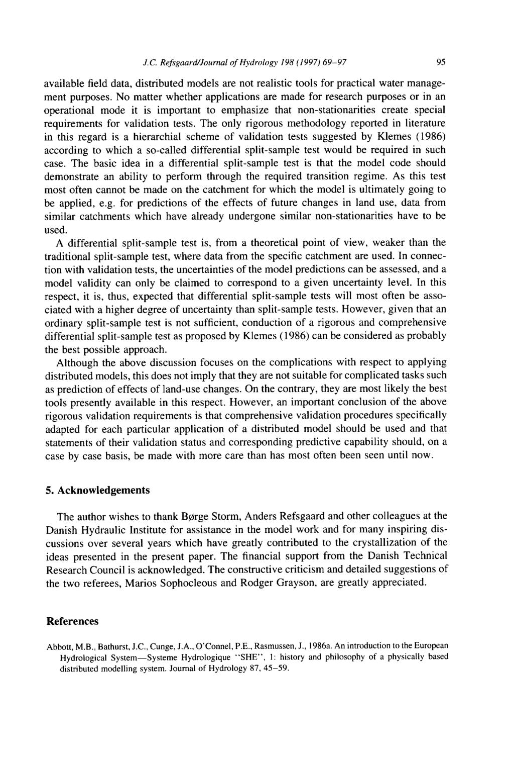
60 REFSGAARD AND KNUDSEN: INTERCOMPARISON OF HYDROLOGICAL MODELS 2191 question of whether the simpler or the more complex variants within this group of models are better, they concluded that significantly different models produced basically equivalent results, with calibration times being generally proportional to the complexity of their structure. On the other hand, they concluded that the model structure should not be made too simple, because it will then cause a loss of the link with the physics of the problem and of the possibility of taking advantage of prior knowledge of the geomorphological nature of the catchment. Other researchers have conducted similar intercomparison studies involving empirical black box models and lumped conceptual models [Naef, 1981; Wilcox et al., 1990] with similar conclusions. Only a few studies have included comparisons of distributed physically based models with simpler models. Loague and Freeze [1985] in a classical study compared two empirical black box modeling systems (a regression model and a unit hydrograph model) and a quasi physically based system on three small experimental catchments ranging from 10 ha to 7.2 km 2. The models were used on an event basis to simulate runoff peaks. The two empirical models were calibrated against runoff data and subsequently validated on independent data in an SS approach. The parameter values for the quasi physically based model were assessed directly from field data and not subject to any calibration before being validated against the same data as the two other models. Loague and Freeze [1985] found that all models performed poorly. For one catchment the quasi physically based model was subsequently applied with and without calibration of one key model parameter. Such calibration had little impact on the model performance during the validation period. In a study in the semiarid 150 km 2 Walnut Gulch experimental watershed Michaud and Sorooshian [1994] compared a lumped conceptual model (SCS), a distributed conceptual model (SCS with eight subcatchments, one per raingauge) and a distributed physically based model (KINEROS) for simulation of storm events. They found that with calibration, the accuracies of the two distributed models were similar. Without calibration the distributed physically based model performed better than the distributed conceptual model, and in both cases the lumped conceptual model performed poorly. Thus, as far as the test experience for distributed physically based models is concerned, both Loague and Freeze [1985] and Michaud and Sorooshian [1994] have performed tests on relatively small experimental catchments with very good data coverage. Both studies have used the models on ungauged conditions (without calibration) but in all cases under stationary climate conditions. The present paper presents results from larger catchments in Zimbabwe with ordinary data coverage and performs a sequence of rigorous tests of increasing complexity according to the hierarchial scheme outlined by Klemes [1986], involving intercomparisons between lumped conceptual and distributed physically based models. Hydrological Modeling Systems The following three modeling systems (codes) are used in the present study: a lumped conceptual rainfall-runoff modeling system (NAM), a semidistributed hydrological modeling system (WATBAL), and a distributed physically based hydrological modeling system (MIKE SHE). The NAM and MIKE SHE can be characterized as very typical of their respective classes, while the WATBAL falls in between these two standard classes. All three modeling systems are being used on a routine basis at the Danish Hydraulic Institute (DHI) in connection with consultancy and research projects. NAM NAM is a traditional hydrological modeling system of the lumped conceptual type operating by continuously accounting for the moisture contents in four mutually interrelated storages. The NAM was originally developed at the Technical University of Denmark [Nielsen and Hansen, 1973] and has been modified and extensively applied by DHI in a large number of engineering projects covering all climatic regimes of the world. Furthermore, the NAM has been transferred to more than 100 other organizations worldwide as part of DHI s MIKE 11 generalized river modeling package. The structure of NAM is illustrated in Figure 1. The NAM has in its present version a total of 17 parameters; however, in most cases only about 10 of these are adjusted during calibration. WATBAL WATBAL was developed in the early 1980s by DHI in an attempt to enable full utilization of readily available, distributed data on land surface properties (topography, vegetation, and soil) in a physically based model, and yet it is simple enough to allow large-scale applications within reasonable computational requirements. Here the WATBAL is briefly introduced; more detailed information has been given by Knudsen et al. [1986]. WATBAL has been designed to account for the spatial and temporal variations of soil moisture. On the basis of distributed information on meteorological conditions, topography, vegetation, and soil types, the catchment area is divided into a number of hydrological response units, as illustrated in Figure 2, with each unit being characterized by a different composition of the above features. These units are used to provide the spatial representation of soil moisture, while temporal variations within each unit are accounted for by means of empirical relations for the processes affecting soil moisture, using physical parameters particular to each unit. For the representation of subsurface flows a simple lumped, conceptual approach is applied, using a cascade of linear reservoirs to account for the interflow and baseflow components (Figure 3). In summary, WATBAL provides a distributed physically based description of the surface processes affecting soil moisture (interception, infiltration, evapotranspiration, and percolation), while a lumped conceptual approach is used to represent subsurface flows. WATBAL has previously been used successfully for prediction of runoff from ungauged catchments [Nielsen and Bari, 1988]. MIKE SHE MIKE SHE is a further development of the European Hydrological System SHE [Abbott et al., 1986a, b]. It is a deterministic, fully distributed and physically based modeling system for describing the major flow processes of the entire land phase of the hydrological cycle. MIKE SHE solves the partial differential equations for the processes of overland and channel flow and unsaturated and saturated subsurface flow. The system is completed by a description of the processes of snow melt, interception, and evapotranspiration. The flow equations are solved numerically using finite difference methods. In the horizontal plane the catchment is discretized in a
61 2192 REFSGAARD AND KNUDSEN: INTERCOMPARISON OF HYDROLOGICAL MODELS Figure 1. Structure of the NAM rainfall runoff modeling system [DHI, 1994]. network of grid squares. The river system is assumed to run along the boundaries of these. Within each square the soil profile is represented by a number of computational nodes in the vertical direction, which above the groundwater table may become partly saturated. Lateral subsurface flow is only considered in the saturated part of the profile. Figure 4 illustrates the structure of the MIKE SHE. A description of the methodology and some experiences of model application to ordi- Figure 2. WATBAL representation of catchment characteristics and definition of hydrological response units [Knudsen et al., 1986].
62 REFSGAARD AND KNUDSEN: INTERCOMPARISON OF HYDROLOGICAL MODELS 2193 Figure 3. Principal structure of WATBAL [Knudsen et al., 1986]. nary catchments have been given by Refsgaard et al. [1992] and Jain et al. [1992]. A more detailed description has been given by Refsgaard and Storm [1995]. MIKE SHE is usually categorized as a physically based system. The characterization is, strictly speaking, correct only if it is applied on an appropriate scale. A number of scale problems arise when the MIKE SHE is used on a regional scale [Refsgaard and Storm, 1995]. In addition, if there is a considerable Figure 4. Schematic presentation of the MIKE SHE [DHI, 1993b].
63 2194 REFSGAARD AND KNUDSEN: INTERCOMPARISON OF HYDROLOGICAL MODELS Figure 5. Location of the three catchments in Zimbabwe. uncertainty attached to the basic information, and if the spatial and temporal variables (such as groundwater table elevations) cannot be validated against observations, a MIKE SHE model of that particular site cannot be considered fully physically based but will degenerate towards a detailed conceptual model. In this case the calibration procedure is usually to adjust the parameters with the largest uncertainties attached, within a reasonable range. Case Study: Methodology Selected Catchments in Zimbabwe The three catchments in Zimbabwe that were selected for the model tests are Ngezi-South (1090 km 2 ), Lundi (254 km 2 ), and Ngezi-North (1040 km 2 ). The locations of the catchments are shown in Figure 5. A brief data collection/field reconnaissance to Zimbabwe was arranged to obtain relevant information. Daily series of rainfall and monthly series of pan evaporation were obtained from the Department of Meteorological Services. Records of mean daily discharges as well as information on water rights were obtained from the Hydrological Branch, Ministry of Energy Water Resources and Development. Detailed information on land use was obtained through subcontracting R. Whitlow, University of Zimbabwe, to prepare land-use maps based upon 1:25,000 aerial photographs. Furthermore, 1:50,000 topographical maps were collected and digitized. Information on vegetation characteristics was obtained from Timberlake [1989] as well as from J. Timberlake and N. Nobanda, National Herbarium (personal communication, 1989); B. Campell, Department of Biological Sciences (personal communication, 1989); and G. MacLaureen, Department of Crop Science, University of Zimbabwe (personal communication, 1989). Information on soil characteristics and hydrogeology was obtained from Anderson [1989]. Finally, valuable information of various kinds was provided by R. Whitlow, Department of Geography, University of Zimbabwe (personal communication, 1989); H. Elwell, Agritex (personal communication, 1989); J. Anderson, Chemistry and Soil Research Institute, Ministry of Agriculture (personal communication, 1989); and others. A more detailed description is given in DHI [1993a]. The annual catchment rainfall and runoff for the periods selected for modeling are shown in Table 1, while some of the key features for the three catchments are presented in Table 2. It is noticed from the rainfall and runoff figures in Table 1 that there are very large interannual variations. From Table 2 it appears that there are significant differences in the vegetation and soil characteristics from catchment to catchment. Model Testing Scheme The model testing scheme is illustrated in Figure 6. The testing of the involved models has been undertaken in parallel and in the following sequence. 1. The SS test was based on data from Ngezi-South comprising an initial calibration of the models and a subsequent validation using data for an independent period. 2. The PB test involved transfer of models to the Lundi catchment and adjustment of parameters to reflect the prevailing catchment characteristics and validation without any calibration. 3. The modified proxy-basin (M-PB) test was as above, but
64 REFSGAARD AND KNUDSEN: INTERCOMPARISON OF HYDROLOGICAL MODELS 2195 Table 1. Annual Rainfall and Runoff Values for the Three Zimbabwean Test Catchments Hydrological Year Rainfall, mm/yr Runoff, mm/yr Ngezi-South 1971/ / / / / / / / Lundi 1971/ / / / / / / / Ngezi-North 1977/ / / / / was adjusted by allowing model calibration based on 1 year of runoff data. 4. For the DSS test, model calibration was based on data from an initial calibration period, and validation was based on data from a subsequent period. The differential nature of this test is justified by the fact that the later independent period includes three successive years (1981/ /1984) with a markedly lower rainfall than would be otherwise and hence represents a nonstationary climate scenario. 5. The PB-DSS test involved transferring the models to the Ngezi-North catchment, adjusting the parameters to represent the catchment characteristics, and validating them by runoff simulation over a nonstationary climate period. 6. The modified proxy-basin differential split-sample (M- PB-DSS) test was as above, though it allowed models to be calibrated using a short-term (1 year) record. Evaluation Criteria For measuring the performance of the models for each test, a standard set of criteria has been defined. The criteria have been designed with the sole purpose of measuring how closely the simulated series of daily flows agree with the measured series. Owing to the generalized nature of the defined model validations, it has been necessary to introduce several criteria for measuring the performance with regard to water balance, low flows, and peak flows. The standard set of performance criteria comprises a combination of the following four graphical plots and three numerical measures: (1) joint plots of the simulated and observed hydrographs; (2) scatter diagram of monthly runoffs; (3) flow duration curves; (4) scatter diagram of annual maximum discharges; (5) overall water balance; (6) the Nash-Sutcliffe coefficient (R2); and (7) an index (EI) measuring the agreement between the simulated and observed flow duration curves. The coefficient R2, introduced by Nash and Sutcliffe [1970], is computed on the basis of the sequence of observed and simulated monthly flows over the whole testing period (perfect agreement for R2 is 1): M R2 1 m 1 2 M Q o m Q s m Q o m Q o 2 m 1 where M total number of months; s Q m simulated monthly flows; o Q m observed monthly flows; Q o average observed monthly flows over whole period. The flow duration curve error index, EI, provides a numerical measure of the difference between the flow duration curves of simulated and observed daily flows (perfect agreement for EI is 1): EI 1 f o q f s q dq f o q dq where f o (q) is the flow duration curve based on observed daily flows, and f s (q) is the flow duration curve based on simulated daily flows. Table 2. Land-Use Vegetation and Soil Characteristics Estimated From Available Information and a Brief Field Visit Catchment Ngezi-South Lundi Ngezi-North Land use/vegetation (area %) Dense/closed woody vegetation Open woody vegetation Sparse woody vegetation Grassland Cropland Abandoned cropland Rock outcrops Soil depth range, m Saturated hydraulic conductivity in root zone range: average: 80 range: 1 70 average: 60 range: average: 50 soil, mm/hr Available water content in root zone soil, vol % range: range: range: 9 29 average: 12 average: 11 average: 17
65 2196 REFSGAARD AND KNUDSEN: INTERCOMPARISON OF HYDROLOGICAL MODELS Figure 6. Model validation test schemes. Model Construction, Calibration, and Application All models have had access to the same hydrometeorological data and catchment information at any time. Due to the nature of the different models, however, the WATBAL and SHE have been able to make more direct use of the available information than the NAM. In this respect, the NAM has disregarded the spatial variation of rainfall and used the catchment average series as input, and for the simulation of ungauged catchments, a subjective evaluation of catchment characteristics has been undertaken for estimation of the appropriate model parameters. On the other hand, the WATBAL and SHE have attempted to account for the spatial variability of rainfalls as well as information on typical storm durations to convert daily rainfall series to realistic hourly rainfalls. Furthermore, these models have directly used the available information on the spatial variation of topography and soil and vegetation types and their characteristics for model setup and estimation of appropriate model parameters. As an illustration of the differences in model complexity and the different abilities of the three modeling systems to utilize the available distributed catchment data, some key facts for the three model applications to the 1090 km 2 Ngezi-South catchment are given in the following three paragraphs. The NAM model considered the entire catchment as one unit, utilized only catchment areal rainfall, and initially disregarded information on soil, vegetation, and geology. Such information was subsequently used on a subjective basis for assessing likely parameter values in the PB tests on the other two catchments. During the model calibrations (when allowed) the values of the 10 parameters were assessed. The WATBAL model was established on the basis of six meteorological zones, eight soil types, and 11 vegetation types. The spatial occurrences of these three features resulted in 129 hydrological response units. During the model calibrations (when allowed) parameter values reflecting root depths, soil water retention capacity, soil hydraulic conductivities, and time constants in subsurface flow routing were adjusted. The MIKE SHE also distributed the rainfall information to different inputs in six meteorological zones. Information on topography, soil, vegetation, and geology were distributed to a 1-km grid. Thus MIKE SHE carried out calculations at 1090 horizontal grid points. During the model calibrations (when allowed) parameter values reflecting soil depth and maximum root depths, as well as an empirical drainage time constant, were adjusted. In order to minimize the calibration work the parameter values were not varied within all 1090 grid points, but kept identical within each of the 13 land-use classes. In general, the parameters for which field data were available, such as soil water retention curves and leaf area index, were not modified during the calibration process. The present study has aimed at testing various types of general modeling systems. However, it should be emphasized that validation results are not solely dependent on the modeling system but, indeed, also depend on the hydrologist operating the model, including his or her personal interpretation of available information and subjective assessments. In the present study this element of uncertainty has been minimized to the extent possible by assigning three experienced hydrologists with comprehensive experience in the application of each of the three modeling systems and by providing each of them with the same catchment data. The calibration procedure adopted was that of trial and error, implying that the hydrologists made subjective adjustments of parameter values in between the calibration runs. The numerical and graphical performance criteria described above were used as important guidance for the hydrologists when deciding upon the set of parameter values which they assessed to be the optimal ones. As these decisions inevitably depend on the personal experiences and judgments of the hydrologists, it may be argued that this procedure adds an undesirable degree of subjectivity to the results. However, given the large number of performance criteria and the large number of adjustable parameters, especially in the WATBAL and MIKE SHE models, suitable and well-proven automatic parameter optimization techniques did not exist. Instead, by applying the standard calibration procedure by which the three hydrologists had comprehensive experience, the results may be seen as typical results from three different modeling systems, when using standard engineering procedures for data collection, model construction, and calibration. Results of Model Validation Test Scheme The results of the six tests outlined in Figure 6 are summarized in Figure 7, which shows the overall water balances and
66 REFSGAARD AND KNUDSEN: INTERCOMPARISON OF HYDROLOGICAL MODELS 2197 Figure 7. Summary of key validation results for all tests. the R2 and EI numerical criteria. Simulated and observed hydrographs are shown in Figure 8 for two of the tests from the Lundi and Ngezi-North catchments. Annual water balances are shown for all the tests in Figures Assessments of uncertainties in the PB predictions are shown in Figures 16 and 17. Note that the different performance criteria presented in the figures focus on different aspects, such as overall annual water balances (Figures 9 17), monthly flows (R2 in Figure 7), flow pattern on a daily basis (EI in Figure 7) and hydrograph shapes (Figure 8). The results are discussed test by test in the following sections. SS Test This test is based on data from Ngezi-South and comprises an initial calibration of the models and a subsequent validation using data for an independent period. As indicated in Figures 7, 9, and 10 the performances of the three models are very similar. All models are able to provide a close fit to the recorded flows for the calibration period, while for the independent validation period the performance is somewhat reduced, as expected. The reduction is, however, limited, and all models are able to maintain a very good representation of the overall water balance and the interannual and seasonal variations, as well as the general flow pattern. PB Test This test comprises a transfer of models to the Lundi catchment, adjustment of parameters to reflect the prevailing catchment characteristics, and validation without any calibration. The PB test was arranged to test the capability of the different models to represent runoff from an ungauged catchment area, and hence no calibration was allowed prior to the simulation. All models have used the experience from the Ngezi-South calibrations in combination with the available information on the particular catchment characteristics for Lundi. While the NAM model has used this information in a purely subjective manner to revise model parameters, both the WATBAL and MIKE SHE models have directly used this information for the model setup. The estimates prepared by the latter two models have, however, also been influenced by the individual modelers subjective interpretation of the available information on soil and vegetation characteristics. In order to assess the effects of the uncertainty in parameter estimation as perceived by the individual modelers, three alternative runoff simulations were prepared, reflecting expected low, central, and high (runoff) estimates, respectively. The results of the central estimates are included in Figures 7, 8a, and 11, while annual runoff figures for the assessed uncertainty intervals are shown in Figure 16. In general, all models provide an excellent representation of the general flow pattern and the overall water balance, while maintaining the significant interannual variability to a satisfactory degree. The predicted hydrographs for the rainy season of 1973/1974, shown in Figure 8a, confirm that the overall hydrograph pattern is predicted quite well by all three models. The overall performance of the central estimates by the NAM and MIKE SHE models is somewhat reduced compared to validation runs for the Ngezi-South catchment as expected when no calibration is possible. The estimates would, however, still be very valuable for all practical purposes. For the WATBAL model, the central estimate is even better than obtained for the validation period for Ngezi-South, providing for a very accurate representation of observed runoff record. From Figure 16 it appears that the assessed uncertainty interval for the NAM predictions of annual runoff is about twice as wide as for the WATBAL and MIKE SHE predictions. M-PB Test This test is based on the same data from Lundi as the above PB test. The M-PB test was undertaken to evaluate whether better model performance could be obtained should shortterm measurements be available for calibration. Hence, before the results of the previous test were revealed, 1 year (1975/ 1976) of runoff record was released for calibration, and the PB test repeated. The main results of this test are summarized in Figure 7, and annual water balances are shown in Figure 12. For the NAM model the short-term calibration leads to an improved performance, decreasing the deviation of the overall water balance to some 15%. At the same time, the statistics of R2 and EI confirm the good representation of monthly flows and the overall flow pattern in general. For the WATBAL model the short-term calibration introduces only a slight improvement in the overall performance. The reason for this is thought to be due to the originally very good performance, which in any case would be difficult to improve. The main benefit of the short runoff record is in this case primarily to confirm the validity of the central estimate
67 2198 REFSGAARD AND KNUDSEN: INTERCOMPARISON OF HYDROLOGICAL MODELS Figure 8. (a) Lundi (central estimates) proxy-basin (PB) test hydrographs from 1973/1974. (b) Ngezi-North (central estimates) PB differential split-sample (SS) test hydrographs for 1977/1978. and hence to reduce the uncertainty related to the final runoff estimate. In this sense the calibration has proven quite valuable and would indeed be so in any practical case. For the MIKE SHE model the calibration has not introduced any improvement in the overall performance. As compared to the best of the original estimates (i.e., the low case) the calibration has in fact caused a deterioration of the performance. This rather unfortunate incident may occur for all Figure 9. Annual water balances for the calibration part of the SS test on Ngezi-South catchment. Figure 10. Annual water balances for the validation part of the SS test on Ngezi-South catchment.
68 REFSGAARD AND KNUDSEN: INTERCOMPARISON OF HYDROLOGICAL MODELS 2199 Figure 11. catchment. Annual water balances for PB test on Lundi Figure 13. Annual water balances for differential split sample (DSS) test on Lundi catchment. types of models when calibration data are not fully consistent, but it appears that the SHE type of model requires a greater reliability of input data than other, more simple types of models to avoid the pitfall of miscalibration. DSS Test This test consists of model calibrations based on data from Lundi for 4 wet years (1971/ /1976 with mean annual runoff of 171 mm) and validation on data from 3 very dry years (1981/ /1984 with mean annual runoff of 8 mm). The purpose of this test is to assess the capability of the models to do simulations under nonstationary climate conditions. A summary of the main results of the differential SS tests is given in Figure 7, and the annual water balances are shown in Figure 13. As is evident from the results, both NAM and MIKE SHE predict the water balance well. The WATBAL model, however, grossly overestimates the peaks in the relative sense, causing the simulated average runoff to be about twice that measured (15 mm compared to 8 mm). The related statistics are poorer than those in the other testing schemes, but it should be noted that even small deviations cause poor statistics when mean flows are as low as those in this case. PB-DSS Test This test is based on data from the third catchment, Ngezi- North. Without allowing for any prior calibration, all modelers were requested to prepare low, central, and high estimates of the expected series of flows for the 1977/ /1984 period. This period contained a sequence of mainly wet years (1977/ /1981) followed by 3 consecutive dry years, with rainfalls being less than half of that experienced in the former period. At the stage when the measured flow record was revealed, it was unfortunately discovered that the record for the 1979/ /1981 years was erroneous and hence had to be disregarded when computing the test statistics. The results of this test are summarized in Figure 7, while the annual water Figure 12. Annual water balances for modified proxy-basin (M-PB) test on Lundi catchment. Figure 14. Annual water balances for proxy-basin differential split-sample (PB-DSS) test on Ngezi-North catchment.
69 2200 REFSGAARD AND KNUDSEN: INTERCOMPARISON OF HYDROLOGICAL MODELS Figure 17. Assessments of uncertainty interval for prediction of annual water balances in the PB-DSS test on Ngezi-North catchment. Figure 15. Annual water balances for modified proxy-basin differential split-sample (M-PB-DSS) test on Ngezi-North catchment. balances are shown in Figure 14. The assessed uncertainty intervals of the model predicted annual runoff are shown in Figure 17. From Figure 17 it appears that all models have managed to provide for a nonbiased range of estimates of the overall water balance, which for some models is quite narrow: NAM, 50%; WATBAL, 30%; and MIKE SHE, 10%. In terms of the overall water balance, the central estimates of the models agree within 25% (NAM), 5% (WATBAL), and 2% (MIKE SHE). The agreement between the recorded and simulated monthly flows and the flow duration curves, however, is less accurate for NAM and MIKE SHE than for the WATBAL model, which provides for an excellent fit in terms of these measures. The reason for the somewhat lower R2 and EI figures for the NAM model is related to its generally less accurate prediction of flows, while for the MIKE SHE model this is directly linked to the erroneous assessment of a key drainage parameter, causing the model to produce much more base flow than actually exist. Hydrographs showing measured discharge and predictions by the three models for the rainy season of 1977/1978 are presented in Figure 8b. These graphs confirm the conclusions derived from the numerical criteria, R2, and EI, namely, that Figure 16. Assessments of uncertainty interval for prediction of annual water balances in the PB test on Lundi catchment. the WATBAL reproduces the observed hydrograph very well, while the daily hydrograph for MIKE SHE reveals major errors in overall flow pattern. Note that the model which produces the best overall water balance (MIKE SHE) has at the same time the poorest fit when compared on daily values. M-PB-DSS Test This test is based on the same data from Ngezi-North as the previous PB-DSS test. Following the calibration of all models based on only 1 year of data (1977/1978), before the results for other years were revealed the above test was repeated. The main results of the modified test are shown in Figures 7 and 15. These results clearly demonstrate that access to only 1 year of runoff data has enabled all models to provide an excellent representation of the runoff within the entire testing period. The overall water balance agrees within 7% for all models and despite the fact that the calibration was based on a wet year, annual flows for the dry period come within the right order of magnitude, although the relative deviation in some cases is quite significant. The high R2 and EI scores achieved by all models confirm that the representation of the monthly flow sequence and the overall flow pattern has become very good after the calibration. Discussion and Conclusions The three generalized modeling systems, NAM, WATBAL, and MIKE SHE, have been subject to a rigorous testing scheme on data from three Zimbabwean catchments. NAM is a typical representative for the lumped conceptual class of models, while MIKE SHE similarly belongs to the distributed physically based class. WATBAL falls between the two classes. However, for the specific applications in Zimbabwe, where surface water hydrological aspects have been dominated, it can be argued that WATBAL can be considered as another representative of the distributed physically based class. Although establishing an objective framework for the model tests and intercomparisons has been attempted, it should be recognized that the results of a certain validation will be influenced by the specific test conditions, including the particular climate, catchment characteristics, data availability, and quality as well as subjective assessments made by the user (e.g., interpretation of available information for determining model parameters). Hence the obtained results are not only a function
70 REFSGAARD AND KNUDSEN: INTERCOMPARISON OF HYDROLOGICAL MODELS 2201 of the modeling system itself, but also of the user and numerous other factors. To arrive at a firm conclusion many validations would usually be required, and the limited number of tests undertaken therefore suggests that individual results may only be cautiously concluded. With this caution regarding generality in mind, a number of specific conclusions may be derived from the case study. First, in view of the difficult tasks given to the models involving simulation for ungauged catchments and nonstationary time periods, the overall performance of the models is considered quite impressive. The overall water balance agrees within 25% in all cases but one, and good results are achieved without balancing out excessive positive and negative deviations within individual years. In most cases the models score an R2 value at about 0.8 or greater and an EI index generally above 0.7. Secondly, the following is noted with regard to the specific types of validations tests: 1. For the SS test the NAM, WATBAL, and MIKE SHE systems generally exhibit similar performance. All models are able to provide a close fit to the recorded flows for the calibration period, without severely reducing the performance during the independent validation period. Hence this test suggests that if an adequate runoff period for a few (3 5) years exists, any of the modeling systems could be used as a reliable tool for filling in gaps in such records or used to extend runoff series based on long-term rainfall series. Considering the data requirements and efforts involved in the setup of the different models, however, a simple model of the NAM type should generally be selected for such tasks. 2. For the PB tests, designed for validating the capability of the models to represent flow series of ungauged catchments, it had been expected that the physically based models would produce better results than the simple type of models. The results, however, do not provide unambiguous support for this hypothesis. All three modeling systems generated good results, with the WATBAL providing slightly more accurate results than the others. Hence for the Zimbabwean conditions the additional capabilities of the MIKE SHE, as compared to the WATBAL, namely, the distributed physically based features relating to subsurface flow, proved to be of little value in simulating the water balance. For the PB tests it is noticed that the uncertainty range represented by the low and high estimates is significantly larger for the NAM than for the WAT- BAL and MIKE SHE cases. This probably reflects the fact that parameter estimation for ungauged catchments is generally more uncertain for the NAM, whose parameters are semiempirical coefficients without direct links to catchment characteristics. 3. A general experience of the M-PB tests is that allowing for model calibration based on only 1 year of runoff data improves the overall performance of all models. The improvement appears to be particularly significant for the NAM model, which also showed the largest uncertainties in the cases where no calibration was possible. 4. For the DSS tests all models have been able to simulate flows of the right order of magnitude and correct pattern. Hence all models have proven their ability to simulate the runoff pattern in periods with much reduced rainfall and runoff as compared to the calibration period. On the basis of these results there appears no immediate justification for using an advanced type of model to represent flows following a significant change of rainfall, providing a number of years are available for calibration purposes. It is tempting to extend this finding to suggest that the simple type of model could be used to assess the impact of climate change on water resources. It should be recognized, however, that above results cannot fully justify such a hypothesis, since a long-term climate change would probably bring about changes in vegetation and their evaporation. This type of nonstationarity has not been adequately tested. As far as the SS tests are concerned the above conclusion is in full agreement with results of other studies [e.g., Michaud and Sorooshian, 1994]. With regard to the PB tests the present conclusion in favor of the distributed physically based modeling systems is in agreement with, albeit more vague than, that of Michaud and Sorooshian [1994]. In summary, the present study, as well as similar studies reported in literature, suggests the following conclusions with regard to rainfall runoff modeling. 1. Given a few (1 3) years of runoff measurements, a lumped model of the NAM type would be a suitable tool from the point of view of technical and economical feasibility. This applies for catchments with homogeneous climatic input as well as cases where significant variations in the exogenous input is encountered. 2. For ungauged catchments, however, where accurate simulations are critical for water resources decisions, a distributed model is expected to give better results than a lumped model if appropriate information on catchment characteristics can be obtained. Acknowledgments. The modeling work on the Zimbabwe catchments were carried out by our colleagues Børge Storm and Merete Styczen (MIKE SHE) and Roar Jensen (NAM), while the second author was responsible for the WATBAL work. During the data collection and field reconnaissance in Zimbabwe, kind help and assistance was provided by University of Zimbabwe; National Herbarium; and Department of Meteorological Services and Hydrological Branch, Ministry of Energy, Water Resources and Development. The study was carried out with financial support from the Danish Council of Technology, and the paper preparation was supported by the Danish Technical Research Council. References Abbott, M. B., J. C. Bathurst, J. A. Cunge, P. E. O Connel, and J. Rasmussen, An introduction to the European Hydrological System Systeme Hydrologique Europeen, SHE, 1, History and philosophy of a physically based distributed modelling system, J. Hydrol., 87, 45 59, 1986a. Abbott, M. B., J. C. Bathurst, J. A. Cunge, P. E. O Connell, and J. Rasmussen, An introduction to the European Hydrological System Système Hydrologique Européen SHE, 2, Structure of a physically based distributed modelling system, J. Hydrol., 87, 61 77, 1986b. Anderson, J., Communal land physical resource inventory, Mhondoro and Ngezi, Draft Rep. A 551, Chem. and Soil Res. Inst., Minist. of Agric., Harare, Zimbabwe, Beven, K. J., Changing ideas in hydrology The case of physically based models, J. Hydrol., 105, , Danish Hydraulic Institute (DHI), Validation of hydrological models, Phase II, Hørsholm, 1993a. Danish Hydraulic Institute (DHI), MIKE SHE WM, short description, 1993b. Danish Hydraulic Institute (DHI), MIKE11 short description, Flavelle, P., A quantitative measure of model validation and its potential use for regulatory purposes, Adv. Water Resour., 15, 5 13, Franchini, M., and M. Pacciani, Comparative analysis of several conceptual rainfall-runoff models, J. Hydrol., 122, , Grayson, R. B., I. D. Moore, and T. A. McHahon, Physically based
71 2202 REFSGAARD AND KNUDSEN: INTERCOMPARISON OF HYDROLOGICAL MODELS hydrologic modeling, 2, Is the concept realistic?, Water Resour. Res., 28(10), , Jain, S. K., B. Storm, J. C. Bathurst, J. C. Refsgaard, and R. D. Singh, Application of the SHE to catchments in India, 2, Field experiments and simulation studies with the SHE on the Kolar subbasin to the Narmada River, J. Hydrol., 140, 25 47, Klemes, V., Sensitivity of water resources systems to climate variations, WCP Rep. 98, World Meteorological Organisation, Geneva, Klemes, V., Operational testing of hydrological simulation models, Hydrol. Sci. J., 31(1), 13 24, Knudsen, J., A. Thomsen, and J. C. Refsgaard, WATBAL: A semidistributed, physically based hydrological modelling system, Nordic Hydrol., 17, , Loague, K. M., and R. A. Freeze, A comparison of rainfall-runoff modeling techniques on small upland catchments, Water Resour. Res., 21(2), , Michaud, J., and S. Sorooshian, Comparison of simple versus complex distributed runoff models on a midsized semiarid watershed, Water Resour. Res., 30(3), , Naef, F., Can we model the rainfall-runoff process today?, Hydrol. Sci. Bull., 26(3), , Nash, I. E., and I. V. Sutcliffe, River flow forecasting through conceptual models, I, J. Hydrol., 10, , Nielsen, S. A., and Bari, Simulation of runoff from ungauged catchments by a semi-distributed hydrological modelling system, Proceedings, 6th IAHR Congress, Int. Assoc. for Hydraul. Res., Delft, Netherlands, Nielsen, S. A., and E. Hansen, Numerical simulation of the rainfallrunoff process on a daily basis, Nordic Hydrol., 4, , Refsgaard, J. C., Model and data requirements for simulation of runoff and land surface processes, in Proceedings from NATO Advanced Research Workshop Global Environmental Change and Land Surface Processes in Hydrology: The Trials and Tribulations of Modelling and Measurering, Tucson, May 17 21, 1993, edited by S. Sorooshian and V. K. Gupta, Springer-Verlag, New York, Refsgaard, J. C., and B. Storm, MIKE SHE, in Computer Models of Watershed Hydrology, edited by V. J. Singh, pp , Water Resour. Publ., Littleton, Colo., Refsgaard, J. C., S. M. Seth, J. C. Bathurst, M. Erlich, B. Storm, G. H. Jørgensen, and S. Chandra, Application of the SHE to catchments in India, 1, General results, J. Hydrol., 140, 1 23, Schlesinger, S., R. E. Crosbie, R. E. Gagné, G. S. Innis, C. S. Lalwani, J. Loch, J. Sylvester, R. D. Wright, N. Kheir, and D. Bartos, Terminology for model credibility, Simulation, 32(3), , Smith, R. E., D. R. Goodrich, D. A. Woolhiser, and J. R. Simanton, Comment on Physically based modeling, 2, Is the concept realistic? by R. B. Grayson, I. D. More, and T. A. McHahon, Water Resour. Res., 30(3), , Timberlake, J., Brief description of the vegetation of Mondoro and Ngezi communal lands, Mashonaland West, Natl. Herbarium, Harare, Zimbabwe, Tsang, C.-F., The modelling process and model validation, Ground Water, 29(6), , U.S. Committee, Task Committee on Quantifying Land-Use Change Effects, Evaluation of hydrological models used to quantify major land-use change effects, J. Irrig. Drain. Eng., 111(1), 1 17, Wilcox, B. P., W. J. Rawls, D. L. Brakensiek, and J. R. Wright, Predicting runoff from rangeland catchments: A comparison of two models, Water Resour. Res., 26(10), , World Meteorological Organization, (WMO), Intercomparison of conceptual models used in operational hydrological forecasting, WMO Oper. Hydrol. Rep. 7, WMO 429, Geneva, World Meteorological Organization (WMO), Third planning meeting on World Climate Programme Water, WCP 114, WMO/TD 106, Geneva, World Meteorological Organization (WMO), Intercomparison of models for snowmelt runoff, WMO Oper. Hydrol. Rep. 23, WMO 646, Geneva, World Meteorological Organization (WMO), Simulated real-time intercomparison of hydrological models, WMO Oper. Hydrol. Rep. 38, WMO 779, Geneva, J. Knudsen and J. C. Refsgaard, Danish Hydraulic Institute, Agern Alle 5, DK-2970 Hørsholm, Denmark. (Received September 25, 1995; revised March 15, 1996; accepted March 20, 1996.)
72
73 [7] Refsgaard JC (1997) Parametrisation, calibration and validation of distributed hydrological models. Journal of Hydrology, 198, Reprinted from Journal of Hydrology with permission from Elsevier
74

75

76
77

78

79

80
81

82

83

84
85
86
87
88
89

90
91
92

93

94
95
96

97
98

99
100

101

102
103 [8] Refsgaard JC (1997) Validation and Intercomparison of Different Updating Procedures for Real-Time Forecasting. Nordic Hydrology, 28, Reprinted with permission from Nordic Hydrology
104


105
106

107
108
109
110


111

112

113
114
115 [9] Refsgaard JC, Sørensen HR, Mucha I, Rodak D, Hlavaty Z, Bansky L, Klucovska J, Topolska J, Takac J, Kosc V, Enggrob HG, Engesgaard P, Jensen JK, Fiselier J, Griffioen J, Hansen S (1998) An Integrated Model for the Danubian Lowland Methodology and Applications. Water Resources Management, 12, Reprinted from Water Resources Management with permission from Springer (

116 Water Resources Management 12: , Kluwer Academic Publishers. Printed in the Netherlands. 433 An Integrated Model for the Danubian Lowland Methodology and Applications J. C. REFSGAARD 1,H.R.SØRENSEN 1, I. MUCHA 2, D. RODAK 2, Z. HLAVATY 2, L. BANSKY 2, J. KLUCOVSKA 2, J. TOPOLSKA 4, J. TAKAC 3, V. KOSC 3, H. G. ENGGROB 1, P. ENGESGAARD 5, J. K. JENSEN 5, J. FISELIER 6, J. GRIFFIOEN 7 and S. HANSEN 8 1 Danish Hydraulic Institute, Denmark 2 Ground Water Consulting Ltd., Bratislava, Slovakia 3 Irrigation Research Institute (VUZH), Bratislava, Slovakia 4 Water Research Institute (VUVH), Bratislava, Slovakia 5 Water Quality Institute (VKI), Denmark 6 DHV Consultants BV, The Netherlands 7 Netherlands Institute of Applied Geosciences TNO, The Netherlands 8 Royal Veterinary and Agricultural University, Denmark (Received: 30 December 1997; in final form: 10 November 1998) Abstract. A unique integrated modelling system has been developed and applied for environmental assessment studies in connection with the Gabcikovo hydropower scheme along the Danube. The modelling system integrates model codes for describing the reservoir (2D flow, eutrophication, sediment transport), the river and river branches (1D flow including effects of hydraulic control structures, water quality, sediment transport), the ground water (3D flow, solute transport, geochemistry), agricultural aspects (crop yield, irrigation, nitrogen leaching) and flood plain conditions (dynamics of inundation pattern, ground water and soil moisture conditions, and water quality). The uniqueness of the established modelling system is the integration between the individual model codes, each of which provides complex descriptions of the various processes. The validation tests have generally been carried out for the individual models, whereas only a few tests on the integrated model were possible. Based on discussion and examples, it is concluded that the results from the integrated model can be assumed less uncertain than outputs from the individual model components. In an example, the impacts of the Gabcikovo scheme on the ecologically unique wetlands created by the river branch system downstream of the new reservoir have been simulated. In this case, the impacts of alternative water management scenarios on ecologically important factors such as flood frequency and duration, depth of flooding, depth to ground water table, capillary rise, flow velocities, sedimentation and water quality in the river system have been explicitly calculated. Key words: Danube, environmental impacts, floodplain, Gabcikovo, groundwater, hydropower, integrated modelling, river branch. 434 J. C. REFSGAARD ET AL. Figure 1. The Danubian Lowland with the new reservoir and the Gabcikovo scheme. 1. Introduction 1.1. THE DANUBIAN LOWLAND AND THE GABCIKOVO HYDROPOWER SCHEME The Danubian Lowland (Figure 1) in Slovakia and Hungary between Bratislava and Komárno is an inland delta (an alluvial fan) formed in the past by river sediments from the Danube. The entire area forms an alluvial aquifer, which receives around 30 m 3 s 1 infiltration water from the Danube throughout the year, in the upper parts of the area and returns it to the Danube and the drainage canals in the downstream part. The aquifer is an important water resource for municipal and agricultural water supply. Human influence has gradually changed the hydrological regime in the area. Construction of dams upstream of Bratislava together with straightening and embanking of the river for navigational and flood protection purposes as well as exploitation of river sediments have significantly deepened the river bed and lowered the water level in the river and surrounding ground water level. These changes have had a significant influence on the ground water regime as well as the sensitive riverine forests downstream of Bratislava. Despite this basically negative trend the floodplain area with its alluvial forests and associated ecosystems still represents a unique landscape of outstanding ecological importance. The Gabcikovo hydropower scheme was put into operation in A large number of hydraulic structures has been established as part of the hydropower scheme. The key structures are a system of weirs across the Danube at Cunovo 15 km downstream of Bratislava, a reservoir created by the damming at Cunovo, a 30 km long lined power and navigation canal, outside the floodplain area, parallel to the Danube River with intake to the hydropower plant, a hydropower plant and two
.")
117 AN INTEGRATED MODEL FOR THE DANUBIAN LOWLAND 435 ship-locks at Gabcikovo, and an intake structure at Dobrohost, 10 km downstream of Cunovo, diverting water from the new canal to the river branch system. The entire scheme has significantly affected the hydrological regime and the ecosystem of the region, see, e.g., Mucha et al. (1997). The scheme was originally planned as a joint effort between former Czecho-Slovakia and Hungary, and the major parts of the construction were carried out as such on the basis of a 1977 international treaty. However, since 1989 Gabcikovo has been a major matter of controversy between Slovakia and Hungary, who have referred some disputed questions to international expert groups (EC, 1992, 1993a, b) and others to the International Court of Justice in The Hague (ICJ, 1997). Comprehensive monitoring and assessments of environmental impacts have been made, see Mucha (1995) for an overview. Since 1995 a joint Slovak-Hungarian monitoring program has been carried out (JAR, 1995, 1996, 1997) NEED FOR INTEGRATED MODELLING The hydrological regime in the area is very dynamic with so many crucial links and feedback mechanisms between the various parts of the surface- and subsurface water regimes that integrated modelling is required to thoroughly assess environmental impacts of the hydropower scheme. This is illustrated by the following three examples: Ground water quality. Based on qualitative arguments it was hypothesised that the damming and creation of the reservoir might lead to changes in the oxidation-reduction state of the ground water. The reason for this is that the reservoir might increase infiltration from the Danube to the aquifer because of increased head gradients. On the other hand, fine sediment matter might accumulate on the reservoir bottom, thereby creating a reactive sediment layer. The river water infiltrating to the aquifer has to pass this layer, which might induce a change in the oxidation status of the infiltrating water. This could affect the quality of the ground water from being oxic or suboxic towards being anoxic, which is undesirable for Bratislava s water works, most of which are located near the reservoir. Thus, the oxidation-reduction state of the groundwater is intimately linked to a balance between the rates of infiltrating reducing water and the aquifer oxidizing capacity. The infiltrating water is linked to the hydraulic behaviour of the reservoir: how large is the infiltration area and at which rates does the infiltration take place at different locations. However, without an integrated model it is not possible to quantify whether and under which conditions these mechanisms play a significant role in practise, whether they are correct in principle but without practical importance, and what measures should be realised. Agricultural production. Changes in discharges in the Danube caused by diversion of some of the water through the power canal and creation of a reservoir 436 J. C. REFSGAARD ET AL. Figure 2. Important processes and their interactions with regard to floodplain hydrology. would lead to changes in the ground water levels. As the agricultural crops depend on capillary rise from the shallow ground water table and irrigation, the new hydrological situation created by the damming of the Danube might influence both the crop yield, the irrigation requirements and the nitrogen leaching. Traditional crop models describing the root zone are not sufficient in this case, because the lower boundary conditions (ground water levels) are changed in a way that can only be quantified if also the reservoir, the river and canal system and the aquifer are explicitly included in the modelling. Floodplain ecosystem. The flora and fauna, which in the floodplain area are dominated by the river side branches, depend on many factors such as flooding dynamics, flow velocities, depth of ground water table, soil moisture, water quality and sediments. Also in this case the important factors depend on the interaction between the groundwater and the surface water systems (illustrated in Figure 2), and even on water quality and sediments in the surface water system, so that quantitative impact assessments require an integrated modelling approach. 2. Integrated Modelling System 2.1. INDIVIDUAL MODEL COMPONENTS An integrated modelling system (Figure 3) has been established by combining the following existing and well proven model codes: MIKE SHE (Refsgaard and Storm, 1995) which, on a catchment scale, can simulate the major flow and transport processes in the hydrological cycle: 1-D flow and transport in the unsaturated zone

118 AN INTEGRATED MODEL FOR THE DANUBIAN LOWLAND 437 Figure 3. Structure of the integrated modelling system with indication of the interactions between the individual models. 3-D flow and transport in the ground water zone 2-D flow and transport on the ground surface 1-D flow and transport in the river. All of the above processes are fully coupled allowing for feedback s and interactions between components. In addition, MIKE SHE includes modules for multi-component geochemical and biodegradation reactions in the saturated zone (Engesgaard, 1996). MIKE 11 (Havnø et al., 1995), is a one-dimensional river modelling system. MIKE 11 is used for simulating hydraulics, sediment transport and morphology, and water quality. MIKE 11 is based on the complete dynamic wave formulation of the Saint Venant equations. The modules for sediment transport and morphology are able to deal with cohesive and noncohesive sediment transport, as well as the accompanying morphological changes of the river bed. The noncohesive model operates on a number of different grain sizes. MIKE 21 (DHI, 1995), which has the same basic characteristics as MIKE 11, extended to two horizontal dimensions, and is used for reservoir modelling. MIKE 11 and MIKE 21 include River/Reservoir Water Quality (WQ) and Eutrophication (EU) (Havnø et al., 1995; VKI, 1995) modules to describe oxygen, ammonium, nitrate and phosphorus concentrations and oxygen demands as well as eutrophication issues such as bio-mass production and degradation. DAISY (Hansen et al., 1991) is a one-dimensional root zone model for simulation of soil water dynamics, crop growth and nitrogen dynamics for various agricultural management practices and strategies. 438 J. C. REFSGAARD ET AL INTEGRATION OF MODEL COMPONENTS The integrated modelling system is formed by the exchange of data and feedbacks between the individual modelling systems. The structure of the integrated modelling system and the exchange of data between the various modelling systems are illustrated in general in Figure 3 and the steps in the integrated modelling is described further in Section 6.2 and illustrated in Figure 10 for the case of flood plain modelling. The interfaces between the various models indicated in Figure 3 are A) MIKE SHE forms the core of the integrated modelling system having interfaces to all the individual modelling systems. The coupling of MIKE SHE and MIKE 11 is a fully dynamic coupling where data is exchanged within each computational time step, see Section 2.3 below. B) Results of eutrophication simulations with MIKE 21 in the reservoir are used to estimate the concentration of various water quality parameters in the water that enters the Danube downstream of the reservoir. This information serves as boundary conditions for water quality simulations for the Danube using MIKE 11. C) Sediment transport simulations in the reservoir with MIKE 21 provide information on the amount of fine sediment on the bottom of the reservoir. The simulated grain size distribution and sediment layer thickness is used to calculate leakage coefficients, which are used in ground water modelling with MIKE SHE to calculate the exchange of water between the reservoir and the aquifer. D) The DAISY model simulates vegetation parameters which are used in MIKE SHE to simulate the actual evapotranspiration. Ground water levels simulated with MIKE SHE act as lower boundary conditions for DAISY unsaturated zone simulations. Consequently, this process is iterative and requires several model simulations. E) Results from water quality simulations with MIKE 11 and MIKE 21 provide estimates of the concentration of various components/parameters in the water that infiltrates to the aquifer from the Danube and the reservoir. This can be used in the ground water quality simulations (geochemistry) with MIKE SHE. A general discussion on the limitations in the above couplings is given in Section 7 below A COUPLING OF MIKE SHE AND MIKE 11 The focus in MIKE SHE lies on catchment processes with a comparatively less advanced description of river processes. In contrary, MIKE 11 has a more advanced description of river processes and a simpler catchment description than MIKE SHE. Hence, for cases where full emphasis is needed for both river and catchment processes a coupling of the two modelling systems is required.
.")
119 AN INTEGRATED MODEL FOR THE DANUBIAN LOWLAND 439 Figure 4. Principles of the coupling between the MIKE SHE catchment code and the MIKE 11 river code. A full coupling between MIKE SHE and MIKE 11 has been developed (Figure 4). In the combined modelling system, the simulation takes place simultaneously in MIKE 11 and MIKE SHE, and data transfer between the two models takes place through shared memory. MIKE 11 calculates water levels in rivers and floodplains. The calculated water levels are transferred to MIKE SHE, where flood depth and areal extent are mapped by comparing the calculated water levels with surface topographic information stored in MIKE SHE. Subsequently, MIKE SHE calculates water fluxes in the remaining part of the hydrological cycle. Exchange of water between MIKE 11 and MIKE SHE may occur due to evaporation from surface water, infiltration, overland flow or river-aquifer exchange. Finally, water fluxes calculated with MIKE SHE are exchanged with MIKE 11 through source/sink terms in the continuity part of the Saint Venant equations in MIKE 11. The MIKE SHE MIKE 11 coupling is crucial for a correct description of the dynamics of the river-aquifer interaction. Firstly, the river width is larger than one MIKE SHE grid, in which case the MIKE SHE river-aquifer description is no longer valid. Secondly, the river/reservoir system comprises a large number of hydraulic structures, the operation of which are accurately modelled in MIKE 11, but cannot be accounted for in MIKE SHE. Thirdly, the very complex river branch system with loops and flood cells needs a very efficient hydrodynamic formulation such as in MIKE J. C. REFSGAARD ET AL COMPARISON TO OTHER MODELLING SYSTEMS REPORTED IN LITERATURE Yan and Smith (1994) described the demand and outlined a concept for a full integrated ground water surface water modelling system including descriptions of hydraulic structures and agricultural irrigation as a decision support tool for water resources management in South Florida. Typical examples of integrated codes described in the literature are Menetti (1995) and Koncsos et al. (1995). In a review of recent advances in understanding the interaction of groundwater and surface water Winter (1995) mainly describes groundwater codes, such as MODFLOW, which have been expanded with some, but very limited, surface water simulation capabilities. The research activities are characterized as... although studies of these systems have increased in recent years, this effort is minimal compared to what is needed. Winter (1995) sees the prospects for the future as follows: Future studies of the interaction of groundwater and surface water would benefit from, and indeed should emphasise, interdisciplinary approaches. Physical hydrologists, geochemists, and biologists have a great deal to learn from each other, and contribute to each other, from joint studies of the interface between groundwater and surface water. Integrated three-dimensional descriptions of flow, transport and geochemical processes is still rarely seen for groundwater modelling of large basins. Thus, according to a recent review of basin-scale hydrogeological modelling (Person et al., 1996) most of the existing reactive transport model codes are based on one-dimensional descriptions. While many model codes contain a distributed physically-based representation of one of the three main components: ground water, unsaturated zone, and surface water systems, only few codes provide a fully integrated description of all these three main components. For example in an up-to-date book (Singh, 1995) presenting descriptions of 25 hydrological codes only three codes, SHE/SHESED (Bathurst et al., 1995), IHDM (Calver and Wood, 1995) and MIKE SHE (Refsgaard and Storm, 1995) provide such integrated descriptions. Among these three codes only MIKE SHE has capabilities for modelling advection-dispersion and water quality. None of the three codes contained options for computations of hydraulic structures in river systems, nor agricultural modelling such as crop yield and nitrogen leaching. The individual components of the integrated modelling system presented in this paper, we believe, represent state-of-the-art within their respective disciplines. The uniqueness is the full integration. 3. Methodology for Model Construction, Calibration, Validation and Application The terminology and methodology used in the following is based on the concepts outlined in Refsgaard (1997).
120 AN INTEGRATED MODEL FOR THE DANUBIAN LOWLAND MODEL CONSTRUCTION All of the applied models are based on distributed physically-based model codes. This implies that most of the required input data and model parameters can ideally be measured directly in nature MODEL CALIBRATION The calibration of a physically-based model implies that simulation runs are carried out and model results are compared with measured data. The adopted calibration procedure was based on trial and error implying that the model user in between calibration runs made subjective adjustments of parameter values within physically realistic limits. The most important guidance for the model user in this process was graphical display of model results against measured values. It may be argued that such manual procedure adds a degree of subjectivity to the results. However, given the very complex and integrated modelling focusing on a variety of output results and containing a large number of adjustable parameters, automatic parameter optimisation is not yet possible and trial and error still becomes the only feasible method in practise MODEL VALIDATION Good model results during a calibration process cannot automatically ensure that the model can perform equally well for other time periods as well, because the calibration process involves some manipulation of parameter values. Therefore, model validations based on independent data sets are required. To the extent possible, limited by data availability, the models have been validated by demonstrating the ability to reproduce measured data for a period outside the calibration period, using a so-called split-sample test (Klemes, 1986). For some of the models, the model was even calibrated on pre-dam conditions and validated on post-dam conditions, where the flow regime at some locations was significantly altered due to the construction of the reservoir and related hydraulic structures and canals MODEL APPLICATION The validated models have finally been used, as an integrated system, in a scenario approach to assess the environmental impacts of alternative water management options. The uncertainties of the model predictions have been assessed through sensitivity analyses. 442 J. C. REFSGAARD ET AL. 4. Selected Results from Model Construction, Calibration and Validation of Individual Components Comprehensive data collection and processing as well as model calibration and validation were carried out (DHI et al., 1995). In the following sections a few selected results are presented for the individual components. Further aspects of model validation focusing on integrated aspects are discussed in Section RIVER AND RESERVOIR FLOW MODELLING The following models have been constructed, calibrated and validated: one-dimensional MIKE 11 model for the Danube from Bratislava to Komarno, one-dimensional MIKE 11 model for the river branch system at the Slovak floodplain, and two-dimensional MIKE 21 model for the reservoir. The MIKE 11 models have been established in two versions reflecting post- and pre-dam conditions, respectively MIKE 11 River Model for the Danube The MIKE 11 model for the Danube is based on river cross-sections measured in 1989 and The applied boundary conditions were measured daily discharges at Bratislava (upstream) and a discharge rating curve at Komarno (downstream). The model was initially calibrated for two steady state situations reflecting a low flow situation (905 m 3 s 1 ) and a flow situation close to the long term average (2390 m 3 s 1 ), respectively. Subsequently, the model was calibrated in a nonsteady state against daily water level and discharge measurements from The model was finally validated by demonstrating the ability to reproduce measured daily water level data from Calibration and validation results are presented in Topolska and Klucovska (1995). For the post-dam model some river reaches were updated with cross-sections measured in In addition, the reservoir and related hydraulic structures and canals were included. As the conditions after damming of the Danube have changed significantly, re-calibration of the post-dam model was carried out for the period April 1993 July Subsequently, the model was validated against measured data from the period November 1992 March MIKE 11 Model for the River Branch System The Danubian floodplain is a forest area of major ecological interest characterised by a complex system of river branches. A layout of the river branch system is shown in Figure 5. The cross-sections in the river branch system were measured during the 1960 s and 1970 s. The pre-dam model was calibrated against water level and flow data from the 1965 flood. In the post-dam situation, the branch system is fed by an
121 AN INTEGRATED MODEL FOR THE DANUBIAN LOWLAND 443 Figure 5. Layout of the river branch system on the Slovakian side of the Danube. inlet structure with water from the power canal. The system consists of a number of compartments (cascades) separated by small dikes. On each of these dikes combined structures of culverts and spillways are located enabling some control of the water levels and flows in the system. Results of the model calibration against data measured during the summer 1994 are shown in Klucovska and Topolska (1995). Finally, the model was validated by demonstrating the ability to reproduce water levels measured during the summer of Some of these results are presented in Sørensen et al. (1996) MIKE 21 Reservoir Model A MIKE 21 hydrodynamic model for the reservoir was established based on a reservoir bathymetry measured in The spatial resolution of the finite difference model is m. The model was calibrated against flow velocities measured in the reservoir in the autumn of GROUND WATER FLOW MODELLING Ground water modelling has been carried out at three different spatial scales: A regional ground water model for pre-dam conditions (3000 km 2, 500 m horizontal grid, 5 vertical layers). A regional ground water model for post-dam conditions (3000 km 2, 500 m horizontal grid, 5 vertical layers). A local ground water model for an area surrounding the reservoir for both preand post-dam conditions (200 km 2, 250 m horizontal grid, 7 vertical layers). A local ground water model for the river branch system for both pre- and postdam conditions (50 km 2, 100 m horizontal grid, 2 vertical layers). A cross-sectional (vertical profile) model near Kalinkovo at the left side of the reservoir (2 km long, 10 m horizontal grid, 24 vertical layers). The regional and local ground water models all use the coupled version of the MIKE SHE and MIKE 11 and hence, include modelling of evapotranspiration and 444 J. C. REFSGAARD ET AL. snowmelt processes, river flow, unsaturated flow and ground water flow. The crosssectional model only includes ground water processes Model Construction Comprehensive input data were available and used in the construction of the models. In general, the regional and the local models are based on the same data with the main difference being that the local models provide finer resolutions and less averaging of measured input data. The two regional models, reflecting pre- and post-dam conditions, are basically the same. The only difference is that the postdam model includes the reservoir and related hydraulic structures and seepage canals. The models are based on information on location of river systems and crosssectional river geometry, surface topography, land use and cropping pattern, soil physical properties and hydrogeology. In addition, time series of daily precipitation, potential evapotranspiration and temperature as well as discharge inflow at Bratislava have been used. Comprehensive geological data exist from this area, see e.g., Mucha (1992) and Mucha (1993). The aquifer, ranging in thickness from about 10 m at Bratislava to about 450 m at Gabcikovo, consists of Danube river sediments (sand and gravel) of late Tertiary and mainly Quaternary age. The present model is based on the work of Mucha et al. (1992a, b) Model Calibration The ground water model was calibrated against selected measured time series of ground water levels. The following parameters were subject to calibration: specific yield in the upper aquifer layer, leakage coefficients for the river bed and hydraulic conductivities for the aquifer layers. The soil physical characteristics for the unsaturated zone have been adopted directly from the unsaturated zone/agricultural modelling. The river model that has been used in the ground water modelling is identical to the MIKE 11 river model of the Danube, which was successfully validated independently as a stand alone model (Subsection 4.1, above). When coupling MIKE SHE and MIKE 11 water is exchanged between the two models. The amount of water that recharges the aquifer in the upstream part and re-enters the river further downstream is in the order of m 3 s 1 depending on the Danube discharge and on the actual ground water level. The recharge is typically two orders of magnitude less than the Danube discharge, and hence, a re-calibration of the MIKE 11 river model is not required. As the major part of the ground water recharge originates from infiltration through the river bed, the leakage coefficient for the river bed becomes very important. Limited field information was available on this parameter, and hence, it was assumed spatially constant and through calibration assessed to be s 1 for the Danube and Vah rivers and s 1 for

122 AN INTEGRATED MODEL FOR THE DANUBIAN LOWLAND 445 the Little Danube. These values are in good agreement with previous modelling experiences (Mucha et al., 1992b). When keeping the specific yield and the leakage coefficients for the river bed fixed the main calibration parameters were the hydraulic conductivities of the saturated zone. About 300 time series of ground water level observations were available for the model area, typically in terms of yr of weekly observations. The calibration was carried out on the basis of about 80 of these series for the period In the parameter adjustments the overall spatial pattern described in the geological model were maintained. Some of the calibration results are illustrated in Figure 6 showing observed Danube discharge data together with simulated and measured ground water levels for three wells located at different distances from the Danube. Wells 694 and 740 are seen to react relatively quickly to fluctuations in river discharge as compared to well 7221, which is located further away from the river. This illustrates how the dynamics of the Danube propagates and is dampened in the aquifer Model Validation The calibrated ground water model was validated by demonstrating the ability to reproduce measured ground water tables after damming of the Danube. In this regard the only model modification is the inclusion of the reservoir and related structures and canals. Due to the nonstationarity of the hydrological regime such a validation test, which according to Klemes (1986) is denoted a differential splitsample test, is a demanding test. Figure 7 shows the simulated and observed ground water levels for the same three observation wells as shown for the calibration period in Figure 6. The effects of the damming of the Danube in October 1992, when the new reservoir was established, is clearly seen in terms of increased ground water levels and reduced ground water dynamics when comparing the two figures. These features are well captured by the model GROUND WATER QUALITY A geochemical field investigation was carried out in a cross-section north of the reservoir near Kalinkovo as a basis for identifying the key geochemical processes and estimating parameter values (see Mucha, 1995). Eleven multi-screen wells were installed close to the water supply wells at Kalinkovo forming a 7.5 km long cross-section parallel to the regional ground water flow direction. The multi-screen wells have been sampled frequently to investigate the ongoing bio-geochemical processes during infiltration of the Danube river water into the aquifer. A ground water quality model was established for the Kalinkovo cross-sectional profile based on all the measured field data. This model includes a comprehensive description of the bio-geochemical processes such as kinetically controlled denitrification and equilibrium controlled inorganic chemistry based on the well known PHREEQE code. More details are given in Griffioen et al. (1995) and 446 J. C. REFSGAARD ET AL. Figure 6. Danube discharge at Bratislava together with simulated and observed ground water levels for three wells before the damming of the Danube (calibration period).
123 AN INTEGRATED MODEL FOR THE DANUBIAN LOWLAND 447 Figure 7. Simulated and observed ground water levels for three wells after damming of the Danube (validation period). Engesgaard (1996). The transport part of the Kalinkovo cross-section has been calibrated against 18 O isotope data. The parameters describing reactive processes have been assessed and adjusted on the basis of the detailed field measurements in the Kalinkovo cross-sectional profile. It was shown that the geochemical model behaves qualitatively correct (Engesgaard, 1996) UNSATURATED ZONE AND AGRICULTURAL MODELLING Modelling of the pre-dam and post-dam conditions of agricultural potential and nitrate leaching risk was carried out using a representative selection of soil units, cropping pattern and meteorological data covering the area between Danube and Maly Danube (Figure 1). The DAISY model uses time-varying ground water levels (simulated with the regional MIKE SHE ground water model) as lower boundary condition, for the unsaturated flow simulations. Cropping pattern and fertiliser application is included in the model based on measurements and statistical data. The model was calibrated on the basis of data from field experiments carried out during the years at the experimental station in Most near Bratislava. During this process the crop parameters used in the model were adjusted to Slovak 448 J. C. REFSGAARD ET AL. conditions. After the initial model construction and calibration, the model performance was evaluated through preliminary simulations using data from a number of plots located on an experimental field site at Lehnice in the middle of the project area. On the basis of comparisons between measured and simulated values of nitrogen uptake, dry matter yield and nitrate concentrations in soil moisture, the model performance under Slovak conditions was considered satisfactory (DHI et al., 1995) RIVER AND RESERVOIR SEDIMENT TRANSPORT MODELLING Danube River Sediment Transport A one-dimensional morphological model was established for the Danube. The model operates with cross-sectional averaged parameters representing the river reach between every computational point (i.e. approximately 500 m), a special technique for comparing real and simulated state variables was required. Therefore, the changes in mean water level over a decade rather than changes in bed elevations were compared between observations and simulations. For this purpose the changes in the so-called Low Regulation and Navigable Water Level (LR- NWL) were used. LR-NWL is specified by the Danube Commission as the water level corresponding to Q94% which is approximately 980 m 3 s 1. By using such an approach, perturbations in bed levels from one cross-section to another did not destroy the picture of the overall trends in aggradation and degradation of the river bed. The results of the calibration ( ) and validation runs ( ) are described in Topolska and Klucovska (1995) Sediment Transport in the River Branch System A one-dimensional fine sediment model was constructed for the river branch system in order to have a tool for quantitative evaluation of the possible sedimentation in the river branch system for alternative water management options. The upstream boundary condition for the model was provided in terms of concentration of suspended sediments simulated by the reservoir model. As virtually no field data on sedimentation in the river branch system were available neither calibration nor validation was possible. Instead, experienced values of model parameters from other similar studies as reported in the literature were used Reservoir Sediment Model A two-dimensional fine graded sediment model was constructed for the reservoir. The suspended sediment input was imposed as a boundary condition in Bratislava with time series of sediment concentrations of six suspended sediment fractions with their own grain sizes and fall velocities. The fall velocity for each of the six fractions was assessed according to field measurements. No further model calibration was carried out. The only field data available for validation were a few bed
124 AN INTEGRATED MODEL FOR THE DANUBIAN LOWLAND 449 sediment samples from summer 1994 with data on sedimentation thickness and grain size analyses (Holobrada et al., 1994). A comparison of model results and field data indicated that a reservoir sedimentation of the right order of magnitude was simulated. The simulated reservoir sedimentation corresponded to 42% of the total suspended load at Bratislava SURFACE WATER QUALITY MODELLING Danube River Model A BOD-DO model (MIKE 11 WQ) has been used to describe the water quality in the main stream of the Danube between Bratislava and Komarno. This model describes oxygen concentration (DO) as a function of the decay of organic matter (BOD), transformation of nitrogen components, re-aeration, oxygen consumption by the bottom and oxygen production and respiration by living organisms. As the conditions from pre-dam to post-dam have changed significantly, separate calibrations and validations were carried out. The pre-dam model was calibrated against data from October 1991 and validated against data from April and August/September The post-dam model was calibrated against data from May 1993 and validated against data from June Model for the River Branch System The water quality in the river branches was simulated with a eutrophication model (MIKE 11 EU), in which the algae production is the driving force. The algae growth in this model is described as a function of incoming light, transparency of the water, temperature, sedimentation and growth rate of the algae and of the available inorganic nutrients. The calibration was carried out on the basis of few data available during the period June August Due to lack of further data no independent model validation was possible and hence, the uncertainties related to applying the model for making quantitative predictions of the effects of alternative water management schemes may be considerable Reservoir Model In the reservoir the driving force is also the algae growth and hence, a eutrophication model (MIKE 21 EU) was applied. The reservoir model was calibrated against measured data from August This field programme was substantial and resulted in much more data than available for the river branch system. Good correspondence between simulated and observed values were achieved during the calibration period. However, no further data have been available for independent validation tests. 450 J. C. REFSGAARD ET AL. 5. Validation of Integrated Model The model calibration and validation have basically been carried out for the individual models using separate domain data for river system, aquifer system, etc. Rigorous validation tests of the integrated model were generally not possible due to lack of specific and simultaneous data on the processes describing the various couplings. Furthermore, although reasonable good assessments of uncertainties of the individual model predictions could be made, it was not obvious how such uncertainty would propagate in the integrated model. It can be argued that uncertainties in output from one model would in principle influence the uncertainties in other components of the integrated modelling system, thus adding to the total uncertainty of the integrated model. Following this line of argument would lead to the conclusion that the uncertainty of predictions by the integrated model would be larger than the corresponding uncertainty of predictions made by traditional individual models. On the other hand it can also be argued that in the integrated modelling approach the uncertainties in the crucial boundary conditions are reduced, because assumptions needed for executing individual models are substituted by model simulations based on data from neighbouring domains, which, if properly calibrated and validated, better represent the boundary effects. This would lead to the conclusion that the uncertainties in predictions by the integrated model would be smaller than those of the individual models. In the present study, no theoretical analyses have been made of this problem. Instead, a few validation tests have been made for cases where the couplings could indirectly be checked by testing the performance of the integrated model against independent data. In the following, results from one of these validation tests for the integrated model are shown. The river-aquifer interaction changed significantly, when the reservoir was established. An important model parameter describing this interaction is the leakage coefficient, which was calibrated on the basis of ground water level data for the predam situation (Subsection 4.2). For the post-dam situation the MIKE 21 reservoir model calculates the thickness and grain sizes of the sedimentation at all points in the reservoir. By use of the Carman-Kozeny formula, the leakage factors are recalculated for the area which was now covered by the reservoir. The model results were then checked against ground water level observations from wells near the reservoir, and it was found, that a calibration factor of 10 had to be applied to the Carman-Kozeny formula. This can theoretically be justified by the fact that the sediments are stratified or layered due to variations in flow velocities during the sedimentation process. The same formula and the same calibration factor was also used for converting all texture data from aquifer sediment samples to hydraulic conductivity values in the model. Now, how can the validity of the integrated model be tested? The ground water level observations from a few wells have been used to assess the leakage calibration factor, so although the model output was subsequently checked against data from


125 AN INTEGRATED MODEL FOR THE DANUBIAN LOWLAND 451 Figure 8. Measured and simulated discharges in seepage canals. The data are from a particular day in May 1995 and in m 3 s 1. many more wells, it may be argued that this in itself is not sufficient for a true model validation. Consider instead a comparison of simulated and measured discharges in the so-called seepage canals, which are small canals constructed a few hundred meters away from the reservoir with the aim of intercepting part of the infiltration through the bottom of the reservoir. In Figure 8 it can be seen that the model simulations match the measured data remarkably well at different locations along the seepage canals. Thus, at the two stations most downstream on both seepage canals (stations 2809 and 3214) the agreements between model predictions and field data are within 5%. This is a powerful test, because the discharge data have not been used at all in the calibration process, and because it integrates the effects of reservoir sedimentation, calculation of leakage factors and geological parameters. 6. Model Application Case Study of River Branch System 6.1. HYDROLOGY OF RIVER BRANCH SYSTEM The hydrology of the river branch system is highly complex with many processes influencing the water characteristics of importance for flora and fauna (Figure 2). These processes are highly interrelated and dynamic with large variations in time and space. The complexity of the floodplain, with its river branch system, is indicated in Figures 5 and 9 for the 20 km reach downstream the reservoir on the Slovakian side, where alluvial forest occurs. Before the damming of the Danube 452 J. C. REFSGAARD ET AL. Figure 9. Plan and perspective view of the surface topography, of the river branches and the related flood plains as represented in a model network of 100 m grid squares. in 1992 the river branches were connected with the Danube during periods with discharge above average. However, some of the branches were only active during flood situations a few days per year. It was anticipated that after the damming, the water level in the Danube would decrease significantly. Therefore, in order to avoid that water drains from the river branches to the Danube, resulting in totally dry river branches, the water outflow from branches into the Danube have been blocked except for the downstream one at chainage 1820 rkm (Figure 5). Now, the river branch system receives water from an inlet structure in the hydropower canal at Dobrohost (Figure 5). This weir has a design capacity of 234 m 3 s 1. Together with the various hydraulic structures in the river branches, it controls the hydraulic, hydrological and ecological regime in the river branches and on the flood plains.
126 AN INTEGRATED MODEL FOR THE DANUBIAN LOWLAND 453 Figure 10. Steps in integrated model for floodplain hydrology MODELLING APPROACH Comprehensive field studies and modelling analyses are often carried out in connection with assessing environmental impacts of hydropower schemes. Recent examples from the Danube include the studies of the Austrian schemes Altenwörth (Nachtnebel, 1989) and Freudenau (Perspektiven, 1989). However, like in the Austrian cases, the modelling studies have most often been limited to independent modelling of river systems, groundwater systems or other subsystems, without providing an integrated approach as the one presented in this paper. The models in this study were applied in a scenario approach simulating the hydrological conditions resulting from alternative possible operations of the entire system of hydraulic structures (alternative water management regimes). Thus, one historical (pre-dam) regime and three hypothetical (post-dam) water regimes cor- 454 J. C. REFSGAARD ET AL. responding to alternative operation schemes for the structures of the Gabcikovo system were simulated (DHI et al., 1995). Due to the integration of the overall modelling system each scenario simulation involves a sequence, some times in an iterative mode, of model calculations. For the case of river branch modelling a hierarchical scheme of simulation runs (Figure 10) included the following major steps: Step 1. Hydraulic river modelling (MIKE 11) Model simulation: The MIKE 11 model simulates the river flows and water levels in the entire river system and river branches. Coupling: The model outputs, in terms of flows into the reservoir at the upstream end and downstream outflows through the reservoir structures are used as boundary conditions for the reservoir modelling (Step 2). Furthermore, the flow velocities and water levels are used in the river water quality simulations (Step 4a). Step 2. Reservoir modelling (MIKE 21) Model simulation: The MIKE 21 reservoir model simulates velocities, sedimentation and eutrophication/water quality in the reservoir. Coupling: The flow boundary conditions are generated by the river model (Step 1). Results on sedimentation are used to calculate leakage coefficients. Results on oxygen, nitrogen and carbon can be used as boundary conditions of river water quality, water quality of infiltrating water (Step 3a). Step 3a. Regional ground water flow (MIKE SHE/MIKE 11) Model simulation: The coupled MIKE SHE/MIKE 11 model simulates the ground water flow and levels including the interaction with the river system and the reservoir. Coupling: In the reservoir, the infiltration is simulated on the basis of leakage coefficients, which have been calculated from the amount and composition (grain sizes) of the sedimentation on the reservoir bottom (Step 2). This link between reservoir sedimentation and ground water was shown to be crucial for the model results. Furthermore, an iterative link to the DAISY agricultural model exists (Step 3b). Hence, spatially and temporally varying ground water levels from MIKE SHE/MIKE 11 are used as lower boundary conditions in DAISY, which in turn simulates the leaf area index and the root zone depth which are used as input time series data in MIKE SHE/MIKE 11. The model outputs, in terms of ground water flow velocities, are used as input to the ground water quality simulation. The model results, in terms of river flow velocities and water levels, ground water flow velocities and water levels, are used as time varying boundary conditions for the local flood plain model (Step 4b).
127 AN INTEGRATED MODEL FOR THE DANUBIAN LOWLAND 455 Step 3b. Root zone (DAISY) Model simulation: The DAISY model simulates the unsaturated zone flows, the vegetation development, including crop yield. Coupling: The DAISY has an iterative link to the MIKE SHE/MIKE 11 model (as described above under Step 3a). Step 4a. River branches water quality (MIKE 11) Model simulation: The MIKE 11 model simulates the river water quality (BOD, DO, COD, NO3, etc). Coupling: The model uses data from Step 2 and Step 4b and produces output on concentrations of COD and DO, which are used as input to the ecological assessments (Step 5). Step 4b. Flood plain model (MIKE SHE/MIKE 11) Model simulation: The coupled MIKE SHE/MIKE 11 model simulates all the flow processes in the flood plain area including water flows and storages on the ground surface, river flows and water levels, ground water flows and water levels, evapotranspiration, soil moisture content in the unsaturated zone and capillary rise. Coupling: The model uses data from Step 3a as boundary conditions and provides river flow velocities as the basis for the water quality and sediment simulations (Steps 4a and c). The model provides data on flood frequency and duration, depth of flooding, depth to ground water table, moisture content in the unsaturated zone and flow velocities in river branches, which are key figures in the subsequent ecological assessments (Step 5). Step 4c. River branches sedimentation (MIKE 11) Model simulation: The MIKE 11 model simulates the transport of fine sediments through the river branch system. As a result the sedimentation/erosion and the suspended sediment concentrations are simulated. Coupling: The model uses sediment concentrations simulated by the reservoir model (Step 2) as input. Furthermore, the flow velocities simulated by the local flood plain model (Step 4b) are used as the basis for the sediment calculations. The results, in terms of grain size of the river bed and concentrations of suspended material, are used as input to the ecological assessments (Step 5). Step 5. Ecology A correlation matrix between the physical/chemical parameters provided by the model simulations (Steps 4a, b and c) and the aquatic and terrestric ecotopes has been established for the project area. Alternative water management regimes can be described in terms of specific operation of certain hydraulic structures and corresponding distribution of water discharges primarily between the Danube, the Gabcikovo hydropower scheme and the river branch 456 J. C. REFSGAARD ET AL. system. The hydrological effects of such alternative operations can be simulated by the integrated model and subsequently, the ecological impacts can be assessed in terms of likely changes of ecotopes THE FLOODPLAIN MODEL The extent of the floodplain model area is indicated in Figure 5 and a perspective view of the area with the river branch system and floodplains is shown in Figure 9. The horizontal discretization of the finite difference model is 100 m, and the ground water zone is represented by two layers. Several hundreds of cross-sections and more than 50 hydraulic structures in the river branch system were included in the MIKE 11 model for the river system. For the pre-dam model, the surface water boundary conditions comprise a discharge time series at Bratislava and a discharge rating curve at the downstream end (Komarno). For the post-dam model, the Bratislava discharge time series has been divided into three discharge boundary conditions, namely at Dobrohost (intake from hydropower canal to river branch system), at the inlet to the hydropower canal and at the inlet to Danube from the reservoir. For the groundwater system, time varying ground water levels simulated with the regional ground water models act as boundary conditions. The Danube river forms an important natural boundary for the area. The Danube is included in the model, located on the model boundary, and symmetric ground water flow is assumed below the river. Hence, a zero-flux boundary condition is used for ground water flow below the river. To illustrate the complex hydrology and in particular the interaction between the surface and subsurface processes model results from a model simulation for a period in June July 1993 are shown in Figures 11 and 12. Figure 11 presents the inlet discharges at the upstream point of the river branch system (Dobrohost), while the discharges and water levels at the confluence between the Danube and the hydropower outlet canal downstream of Gabcikovo during the same period are shown in Figure 12. Figure 11 further shows the soil moisture conditions for the upper two m below terrain and the water depth on the surface at location 2. Similar information is shown for location 1 in Figure 12. A soil water content above 0.40 (40 vol.%) corresponds to saturation. Location 2 is situated in the upstream part of the river branch system, while location 1 is located in the downstream part (see Figure 9). At location 2 (Figure 11) flooding is seen to occur as a result of river spilling (surface inundation occurs before the ground water table rises to the surface) whenever the inlet discharge exceeds approximately 60 m 3 s 1. The soil moisture content is seen to react relatively fast to the flooding and the soil column becomes saturated. In contrary, full saturation and inundation does not occur in connection with the flood in the Danube in July, but the event is recognised through increasing ground water levels following the temporal pattern of the Danube flood.


128 AN INTEGRATED MODEL FOR THE DANUBIAN LOWLAND 457 Figure 11. Observed inlet discharge to the river branch system at Dobrohost; simulated moisture contents at the upper two m of the soil profile at location 2 and simulated depths of inundation at location 2 during June July At location 1 (Figure 12) the conditions are somewhat different. During the simulation period location 1 never becomes inundated due to high inlet flows at Dobrohost. However, during the July flood in Danube, inundation at location 1 occurs as a result of increased ground water table caused by higher water levels in river branches due to backwater effects from the Danube. The surface elevation at location 1 is m which is 0.4 m below the flood water level shown in Figure 12 at the confluence (5 km downstream of location 1). It is noticed that the inundation at this location occurs as a result of ground water table rise and not due to spilling of the river (surface inundation occurs after the ground water table has reached ground surface) EXAMPLE OF MODEL RESULTS As an example of the results which can be obtained by the floodplain model, Figure 13 shows a characterisation of the area according to flooding and depths to groundwater. The map has been processed on the basis of simulations for 1988 for pre-dam conditions. The classes with different ground water depths and flooding 458 J. C. REFSGAARD ET AL. Figure 12. Simulated discharge and water levels in the Danube at the confluence between Danube and the outlet canal from the hydropower plant; simulated moisture contents at the upper two meter of the soil profile at location 1 and simulated depths of inundation at location 1 in the river branch system during June July have been determined from ecological considerations according to requirements of (semi)terrestrial (floodplain) ecotopes. From the figure the contacts between the main Danube river and the river branch system is clearly seen. Similar computations have been made by alternative water management schemes after damming of the Danube. The results of one of the hypothetical post-dam water management regimes, characterized by average water flows in the power canal, Danube and river branch system intake of 1470 m 3 s 1, 400 m 3 s 1 and 45 m 3 s 1, respectively, are shown in Figure 14. By comparing Figure 13 and Figure 14 the differences in hydrological conditions can clearly be seen. For instance the pre-dam conditions (Figure 13) are in many places characterised by high groundwater tables
 generally has deeper ground water tables and more frequent flooding.")
129 AN INTEGRATED MODEL FOR THE DANUBIAN LOWLAND 459 Figure 13. Hydrological regime in the river branch area for 1988 pre-dam conditions characterized in ecological classes. and small/seldom flooding, while the post-dam situation (Figure 14) generally has deeper ground water tables and more frequent flooding. From such changes in hydrological conditions inferences can be made on possible changes in the floodplain ecosystem. Further scenarios (not shown here) have, amongst others, investigated the effects of establishing underwater weirs in the Danube and in this way improvement of the connectivity between the Danube and the river branch system. 7. Limitations in the Couplings made in the Integrated Model The integrated modelling system and the way it was applied includes different degrees of integration ranging from sequential runs, where results from one model are used as input to the next model, to a full integration, such as the coupling between MIKE SHE and MIKE 11. Hence, the system is not truly integrated in all respects. The justification for these different levels lies in assessments of where it was required in the present project area to account for feed back mechanisms and where such feed backs could be considered to be of minor importance for all practical purposes. For other areas with different hydrological characteristics, the required levels of integration are not necessarily the same. Therefore, a discussion 460 J. C. REFSGAARD ET AL. Figure 14. Hydrological regime in the river branch area for a post-dam water management regime characterized in ecological classes. The scenario has been simulated using 1988 observed upstream discharge data and a given hypothetical operation of the hydraulic structures. is given below on the universality and limitations of the various couplings made in the present case. A. Hydrological catchment/river hydraulics (MIKE SHE/MIKE 11) This coupling between the hydrological code and the river hydraulic code is fully dynamic and fully integrated with feed back mechanisms between the two codes within the same computational time step. This coupling cannot be treated sequentially in this area, since the feedback between river and aquifer works in both directions, with the river functioning as a source in part of the area and as a drain in other parts, and since the direction of the stream-aquifer interaction changes dynamically in time and space as a consequence of discharge fluctuations in the Danube. This coupling was shown to be crucial during the course of the project, and, due to the full integration, it is fully generic. B. Reservoir/river (MIKE 21/MIKE 11) This coupling is a simple one-way coupling with the reservoir model providing input data to the downstream river model, both in terms of sediment and water
130 AN INTEGRATED MODEL FOR THE DANUBIAN LOWLAND 461 quality parameters. This coupling is sufficient in the present case, because there is no feedback from the downstream river to the reservoir. Even though this coupling is not fully generic, it may be sufficient in most cases, even in cases with a network of reservoirs and connecting river reaches. C. Reservoir/groundwater water exchange (MIKE 21/MIKE SHE) This coupling is a simple one-way coupling with the reservoir model providing data on sedimentation to the groundwater module of MIKE SHE, where they are used to calculate leakage coefficients in the surface water/ground water flow calculations. This coupling is sufficient in the present case, where the reservoir water table always is higher than the ground water table, and where the flow always is from the reservoir to the aquifer. However, for cases where water flows in both directions, or where there are significant temporal variations in the sedimentation, the present coupling is not necessarily sufficient. D. Hydrology catchment/crop growth (MIKE SHE/DAISY) This coupling is an iterative coupling with data flowing in both directions. However, it is not a full integration with the two model codes running simultaneously. Therefore, a number of iterations are required until the input data used in MIKE SHE (vegetation data simulated by DAISY) generates the input data used in DAISY (ground water levels) and vice versa. For example, changes in river water levels affect the ground water levels, implying that the crop growth conditions change and hence, the DAISY simulated vegetation data used by MIKE SHE to simulate the ground water levels are not correct. In such a case, the MIKE SHE simulation has to be repeated with the new crop growth data and subsequently, the DAISY simulation has to be repeated with the new ground water levels, etc., until the differences become negligible. This coupling has been used successfully in previous studies (Styczen and Storm, 1993), but may, due to the iterative mode, be troublesome in practise. E. Surface water/ground water quality (MIKE 11 MIKE 21/MIKE SHE) In contrary to the full coupling of flows (coupling A) the corresponding water quality coupling is a simple one-way coupling with the river and reservoir models providing the water quality parameters in the infiltrating water and uses these as boundary conditions for the ground water quality simulations. This coupling is sufficient in the present case with respect to the reservoir, where the flow always is from the reservoir to the aquifer. The river-aquifer interaction involves flows in both directions, but the return flow from the aquifer to the Danube is very small (about 1%) as compared to the Danube flow, and hence, the feedback from the ground water quality to Danube water quality is assumed negligible. However, for other cases where the mass flux from the aquifer to the river system is important for the river water quality, the present one-way coupling will not be sufficient. 462 J. C. REFSGAARD ET AL. 8. Discussion and Conclusions The hydrological and ecological system of the Danubian Lowland is so complex with so many interactions between the surface and the subsurface water regimes and between physical, chemical and biological changes, that an integrated numerical modelling system of the distributed physically-based type is required in order to provide quantitative assessments of environmental impacts on the ground water, the surface water and the floodplain ecosystem of alternative management options for the Gabcikovo hydropower scheme. Such an integrated modelling system has been developed, and an integrated model has been constructed, calibrated and, to the extent possible, validated for the 3000 km 2 area. The individual components of the modelling system represent state-of-the-art techniques within their respective disciplines. The uniqueness is the full integration. The integrated system enables a quite detailed level of modelling, including quantitative predictions of the surface and ground water regimes in the floodplain area, ground water levels and dynamics, ground water quality, crop yield and nitrogen leaching from agricultural land, sedimentation and erosion in rivers and reservoirs, surface water quality as well as frequency, magnitude and duration of inundations in floodplain areas. The computations were carried out on Hewlett Packard Apollo 9000/735 UNIX workstations with 132 MB RAM. With a 300 MHz Pentium II NT computer a typical computational times for one of the steps described in Section 6.2 (Figure 10) would be 2 10 hr. Thus, although the integrated system is rather computationally demanding, the computational requirements are not a serious constraint in practise as compared to the demand for comprehensive field data. For most of the individual model components, traditional split-sample validation tests have been carried out, thus documenting the predictive capabilities of these models. However, this was not possible for some aspects of the integrated model. Hence, according to rigorous scientific modelling protocols, the integrated model can be argued to have a rather limited predictive capability associated with large uncertainties. A theoretical analysis of error propagation in such an integrated model would be quite interesting, but was outside the scope of the present study which was limited to the comprehensive task of developing the integrated modelling system and establishing the integrated model on the basis of all available data. However, on the basis of the few possible tests (e.g. Figure 7) of the integrated model against independent data not used in the calibration-validation process for the individual models, it is our opinion that the uncertainties of the integrated model are significantly smaller than those of the individual models. The two key reasons for this are: (1) in the integrated model the internal boundaries are simulated by neighbouring model components and not just assessed through qualified but subjective estimates by the modeller; and (2) the integrated model makes it possible to explicitly include more sources of data in validation tests that can not all be utilised in the individual models. Thus, by adding independent validation tests for
131 AN INTEGRATED MODEL FOR THE DANUBIAN LOWLAND 463 the integrated model, such as the one shown in Figure 7 on discharges in seepage canals, to the validation tests for the individual models, the outputs of the integrated model have been subject to a more comprehensive test based on more data and hence, must be considered less uncertain than outputs from the individual models. The environmental impacts of the new reservoir and the diversion of water from the Danube through the Gabcikovo power plant can be simulated in rather fine detail by the integrated model established for the area. The integrated nature of the model has been illustrated by a case study focusing on hydrology and ecology in the wetland comprising the river branch system. The integrated model is not claimed to be capable of predicting detailed ecological changes at the species level. However, it is believed to be capable of simulating changes in the hydrological regime resulting from alternative water management decisions to such a degree of detail that it becomes a valuable tool for broader assessments of possible ecological changes in the area. Acknowledgements The present paper is based on results from the project Danubian Lowland Ground Water Model supported by the European Commission under the PHARE program. The project was executed by the Slovak Ministry of the Environment. The work was carried out by an international group of research and consulting organisations as reflected by the team of authors. The constructive criticisms of two anonymous reviewers are acknowledged. References Bathurst, J. C., Wicks, J. M. and O Connel, P. E.: 1995, The SHE/SHESED basin scale water flow and sediment transport modelling system, In V. P. Singh (ed.), Computer Models of Watershed Hydrology, Water Resources Publications, pp Calver, A. and Wood, W. L.: 1995, The institute of hydrology distributed model, In V. P. Singh (ed.), Computer Models of Watershed Hydrology, Water Resources Publications, pp CEC: 1991, Commission of European Communities, Czech and Slovak Federative Republic, Danubian Lowland-Ground Water Model, No. PHARE/90/062/030/001/EC/WAT/1 DHI: 1995, MIKE 21 Short Description. Danish Hydraulic Institute, Hørsholm, Denmark. DHI, DHV, TNO, VKI, Krüger and KVL: 1995, PHARE project Danubian Lowland Ground Water Model (EC/WAT/1), Final Report. Prepared by a consultant group for the Ministry of the Environment, Slovak Republic and for the Commission of the European Communities, Vol. 1, 65 pp.; Vol. 2, 439 pp.; Vol. 3, 297 pp., Bratislava. EC: 1992, Working group of independent experts on variant C of the Gabcikovo-Nagymaros project, working Group Report, Commission of the European Communities, Czech and Slovak Federative Republic, Republic of Hungary, Budapest, 23 November, EC: 1993a, Working group of monitoring and water management experts for the Gabcikovo system of locks Data Report, Commission of the European Communities, Republic of Hungary, Slovak Republic, Budapest, 2 November, J. C. REFSGAARD ET AL. EC: 1993b, Working group of monitoring and water management experts for the Gabcikovo system of locks Report on temporary water management regime, Commission of the European Communities, Republic of Hungary, Slovak Republic, Bratislava, 1 December, Engesgaard, P.: 1996, Multi-Species Reactive Transport, In M. B. Abbott and J. C. Refsgaard (eds), Distributed Hydrological Modelling, Kluwer Academic Publishers, pp Griffioen, J., Engesgaard, P., Brun, A., Rodak, R., Mucha, I. and Refsgaard, J. C.: 1995, Nitrate and Mn-chemistry in the alluvial Danubian Lowland aquifer, Slovakia. Ground Water Quality: Remediation and Protection (GQ95), Proceedings of the Prague Conference, May 1995, IAHS Publ. No. 225, pp Hansen, S., Jensen, H. E., Nielsen, N. E. and Svendsen, H.: 1991, Simulation of nitrogen dynamics and biomass production in winter wheat using the Danish simulation model DAISY. Fertilizer Research 27, Havnø, K., Madsen, M. N. and Dørge, J.: 1995, MIKE 11 A Generalized River Modelling Package, In V. P. Singh (ed), Computer Models of Watershed Hydrology, Water Resources Publications, pp Holobrada, M., Capekova, Z., Lukac, M. and Misik, M.: 1994, Prognoses of the Hrusov reservoir eutrophication and siltation under various discharge distribution to the Old Danube (in Slovak), Water Research Institute (VUVH), Bratislava. ICJ: 1997, Case Concerning Gabcikovo-Nagymaros project (Hungary/Slovakia). Summary of the Judgement of 25 September International Court of Justice, The Hague, (available on JAR: 1995, 1996, 1997, Joint Annual Report of the environment monitoring in 1995, 1996, 1996 according to the Agreement between the Government of the Slovak Republic and the Government of Hungary about Certain Temporary Measures and Discharges to the Danube and Mosoni Danube, signed 19 April, Klemes, V.: 1986, Operational testing of hydrological simulation models, Hydrological Sciences Journal, Klucovska, J. and Topolska, J.: 1995, Water regime in the Danube river and its river branches, In I. Mucha (ed.), Gabcikovo Part of the Hydroelectric Power Project. Environmental Impact Review, Faculty of Natural Sciences, Comenius University, Bratislava, pp Kocinger, D.: 1995, Gabcikovo Part of the Hydroelectric Power Project, Basic Characteristics, In I. Mucha (ed.), Gabcikovo Part of the Hydroelectric Power Project Environmental Impact Review, Faculty of Natural Sciences, Comenius University, Bratislava, pp Koncsos, L., Schütz, E. and Windau, U.: 1995, Application of a comprehensive decision support system for the water quality management of the river Ruhr, Germany, In S. P. Simonovic, Z. Kunzewicz, D. Rosbjerg and K. Takeuchi (eds), Modelling and Management of Sustainable Basin-Scale Water Resources Systems, IAHS Publ. No. 231, pp Menetti, M.: 1995, Analysis of regional water resources and their management by means of numerical simulation models and satellites in Mendoza, Argentina, In S. P. Simonovic, Z. Kunzewicz, D. Rosbjerg and K. Takeuchi (eds), Modelling and Management of Sustainable Basin-Scale Water Resources Systems, IAHS Publ. No. 231, pp Mucha, I.: 1992, Database processing of the hydropedological parameters for the ground water flow model of the Danubian Lowland (in Slovak), Ground Water Division, Faculty of Natural Science, Comenius University, Bratislava. Mucha, I., Paulikova, E., Hlavaty, Z., Rodak, D. and Pokorna, L.: 1992a, Danubian Lowland Ground Water Model, Working Manual to consortium of invited specialists for workshop in Bratislava, Ground Water Division, Faculty of Natural Sciences, Comenius University, Bratislava. Mucha, I., Paulikova, E., Hlavaty, Z. and Rodak, D.: 1992b, Elaboration of basis data for preparation of hydrogeological parameters for the model of the ground water flow of the Danubian Lowland area (in Slovak), Ground Water Division, Faculty of Natural Science, Comenius University, Bratislava.
132 AN INTEGRATED MODEL FOR THE DANUBIAN LOWLAND 465 Mucha, I., Paulikova, E., Hlavaty, Z., Rodak, D. and Pokorna, L.: 1993, Surface and ground water regime in the Slovak part of the Danube alluvium, Ground Water Division, Faculty of Natural Science, Comenius University. Mucha, I. (ed): 1995, Gabcikovo part of the hydroelectric power project environmental impact review. Evaluation based on two years monitoring, Faculty of Natural Sciences, Comenius University, Bratislava. Mucha, I., Rodak, D., Hlavaty, Z. and Bansky, L.: 1997, Environmental aspects of the design and construction of the Gabcikovo Hydroelectric Power Project on the river Danube, Proceedings International Symposium on Engineering Geology and the Environment, organized by the Greek National Group of IAEG, Athens, June 1997, Engineering Geology and the Environment, pp Nachtnebel, H.-P. (ed): 1989, Ökosystemstudie Donaustau Altenwörth, Veränderungen durch das Donaukraftwerk Altenwörth, Österreische Akademie der Wissenschaften, Veröffentlichungen des Österreischen MaB-Programs, Band 14, Universitätsverlag Wagner, Innsbruck. Person, M., Raffensperger, J. P., Ge, S. and Garven, G.: 1996, Basin-scale hydrogeologic modelling, Rev. Geophys. 34(1), Perspektiven: 1989, Staustufe Freudenau, Perspektiven, Magazin für Stadtgestaltung und Lebensqualität, Dezember Refsgaard, J. C.: 1997, Parameterisation, calibration and validation of distributed hydrological models, J. Hydrology 198, Refsgaard, J. C. and Storm, B.: 1995, MIKE SHE, In V. P. Singh (ed), Computer Models of Watershed Hydrology, Water Resources Publications, pp Singh, V. P. (ed): 1995, Computer Models of Watershed Hydrology, Water Resources Publications. Sørensen, H. R., Klucovska, J., Topolska, T., Clausen, T. and Refsgaard, J. C.: 1996, An engineering case study Modelling the influences of the Gabcikovo hydropower plant in the hydrology and ecology in the Slovak part of the river branch system, In M. B. Abbott and J. C. Refsgaard (eds), Distributed Hydrological Modelling, Kluwer Academic Publishers, pp Styczen, M. and Storm, B.: 1993, Modelling of N-movements on catchment scale a tool for analysis and decision making. 1. Model description. 2. A case study, Fertilizer Research 36, Topolska, J. and Klucovska, J.: 1995, River morphology, In I. Mucha (ed.), Gabcikovo Part of the Hydroelectric Power Project. Environmental Impact Review, Faculty of Natural Sciences, Comenius University, Bratislava, pp VKI: 1995, Short Description of water quality and eutrophication modules,. Water Quality Institute, Hørsholm, Denmark. Winter, T. C.: 1995, Recent advances in understanding the interaction of groundwater and surface water, Rev. Geophys., Supplement, U.S. National Report to IUGG, pp Yan, J. and Smith, K. R.: 1994, Simulation of integrated surface water and ground water systems model formulation, Water Resources Bulletin 30(5),
133 [10] Refsgaard JC, Thorsen M, Jensen JB, Kleeschulte S, Hansen S (1999) Large scale modelling of groundwater contamination from nitrogen leaching. Journal of Hydrology, 221(3-4), Reprinted from Journal of Hydrology with permission from Elsevier
134 Journal of Hydrology 221 (1999) Large scale modelling of groundwater contamination from nitrate leaching J.C. Refsgaard a, *, M. Thorsen a, J.B. Jensen a, S. Kleeschulte b, S. Hansen c a Danish Hydraulic Institute, Hørsholm, Denmark b GIM, Luxembourg c Royal Veterinary and Agricultural University, Copenhagen, Denmark Received 20 July 1998; received in revised form 3 May 1999; accepted 31 May 1999 Abstract Groundwater pollution from non-point sources, such as nitrate from agricultural activities, is a problem of increasing concern. Comprehensive modelling tools of the physically based type are well proven for small-scale applications with good data availability, such as plots or small experimental catchments. The two key problems related to large-scale simulation are data availability at the large scale and model upscaling/aggregation to represent conditions at larger scale. This paper presents a methodology and two case studies for large-scale simulation of aquifer contamination due to nitrate leaching. Readily available data from standard European level databases such as GISCO, EUROSTAT and the European Environment Agency (EEA) have been used as the basis of modelling. These data were supplemented by selected readily available data from national sources. The model parameters were all assessed from these data by use of various transfer functions, and no model calibration was carried out. The adopted upscaling procedure combines upscaling from point to field scale using effective parameters with a statistically based aggregation procedure from field to catchment scale, preserving the areal distribution of soil types, vegetation types and agricultural practices on a catchment basis. The methodology was tested on two Danish catchments with good simulation results on water balance and nitrate concentration distributions in groundwater. The upscaling/aggregation procedure appears to be applicable in many areas with regard to root zone processes such as runoff generation and nitrate leaching, while it has important limitations with regard to hydrograph shape due to its lack of accounting for scale effects in relation to stream aquifer interaction Elsevier Science B.V. All rights reserved. Keywords: Upscaling; Databases; Non-point pollution; Nitrate leaching; Distributed model; Water balance 1. Introduction Groundwater is a significant source of freshwater used by industry, agriculture and domestic users. However, increasing demand for water, increasing use of pesticides and fertilisers as well as atmospheric deposition constitute a threat to the quality of groundwater. The use of fertilisers and manure leads to the * Corresponding author. address: jcr@dhi.dk (J.C. Refsgaard) leaching of nitrates into the groundwater and atmospheric deposition contributes to the acidification of soils that may have an indirect effect on the contamination of water. In Europe, for instance, the present situation is summarised in EEA (1995), where it is assessed that the major part of aquifers in Northern and Central Europe are subject to risk of nitrate contamination amongst others due to agricultural activities. Therefore, policy makers and legislators in EU are concerned about the issue and a number of preventive /99/$ - see front matter 1999 Elsevier Science B.V. All rights reserved. PII: S (99)
135 118 J.C. Refsgaard et al. / Journal of Hydrology 221 (1999) legislation steps are being taken in these years (EU Council of Ministers, 1991; EC, 1996). In the scientific community, concerns on groundwater contamination have motivated the development of numerous simulation models for groundwater quality management. Groundwater models describing the flow and transport mechanisms of aquifers have been developed since the 1970s and applied in numerous pollution studies. They have mainly described the advection and dispersion of conservative solutes. More recently, geochemical and biochemical reactions have been included to simulate the transport and fate of pollutants from point sources as industrial and municipal waste disposal sites, see e.g. Mangold and Tsang (1991); Engesgaard et al. (1996) for overviews. Fewer attempts have been made to simulate non-point pollution at catchment scale resulting from agricultural activities, see e.g. Thorsen et al. (1996); Person et al. (1996) for overviews. The approaches range from relatively simple models with semi-empirical process descriptions of the lumped conceptual type such as ANSWERS (Beasley et al., 1980), CREAMS (Knisel, 1980; Knisel and Williams, 1995), GLEAMS (Leonard et al., 1987), SWRRB (Arnold and Wiliams, 1990; Arnold et al., 1995) and AGNPS (Young et al., 1995) to more complex models with a physically based process description. The physically based models are most commonly one-dimensional leaching models, such as RZWQM (DeCoursey et al., 1989, 1992), Daisy (Hansen et al., 1991) and WAVE (Vereecken et al., 1991; Vanclooster et al., 1994, 1995), which basically describe root zone processes only, while true, spatially distributed, catchment models based on comprehensive process descriptions, such as the coupled MIKE SHE/Daisy (Styczen and Storm, 1993), are seldom reported. The simple conceptual models are attractive because they require relatively less data, which are usually easily accessible, while the predictive capability of these models with regard to assessing the impacts of alternative agricultural practises is questionable due to the semi-empirical nature of the process descriptions. On the contrary, a key problem in using the more complex catchment models operationally lies in the generally large data requirements prescribed by the developers of such model codes. However, due to the better process descriptions these models may for some types of application be expected to have better predictive capabilities than the simpler models (Heng and Nikolaidis, 1998). Input data for the complex catchment models have traditionally been available in practise only for small areas such as experimental research catchments. However, as more and more data have been gathered in computerised databases and, in particular, in Geographical Information Systems (GIS), the data availability has improved significantly. Further, experience from case studies indicates that a considerable part of the input data may be derived from statistical data and more general databases (Styczen and Storm, 1995). The database of EUROSTAT, the statistical office of the European Commission, holds statistical information about different topics from all Member States of the European Union. Agricultural statistics provide information on main crops, on the structure of agricultural holdings and crop and on animal production. Environment statistics provide figures on impacts of other sector s work on the environment, such as fertiliser and pesticide input, groundwater withdrawal, water quality or manure production on animal farms. These figures are mostly aggregated and published on national level. In order to use these statistics in a spatially distributed simulation model, the information needs to be spatially referenced to represent a unit on the ground. Therefore the statistical information needs to be linked to a GIS data set. Such GIS data is stored in the GISCO (Geographic Information System of the European Commission) database. The GISCO database holds spatial data about administrative boundaries down to commune level, thematic data sets such as the soil database, CORINE land cover (managed by the EEA) or climatic time series for about 2000 measuring stations in the European Union. Thus on one hand, there is a clearly expressed need from decision makers at national and international level to have tools, which on the basis of readily available data can predict the risks of groundwater pollution from non-point sources and the impacts of alternative agricultural management practices; and on the other hand, the scientific community has achieved new knowledge and developed new tools aiming at this. However, there are some important gaps to be filled before the scientifically based tools
136 J.C. Refsgaard et al. / Journal of Hydrology 221 (1999) Fig. 1. Schematic structure of the MIKE SHE. can be applied operationally for supporting the decision makers: The physically based models are very promising tools for assessing the impacts of alternative agricultural practises, but have so far been tested on plot scale and very small experimental catchments, whereas the need from a policy making point of view mainly relates to application on a much larger scale. Hence, there is a need to derive and test methodologies for upscaling of such models to run with model grid sizes one to two order of magnitudes larger than usually done. Readily available data on large (national and international) scales do exist, although in a somewhat aggregated form. However, such data have not yet been used as the basis for comprehensive modelling, which so far always have been based on more detailed data, often from experimental catchments. Hence, there is a need to test to which extent these readily available data are suitable for modelling. There is a need to assess the predictive uncertainties, before it can be evaluated whether the approach of combining complex predictive models with existing data bases is of any practical use in the decision making process or whether the uncertainties are too large. This paper presents results from a joint EU research project on prediction of non-point nitrate contamination at catchment scale due to agricultural activities. Other results from the same study focussing on uncertainty aspects are presented in UNCERSDSS (1998), Refsgaard et al. (1998a, 1999) and Hansen et al. (1999). 2. Methodology 2.1. Materials and methods MIKE SHE MIKE SHE is a modelling system describing the flow of water and solutes in a catchment in a distributed physically based way. This implies numerical
137 120 J.C. Refsgaard et al. / Journal of Hydrology 221 (1999) solutions of the coupled partial differential equations for overland (2D) and channel flow (1D), unsaturated flow (1D) and saturated flow (3D) together with a description of evapotranspiration and snowmelt processes. The model structure is illustrated in Fig. 1. For further details reference is made to the literature (Abbott et al., 1986; Refsgaard and Storm, 1995) Daisy Daisy (Hansen et al., 1991) is a one-dimensional physically based modelling tool for the simulation of crop production and water and nitrogen balance in the root zone. Daisy includes modules for description of evapotranspiration, soil water dynamics based on Richards equation, water uptake by plants, soil temperature, soil mineral nitrogen dynamics based on the advection dispersion equation, nitrate uptake by plants and nitrogen transformations in the soil. The nitrogen transformations simulated by Daisy are mineralization immobilization turnover, nitrification and denitrification. In addition, Daisy includes a module for description of agricultural management practices. Details on the Daisy application in the present study are given by Hansen et al. (1999) MIKE SHE/Daisy coupling By combining MIKE SHE and Daisy, a complete modelling system is available for the simulation of water and nitrate transport in an entire catchment. In the present case the coupling is a sequential one. Thus for all agricultural areas, Daisy first produces calculations of water and nitrogen behaviour from the soil surface and through the root zone. The percolation of water and nitrate at the bottom of the root zone simulated by Daisy, is then used as input to MIKE SHE calculations for the remaining part of the catchment. For natural areas, MIKE SHE calculates also the root zone processes assuming no nitrate contribution from these areas. Owing to the sequential execution of the two codes, it has to be assumed that there is no feed back from the groundwater zone (MIKE SHE) to the root zone (Daisy). Further, overland flow generated by high intensity rainfall (Hortonian) cannot be simulated by this coupling, while overland flow due to saturation from below (Dunne) can be accounted for by MIKE SHE. Thus, MIKE SHE does not in the present case handle evapotranspiration and other root zone processes in the agricultural areas. As Daisy is onedimensional, one Daisy run in principle should be carried out for each of MIKE SHE s horizontal grids. However, several MIKE SHE grids are assumed to have identical root zone properties (soil, crop, agricultural management practices, etc.), so that in practise the outputs from each Daisy run can be used as input to several MIKE SHE grids Data availability at European databases Input data for modelling at the European scale need to satisfy certain requirements to make them useful for large-scale applications: The data must be available for the whole of Europe. The data must be harmonised according to a common nomenclature in order to avoid regional or national inconsistencies. The data should be available in a seamless database. The data should be available from one single source to avoid regional or national inconsistencies. The data should be available in a format which can be directly integrated into a Geographical Information System (GIS). Attached to the use of European data sets are also certain problems. The data are generalised in geometric as well as in thematic detail, local particularities which are especially important for hydrological simulations are not always accounted for. Often information that is required for specific modelling objectives is not directly available on European level demanding the establishment and use of transfer functions instead. On the contrary, information is sometimes too specific when it has been collected in the framework of a particular research project, e.g. information on a particular soil property is being collected in natural soils but not in agricultural soils. Given these formal requirements, a first task of the project was to study the availability of data sets suited for large-scale hydrological modelling of groundwater contamination from diffuse sources. After intensive searches of on-line data catalogues, paper publications and direct contacts with organisations holding relevant information, it was possible to
138 Table 1 Data sources for European scale hydrological modelling J.C. Refsgaard et al. / Journal of Hydrology 221 (1999) Data Potential data source identified in European data base Source actually used for modelling Scale of available data used Topography USGS a /GISCO USGS/GISCO 1 km grid Soil type GISCO soil map GISCO soil map 1 km grid Soil organic matter RIVM b report Experience value for Danish Denmark arable soils c Vegetation EEA: CORINE land cover EEA: CORINE land cover 1 km grid River network and river DCW d Provided by an application 1 km grid cross sections developed within the project Geology Report on groundwater resources in Denmark (EC, 1982) RIVM digital map data of report Report on groundwater resources in Denmark (EC, 1982) County, i.e. approximately 3,000 km 2 Groundwater abstraction Report on groundwater resources in Denmark (EC, 1982) RIVM digital map data of report Report on groundwater resources in Denmark (EC, 1982) Commune, i.e. approximately 200 km 2 Management practices SC-DLO e report Plantedirektoratet (1996) Denmark Crop type Eurostat Regional Statistics Agricultural Statistics (1995) County, i.e. approximately 3000 km 2 Livestock density Eurostat Regional Statistics Eurostat Eurofarm Agricultural Statistics (1995) County, i.e. approximately 3000 km 2 Fertilizer consumption Eurostat Environmental Statistics Agricultural Statistics (1995) County, i.e. approximately 3000 km 2 Manure production Eurostat Environmental Statistics Agricultural Statistics (1995) County, i.e. approximately 3000 km 2 Atmospheric deposition MARS project National data Denmark Climatic variables MARS project f National data Denmark River runoff GRDC g National data Catchment a USGS United States Geological Survey. b RIVM National Institute of Public Health and the Environment of The Netherlands. c RIVM data only include natural areas, not arable land. Instead the figure was assessed on the basis of previous experience with Danish agricultural soils. d DCW Digital Chart of the World. e SC-DLO Winand Staring Centre, The Netherlands. f MARS Monitoring Agriculture by Remote Sensing database. g GRDC Global Runoff Data Centre, database mainly for large river basins. identify sources for all the information requirements. However, after evaluation of all the potential sources the following deficiencies became apparent: Not all information was available in spatially referenced GIS format, therefore other sources such as tables and statistics had to be considered. Not all information was available from European databases, finally national sources had to be considered. For these national sources strict requirements in terms of ease of availability, data quality and data comparability were imposed. The scale of the available data was often too coarse for the application. Global data sets with 1 1 longitude/latitude resolution are often not detailed enough. The potential European scale data sources and the data sources which ultimately was used for the model are shown in Table 1. Data about climatic variables were obtained from
139 122 J.C. Refsgaard et al. / Journal of Hydrology 221 (1999) the national meteorological institutes and river runoff from the national hydrological institutes. These data were only available from national sources, but on the contrary these data are probably the most easily available (if the issue of price charges is disregarded) and the most easily comparable due to international harmonised measuring techniques at these organisations. Regional statistics on Denmark obtained from EUROSTAT proved to be not detailed enough (country level only). The required statistical information could easily be recovered from Danish national statistics. Cost estimates for the compilation of the database have only been undertaken to a limited extent. The project data itself have mostly been obtained in exchange for the anticipated project results, i.e. at no cost. The main data that in a fully commercial environment cost a substantial amount of money are meteorological data which are available from the national meteorological institutes (Kleeschulte, 1998) Change of scale Large scale hydrological models are required for a variety of applications in hydrological, environmental and land surface-atmosphere studies, both for research and for day to day water resources management purposes. The physically based models have so far mainly been tested and applied at small scale and therefore require upscaling. The complex interactions between spatial scale and spatial variability is widely perceived as a substantial obstacle to progress in this respect (Blöschl and Sivapalan, 1995; and many others). The research results on the scaling issue reported during the past decade have, depending on the particular applications, focussed on different aspects, which may be categorised as follows: Subsurface processes focussing on the effect of geological heterogeneity. Root zone processes including interactions between land surface and atmospheric processes. Surface water processes focussing on topographic effects and stream aquifer interactions. The effect of spatial heterogeneity on the description of subsurface processes has been the subject of comprehensive research for two decades, see e.g. Dagan (1986) and Gelhar (1986) for some of the first consolidated results and Wen and Gómez- Hernández (1996) for a more recent review, mainly related to aquifer systems. The focus in this area is largely concerned with upscaling of hydraulic conductivity and its implications on solute transport and dispersion processes in the unsaturated zone and aquifer system, typically at length scales less than 1 km. The research in the land surface processes has mainly been driven by climate change research where the meteorologists typically focus on length scales up to 100 km. Michaud and Shuttelworth (1997), in a recent overview, conclude that substantial progress has been made for the description of surface energy fluxes by using simple aggregation rules. Sellers et al. (1997) conclude that it appears that simple averages of topographic slope and vegetation parameters can be used to calculate surface energy and heat fluxes over a wide range of spatial scales, from a few meters up to many kilometers at least for grassland and sites with moderate topography. An interesting finding is the apparent existence of a threshold scale, or representative elementary area (REA) for evapotranspiration and runoff generation processes (Wood et al., 1988, 1990, 1995). Famiglietti and Wood (1995) concludes on the implications of such an REA in a study of catchment evapotranspiration that the existence of an REA for evapotranspiration modelling suggests that in catchment areas smaller than this threshold scale, actual patterns of model parameters and inputs may be important factors governing catchment-scale evapotranspiration rates in hydrological models. In models applied at scales greater than the REA scale, spatial patterns of dominant process controls can be represented by their statistical distribution functions. The REA scales reported in the literature are in the order of 1 5 km 2. The research on scale effects related to topography and stream aquifer interactions has been rather limited as compared to the above two areas. Saulnier et al. (1997) have examined the effect of the grid sizes in digital terrain maps (DTM) on the model simulations using the topography-based TOPMODEL. They concluded that in particular for channel pixels the spatial resolution of the underlying DTM is important. Refsgaard (1997) using the distributed MIKE SHE

140 J.C. Refsgaard et al. / Journal of Hydrology 221 (1999) Fig. 2. Schematic representation of upscaling/aggregation procedure. model to the Danish Karup catchment with grid sizes of 0.5, 1, 2 and 4 km, found that the discharge hydrograph shape was significantly affected for the 2 and 4 km grids as compared to the almost identical model results with 0.5 and 1 km grids. He concluded that the main reason for this change was that the density of smaller tributaries within the catchment was smaller for the models with the larger grids. Many researchers doubt whether it is feasible to use the same model process descriptions at different scales. For instance Beven (1995) states that the aggregation approach towards macroscale hydrological modelling, in which it is assumed that a model applicable at small scales can be applied at larger scales using effective parameter values, is an inadequate approach to the scale problem. It is also unlikely in the future that any general scaling theory can be developed due to the dependence of hydrological systems on historical and geological perturbations. We have experienced some of the same problems and agree that it is generally not possible to apply the same model without recalibration at small and large scales. Therefore, we have used another approach based on a combination of aggregation and upscaling in accordance with the principles recommended by Heuvelink and Pebesma (1998). The scale terminology and the upscaling procedure adopted here are as follows (Fig. 2): The basic modelling system is of the distributed physically based type. For application at point scale (where it is not used spatially distributed) the process descriptions of this model type can be tested directly against field data. The model is in this case run with (equations and) parameter values in each horizontal grid point representing field scale ( m) conditions. The field scale is characterised by effective soil and vegetation parameters, but assuming only one soil type and one cropping pattern. Thus the spatial variability within a typical field is aggregated and accounted for in the effective parameter values. The smallest horizontal discretization in the model is the grid scale or grid size (1 5 km) that is larger than the field scale. This implies that all the variations between categories of soil type and crop type

141 124 J.C. Refsgaard et al. / Journal of Hydrology 221 (1999) Fig. 3. Locations of the Karup and Odense catchments in Denmark. within the area of each grid cannot be resolved and described at the grid level. Such input data whose variations are not included in the grid scale model representation, are distributed randomly at the catchment scale so that their statistical distributions are preserved at that scale. The results from the grid scale modelling are then aggregated to catchment scale (10 50 km) and the statistical properties of model output and field data are then compared at catchment scale. For applications to larger scales than catchment scale, such as continental scale, the catchment scale concept is used, just with more grid points. This implies that the continental scale can be considered to consist of several catchments, within each of which the field scale statistical variations are preserved and at which scale the predictive capability of the model thus lies. In the upscaling procedure a distinction is made between the terms upscaling and aggregation. Thus, spatial attributes are aggregated and model parameters are scaled up. A principal difference between aggregation and upscaling is that whereas aggregation can be defined irrespective of a model operating on the aggregated values, upscaling must always be defined in the context of a model that uses the parameters that have been scaled up (Heuvelink and Pebesma, 1998). In this respect the main principle of the upscaling procedure can be summarised as follows: Upscale model from point scale to field scale. Run model at grid scale using field scale parameters in such a way that their statistical properties are preserved at catchment scale. Aggregate grid scale model output to catchment scale. This methodology mainly attempts to address scaling within the second of the above fields, namely root
142 J.C. Refsgaard et al. / Journal of Hydrology 221 (1999) zone processes, while scaling in relation to subsurface processes and stream aquifer interaction has not been considered when designing the present upscaling procedure. The methodology has some complications and critical assumptions: The assumption of upscaling from point scale to field scale is crucial. This assumption is documented to be fulfilled in many cases (Jensen and Refsgaard 1991a c; Djuurhus et al., 1999), but may fail in other cases (Bresler and Dagan, 1983), for instance in areas where overland flow is a dominant flow mechanism. Running the model at grid scale but using model parameters valid at a field scale, which is typically 2 to 3 orders of magnitude smaller, is necessary to make the computational demand acceptable for catchment and continental scale applications. The solution to this is to assign inputs on soil and vegetation types not correctly georeferenced but such that their statistical distribution at catchment scale is preserved. This implies that results at grid scale are dubious and should not be used. The aggregation step up to catchment scale is therefore essential. While the statistical properties of the critical root zone parameters due to the aggregation step have been preserved at catchment scale this is not the case for the geological, topographical and stream data which are used directly at the grid scale. A critical question is therefore, how the catchment scale model output, due to these other data, are influenced by selection of grid scale. Here, investigations with 1, 2 and 4 km grids are made. 3. Application 3.1. Modelling approach for the Karup and Odense catchments The modelling studies have focussed on two aspects, namely the feasibility of using coarse aggregated data available at European level databases, and the effect of the upscaling procedure. The modelling aims at describing the integrated runoff at the catchment outlet and the distribution function of the nitrate concentrations sampled from available wells over the catchment (aquifer). On this basis the following approach has been adopted: 1. Simulation models have been established for two catchments in Denmark, Karup Å and Odense Å (Fig. 3), in the following denoted the Karup and Odense models, respectively. The topographical areas for the Karup catchment gauging station Hagebro is 518 km 2. Correspondingly, the catchment area at the gauging station used for the model validation tests in the Odense catchment, Ejby Mølle, is 536 km 2. The most detailed studies were carried out for the Karup catchment, while the results for the Odense catchment were included mainly to check the generality of the conclusions derived from the Karup catchment. 2. The models are established directly from the European level databases and all input parameter values are assessed from these data or in a predefined objective way from experience values obtained from previous model studies. Thus, the models are not calibrated at all. 3. The results of the models are compared with field data, on which basis the model performance is assessed. 4. The effects of upscaling have been examined in two ways: The models are run with different grid sizes (1, 2 and 4 km) and the results compared. For the Karup catchment two different procedures have been compared, namely: the upscaling/aggregation procedure described above (Fig. 2), which according to its representation of agricultural crops is denoted distributed ; a simpler procedure where the agricultural crops are upscaled all the way from field scale to catchment scale. This implies that one crop type represents all the agricultural areas. The dominant crop in the area, namely winter wheat, has been selected as the crop for the 70% agricultural area, while the 30% natural/

143 126 J.C. Refsgaard et al. / Journal of Hydrology 221 (1999) Fig. 4. Surface topography, catchment delineation and river network for the Karup-EU model. urban areas remain as the only other vegetation type. This procedure is denoted uniform Karup model Catchment and river system The catchment area and locations of the river branches (Fig. 4) were generated from the DEM by use of standard ARC/Info functionalities. The generated catchment areas for 1, 2 and 4 km grids were within 4% of the correct one at station Hagebro. The river cross-sections were subsequently automatically derived on the basis of the following assumptions: The bankful discharge (i.e. water flow up to top of cross-section) corresponds to a typical annual maximum discharge. This characteristic discharge is further assumed uniform in terms of specific runoff (1 s 1 km 2 ), so that the actual discharge at any cross section is estimated as the specific runoff multiplied by the upstream catchment area that can be estimated from the DEM. The river slope corresponds to the slope of the surrounding surface, which can be derived from the DEM. The cross-section has a trapezium shape with a fixed given angle and relation between depth and width. The relation between discharge, slope and river cross-section can be determined by the Manning formula with a given Manning number. Most areas in Denmark are drained in order to make the land suitable for agriculture. Agricultural areas are typically artificially drained with tile drains in combination with small ditches. Other areas may be naturally drained by creeks and rivers. It is not possible to include a detailed and fully correct drainage description in a coarse model like the Karup model. Moreover, detailed information on drainage network is not available. Therefore, when establishing a coarse scale
144 J.C. Refsgaard et al. / Journal of Hydrology 221 (1999) model, a lumped description must be used. In the present case it is simply assumed that the entire catchment area is drained and that the drains are located 1 m below ground surface. Drainage water is produced whenever the groundwater table is located above this drainage level. Drainage water is routed to the nearest river node where it contributes as a source to the river flow. Routing of groundwater to the drains and further to the ultimate recipient is in MIKE SHE described using a linear routing technique, where a time constant is specified by the user. In this case a time constant of 2: s 1 was used corresponding to an average retention time (in the linear reservoir) of 50 days. This time constant represents a typical value for Danish catchments Soil properties The soil texture classes in a 1 1 km resolution were provided by the GISCO soil data base. The texture classes were translated into soil parameters in terms of hydraulic conductivity functions and soil water retention curves using pedo-transfer functions (Cosby et al., 1984). According to the GISCO the Karup catchment is covered by coarse sandy soil for which the following key parameter values were estimated: (a) saturated hydraulic conductivity K s ˆ 1: m=s; (b) moisture content at saturation u s ˆ 40 vol%; (c) moisture content at field capacity u FC ˆ 20 vol%; and (d) moisture content at wilting point u wp ˆ 6vol%: A specific problem was related to assessment of soil organic matter, which is an important parameter for nitrogen turnover processes. As indicated in Table 1 such information was not identified in any of the European data bases. Instead a value based on previous experience (Lamm, 1971) with Danish agricultural soils was estimated. In the plough layer (0 20 cm) a value of 1.5%C was used, and this value decreased rapidly with depth to a minimum of 0.01%C below 1 m depth Hydrogeology The geological perception of the area and the basis for estimation of the hydrogeological parameters used in the model are all based on EC (1982), where the aquifer is described as composed of two main geological layers. The upper layer is Quaternary sediments consisting of sands and gravel. The transmissivity of these sediments are assessed to be in the order of m 2 =s and the thickness about 15 m (EC, 1982). This leads to a horizontal hydraulic conductivity of 1: m=s that was used in the model calculations. An anisotropy factor of 10 between horizontal and vertical hydraulic conductivities was assumed leading to a vertical hydraulic conductivity of 1: m=s: Moreover, a specific yield of 0.2 and a storage coefficient of 10 4 m 1 was assumed. Below the Quaternary sediments there are Miocene quarts-sand sediments with a relatively high transmissivity of m 2 =s and a thickness of typically m (EC, 1982). Hence, in the model a thickness of 15 m has been used. This leads to a horizontal hydraulic conductivity of 2: m=s: The same assumptions on anisotropy, specific yield and storage coefficients as for the Quaternary sediments were applied for the Miocene sediments. EC (1982) provides information on groundwater abstraction on a commune (local administrative unit) basis. The Miocene sediments are described as suitable for drinking water supply, why it is assumed that all groundwater abstractions are made from these sediments that are the lower layer in the model. The total abstraction is given as m 3 =year: The exact location of the individual water supply wells is not given in EC (1982), and has been evenly distributed among model grids located along the river system. The location of the reduction front in the aquifer is an important parameter for nitrate conditions. As percolation water containing nitrate moves into areas with reduced geochemical conditions the nitrate will disappear. No information on this important parameter was provided in EC (1982). It was assumed that the front separating oxic and reduced aquifer conditions all over the aquifer is located in the Miocene sediments, 3 m below the interface to the Quaternary sediments. This corresponds to a location 18 m below the terrain surface Hydrometeorology Time series of daily precipitation and temperature based on standard meteorological stations within the catchment was used. In addition, monthly values of potential evapotranspiration were calculated by the Makkink equation on the basis of climate data from
145 128 J.C. Refsgaard et al. / Journal of Hydrology 221 (1999) the synoptic station at Karup airport. The data from synoptic stations are generally easily available internationally Crop growth, evapotranspiration and nitrate leaching model Distributions of crop types and livestock densities were obtained from Agricultural Statistics (1995) and converted to slurry production using standard values for nitrogen content. Based on typical crop rotations proposed by The Danish Agricultural Advisory Centre and the constraints offered by crop distribution and livestock density two cattle farm rotations, one pig farm rotation and one arable farm rotation were constructed. In order to capture the effect of the interaction between weather conditions and crops, simulations were performed in such a way that each crop at its particular position in the considered rotation occurred exactly once in each of the years, which resulted in a total of 17 crop rotation schemes. These 17 schemes were distributed randomly over the area in such a way that the statistical distribution was in accordance with the agricultural statistics. To simulate the trend in the nitrate concentrations in the groundwater and in the streams, it is necessary to have information on the history of the fertiliser application in space and time. In Denmark, norms and regulations for fertilisation practice are defined (Plantedirektoratet, 1996) which regulate the maximum amount of nutrients allowed for a particular crop depending on forefruit and soil type, and in addition, provide norms for the lower limit of nitrogen utilisation for organic fertilisers. It was assumed that the farmers follow the statuary norms, and that the proportion of organic fertiliser to the individual crop in a rotation is proportional to the production of organic fertiliser in the rotation and to the relative nitrogen demand of the crop (the fertiliser norm of the particular crop in relation to the fertiliser norm of the rotation). Based on estimated application rates of organic and mineral fertilisers to the individual crops each year, the Daisy model simulated time series of nitrate leaching from the root zone for each agricultural grid. The MIKE SHE model then routed these fluxes further through the unsaturated zone and in the groundwater layers accounting for dispersion and dilution processes and finally into the Karup stream where the integrated load from the entire catchment was estimated. The parameterisation of the Daisy model is adopted from previous studies. The basic processes and standard parameter values were originally assessed from results of Danish agricultural field experiments (Hansen et al., 1990). As then the process description and standard parameters have only been subject to minor modifications in connection with model tests against data from The Netherlands, Germany, Denmark and Slovakia (Hansen et al 1991; Jensen et al, 1994, 1996, 1997; Svendsen et al, 1995). Hence, the parameters related to both, evapotranspiration/ water balance processes and to the nitrogen transformation processes have, except for the soil parameters described in Section 3.2.3, been taken as the standard values. More details on the parameter values, their assessed uncertainties and results from the Daisy simulations are provided in Hansen et al. (1999) Boundary and initial conditions In addition to precipitation and groundwater abstraction rates the following boundary conditions are used: The area included in the catchment is per definition a hydrological catchment as based on topography. Thus a zero-flux boundary is used along the catchment boundaries, also for the aquifer layers. The bottom of the model is considered impermeable. For all upstream river ends a zero-flux boundary condition is applied. For the downstream end, a constant water level was applied. The most important initial conditions are the moisture content in the unsaturated zone and the elevation of the groundwater table. The initial soil moisture content was assumed equal to field capacity, while the initial groundwater tables was assumed equal to the groundwater tables after a seven years simulation period with guessed initial conditions. The model was run for seven years ( ). In order to reduce the importance of uncertain initial conditions, the two first years were considered as a warming-up period and the last five years were considered the simulation period.
146 J.C. Refsgaard et al. / Journal of Hydrology 221 (1999) Table 2 Water balance in mm/year for the Karup catchment at station Hagebro (518 km 2 ) Year Precipitation River flow Observed Model 1 km grid Model 2 km grid Model 4 km grid Average Odense model The same procedure as outlined above for the Karup model was followed. The two main differences as compared to the Karup catchment are that the top soil belong to more fine textured classes with lower hydraulic conductivities and that the aquifer having groundwater abstraction is confined in the Odense catchment. This results in an assumption that the covering sediments are less permeable than the aquifer material. As no direct information on these confining sediments is given in EC (1982) the hydraulic properties of the soil in the root zone are assumed valid. This implies in practise that recharge rates to the aquifer is lower than in the Karup catchment and that the horizontal flow towards the drains and the river system is correspondingly larger. A similar geological geometry as in the Karup catchment is assumed, i.e. the upper less permeable, confining layer is assumed to have a thickness of 15 m and the reduction front is assumed to be located in the lower aquifer, 3 m below this confining layer. 4. Results To test the model performance a number of validation tests were carried out for both catchments. Validation is here defined as substantiation that a site specific model performs simulations at a satisfactory level of accuracy. Hence, no universal validity of the general model code is tested nor claimed. In Tables 2 and 3 and Figs. 5 8 results are shown for model grid sizes 1, 2 and 4 km and for the Karup catchment additionally for both the distributed and uniform upscaling procedures. The validation tests described below only considers the 1 km grid model runs, while the remaining results are discussed further below in the section dealing with scaling effects Karup catchment The Karup model (1 km grid) was validated by comparison of model simulations and field data on the following aspects: Annual water balances. Table 2 shows the annual water balances for the five years simulation period together with the observed annual discharge. The Table 3 Water balance in mm/year for the Odense catchment at station Ejby Mølle (536 km 2 ) Year Precipitation River flow Observed Model 1 km grid Model 2 km grid Model 4 km grid Average
147 130 J.C. Refsgaard et al. / Journal of Hydrology 221 (1999) Fig. 5. Comparison of the recorded discharge hydrograph for the Karup catchment with simulations based on 1, 2 and 4 km grids. The two simulated curves corresponds to the combined upscaling/aggregation procedure (Distributed) and the simpler upscaling procedure (Uniform). simulated and observed hydrographs are shown in Fig. 5. Nitrate concentrations in the upper groundwater layer. Simulated values are compared to observed values from 35 wells in terms of statistical distributions over the aquifer (Fig. 6). The main findings from these validation tests can be summarised as follows: The annual water balance is simulated remarkably well. Thus the simulated and recorded flows, which also reflect the annual groundwater recharges in this area, differ only 2% as average values over the five year simulation period (Table 2). The variation of the river runoff over the year is relatively well described, although not at all as good as the long term average water balance (Fig. 6). The model generally underestimates the runoff in the summer periods (low flows) and overestimates the winter flow. There may be many reasons for this. The most important is probably that the observed groundwater levels and dynamics are poorly reproduced by the model. The runoff from the Karup catchment is dominated by drainage flow and baseflow components. Thus a good simulation of groundwater levels and dynamics are required in order to produce a good runoff simulation. An improved simulation of groundwater levels and dynamics requires that the model includes, in particular, spatial variations of the transmissivity of the aquifer, which is not possible based on the available input data. The nitrate concentrations simulated by the model are seen to match the observed data remarkably well, both with respect to average concentrations and statistical distribution of concentrations within the catchment. It may be noticed that the critical NO 3 concentration level of 50 mg/l (maximum admissible concentration according to drinking water standards) is exceeded in about 60% of the area Odense catchment The Odense model (1 km grid) was validated by
148 J.C. Refsgaard et al. / Journal of Hydrology 221 (1999) Fig. 6. Comparison of the statistical distribution of nitrate concentrations in groundwater for the Karup catchment predicted by the model with 1, 2 and 4 km grids and observed in 35 wells. The upper figure corresponds to the upscaling/aggregation procedure resulting in a distributed representation of agricultural crops, while the lower figure is from the run with the upscaling procedure, where all the agricultural area is represented by one uniform crop. comparison of model simulations and field data on the following aspects: Annual water balances. Table 3 shows the annual water balances for the five years simulation period together with the observed annual discharge. The simulated and observed hydrographs are shown in Fig. 7. Nitrate concentrations in the upper groundwater layer. Simulated values are compared to observed values from 42 wells in terms of statistical distributions over the aquifer (Fig. 8).
149 132 J.C. Refsgaard et al. / Journal of Hydrology 221 (1999) Fig. 7. Discharge hydrographs for Odense catchment simulated with 1, 2 and 4 km grids. The main findings from these validation tests are: The annual water balance is simulated reasonably well, although not with the same accuracy as for the Karup catchment. Thus the simulated and recorded flows differ 18% for the 1 km grid model as average values over the five year simulation period (Table 3). A comparison with another model study for this area reveals that one of the reasons for this deviation is uncertainties (errors) in the catchment delineation in the flat downstream part of the catchment. Another reason may be that Fig. 8. Comparison of the statistical distribution of nitrate concentrations in groundwater for the Odense catchment predicted by the model with 1, 2 and 4 km grids and observed in 35 wells.
150 J.C. Refsgaard et al. / Journal of Hydrology 221 (1999) the soil hydraulic conductivity functions and the soil water retention curves that significantly affect the evapotranspiration are not very accurately determined. These inaccuracies may originate either from non-representative soil texture data in the 1 km 1 km GISCO database or by errors introduced by use of the pedo-transfer functions. The variation of the river runoff over the year is relatively well described, although the winter peaks are simulated too small and the summer low flows too high, reflecting that some of the internal hydrological processes may not be simulated correctly. The distribution of groundwater concentrations by the end of the simulation period is seen not to compare very well to the observations from 42 wells. Thus, in 80% of the observation wells no nitrate was found, whereas the model simulates zero concentration in only 25% of the area. With respect to the critical concentration value of 50 mg/ l, the observations indicate that such high concentrations are not found in the area, while the model simulates such concentrations to exist in about 5% of the catchment area. The main reason for this disagreement is most likely that in reality the nitrate is in most of the area reduced (disappears) in the confining sediments overlaying the aquifer. This is not simulated by the model, because the reduction front was assumed to be located within the aquifer, while analysis of local geological data reveals that it in reality is located in the upper confining layer over most of the aquifer. It is noticed that the nitrate concentrations are significantly lower in the Odense catchment than in the Karup catchment, both the observed and the simulated values. The main reason for this is that the different soil properties and the less number of animals result in a lower nitrate leaching from the root zone in the Odense catchment Scaling effects The results of running the Karup and Odense models with different computational grid sizes, 1, 2 and 4 km, appear from Tables 2 and 3 for annual water balances and Figs. 5 and 7 for discharge hydrographs. Further, the results in terms of groundwater concentrations are shown in Figs. 6 and 8. From these results the following findings appear: The simulated annual runoff is almost identical and thus independent of grid sizes. A reason for some of the small differences is that the catchment areas in the 1, 2 and 4 km models are not quite identical. Thus, the root zone processes responsible for generating the evapotranspiration and consequently the runoff does not appear to be scale dependent as long as the statistical properties of the soil and vegetation types are preserved, which is the case with the upscaling/aggregation procedure used in this case. The hydrograph shape differs significantly for the three grid sizes. For the Karup model, the simulation with 1 km grid reproduces the low flow conditions reasonably well, whereas the 2 and 4 km grids have a rather poor description of the baseflow recession in general and the low flow conditions in particular. For the Odense model, the simulation with the 1 km grid shows too large baseflows during the low flow season, while the 2 km grid model has the right level and the 4 km grid model simulates less low flow than observed. This indicates that there are significant scale effects on the stream aquifer interaction that are not properly described in the present upscaling/aggregation procedure. The nitrate concentrations in the groundwater is not clearly influenced by the grid size for the Karup catchment, while there appears to be some effect for the Odense catchment. The reason for this difference is related to the different hydrogeological situations in the two catchments. In the Karup catchment the groundwater table is generally located a couple of meters below terrain surface and the horizontal flows take place in both the Quaternary and the Miocene sediments. Hence for both the 1, 2 and 4 km grid models, the main part of the horizontal groundwater flow takes place in the about 15 m of the aquifer located above the reduction front, and only a relatively small part of the flow lines are crossing the reduction front, below which the nitrate disappears. In the Odense catchment, the horizontal groundwater flows take place almost exclusively in the lower aquifer, of which only the upper 3 m is located
151 134 J.C. Refsgaard et al. / Journal of Hydrology 221 (1999) above the reduction front. This implies that a large part of the groundwater flow is crossing the reduction front on its route from the infiltration zones in the hilly areas towards the discharge zones near the river. As the size of the grid influences the smoothness of the aquifer geometry, the grid size will significantly influence the number of flow lines crossing the reduction front and hence the nitrate concentrations. Such scaling effect on geological conditions is not accounted for in the present upscaling/aggregation procedure. Further, for evaluating the importance of the combined upscaling/aggregation method ( distributed ) a model run has been carried out for the Karup catchment with another upscaling method. This alternative method is based on upscaling of soil/crop types all the way from point scale to catchment scale. This implies that all the agricultural area is described by one representative ( uniform ) crop instead of the 17 cropping patterns used in the distributed method. This representative crop has been assumed to have the same characteristics as the dominant crop, namely winter wheat, and further to be fertilised by the same total amount of the organic manure as in the other simulations, supplemented by some mineral fertiliser up to the nitrate amount prescribed in the norms defined by Plantedirektoratet (1996). The results are illustrated in Figs. 5 and 6 by the legend denoted uniform. The effects on the discharge hydrographs (Fig. 5) are seen to be negligible, indicating that the dominant crop (by chance) has similar evapotranspiration characteristics as the sum of the different crops weighted according to their actual occurrence. The nitrate concentrations in groundwater (Fig. 6) show some differences in terms of a lower average concentration and a less smooth areal distribution as compared to the distributed agricultural representation. Thus, in case of the uniform representation the nitrate concentrations fall in two main groups. Around 30% of the area, corresponding to the natural areas with no nitrate leaching, has concentrations between 0 and 20 mg/l, while the remaining 70%, corresponding to the agricultural area with the uniform crop, has concentrations between 70 and 90 mg/l. In the distributed agricultural representation the areal distribution curve is much smoother in accordance with the measured data. 5. Discussion and conclusions Two prerequisites are required for performing large scale simulations of nitrate leaching on an operational basis: firstly access to readily available global (or in the present case European) databases, and secondly an adequate scaling enabling suitable models to be applied at a larger scale than the field scales for which they usually have been proven valid. A key challenge as compared to the experiences reported in the literature is then how to make use of the physically based model at large scale without possibility for detailed calibration at that scale, when we know that its physically based equations are developed for small scales. Such model can only be stated as well proven for small scales, and the few attempts made so far to use it on scales above 1000 km 2 have applied calibration at that scale (Refsgaard et al. 1998b, 1992; Jain et al., 1992) Data availability From the experiences gathered and the lessons learnt with regard to availability of European data bases the following conclusions can be drawn: Not all of the existing European databases are generally applicable due to various restrictions (e.g. copyright, not open to other projects, pointers only). Not all databases maintained by international institutions contain harmonised and integrated data sets. Many databases in fact only contain a collection of national data sets that are neither integrated in one seamless data set, nor harmonised in their contents or nomenclatures. Not all input data requirements could be satisfied from GIS (spatial) data sets, why tables and paper maps are needed to supplement the information. However often the available data are too coarse in scale (e.g. EU statistics at a higher administrative unit than needed) or too specific (e.g. transfer functions for natural soils only but not for agricultural soils). Use of national data sets is to some extent necessary, with restrictions to data quality and origin. The search for data sets could have been largely improved by the existence of a European spatial
152 J.C. Refsgaard et al. / Journal of Hydrology 221 (1999) data clearinghouse and the association of the available data sets with meta information. It is noted that in spite of comprehensive efforts made during recent years for assessing spatial data by use of advanced remote sensing technology the only data in the European databases which originate from remote sensing data are the CORINE land cover data, which were useful for distinguishing between natural, urban and agricultural areas, but which did not contain any further information about agricultural crops of importance in the present context. In spite of the above limitations, the attempts in the present study to identify suitable data sources at the European scale have shown that useful data are available at that scale for most of the required model input data. Although these data require some kind of transformation, as e.g. pedo-transfer functions, the data appear adequate for overall model simulations at this scale. However, some gaps exist in the European level databases. Thus, for the following data it was necessary to use national data sources: Meteorological data on a daily basis. Soil organic matter from arable land. Agricultural statistics. Agricultural practices. These data were all easily available at a national scale, and hence their availability is not expected to pose significant constraints for large scale modelling in other parts of Europe. The most critical data that may cause problems in terms of availability at larger scale are the geological data, for which no global (or European) digital database apparently exists. The present case study relied heavily on an EC report produced by the Danish Geological Survey. The information in this report proved adequate for the present purpose, although the lack of geochemical information turned out to have some importance for one of the two catchments. Similar readily available EC reports exist for other countries, but they appear to be non-standardised and comprise information at a variable level of details. Hence, the positive conclusions from using the geological data in EC (1982) for Denmark cannot necessarily be generalised Parameter assessment no calibration An important element of the present methodology is the principle not to carry out any calibration. The parameter values were assessed in three different ways: Directly from the available data, e.g. topography and geology. Indirectly from the available data through application of predefined transfer functions, e.g. the soil hydraulic parameters. Use of standard parameter values that have been assessed in previous studies on other locations. While the first two methods can be characterised as fully objective and transparent, it may be argued that there always will be some elements of subjective assessment hidden in the use of standard parameter values and that the possible calibration exercises in previous studies may question the no calibration statement. In the present case the standard parameters originate from two model codes and associated accumulated experiences: Parameters in the MIKE SHE part. The standard parameter used here is the time constant for routing of groundwater to drains (50 days). From comprehensive hydrological modelling experience on dozens of Danish catchments starting with Refsgaard and Hansen (1982) this value can be characterised as a typical value. It is not the optimal value that would be estimated in a calibration for any of the two respective catchments: Thus, for instance the calibrated value for Karup was in Refsgaard (1997) estimated to 33 days. Parameters in the Daisy part. The standard parameters used here are the ones controlling the vegetation part of the evapotranspiration and the nitrogen turnover processes in the root zone. These parameters are essential both for the water balance and the nitrogen concentrations. The Daisy has standard parameter that can be used if no calibration is possible (or desirable). These standard parameter values have originally been assessed from agricultural field experiments on plot scales (Hansen et al, 1990). As then the process descriptions and associated standard parameter values
153 136 J.C. Refsgaard et al. / Journal of Hydrology 221 (1999) have only been subject to minor adjustments through a number of additional tests on new data sets from different countries. It should be emphasised that Daisy has not previously been calibrated on the Karup and Odense catchments. These two catchments, and in particular the Karup catchment, have been subject to modelling studies which have included calibration of the water balance (evapotranspiration) parameters. However, in the previous studies of the Karup catchment (Styczen and Storm, 1993) and (Refsgaard, 1997) the water balance in the root zone was simulated by MIKE SHE, which is not the case in the present study. As the process descriptions for evapotranspiration in MIKE SHE and Daisy are fundamentally different, the Daisy standard parameters used in the present study, have not been affected at all by the previous MIKE SHE studies in the same catchment. Thus although it may correctly be argued that the standard model parameters are results of previous studies where calibration was carried out, the specific parameters used in the present study have not been subject to, and are not results of, calibration neither in the Karup nor the Odense catchments. In our opinion, one of the strengths of physically based models is the possibility to assess many parameter values from standard values, achieved from experience through a number of other applications. We think that the results of the present study shows both this strength and some of limitations in this respect. Thus on one hand, the key results in terms of annual runoff and nitrogen concentration distributions are encouraging, while on the contrary Figs. 5 and 7 clearly illustrate that it would be very easy to obtain a better hydrograph fit through calibration of a couple of parameter values. When parameter values are assessed in this way they inevitably are subject to considerable uncertainty, which again will generate significant uncertainty in model results. It is therefore highly relevant to conduct uncertainty analyses in order to assess whether the resulting uncertainty becomes so large that the model results are not of any use for water management in practise. A methodology and some results of such uncertainty analyses are provided in Hansen et al. (1999) for the root zone processes and in Refsgaard et al. (1998a) for the catchment processes Upscaling The adopted upscaling methodology is a combination of upscaling and aggregation. Hence, upscaling in its traditional definition (Beven, 1995) is used only from point scale to field scale, where the same equations are assumed valid and where effective parameter values are used. The parameter values estimated through pedo-transfer functions (soil data) and the vegetation parameters representing the different crops are assumed valid at field scale. Subsequently, an aggregation procedure is used to represent catchment scale conditions with regard to soil and vegetation types. This aggregation procedure is in full agreement with the findings made regarding the apparent existence of a threshold area (REA) above which spatial patterns of dominant process controls can be represented by their statistical distribution functions (Famiglietti and Wood, 1995). This theoretical consideration is supported empirically by the model results, which show that the annual catchment runoff can be simulated well, even when using different model grid sizes. For the Karup catchment, where the nitrate reduction in the aquifer does not appear to have influenced the results adversely, even the statistical distribution of nitrate concentrations is simulated well. For simulation of annual runoff and nitrate concentration distributions, both of which are affected primarily by root zone processes, the impact of changes of scale is thus relatively small. In contrary to this, the impact on hydrograph shape is consistently rather large. This finding, which also is documented earlier in Refsgaard (1997), indicates that the applied upscaling/aggregation procedure has important limitations with regard to describing the stream aquifer interactions. Thus in summary, upscaling of processes described by vertical, non-correlated, but patchy, columns is successful, while the upscaling fails in case of processes where horizontal flows between grids dominate. The differences in hydrograph shapes caused by the differences in grid sizes illustrate how careful a model user has to be when changing grid size. In our opinion it is not relevant to talk about an optimal scale for hydrograph simulation. The important point is rather that the present methodology is scale dependent with regard to hydrograph simulation; hence a change of scale (grid size)
154 J.C. Refsgaard et al. / Journal of Hydrology 221 (1999) generates a need for recalibration of parameters responsible for baseflow recession and low flow simulation. An alternative, and commonly used, upscaling procedure, where upscaling is used all the way from point scale to catchment scale by selecting the dominant crop type in each grid, resulted in one uniform crop representing all the agricultural area. Results indicate that whereas this uniform upscaling procedure may be sufficient for simulating annual water balance and discharge hydrographs, it is not satisfactory for simulation of nitrate leaching and groundwater concentrations. This is in agreement with Beven (1995) who states that upscaling from small scales to larger scales using effective parameter values cannot be assumed to be generally adequate. An inherent limitation of the applied upscaling/ aggregation method is that it does not preserve the georeferenced location of simulated concentrations, but only their statistical distribution over the catchment area. Therefore, comparisons with field data make no sense on a well by well or subcatchment by subcatchment basis, and no information on the actual location of the simulated hot spots within the catchment is possible. If it from a management point of view is required with a more detailed spatial resolution of the model predictions, then the same upscaling method has to be carried out at a finer scale with all the statistical input data being supplied on a subcatchment basis. This is in principle straightforward, but in reality it may often be limited by data availability. A critical assumption in the upscaling procedure is the application of the point scale equations at the field scale with effective parameters. This corresponds to interpreting the field as a single equivalent soil column using effective hydraulic parameters. This approach was evaluated on two Danish experimental 0.25 ha plots, a coarse sandy soil and sandy loam, using the Daisy model (Djurhuus et al., 1999). The two plots were monitored with respect to soil water content and nitrate in soil water at several depths at 57 points, where also texture, soil water retention and hydraulic conductivity functions had been measured. The conclusions from comparing the field measured data with the model simulations over the experimental plot, represented by the 57 points, was that the observed mean nitrate concentrations were matched well by a simulation using the geometric means as effective parameters. This conclusion is in agreement with previous studies for Danish hydrological regime (Jensen and Refsgaard 1991a c; Jensen and Mantoglou, 1992). Other studies from other regimes (Bresler and Dagan, 1983) conclude that effective soil hydraulic parameters are not adequate for modelling water flow in spatially variable fields. The critical issue determining whether such approach is feasible or not may depend on whether Hortonian overland flow is created in the hydrological regime in question. Thus, although the upscaling methodology from point to field scale is far from universally valid, there are good reasons to believe that this assumption was satisfactorily fulfilled in the present case studies. The spatial patterns, which in subsurface hydrology is considered to be of significant importance (Wen and Gómez Hernández, 1996), have been treated in different ways with regard to continuous data (parameter values) and categorical data (soil and vegetation classes). The effects of spatial autocorrelation of soil and vegetation parameters within a field have been assumed incorporated into the effective parameters, which in the present case are assessed in a rather crude way through pedo-transfer functions and use of standard values. The categorical data have been treated differently in the aggregation procedure for soil and vegetation classes. The soil data (one soil type for Karup and two soil types for Odense) were assessed from the soil map and assigned at a grid basis so that the percentage of each soil type within a catchment was preserved and the individual grids to the largest possible extent were characterised by the dominant soil type within the respective grid. For the vegetation types, the same procedure was applied to initially distinguish between agricultural and non-agricultural areas by use of the land cover map. Subsequently, it was assumed that the spatial distribution of cropping patterns are random and without spatial autocorrelation. This is justified by the agricultural management practise of rotating the crops within the individual farms General applicability of methodology From the results of the present study it appears that it is possible to use distributed physically based models of the same type as the MIKE SHE/Daisy
155 138 J.C. Refsgaard et al. / Journal of Hydrology 221 (1999) for catchment scale assessment of nitrate contamination from agricultural land. It appears obvious that such model application is straightforward and the above conclusion is valid for other areas in Denmark. The interesting question is therefore how general this conclusion is to other areas in Europe (and on other continents) and what the scientific and practical limitations are. In this respect the following considerations may be noted: Except for the geological data, the general availability of which are somewhat uncertain, there is no reason to expect that the application of similar data for other catchments in other European countries should not be as relatively easy as the application for the two Danish catchments. Likewise, the encouraging simulation results of using European level databases, in spite of their often coarse resolution and high level of aggregation, may also be expected for other areas. With regard to geological data it may be noted that considerable efforts are being made at most (if not all) national geological institutes to provide geological data to users in digital form; hence the limitation on non-easy data availability existing so far is likely to be overcome, at least nationally, during the coming years. The combined aggregation/upscaling procedure appears valid in many areas. The catchments for which it was used in the present study were limited to a maximum of about 500 km 2. However, the further upscaling to larger areas provides no fundamental problems, as it consists of just a larger number of computational grids. Computationally, running a model like MIKE SHE/Daisy for an area of for instance km 2 with e.g. 250 subcatchments of each 100 grids is maybe close to the limit of what is practically feasible today (five years run would require 100 h CPU time on a Pentium 300 MHz), but this problem will soon disappear as computers become faster. The MIKE SHE/Daisy modelling methodology is general and applicable to many other areas. Some limitations, however, is related to special geological conditions such as karstic flow and fissured aquifers, which cannot be described explicitly. Another important limitation is related to the upscaling procedure from point to field scale, which may fail in areas where Hortonian overland flow is a dominant mechanism. In this respect it should be noted that many areas with dominant overland flow regimes are mountainous regions characterised by thin soil layers and steep slopes, which generally not are regions with important aquifers. Hence, it may be concluded that the methodology can relatively easily be applied to larger areas and used as decision support tool for evaluation of legislative and management measures aiming at reducing nitrate contamination risks. Acknowledgements The present work was partly funded by the EC Environment and Climate Research Programme (contract number ENV4-CT ). Good ideas and constructive comments to the manuscript by Gerard Heuvelink, University of Amsterdam, are greatly acknowledged. Further, the constructive criticism of Marnik Vanclooster, Université Catholique de Louvain, and an anonymous reviewer are acknowledged. References Abbott, M.B., Bathurst, J.C., Cunge, J.A., O connell, P.E., Rasmussen, J., An introduction to the european hydrological system systéme hydrologique européen SHE 2: structure of a physically based distributed modelling system. Journal of Hydrology 87, Agricultural Statistics, Danmarks Statistik, 294 pp. (In Danish). Arnold, J.G., Williams, J.R., SWRRB a watershed scale model for soil and water resources management. In: Singh, V.J. (Ed.). Computer Models of Watershed Hydrology, Water Resources Publication, pp Arnold, J.G., Williams, J.R., Nicks, A.D., Sammons, N.B., SWRRB A basin scale simulation model for soil and water resources management, Texas A & M University Press, College Station 241 pp. Beasley, D.B., Huggins, L.F., Monke, E.J., ANWERS: a model for watershed planning. Transactions of ASAE 23 (4), Beven, K., Linking parameters across scales: subgrid parameterizations and scale dependent hydrological models. Hydrological Processes 9, Blöschl, G., Sivapalan, M., Scale issues in hydrological modelling: a review. Hydrological Processes 9, Brester, E., Dagan, G., Unsaturated flow in spatially variable
156 J.C. Refsgaard et al. / Journal of Hydrology 221 (1999) fields: application of water flow models to various fields II. Water Resources Research 19, Cosby, B.J., Hornberger, M., Clapp, Ginn, T.R., A statistical exploration of relationships of soil moisture characteristics to the physical properties of soils. Water Resources Research 20, Dagan, G., Statistical theory of groundwater flow and transport: pore to laboratory, laboratory to formation, and formation to regional scale. Water Resources Research 22 (9), DeCoursey, D.G., Rojas, K.W., Ahuja, L.R., Potentials for non-point source groundwater contamination analyzed using RZWQM. Paper No. SW892562, presented at the International American Society of Agricultural Engineers Winter Meeting, New Orleans, Louisiana. DeCoursey, D.G., Ahuja, L.R., Hanson, J., Shaffer, M., Nash, R., Rojas, K.W., Hebson, C., Hodges, T., Ma, Q., Johnsen, K.E., Ghidey, F., Root zone water quality model, Version 1.0, Technical Documentation. United States Department of Agriculture, Agricultural Research Service, Great Plains Systems Research Unit, Fort Collins, Colorado, USA. Djuurhus, J., Hansen, S., Schelde, K., Jacobsen, O.H., Modelling mean nitrate leaching from spatially variable fields using effective parameters. Geoderma 87, EC, Groundwater resources in Denmark. Commission of the European Communities. EUR 7941 (In Danish). EC, Commission proposal for an Action Programme for Integrated Groundwater Protection and Management, Brussels. EEA, Europe s Environment. The Dobris Assessment. The European Agency, Copenhagen. Engesgaard, P., Multi-species reactive transport modelling. In: Abbott, M.B., Refsgaard, J.C. (Eds.). Distributed Hydrological Modelling, Kluwer Academic Publishers, Dordrecht, pp EU, Resolution from Ministerial seminar held in The Hague in November Famiglietti, J.S., Wood, E.F., Effects of spatial variability and scale on arealy averaged evapotranspiration. Water Resources Research 31 (3), Gelhar, L.W., Stochastic subsurface hydrology. From theory to applications. Water Resources Research 22 (9), Hansen, S., Jensen, H.E., Nielsen, N.E., Svendsen, H., Daisy, a soil plant system model. NPO-forskning fra Miljøstyrelsen, Report no. A10. Danish Environmental Protection Agency, Copenhagen. Hansen, S., Jensen, H.E., Nielsen, N.E., Svendsen, H., Simulation of nitrogen dynamics and biomass production in winter wheat using the Danish simulation model Daisy. Fertilizer Research 27, Hansen, S., Thorsen, M., Pebesma, E., Kleeschulte, S., Svendsen, H., Uncertainty in simulated leaching due to uncertainty in input data. A case study. Soil Use and Management. Heng, H.H., Nikolaidis, N.P., Modelling of non-point source pollution of nitrogen at the watershed scale. Journal of the American Water Resources Association 34 (2), Heuvelink, G.B.M., Pebesma, E.J., Spatial aggregation and soil process modelling. Geoderma. Jain, S.K., Storm, B., Bathurst, J.C., Refsgaard, J.C., Singh, R.D., Application of the SHE to catchment in India. Part 2. Field experiments and simulation studies with the SHE on the Kolar subcatchment of the Narmada River. Journal of Hydrology 140, Jensen, C., Stougaard, B., Østergaard, H.S., The performance of the Danish simulation model Daisy in prediction of Nmin at spring. Fertilizer Research 44, Jensen, C., Stougaard, B., Østergaard, H.S., Simulation of the nitrogen dynamics in farm land areas in Denmark Soil Use and Management 10, Jensen, K.H., Refsgaard, J.C., Spatial variability of physical parameters in two fields. Part II: Water flow at field scale. Nordic Hydrology 22, Jensen, K.H., Refsgaard, J.C., Spatial variability of physical parameters in two fields. Part III. Solute transport at field scale. Nordic Hydrology 22, Jensen, K.H., Refsgaard, J.C., Spatial variability of physical parameters in two fields. Part I. Water flow and solute transport at local scale. Nordic Hydrology 22, Jensen, K.H., Mantoglou, A., Application of stochastic unsaturated flow theory, numerical simulations, and comparisons to field observations. Water Resources Research 28, Jensen, L.S., Mueller, T., Nielsen, N.E., Hansen, S., Crocker, G.J., Grace, P.R., Klir, J., Körschens, M., Poulton, P.R., Simulating trends in soil organic carbon in long-term experiments using the soil plant atmosphere model DAISY. Geoderma 81 (1 2), Kleeschulte, S., Assessment of data availability for direct modelling use at the European scale. In: Refsgaard, J.C., Ramaekers, D.A. (Eds.), Assessment of cumulative uncertainty in spatial decision support systems: Application to examine the contamination of groundwater from diffuse sources. Final Report, vol. 1, EU contract ENV-CT projects.gim.lu/uncersdss. Knisel, W.G. (Ed.), CREAMS: a field-scale model for chemicals, runoff, and erosion from agricultural managements systems. US Department of Agriculture, Science, and Education Administration. Conservation Research Report no. 26, 643 pp. Knisel, W.G., Williams, J.R., Hydrology component of CREAMS and GLEAMS models. In: Singh, V.P. (Ed.). Computer Models of Watershed Hydrology, Water Resources Publication, pp Lamm, C.G., Det danske jordarkiv (The Danish soil archieve), Tidsskrift for Planteavl, pp (in Danish). Leonard, R.A., Knisel, W.G., Still, D.A., GLEAMS: groundwater loading effects of agricultural management systems. Transactions of ASAE 30, Mangold, D.C., Tsang, C.F., A summary of subsurface hydrological and hydrochemical models. Reviews of Geophysics 29 (1), Michaud, J.D., Shuttelworth, W.J., Executive summary of the Tuczon aggregation workshop. Journal of Hydrology 190, Person, M., Raffensperger, J.P., Ge, S., Garven, G., Basinscale hydrogeologic modelling. Reviews of Geophysics 34 (1),
157 140 J.C. Refsgaard et al. / Journal of Hydrology 221 (1999) Plantedirektoratet, Guidelines and forms 1996/1997. Ministry for Food, Agriculture and Fishery, 38 pp. (In Danish). Refsgaard, J.C., Parameterisation, calibration and validation of distributed hydrological models. Journal of Hydrology 198, Refsgaard, J.C., Hansen, E., A distributed groundwater/ surface water model for the Suså catchment. Part 1. Model description. Nordic Hydrology 13, Refsgaard, J.C., Storm, B., MIKE SHE. In: Singh, V.P. (Ed.). Computer Models of Watershed Hydrology, Water Resources Publication, pp Refsgaard, J.C., Seth, S.M., Bathurst, J.C., Erlich, M., Storm, B., Jørgensen, G.H., Chandra, S., Application of the SHE to catchment in India. Part1. General results. Journal of Hydrology 140, Refsgaard, J.C., Thorsen, M., Jensen, J.B., Hansen, S., Heuvelink, G., Pebesma, E., Kleeschulte, S., Ramamaekers, D., Uncertainty in spatial decision support systems Methodology related to prediction of groundwater pollution. In: Babovic, V., Larsen, L.C. (Eds.), Hydroinformatics 98. Proceedings of the Third International Conference on Hydroinformatics, Copenhagen, Balkema, August 1998, pp Refsgaard, J.C., Sørensen, H.R., Mucha, I., Rodak, D., Hlavaty, Z., Bansky, L., Klucovska, J., Topolska, J., Takac, J., Kosc, V., Enggrob, H.G., Engesgaard, P., Jensen, J.K., Fiselier, J., Griffioen, J., Hansen, S., An integrated model for the Danubian Lowland methodology and applications. Water Resources Management 12, Refsgaard, J.C., Ramaekers, D., Heuvelink, G.B.M., Schreurs, V., Kros, H., Rosén, L., Hansen, S., Assessment of cumulative uncertainty in spatial decision support systems: Application to examine the contamination of groundwater from diffuse sources (UNCERSDSS). Presented at the European Climate Science Conference, Vienna, October. Saulnier, G.M., Beven, K., Obled, C., Digital elevation analysis for distributed hydrological modelling: Reducing scale dependence in effective hydraulic conductivity values. Water Resources Research 33 (9), Sellers, P.J., Heiser, M.D., Hall, F.G., Verma, S.B., Desjardins, R.L., Schuepp, P.M., MacPherson, J.I., The impact of using area-averaged land surface properties topography, vegetation conditions, soil wetness in calculations of intermediate scale (approximately 10 km 2 ) surface-atmosphere heat and moisture fluxes. Journal of Hydrology 190, Styczen, M., Storm, B., Modelling of N-movements on catchment scale a tool for analysis and decision making. 1. Model description. 2. A case study. Fertilizer Research 36, Styczen, M., Storm, B., Modelling of the effects of management practices on nitrogen in soils and groundwater. In: Bacon, P.E. (Ed.). Nitrogen Fertilization in the Environment, Marcel Dekker, New York, pp Svendsen, H., Hansen, S., Jensen, H.E., Simulation of crop production, water and nitrogen balances in two German agroecosystems using the Daisy model,. Ecological Modelling 81, Thorsen, M., Feyen, J., Styczen, M., Agrochemical modelling. In: Abbott, M.B., Refsgaard, J.C. (Eds.). Distributed Hydrological Modelling, Kluwer Academic Publishers, Dordrecht, pp UNCERSDSS, Assessment of cumulative uncertainty in Spatial Decision Support Systems: Application to examine the contamination of groundwater from diffuse sources (UNCERSDSS). EU contract ENV4-CT Final Report, available on Vanclooster, M., Viaene, P., Christians, K., WAVE a mathematical model for simulating agrochemicals in the soil and vadose environment. Reference and user s manual (release 2.0). Institute for Land and Water Management, Katholieke Universiteit Leuven, Belgium. Vanclooster, M., Viaene, P., Diels, J., Feyen, J., A deterministic validation procedure applied to the integrated soil crop model. Ecological Modelling 81, Vereecken, H., Vanclooster, M., Swerts, M., Diels, J., Simulating nitrogen behaviour in soil cropped with winter wheat. Fertilizer Research 27, Wen, X.-H., Gómez-Hernández, J.J., Upscaling hydraulic conductivities in heterogeneous media: An overview. Journal of Hydrology 183, ix xxxii. Wood, E.F., Sivapalan, M., Beven, K.J., Band, L., Effects of spatial variability and scale with implications to hydrologic modelling. Journal of Hydrology 102, Wood, E.F., Sivapalan, M., Beven, K., Similarity and scale in catchment storm response. Reviews of Geophysics 28, Woods, R., Sivapalan, M., Duncan, M., Investigating the representative elementary area concept: an approach based on field data. Hydrological Processes 9, Young, R.A., Onstad, C.A., Bosch, D.D., AGNPS: an agricultural nonpoint source model. In: Singh, V.P. (Ed.). Computer Models of Watershed Hydrology, Water Resources Publication, pp
158
159 [11] Thorsen M, Refsgaard JC, Hansen S, Pebesma E, Jensen JB, Kleeschulte S (2001) Assessment of uncertainty in simulation of nitrate leaching to aquifers at catchment scale. Journal of Hydrology, 242, Reprinted from Journal of Hydrology with permission from Elsevier
160 Journal of Hydrology ) 210±227 Assessment of uncertainty in simulation of nitrate leaching to aquifers at catchment scale M. Thorsen a, J.C. Refsgaard a, *, S. Hansen b, E. Pebesma c, J.B. Jensen a, S. Kleeschulte d a DHI Water and Environment, Hùrsholm, Denmark b Royal Veterinary and Agricultural University, Copenhagen, Denmark c University ofamsterdam, Amsterdam, The Netherlands d GIM, Luxembourg, Luxembourg Received 21 February 2000; revised 21 July 2000; accepted 23 October 2000 Abstract Deterministic models are used to predict the risk of groundwater contamination from non-point sources and to evaluate the effect of alleviation measures. Such model predictions are associated with considerable uncertainty due to uncertainty in the input data used, especially when applied at large scales. The present paper presents a case study related to prediction of nitrate concentrations in groundwater aquifers using a spatially distributed catchment model. Input data were primarily obtained from databases at an European level. The model parameters were all assessed from these data by use of transfer functions, and no model calibration was carried out. The Monte Carlo simulation technique was used to analyse how uncertainty in input data propagates to model output. It appeared that the magnitude of the uncertainty depends signi cantly on the considered temporal and spatial scale. Thus simulations of ux concentrations leaving the root zone at grid level were associated with large uncertainties, whereas uncertainties in simulated concentrations at aquifer level on catchment scale was much smaller. q 2001 Elsevier Science B.V. All rights reserved. Keywords: Nitrate; Non-point pollution; Distributed model; Catchment scale; Uncertainty; Monte Carlo method 1. Introduction 1.1. Background Deterministic models are important tools for assessing nitrate leaching, transport and transformation in connection with groundwater resources management. Such models may be classi ed according to the description of the physical processes as black box, * Corresponding author. Present address. Department of Hydrology, Geological Survey of Denmark and Greenland, Thoravej 8, DK-2400 Copenhagen, Denmark. address: jcr@geus.dk J.C. Refsgaard). conceptual and physically-based and according to the spatial description as lumped and distributed Wood and O'Connell, 1985; Nemec, 1994; Refsgaard, 1996; and others). In this respect three typical model types are the lumped black box model, the lumped conceptual and the distributed physically-based. Most nitrogen leaching models such as RZWQM DeCoursey et al., 1989) and DAISY Hansen et al., 1991) are of the physicallybased type, but cover only the root zone at plot or eld scale. Within the elds of nitrogen modelling at a catchment scale, typical examples of a black box, a conceptual and a distributed physically-based model are statistical regression models Simmelsgaard, /01/$ - see front matter q 2001 Elsevier Science B.V. All rights reserved. PII: S )
161 M. Thorsen et al. / Journal ofhydrology ) 210± ), the SWRRB Arnold et al., 1990; Arnold and Williams, 1995) and the MIKE SHE/DAISY Styczen and Storm, 1993), respectively. The black box and conceptual models are attractive because they require relatively less data, which are usually easily accessible, while the predictive capability of these models with regard to assessing the impacts of alternative agricultural practices is questionable due to the semiempirical nature of the process descriptions. A key problem in using the more complex physicallybased catchment models operationally lies in the generally large data requirements prescribed by the developers of such model codes. However, due to the better process descriptions these models may for some types of application be expected to have better predictive capabilities than the simpler models Heng and Nikolaidis, 1998). Traditionally, complex leaching models are only used on plot or eld scales in areas with extraordinarily good data availability, and even for such cases the relevance of such an approach is often questioned because of the perceived uncertainty related to the model simulations Skop, 1993). Hence, there is an evident need to assess the uncertainty related to large scale simulation of aquifer pollution from diffuse sources. When analysing for uncertainties in model simulations the two fundamentally different sources of uncertainty are: 1) uncertainty on input data in terms of input variables time varying input such as climate data) and model parameters e.g. soil physical characteristics); and 2) inadequate model structure process descriptions, equations). When comparing the model outputs to measured eld data a third source of uncertainty has to be added, namely the error in the measurement of output from nature. Stochastic approaches are useful tools in uncertainty analyses. Assessment of uncertainties of model simulations requires a joint stochastic±deterministic approach, where the input data and/or the structure of the deterministic model somehow are considered stochastic. By considering input data as realisations of stochastic variables with given statistical properties, the governing equations become socalled stochastic partial differential equations PDEs). The three traditional approaches to solving the stochastic PDEs are 1) state space formulations Ð Kalman ltering Gelb, 1974; Ahsan and O'Connor, 1994), 2) Monte Carlo techniques Smith and Freeze, 1979a,b; Freeze, 1980; Zhang et al., 1993, and 3) analytical solutions to the stochastic PDEs Gelhar, 1986; Dagan, 1986; Jensen and Mantoglou, 1992). A severe limitation of the above three methods is that they only consider uncertainties on input data, while all of them assume the model structure to be correct. A more comprehensive approach also allowing consideration of the uncertainty in the model structure and process equations is the generalised likelihood uncertainty estimation GLUE) methodology outlined in Beven and Binley 1992). Although no such studies have been reported yet, the GLUE in principle allows the uncertainty on model structure to be considered by introducing several alternative models, so that the Monte Carlo procedure includes both uncertainties on input data and on model structure. The objective of the present paper is, by use of Monte Carlo simulations, to assess whether a distributed physically-based model can provide fairly accurate predictions of nitrate concentrations in aquifers when applied at a catchment scale with input data only from readily available, aggregated data sources such as European databases. A limitation of the present paper is that only uncertainties in input data are considered, while errors in model structures are not taken into account. The studies reported in literature dealing with assessment of uncertainty of physically-based models consider only individual components of the hydrological cycle, typically groundwater, while the studies dealing with conceptual models, including both surface water, root zone and groundwater processes, have not considered uncertainties on nitrogen or other water quality aspects. Thus, to our knowledge, no similar attempts have been reported so far. The present paper focussing on uncertainty assessment at catchment scale is an extension of Refsgaard et al. 1999) and Hansen et al. 1999), where details on the deterministic modelling at catchment scale and the uncertainty aspects at the nitrogen leaching from the root zone, respectively, have been described. All three papers present results from the UNCERSDSS project Refsgaard et al., 1998).
162 212 M. Thorsen et al. / Journal ofhydrology ) 210± Methodology 2.1. Modelling approach The deterministic simulation is carried out by the coupled MIKE SHE/DAISY system. This is a coupling of a 1D root zone model DAISY) and a 3D distributed catchment model MIKE SHE). MIKE SHE is a modelling system describing the ow of water and solutes in a catchment in a distributed physically-based way. This implies numerical solutions of the coupled PDEs for overland 2D) and channel ow 1D), unsaturated ow 1D) and saturated ow 3D) together with a description of evapotranspiration and snowmelt processes. For further details reference is made to the literature Abbott et al., 1986; Refsgaard and Storm, 1995). DAISY Hansen et al., 1991) is a 1D physicallybased modelling tool for the simulation of crop production and water and nitrogen balance in the root zone. DAISY includes modules for description of evapotranspiration, soil water dynamics based on Richards' equation, water uptake by plants, soil temperature, soil mineral nitrogen dynamics based on the advection±dispersion equation, nitrate uptake by plants and nitrogen transformations in the soil. The nitrogen transformations simulated by DAISY are mineralisation-immobilisation turnover MIT), nitri cation and denitri cation. In addition, DAISY includes a module for description of agricultural management practices. By combining MIKE SHE and DAISY, a complete modelling system is available for the simulation of water and nitrate transport in an entire catchment. In the present case the coupling is a sequential one. Thus for all agricultural areas, DAISY rst performs calculations of water and nitrogen behaviour from the soil surface and through the root zone. The percolation of water and nitrate at the bottom of the root zone, simulated by DAISY, is then used as input to MIKE SHE calculations for the remaining part of the catchment. For natural areas, MIKE SHE calculates also the root zone processes assuming no nitrate contribution from these areas. Due to the sequential execution of the two codes, it has to be assumed that there is no feedback from the groundwater zone MIKE SHE) to the root zone DAISY). As the riparian buffer zone, where such feedback mechanism is effective, often mainly like in our case study) constitutes a part of the natural areas, this limitation is of minor practical importance. Furthermore, overland ow generated by high intensity rainfall Hortonian) can not be simulated by this coupling, while saturation-excess overland ow Dunne) can be accounted for by MIKE SHE. Thus, MIKE SHE does not in the present case handle evapotranspiration and other root zone processes in the agricultural areas. As DAISY is 1D, one DAISY run in principle should be carried out for each of MIKE SHE's horizontal grids. However, several MIKE SHE grids are assumed to have identical root zone properties soil, crop, agricultural management practices, etc), so that in practise the outputs from each DAISY run can be used as input to several MIKE SHE grids. To ful l one of the overall objectives of the project, which was to assess the quality of European data sets for direct use for modelling at the European scale, two key constraints were applied to the modelling approach. One constraint was that, if possible, input data such as model parameters and driving variables should be based on publicly available information, which preferably could be accessed from the standard European databases such as GISCO or EUROSTAT, or from very easily available national sources. Another constraint was that all model parameters obtained from standard databases were to be used directly or by way of transfer functions without any model calibration Scaling As the equations in both the MIKE SHE and the DAISY codes basically are point scale equations a scaling procedure had to be adopted in order to apply the codes at a catchment scale. MIKE SHE/ DAISY is in this case run with equations and parameter values in each model grid point representing eld scale conditions. The eld scale is characterised by `effective' soil and vegetation parameters, but assuming only one soil type and one cropping pattern. The smallest horizontal discretisation in the model is the grid scale 2 2km 2 ) that is larger than the eld scale. This implies that all the variations between categories of soil type and crop type within the area of each grid can not be resolved and described at the grid level. Input data, whose variations are not

163 M. Thorsen et al. / Journal ofhydrology ) 210± Fig. 1. Location of the Karup catchment in Jutland, Denmark. included in the grid scale representation, are distributed randomly at the catchment scale so that their statistical distributions are preserved at that scale. The results from the grid scale modelling are then aggregated to catchment scale 130 grids) and the statistical properties of model output and eld data are then compared at catchment scale. Thus the scaling procedure from point scale to catchment scale may be characterised as a combination of an upscaling step and an aggregation step. The upscaling step is simply the important assumption that the point scale equations are valid at eld scale. The aggregation step highlights a key issue from the concept of representative elementary area REA) Wood et al., 1988), namely that variability can be explicitly represented only at scales larger than the model grid size. More details on the adopted scaling approach is provided in Refsgaard et al. 1999), where it is also documented that the approach can be assumed valid for the case study in question Input error assessment The MIKE SHE/DAISY model contains a very large number of input parameters. Ideally, all these parameters should be treated stochastically and included in the uncertainty analyses. However, this would result in an unrealistically high number of Monte Carlo simulations and CPU-time. Therefore, the input uncertainty was limited to ve key parameters see Section 3.2 below), which were selected so that they, by experience, are known to be the dominant parameters in the processes governing the water balance and nitrate leaching and transformation.
164 214 M. Thorsen et al. / Journal ofhydrology ) 210±227 The actual input error assessment, i.e. the choice and parameterisation of the joint probability distribution of the stochastic variables was partly based on the analysis of available data and partly on expert judgement. Available data comprised data from national surveys or previous studies. The expert judgement refers for instance to the choice of the distribution type if no data were present, and the assessment of `realistic' ranges between which the true parameter values were expected to vary. Although this assessment seems rather subjective, it was hard to nd a better way of doing this in the case of lacking data. Since the basic unit of calculation is a eld, the variation of eld-effective values was used for determining the range of the parameter probability distributions. A single realisation of such a parameter was then used in the model for each grid cell. All stochastic parameters were treated as being mutually independent. The reasons for this are that no signi cant correlation was suspected a priori, and that no data were available to actually estimate possible correlation Error propagation The propagation of errors in the input data to the model output was assessed using Monte Carlo analysis. This means that a number of realisations were drawn at random from the stochastic input parameter distributions and that the model was run for each realisation. The ensemble of model outputs then is an estimate of the model output probability distribution, as only in uenced by uncertainty in model input parameters. In order to reduce the number of Monte Carlo runs, Latin hypercube sampling was used to draw realisations from the input variables McKay et al., 1979). This essentially means that each sample of a stochastic input variable was strati ed in N strata with equal probability mass, where N equals the number of Monte Carlo runs. The theoretical background for the adopted Latin hypercube sampling method is described in Pebesma and Heuvelink 1999). 3. Application 3.1. Study area The area used in the study is the Karup river basin, located in the middle part of Jutland, Denmark Fig. 1). The topographic catchment covers approximately 500 km 2 of which 70% are used for agricultural purposes and 30% are natural areas. The catchment characteristics are described in Styczen and Storm 1993). The data used for the present study and the model construction are described in detail in Refsgaard et al. 1999) and Hansen et al. 1999). In the following a brief summary is provided. The catchment was in the model represented in a 3D network. The discretisation used for the uncertainty analysis was 2 km in the horizontal direction and varied in the vertical from 5 to 40 cm in the unsaturated zone, and from 10 to 15 m in the saturated zone. The catchment area and the location of the river branches as well as the stream geometry were generated on the basis of a digital elevation map from USGS/GISCO using Arc/Info facilities. Spatial distributions of land use and soil types were derived from the GISCO database and hydrogeological data were obtained from EC 1982). Distributions of crop types and livestock densities were obtained from Agricultural Statistics 1995) and converted to slurry production using standard values for nitrogen content. Based on typical crop rotations proposed by The Danish Agricultural Advisory Centre and the constraints offered by crop distribution and livestock density two cattle farm rotations, one pig farm rotation and one arable farm rotation were constructed. In order to capture the effect of the interaction between weather conditions and crop, simulations were performed in such a way that each crop at its particular position in the considered rotation occurred once in each of the years in the rotation. This resulted in a total of 17 agricultural crop rotation schemes and one scheme representing natural areas with no assumed nitrate leaching. These 18 schemes were distributed randomly over the area in such a way that the statistical distribution was in accordance with the agricultural statistics. To simulate the trend in the nitrate concentrations in the groundwater and in the streams, it is necessary to have information on the history of the fertiliser application in space and time. In Denmark, norms and regulations for fertilisation practice are de ned Plantedirektoratet, 1996). These regulate the maximum amount of nutrients allowed for a particular crop depending on forefruit and soil type, and in addition, provide norms for the lower limit of nitrogen
165 M. Thorsen et al. / Journal ofhydrology ) 210± Table 1 Statistical properties of the input error considered in the Monte Carlo analysis Parameter Unit Distribution Mean Std. Range Daily rainfall Standard error % 50 a Clay content % Uniform ±17.0 SOM2 % Truncated normal ±0.94 Cattle slurry Dry matter content % Truncated normal ±14.35 Total N content % Truncated normal ±1.02 Pig slurry Dry matter content % Truncated normal ±13.79 Total N content % Truncated normal ±1.02 Depth of reduction front m Uniform ±27 a The series was normalised so that the mean value was preserved. utilisation for organic fertilisers. It was assumed that the farmers follow these statuary norms. Based on estimated application rates of organic and mineral fertiliser to the individual crops each year, the DAISY model simulated time series of nitrate leaching from the root zone for each agricultural grid. The MIKE SHE model then routed these uxes further through the unsaturated zone and in the groundwater layers accounting for dispersion and dilution processes and nally into the Karup stream where the integrated load from the entire catchment was estimated. The model was run for seven years, from 1987 to The large storage possibilities in the unsaturated zone and the aquifer imply that the initial conditions in uence the simulation results for several years. The initial conditions were established by running the deterministic model twice for the period 1987± In the rst run the initial conditions were guessed and in the second run they were taken as the simulated conditions by the end of the period. The simulated 1993 conditions in the second run were then used as initial conditions for the Monte Carlo runs. This procedure ensures that the initial conditions are consistent with the assumptions made in the deterministic simulation, but not necessarily with the parameter values drawn in the Monte Carlo runs, where e.g. a run with a parameter value resulting in higher nitrate leaching, in principle, should have been associated with higher initial nitrate concentrations in the aquifer. In order to reduce the effect of this, the two rst years were considered as a `warming-up period' and the last ve years were considered the simulation period Assessment ofinput errors Uncertainty on the following ve parameters was introduced in the analysis: precipitation, soil hydraulic properties, soil organic matter SOM) content, slurry composition, and depth of the nitrate reduction front in the aquifer. The rationale for selecting these ve parameters and details on their assessment are provided in Sections 3.2.2±3.2.6 below. The statistical characteristics of the data included in the Monte Carlo analysis are shown in Table Length scale and spatial correlation A fundamental question in the assessment of uncertainty of input data for a spatially distributed model like MIKE SHE/DAISY is whether the input data are spatially correlated or not. It is possible to take spatial correlation into account, however, it will complicate the Monte Carlo sampling considerably Kros et al., 1999). The critical question in this relation is whether the spatial autocorrelation length scale of the input data is larger than the computational scale, or whether the dominating spatial variability takes place within a computational length scale, in which case it should be incorporated into the effective model parameters and their inherent uncertainties. As discussed above, the basic unit of calculation is the model grid 2 2km 2 ) with some of the parameters, however, representing eld-effective values
166 216 M. Thorsen et al. / Journal ofhydrology ) 210±227 typically 1±10 ha in size). Hence the soil hydraulic parameters, the SOM content and slurry composition are representing eld length scales in the order of 100±300 m, while the precipitation and reduction front are represented at a 2 km length scale. For the eld related parameters the correlation length scales can be assumed smaller than 100 m. For soil hydraulic properties this is documented in previous studies Hansen and Jensen, 1988), while no data exist on length scales for SOM. With respect to slurry composition this parameter is the result of farm management and storage conditions, and it is known that the temporal variability of the produced slurry on the individual farm is considerable. Hence, it is assumed that the variability within the individual elds is much larger than the variability among the elds. Daily rainfall data are known to have correlation length scales that are usually larger than the 2 km grid scale used in the present case. Geostatistical analysis Storm et al., 1988) suggests that the length scale for Danish conditions is in the order of 10 km. Similarly, the location of the reduction/oxidation front, which is mainly dependent on geological conditions, may be assumed to be signi cantly larger than the 2 km grid. This implies that the three eld related parameters in principle should be treated as spatially independent in the Monte Carlo analysis, while the two other input data could be treated as almost spatially constant. As a consequence of the adopted scaling approach the relevant scale for which the uncertainty on the input data should be generated in the Monte Carlo analysis is the catchment scale and not the grid scale. The uncertainty at catchment scale can be generated either by allowing spatial variation among grids and use a variance applicable for grid scale in the Monte Carlo sampling or by assuming a spatially constant value and using the smaller) catchment scale variance. In the present study we have adopted the latter approach. This has two important limitations. Firstly, the nitrate reduction processes in the aquifer, where the horizontal dimension with ows between neighbouring grids is important, is not fully correctly described because the autocorrelation length scale is not preserved. Secondly, the output uncertainties are only simulated correctly at the catchment scale, while they are underestimated at grid scales Precipitation In general the required daily climate data are available throughout Europe from the national meteorological institutes. Among the required meteorological variables the precipitation is the one, subject to most local variations. Therefore uncertainty on the daily amount of precipitation was included in the present analysis. The uncertainty was described by adding a random error to the measured series. This error was assumed to follow a normal distribution with zero mean and a standard deviation equivalent to 50% of the measured daily value. Thus, dry days were kept dry. The error was assumed to contain no temporal autocorrelation. Finally, the series was normalised so that the mean value, taken over the 25 Monte Carlo runs, was preserved. The adopted variance is in agreement with Allerup et al. 1982) as standard error of daily rainfall for a catchment of this size Soil hydraulic properties The modelling system requires soil hydraulic parameters in terms of retention curves and hydraulic conductivity functions. Such data were not directly available through European databases. Instead, these properties were estimated using pedo-transfer functions based on soil information in terms of texture composition obtained from the GISCO soil database in which soils are divided into ve texture classes according to FAO classi cation. All soil types of the Karup catchment fall within one texture class coarse texture) which covers soils with less than 18% clay and more than 65% sand. As the texture class covers a wide range of different texture compositions, soil hydraulic properties derived from this information will be associated with considerable uncertainty. Based on a review by Tietje and Tapakenhinrichs 1993) evaluating available pedo-transfer functions and based on the constraints imposed by the available information on texture clay, silt and sand content), the pedo-transfer functions proposed by Cosby et al. 1984) were selected. These functions estimate the saturated hydraulic conductivity and the parameters in the soil water retention function proposed by Campbell 1974). The hydraulic conductivity function was calculated according to Burdine 1952) using the same parameters. In order to facilitate a smooth retention function the Campbell functions were modi ed according to the modi cations of the Brooks±Corey
167 M. Thorsen et al. / Journal ofhydrology ) 210± function Brooks and Corey, 1966) proposed by Smith 1992). In Danish soils the clay and the silt content are correlated. Based on information in the Danish Soil Library Lamm, 1971) a relation between clay and silt has been established: Silt content ˆ 0: :82 Clay content r 2 ˆ 0:68 Adopting this relation and assuming that clay, silt and sand constitute all soil solids, the soil hydraulic properties can be calculated once the clay content is known. In the uncertainty analysis, the clay content was drawn strati ed random from a uniform distribution ranging from 0 to 17% Table 1). In reality, the uncertainty on the soil hydraulic parameters originate from two sources, namely the uncertainty on soil texture and the uncertainty related to use of the adopted pedotransfer function. In the present approach uncertainty is only associated to soil texture. Data from the Danish Soil Textural Database show that a uniform distribution, as adopted in the present study, clearly overestimates the uncertainty on soil texture Bùrresen, 2000). The assumed large uncertainty range on soil texture may therefore compensate for the lack of uncertainty on the pedotransfer function, so that the integrated uncertainty on the soil hydraulic parameters is of the right order of magnitude. Considering that the autocorrelation length scale for soil texture is in the order of 100 m, this adopted uncertainty range may at a rst glance appear as a rather high uncertainty for soil texture at the catchment scale. However, as the FAO texture class is so broad that it actually covers different soil types with large differences in hydraulic properties the adopted catchment scale variance should be seen to cover uncertainty on which soil type actually is present in the catchment rather than uncertainty on hydraulic properties due to small scale variations Soil organic matter In DAISY, the MIT model considers three types of organic matter: newly added relatively fresh organic matter AOM) with a relatively short turnover rate, the living soil microbial biomass SMB) and old native SOM with slow turnover, respectively. The former two can be initialised with default values when the model is run with a `warm-up' period of a couple of years prior to the actual simulation period. The latter comprises by far, most of the organic matter found in the soil. However, SOM is divided into two sub-pools, SOM 1 and SOM 2. The turnover of SOM 1 is so slow that its contribution to the annual nitrogen mineralisation in agricultural soils is negligible. Hence, when initialising the MIT model the important factor is the quantity of SOM 2. As the European databases did not provide this information we had to rely on estimates of both the amount of the organic matter present in the soil and the amount of this organic matter that is allocated to the SOM 2. The assumed statistical properties of this uncertainty are shown in Table Slurry composition Due to the high livestock density, slurry is a substantial source of nitrogen in the Karup region. Hence the management of slurry is of prime importance for the leaching losses. A main problem in management of slurry is the large variability found in the composition of the slurry. This variability makes the actual fertiliser application in slurry differ from the planned application and introduces therefore a considerable source of uncertainty. In the uncertainty analysis this has been accounted for by introducing uncertainty on the dry matter content and the nitrogen content of the slurry. The assumed error statistics are shown in Table 1. Further details on the agricultural management and the rationale behind the error statistics are provided in Hansen et al. 1999) Depth ofreduction front In the uncertainty analysis the depth of the reduction front in the saturated zone was drawn from a uniform distribution in the interval 18±27 m below soil surface Uncertainty analyses The initial part of the uncertainty analysis comprised an evaluation of the selected number of Monte Carlo runs. As the CPU-time required to run the model for the seven year period is substantial it was necessary to keep the number of Monte Carlo runs to a minimum. Therefore an initial choice of 25
168 218 M. Thorsen et al. / Journal ofhydrology ) 210±227 Table 2 Evaluation of the representativeness of 25 Monte Carlo runs Variable 1±25 26±50 51±75 1±75 CV %) Mean Std. Mean Std. Mean Std. Mean a Std. Leaching from root zone kg N/ ha/year) Groundwater concentration mg NO 3 /l) River ow mm/year) River concentration mg NO 3 /l) a Homogeneity of means accepted by F-test. runs was made. In order to investigate whether 25 Monte Carlo runs are suf cient to capture the variability, 75 Monte Carlo runs were performed and the results were split into 3 groups of 25 runs each and the statistical distribution of the three elements were compared. The output variables analysed were river ow, average NO 3 concentration in groundwater, and average NO 3 concentration in the stream. The three sets of Monte Carlo runs were evaluated by comparing the statistical distribution of simulation results, i.e. testing whether the simulation results can be described by a normal distribution and whether homogeneity of mean and variance can be assumed. In the second part of the uncertainty analysis the sources of uncertainty with respect to uncertainties associated with each of the selected Monte Carlo parameters were evaluated by performing ve sets of Monte Carlo simulations in each of which one of the initially stochastic parameters was kept deterministic. The uncertainty contributions of the different parameters were then evaluated. As annual leaching depends on weather, crop and crop position in the rotation, groundwater concentrations in single years were not considered, instead data averaged over the ve year simulation period, 1989±1993, were used for the uncertainty analysis. 4. Results Ð uncertainties of model results 4.1. Evaluation ofthe number ofmonte Carlo runs The main results of the comparison between three individual sets of 25 Monte Carlo runs are given in Table 2. Statistical tests showed that the hypothesis of homogeneity of means and variances can not be Fig. 2. Statistical distribution from 25 Monte Carlo runs of simulated average annual river ow at the catchment outlet. The corresponding measured value based on daily river ow data was 451 mm/year.
169 M. Thorsen et al. / Journal ofhydrology ) 210± Fig. 3. Statistical distribution over 25 Monte Carlo runs of simulated areal average NO 3 concentrations in upper aquifer layer by the end of The corresponding measured value based on data from 35 wells was 58 mg/l. rejected. As the three sub-sets appear statistically similar it was concluded that 25 Monte Carlo runs were suf cient to assess the uncertainty on the simulation results. It should be emphasised that the small number of Monte Carlo runs only is possible because we focus on mean values and standard deviations. If the aim were to assess uncertainties on extreme values, such as the 1% fractile, 25 runs would obviously not have been suf cient Comparisons with eld data The simulated uncertainty intervals on selected model results were, if possible, compared to corresponding measured data available from monitoring programmes conducted in the area. In this context it is noted that due to the adopted scaling approach, the simulation results are only supposed to re ect the eld observations at a catchment scale and not at a point scale. The simulated water balance represented by average annual river discharge at the catchment outlet vary from 428 to 502 mm/year Fig. 2). The corresponding measured value is 451 mm/year which falls within the simulated interval and within 5% of both the median 462 mm) and the average 463 mm) Fig. 4. Statistical distribution over 25 Monte Carlo runs of percentage of catchment area with NO 3 concentrations above the drinking water limit of 50 mg/l. The corresponding measured value based on data from 35 wells was 57%.
170 220 M. Thorsen et al. / Journal ofhydrology ) 210±227 Fig. 5. Measured B) and simulated ) areal distribution of NO3 concentrations in groundwater at eight points in time. Measured values are based on 35 groundwater observations.
171 M. Thorsen et al. / Journal ofhydrology ) 210± Fig. 6. a) Simulated time series of six monthly ux concentrations from the root zone obtained in three different crop rotations B ˆ mean, u ˆ ^ 1 std). The range of seasonal variation in standard errors is shown inside the gures. b) Simulated time series of average areal aquifer concentrations B ˆ mean, u ˆ ^ 1 std). The range of seasonal variation in standard errors is shown inside the gures.
172 222 M. Thorsen et al. / Journal ofhydrology ) 210±227 Fig. 6. continued) of the simulated values. Fig. 3 presents the simulated distribution of average nitrate concentrations in the upper groundwater layer averaged over the entire catchment and over the ve years simulation period. The corresponding value obtained from observations in 35 wells is 58 mg/l, which falls within the simulated interval 35.4±61.4 mg/l) and within 25% of both the median 46.7 mg/l) and the average 47.4 mg/l) of the Monte Carlo runs. In Fig. 4 the fraction of the catchment area with groundwater concentrations above the drinking water limit of 50 mg/l is shown in terms of statistical distribution for the 25 Monte Carlo runs. Also in this case the observed value from the 35 observation wells 57%) falls within the simulated interval 27±65%) and within 10% of the median 53%) of the Monte Carlo runs. A visual comparison is shown in Fig. 5, where observed areal distributions of nitrate concentrations from existing wells are compared to similar results from the Monte Carlo runs on a six-monthly basis. From this gure it is seen that the measured concentration distribution in general is within the uncertainty band generated from the Monte Carlo simulations, though not always centred. It appears that, in general, the simulated fraction of the area with nitrate concentrations exceeding 50 mg/l is slightly overestimated in the summer period and slightly underestimated in the winter period, indicating that the overall trend in the concentration level is simulated adequately whereas the seasonal variation in observed concentrations is not fully represented in the simulations Nitrate concentrations in aquifer Ð at different temporal and spatial scales The results regarding the uncertainty on simulated nitrogen leaching from different cropping patterns and the importance of the contribution from different error sources are described in detail in Hansen et al. 1999). The present paper focuses on the catchment scale and on how uncertainties at a point scale propagate and are transformed reduced) at larger spatial and temporal scales. The transformation process is illustrated in Fig. 6 which shows the uncertainty, characterised by time series of the means and standard deviations among the 25 Monte Carlo runs for a) six-monthly ux concentrations from the root zone DAISY output) for three different crop rotations, and b) mean sixmonthly concentrations in the upper aquifer layer averaged over the entire aquifer. It is very clearly seen from the gures how the uncertainties are reduced when moving from root zone leakage to aquifer concentrations at catchment scale. Thus it is remarkable that for instance the average standard errors standard deviation divided by mean) of six monthly root zone ux concentrations in the order of 33±44% are reduced to a standard error of 18% on the assessed mean six monthly values for ground water concentrations at the catchment scale. The large seasonal variation in concentration levels observed in the percolation water Fig. 6a) is levelled out in the simulated groundwater concentrations at both grid level and catchment level. This is mainly a
173 M. Thorsen et al. / Journal ofhydrology ) 210± Table 3 Simulations used for evaluation of uncertainty contributions. All six sets are based on the input uncertainties drawn for the rst set of Monte Carlo simulations 1±25) Monte Carlo run series O A B C D E Status of parameters All ve parameters are treated stochastic Precipitation is treated deterministic Texture is treated deterministic Soil organic matter is treated deterministic Slurry composition is treated deterministic Depth of reduction front is treated deterministic result of dilution and averaging in the entire groundwater volume of the upper layer which accounts for 8±13 m of the saturated zone. The differences in concentration levels between crop rotations is, on the other hand, still re ected in the groundwater concentrations of corresponding grids Fig. 6b) with lowest concentration arising from the plant production rotations and highest concentrations from the pig rotations Analyses ofdi ferent sources ofinput error In addition to the basic set of Monte Carlo simulations 1±25), where all ve selected parameters were treated stochastically, ve series were simulated in each of which one of the Monte Carlo parameters was kept deterministic Table 3). The results of these extra ve series were compared to the result of the basic set in order to evaluate the uncertainty associated with each of the selected parameters. In Table 4, the uncertainty contribution of each series given as variances is shown. The variance contribution of single parameters was obtained by subtracting the total simulated variance obtained with only four stochastic parameters e.g. series A) from the total variance obtained with ve stochastic parameters series O). Ideally, the sum of the variances corresponding to the simulation series A±E should equate the variance associated with Monte Carlo run series O, if no covariance components were generated. It is, however, noted that discrepancies occur indicating that all variance and covariance components are not accounted for. In spite of this, the results can give a rough estimate on the relative importance of the selected sources of uncertainty. As can be seen from Table 2 runs 1±25) the uncertainty on the simulated annual river ows CV ˆ std./ mean ˆ 5%) was signi cantly less than the uncertainty related to the components of the nitrogen balance i.e. nitrogen leaching CV ˆ 30%) and nitrate concentrations in groundwater and stream water CV ˆ 17%). According to Table 4 the uncertainty on simulated river ow was dominated by contributions from uncertainty on soil texture and on precipitation, whereas the uncertainties associated with components of the nitrogen balance were dominated by the uncertainty contributions from both soil texture, SOM and slurry composition. Uncertainty on precipitation contributed only little to the simulated uncertainties on the nitrogen components despite the in uence it had on the water balance. The depth of Table 4 Estimation of uncertainty on selected simulation results distributed on calculated variance contribution s 2 ) from precipitation A), soil texture B), soil organic matter C), slurry composition D), and depth of the reduction front E), respectively Variable Variance contribution from single parameters SUM A:E) All parameters O a A B C D E Leaching from root zone kg/ha year) Groundwater concentration mg/l) River ow mm/year) River concentration mg/l) a Variance from simulations with all ve Monte Carlo parameters included.
174 224 M. Thorsen et al. / Journal ofhydrology ) 210±227 the reduction front appeared to have only minor in uence on the uncertainty of stream water concentrations in the present simulations. 5. Discussion and conclusions From the analysis of input error contributions it was observed that only three of the ve input parameters included in the uncertainty analysis contributed signi cantly to the simulated variation in the model output related to the nitrogen balance, i.e. areal leaching from the root zone and average nitrate concentrations in groundwater and stream water. Of these three only one, soil texture, is related to the transport processes. The two others, SOM and slurry composition, are related to the nitrogen turnover processes. The uncertainty introduced to the driving variable precipitation in uenced the simulated water balance but not the simulated nitrogen balance. This indicates that the timing of the percolating water governed by the hydraulic parameters is more important for the simulated nitrogen loads than the total annual amounts of percolation. This result is supported by other studies showing that one of the major factors in uencing nitrogen losses from the root zone under northern temperate climate is the amount of readily available organic nitrogen present in the soil at the end of the growing season where groundwater recharge is initiated Landbrugets RaÊdgivningscenter, 1996). The predicted uncertainty on the simulated river ow is in good agreement with results from Storm et al. 1988). The uncertainty introduced to the depth of the reduction front in the saturated zone had no in uence on the simulation results. The main reason for this is that the simulated groundwater levels were shallower than normally observed in the area. This prevented the percolating water from passing through the reduced zone before entering the stream. If the hydrogeological parameters had been included in the Monte Carlo analysis, the depth of the reduction front might have contributed to the simulated variation in the nitrogen balance component, in particular stream ow concentrations, as well. A fundamental limitation of the adopted approach is that the errors due to incorrect model structure are neglected. One approach to assess such model error is through comparison of predicted and observed values. In the present case it was, however, not possible during the validation tests to identify a signi cant model error. This must not be taken as a general proof for a correct model structure. It only shows that the model performs without apparent model error for the particular case study. Another limitation of the adopted approach lies in the choice of associating input uncertainty to only ve parameters. Although these ve parameters according to our experience are the most important ones in the different processes governing the nitrate leaching and transformation, this has not been documented by systematic sensitivity analyses, either by us or by other authors. It can be argued that the uncertainties have been underestimated by neglecting the uncertainty on the other input parameters. Hence, the absolute uncertainty gures should be considered with some reservation. A third limitation is the mostly subjective method of assessing errors in input data. If suitable data had been available for assessing such errors in a statistically more rigorous way this should have been done. Cases where such data are available are typically studies on small experimental areas, while our case is more comparable to practical studies, where such data most often are not available. In spite of the weak data basis for the input error assessment, the adopted Monte Carlo analysis is still valuable as a rigorous method of analysing uncertainty propagation, although the predicted uncertainties should be treated with some caution. When considering uncertainties at different scales it must be noticed that due to the adopted approaches with respect to upscaling and Monte Carlo sampling the uncertainties can only be assumed to be correctly assessed at the catchment scale, while the uncertainties at smaller scale are underestimated. This ampli- es the nding re ected in Fig. 6, namely that the uncertainties in ux concentrations leaving the root zone is much larger than the uncertainty at the catchment/aquifer scale. Taking this into account one could argue that the uncertainty in simulated ux concentrations leaving the root zone at point/grid scale is so large that this in itself may lead to the conclusion that modelling with this type of model, this grid size, and this data basis is of minor practical use. However, the uncertainty at the catchment or aquifer) scale, which is an interesting scale seen from a water
175 M. Thorsen et al. / Journal ofhydrology ) 210± supply and policy point of view is reduced so much that the results may be useful in practice. This duality illustrates that discussions of model uncertainty are useless unless the type of simulation result is de ned precisely in terms of spatial and temporal scale, which is probably one of the reasons why ` eld/process study oriented scientists' and `modellers/large scale oriented scientists' often misunderstand each other. One way of reducing the simulated uncertainty would be to increase the quality of the input data support either by using national databases instead of the European data sets or by actually gathering site speci c data through eld monitoring. The uncertainty related to the texture composition could be reduced by using national soil databases, which often include more detailed classi cation systems than the FAO approach provided in the GISCO database. Keeping the procedure of using pedo-transfer functions for obtaining hydraulic parameters this would decrease the uncertainty within each de ned soil class. Based on the effect of keeping soil texture deterministic Table 4) it could for example be expected that a 50% reduction in the input error related to soil texture obtained by collecting better data in this way would reduce the uncertainty on simulated groundwater concentration with approximately 25%. Gathering of better precipitation data would, on the other hand, only improve simulation of the water balance and not in uence the simulated uncertainty in groundwater concentrations signi cantly. Another way of decreasing the uncertainty would be to carry out model calibration, as this in principle would decrease the uncertainty related to the input parameters. In practice it is, however, dif cult to quantify how much the input error of a single parameter should be reduced if calibration involving this parameter is conducted. In the present study, calibration of the hydrogeological parameters by use of measured groundwater levels and observed stream ow might have in uenced both the simulated groundwater concentrations by introducing a more diverse hydrology and in particular the simulated stream concentrations as the reduction front may have come into function. Calibration of the root zone processes would have required eld data in terms of e.g. soil moisture contents, nitrogen concentrations in the root zone, crop yields, etc., data which are not often available. In order to get some idea of the quality of the simulated mass balances, one possibility could be to calibrate the simulated crop yields using regional agricultural statistics, though these can only provide rather rough estimates. From the results of the present study it can be concluded that the present modelling approach appear feasible for estimating uncertainties in predicted nitrate concentrations at larger scales, and hereby also for evaluating the reliability of the simulation results. The results also indicate that the use of distributed physically-based models is feasible at the catchment scale, even if data have to be obtained from readily available aggregated data sources such as European databases. Given the constraints for obtaining data and given that no model calibration was performed in the present case study, the validation tests came out surprisingly well as measured groundwater concentrations were within the uncertainty intervals of the simulated groundwater concentration. The uncertainty of the model simulations at catchment scale are at a relatively low level, and thus the predictive capability of the model appear very interesting from a practical water resources management point of view. Acknowledgements The present work was partly funded by the EC Environment and Climate Research Programme contract number ENV4-CT ). We thank the two reviewers, Tim Burt and Bernd Huwe, for valuable comments to an earlier version of this manuscript. References Abbott, M.B., Bathurst, J.C., Cunge, J.A., O'Connell, P.E., Rasmussen, J., An introduction to the European hydrological system Ð SysteÂme Hydrologique EuropeÂen `SHE'. 1. History and philosophy of a physically based distributed modelling system. 2. Structure of a physically based distributed modelling system. Journal of Hydrology 87, 45±77. Agricultural Statistics, Danmarks Statistik, 294pp. Ahsan, M., O'Connor, K.M., A reappraisal of the Kalman ltering technique as applied in river ow forecasting. Journal of Hydrology 161, 197±226. Allerup, P., Madsen, H., Riis, J., Methods for calculating areal
176 226 M. Thorsen et al. / Journal ofhydrology ) 210±227 precipitation Ð applied to the SusaÊ-catchment. Nordic Hydrology 13, 263±278. Arnold, J.G., Williams, J.R., Nicks, A.D., Sammons, N.B., SWRRB Ð A Basin Scale Simulation Model for Soil and Water Resources Management. Texas A & M University Press, College Station 241 pp). Arnold, J.G., Williams, J.R., SWRRB Ð a watershed scale model for soil and water resources management. In: Singh, V.P. Ed.). Computer Models of Watershed Hydrology. Water Resources Publication, pp. 847±908. Beven, K., Binley, A.M., The future role of distributed models: model calibration and predictive uncertainty. Hydrological Processes 6, 279±298. Brooks, R.H., Corey, A.T., Properties of porous media affecting uid ow. Journal of the Irrigation and Drainage Division of the American Society of Civil Engineering 92, 61±88. Burdine, N.T., Relative permeability calculations from poresize distribution data. Transactions of the AIME 198, 35±42. Bùrgesen, C.D., Personal communication. Danish Institute of Agricultural Science. Campbell, G.S., A simple method for determining unsaturated conductivity from moisture retention data. Soil Science 117, 311±314. Cosby, B.J., Hornberger, M., Clapp, Ginn, T.R., A statistical exploration of relationships of soil moisture characteristics to the physical properties of soils. Water Resources Research 20, 682±690. Dagan, G., Statistical theory of groundwater ow and transport: pore to laboratory, laboratory to formation, and formation to regional scale. Water Resources Research 22 9), 120±134. DeCoursey, D.G., Rojas, K.W., Ahuja, L.R., Potentials for non-point source groundwater contamination analyzed using RZWQM. Paper no. SW Presented at the International American Society of Agricultural Engineers' Winter Meeting, New Orleans, Louisiana. EC, Groundwater resources in Denmark. Commission of the European Communities. EUR 7941 in Danish). Freeze, R.A., A stochastic-conceptual analysis of the rainfallrunoff process on a hillslope. Water Resources Research 16 2), 391±408. Gelb, A. Ed.), Applied Optimal Estimation MIT Press, Cambridge, MA. Gelhar, L.W., Stochastic subsurface hydrology. From theory to applications. Water Resources Research 22 9), 135±145. Hansen, S., Jensen, H.E., Spatial variability of soil physical properties. Theoretical and experimental analysis. II. Soil water variables-data acquisition, processing and basic statistics. Research report no Department of Soil and Water and Plant Nutrition. The Royal Veterinary and Agricultural University, Copenhagen, 54pp. Hansen, S., Jensen, H.E., Nielsen, N.E., Svendsen, H., Simulation of nitrogen dynamics and biomass production in winter wheat using the Danish simulation model DAISY. Fertiliser Research 27, 245±259. Hansen, S., Thorsen, M., Pebesma, E., Kleeschulte, S., Svendsen, H., Uncertainty in simulated leaching due to uncertainty in input data. A case study. Soil Use and Management 15, 167±175. Heng, H.H., Nikolaidis, N.P., Modelling of nonpoint source pollution of nitrogen at the watershed scale. Journal of the American Water Resources Association 34 2), 359±374. Jensen, K.H., Mantoglou, A., Application of stochastic unsaturated ow theory, numerical simulations and comparison to eld observations. Water Resources Research 28 1), 269±284. Kros, J., Pebesma, E.J., Reinds, G.J., Finke, P.A., Uncertainty assessment in modelling soil acidi cation at the European scale: a case study. Journal of Environmental Quality 28 2), 366±377. Lamm, C.G., The Danish soil database. Tidskrift for Planteavl 75, 703±720 in Danish). Landbrugets RaÊdgivningscenter, Square grid for nitrate investigations in Danmark 1990±1993. Landskontoret for Planteavl, Skejby, Denmark in Danish). McKay, M.D., Conover, W.J., Beckman, R.J., A comparison of three methods for selection values of input variables in the analysis of output from a computer code. Technometrics 2, 239±245. Nemec, J., Distributed hydrological models in the perspective of forecasting operational real time hydrological systems FORTHS). In: Rosso, P., Peano, A., Becchi, I., Bemporad, G.A. Eds.). Advances in Distributed Hydrology. Water Resources Publications, pp. 69±84. Pebesma, E.J., Heuvelink, G.B.M., Latin hypercube sampling of Gaussian random elds. Technometrics 41 4), 303±312. Plantedirektoratet, Vejledninger og skemaer 1996/1997. Ministry for Food, Agriculture and Fishery, 38pp. Refsgaard, J.C., Terminology, modelling protocol and classi- cation of hydrological model codes. In: Abbott, M.B., Refsgaard, J.C. Eds.). Distributed Hydrological Modelling. Kluwer Academic, pp. 17±39. Refsgaard, J.C., Storm, B., MIKE SHE. In: Singh, V.P. Ed.). Computer Models of Watershed Hydrology. Water Resources Publication, pp. 809±846. Refsgaard, J.C., Ramaekers, D., Heuvelink, G.B.M., Schreurs, V., Kros, H., RoseÂn, L., Hansen, S., Assessment of cumulative uncertainty in spatial decision support systems: application to examine the contamination of groundwater from diffuse sources UNCERSDSS). Presented at the European Climate Science Conference, Vienna, 19±23 October, To appear in conference proceedings. Refsgaard, J.C., Thorsen, M., Birk Jensen, J., Kleeschulte, S., Hansen, S., Large scale modelling of groundwater contamination from nitrogen leaching. Journal of Hydrology 221, 117±140. Simmelsgaard, S.E., Estimating functions for nitrogen leaching: nitrogen fertilizers in agriculture Ð requirement and leaching now and in the future. National Institute of Agricultural Economics, Copenhagen, Denmark in Danish). Skop, E., Calculation of nitrogen leaching on a regional scale. Technical report no. 65. National Environmental Research Institute, Silkeborg, Denmark, 54 pp in Danish). Smith, L., Freeze, R.A., 1979a. Stochastic analysis of steady state ow in a bounded domain. 1. One-dimensional simulations. Water Resources Research 15 3), 521±528. Smith, L., Freeze, R.A., 1979b. Stochastic analysis of steady state
177 M. Thorsen et al. / Journal ofhydrology ) 210± ow in a bounded domain. 2. Two-dimensional simulations. Water Resources Research 15 6), 1543±1559. Smith, R.E., An integrated simulation model of nonpoint-source pollutants at the eld scale. Department of Agriculture, Agricultural Research Service, 120pp. Storm, B., Jensen, K.H., Refsgaard, J.C., Estimation of catchment rainfall uncertainty and its in uence on runoff prediction. Nordic Hydrology 19, 77±88. Styczen, M., Storm, B., Modelling of N-movements on catchment scale Ð a tool for analysis and decision making. 1. Model description. & 2. A case study. Fertiliser Research 36, 1±17. Tietje, O., Tapkenhinrichs, M., Evaluation of pedo-transfer functions. Soil Science Society of America Journal 57, 1088± Wood, E., O'Connell, P.E., Real-time forecasting. In: Anderson, M.G., Burt, T.P. Eds.). Hydrological Forecasting. Wiley, New York, pp. 505±558. Wood, E.F., Sivapalan, M., Beven, K.J., Band, L., Effects of spatial variability and scale with implications to hydrologic modelling. Journal of Hydrology 102, 29±47. Zhang, H., Haan, C.T., Nofziger, D.L., An approach to estimating uncertainties in modelling transport of solutes through soils. Journal of Contaminant Hydrology 12, 35±50.
178
179 [12] Refsgaard JC, Henriksen HJ (2004) Modelling guidelines terminology and guiding principles. Advances in Water Resources, 27(1), Reprinted from Advances in Water Resources with permission from Elsevier
180 Advances in Water Resources 27 (2004) Modelling guidelines terminology and guiding principles Jens Christian Refsgaard *, Hans Jørgen Henriksen Department of Hydrology, Geological Survey of Denmark and Greenland (GEUS), Øster Voldgade 10, Copenhagen DK-1350, Denmark Received 29 October 2002; received in revised form 7 August 2003; accepted 18 August 2003 Abstract Some scientists argue, with reference to Popper s scientific philosophical school, that models cannot be verified or validated. Other scientists and many practitioners nevertheless use these terms, but with very different meanings. As a result of an increasing number of examples of model malpractice and mistrust to the credibility of models, several modelling guidelines are being elaborated in recent years with the aim of improving the quality of modelling studies. This gap between the views and the lack of consensus experienced in the scientific community and the strongly perceived need for commonly agreed modelling guidelines is constraining the optimal use and benefits of models. This paper proposes a framework for quality assurance guidelines, including a consistent terminology and a foundation for a methodology bridging the gap between scientific philosophy and pragmatic modelling. A distinction is made between the conceptual model, the model code and the site-specific model. A conceptual model is subject to confirmation or falsification like scientific theories. A model code may be verified within given ranges of applicability and ranges of accuracy, but it can never be universally verified. Similarly, a model may be validated, but only with reference to sitespecific applications and to pre-specified performance (accuracy) criteria. Thus, a model s validity will always be limited in terms of space, time, boundary conditions and types of application. This implies a continuous interaction between manager and modeller in order to establish suitable accuracy criteria and predictions associated with uncertainty analysis. Ó 2003 Elsevier Ltd. All rights reserved. Keywords: Model guidelines; Scientific philosophy; Validation; Verification; Confirmation; Domain of applicability; Uncertainty 1. Introduction Models describing water flows, water quality and ecology are being developed and applied in increasing number and variety. With the requirements imposed by the EU Water Framework Directive the trend in recent years to base water management decisions to a larger extent on model studies and to use more sophisticated models is likely to be reinforced. At the same time insufficient attention is generally given to documenting the predictive capability of the models. Therefore, contradictions emerge regarding the various claims of model applicability on the one hand and the lack of documentation of these claims on the other hand. Hence, the credibility of the models is often questioned, and sometimes with good reason. As emphasised by e.g. Forkel [12] modelling studies involve several partners with different responsibilities. * Corresponding author. Tel.: ; fax: address: jcr@geus.dk (J.C. Refsgaard). The Ôkey players are code developers, model users and water resources managers. However, due to the complexity of the modelling process and the different backgrounds of these groups, gaps in terms of lack of mutual understanding easily develop. For example, the strengths and limitations of modelling applications are most often difficult, if not impossible, to assess by the water resources managers. Similarly, the transformation of water managers objectives to specific performance criteria can be very difficult to assess for the model users. Due to lack of documentation and transparency, modelling projects can be difficult to audit, and without a considerable effort it is hardly possible to reconstruct, repeat and reproduce the modelling process and its results. In the water resources management community a number of different guidelines on good modelling practise have been prepared. One of the most, if not the most, comprehensive examples of modelling guidelines has been developed in The Netherlands [37] as a result of a process involving all the main players in the Dutch water management field. The background for this process was a perceived need for improving the quality in modelling /$ - see front matter Ó 2003 Elsevier Ltd. All rights reserved. doi: /j.advwatres
181 72 J.C. Refsgaard, H.J. Henriksen / Advances in Water Resources 27 (2004) by addressing malpractice such as careless handling of input data, insufficient calibration and validation and model use outside its scope [34]. Similarly, the background for modelling guidelines for the Murray Darling Basin in Australia was a perception among the end-users that model capabilities may have been Ôover-sold, and that there is a lack of consistency in approaches, communication and understanding among and between modellers and water resources managers, often resulting in considerable uncertainty for decision making [25]. A key problem in relation to establishment of generally acceptable modelling guidelines is confusion on terminology. For example the terms validation and verifications are used with different, and some times interchangeable, meaning by different authors. The confusion arises from both semantic and philosophical considerations [32]. Another important problem is the lack of consensus related to the so far non-conclusive debate on the fundamental question concerning whether a water resources model can be validated or verified, and whether it as such can be claimed to be suitable or valid for particular applications [3,11,16,20,26]. Finally, modelling guidelines have to reflect and be in line with the underlying philosophy of environmental modelling which have changed significantly during the past decades from what in retrospect may be called rather naive enthusiasms (see for example Freeze and Harlan [13]; Abbott [1] many of us focussed on the huge potentials of sophisticated models outlined in these early days without reflecting too much on the associated limitations) to what now appears to be a much more balanced and mature view (e.g. Beven [7,9]). Thus, there is a gap between the theory and practice, i.e. between the various, contradictory views and the lack of a common terminology and methodology in the scientific community on the one side, and the need of having quality assurance guidelines for practical model applications on the other side. The objective of the present paper is to establish guiding principles for quality assurance guidelines, including establishing a consistent terminology and a foundation for a methodology bridging the gap between scientific philosophy and pragmatic modelling. 2. Key opinions in the scientific community The present paper does not attempt to provide a full review of all relevant papers on this subject. Rather, it provides a review of a few selected characteristic examples Terminology No unique and generally accepted terminology and methodology exist at present in the scientific community with respect to modelling protocol and guidelines for good modelling practise. Examples of general methodologies exist [4,32,33], but they use different terminology and have significant differences with respect to the underlying scientific philosophy. A rigorous and comprehensive terminology for model credibility was presented by Schlesinger et al. [33]. This terminology was developed by a committee composed of members from diverse disciplines and background with the intent that it could be employed in all types of simulation applications. In regard to terminology, distinctions are made between model qualification (adequacy of conceptual model), model verification (adequacy of computer programme) and model validation (adequacy of site-specific model). With the exception of a few important terms, such as generic model code and model calibration, which are not considered by Schlesinger et al. [33], their proposed terminology includes all the important elements of the modelling process. Konikow and Bredehoeft [20], in their thought provoking paper, express the view that the terms validation and verification have little or no place in groundwater science; these terms lead to a false impression of model capability. Their main argument relates to the anti-positivistic view that a theory (in this case a model) can never be proved to be generally valid, but may in contrary be falsified by just one example. They argue and recommend that the term history matching, which does not indicate a claim of predictive capability, should be used instead. Oreskes et al. [26], in their classic and philosophically based paper, distinguish between verification, validation and confirmation: Verify is an assertion or establishment of truth. To verify a model therefore means to demonstrate its truth. According to the authors verification is only possible in closed systems in which all the components of the system is established independently and are known to be correct. In its application to models of natural systems, the term verification is highly misleading. It suggests a demonstration of proof that is simply not accessible. They argue that mathematical components are subject to verification, because they are part of closed systems, but numerical models in application cannot be verified because of uncertainty of input parameters, scaling problems and uncertainty in observations. The term validation is weaker than the term verification. Thus validation does not necessarily denote an establishment of truth, but rather the establishment of legitimacy, typically given in terms of contracts, arguments and methods. They argue that the term valid may be useful for assertions about a generic model code but is clearly misleading if used to refer to actual model results in any particular realisation.
182 J.C. Refsgaard, H.J. Henriksen / Advances in Water Resources 27 (2004) The term confirmation is weaker than the terms verification and validation. It is used with regard to a theory, when it is found that the theory is in agreement with empirical observations. As discussed below such agreement does not prove that the theory is true, it only confirms it. Oreskes et al. [26] do not define how the terms verification and validation should be used, but rather define their meaning and set limitations to the contexts in which they meaningfully can be used. An important distinction is made between open and closed systems. A system is a closed system if its true conditions can be predicted or computed exactly. This applies to mathematics and mostly to physics and chemistry. Systems where the true behaviour cannot be computed due to uncertainties and lack of knowledge on e.g. input data and parameter values are called open systems. The systems we are dealing with in water resources management, based on geosciences, biology and socio-economy, are open systems. It may be argued that e.g. the behaviour of a groundwater flow system can be predicted correctly if all the details of the subsurface (soil system and geological system) media were known, because the fundamental physical laws governing the flow are known. However, in practice it will never be possible to know all the details of the media down to molecular scale, and hence uncertainties will always exist. For instance, several alternative representations of the subsurface system at microscopic scale will be able to provide the same flow field at a macroscopic scale. Therefore, the results from a groundwater flow model are said to be nonunique. In addition, as the system is a so-called open system, the boundary conditions generate further uncertainty. Matalas et al. [24] draw a distinction between the terms Ômodel and Ôtheory. They state that a theory represents a synthesis of understanding, which provides not only a description of what constitutes the states of the system and their connectedness (i.e. postulated concepts), but also deducted consequences from these postulates. A model is an analogy or an abstraction, which...may be derived intuitively and without formal deductive capability. Rykiel [32] argues that models can be validated as acceptable for pragmatic purposes, whereas theoretical validity is always provisional. In this respect he, like Matalas et al. [24], distinguishes between scientific models and predictive (engineering) models. Scientific models can be corroborated (confirmed) or refuted (falsified) in the sense of hypothesis testing, while predictive models can be validated or invalidated in the sense of engineering performance testing. Thus according to Rykiel [32], validation is not a procedure for testing scientific theory or for certifying the Ôtruth of current scientific understanding, but rather a testing of whether a model is acceptable for its intended use. Within the hydraulic engineering community attempts have been made to establish a common quality assurance methodology IAHR [18]. The IAHR methodology comprises guidelines for standard validation documents, where validation of a software package is considered in four steps [10,23]: conceptual validation, algorithmic validation, software validation and functional validation. It is noted that the term validation in the IAHR methodology corresponds to what other authors call code verification, while schemes for validation of site-specific models are not included Scientific philosophical aspects of verification and validation Different principal schools of philosophical thought exist on the issue of verification and validation. During the second half of the 19th century and the first half of the 20th century positivism was the dominant philosophical school. Matalas et al. [24] characterises the positivistic school in the following way:...theories are proposed through inductive logic, and the proposed theories are confirmed or refuted on the basis of critical experiments designed to verify the consequences of the theories. And through theory reduction or adoption of new or modified theories, science is able to approach truth. The logic rationale behind positivism is the inductive method, i.e. the inference from singular statements, such as accounts of results of observations or experiments, to universal statements, such as hypothesis or theories. Popper [29] opposed the positivistic school arguing that science is deductive rather than inductive, and that theories cannot be verified, only falsified. The deductive method implies inferences from a universal statement to a singular statement, where conclusions are logically derived from given premises. Science is considered as a hypothetico-deductive activity, implying that empirical observations must be framed as deductive consequences of a general theory or scientific law. If the observations can be shown to be true then the theory or law is said to be corroborated. Popper used the term corroborate instead of confirmation, because he wanted a neutral term to describe the degree to which a theory has stood up to severe tests and proved its mettle. The greater the number and diversity of confirming observations the more credible the theory or law becomes. But no matter how much data and how many confirmations we have, there will always be the possibility that more than one theory can explain the observations. Over time the false theories are likely to be confronted with observations that falsify them. Thus, scientific theories are never certain or proved but only hypotheses subject to corroboration or falsification.
183 74 J.C. Refsgaard, H.J. Henriksen / Advances in Water Resources 27 (2004) Popper [29] distinguished between two kinds of universal statements: the Ôstrictly universal and the Ônumerical universal. The strictly universal statements are those usually dealt with when speaking about theories or natural laws. They are a kind of Ôall-statement claiming to be true for any place and any time. In contrary numerical universal statements refers only to a finite class of specific elements within a finite individual spatio-temporal region. A numerical universal statement is thus in fact equivalent to conjunctions of singular statements. Kuhn [21] also strongly criticised positivism, and in a discussion of selection of correct scientific theories (paradigms) states... few philosophers of science still seek absolute criteria for the verification of scientific theories. Noting that no theory can ever be exposed to all possible relevant tests, they ask not whether a theory has been verified but rather about its probability in the light of the evidence that actually exists. And to answer that question one important school is driven to compare the ability of different theories to explain the evidence at hand. According to the deductive approach a given system is reduced into elements or sub-systems that are closed, i.e. without uncertainties from the boundary or initial conditions, and a given hypothesis is then confirmed by use of causal relationships and rigouristic logic. The deductive method is the traditional scientific philosophy and methodology for Ôexact sciences such as physics and chemistry. Hansen [15] and Baker [5] argue that this deductive or Ôtheory-directed scientific method is not suitable to earth sciences, such as geology and biology, which are characterised by open systems, and where many of the signs in the historical development process are not preserved. Instead, they argue for another scientific method, which they, respectively, denote Ôholistic or Ôearth-directed. The earth-directed scientific method does not focus on idealised theories verified in experimental laboratories. Instead, it is oriented towards observations in nature, uncontrolled by artificial constraints. The earth-directed method, being more Ôsoft and accepting conclusions on the complex state of nature from an integration of many observations, but without the logical rigorous proof required by the deductive method, can be argued to be well in line with Popper s philosophy where the scientific knowledge comprises a variety of falsifiable theories that are subject to tests against observations [15] Philosophy of environmental modelling Following several papers (ranging from Beven [6] to [7]) with comprehensive critique against the predominant philosophy underlying most environmental modelling, Beven [9] outlines a new philosophy for modelling of environmental systems. The basic aim of this new approach is to extend the most common, past approach with a more realistic account of uncertainty rejecting the idea of being able to identify only one optimal model as being the most reliable for a given case. His basic idea is in line with Oreskes et al. [26] that verification and validation of environmental models is impossible, because natural systems are open. Instead environmental models may be non-unique subject to only a conditional confirmation, due to e.g. errors in model structure, calibration of parameters and period of data used for evaluation. Due to this there will always be the possibility of equifinality in that many different model structures and parameter sets may give simulations that cannot be falsified from the available observational data. Beven therefore argues that the range of behavioural models (structures and parameter sets) is best represented in terms of mapping of the Ôlandscape space into the Ômodel space, and that uncertainty predictions should consider all the behavioural models. 3. Proposed terminology and methodological framework The following terminology is inspired by the generalised terminology for model credibility proposed by Schlesinger et al. [33], but modified and extended to accommodate some of the scientific philosophical issues raised above. The simulation environment is divided into four basic elements as shown in Fig. 1. The inner arrows describe the processes that relate the elements to each other, and the outer circle refers to the procedures that evaluate the credibility of these processes. In general terms a model is understood as a simplified representation of the natural system it attempts to describe. However, in the terminology proposed below a distinction is made between three different meanings of the general term model, namely the conceptual model, the model code and the model that here is defined as a site-specific model. The most important elements in the terminology and their interrelationships are defined as follows: Reality: The natural system, understood here as the study area. Conceptual model: A description of reality in terms of verbal descriptions, equations, governing relationships or Ônatural laws that purport to describe reality. This is the user s perception of the key hydrological and ecological processes in the study area (perceptual model) and the corresponding simplifications and numerical accuracy limits that are assumed acceptable in order to achieve the purpose of the modelling. A conceptual model thus includes both a mathematical description (equations) and a descriptions of flow processes, river system elements, ecological structures, geological features, etc. that are required for the particular purpose of modelling. By drawing an analogy to the scientific
184 J.C. Refsgaard, H.J. Henriksen / Advances in Water Resources 27 (2004) Fig. 1. Elements of a modelling terminology. Modified after Schlesinger et al. [33]. philosophical discussion above the conceptual model in other words constitutes the scientific hypothesis or theory that we assume for our particular modelling study. Model code: A mathematical formulation in the form of a computer program that is so generic that it, without program changes, can be used to establish a model with the same basic type of equations (but allowing different input variables and parameter values) for different study areas. Model: A site-specific model established for a particular study area, including input data and parameter values. Model confirmation: Determination of adequacy of the conceptual model to provide an acceptable level of agreement for the domain of intended application. This is in other words the scientific confirmation of the theories/hypotheses included in the conceptual model. Code verification: Substantiation that a model code is in some sense a true representation of a conceptual model within certain specified limits or ranges of application and corresponding ranges of accuracy. Model calibration: The procedure of adjustment of parameter values of a model to reproduce the response of reality within the range of accuracy specified in the performance criteria. Model validation: Substantiation that a model within its domain of applicability possesses a satisfactory range of accuracy consistent with the intended application of the model. Model set-up: Establishment of a site-specific model using a model code. This requires, among other things, the definition of boundary and initial conditions and parameter assessment from field and laboratory data. Simulation: Use of a validated model to gain insight into reality and obtain predictions that can be used by water managers. This includes insight into how reality can be expected to respond to human interventions. In this connection uncertainty assessments of the model predictions are very important. Performance criteria: Level of acceptable agreement between model and reality. The performance criteria apply both for model calibration and model validation. Domain of applicability (of conceptual model): Prescribed conditions for which the conceptual model has been tested, i.e. compared with reality to the extent possible and judged suitable for use (by model confirmation). Domain of applicability (of model code): Prescribed conditions for which the model code has been tested, i.e. compared with analytical solutions, other model codes or similar to the extent possible and judged suitable for use (by code verification). Domain of applicability (of model): Prescribed conditions for which the site-specific model has been tested, i.e. compared with reality to the extent possible and judged suitable for use (by model validation). The credibility of the descriptions or the agreements between reality, conceptual model, model code and model are evaluated through the terms confirmation, verification, calibration and validation. Thus, the relation between reality and the scientific description of reality which is constituted by the conceptual model with its theories and equations on flow and transport processes, its interpretation of the geological system and ecosystem at hand, etc., is evaluated through the confirmation of the conceptual model. As a logical consequence of our
185 76 J.C. Refsgaard, H.J. Henriksen / Advances in Water Resources 27 (2004) position on scientific methodology, we use the term confirmation in connection with conceptual model. This implies that we agree that it is never possible to prove the truth of a theory/hypothesis and as such of a conceptual model. And even if a site-specific model is eventually accepted as valid for specific conditions, this is not a proof that the conceptual model is true, because, due to non-uniqueness, the site-specific model may turn out to perform right for the wrong reasons. Methods for conceptual model confirmation should follow the standard procedures for confirmation of scientific theories. This implies that conceptual models should be confronted with actual field data and be subject to critical peer reviews. Furthermore, the feedback from the calibration and validation process may also serve as a means by which one or a number of alternative conceptual model(s) may be either confirmed or falsified. The ability of a given model code to adequately describe the theory and equations defined in the conceptual model by use of numerical algorithms is evaluated through the verification of the model code. Use of the term verification in this respect is in accordance with Oreskes et al. [26], because mathematical equations are closed systems. The methodologies used for code verification include comparing a numerical solution with an analytical solution or with a numerical solution from other verified codes. However, some programme errors only appear under circumstances that do not routinely occur, and may not have been anticipated. Furthermore, for complex codes it is virtually impossible to verify that the code is universally accurate and error-free. Therefore, the term code verification must be qualified in terms of specified ranges of application and corresponding ranges of accuracy. A code may be applied outside its documented ranges of application, but in such cases it must not carry the label Ôverified and caution should be expressed with respect to its results. The application of a model code to be used for setting up a site-specific model is usually associated with model calibration. The model performance during calibration depends on the quantity and quality of the available input and observation data as well as on the conceptual model. If sufficient accuracy cannot be achieved either the conceptual model and/or the data have to be reevaluated. A discussion of the problems and methodologies in model calibration is provided by Gupta et al. [14]. Often the model performance during calibration is used as a measure of the predictive capability of a model. This is a fundamental error. Many studies (e.g. Refsgaard and Knudsen [31]; Liden [22]) have demonstrated that the model performance against independent data not used for calibration is generally poorer than the performance achieved in the calibration situation. Therefore, the credibility of a site-specific model s capability to make predictions about reality must be evaluated against independent data. This process is denoted model validation. In designing suitable model validation tests a guiding principle should be that a model should be tested to show how well it can perform the kind of task for which it is specifically intended [19]. This implies for instance that for the case where a model is intended to be used for conditions similar to conditions where test data exist, such as extension of streamflow records, a standard split-sample test may be applied. However, models are often intended to be used as management tools to help answer questions such as: What happens to the water resources if land use is changed? In such case no site-specific test data exist and the question of defining a validation test scheme becomes non-trivial. 4. Discussion 4.1. Scientific philosophical aspects The fundamental view expressed by scientific philosophers is that verification and validation of numerical models of natural systems is impossible, because natural systems are never closed and because the mapping of model results are always non-unique [26]. Thus, seen from a theoretical point it is tempting to conclude that the establishment of modelling guidelines comprising these terms simply is not possible. On the other hand, there is a large and increasing need to establish guidelines to improve the quality of modelling, and such guidelines need to address the issues of verification and validation in order to be operational in practise. Irrespective of what the scientific community decides regarding terminology and validation methodology, including the associated philosophical aspects, models are being used more and more to support water resources management in practise. As long as the present situation continues, characterised by a large degree of confusion on terminology and methodology, the potential benefits of using models are severely constrained. They are often subject to either Ôoverselling or Ômistrust, and misunderstandings between model users and water resources managers may easily occur in the absence of a commonly accepted and understood Ôlanguage. Thus, establishment of a terminology and methodology that bridge the gap between scientific philosophy and pragmatic modelling is a key challenge and an important one. This gap between a scientific philosophical and a pragmatic modelling position is also clearly reflected in the dialogue between Konikow and Bredehoeft [20] and De Marsily et al. [11]. Following the Popperian school, Konikow and Bredehoeft [20] express the view that the terms validation and verification have little or no place
186 J.C. Refsgaard, H.J. Henriksen / Advances in Water Resources 27 (2004) in ground-water science; these terms lead to a false impression of model capability. De Marsily et al. [11], in a response, argue for a more pragmatic view:... using the model in a predictive mode and comparing it with new data is not a futile exercise; it makes a lot of sense to us. It does not prove that the model will be correct for all circumstances, it only increases our confidence in its value. We do not want certainty; we will be satisfied with engineering confidence. With regard to scientific methodology we fundamentally agree with the views of Popper [29] and the earth-directed theoretical method described by Baker [5]. Consequently, we agree with the view of Oreskes et al. [26], Konikow and Bredehoeft [20] and many others that it is not possible to carry out model verification or model validation, if these terms are used without restriction to domains of applicability and levels of accuracy. The restrictions in use of the terms confirmation, verification and validation imposed by the respective domains of applicability imply, according to Popper s views, that the conceptual model, model code and site-specific models can only be classified as numerical universal statements as opposed to strictly universal statements. This distinction is fundamental for our proposed methodology and its link to scientific philosophical theories Model confirmation, verification and validation An important aspect of our proposed methodology lies in the separation between the three different Ôversions of the word model, namely the conceptual model, the model code and the site-specific model. This separation is in line with Matalas et al. [24] and Rykiel [32], who distinguish between the theory (conceptual model) and the engineering model (the site-specific model). Similarly, Schlesinger et al. [33] distinguish between conceptual model and computerised model. Schlesinger et al. [33], Matalas et al. [24] and Rykiel [32] do not separate the model code from the site-specific model. Due to this distinction it is possible, at a general level, to talk about confirmation of a theory or a hypothesis about how nature can be described using the relevant scientific method for that purpose, and, at a site-specific level, to talk about validity of a given model within certain domains of applicability and associated with specified accuracy limits. As Beven [9] argues we need to distinguish between our qualitative understanding (perceptual model) and the practical implementation of that understanding in our conceptual model. As we have defined a conceptual model as combination of a perceptual model and the simplifications acceptable for a particular model study a conceptual model becomes site-specific and even case specific. For example a conceptual model of a groundwater aquifer may be described as two-dimensional for a study focussing on regional groundwater heads, while it may need to include more complex three-dimensional geological structures for detailed simulation of solute transport studies. Confirmation of a conceptual model is a non-trivial issue. It is hardly possible to prescribe general test procedures, in particular not exact tests. Conceptual models are more difficult in some domains than in others. For example, the process descriptions/equations and the actual system is relatively easily identifiable in a hydrodynamic river flow system as compared to a groundwater system or an ecosystem, because the geology will never be completely known in a groundwater system and the biological processes may not be well known in an ecosystem. The more complex and difficult the conceptual model becomes the more Ôsoft the confirmation tests may turn out to be. Thus, expert knowledge in terms of peer reviews may be an important element of such tests. In cases where considerable uncertainty exists in the conceptual model, the possibility of testing alternative conceptual models should be promoted. An example of this is given by Troldborg [35], who reports a study where three scientists developed alternative geological interpretations for the same area, and three numerical groundwater models were set-up and calibrated on this basis. During this process, or in the subsequent validation phase, one or more of these models may turn out to perform so poorly that the underlying conceptual model has to be rejected. This approach of building the uncertainty of our knowledge of reality into alternative conceptual models, which are subsequently subject to a confirmation test, is fully in line with Popper s scientific philosophical school. Unfortunately, this is very seldom pursued in practise. Code verification is not an activity that is carried out from scratch in every modelling study. In a particular study it has to be ascertained that the domain of applicability for which the selected model code has been verified covers the conditions specified in the actual conceptual model. If that is not the case, additional verification tests have to be conducted. Otherwise, the code explicitly must be classified as not verified for this particular study, and the subsequent simulation results therefore have to be considered with extra caution. Establishment of validation test schemes for the situations, where the split-sample test is not sufficient, is an area, where limited work has been carried out so far. The only rigorous and comprehensive methodology reported in literature is that of Klemes [19]. He proposed a systematic scheme of validation tests, where a distinction is made between simulations conducted for the same catchment as was used for calibration (split-sample test) and simulations conducted for ungauged catchments (proxy-basin tests). He also distinguished between
187 78 J.C. Refsgaard, H.J. Henriksen / Advances in Water Resources 27 (2004) cases where catchment conditions such as climate, land use and ground water abstraction are stationary (splitsample test) and cases where they are not (differential split-sample test). A further discussion, including examples, of Klemes s test scheme is given in Refsgaard [30]. The two key principles are: (a) the validation tests must be carried out against independent data, i.e. data that have not been used during calibration, and (b) the model should be tested to show how good it can perform the kind of task for which it is specifically intended to be applied subsequently. This implies e.g. that multi-site validation is needed if predictions of spatial patterns are required, and multi-variable checks are required if predictions of the behaviour of individual subsystems within a catchment is needed. Thus, a model should only be assumed valid with respect to outputs that have been explicitly validated. This means for instance that a model which is validated against catchment runoff cannot automatically be assumed valid also for simulation of erosion on a hillslope within the catchment, because smaller scale processes may dominate here; it will need validation against hillslope soil erosion data. From a theoretical point of view the procedures outlined by Klemes [19] for the proxy-basin and the differential split-sample tests, where tests have to be carried out using data from similar catchments, are weaker than the usual split-sample test, where data from the specific catchment are available. However, no obviously better testing schemes exist. Therefore, this will have to be reflected in the performance criteria in terms of larger expected uncertainties in the predictions. It must be realised that the validation test schemes proposed above are so demanding that many applications today would fail to meet them. Thus, for many cases where either proxy-basin and differential splitsample tests are required, suitable test data simply do not exist. This is for example the case for prediction of regional scale transport of potential contamination from underground radionuclide deposits over the next thousands of years. In such case model validation is not possible. This does not imply that these modelling studies are not useful, only that their output should be recognised to be somewhat more uncertain than is often stated and that the term Ôvalidated model should not be used. Thus, a model s validity will always be confined in terms of space, time, boundary conditions, types of application, etc. According to the methodology, model validation implies substantiating that a site-specific model can produce simulation results within the range of accuracy specified in the performance criteria for the particular study. Hence, before carrying out the model calibration and the subsequent validation tests quantitative performance criteria must be established. In determining the acceptable level of accuracy a trade-off will, either explicitly or implicitly, have to be made between costs, in terms of data collection and modelling work, and associated benefits that can be obtained due to more accurate model results. Consequently, the acceptable level of accuracy will vary from case to case and must be seen in a socio-economic context. It should therefore usually not be defined by the modeller, but in a dialogue between the modeller and the manager Need for interaction between manager, code developer and modeller As discussed above, the validation methodologies presently used, even in research projects, are generally not rigorous and far from satisfactory. At the same time models are being used in practise and daily claims are being made on validity of models and on the basis of, at the best, not very strict and rigorous test schemes. An important question then, is how can the situation be improved in the future? As emphasised by Forkel [12] improvements cannot be achieved by the research community alone, but requires an interaction between the three main Ôplayers, namely water resources managers, code developers and model users (modellers). The key responsibilities of the water resources manager are to specify the objectives and define the acceptance limits of accuracy performance criteria for the model application. Furthermore, it is the manager s responsibility to define requirements for code verification and model validation. In many consultancy jobs accuracy criteria and validation requirements are not specified at all, with the result being that the model user implicitly defines them in accordance with the achieved model results. In this respect it is important in the terms of references for a given model application to ensure consistency between the objectives, the specified accuracy criteria, the data availability and the financial resources. In order for the manager to make such evaluations, some knowledge on the modelling process is required. The model user has the responsibility for selection of a suitable code as well as for construction, calibration and validation of the site-specific model. In particular, the model user is responsible for preparing validation documents in such a way that the domain of applicability and the range of accuracy of the model are explicitly specified. Furthermore, the documentation of the modelling process should ideally be done in enough detail that it can be repeated several years later, if required. The model user has to interact with the water resources manager on assessments of realistic model accuracies. Furthermore, the model user must be aware of the capabilities and limitations of the selected code and interact with the code developer with regard to reporting of user experience such as shortcomings in documentation, errors in code, market demands for extensions, etc.
188 J.C. Refsgaard, H.J. Henriksen / Advances in Water Resources 27 (2004) The key responsibilities of the developer of the model code are to develop and verify a model code. In this connection it is important that the capabilities and limitations of the code appear in the documentation. As code development is a continuous process, code maintenance and regular updating with new versions improved as a response to user reactions become important. Although a model code should be comprehensively documented, there will in practise always occur doubts once in a while on its functioning, even for experienced users. Hence, active support to and dialogue with model users are crucial for ensuring operational model applications at a high professional level Performance criteria when is a model good enough? A critical issue in relation to the methodological framework is how to define the performance criteria. We agree with Beven [9] that any conceptual model is known to be wrong and hence any model will be falsified if we investigate it in sufficient detail and specify very high performance criteria. Clearly, if one attempts to establish a model that should simulate the truth it would always be falsified. However, this is not a very useful information. Therefore, we are using the conditional validation, or the validation restricted to domain of applicability (or numerical universal as opposed to strictly universal in Popperian terms). The good question is then what is good enough? Or in other words what are the criteria? How do we select them? A good reference for model performance is to compare it with uncertainties of the available field observations. If the model performance is within this uncertainty range we often characterise the model as good enough. However, usually it is not so simple. How wide confidence bands do we accept on observational uncertainties ranges corresponding to 65%, 95% or 99%? Do we always then reject a model if it cannot perform within the observational uncertainty range? In many cases even results from less accurate models may be very useful. Therefore, our answer is that the decision on what is good enough generally must be taken in a socio-economic context. For instance, the accuracy requirements to a model to be used for an initial screening of alternative options for location of a new small well field for a small water supply will be much smaller than the requirements to a model that is intended to be used for the final design of a large well field for a major water supply in an area with potential damaging effects on precious nature and other significant conflicts of interests. Thus, we believe that the accuracy criteria cannot be decided universally by modellers or researchers, but must be different from case to case depending on how much is at stake in the decision to depend on the support from model predictions. This implies that the performance criteria must be discussed and agreed between the manager and the modeller beforehand. However, as the modelling process and the underlying study progresses with improved knowledge on the data and model uncertainties as well as on the risk perception of the concerned stakeholders it may well be required to adjust the performance criteria in a sort of adaptive project management context [27] The role of uncertainty assessments Should we then trust a model if it happens to pass a validation test? Are we sure that this model is the best one and that the underlying conceptual basis and input data are basically correct? Yes on the one hand, in such case we may trust a model as a suitable tool to make predictions through model simulations. But on the other hand, we can never be sure that a model that passes a validation test will have a sound conceptual basis. It could be right for the wrong reasons, e.g. by compensating error in conceptual model (model structure) with errors in parameter values. And we know that it would be possible to find many other models that can pass the validation test, and that it would not be possible beforehand to identify one of these models as the best one in all respects. Having realised this equifinality problem the relevant question is what we should do to address it in practical cases. In this respect our framework prescribes that model predictions (see definition of Ôsimulation in Section 3) made subsequent to passing a validation test should include uncertainty assessments. Hence, we basically agree with Beven [9] that uncertainty assessments are necessary, and that such uncertainty analyses should include uncertainty on model structure, parameter values etc. Different methodologies exist for conducting uncertainty assessments, e.g. Beven [8] and Van Asselt and Rotmans [36]. 5. Guiding principles and future perspectives for modelling guidelines 5.1. Guiding principles In our opinion the two key factors causing the poor quality of the modelling work in practise are: (a) too poor quality of the modelling work done by practitioners (inadequate use of guidelines and quality assurance procedures and inadequate role play between manager (client) and modeller (consultant)) and (b) lack of data and methodology in the hydrological science. Modelling guidelines like [25,37] almost exclusively address the former issue while scientific literature like [7,9] focus on the latter issue. In our opinion it is crucial that the two lines of action are combined. This implies that we need to define modelling guidelines that are both operational
189 80 J.C. Refsgaard, H.J. Henriksen / Advances in Water Resources 27 (2004) in practise and scientifically founded. The framework we have described here attempts to establish one such a bridge between the two fields, i.e. pragmatic modelling and natural science. An important aspect of this framework is in a scientifically consistent way to enable the manager and the modeller to make the compromises that are required in practise. On this background the following five key principles for pragmatic modelling have emerged: A terminology that is internally consistent. We acknowledge that many authors in the scientific literature use different terminology and that, in particular, some authors do not use the terms verification and validation. However, these terms are also widely used, and we need in practise to have understandable terms for these operations. Thus, with the clear distinction between conceptual model, model code and site-specific model and the restrictions to domains of applicability (numerical universal in Popperian sense) we believe that our terminology is in accordance with the main stream of scientific philosophy. We never talk about universal code verification or universal model validation, but always restrict these terms to clearly defined domains of applicability. This is a necessary assumption for the consistency of the terminology and methodology and must be emphasised explicitly in any guidelines. Validation tests against independent data that have not also been used for calibration are necessary in order to be able to document the predictive capability of a model. Model predictions achieved through simulation should be associated with uncertainty assessments where amongst others the uncertainty in model structure and parameter values should be accounted for. A continuous interaction between manager and modeller is crucial for the success of the modelling process. One of the key aspects in this regard is to establish suitable performance criteria for the model calibration and validation tests. This dialogue is also very important in connection with uncertainty assessments Future challenges Some of the issues dealt with in the present manuscript are still not fully explored. The four most important future challenges are: Establishment of accuracy criteria for a modelling study is a very important issue and one where we maybe differ from most scientific literature. Modellers often establish numerical accuracy criteria in order to classify the goodness of a given model [2,17,28]. These attempts are very useful in making the performance more transparent and quantitative, but do not provide an objective means to decide what the optimal accuracy criteria really should be in a given case. According to our framework no universal accuracy criteria can be established, i.e. it is generally not possible from a natural scientific point of view to tell when a model performance is good enough. Such acceptance criteria will vary from case to case depending on the socio-economic context, i.e. what is at stake in the decisions to be supported by the model predictions. The good question now is: how do we translate the Ôsoft socio-economic objectives to Ôhard-core model performance criteria? This is obviously a challenge that cannot be solved by natural science alone, but need to be addressed in a much broader context including aspects of economy, stakeholder interests and risk perception. Until we become better to overcome this challenge we will, however, not be able to arrive at the optimal balance between the costs of modelling and the derived societal benefits. Although this work has hardly begun yet, and we know that it is a very difficult road, we see no real alternative. Although all experience shows that models generally perform poorer in validation tests against independent data than they do in calibration tests, model validation is in our opinion a much neglected issue, both in many modelling guidelines and in the scientific literature. Maybe many scientists have not wanted to use the term validation due to the scientific philosophically related controversies, but in any case many scientists are not advocating the need for model validation. One of the unfortunate consequences of this Ôlack of interest is that not much work has been devoted to developing suitable validation test schemes since Klemes [19]. In our opinion further development of suitable testing schemes and imposing them to all modelling projects is a major future challenge. A third issue that requires considerable attention is how do we decide among alternative model structures and parameter sets (the equifinality problem). If we use multiple criteria one model may be better on one criteria and another on another criteria. In our opinion we need not necessarily chose. We know that all conceptual models are wrong and we know that wrong conceptual models are compensated by biased model parameter values through calibration. But, unless we can falsify a conceptual model directly, which is very difficult, or unless the resulting model is falsified through the validation test, this model is a possible candidate for predictions. And if several models pass the validation tests we may not be able to tell which one is the best. In such case they should all be considered suitable, and the fact that they provide different predictive results should be used as part of the uncertainty assessments. Work on this relatively
190 J.C. Refsgaard, H.J. Henriksen / Advances in Water Resources 27 (2004) new paradigm has just begun [9] and a lot of work is still required to further develop and operationalise it. Finally, there are many more challenges related to uncertainty in water resources management. Quality assurance and uncertainty assessments are two aspects that are very closely linked. Initially, the manager has to define accuracy criteria from a perception of which uncertainty level he believes is suitable in a particular case (see above). Subsequently, as the modelling study proceeds, the dialogue between modeller and manager has to continue with the necessary trade-off between modelling accuracy and cost of modelling study. In the uncertainty assessments it is very important to go beyond the traditional statistical uncertainty analysis. Thus, e.g. aspects of scenario uncertainty and ignorance should generally be included and in addition the uncertainties originating from data and models often needs to be integrated with socio-economic aspects in order to form a suitable basis for the further decision process [36]. Thus, like with the accuracy criteria (above) the use of uncertainty assessments in water resources management goes beyond natural science. Acknowledgements The present work was carried out within the Project ÔHarmonising Quality Assurance in model based catchments and river basin management (HarmoniQuA), which is partly funded by the EC Energy, Environment and Sustainable Development programme (Contract EVK2-CT ). The constructive comments and suggestions to the manuscript by the HarmoniQuA project team and by our colleague William (Bill) G. Harrar are acknowledged. Finally, the constructive criticisms by Keith Beven, University of Lancaster; Rodger Grayson, University of Melbourne and a third, anonymous referee helped to improve the manuscript significantly. References [1] Abbott MB. The theory of the hydrological model, or: the struggle for the soul of hydrology. In: O Kane JP, editor. Advances in theoretical hydrology. Elsevier; p [2] Andersen J, Refsgaard JC, Jensen KH. Distributed hydrological modelling of the Senegal River Basin model construction and validation. J Hydrol 2001;247: [3] Anderson MG, Bates PD, editors. Model validation: perspectives in hydrological science. John Wiley and Sons; [4] Anderson MP, Woessner WW. The role of postaudit in model validation. Adv Water Resour 1992;15: [5] Baker VR. Conversing with the Earth: the geological approach to understanding. In: Frodeman R, editor. Earth matters The earth science, philosophy and the claims of community. Prentice Hall; [6] Beven K. Changing ideas in hydrology the case of physically based models. J Hydrol 1989;105: [7] Beven K. Towards an alternative blueprint for a physically based digitally simulated hydrologic response modelling system. Hydrol Process 2002;16(2): [8] Beven K, Binley AM. The future of distributed models: model calibration and uncertainty prediction. Hydrol Process 1992;6: [9] Beven K. Towards a coherent philosophy for modelling the environment. Proc Roy Soc Lond A 2002;458(2026): [10] Dee DP. A pragmatic approach to model validation. In: Lynch DR, Davies AM, editors. Quantitative skill assessment of coastal ocean models. Washington: AGU; p [11] De Marsily G, Combes P, Goblet P. Comments on Ground-water models cannot be validated, by Konikow LF, Bredehoeft, JD. Adv Water Resour 1992;15: [12] Forkel C. Das numerische Modell ein schmaler Grat zwischen vertrauensw urdigem Werkzeug und gef ahrlichem Spielzeug. Presented at the 26. IWASA, RWTH Aachen, 4 5 January [13] Freeze RA, Harlan RL. Blueprint for a physically-based digitallysimulated hydrologic response model. J Hydrol 1969;9: [14] Gupta HV, Sorooshian S, Yapo PO. Toward improved calibration of hydrologic models: multiple and noncommensurable measures of information. Water Resour Res 1998;34(4): [15] Hansen JM. The line in the sand the wave on the water Steno s theory on the language of nature and the limits of the knowledge. Copenhagen: Fremad; pp (in Danish). [16] Hassanizadeh SM, Carrera J. Editorial, special issue on validation of geo-hydrological models. Adv Water Resour 1992;15:1 3. [17] Henriksen HJ, Troldborg L, Nyegaard P, Sonnenborg TO, Refsgaard JC, Madsen B. Methodology for construction, calibration and validation of a national hydrological model for Denmark. J Hydrol 2003;280(1 4): [18] IAHR. Publication of guidelines for validation documents and call for discussion. Int Assoc Hydraul Res Bull 1994;11:41. [19] Klemes V. Operational testing of hydrological simulation models. Hydrol Sci J 1986;31: [20] Konikow LF, Bredehoeft JD. Ground-water models cannot be validated. Adv Water Resour 1992;15: [21] Kuhn TS. The structure of scientific revolutions. Chicago: University of Chicago Press; [22] Liden R. Conceptual runoff models for material transport estimations. PhD dissertation, Report No. 1028, Lund Institute of Technology, Lund University, Sweden, [23] Los H, Gerritsen H. Validation of water quality and ecological models. Presented at the 26th IAHR Conference, London, Delft Hydraulics, September 1995, 8 pp. [24] Matalas NC, Landwehr JM, Wolman MG. Prediction in water management. In: Scientific basis of water resource management. Washington, DC: National Research Council, National Academy Press; p [25] Middlemis H. Murray Darling Basin Commission. Groundwater flow modelling guideline. Aquaterra Consulting Pty Ltd, South Perth, Western Australia. Project no. 125, [26] Oreskes N, Shrader-Frechette K, Belitz K. Verification, validation and confirmation of numerical models in the earth sciences. Science 1994;264: [27] Pahl-Wostl C. Towards sustainability in the water sector the importance of human actors and processes of social learning. Aquat Sci 2002;64: [28] Parkin G, O Donnell GO, Ewen J, Bathurst JC, O Connel PE, Lavabre J. Validation of catchment models for predicting land-use and climate change impacts. 2. Case study for a Mediterranean catchment. J Hydrol 1996;175: [29] Popper KR. The logic of scientific discovery. London: Hutchingson & Co; [30] Refsgaard JC. Towards a formal approach to calibration and validation of models using spatial data. In: Grayson R, Bl oschl G,
191 82 J.C. Refsgaard, H.J. Henriksen / Advances in Water Resources 27 (2004) editors. Spatial patterns in catchment hydrology: Observations and modelling. Cambridge University Press; p [31] Refsgaard JC, Knudsen J. Operational validation and intercomparison of different types of hydrological models. Water Resour Res 1996;32(7): [32] Rykiel ER. Testing ecological models: The meaning of validation. Ecol Modell 1996;90: [33] Schlesinger S, Crosbie RE, Gagne RE, Innis GS, Lalwani CS, Loch J, et al. Terminology for model credibility. SCS Tech Comm Model Credibil Simul 1979;32(3): [34] Scholten H, Van Waveren RH, Groot S, Van Geer FC, W osten JHM, Koeze RD, et al. Good modelling practice in water management. Paper presented on Hydroinformatics 2000, Cedar Rapids, IA, USA, [35] Troldborg L. Effects of geological complexity on groundwater age prediction. Poster Session 62C, AGU December EOS Transactions, 81(48), F435. [36] Van Asselt MBA, Rotmans J. Uncertainty in integrated assessment modelling from positivism to pluralism. Climat Change 2002;54(1 2): [37] Van Waveren RH, Groot S, Scholten H, Van Geer FC, W osten JHM, Koeze RD, et al. Good modelling practice handbook. STOWA Report 99-05, Utrecht, RWS-RIZA, Lelystad, The Netherlands. Available from:
192
193 [13] Refsgaard JC, Henriksen HJ, Harrar WG, Scholten H, Kassahun A (2005) Quality assurance in model based water management review of existing practice and outline of new approaches. Environmental Modelling & Software, 20, Reprinted from Environmental Modelling & Software with permission from Elsevier
194 Environmental Modelling & Software 20 (2005) Quality assurance in model based water management review of existing practice and outline of new approaches Jens Christian Refsgaard a, ), Hans Jørgen Henriksen a, William G. Harrar a, Huub Scholten b, Ayalew Kassahun b a Geological Survey of Denmark and Greenland (GEUS), Øster Voldgade 10, DK-1350 Copenhagen K, Denmark b Wageningen University (WU), Dreijenplein 2, 6703 HB, Wageningen, The Netherlands Received 11 December 2003; received in revised form 30 March 2004; accepted 30 July 2004 Abstract Quality assurance (QA) is defined as protocols and guidelines to support the proper application of models. In the water management context we classify QA guidelines according to how much focus is put on the dialogue between the modeller and the water manager as: (Type 1) Internal technical guidelines developed and used internally by the modeller s organisation; (Type 2) Public technical guidelines developed in a public consensus building process; and (Type 3) Public interactive guidelines developed as public guidelines to promote and regulate the interaction between the modeller and the water manager throughout the modelling process. State-of-the-art QA practices vary considerably between different modelling domains and countries. It is suggested that these differences can be explained by the scientific maturity of the underlying discipline and differences in modelling markets in terms of volume of jobs outsourced and level of competition. The structure and key aspects of new generic guidelines and a set of electronically based supporting tools that are under development within the HarmoniQuA project are presented. Model credibility can be enhanced by a proper modeller-manager dialogue, rigorous validation tests against independent data, uncertainty assessments, and peer reviews of a model at various stages throughout its development. Ó 2004 Elsevier Ltd. All rights reserved. Keywords: Modelling guidelines; Quality assurance; Water resources management; Uncertainty; Support tools 1. Introduction Models describing water flows, water quality and ecology are being developed and applied in increasing number and variety. The trend in recent years has been to base water management decisions to a larger extent on modelling studies, and to use more sophisticated models. In Europe this trend is likely to be reinforced by the EU Water Framework Directive due to its demand for integrating groundwater, surface water, ecological ) Corresponding author. Tel.: C ; fax: C address: jcr@geus.dk (J.C. Refsgaard). and economic aspects of water management at the river basin scale and due to the explicit requirement to study impacts of alternative measures (human interventions) intended to improve the ecological status in the river basin. Insufficient attention is often given to documenting the predictive capability of models. Therefore, contradictions may emerge regarding the various claims of model applicability on the one hand and the lack of documentation of these claims on the other hand. Hence, the credibility of the model is often questioned, and sometimes with good reason. Another important trend is the demand to involve different stakeholders in the water resources management process, and therefore also indirectly in the modelling process (Pahl-Wostl, 2002). This stakeholder /$ - see front matter Ó 2004 Elsevier Ltd. All rights reserved. doi: /j.envsoft
195 1202 J.C. Refsgaard et al. / Environmental Modelling & Software 20 (2005) involvement does not imply active participation in the technical modelling itself, but rather appears as a demand to be able to understand and review the various assumptions and their implications for the modelling results. This trend is seen at the global scale in connection with the generally accepted principles behind integrated water resources management, where public participation is a key element (GWP-TAC, 2000). In Europe, this is reflected in the EU Water Framework Directive, where it is explicitly prescribed that stakeholders and the general public should be involved in the water resources management process. The need for improving the quality of the modelling process has been emphasised by the research community, e.g. Klemes (1986), NRC (1990), Anderson and Woessner (1992), Forkel (1996), and Rykiel (1996). The recommendations made in this respect primarily focus on scientific/technical guidance on how the modeller should carry out various steps during the modelling process in order to achieve the best and most reliable results. Anderson and Bates (2001) in a discussion of model credibility and scientific integrity state that over the last decade we have begun to have an appreciation of the need to be much more rigorous in establishing procedures for defining model credibility. They argue further that this demand has not evolved from the hydrological science itself due to immaturity and data limitations, but instead comes from policy makers and regulators who wish to have some kind of certification of model results. As emphasised by e.g. Forkel (1996) modelling studies involve several partners with different responsibilities. The key players are code developers, model users and water managers. However, a lack of mutual understanding may develop due to the complexity of the modelling process and the different backgrounds of the key players. For example, the strengths and limitations of modelling applications are often difficult, if not impossible, for the water managers to assess. Similarly, the transformation of objectives defined by the water manager to specific performance criteria can be very difficult for the model users to assess. It can be difficult to audit modelling projects due to the lack of proper documentation and transparency. Furthermore, it is often difficult to reconstruct and reproduce the modelling process and its results. In the water resources management community many different guidelines on good modelling practise have been developed. One of, if not the most, comprehensive example of a modelling guideline has been developed in The Netherlands (Van Waveren et al., 2000; Scholten and Groot, 2002) as a result of a process involving all the main players in the Dutch water management field. The background for this process was a perceived need for improving the quality in modelling by addressing malpractice issues such as careless handling of input data, insufficient calibration and validation, and model use outside its intended scope (Scholten et al., 2000). Similarly, modelling guidelines for the Murray-Darling Basin in Australia were developed due to the perception among end-users that model capabilities may have been over-sold, and that there was a lack of consistency in approaches, communication and understanding among and between the modellers and the water managers, which often resulted in considerable uncertainty for decision making (Middlemis, 2000). As pointed out by Merrick et al. (2002) good modelling practice cannot be decomposed into a set of rigid rules that can be followed without communication between modellers and water managers. Furthermore, there is a risk that modellers will not embrace guidelines aiming to inject too much consistency in the review procedure. Experiences from Australia have shown that review reports are commonly interpreted by water managers (non-modellers) as quite negative. Nonmodellers may tend to focus mainly on the negative review comments rather than balance those against the positive comments. This may mostly be the case for projects where there has not been a proper specification of the purpose and conditions at the initiation of the model study or where previous reviews during earlier project stages have been inadequate. External reviews performed at the end of a project when things may have already gone wrong may often result in defensive responses both from the modellers and the water managers (Henriksen, 2002a). All the existing modelling guidelines that we are aware of exist as reports. Electronically based support is only available as text forms to record modelling activities. No electronically based tool that is coupled to a knowledge base defining how to carry out the modelling (electronic version of guidelines with comprehensive guidance to different types of users) exists at present. This is a paradox, considering the significant resources that are invested in improving modelling software packages with respect to new sophisticated information technology. Poor modelling results may be caused by the lack of adequate model codes, or data of insufficient quantity or quality. However, according to our experience the most prevalent reason for poor modelling results is the inadequate use of guidelines and quality assurance procedures, and improper interaction between the manager (client) and the modeller (consultant). Our work has been carried out within the context of an EU supported research project ( aimed at developing a common set of quality assurance guidelines and supporting software tools. The scientific philosophical basis for the adopted terminology and guiding principles are described by Refsgaard and Henriksen (2004). The objective of the present
196 J.C. Refsgaard et al. / Environmental Modelling & Software 20 (2005) paper is to establish new approaches and outline the requirements of supporting tools for quality assurance procedures in the modelling process. 2. Theoretical framework 2.1. Terminology and scientific basis The terminology and methodology used in the following are based on Refsgaard and Henriksen (2004). The key elements in the terminology are illustrated in Fig. 1 and the most important definitions are: A model code is a generic software program, which can be used for different study areas without modifying the source code. A model is a site application of a code to a particular study area, including input data and parameter values. A model code can be verified. A code verification involves comparison of the numerical solution generated by the code with one or more analytical solutions or with other numerical solutions. Verification ensures that the computer programme accurately solves the equations that constitute the mathematical model. Model validation is here defined as the process of demonstrating that a given site-specific model is capable of making accurate predictions for periods outside a calibration period. A model is said to be validated if its accuracy and predictive capability in the validation period have been proven to lie within acceptable limits or errors. These terms are commonly used, although with differences in meaning between authors. Our views on Fig. 1. Elements of a modelling terminology (Refsgaard and Henriksen, 2004). these terms and the ongoing discussion on validationfalsification-confirmation as well as between the terms perceptual model, conceptual model and site-specific model are given in Refsgaard and Henriksen (2004). Here we just note that, from a quality assurance guideline point of view, it is fundamental for us to make a clear distinction between the terms conceptual model, model code and (site-specific) model. Furthermore, we never use the terms verification and validation in a universal sense, but always restricted to clearly defined domains of applicability (numerical universal in Popperian sense). In addition to ensure a proper quality of work the three most important underlying principles that have been identified from an analysis of the modelling process are (Refsgaard and Henriksen, 2004): Validation tests against independent data that have not also been used for calibration are necessary in order to be able to document the predictive capability of a model. Model predictions achieved through simulation should be associated with uncertainty assessments where amongst others the uncertainty in model structure and parameter values should be accounted for. A continuous interaction between water manager and modeller is crucial for the success of the modelling process. One of the key aspects in this regard is to establish suitable performance criteria for the model calibration and validation tests. This dialogue is also very important in connection with uncertainty assessments Types of QA guidelines Definition and classification of quality assurance (QA) Quality assurance (QA) is defined by NRC (1990) as the procedural and operational framework used by an organisation managing the modelling study to assure technically and scientifically adequate execution of all tasks included in the study, and to assure that all modelling-based analysis is reproducible and defensible. In line with this we define QA guidelines as protocols and guidelines to support good application of models in water management. QA in the modelling process has two main components: (a) QA in development of model codes; and (b) QA in relation to application studies. Our paper focuses on the second component only. QA in model application studies includes data analyses, methodologies of good modelling practice, reviews and administrative procedures. Such QA guidelines can be classified according to how much focus is
197 1204 J.C. Refsgaard et al. / Environmental Modelling & Software 20 (2005) put on the consensus building process between the modeller and the water manager in the following three classes: Internal technical guidelines (Type 1) established and used internally by the modeller s organisation. Public technical guidelines (Type 2) established as public guidelines and used internally by the modeller s organisation. Public interactive guidelines (Type 3) established as public guidelines and based on regulation of the interaction between the modeller and the water manager throughout the modelling process Type 1: Internal technical guidelines Most organisations involved in modelling studies have some kind of internal QA procedures. They usually focus on the technical aspects, i.e. to ensure that the modelling work itself is done without making unqualified judgements or errors. The betters of these are based on the modelling protocols and similar scientifically based procedures originating from the research community. These procedures are internal in nature because they have been established or adopted unilaterally by the modeller s organisation, and because they seldom deal with the interaction between modeller and end-user. Examples of Type 1 guidelines include: Internal QA procedures, common in many companies. Text books. Many textbooks contain chapters with recommended modelling protocols (e.g. Anderson et al., 1993). Manuals to software packages with hints on the best way to use a model (e.g. Rumbaugh and Rumbaugh, 2001; DHI, 2002) Type 2: Public technical guidelines These guidelines often contain the same substance as the internal technical guides mentioned above. However, they differ in the sense that they have been prepared through a consultative and consensus building process involving many persons and organisations. They focus on the technical aspects and give no or little emphasis to the interaction between the modeller and the end-user. Examples of Type 2 guidelines include: The CAMASE guidelines for modelling that were developed after substantial consultation within the scientific modelling community (CAMASE, 1996). Standards from American Society for Testing and Materials (e.g. ASTM, 1994). Many of the UK standards, especially the older ones (Packman, 2002) Type 3: Public interactive guidelines These guidelines have, like the public technical guidelines (Type 2), been established through a public consultative and consensus building process. However, they differ from the Type 2 guidelines by an additional focus on regulating the interaction between the modeller and the water manager, who often have the roles of consultant and client, respectively. Important elements in public interactive guidelines are reviews that, in addition to QA in the sense of technical guidance, can facilitate the consensus-building process between the parties. Experience shows that such a process is crucial for the overall credibility of the modelling process. Examples of such QA guidelines include (more details on these guidelines provided in next chapter): The Dutch guidelines (Van Waveren et al., 2000; Scholten and Groot, 2002). The Australian groundwater flow modelling guidelines established by the Murray-Darling Basin Commission (Middlemis, 2000; Merrick et al., 2002; Henriksen, 2002a). The Danish groundwater modelling guidelines (Henriksen, 2002b). Some of the recent UK standards (Packman, 2002). Californian guidelines prepared by Bay-Delta Modelling Forum (BDMF, 2000) Development stage and prevalence of QA guidelines Reviews of a number of existing QA guidelines (see details in next chapter) revealed significant differences in current practice, both between domains and between different countries. In some domains and some countries there has been a clear trend over the past couple of decades to move from Type 1 to Type 2 or Type 3 guidelines. In order to understand the development of QA guidelines and be able to provide recommendations based on anticipated future needs, it is important to try to understand why the present differences in the developmental stage of QA guidelines exist. The hypothesis that we will test is that the development stage depends on two main factors: The scientific maturity of the underlying discipline, i.e. how well understood are the underlying processes and how easily available are the data necessary for practical applications. In this respect, a mature scientific discipline is one where there is a general acceptance in the scientific community on how the processes are described, there are no significant controversies on key issues, and it is feasible to acquire the necessary data for practical
198 J.C. Refsgaard et al. / Environmental Modelling & Software 20 (2005) studies. Similarly, an immature scientific discipline is one where some processes are not well understood, where there are several alternative schools on how to describe things, and where it is often not possible to obtain sufficient field data necessary to perform scientifically sound modelling. Immature scientific disciplines are often considered as being complex, and are characterised by unresolved problems such as scale problems. For example, whereas biology is a relatively old science in comparison with hydrogeology, biota (ecological) modelling is considered to be immature in contrast to groundwater flow modelling which is considered to be mature. Biota modelling is rather uncertain due to the inherent complexity of ecological systems and the general limited availability of relevant field data, whereas the mathematical principles describing groundwater flow are well established and flow systems are readily characterised in the field. The modelling market maturity, i.e. how well developed is the market for modelling studies. In this respect, a mature market is characterised by (a) the modelling market is relatively old with numerous examples of good and poor quality modelling studies, and the motivation for establishing QA guidelines is largely due to water managers having experience with studies of poor quality; (b) most jobs are outsourced to private consultants; (c) the volume of modelling work is large, so that a number of consultants can be sustained and standard routines can evolve; and (d) there is a considerable competition among modellers in getting the jobs. Similarly, an immature market is characterised by (a) it is relatively new (typically!10 years); (b) most modelling studies are carried out by government agencies themselves; (c) the volume of work for the consultants is small; and (d) there is virtually no competition among modellers, instead the work is carried out by a few specialised groups which are often located in or have close ties to the research community. If these hypotheses were true one would a priori expect that a considerable degree of scientific maturity is required for QA guidelines of Type 2 to develop, and that further a mature modelling market is a necessary prerequisite for the development of Type 3 guidelines. 3. Existing guidelines Reviews of existing QA guidelines were conducted (Refsgaard, 2002). The reviews attempted to cover two aspects: (a) variation of practices between seven different modelling domains (groundwater, precipitation-runoff, hydrodynamics, flood forecasting, surface water quality, biota (ecology) and socio-economy); and (b) differences between geographical regions. The reviews of stateof-the-art in the seven domains were carried out by seven different organisations with special expertise in the respective domains. During these reviews a broad search of relevant QA guidelines were made with primary focus on existing guidelines in Europe and secondarily on guidelines from North America and Australia. Subsequently, a few cases with guidelines from different geographical areas were selected for a more detailed review. The reviews did not intend to be exhaustive by including all important QA guidelines, but aimed at selecting guidelines representative for conditions in Europe, North America and Australia. In order to test the above hypotheses the conclusions of the state-of-the-art of QA guidelines for the different domains summarised in Section 3.1 are plotted in Fig. 2 as a function of scientific maturity. Furthermore, examples of guidelines from different countries are Scientific maturity Mature FF HD GW-HD Immature SWQ Biota GW-WQ Type 1 Internal PR HD-Sed SE GW-AD Type 2 Public Modelling domains GW-HD: Groundwater flow GW-AD: Groundwater solute transport GW-WQ: Groundwater geochemistry PR: Precipitation runoff HD: Hydrodynamic surface water flow HD-Sed: Sediment transport/morphology FF: Flood forecasting SWQ: Surface water quality Biota: Biota (ecology) SE: Socio-economy Type 3 Interactive QA guidelines Fig. 2. State-of-the-art for QA guidelines in different modelling domains plotted against maturity of the underlying scientific disciplines.
199 1206 J.C. Refsgaard et al. / Environmental Modelling & Software 20 (2005) Modelling market Mature (Old, big, competive) ASTM UK BDMF AUS-GW NL-GMP DK-GW UK UK Immature (New, small, specialised) CEE FR-FF Cases-guidelines BDMF: Bay Delta Modelling Forum (California) AUS-GW: Australia, groundwater NL-GMP: Dutch Good Modelling Practise DK-GW: Denmark, groundwater UK: United Kingdom, several domains ASTM: American Society for Testing and Materials CEE: Central and Eastern Europe FR-FF: France, flood forecasting Type 1 Internal Type 2 Public Type 3 Interactive QA guidelines Fig. 3. Different types of guidelines as a function of maturity in the modelling market. presented in Section 3.2 and Fig. 3 with focus on market maturity State-of-the-art in different modelling domains Groundwater modelling (Refsgaard and Henriksen, 2002): In this field, QA guidelines are well developed and used in many countries, but mostly in groundwater flow modelling, where the state-of-the-art corresponds to Type 3 guidelines. For solute transport, and in particular for geochemical modelling, relatively few guidelines exist and they are not commonly used. The need for QA guidelines differs from country to country, amongst others due to different stages of development of the groundwater modelling market. For instance, the guides from the American Society for Testing and Materials (ASTM) were among the first of their kind to be developed, in the early 1990s, because the practical application of groundwater models at that time had progressed further in the USA than in most other countries. Precipitation-runoff modelling (Perrin et al., 2002a): Relatively few guidelines exist for this domain as standalone guidelines. The guidelines that do exist are generally confined to relatively simple (lumped) approaches, while no generic guidelines exist for the more complex models of the distributed physically-based type. Thus, the state-of-the-art for precipitation-runoff as a standalone domain may be characterised as Type1/Type2. However, it is also noted that precipitation-runoff modelling is often used as an integral part of other domains, e.g. groundwater models, hydrodynamic models, flood forecasting models and surface water quality models. For some of these integrated applications some guidelines have been developed which include the precipitation-runoff domain. This is, for instance, the case for the Danish groundwater guidelines (Henriksen, 2002b) which include aspects of precipitation-runoff modelling. Hydrodynamic modelling (Metelka and Krejcik, 2002a): This domain includes environmental applications such as modelling of urban drainage and sewer systems, rivers, floodplains, estuaries and coastal waters both with respect to flows, sediment and morphological issues. QA guidelines are well developed in some fields (e.g. in urban drainage and river modelling), but not in other fields (e.g. sediment and morphological modelling). For hydrodynamic modelling in coastal areas and estuaries few QA guidelines have been identified. The state-of-the-art may be characterised as Type 2 for most parts of the domain and Type 1 for other parts. It is noted that hydrodynamic modelling is often an integral part of flood forecasting and surface water quality modelling. Although very similar in theoretical scientific background, this domain is different from the field of Computational Fluid Dynamics that typically is used for industrial purposes. Flood forecasting modelling (Balint, 2002): This domain differs fundamentally from the other domains by being based on real-time operation. This implies that the models, once established, are applied on a routine (daily) basis although often under extreme boundary conditions. The focus on QA in this domain is often concentrated on data quality for the on-line data acquisition. Due to this fundamental difference in nature, the status of QA guidelines for this domain does not fit well into the above classification, and it is not easily comparable to the status of the other domains. Surface water quality modelling (Da Silva et al., 2002): Surface water quality modelling is based on a description of physical, chemical and biological processes. Often the data availability to assess model processes and parameters is sparse and often the key processes are not well understood. QA guidelines
200 J.C. Refsgaard et al. / Environmental Modelling & Software 20 (2005) are generally not well developed. The state-of-the-art may be characterised as Type 1. Biota (ecological) modelling (Old et al., 2002): Ecology is a diverse branch of biology that focuses on the relations of flora and fauna to one another and to their physical environment. Ecological models are widely used today, but perceived as being rather uncertain due to the inherent complexity of ecological systems and the general limited availability of relevant field data. QA guidelines are generally not well developed. The state-of-the-art may be characterised as Type 1. Socio-economic modelling (Heinz and Eberle, 2002): No general QA guidelines exist for socio-economic modelling. The few existing guidelines, such as the CAMS, CFMPS and RBMPs in the UK, are specific for particular types of application, and they are so far only used in practice in a few countries. The state-of-the-art may be characterised as Type1/Type2. In Fig. 2 the state-of-the-art for QA guidelines in the respective modelling domains have been plotted against the scientific maturity of the underlying disciplines. The scientific maturity of the respective domains has been assessed subjectively on the basis of the criteria outlined in Section 2.3 above. There is a tendency that the least developed guidelines (Type 1) appear in domains where the underlying scientific basis is characterised as immature, i.e. in surface water quality, biota (ecology) and groundwater quality, reflecting that many fundamental scientific issues remain to be solved. Similarly, the Type 2 and Type 3 guidelines are dominant in domains characterised by scientific maturity. However, there are clear exceptions such as precipitation-runoff and flood forecasting, where other factors than scientific maturity must play a role for the development stage of QA guidelines Current practice in different countries The current practice of using QA guidelines in different countries has been illustrated through some selected cases that have been reviewed in Refsgaard (2002). InFig. 3 the type of QA guidelines used in the case studies is plotted against the maturity of the modelling market that has been assessed subjectively on the basis of the criteria given in Section 2.3 above. The practice as reflected by the case studies and shown on the figure is summarised as follows: Dutch guidelines (Scholten and Groot, 2002): The Dutch guidelines are the most generic of the existing guidelines in the sense that they cover all the domains relevant for river basin management. The technical guidance for different modelling domains exist, but are not as detailed as some of the guidelines that only cover one domain (e.g. ASTM guides or Australian guidelines on groundwater flow modelling). The Dutch guidelines emphasise the dialogue process between modeller and water manager, including the review procedures. The Dutch guidelines belong to Type 3. The Dutch modelling market may be characterised as mature. Australian groundwater flow modelling guidelines (Henriksen, 2002a): The Australian guidelines are technically comprehensive. They focus on the dialogue between the modeller and the water manager in general and on review procedures in particular. The guidelines were developed over several years with involvement of all of the key stakeholders. The Australian guidelines belong to Type 3. The Australian groundwater modelling market may be characterised as mature. Danish groundwater modelling guidelines (Henriksen, 2002b): The Danish Handbook of Good Modelling Practice and draft guidelines is similar to the Australian ones, although some important details differ. The water managers, who also ensure that they presently are being used in most studies, have initiated the Danish guidelines. The Danish guidelines belong to Type 3. The Danish groundwater modelling market may be characterised as mature. Central and Eastern Europe (Metelka and Krejcik, 2002b;Van Gils and Groot, 2002): Public QA guidelines are neither well developed nor used. Many modellers therefore rely only on internal QA procedures (Type 1) adopted by their respective organisations. This situation reflects a new and unregulated market for modelling services, and a market where the managers and their organisations often are technically too weak to adopt and enforce QA guidelines. French guidelines in flood forecasting (Perrin et al., 2002b): Public or interactive guidelines do not exist in this area, and the case study describes a set of internal technical guidelines (Type 1). Although flood forecasting is an old modelling discipline, the modelling market is virtually non-existent, because flood forecasting modelling in France (as well as in most other countries) is carried out either by a government agency or by a specialised research institute. UK guidelines (Packman, 2002): QA guidelines are generally very well developed in the UK. Application of guidelines is prescribed as a routine in most areas of model application. Thus, in general the UK market for modelling services is well regulated and characterised as being mature. Most of the guidelines are of Type 2 and some recent ones of Type 3. The exceptions to this are the surface water quality and biota (ecological) domains where no general guidelines exist. The guidelines in these domains are therefore confined to internal procedures inspired by textbooks and manuals (Type 1). Bay Delta Modelling Forum, California (BDMF, 2000): The Californian guidelines provide a framework, but very few technical details. The main emphasis of these guidelines is on the interaction between modellers, managers and the public (Type 3). In this respect various
201 1208 J.C. Refsgaard et al. / Environmental Modelling & Software 20 (2005) kinds of reviews are prescribed at various stages of the modelling process. The American market in general and the Californian in particular are well established (mature). American Society for Testing and Materials (ASTM, 1992, 1994): The American guidelines are especially comprehensive in the groundwater domain, where they have served as inspiration for all the other groundwater guidelines, including the Australian and the Danish guidelines. There are a number of guidelines on various elements of the modelling process. These guides are 5 10 years old and are mainly technical of nature, while limited focus is put on the interaction and review process. In addition to the above QA guidelines ISO (the International Organisation for Standardisation) regularly publishes quality management and quality assurance standards. ISO standards provide guidance on fundamental principles and procedures, but on a rather general level. We have found ISO standards addressing development, supply and maintenance of computer software (ISO :1997) and other standards providing guidance for a general process based quality management system in an organisation (ISO 9004:2000(E)). However, none of the ISO standards include any particular guidance on matters related to water resources modelling or management, and they are therefore of limited practical use as compared to the above other QA guidelines dedicated to water resources modelling Content of existing guidelines Key elements The existing guidelines all comprise modelling protocols with recommended steps and technical guidance on how to perform these steps in the modelling process. The key elements may be divided into two groups, namely: (1) technical guides on how to use models; and (2) guides for regulating the interaction between modeller and end-user/water manager. The key elements in the technical guides include: Definition of the purpose of the modelling study. Collection and processing of data. Establishment of a conceptual model. Selection of code or alternatively programming and verification of code. Model set-up. Establishment of performance criteria. Model calibration. Model validation. Uncertainty assessments. Simulation with model application for a specific purpose. Reporting. The key elements in the interaction between the modeller and the end-user in addition to some of the above elements also includes other aspects: Definition of the purpose of the modelling study, including translation of the end-users needs to preliminary performance criteria. Establishment of performance criteria. The accuracy of the model predictions has to be established via a trade off between the benefits of improving the accuracy in terms of less uncertainty on the management decisions and the costs of improving the accuracy through additional model studies and/ or collection of additional field data. Reviews with subsequent consultation between the modeller and the end-user at different phases of the modelling project. The content of the technical guides are to a large extent domain specific, while the elements of the interaction between the modeller and the end-user are more general in nature and differ only slightly from one domain to another Integration across modelling domains Almost all the existing guidelines were developed for a specific domain e.g. groundwater modelling. As integrated modelling may be expected to play an important role in connection with implementation of the EU Water Framework Directive and adoption of Integrated Water Resources Management principles, guidelines not including integrated modelling aspects are inadequate. Even the Dutch guidelines (Scholten and Groot, 2002) which cover a large number of domains are essentially single domain guidelines, because they do not provide guidance on how to integrate across domains (interdependencies etc.). However, the Dutch guidelines do have the clear advantage over other existing guidelines in that they are based on a common methodology and a common glossary. It should be noted though that some guidelines cover more than one modelling domain, as they are defined here. For instance hydrodynamic modelling or groundwater modelling are often combined with precipitationrunoff, and guidelines combining these domains exist Differences in terminology As illustrated in Refsgaard (2002) the terminology used in the modelling community varies significantly between domains and even to some extent from one country to another. This clearly demonstrates the need for establishing one common terminology and glossary for modelling applications as addressed by Refsgaard and Henriksen (2004).
202 J.C. Refsgaard et al. / Environmental Modelling & Software 20 (2005) Outline of new guidelines HarmoniQuA 4.1. Overall aim and structure On the basis of the knowledge achieved through the review of existing guidelines, the HarmoniQuA project aims to develop a new comprehensive set of guidelines and supporting software tools to facilitate an improved quality of the modelling process and hence enhance the confidence of all stakeholders. HarmoniQuA forms part of the CATCHMOD cluster of EU research projects (Blind, 2004). It aims to be a methodological component of a future infrastructure for model based decision support for water management at catchment and river basin scale. This main goal will be reached by providing the elements of a methodological layer in this infrastructure, embodied in a knowledge base (KB) and software tools. HarmoniQuA will collect methodological expertise, structure this knowledge and identify and fill in gaps. It will consist of generic and domain specific knowledge, modelling software specific aspects, and a transparent and consistent glossary of terms and concepts. This body of knowledge will be structured in a knowledge base. The following set of software tools will provide functionality for the HarmoniQuA system: guideline tool: will generate guidelines from the KB; monitoring tool: will monitor all activities within a modelling job and store these activities as a single model journal in a model archive; report tool: generates reports from a model journal; advisor tool: advises modellers in new modelling jobs based on decisions and choices of previous jobs and associated model journals in the model archive. An overview of the HarmoniQuA products (KB and tools) and how these interact with the activities of the users is presented in Fig. 4. The lower part of Fig. 4 depicts the five major steps of the modelling process. These five major steps are decomposed into 45 tasks, with interrelations (order and feedback) as shown in Fig. 5. Each task has an internal structure, i.e. name, definition, explanation, interrelations with other tasks, activities, activity related methods, references, task inputs and outputs. This knowledge structure (steps, tasks, within-task-knowledge) is stored in the KB. The five steps and the tasks have been selected on the basis of existing modelling protocols and QA guidelines and include the key elements outlined in Section 3.3 above. Model based decision support has several dimensions, which hinder a one-size-fits-all -approach. HarmoniQuA attempts to serve several types of users in Knowledge Base Guidelines Software capabilities Glossary Domains: Groundwater Precipitation-runoff Hydrodynamics Flood forecasting Water quality Biota (ecology) Socio-economics Model Archive Model journal, Project A Model journal, Project B Model journal, Project C Model journal, Project D MoST Reporting Specific for types of users Guidance Generic + specific for: - model domain - user - job complexity Advise From previous model projects Monitoring Generic + specific for: - model domain - user - job complexity User Model Team Single/multiple domain Model Study Plan Data and Conceptualisation Model Set-up Calibration and Validation Simulation and Evaluation Reporting and client review take place in each step Fig. 4. HarmoniQuA tools (MoST) to support the QA process.
203 1210 J.C. Refsgaard et al. / Environmental Modelling & Software 20 (2005) Model Study Plan Describe Problem and Context Define Objectives Identify Data Availability Determine Requirements Prepare Terms of Reference Proposal and Tendering no Agree on Model Study Plan and Budget yes Legends Ordinary task Decision task Review task feedforward feedfback Data and Conceptualisation Model Set-up Calibration and Validation Simulation and Evaluation Describe System and Data Availability Construct Model Specify Stages in Calibration Strategy Simulations Process Raw Data no Test Runs Completed bad Select Optimisation Method Check Simulations no bad yes Sufficient Data? yes Model Structure and Processes Model Parameters Summarise Conceptual Model and Assumptions Need for Alternative Conceptual Models? no Process Model Structure Data no no OK Specify or Update Calibration + Validation Targets and Criteria Report and Revisit Model Study Plan (Model Set-up) Review Model Set-up and Calibration and Validation Plan bad yes Define Stop Criteria Select Calibration Parameters Parameter Optimisation yes All Calibration Stages Completed? yes Assess Soundness of Calibration OK Validation no no no not OK no bad yes Analyse and Interpret Results Assess Soundness of Simulation yes Uncertainty Analysis of Simulation Reporting of Simulation (incl. Uncertainty) Review of Simulation yes Model Study Closure bad no no Assess Soundness of Conceptualisation yes bad Assess Soundness of Validation not OK Code Selection Report and Revisit Model Study Plan (Conceptualisation) OK Uncertainty Analysis of Calibration and Validation Document Model Scope no Review Conceptualisation and Model Set-up Plan yes Report and Revisit Model Study Plan (Calibration + Validation) Review Calibration and Validation and Simulation Plan yes no Fig. 5. The five steps and 45 tasks of modelling process in the HarmoniQuA knowledge base.
204 J.C. Refsgaard et al. / Environmental Modelling & Software 20 (2005) a series of water management domains, in jobs of diverse complexity and diverse application purpose. In this way, users working on a specific job will only be confronted with guidelines, instructions, decisions and activities that are relevant to their role in a particular modelling job. The HarmoniQuA tools have been developed in Prote ge 2000 following an ontological approach. More details can be found in Kassahun et al. (2004). The tools are available on Key elements Some of the key features to be implemented in the new HarmoniQuA guidelines are: Interactive guidelines The dialogue between the different players is crucial to ensure that the output from the modelling process is understandable for stakeholders and beneficial for the client. The importance of involvement of stakeholder and public opinions are emphasised by Pahl-Wostl (2002) and addressed in some Type 3 guidelines (e.g. BDMF, 2000; Pascual et al., 2003). In HarmoniQuA, each of the five major steps (Fig. 5) is therefore concluded with a dialogue task, in terms of either contract negotiation (first step) or reviews (last four steps). A dialogue task encourages the assessment of the present step and provides the opportunity to redefine the content of the model study plan for the next step based upon the results and findings of the present step. These dialogue steps provide flexibility to the modelling study and ensure that the tasks that have yet to be performed can be modified according to the achieved results and perceptions of modeller and client Transparency and reproducibility Transparency and reproducibility are important, especially for large studies involving use of complex models. This will be ensured through the Monitoring Tool which enables modelling teams, consisting of modellers, managers and auditors, to be guided through the modelling process, to monitor all modelling activities and to oversee the status of each task to perform. With an increasing tendency to reuse existing models or rebuild them with additional data, modified conceptual models (revised model structure and/or inclusion of additional processes) and improved calibration and validation tests, this functionality of the Monitoring Tool becomes very important Accuracy criteria Establishment of accuracy criteria for a modelling study is a very important, but difficult, issue. Modellers often establish numerical accuracy criteria in order to classify the goodness of a given model (e.g. Henriksen et al., 2003; Scholten and Van der Tol, 1998). These attempts are very useful in making the performance more transparent and quantitative, but do not provide an objective means to decide what the optimal accuracy criteria really should be in a given case. According to Refsgaard and Henriksen (2004) no universal accuracy criteria can be established, i.e. it is generally not possible from a natural scientific point of view to tell when a model performance is good enough. Such acceptance criteria will vary from case to case depending on the socio-economic context, i.e. what is at stake in the decisions to be supported by the model predictions. An appropriate question may be: how do we translate the soft socio-economic objectives to hard-core model performance criteria? This is obviously a challenge that cannot be solved by natural science alone, but needs to be addressed in a much broader context including aspects of economy, stakeholder interests and risk perception. Performance statistics must comprise quantifiable and objective measures. However numerical measures cannot stand alone. Often expert opinions are necessary supplements Uncertainty assessments Quality assurance and uncertainty assessments are two aspects that are very closely linked. Initially, the manager has to define accuracy criteria from a perception of which uncertainty level he/she believes is suitable for a particular case (see above). Subsequently, as the modelling study proceeds, the dialogue between modeller and manager has to continue with the necessary trade off between modelling accuracy and the cost of the modelling study. In the uncertainty assessments it is very important to go beyond the traditional statistical uncertainty analysis. Thus, e.g. aspects of scenario uncertainty and ignorance should generally be included and in addition the uncertainties originating from data and models often needs to be integrated with socioeconomic aspects in order to form a suitable basis for the further decision process (e.g. Van Asselt and Rotmans, 2002). Thus, like with the accuracy criteria (above) the use of uncertainty assessments in water resources management goes beyond natural science. Assessment of uncertainty due to errors in the model structure is a particularly difficult task and is most often neglected. One way of evaluating this source of uncertainty is through the establishment of alternative conceptual models. This aspect is emphasised in the HarmoniQuA guidelines Model validation Although experience shows that models generally perform poorer in validation tests against independent data than they do in calibration tests, model validation is in our opinion a neglected issue, both in many modelling
205 1212 J.C. Refsgaard et al. / Environmental Modelling & Software 20 (2005) guidelines and in the scientific literature. Maybe many scientists have not wanted to use the term validation due to the scientific philosophically related controversies, but in any case many scientists are not advocating the need for model validation. One of the unfortunate consequences of this lack of interest is that not much work has been devoted to developing suitable validation test schemes since Klemes (1986). In our opinion further development of suitable testing schemes, particularly for non-linear models and for applications comprising extrapolations beyond the calibration data basis, and imposing them to all modelling projects is a major future challenge Dedication aspects The QA guidelines describe the different tasks and responsibilities of the different types of users such as (1) modellers; (2) water managers; (3) auditors; (4) stakeholders (other than water manager); and (5) general public. The QA guidelines are developed so that they adequately reflect the different requirements in several modelling domains (and still maintain a common generic core to ensure coherency). Furthermore, the guidelines will be applicable for studies where several domains, including socio-economy, are integrated. The QA guidelines differentiate according to job complexity in modelling, e.g. (1) basic (rough calculations); (2) intermediate (moderately complex calculations); and (3) comprehensive (sophisticated, detailed calculations). 5. Discussion and conclusions 5.1. Types and reasons of existing QA guidelines We have classified quality assurance (QA) guidelines in three types: Internal technical guidelines (Type 1), Public technical guidelines (Type 2), and Public interactive guidelines (Type 3). We have then characterised the conditions for which the guidelines are used by (a) the scientific maturity of the underlying discipline(s) and (b) the maturity of the modelling market in the region/ country for which the guidelines were developed. Our review of existing QA guidelines is not exhaustive, but limited to examples aimed at being representative for conditions in Europe, North America and Australia. Thus, we have for instance not reviewed QA guidelines from countries in Asia, where modelling has taken place for many years. The results of our review revealed significant variations in the type of guidelines available and their usage between different modelling domains and countries. We hypothesised that the stage of QA guideline development largely depends on the maturity of both the specific scientific discipline and the modelling market in the respective country or region (Figs. 2 and 3). Considering Figs. 2 and 3 it appears that the maturity of the scientific discipline and market both play an important role in QA development. However, neither the scientific level nor the market maturity alone is able to explain the differences in the stage of QA guideline development. If the underlying process understanding or necessary data are too weak, then the modelling process lacks credibility no matter how well QA procedures are adhered to. Hence, the motivation to establish sophisticated QA guidelines in such cases is small. Similarly, even though a specific discipline may be scientifically mature, modellers may be reluctant to use sophisticated QA guidelines if they are not required to do so by regulators and/or water managers. The general development of QA guidelines has progressed over time from Type 1 towards Type 3. A developmental process that is consistent with the results of the reviews as reflected in Figs. 2 and 3 is the following. Initially, when models are introduced for practical application, internal technical guidelines (Type 1) originating from the research community are applied. The development from Type 1 to Type 2 QA guidelines requires a certain degree of maturity within both the specific scientific discipline and the market. This implies that there should not be significant lacks of knowledge on process descriptions, and that there is a common agreement about the scientifically sound procedures for solving the problems in this domain. The development of Type 2 guidelines is most often driven by the demands of regulators and water managers. The development from Type 2 to Type 3 requires a clear and conscious demand from regulators and water managers. It would also have been possible to classify the QA guidelines after other criteria, for example according to how uncertainty analysis is treated, whether they apply to single or multiple domains and whether they apply to natural or social science. We have chosen our classification for two main reasons. Firstly, an improved mutual understanding between modeller and water manager is crucial for a model application to be successful in practice, and this should be facilitated by the QA guidelines. Secondly, the trend of increasing stakeholder involvement in the water resources management process demands that QA guidelines also enable stakeholders to observe and take part in parts of the modelling process. Our characterisation of QA guidelines according to scientific and market maturity has some weaknesses. First of all, the assessments have been done subjectively, because there was no other feasible method. Secondly, the two characteristics are not completely independent. Thus a large and mature market will often put demands on new scientific knowledge and hence to enhance the scientific development, as well as it will lead to needs for improved technical standards. Altogether, it may be concluded that our hypotheses on the importance of scientific and market maturity for
206 J.C. Refsgaard et al. / Environmental Modelling & Software 20 (2005) the development of QA guidelines have not been falsified. However, due to the above weaknesses and the limited empirical basis (review not exhaustive but selected examples) this conclusion should be taken with some reservation Organisational requirements for QA guidelines to be effective As emphasised by e.g. Forkel (1996) modelling studies involve several partners with different responsibilities. The key players are code developers, model users (modellers) and water managers (including planning and regulatory authorities). To a large extent the quality of the modelling study is determined by the expertise, attitudes and motivation of the teams involved in the modelling and quality assessment process. The attitude of the modellers is important. NRC (1990) characterises this as follows: most modellers enjoy the modelling process but find less satisfaction in the process of documentation and quality assurance. Scholten and Groot (2002) describe the main problem with the Dutch Handbook on Good Modelling Practice that they all like it, but only a few use it. QA will only become successful if both of the parties, modeller and water manager, are motivated and active in supporting its use. The water manager has a particular responsibility, because he/she has the power to request and pay for adequate QA in modelling studies. Therefore, QA guidelines can only be expected to be used in practice, if the water manager prescribes their use. In this respect it is very important that the water manager has the technical capacity to organise the QA process. A significant problem for water manager s organisation is that it often lacks individuals who are trained at an appropriate level to understand and use models. If the water manager does not possess such skill within his/her own staff, an external modelling expert can be hired to help the manager in the QA process. However, this requires that the manager is aware of the problem and the need The HarmoniQuA guidelines The approach adopted in the present HarmoniQuA guidelines correspond to Type 3. However, in addition to its focus on the dialogue and role play between the various actors in the modelling process, i.e. modellers, water managers, auditors and the public/stakeholders, the HarmoniQuA approach is innovative compared to existing Type 3 QA guidelines on the following aspects: Supporting software tools, beyond simple scoreboards and templates, are novel and important elements. These tools, which contain the knowledge base (KB), can guide the users through the modelling process, monitor decisions and outcomes, and provide experienced based advise on the appropriate route to be followed. This will significantly improve the transparency and reproducibility of the modelling process. To our knowledge no such tools exist or are under development at present. The focus on performance and accuracy criteria in the modelling process is not novel as such. However, the current adaptation of these criteria through the process in connection with the formalised review steps is, if not novel, then at least emphasised much more in the HarmoniQuA guidelines than in any other existing guidelines. This approach allows the HarmoniQuA guidelines to fit nicely with the new ideas of adaptive management (Pahl-Wostl, 2002). The uncertainty aspects are given a more central role than in existing guidelines, where uncertainty often is confined to assessment of predictive uncertainties towards the end of the study. In the HarmoniQuA guidelines uncertainty aspects plays an important role in 13 of the 45 tasks. Thus, uncertainty assessment is a central element in the dialogue between modeller and water manager already in the beginning of the model study when the initial performance criteria are outlined. Furthermore, HarmoniQuA recommends including less quantifiable elements such as scenario uncertainty and model structural uncertainty in the assessment. Model validation tests against independent data have more emphasis than in most other guidelines. Although the most comprehensive of the existing guidelines, the Dutch guidelines (Van Waveren et al., 2000), for example recommends validation to be carried out, they do not describe validation tests beyond the traditional split-sample test. The HarmoniQuA guidelines are unique in their dedication aspects, namely that different tasks and responsibilities are described for different users, different modelling domains and different levels of modelling job complexity. The Australian groundwater modelling guidelines have the same feature, but only with respect to the review procedures (Merrick et al., 2002). The HarmoniQuA guidelines consist of a comprehensive set of QA guidelines for multiple modelling domains combined with the supporting software tools. These functionalities appear to be well suited to the challenges and demands of modern water resources management. The usefulness, user friendliness and appreciation by the users will be assessed through a testing of the guidelines and tools in a range of river basin modelling projects. Acknowledgements The present work was carried out within the Project Harmonising Quality Assurance in model based
207 1214 J.C. Refsgaard et al. / Environmental Modelling & Software 20 (2005) catchments and river basin management (Harmoni- QuA), which is partly funded by the EC Energy, Environment and Sustainable Development programme (Contract EVK1-CT ). The constructive comments of five anonymous reviewers are acknowledged. References Anderson, M.G., Bates, P.D., Hydrological science: model credibility and scientific integrity. In: Anderson, M.G., Bates, P.D. (Eds.), Model Validation. Perspectives in Hydrological Science. John Wiley & Sons, Chichester, pp Anderson, M.P., Woessner, W.W., The role of postaudit in model validation. Advances in Water Resources 15, Anderson, M.P., Ward, D.S., Lappala, E.G., Prickett, T.A., Computer models for subsurface water. In: Maidment, D.R. (Ed.), Handbook of Hydrology. McGraw-Hill, Inc (Chapter 22). ASTM, Standard Practice for Evaluating Mathematical Models for the Environmental Fate of Chemicals. Standard E978-92, American Society for Testing and Materials, ASTM, Standard Guide for Application of a Ground-Water Flow Model to a Site-Specific Problem. Standard D , American Society for Testing and Materials, Balint, G., State-of-the-art for flood forecasting modelling. In: Refsgaard, J.C. (Ed.), State-of-the-Art Report on Quality Assurance in Modelling Related to River Basin Management. Chapter 7, Geological Survey of Denmark and Greenland, Copenhagen, BDMF, Protocols for Water and Environmental Modeling. Bay-Delta Modeling Forum. Ad hoc Modeling Protocols Committee, Blind, M., ICT requirements for an evolutionary development of WFD compliant River Basin Management Plans. In: Pahl, C., Schmidt, S., Jakeman, T. (Eds.), iemss 2004 International Congress: Complexity and Integrated Resources Management. International Environmental Modelling and Software Society, Osnabru ck, Germany, June CAMASE, CAMASE was a Concerted Action for the Development and Testing of Quantitative Methods for research on Agricultural Systems and the Environment, nl/camase/. Da Silva, M.C., Barbosa, A.E., Rocha, J.S., Fortunato, A.B., State-of-the-art for surface water quality modelling. In: Refsgaard, J.C. (Ed.), State-of-the-Art Report on Quality Assurance in Modelling Related to River Basin Management. Chapter 8, Geological Survey of Denmark and Greenland, Copenhagen, DHI, MIKE 11 User Guide. DHI Water & Environment, Hørsholm, Denmark. Forkel, C., Das numerische Modell ein schmaler Grat zwischen vertrauenswu rdigem Werkzeug und gefährlichem Spielzeug. Presented at the 26. IWASA, RWTH Aachen, 4 5 January GWP-TAC, Integrated Water Management, TEC Background Papers No. 4, Global Water Partnership, SE Stockholm, Sweden, ISBN: Heinz, I., Eberle, S., State-of-the-art for socio-economic modelling. In: Refsgaard, J.C. (Ed.), State-of-the-Art Report on Quality Assurance in Modelling Related to River Basin Management. Chapter 10, Geological Survey of Denmark and Greenland, Copenhagen, Henriksen, H.J., 2002a. Australian groundwater modelling guidelines. In: Refsgaard, J.C. (Ed.), State-of-the-Art Report on Quality Assurance in Modelling Related to River Basin Management. Chapter 13, Geological Survey of Denmark and Greenland, Copenhagen, Henriksen, H.J., 2002b. Danish groundwater modelling guidelines. In: Refsgaard, J.C. (Ed.), State-of-the-Art Report on Quality Assurance in Modelling Related to River Basin Management. Chapter 14, Geological Survey of Denmark and Greenland, Copenhagen, Henriksen, H.J., Troldborg, L., Nyegaard, P., Sonnenborg, T.O., Refsgaard, J.C., Madsen, B., Methodology for construction, calibration and validation of a national hydrological model for Denmark. Journal of Hydrology 280 (1 4), Kassahun, A., Scholten, H., Zompanakis, G., Gavardinas, C., Support for model based water management with the HarmoniQuA toolbox. In: Pahl, C., Schmidt, S., Jakeman, T. (Eds.), iemss 2004 International Congress: Complexity and Integrated Resources Management. International Environmental Modelling and Software Society, Osnabru ck, Germany, June Klemes, V., Operational testing of hydrological simulation models. Hydrological Sciences Journal 31, Merrick, N.P., Middlemis, H., Ross, J.B., Groundwater Modelling Guidelines for Australia Recommended Procedures for Modelling Reviews. International Groundwater Conference. Balancing the Groundwater Budget. Northern Territory. Australia May Metelka, T., Krejcik, J., 2002a. State-of-the-art for hydrodynamic. In: Refsgaard, J.C. (Ed.), State-of-the-Art Report on Quality Assurance in Modelling Related to River Basin Management. Chapter 6, Geological Survey of Denmark and Greenland, Copenhagen, Metelka, T., Krejcik, J., 2002b. Quality assurance in Central and Eastern Europe. In: Refsgaard, J.C. (Ed.), State-of-the-Art Report on Quality Assurance in Modelling Related to River Basin Management. Chapter 15, Geological Survey of Denmark and Greenland, Copenhagen, Middlemis, H., Murray-Darling Basin Commission. Groundwater Flow Modelling Guideline. Aquaterra Consulting Pty Ltd. South Perth. Western Australia. Project no NRC, Ground Water Models: Scientific and Regulatory Applications. National Research Council, National Academy Press, Washington, D.C. Old, G.H., Packman, J.C., Calver, A.N., State-of-the-art for biota (ecological) modelling. In: Refsgaard, J.C. (Ed.), State-of-the-Art Report on Quality Assurance in Modelling Related to River Basin Management. Chapter 9, Geological Survey of Denmark and Greenland, Copenhagen, harmoniqua.org. Packman, J.C., Quality Assurance in the UK. In: Refsgaard, J.C. (Ed.), State-of-the-Art Report on Quality Assurance in Modelling Related to River Basin Management. Chapter 17, Geological Survey of Denmark and Greenland, Copenhagen, harmoniqua.org. Pahl-Wostl, C., Towards sustainability in the water sector the importance of human actors and processes of social learning. Aquatic Sciences 64, Pascual, P., Stiber, N., Sunderland, E., Draft Guidance on the Development, Evaluation, and Application of Regulatory Environmental Models. Council for Regulatory Environmental Modeling. US EPA, Washington D.C. Perrin, C., Andreassian, V., Michel, C., 2002a. State-of-the-art for precipitation-runoff modelling. In: Refsgaard, J.C. (Ed.), Stateof-the-Art Report on Quality Assurance in Modelling Related to River Basin Management. Chapter 5, Geological Survey of Denmark and Greenland, Copenhagen, Perrin, C., Andreassian, V., Michel, C., 2002b. Quality assurance for precipitation-runoff modelling in France. In: Refsgaard, J.C. (Ed.), State-of-the-Art Report on Quality Assurance in Modelling Related to River Basin Management. Chapter 16, Geological Survey of Denmark and Greenland, Copenhagen, harmoniqua.org.
208 J.C. Refsgaard et al. / Environmental Modelling & Software 20 (2005) Refsgaard, J.C. (Ed.), State-of-the-Art Report on Quality Assurance in Modelling Related to River Basin Management. Report from the EU research project HarmoniQuA, harmoniqua.org. 18 chapters, 182 pp. Geological Survey of Denmark and Greenland, Copenhagen. Refsgaard, J.C., Henriksen, H.J., State-of-the-art for Groundwater Modelling. In: Refsgaard, J.C. (Ed.), State-of-the-Art Report on Quality Assurance in Modelling Related to River Basin Management. Chapter 4, Geological Survey of Denmark and Greenland, Copenhagen, Refsgaard, J.C., Henriksen, H.J., Modelling guidelines terminology and guiding principles. Advances in Water Resources 27, Rumbaugh, J.O., Rumbaugh, D.B., Guide to Using Groundwater Vistas. Environmental Simulations, Inc, Virginia, USA. Rykiel, E.R., Testing ecological models: the meaning of validation. Ecological Modelling 90, Scholten, H., Van der Tol, M.W.M., Quantitative validation of deterministic models: when is a model acceptable? In: Obaidat, M.S., Davoli, F., DeMarinis, D. (Eds.), The Proceedings of the Summer Computer Simulation Conference. SCS, The Society for Computer Simulation International, San Diego, CA, USA, pp Scholten, H., Groot, S., Dutch guidelines. In: Refsgaard, J.C. (Ed.), State-of-the-Art Report on Quality Assurance in modelling related to river basin management. Chapter 12, Geological Survey of Denmark and Greenland, Copenhagen, harmoniqua.org. Scholten, H., Van Waveren, R.H., Groot, S., Van Geer, F.C., Wo sten, J.H.M., Koeze, R.D., Noort, J.J., Good Modelling Practice in Water Management. Paper Presented on Hydroinformatics 2000, Cedar Rapids, IA, USA. Van Asselt, M.B.A., Rotmans, J., Uncertainty in integrated assessment modelling From positivism to pluralism. Climatic Change 54 (1 2), Van Gils, J.A.G., Groot, S., Examples of good modelling practice in the Danube Basin. In: Refsgaard, J.C. (Ed.), Stateof-the-Art Report on Quality Assurance in Modelling Related to River Basin Management. Chapter 18, Geological Survey of Denmark and Greenland, Copenhagen, org. Van Waveren, R.H., Groot, S., Scholten, H., Van Geer, F.C., Wo sten, J.H.M., Koeze, R.D., Noort, J.J., Good Modelling Practice Handbook, STOWA Report 99-05, Utrecht, RWS-RIZA, Lelystad, The Netherlands, (In Dutch).
209 [14] Refsgaard JC, Nilsson B, Brown J, Klauer B, Moore R, Bech T, Vurro M, Blind M, Castilla G, Tsanis I, Biza P (2005) Harmonised techniques and representative river basin data for assessment and use of uncertainty information in integrated water management (HarmoniRiB). Environmental Science and Policy, 8, Reprinted from Environmental Science and Policy with permission from Elsevier
210 Environmental Science & Policy 8 (2005) Harmonised techniques and representative river basin data for assessment and use of uncertainty information in integrated water management (HarmoniRiB) Jens Christian Refsgaard a, *, Bertel Nilsson a, James Brown b, Bernd Klauer c, Roger Moore d, Thomas Bech e, Michele Vurro f, Michiel Blind g, Guillermo Castilla h, Ioannis Tsanis i, Pavel Biza j a Geological Survey of Denmark and Greenland (GEUS), Department of Hydrology, Øster Voldgade, DK-1350 Copenhagen, Denmark b Universiteit van Amsterdam (UVA), Amsterdam, The Netherlands c Centre for Environmental Research (UFZ), Leipzig, Germany d Centre for Ecology and Hydrology (CEH), Wallingford, UK e DHI Water and Environment (DHI), Hørsholm, Denmark f Istituto di Ricerca Sulle Acque del CNR (IRSA), Bari, Italy g Institute of Inland Water Management and Waste Water Treatment (RIZA), Lelystad, The Netherlands h Universidad de Castilla La Mancha (UCLM), Albacete, Spain i Technical University Crete (TUC), Chania, Greece j Povodi Moravi (PM), Brno, Czech Republic Abstract This paper describes progress on HarmoniRiB, a European Commission Framework 5 project. The HarmoniRiB project aims to support the implementation of the EU Water Framework Directive (WFD) by developing concepts and tools for handling uncertainty in data and modelling, and by designing, building and populating a database containing data and associated uncertainties for a number of representative basins. This river basin network aims at becoming a virtual laboratory for modelling studies, and it will be made available for the scientific community. The data may, e.g. be used for comparison and demonstration of methodologies and models relevant to the WFD. # 2005 Elsevier Ltd. All rights reserved. Keywords: Uncertainty; River basin management; Data; Models; River basin network; HarmoniRiB; Water Framework Directive 1. Introduction 1.1. Problems to be addressed The Water Framework Directive (WFD) provides a European policy basis at the river basin scale. The river basin management and planning process prescribed in the WFD is an adaptation of the Integrated Water Resources Management principles (GWP, 2000), involving all physical domains in water management, sectors of water use, socio-economics and stakeholder participation. As such, * Corresponding author. Tel.: ; fax: address: jcr@geus.dk (J.C. Refsgaard). the WFD poses new challenges to water resources managers. The traditional physical domain specific and sectoral approaches need to be combined and extended to fulfil the WFD requirements. The preparation of the river basin management plans, prescribed in the WFD, is furthermore influenced by uncertainties on the underlying data and modelling results. In several sections of the WFD document, uncertainty is addressed (Blind and de Blois, 2003). In addition, most of the WFD guidance documents, being more specific than the WFD document itself, explicitly emphasise that uncertainty analyses should be performed. However, in spite of strong recommendations to consider uncertainty aspects the guidance documents do not include recommendations on how to do so /$ see front matter # 2005 Elsevier Ltd. All rights reserved. doi: /j.envsci
211 268 J.C. Refsgaard et al. / Environmental Science & Policy 8 (2005) Therefore, there is a clear and urgent need for developing new concepts, methodologies and tools that can be used to assist in implementing the WFD. In order to support such research and development, it is necessary to have a network of representative river basins with datasets suitable for this purpose. This implies that the datasets, in addition to covering the diversity in terms of ecological regimes and socio-economic conditions found across Europe, must have built-in information on the uncertainties in the data Objectives The paper presents status and preliminary results from an ongoing research project, HarmoniRiB, that is supported under EU s 5th Framework Programme. The overall goal of HarmoniRiB is to develop methodologies for quantifying uncertainty and its propagation from the raw data to concise management information. The four specific project objectives are: To establish a practical methodology and a set of tools for assessing and describing uncertainty originating from data and models used in decision making processes for the production of integrated water management plans. It will include a methodology for integrating uncertainties on basic data and models and socio-economic uncertainties into a decision support concept applicable for implementation of the WFD. To provide a conceptual model for data management that can handle uncertain data and implement it for a network of representative river basins. To provide well documented datasets, suitable for studying the influence of uncertainty on management decisions for a network of representative river basins and to provide examples of their use in the development of integrated water management plans. To disseminate intermediate and final results among researchers and end-users across Europe and obtain and incorporate feedback on the methodologies, tools and the datasets. 2. Uncertainty assessments 2.1. Definitions and taxonomy Uncertainty and associated terms such as error, risk and ignorance are defined and interpreted differently by different authors (see Walker et al., 2003 for a review). The different definitions reflect, among other factors, the different scientific disciplines and philosophies of the authors involved, as well as the intended audience. In addition they vary depending on their purpose. Some are rather generic, such as Funtowicz and Ravetz (1990), while others apply more specifically to model based water management, such as Beck (1987). The terminology used in HarmoniRiB has emerged after discussions between social scientists and natural scientists specifically aiming at applications in model based water management (Klauer and Brown, 2003). By doing so we adopt a subjective interpretation of uncertainty in which the degree of confidence that a decision maker has about possible outcomes and/or probabilities of these outcomes is the central focus. Thus, according to our definition a person is uncertain if s/he lacks confidence about the specific outcomes of an event. Reasons for this lack of confidence might include a judgement that the information is incomplete, blurred, inaccurate, imprecise or potentially false. Similarly, a person is certain if s/he is confident about the outcome of an event. It is possible that a person feels certain but has misjudged the situation (i.e. s/he is wrong). There are many different (decision) situations, with different possibilities for characterising of what we know or do not know and of what we are certain or uncertain. A first distinction is between ignorance as a lack of awareness about imperfect knowledge and uncertainty as a state of confidence about knowledge (which includes the act of ignoring). Our state of confidence may range from being certain to admitting that we know nothing (of use), and uncertainty may be expressed at a number of levels in between. Regardless of our confidence in what we know, ignorance implies that we can still be wrong ( in error ). In this respect Brown (2004) has defined a taxonomy of imperfect knowledge illustrated in Fig. 1. In evaluating uncertainty, it is useful to distinguish between uncertainty that can be quantified, e.g. by probabilities and uncertainty that can only be qualitatively described, e.g. by scenarios. If one throws a balanced die, the precise outcome is uncertain, but the attractor of a perfect die is certain: we know precisely the probability for each of the 6 outcomes, each being 1/6. This is what we mean with uncertainty in terms of probability. However, the estimates for the probability of each outcome can also be uncertain. If a model study says: there is a 30% probability that this area will flood two times in the next year, there is not only uncertainty in terms of probability but also uncertainty regarding whether the estimate of 30% is a reliable estimate. Secondly, it is useful to distinguish between bounded uncertainty, where all possible outcomes have been identified (they can be distinct or indistinct) and unbounded uncertainty, where the known outcomes are considered incomplete. Since quantitative probabilities require all possible outcomes of an uncertain event and each of their individual probabilities to be known, they can only be defined for bounded uncertainties. If probabilities cannot be quantified in any undisputed way, we often can still qualify the available body of evidence for the possibility of various outcomes. The bounded uncertainty where all probabilities are deemed known (Fig. 1) is often denoted statistical uncertainty (e.g. Walker et al., 2003). This is the case traditionally addressed in model based uncertainty assess-
212 J.C. Refsgaard et al. / Environmental Science & Policy 8 (2005) Fig. 1. Taxonomy of imperfect knowledge resulting in different uncertainty situations (Brown, 2004). ment. It is important to note that this case constitutes one of many decision situations outlined in Fig. 1, and in other situations the main uncertainty in a decision situation cannot be characterised statistically Framework for describing data uncertainty By considering space time variability and data type, Brown et al. (2005) have distinguished 13 uncertainty categories of uncertain data (Table 1). By considering measurement scale, it becomes possible to quickly limit the relevant uncertainty models for a certain variable. On a discrete measurement scale, for example, it is only relevant to consider discrete probability distribution functions, whereas continuous density functions are required for continuous numerical data. In addition, the use of space and time variability determines the need for autocorrelation functions alongside a probability density function ( pdf ). Brown et al. (2005) explain that this classification of data by measurement scale and space time variability is useful for uncertainty assessment because: (1) it reduces the amount of required information requested from the user in populating a database; (2) it reduces the amount of information stored in a database (model parameter values); (3) it ensures a close relationship between the structure of the probability model and the techniques used to estimate its parameters and; (4) it encourages planning of measurement campaigns for collecting information on uncertainty. Each data category is associated with a range of uncertainty models, for which more specific pdfs may be developed with different simplifying assumptions (e.g. Gaussian; second-order stationarity; degree of temporal and spatial autocorrelation). The advantages of allowing a range of possible models for each data category are threefold. First, there is a need to explicitly define an appropriate set of statistical assumptions for a particular dataset. Secondly, a range of possible assumptions can be defined a priori, and hence the significance of particular assumptions can be demonstrated with examples. Finally, the trade-off between model complexity, identifiability and reliability can be reviewed over time and balanced against the (changing) practical constraints on assessing uncertainty. For example, levels of risk and expertise can be associated with the simplifying assumptions allowed in a pdf, with default Table 1 The subdivision and coding of uncertainty-categories, along the axes of space time variability and measurement scale (Brown et al., 2005) Space time variability Measurement scale Continuous numerical Discrete numerical Categorical Narrative } Constant in space and time A1 A2 A3 Varies in time, not in space B1 B2 B3 Varies in space, not in time C1 C2 C3 Varies in time and space D1 D2 D3 4
213 270 J.C. Refsgaard et al. / Environmental Science & Policy 8 (2005) models for low-risk applications involving users with limited expertise. Minimum requirements can also be identified for specific datasets, such as data on toxic chemicals. Categorical data (3) differ from numerical data (1, 2) and narrative (4) in three important ways. First, categorical data cannot be manipulated statistically (i.e. computation of mean and variance), because the categories are not measured on a numerical scale. Secondly, individual values may be assigned to unique classes (one value to one class), where pdfs are based on the measured frequency, or perceived probability (Bayes rule), that a value occurs in a particular hard class or they can be partially assigned to multiple classes (fuzzy), where probabilities reflect doubt about the proportional membership of a value to a particular class (Heuvelink and Burrough, 1993). For the purposes of an uncertainty analysis, this distinction is important, because accuracy assessments are more complicated for fuzzy descriptions of reality. An important issue often overlooked with categorical data (e.g. the confusion matrix in landcover classification) is the problem of correlation in space and time or between datasets, since traditional statistical techniques do not apply to categorical data. Reviews with results on data uncertainty reported in the literature have been compiled into a guideline report for assessing uncertainty in various types of data originating from meteorology, soil physics and geochemistry, hydrogeology, land cover, topography, discharge, surface water quality, ecology and socio-economics (Van Loon and Refsgaard, 2005) Software tool to support uncertainty assessment in data and models The components of the HarmoniRiB uncertainty software are shown in Fig. 2. There are four software components in the HarmoniRiB design, namely: (1) a module for assessing uncertainties in data and storing this information within a database design (the database design is described briefly below (assess data uncertainty)); (2) a module for assessing uncertainties in models (assess model uncertainty); (3) a module for sampling from a distribution of uncertain inputs and (possibly) model parameters and implementing the model for each realisation of the uncertain inputs and parameters (uncertainty propagation); (4) a module for synthesising and presenting the uncertainty results ( present uncertainty). The Data Uncertainty Engine (DUE) is illustrated in Fig. 3. It separates the analysis of data uncertainties into four stages, whereby objects are first imported into the software (1), the sources of uncertainty are then identified (2) (important for a structured analysis) and are translated into a simple model (3) (e.g. probability model) from which alternative realities can be generated. These alternative realities are used in an uncertainty propagation analysis to establish the impacts of data uncertainty on other operations, such as modelling. Finally, it is necessary to reflect on the quality of an uncertainty analysis (4), as they are fraught with assumptions and difficulties and can be misleading without quality control. The information required to generate alternative realities of one or more environmental attributes is stored in the project database (see below). The methodology proposed for assessing model uncertainty is outlined in Refsgaard et al. (submitted for publication) Uncertainty in socio-economics Often uncertainty assessments are confined to uncertainties in data and models originating from natural science. We also consider uncertainty in socio-economic aspects by developing concepts based on the management of water resources and river basins (e.g. Cech, 2003). It takes into account literature on evaluation, e.g. cost-benefit analysis (Hanley and Spash, 1993; Bergstrom et al., 2001), multicriteria analysis (Roy, 1996; Munier, 2004) and decision making under uncertainty (Jungermann et al., 1998). The innovative aspects of our work lie in the further development Fig. 2. HarmoniRiB software components.

214 J.C. Refsgaard et al. / Environmental Science & Policy 8 (2005) Fig. 3. Screen shots from the HarmoniRiB data uncertainty assessment tool. of these ideas to support the implementation of the WFD and particularly elaborating the role of uncertainty in the process of creating and selecting management measures. The uncertainty in socio-economic data of official statistics (Eurostat, Statistical bureaus of German Länder and the FRG) has been surveyed. We found that the efforts to produce accurate economic data are enormous but the knowledge and awareness of the remaining uncertainties is generally low. Despite the lack of knowledge and awareness about uncertainty in socio-economic data and their sources we judge the consideration of these uncertainties in river basin management as highly relevant. On the basis of our investigations and our experience, we expect that it will be difficult to reach a meaningful quantification of many of these uncertainties. Methods for the systematic collection of qualitative information on uncertainties as well as strategies to deal with uncertainties that are not necessarily based on quantification are therefore needed. 3. Databases for accommodating uncertain data 3.1. Functionality with respect to data uncertainty We have designed and developed software for a database than can handle data and data uncertainty. The novelty of this database is that it meets the following requirements: It can store time-series data. It can store spatial data, both raster and vector, as well as time-series of spatial data. It can store information about uncertainty in these data. The uncertainty characteristics are described according to the uncertainty categories listed in Table 1. This implies that for the continuous data types the uncertainty is described by use of a probability density function (pdf) and a correlation matrix (or correlation function) for normally distributed data. For categorical data (such as land cover or soil type), a non-parametric distribution is typically required, and may be stored alongside transition probabilities for describing statistical dependence. The HarmoniRiB database design therefore allows the user to associate a probability model with each uncertain data item. In future, the database will be extended to allow numerical bounds (e.g. confidence intervals) and scenarios when probabilities cannot be defined. Information on the sources of uncertainty and the quality of an uncertainty model is also stored in the database. An initial list of pdfs and autocorrelation functions are included in a Probability Distribution Function Dictionary and an Autocorrelation Function Dictionary of the database. In addition the software will allow a user to add new functions when required. In practice, it may not be possible to calculate the pdf parameters for every attribute value in the database individually. It may only be feasible to calculate them at the level of the attribute with which the value is associated (i.e. an assumption of stationarity in space or time). In all cases, an uncertainty model is referenced by an Uncertainty Model ID (UMID), which acts as a pointer to an uncertainty model that applies to a specific location in space or time and to the information on statistical dependence between locations and attributes.

215 272 J.C. Refsgaard et al. / Environmental Science & Policy 8 (2005) General database functionality The overall aim of the HarmoniRiB database system is to enable the HarmoniRIB Data Centre to receive, quality control, store and make available the representative basin data being assembled by the project. Ideally, it should be able to handle any data required for developing WFDcompliant River Basin Management Plans. This includes data for underlying modelling studies, and thus exceeds the WFD needs for reporting or river basin characterisations. The data will cover a wide range of water related topics but will mainly take the form of site descriptions and time series records. They will also include spatial data describing site locations, networks and variables such as land use or elevation. The proposed HarmoniRiB database design for holding these data is generic and is based on the WIS Cube (Moore, 1997). The major enhancements are not only the inclusion of uncertainty but also the seamless linking of metadata to data and a new underlying table design. At the user level, a HarmoniRiB database perceives the world as being composed of objects. These are any objects whose description and history the user wishes to record. The types or classes of object are decided by the user. Examples of object classes relevant to the WFD are sampling points, wells, reservoirs and rivers. The descriptions of objects and the events observed at them are recorded in terms of attribute values. Attributes, like object classes, are decided and defined by the user, the definitions being held in a dictionary. A wide range of spatial and non-spatial data types are supported, allowing the system to record most known or foreseeable types of attribute information required for the implementation of the WFD. Examples of attributes are object identifiers (names, reference codes, serial numbers, etc.), position, mean daily river flow, concentration (of e.g. nitrate), soil type and hydraulic conductivity. At the conceptual level, there is no differentiation between spatial and non-spatial attributes. They are all stored within the same logical framework. One way of visualising the manner in which data are stored in a HarmoniRiB database is to imagine a large cube, made up of individual cells as shown in Fig. 4. The three axes of this cube represent objects (WHERE observations were made), attributes (which record WHAT the observation was a measure of) and occasions (WHEN the observations were made). Thus, each cell in the cube records the value of an attribute at a particular object for a particular point in time. For example, one cell might record the concentration of calcium on 29 June 2002 at 10:20 (GMT) in the river Thames at Wallingford. The design regards all attribute values as potentially changeable over time, thus enabling it to handle time-series data such as river flow. This facility applies to spatial attributes as well as conventional time series making it possible to track an object s movement. There is no constraint on the number of objects, attributes or occasions Fig. 4. The Cube as a way of visualising how time series data are stored (Tindal et al., 2004). which can be recorded, other than that imposed by the physical limits of the hardware. The Cube is otherwise unlimited in all directions. The cells in the cube hold the users data. Each cell contains a single attribute value. A cell can also contain some or all of the following information associated with the value: A qualifier for the value. A qualifier is an item of information which users may enter in order to amplify the meaning of an attribute value. For example, qualifiers may be useful in: Bird or bacteriological count attributes where the value may take the form of, say, more than 10,000. In this case, the value would be entered as 10,000, and the qualifier as > Chemical concentration attributes, where the actual concentration is unknown, but it is possible to say that it is less than a certain value, where the value represents the limit of detection of the analysis method. The value would be entered as the limit of detection, for example 0.001, and the qualifier as < A method of derivation identifier. The method code is a user defined code identifying the source from which the value was obtained or the method by which it was derived. This information can be used, for example, by future users of the value, to determine its reliability. A measure of the value s uncertainty in the form of a reference to an uncertainty model stored elsewhere in the database. This part of the requirement represents the major area of innovation and is likely to evolve as the project progresses. Dataset ID. Every value in the database has a pointer connecting the value to the dataset of which it is a member. The definition of what constitutes a dataset is up to the user. The only mandatory part of its definition is that the data values that make up a dataset must be owned by the same person or organisation. This condition is necessary to facilitate access control which will relate to owned blocks of data.

216 J.C. Refsgaard et al. / Environmental Science & Policy 8 (2005) Uncertainty Model ID. Each value contains a reference to an uncertainty model, which describes the range of possible values that an attribute might take at a given location. At the physical level, the data will be stored in a set of tables in a relational database such as Oracle. These will be held in a single account managed by the database administrator. Approved applications such as the data load facility will have direct access to this account and will be able to select and update data. Users and user written applications will be given read only access to the database via their own accounts. The database software is developed for application on an ArcSDE/ArcGIS platform using ESRI technology. 4. River basin network and data Many networks of river basin data have been established for research purposes during the last couple of decades. A review of the characteristics of existing networks with respect to type of data, geographical coverage, data accessibility and data use by third parties is provided by Passarella and Vurro (2003). Examples of existing international networks are Flow Regimes from International Experimental and Network Data (FRIEND); Global Runoff Data Centre (GRDC); Hydrology for the Environment, Life and Policy (HELP); World Hydrological Cycle Observing System (WHYCOS); European River and Catchment Database Pilot Project (ERICA); Inventory of the Catchments for Research in Europe (ICARE) metadatabase and the Experimental Representative Basins (ERB) network and GLOWA. In addition to these international networks, many national databases containing data from national networks of river basins exist, e.g. Lowland Catchment Research (LOCAR); Data Storage for the Rijkswaterstaat (DONAR) and British Oceanographic Data Centre (BODC). Some of the existing networks provide data for operational purposes, while most of them have been established for research purposes. Many of these networks have existed for long periods and have served (and still do) important purposes. However, seen from a Water Framework Directive perspective, most of them have the key deficiency that they focus on only some aspects (domains) of Fig. 5. Location of the HarmoniRiB network of representative river basins.
217 274 J.C. Refsgaard et al. / Environmental Science & Policy 8 (2005) data required for water management in WFD, and most typically they do not contain data on ecological and socioeconomic aspects. Even comprehensive national databases such as LOCAR and DONAR do not contain do not contain much data on groundwater, land use and socio-economics. Among the international networks HELP has the broadest scope with a focus on socio-economic aspects. HELP, however, does not include groundwater or coastal water data. Furthermore, HELP so far only consists of rather few river basins Worldwide and does not have a good coverage in Europe. Thus, none of the existing river basin networks can provide suitable datasets for supporting research on integrated water management of direct relevance for implementation of the WFD. In addition, none of the existing networks comprise any quantifiable information on data uncertainty. Consequently, it is concluded that there is a clear need to supplement the existing networks with a network of representative river basins that as its principal aim has to provide data supporting research in integrated water resources management as required by the WFD. The HarmoniRiB river basin network is meant for this purpose. The HarmoniRiB network of representative river basins comprise eight basins, see Fig. 5 for locations and Table 2 for characteristic features. These basins have been selected to ensure a good coverage across Europe in terms of ecoregions, types of water problems, socio-economic conflicts and amount and quality of existing data. In addition, two of the river basins (Odense and Jucar) are also included in the Pilot River Basin Network, where the EC guidance documents have been tested. The aim of HarmoniRiB is, through interaction with the respective river basin organisations and data owners, to provide well documented data for research purposes, suitable for studying the influence of uncertainty on management decisions. The data will be publicly accessible for all research purposes. Thus, scientists may use the data to, e.g. assess the appropriateness of models and other tools in relation to the WFD. For each of the eight river basins a comprehensive amount of data is presently being collected and uploaded to the HarmoniRiB database. The data basically include all data that are required to carry out analysis for the WFD implementation (Blind and de Blois, 2003). Most of the data are organised in seven datasets, one for each of the six domains: climate, rivers, lakes, groundwater, transitional waters, and coastal waters, and one for spatial data, river basin characteristics and socio-economic data. Specific lists of data have been prepared by matching the data requirements given in the guidance documents on Monitoring (EC, 2003b) and Analysis of pressures and impacts (EC, 2003a), with the data available in the respective river basins (Rasmussen, 2003). After collecting and reformatting the data they are being uploaded to the HarmoniRiB Data Centre. Subsequently, uncertainty will be assessed and added to the data following the framework outlined above. Table 2 Key characteristics of the HarmoniRiB network of representative river basins Dominant land use Main water uses Main conflicting interest GNP (Euro/pers/year) Country river basin Area (km 2 ) Population density (person/km 2 ) Flood protection, minimum discharges, water quality CZ, Svratka Agriculture, forest Drinking water, electrical power, recreation, nature DE, Weisse Elster Agriculture Drinking water, industry Point and non-point sources; wastewater and contaminated sites; strong economic and social changes. DK, Odense Agriculture Public water supply, Agricultural contamination; groundwater abstraction depletes recreation, nature stream flow and wetlands Farming use; hydroelectrical use; touristic water demand ES, Jucar Agriculture Irrigation, hydroelectric, touristic supply, industry GR, Geropotamou Agriculture Irrigation, touristic Water shortage, water quality, oversized dam, salt intrusion, difficulties in sharing water among municipalities IT, Candelaro Agriculture Irrigation, industry Water shortage; rainfall rates decrease; intensive horticultural farming. Agriculture, water quality, ecology, flooding room for water retention NL + DE Vecht 3780 (1980 in NL) Industry, agriculture, habitation Agriculture, drinking water, receiving water, recreation Water supply vs. ecology UK, Thames Urban, agriculture Public water supply, ecosystem, recreation

218 J.C. Refsgaard et al. / Environmental Science & Policy 8 (2005) Case studies For each of the river basins the methodologies will be tested through one case study for each of the eight river basins. The focus in the case studies will be assessment of uncertainties related to various aspects of the decision process related to evaluating potential measures for achieving the WFD objective of good ecological status. The following aspects of uncertainty will be considered: Uncertainty related to framing of the decision making process. This uncertainty will typically be described in qualitative terms. Uncertainty related to prediction of effects of a given measure, i.e. what is the impact of a given management decision such as changes in agricultural practice of abstraction of groundwater. Such predictions will often be made by use of hydrological models and involve the following sources of uncertainty: - Uncertainty of input data. - Uncertainty of model parameter values. - Uncertainty of model techniques (numerical solution, software bugs, etc.). - Uncertainty of model structure. Uncertainty on economic assessments, which, like for uncertainty in hydrological model predictions, may originate from economic data and from the choice of evaluation method. A key problem in assessing the uncertainty of the effects of a measure is that the effects usually are estimated as a difference between two model simulations, e.g. a reference run describing the present conditions and a run where the measure is taken into account. Procedures for assessing u- ncertainty of a model simulation are well known, while procedures for assessing uncertainties in differences between two simulation runs are theoretically difficult and rarely used. However, here we are mainly interested in the uncertainty on the difference figures. These uncertainties related to differences in simulated output may be much smaller than the uncertainties in the model predictions of each simulation (Reichert and Borsuk, 2005) as many sources of uncertainty affect the predictions for different alternatives in similar ways. The results of the case study will be uncertainties expressed partly quantitatively and partly qualitatively. The quantitative parts may be illustrated as in Fig. 6, where the uncertainty on the impacts (hydrological models) are shown along the vertical axis and the uncertainty on the costs of implementing a measure is shown along the horizontal axis. In the hypothetical example shown in Fig. 6 measure no. 1 (PoM 1) is clearly suboptimal as compared to the two other measures, because its effect is much lower and the implementation cost higher. A decision on whether to chose PoM 2 or PoM 3 is, however, more difficult, because the uncertainty ranges are overlapping both with regards to effects and costs. The choice will also be influenced by the risk strategy of the decision maker. If the decision maker wants a high degree of certainty for an effect corresponding to the dashed line denoted Minimum effect s/he will have to select PoM 3, even if the expected cost efficiency of PoM 2 is more favourable. Fig. 6. Graphical representation of uncertainty in simulated effect of measure vs. estimated uncertainty in cost of implementing a measure.
219 Discussion and conclusions J.C. Refsgaard et al. / Environmental Science & Policy 8 (2005) Acknowledgement Assessment of uncertainty in model simulations is important when such models are used to support decisions in water resources management (Beven and Binley, 1992; Pahl-Wostl, 2002; Jakeman and Letcher, 2003; Refsgaard and Henriksen, 2004). This is reflected in EU s new water management approaches as described in the Water Framework Directive (EC, 2000) and the associated guidance documents. A basic principle in EU environmental policy on which the WFD is based is...to contribute to pursuit of the objectives of preserving, protecting and improving the quality of the environment in prudent and rational use of natural resources, and to be based on the precautionary principle... (paragraph 11 in the directive). The holistic concept that is prescribed in the WFD with its integrated approach to natural resources and socio-economic issues therefore requires that uncertainty be considered in the decision making process in order for it to become truly rational. This need for taken uncertainties into account is also explicitly stated in the WFD guidance documents (Blind and de Blois, 2003). The key sources of uncertainty of importance for evaluating the effect and cost of a measure in relation to preparing a WFD-compliant river basin management plan are (1) uncertainty related to framing of the decision making process; (2) uncertainty related to hydrological models (input data, parameter values, model technique, model structure) and; (3) uncertainty in economic assessments. The framework adopted in HarmoniRiB addresses this wide spectrum of uncertainties. The particularly novel contributions of HarmoniRiB in this respect are related to the assessment of uncertainty in data and to the integration of uncertainty in effects of a measure (outputs from hydrological models) and socio-economic uncertainty, including uncertainty in costs of implementing a measure. New principles often lead to a demand for new research for supporting their implementation. This is also the case for the WFD. Hence there is a need for easy access to river basin datasets suitable for WFD related research. None of the existing international river basin networks can provide suitable datasets for supporting research on integrated water management of direct relevance for implementation of the WFD. In addition, none of the existing networks comprise any quantifiable information on data uncertainty. The HarmoniRiB project aims at filling this gap by designing, building and populating a database containing data and associated uncertainties for a eight river basins representatively characterising the diversity of climatic regimes and water management challenges across Europe. This river basin network aims at becoming a virtual laboratory for modelling studies, and it will be made available for the scientific community. The data may, e.g. be used for comparison and demonstration of methodologies and models relevant to the WFD. This work is partly funded by the EC Energy, Environment and Sustainable Development programme (Contract EVK ). References Beck, M.B., Water quality modelling: a review of the analysis of uncertainty. Water Resour. Res. 23 (8), Bergstrom, J.C., Boyle, K.J., Poe, G.L. (Eds.), The Economic Value of Water Quality. Edward Elgar, Chaltenham. Beven, K., Binley, A.M., The future of distributed models, model calibration and uncertainty predictions. Hydrol. Processes 6, Blind, M., de Blois, C., The Water Framework Directive and its Guidance Documents Review of data aspects. In: Refsgaard, J.C., Nilsson, B. (Eds.), Requirements, Report, Geological Survey of Denmark, Greenland, Copenhagen (Chapter 5). Available on Brown, J.D., Knowledge, uncertainty and physical geography: towards the development of methodologies for questioning belief. Trans. Inst. Br. Geographers 29 (3), Brown, J.D., Heuvelink, G.B.M., Refsgaard, J.C., An integrated framework for assessing and recording uncertainties about environmental data. To appear in a special issue of Water Sci. Technol. Cech, T.V., Principles of Water Resources History, Development, Management, and Policy. John Wiley & Sons, New York. EC, Water Framework Directive. Directive 2000/60/EC. European Commission. EC, 2003a. Guidance for the analysis of Pressures and Impacts in accordance with the Water Framework Directive. Working Group 2.1. Available on EC, 2003b. Water Framework Directive, Common Implementation Strategy. Working group 2.7. Monitoring. Available on Funtowicz, S.O., Ravetz, J., Uncertainty and Quality in Science for Policy. Kluwer Academic Publishers, Dordrecht. GWP, Integrated Water Resources Management. TAC Background Papers No. 4. Global Water Partnership, Stockholm. Available on Hanley, N., Spash, C.L., Cost-Benefit Analysis and the Environment. Edward Elgar, Brookfield. Heuvelink, G.B.M., Burrough, P.A., Error propagation in cartographic modelling using Boolean logic and contionous classification. Int. J. Geogr. Inform. Sci. 7 (3), Jakeman, A.J., Letcher, R.A., Integrated assessment and modelling: features, principles and examples for catchment management. Environ. Modell. Software 18, Jungermann, H., Pfister, H-R., Fischer, K., Die Psychologie der Entscheidung (The Psychology of Decisions). Spektrum Akademischer Verlag, Heidelberg. Klauer, B., Brown, J.D., Conceptualising imperfect knowledge in public decision making: ignorance, uncertainty, error and risk situations. Environ. Res., Eng. Manage. Moore, R.V., The logical and physical design of the land Ocean Interaction Study database. Sci. Total Environ. 194/195, Munier, N., Multicriteria Environmental Assessment. Kluwer Academic Publishers, Dortrecht. Pahl-Wostl, C., Towards sustainability in the water sector the importance of human actors and processes of social learning. Aquatic Sci. 64, Passarella, G., Vurro, M., Review of Existing River Basin Networks. In: Refsgaard, J.C., Nilsson, B. (Eds.), Requirements Report. Geological
220 J.C. Refsgaard et al. / Environmental Science & Policy 8 (2005) Survey of Denmark and Greenland, Copenhagen (Chapter 3). Available on Rasmussen, P., Requirements for Data for HarmoniRiB. In: Refsgaard, J.C., Nilsson, B. (Eds.), Requirements Report. Geological Survey of Denmark and Greenland, Copenhagen (Chapter 7). Available on Refsgaard, J.C., Henriksen, H.J., Modelling guidelines terminology and guiding principles. Adv. Water Resour. 27, Refsgaard, J.C., van der Sluijs, J.P., Brown, J., van der Keur, P., submitted for publication. A framework for dealing with uncertainty due to model structure error. Reichert, P., Borsuk, M.E., Does high forecast uncertainty preclude effective decision support. Environ. Modell. Software 20 (8), Roy, B., Multicriteria Methodology for Decision Aiding. Kluwer Academic Publishers, Dortrecht. Tindal, C.I., Moore, R.V., Dunbar, M., Goodwin, T., The HarmoniRiB project the effect of uncertainty on catchment management. In: British Hydrological Society International Conference on Hydrology: Science and Practice for the 21st Century, July 2004, London, UK. Walker, W.E., Harremoës, P., Rotmans, J., Van der Sluijs, J.P., Van Asselt, M.B.A., Janssen, P., Krayer von Krauss, M.P., Defining uncertainty. A conceptual basis for uncertainty management in model-based decision support. Integrated Assess. 4 (1), Van Loon, E., Refsgaard, J.C. (Eds.), Guidelines for assessing data uncertainty in hydrological studies. First draft version prepared September Final version to be published beginning of 2005 on Jens Christian Refsgaard is co-ordinator of the HarmoniRiB project. Since his graduation in hydrology at the Technical University of Denmark in 1976 he has worked with hydrological modelling and water resources management at DTU, DHI and now at GEUS, where he holds a position as research professor. He is currently also WP leader in HarmoniQuA (quality assurance in the modelling process) and NeWater (new approaches in water resources management). Bertel Nilsson is a research scientist in hydrogeology at Geological Survey of Denmark and Greenland since James Brown is a postdoctoral research associate at the University of Amsterdam with interests in environmental modelling, methods for uncertainty analysis of models, and the impacts of scientific uncertainty on decision making. Bernd Klauer has a professional background in mathematics, physics and economics. After his PhD in economics from the University of Heidelberg he became engaged at the UFZ Centre for Environmental Research, Leipzig. There he currently works as a senior scientist and leader of a research group on integrated assessment and decision support. Roger Moore is a member of the Centre for Ecology and Hydrology, UK. His backgound lies in civil engineering but has spent most of his career working on integrated database design mainly in the UK but also around the world. Currently, he is also co-ordinator for The FP5 project HarmonIT. Thomas Bech holds an MSc in electronics engineering and computer science, and has worked as software developer and project manager at Seven Technologies and DHI Water & Environment. He is currently working as a Software Development Manager at DHI Water & Environment. Michele Vurro graduated in hydraulic engineering. Researcher at CNR.IRSA from 1982, and is now principal researcher with responsibility for methodology and techniques for protecting and managing water resources, with particular emphasis on water budget under scarce water availability. Michiel Blind, Msc Environmental Science Water Systems Analysis, has worked 5 years on monitoring network design at Wageningen University, where after he continued his career at RWS-RIZA, on IT-water management issues. He is mainly involved in European Research Projects on Catchment modelling. Guillermo Castilla is a forest engineer specialized in Remote Sensing and GIS. He is currently involved in the dissemination activities of HarmoniRiB. Ioannis K. Tsanis is a professor in the Department of Environmental Engineering at Technical University of Crete. He obtained his PhD in civil engineering from University of Toronto. His research activities are in the areas of hydroinformatics, water resources management and coastal engineering. His main background is hydrological modelling, water resources management and hydroinformatics. Pavel Biza has been educated in civil engineering and developed his career at the water board Povodi Moravy in the Czech Republic. He is now involved in development of river basin management plans.
221 [15] Refsgaard JC, van der Sluijs JP, Brown J, van der Keur P (2006). A framework for dealing with uncertainty due to model structure error. Advances in Water Resources, 29, Reprinted from Advances in Water Resources with permission from Elsevier
222 Advances in Water Resources 29 (2006) A framework for dealing with uncertainty due to model structure error Jens Christian Refsgaard a, *, Jeroen P. van der Sluijs b, James Brown c, Peter van der Keur a a Department of Hydrology, Geological Survey of Denmark and Greenland (GEUS), Oster Voldgade 10, 1350 Copenhagen, Denmark b Copernicus Institute for Sustainable Development and Innovation, Department of Science Technology and Society, Utrecht University, Utrecht, The Netherlands c University of Amsterdam (UVA), Amsterdam, The Netherlands Received 29 July 2004; received in revised form 6 September 2005; accepted 21 November 2005 Available online 5 January 2006 Abstract Although uncertainty about structures of environmental models (conceptual uncertainty) is often acknowledged to be the main source of uncertainty in model predictions, it is rarely considered in environmental modelling. Rather, formal uncertainty analyses have traditionally focused on model parameters and input data as the principal source of uncertainty in model predictions. The traditional approach to model uncertainty analysis, which considers only a single conceptual model, may fail to adequately sample the relevant space of plausible conceptual models. As such, it is prone to modelling bias and underestimation of predictive uncertainty. In this paper we review a range of strategies for assessing structural uncertainties in models. The existing strategies fall into two categories depending on whether field data are available for the predicted variable of interest. To date, most research has focussed on situations where inferences on the accuracy of a model structure can be made directly on the basis of field data. This corresponds to a situation of interpolation. However, in many cases environmental models are used for extrapolation ; that is, beyond the situation and the field data available for calibration. In the present paper, a framework is presented for assessing the predictive uncertainties of environmental models used for extrapolation. It involves the use of multiple conceptual models, assessment of their pedigree and reflection on the extent to which the sampled models adequately represent the space of plausible models. Ó 2005 Elsevier Ltd. All rights reserved. Keywords: Environmental modelling; Model error; Model structure; Conceptual uncertainty; Scenario analysis; Pedigree 1. Introduction 1.1. Background * Corresponding author. Tel.: ; fax: address: jcr@geus.dk (J.C. Refsgaard). Assessing the uncertainty of model simulations is important when such models are used to support decisions about water resources [6,33,23,39]. The key sources of uncertainty in model predictions are (i) input data; (ii) model parameter values; and (iii) model structure (=conceptual model). Other authors further distinguish uncertainty in model context, model assumptions, expert judgement and indicator choice [46,54,48] but these are beyond the scope of this paper. Uncertainties due to input data and due to parameter values have been dealt with in many studies, and methodologies to deal with these are well developed. However, no generic methodology exists for assessing the effects of model structure uncertainty, and this source of uncertainty is frequently neglected. Any model is an abstraction, simplification and interpretation of reality. The incompleteness of a model /$ - see front matter Ó 2005 Elsevier Ltd. All rights reserved. doi: /j.advwatres
 1586 1597 1587 structure and the mismatch between the real causal structure of a system and the assumed causal structure as represented in a model always")
223 J.C. Refsgaard et al. / Advances in Water Resources 29 (2006) structure and the mismatch between the real causal structure of a system and the assumed causal structure as represented in a model always result in uncertainty about model predictions. The importance of the model structure for predictions is well recognised, even for situations where predictions are made on output variables, such as discharge, for which field data are available [16,8]. The considerable challenge faced in many applications of environmental models is that predictions are required beyond the range of available observations, either in time or in space, e.g. to make extrapolations towards unobservable futures [2] or to make predictions for natural systems, such as ecosystems, that are likely to undergo structural changes [4]. In such cases, uncertainty in model structure is recognised by many authors to be the main source of uncertainty in model predictions [44,13,31,28] An example five alternative conceptual models The problem is illustrated for a study conducted by the County of Copenhagen in 2000 involving a real water management decision [11,37]. The County of Copenhagen is the authority responsible for water resources management in the county where the city of Copenhagen abstracts groundwater for most of its water supply. According to a new Water Supply Act the county had to prepare an action plan for protection of groundwater against pollution. As a first step, the county asked five groups of Danish consulting firms to conduct studies of the aquifer s vulnerability towards pollution in a 175 km 2 area west of Copenhagen, where the groundwater abstraction amounts to about 12 million m 3 /year. The key question to be answered was: which parts of this particular area are most vulnerable to pollution and need to be protected? The five consultants were among the most well reputed consulting firms in Denmark, and they were known to have different views and preferences on which methodologies are most suitable for assessing vulnerability. As the task was one of the first consultancy studies on a new major market for preparation of groundwater protection plans it was considered a prestigious job to which the consultants generally allocated some of their most qualified professionals. The five consultants used significantly different approaches. One consultant based his approach on annual fluctuations of piezometric heads assuming that larger fluctuations represent greater interaction between aquifer and surface water systems and hence a larger vulnerability. Several consultants used the DRASTIC multi-criteria method [1], but modified it in different ways by changing weights and adding new, mainly geochemically oriented, criteria. One consultant based his approach on advanced hydrological modelling of both groundwater and surface water systems using the MIKE SHE code [40], while two other consultants used simpler groundwater modelling approaches. Thus, the five consultants had different perceptions of what causes groundwater pollution and used models with different processes and causal relationships to describe the possibility of groundwater pollution in the area. In addition, their different interpretations and interpolations made from common field data resulted in significantly different figures for e.g. areal means of precipitation and evapotranspiration and the thickness of various geological layers [37]. The conclusions of the five consultants regarding vulnerability to nitrate pollution are shown in Fig. 1. It is apparent that the five estimates differ substantially from each other. In the present case, no data exist to validate the model predictions, because the five models were used to make extrapolations. Thus, it is not possible, from existing field data, to tell which of the five model estimates are more reliable. The differences in prediction originate from two main sources: (i) data and parameter uncertainty and (ii) conceptual uncertainty. Although the data and parameter uncertainties were not explicitly assessed by any of the consultants (as is common in such studies), the substantial differences in model structures and the fact that the consultants all used the same raw data point to structural uncertainty as the main cause of difference between the five model results and as a major source of uncertainty in model predictions. Fig. 1. Model predictions on aquifer vulnerability towards nitrate pollution for a 175 km 2 area west of Copenhagen [11].
Texas A & M University and U.S. Bureau of Reclamation Hydrologic Modeling Inventory Model Description Form
 Texas A & M University and U.S. Bureau of Reclamation Hydrologic Modeling Inventory Model Description Form JUNE 18, 1999 Name of Model: MIKE 11 RR (Rainfall Runoff) Model Type: The MIKE 11 RR model is
The Texas A&M University and U.S. Bureau of Reclamation Hydrologic Modeling Inventory (HMI) Questionnaire
 Questionnaire") The Texas A&M University and U.S. Bureau of Reclamation Hydrologic Modeling Inventory (HMI) Questionnaire May 4, 2010 Name of Model, Date, Version Number Dynamic Watershed Simulation Model (DWSM) 2002
The Texas A&M University and U.S. Bureau of Reclamation Hydrologic Modeling Inventory (HMI) Questionnaire May 4, 2010 Name of Model, Date, Version Number Dynamic Watershed Simulation Model (DWSM) 2002
Control and mitigation of floods along transbasin diversion channel of Mekong tributaries and Nan river, Thailand
 Control and mitigation of floods along transbasin diversion channel of Mekong tributaries and Nan river, Thailand Tawatchai Tingsanchali* School of Civil Engineering, Asian Institute of Technology, P.O.Box
The Impact Of Land Use Changes On The Hydrology Of The Grote Nete Basin (BELGIUM) Applying MIKE SHE
 Applying MIKE SHE") The Impact Of Land Use Changes On The Hydrology Of The Grote Nete Basin (BELGIUM) Applying MIKE SHE Farjana Akhter, Mohammad Abul Hossen Abstract: Analysis of the impact of land use changes on the hydrology
The Impact Of Land Use Changes On The Hydrology Of The Grote Nete Basin (BELGIUM) Applying MIKE SHE Farjana Akhter, Mohammad Abul Hossen Abstract: Analysis of the impact of land use changes on the hydrology
Evolution of an integrated surface water-groundwater hydrological modelling system
 Evolution of an integrated surface water-groundwater hydrological modelling system INTRODUCTION Michael Butts mib@dhigroup.com Douglas Graham dng@dhigroup.com DHI, Agern Allé 5, 2970 Hørsholm, Denmark
Recent developments of the Système Hydrologique Européen (SHE) towards the MIKE SHE
 towards the MIKE SHE") Modelling and Management of Sustainable Basin-scale Water Resource Systems (Proceedings of a Boulder, ^ Symposium, July 1995). IAHS Publ. no. 231, 1995. 427 Recent developments of the Système Hydrologique
Modelling and Management of Sustainable Basin-scale Water Resource Systems (Proceedings of a Boulder, ^ Symposium, July 1995). IAHS Publ. no. 231, 1995. 427 Recent developments of the Système Hydrologique
SOUTHERN AFRICAN FRIEND - RAINFALL-RUNOFF MODELLING.
 SOUTHERN AFRICAN FRIEND - RAINFALL-RUNOFF. D A Hughes, Institute for Water Research, Rhodes University, Grahamstown, South Africa. 1 Introduction The overall aim of the rainfall-runoff modelling component
Flood forecasting model based on geographical information system
 192 Remote Sensing and GIS for Hydrology and Water Resources (IAHS Publ. 368, 2015) (Proceedings RSHS14 and ICGRHWE14, Guangzhou, China, August 2014). Flood forecasting model based on geographical information
Flood forecasting model based on geographical information system
 doi:10.5194/piahs-368-192-2015 192 Remote Sensing and GIS for Hydrology and Water Resources (IAHS Publ. 368, 2015) (Proceedings RSHS14 and ICGRHWE14, Guangzhou, China, August 2014). Flood forecasting model
2
 1 2 3 4 5 6 The program is designed for surface water hydrology simulation. It includes components for representing precipitation, evaporation, and snowmelt; the atmospheric conditions over a watershed.
Uncertainty in Hydrologic Modelling for PMF Estimation
 Uncertainty in Hydrologic Modelling for PMF Estimation Introduction Estimation of the Probable Maximum Flood (PMF) has become a core component of the hydrotechnical design of dam structures 1. There is
Hydrological analysis for a distributed and a semi-distributed model
 Hydrological analysis for a distributed and a semi-distributed model A. A. E1-Nasr, J. Berlarnont & J. Feyen2 Laboratory of Hydraulics, K. U,Leuven, Kasteelpark Arenberg 40, 3001 Heverlee, Belgium. Institute
1 THE USGS MODULAR MODELING SYSTEM MODEL OF THE UPPER COSUMNES RIVER
 1 THE USGS MODULAR MODELING SYSTEM MODEL OF THE UPPER COSUMNES RIVER 1.1 Introduction The Hydrologic Model of the Upper Cosumnes River Basin (HMCRB) under the USGS Modular Modeling System (MMS) uses a
Hydrology and Water Management. Dr. Mujahid Khan, UET Peshawar
 Hydrology and Water Management Dr. Mujahid Khan, UET Peshawar Course Outline Hydrologic Cycle and its Processes Water Balance Approach Estimation and Analysis of Precipitation Data Infiltration and Runoff
CHAPTER ONE : INTRODUCTION
 CHAPTER ONE : INTRODUCTION WHAT IS THE HYDROLOGY? The Hydrology means the science of water. It is the science that deals with the occurrence, circulation and distribution of water of the earth and earth
SHE: towards a methodology for physically-based distributed forecasting in hydrology
 Hydrological forecasting - Prévisions hydrologiques (Proceedings of the Oxford Symposium, April 1980; Actes du Colloque d'oxford, avril 1980): IAHS-AISH Publ. no. 129. SHE: towards a methodology for physically-based
CHANGES ON FLOOD CHARACTERISTICS DUE TO LAND USE CHANGES IN A RIVER BASIN
 U.S.- Italy Research Workshop on the Hydrometeorology, Impacts, and Management of Extreme Floods Perugia (Italy), November 1995 CHANGES ON FLOOD CHARACTERISTICS DUE TO LAND USE CHANGES IN A RIVER BASIN
Distribution Restriction Statement Approved for public release; distribution is unlimited.
 CECW-EH-Y Regulation No. 1110-2-1464 Department of the Army U.S. Army Corps of Engineers Washington, DC 20314-1000 Engineering and Design HYDROLOGIC ANALYSIS OF WATERSHED RUNOFF Distribution Restriction
A simple model for low flow forecasting in Mediterranean streams
 European Water 57: 337-343, 2017. 2017 E.W. Publications A simple model for low flow forecasting in Mediterranean streams K. Risva 1, D. Nikolopoulos 2, A. Efstratiadis 2 and I. Nalbantis 1* 1 School of
Topography and the Spatial Distribution of Groundwater Recharge and Evapotranspiration:
 Topography and the Spatial Distribution of Groundwater Recharge and Evapotranspiration: A Need to Revisit Distributed Water Budget Analysis when Assessing Impacts to Ecological Systems. By M.A. Marchildon,
Hydrologic Modeling Overview
 Hydrologic Modeling Overview Chuck Downer, PhD, PE Hydrologic Systems Branch Coastal and Hydraulics Laboratory Engineer Research and Development Center Vicksburg, Mississippi Hydrologic processes Hydrologic
UNIT HYDROGRAPH AND EFFECTIVE RAINFALL S INFLUENCE OVER THE STORM RUNOFF HYDROGRAPH
 UNIT HYDROGRAPH AND EFFECTIVE RAINFALL S INFLUENCE OVER THE STORM RUNOFF HYDROGRAPH INTRODUCTION Water is a common chemical substance essential for the existence of life and exhibits many notable and unique
CHAPTER 7 GROUNDWATER FLOW MODELING
 148 CHAPTER 7 GROUNDWATER FLOW MODELING 7.1 GENERAL In reality, it is not possible to see into the sub-surface and observe the geological structure and the groundwater flow processes. It is for this reason
Comparison of different approaches to quantify the reliability of hydrological simulations
 Author(s) 27. This work is licensed under a Creative Commons License. Advances in Geosciences Comparison of different approaches to quantify the reliability of hydrological simulations C. Gattke and A.
GIS-based components for rainfall-runoff models
 HydroGIS 96: Application of Geographic Information Systems in Hydrology and Water Resources Management (Proceedings of the Vienna Conference, April 1996). IAHS Publ. no. 235, 1996. 477 GIS-based components
Hydrology and Water Resources Engineering
 Hydrology and Water Resources Engineering SUB GSttingen 214 868 613 K.C. Patra 't'v Mai Narosa Publishing House New Delhi Chennai Mumbai Calcutta CONTENTS Preface vii 1. Introduction 1 1.1 General 1 1.2
Event and Continuous Hydrological Modeling with HEC- HMS: A Review Study
 Event and Continuous Hydrological Modeling with HEC- HMS: A Review Study Sonu Duhan *, Mohit Kumar # * M.E (Water Resources Engineering) Civil Engineering Student, PEC University Of Technology, Chandigarh,
1 P.N.Tandon, 2 P.T. Nimbalkar
 Tandon et al., International Journal of Advanced Engineering Research and Studies E-ISSN2249 8974 Research Paper RAINFALL-RUNOFF RELATIONSHIPS FOR SMALL, MOUNTAINOUS, FORESTED WATERSHEDS Address for Correspondence
Lecture 9A: Drainage Basins
 GEOG415 Lecture 9A: Drainage Basins 9-1 Drainage basin (watershed, catchment) -Drains surfacewater to a common outlet Drainage divide - how is it defined? Scale effects? - Represents a hydrologic cycle
river modelling keeping low flows in mind
 Incorporating surfacegroundwater interactions into river modelling keeping low flows in mind David Rassam 11 February 2013 CSIRO LAND WATER; WATER FOR A HEALTHY COUNTRY FLAGSHIP Outline of presentation
Module 2 Measurement and Processing of Hydrologic Data
 Module 2 Measurement and Processing of Hydrologic Data 2.1 Introduction 2.1.1 Methods of Collection of Hydrologic Data 2.2 Classification of Hydrologic Data 2.2.1 Time-Oriented Data 2.2.2 Space-Oriented
San Luis Obispo Creek Watershed Hydrologic Model Inputs
 Jeff Werst San Luis Obispo County Department of Public Works 1050 Monterey Street San Luis Obispo CA 93408 December 14, 2007 Subject: San Luis Obispo Creek Watershed Hydrology and Hydraulic Model Dear
Phase 1 Part 2 CSO Control Plan Wellington Avenue CSO Facility. Hydraulic Modeling Software Selection
 DRAFT Technical Memorandum Phase 1 Part 2 CSO Control Plan Wellington Avenue CSO Facility Hydraulic Modeling Software Selection Prepared for: City of Newport Public Works Department 70 Halsey Street Newport,
Table ES1. Review of Pebble Limited Partnership s (PLP s) Environmental Baseline Document (EBD): Hydrologic characterization
 Environmental Baseline Document (EBD): Hydrologic characterization") Executive Summary Table ES1. Review of Pebble Limited Partnership s (PLP s) Environmental Baseline Document (EBD): Hydrologic characterization Basic issue Does PLP have sufficient hydrologic data and an
Executive Summary Table ES1. Review of Pebble Limited Partnership s (PLP s) Environmental Baseline Document (EBD): Hydrologic characterization Basic issue Does PLP have sufficient hydrologic data and an
Linking hydrology to erosion modelling in a river basin decision support and management system
 Integrated Water Resources Management (Proceedings of a symposium held at Davis. California. April 2000). I APIS Publ. no. 272. 2001. 243 Linking hydrology to erosion modelling in a river basin decision
Solutions towards hydrological challenges in Africa in support of hydropower developments Ms. Catherine Blersch, Civil Engineer, Aurecon, South
 Solutions towards hydrological challenges in Africa in support of hydropower developments Ms. Catherine Blersch, Civil Engineer, Aurecon, South Africa Dr Verno Jonker, Civil Engineer, Aurecon, South Africa
Modelling to support the assessment of interlinkages between groundwater and surface water in the context of the EU Water Framework Directive
 124 Calibration and Reliability in Groundwater Modelling: Credibility of Modelling (Proceedings of ModelCARE 2007 Conference, held in Denmark, September 2007). IAHS Publ. 320, 2008. Modelling to support
Is it time for us to go to fully integrated models for stream-aquifer management?
 Is it time for us to go to fully integrated models for stream-aquifer management? Tissa H. Illangasekare, PhD, PE, P.Hyd, BCEE,DWRE AMAX Distinguished Chair and Professor of Civil and Environmental Engineering
International Journal of Scientific & Engineering Research, Volume 5, Issue 7, July-2014 ISSN Sruthy Nattuvetty Manoharan
 ISSN 2229-5518 210 Sruthy Nattuvetty Manoharan Department of Civil Engineering Government Engineering College, Thrissur Thrissur, 680009 sruthy.n.m@gmail.com a spatially distributed excess rainfall. It
What is runoff? Runoff. Runoff is often defined as the portion of rainfall, that runs over and under the soil surface toward the stream
 What is runoff? Runoff Runoff is often defined as the portion of rainfall, that runs over and under the soil surface toward the stream 1 COMPONENTS OF Runoff or STREAM FLOW 2 Cont. The types of runoff
Comparative modelling of large watershed responses between Walnut Gulch, Arizona, USA, and Matape, Sonora, Mexico
 Variability in Stream Erosion and Sediment Transport (Proceedings of the Canberra Symposium, December 1994). IAHS Pubi. no. 224, 1994. 351 Comparative modelling of large watershed responses between Walnut
Term Project. NFIE-River: Cross section approximations for hydraulic channel routing model in the San Antonio and Guadalupe River Basins.
 Flood Forecasting Spring - 2015 Due Friday 05/08/2015 Alfredo Hijar Term Project NFIE-River: Cross section approximations for hydraulic channel routing model in the San Antonio and Guadalupe River Basins.
GreenPlan Modeling Tool User Guidance
 GreenPlan Modeling Tool User Guidance Prepared by SAN FRANCISCO ESTUARY INSTITUTE 4911 Central Avenue, Richmond, CA 94804 Phone: 510-746-7334 (SFEI) Fax: 510-746-7300 www.sfei.org Table of Contents 1.
A comparative study of the methods for estimating streamflow at ungauged sites
 22nd International Congress on Modelling and Simulation, Hobart, Tasmania, Australia, 3 to 8 December 2017 mssanz.org.au/modsim2017 A comparative study of the methods for estimating streamflow at ungauged
Physically-based Distributed Hydrologic Modeling
 Physically-based Distributed Hydrologic Modeling Goal of Phys.-based Distrib. Hydrologic Modeling To date we have learned about: Key forcings at land surface (precipitation/net radiation) Physical processes
Surface Water Accounting Model, SWAc linking surface flow and recharge processes to groundwater models
 Surface Water Accounting Model, SWAc linking surface flow and recharge processes to groundwater models Alastair Black 1, Marco Lagi 2 1 Groundwater Science Ltd (a.black@gwscience.co.uk) 2 New England Complex
1. Stream Network. The most common approach to quantitatively describing stream networks was postulated by Strahler (1952).
.") 1. Stream Network The most common approach to quantitatively describing stream networks was postulated by Strahler (1952). First Order Streams streams with no tributaries. Second Order Streams begin at
1. Stream Network The most common approach to quantitatively describing stream networks was postulated by Strahler (1952). First Order Streams streams with no tributaries. Second Order Streams begin at
Minor changes of water conservation capacity in 50 years of forest growth: analysis with data from the Ananomiya Experimental Forest, Japan
 Climate Variability and Change Hydrological Impacts (Proceedings of the Fifth FRIEND World Conference held at Havana, Cuba, November 2006), IAHS Publ. 308, 2006. 656 Minor changes of water conservation
CIVE 641 Advanced Surface Water Hydrology. Term Project Report. Continuous Simulation of DPHM-RS for Blue River Basin
 CIVE 641 Advanced Surface Water Hydrology Term Project Report Continuous Simulation of DPHM-RS for Blue River Basin Submitted to T.Y. Gan, PhD, FASCE Professor, Dept. of Civil and Environmental Engineering
Modeling catchment scale infiltration
 Modeling catchment scale infiltration Serena Ceola, DICAM, University of Bologna Advanced Hydrology & Water Resources Management INTRODUCTION OBJECTIVE: Understanding the processes and the methods for
Predicting Groundwater Sustainability: What Tools, Models and Data are Available?
 Predicting Groundwater Sustainability: What Tools, Models and Data are Available? Ray Wuolo Barr Engineering Company Assessing Sustainability is All About: Predicting (or describing) how potentiometric
Dam Effects on Flood Attenuation: Assessment with a Distributed Rainfall-Runoff Prediction System
 Dam Effects on Flood Attenuation: Assessment with a Distributed Rainfall-Runoff Prediction System Takahiro SAYAMA, Yasuto TACHIKAWA, and Kaoru TAKARA Disaster Prevention Research Institute, Kyoto University
CEE6400 Physical Hydrology
 CEE6400 Physical Hydrology Midterm Review Learning Objectives (what you should be able to do) Hydrologic data, the hydrologic cycle and water balance (HW 1) Work with hydrologic data, quantify uncertainty
Measuring discharge. Climatological and hydrological field work
 Measuring discharge Climatological and hydrological field work 1. Background Discharge (or surface runoff Q s) refers to the horizontal water flow occurring at the surface in rivers and streams. It does
Groundwater Modeling Guidance
 Groundwater Modeling Guidance Richard J. Mandle Groundwater Modeling Program Michigan Department of Environmental Quality Draft 1.0 10/16/02 Executive Summary The use of groundwater models is prevalent
Hydrologic Modeling Overview
 Hydrologic Modeling Overview Chuck Downer, PhD, PE, PMP #MIG TM Hydrologic Systems Branch Coastal and Hydraulics Laboratory Engineer Research and Development Center Vicksburg, Mississippi 1. Hydrologic
Sixth Semester B. E. (R)/ First Semester B. E. (PTDP) Civil Engineering Examination
/ First Semester B. E. (PTDP) Civil Engineering Examination") CAB/2KTF/EET 1221/1413 Sixth Semester B. E. (R)/ First Semester B. E. (PTDP) Civil Engineering Examination Course Code : CV 312 / CV 507 Course Name : Engineering Hydrology Time : 3 Hours ] [ Max. Marks
CAB/2KTF/EET 1221/1413 Sixth Semester B. E. (R)/ First Semester B. E. (PTDP) Civil Engineering Examination Course Code : CV 312 / CV 507 Course Name : Engineering Hydrology Time : 3 Hours ] [ Max. Marks
CONTINUOUS RAINFALL-RUN OFF SIMULATION USING SMA ALGORITHM
 CONTINUOUS RAINFALL-RUN OFF SIMULATION USING SMA ALGORITHM INTRODUCTION Dr. R N Sankhua Director, NWA, CWC, Pune In this continuous rainfall-runoff simulation, we will perform a continuous or long-term
Modelling approach to predict peak inflows at the Argyle block cave mine, Western Australia
 Modelling approach to predict peak inflows at the Argyle block cave mine, Western Australia Geoff Beale 2, Toddy Syaifullah 1, Dadang Saepulloh 1, Stuart Daley 2 1 Argyle Diamond Mine, Rio Tinto, Perth,
CHAPTER 2. Objectives of Groundwater Modelling
 CHAPTER 2 Objectives of Groundwater Modelling In the last two decades mathematical modelling techniques have increasingly proved their value in furthering the understanding of groundwater systems and,
Distribution Restriction Statement Approved for public release; distribution is unlimited.
 CECW-EH Engineer Manual 1110-2-1417 Department of the Army U.S. Army Corps of Engineers Washington, DC 20314-1000 Engineering and Design FLOOD-RUNOFF ANALYSIS Distribution Restriction Statement Approved
FLEXIBLE PROCESS-BASED HYDROLOGICAL MODELLING FRAMEWORK FOR FLOOD FORECASTING MIKE SHE
 FLEXIBLE PROCESS-BASED HYDROLOGICAL MODELLING FRAMEWORK FOR FLOOD FORECASTING MIKE SHE M.B. Butts (1), J. Overgaard (1), P. Viaene (1), A. Dubicki (2), K. Strońska (2), W. Szalinska (2, 4), A. Lewandowski
IJSER. within the watershed during a specific period. It is constructed
 International Journal of Scientific & Engineering Research, Volume 5, Issue 7, July-014 ISSN 9-5518 306 within the watershed during a specific period. It is constructed I. INTRODUCTION In many instances,
Relationships between low-flow characteristics of South African streams
 Relationships between low-flow characteristics of South African streams VY Smakhtin * and M Toulouse Institute for Water Research, Rhodes University, PO Box 94, Grahamstown, 64, South Africa Ecole Nationale
RAINFALL - RUNOFF MODELING IN AN EXPERIMENTAL WATERSHED IN GREECE
 Proceedings of the 14 th International Conference on Environmental Science and Technology Rhodes, Greece, 3-5 September 2015 RAINFALL - RUNOFF MODELING IN AN EXPERIMENTAL WATERSHED IN GREECE KOTSIFAKIS
EFFECTS OF WATERSHED TOPOGRAPHY, SOILS, LAND USE, AND CLIMATE ON BASEFLOW HYDROLOGY IN HUMID REGIONS: A REVIEW
 PROGRESS IN PHYSICAL GEOGRAPHY EFFECTS OF WATERSHED TOPOGRAPHY, SOILS, LAND USE, AND CLIMATE ON BASEFLOW HYDROLOGY IN HUMID REGIONS: A REVIEW KATIE PRICE 2011 Presented by: Jordan Martin Article Overview
The Impact of Climate Change on a Humid, Equatorial Catchment in Uganda.
 The Impact of Climate Change on a Humid, Equatorial Catchment in Uganda. Lucinda Mileham, Dr Richard Taylor, Dr Martin Todd Department of Geography University College London Changing Climate Africa has
OpenMI coupling of FEFLOW and MIKE SHE
 OpenMI coupling of FEFLOW and MIKE SHE K. Yamagata, M. B. Butts, J. Grooss, T. H. Clausen DHI Denmark, Agern Alle 5, DK 2970, Hørsholm, Denmark E-mail: kya@dhigroup.com D. N. Graham DHI Australia, Suite
Definitions 3/16/2010. GG22A: GEOSPHERE & HYDROSPHERE Hydrology
 GG22A: GEOSPHERE & HYDROSPHERE Hydrology Definitions Streamflow volume of water in a river passing a defined point over a specific time period = VxA discharge m 3 s -1 Runoff excess precipitation - precipitation
TOPMODEL. Download Information Availability: Nonproprietary, (http://www.es.lancs.ac.uk/hfdg/topmodel.html) Cost: None for non-commercial uses.
 Cost: None for non-commercial uses.") TOPMODEL Contact Information Keith Beven Department of Environmental Science Institute of Environmental and Natural Sciences Lancaster University Lancaster LA1 4YQ United Kingdom +44 (0)1524 593892 K.Beven@lancaster.ac.uk
TOPMODEL Contact Information Keith Beven Department of Environmental Science Institute of Environmental and Natural Sciences Lancaster University Lancaster LA1 4YQ United Kingdom +44 (0)1524 593892 K.Beven@lancaster.ac.uk
Unit 2: Geomorphologic and Hydrologic Characteristics of Watersheds. ENVS 435: Watershed Management INSTR.: Dr. R.M. Bajracharya
 Unit 2: Geomorphologic and Hydrologic Characteristics of Watersheds ENVS 435: Watershed Management INSTR.: Dr. R.M. Bajracharya Watersheds are hydro-geologic units Water flow and cycling are basic and
SECTION IV WATERSHED TECHNICAL ANALYSIS
 A. Watershed Modeling SECTION IV WATERSHED TECHNICAL ANALYSIS An initial step in the preparation of this stormwater management plan was the selection of a stormwater simulation model to be utilized. It
CHAPTER FIVE Runoff. Engineering Hydrology (ECIV 4323) Instructors: Dr. Yunes Mogheir Dr. Ramadan Al Khatib. Overland flow interflow
 Instructors: Dr. Yunes Mogheir Dr. Ramadan Al Khatib. Overland flow interflow") Engineering Hydrology (ECIV 4323) CHAPTER FIVE Runoff Instructors: Dr. Yunes Mogheir Dr. Ramadan Al Khatib Overland flow interflow Base flow Saturated overland flow ١ ٢ 5.1 Introduction To Runoff Runoff
Engineering Hydrology (ECIV 4323) CHAPTER FIVE Runoff Instructors: Dr. Yunes Mogheir Dr. Ramadan Al Khatib Overland flow interflow Base flow Saturated overland flow ١ ٢ 5.1 Introduction To Runoff Runoff
USGS Watershed Model Evolution RRM(1972) to GSFLOW(2012) George Leavesley, USGS Retired and Steve Markstrom, USGS, Denver
 to GSFLOW(2012) George Leavesley, USGS Retired and Steve Markstrom, USGS, Denver") USGS Watershed Model Evolution RRM(1972) to GSFLOW(2012) George Leavesley, USGS Retired and Steve Markstrom, USGS, Denver Model Evolution MMS GSFLOW Time DR3M RRM PRMS Mountain Watershed Model MODFLOW
USGS Watershed Model Evolution RRM(1972) to GSFLOW(2012) George Leavesley, USGS Retired and Steve Markstrom, USGS, Denver Model Evolution MMS GSFLOW Time DR3M RRM PRMS Mountain Watershed Model MODFLOW
Neural Network Approximation of a Hydrodynamic Model in Optimizing Reservoir Operation
 Neural Network Approximation of a Hydrodynamic Model in Optimizing Reservoir Operation D.P. Solomatine International Institute for Infrastructural, Hydraulic and Environmental Engineering, P.O.Box 3015,
Comparative Evaluation of Continuous Hydrology Models in Simulating Wetland Hydrology
 Dilnesaw Chekol, M.Eng, Ph.D. dchekol@trca.on.ca Nathan Plato, B.Eng nplato@trca.on.ca Comparative Evaluation of Continuous Hydrology Models in Simulating Wetland Hydrology A.D. Latornell Conservation
Learning objectives. Upon successful completion of this lecture, the participants will be able to describe:
 Solomon Seyoum Learning objectives Upon successful completion of this lecture, the participants will be able to describe: The different approaches for estimating peak runoff for urban drainage network
Distributed Hydrological Model For An Ungauged Subcatchment
 Distributed Hydrological Model For An Ungauged Subcatchment Dr. Krishna Mohan M Professor of Civil Engineering, Malla Reddy Engg College (Autonomous under JNTUH), Secunderabad Abstract Rainfall and runoff
Simulation of Basin Runoff due to Rainfall and Snowmelt
 Simulation of Basin Runoff due to Rainfall and Snowmelt Zeinivand, H. 1, 2, F. De Smedt 1 and A. Bahremand 3 1 Department of Hydrology and Hydraulic Engineering, Vrije Universiteit Brussel, Brussels, Belgium
TAIZ MUNICIPAL DEVELOPMENT AND FLOOD PROTECTION PROJECT: Phase II HYDROLOGICAL ANALYSIS. 1) 47mm in 60 minutes on 20/2/98, and
 47mm in 60 minutes on 20/2/98, and") TAIZ MUNICIPAL DEVELOPMENT AND FLOOD PROTECTION PROJECT: Phase II HYDROLOGICAL ANALYSIS 1. Preamble. The hydrological analysis undertaken for this Phase II study of flood risk in Taiz differs from that
TAIZ MUNICIPAL DEVELOPMENT AND FLOOD PROTECTION PROJECT: Phase II HYDROLOGICAL ANALYSIS 1. Preamble. The hydrological analysis undertaken for this Phase II study of flood risk in Taiz differs from that
Impacts of Rainfall Event Pattern and Land-Use Change on River Basin Hydrological Response: a Case in Malaysia
 International Proceedings of Chemical, Biological and Environmental Engineering, Vol. 93 (2016) DOI: 10.7763/IPCBEE. 2016. V93. 23 Impacts of Rainfall Event Pattern and Land-Use Change on River Basin Hydrological
The Development of Hydrological Services
 The Development of Hydrological Services Bruce Stewart President of the WMO Commission for Hydrology Abstract The primary objective of any Hydrological Service (HS) is the management of water resources
Low flow estimation in Austria
 Climate Variability and Change Hydrological Impacts (Proceedings of the Fifth FRIEND World Conference held at Havana, Cuba, November 2006), IAHS Publ. 308, 2006. 117 Low flow estimation in Austria GREGOR
Simulation of basin runoff due to rainfall and snowmelt
 Simulation of basin runoff due to rainfall and snowmelt Zeinivand, H. 1, 2, F. De Smedt 1 and A. Bahremand 3 1 Department of Hydrology and Hydraulic Engineering, Vrije Universiteit Brussel, Brussels, Belgium
CHAPTER 4 DISCUSSION. Total Flow. For the study watershed, the water budget equation is defined as inflow equals
 CHAPTER 4 DISCUSSION Total Flow For the study watershed, the water budget equation is defined as inflow equals outflow minus any losses. Inflow consists of precipitation. Outflow consists of stream flow
APPENDIX E APPENDIX E ESTIMATING RUNOFF FOR SMALL WATERSHEDS
 APPENDIX E ESTIMATING RUNOFF FOR SMALL WATERSHEDS March 18, 2003 This page left blank intentionally. March 18, 2003 TABLES Table E.1 Table E.2 Return Frequencies for Roadway Drainage Design Rational Method
Autumn semester of Prof. Kim, Joong Hoon
 1 Autumn semester of 2010 Prof. Kim, Joong Hoon Water Resources Hydrosystems System Engineering Laboratory Laboratory 2 A. HEC (Hydrologic Engineering Center) 1 Established in the U.S. Army Corps of Engineers(USACE)
Module 3. Lecture 6: Synthetic unit hydrograph
 Lecture 6: Synthetic unit hydrograph Synthetic Unit Hydrograph In India, only a small number of streams are gauged (i.e., stream flows due to single and multiple storms, are measured) There are many drainage
APPENDIX E ESTIMATING RUNOFF FROM SMALL WATERSHEDS
 ESTIMATING RUNOFF FROM SMALL WATERSHEDS June 2011 THIS PAGE LEFT BLANK INTENTIONALLY. June 2011 TABLES Table E.1 Table E.2 Return Frequencies for Roadway Drainage Design Rational Method Values June 2011
What s so hard about Stormwater Modelling?
 What s so hard about Stormwater Modelling? A Pugh 1 1 Wallingford Software Pty Ltd, ann.pugh@wallingfordsoftware.com Abstract A common misconception of stormwater modelling is that it is simple. While
PPA presentation: Human impacts on the hydrology of the páramo. Wouter Buytaert Lancaster University, UK
 PPA presentation: Human impacts on the hydrology of the páramo Wouter Buytaert Lancaster University, UK An overview of research in south Ecuador Hydrology - 5 experimental catchments (3 natural
Ensemble flood forecasting based on ensemble precipitation forecasts and distributed hydrological model Hongjun Bao
 The 32nd Conference on Hydrology The 98th AMS annual meeting Ensemble flood forecasting based on ensemble precipitation forecasts and distributed hydrological model Hongjun Bao PH.D, Professor, Senior
MULTI-LAYER MESH APPROXIMATION OF INTEGRATED HYDROLOGICAL MODELING FOR WATERSHEDS: THE CASE OF THE YASU RIVER BASIN
 MULTI-LAYER MESH APPROXIMATION OF INTEGRATED HYDROLOGICAL MODELING FOR WATERSHEDS: THE CASE OF THE YASU RIVER BASIN Toshiharu KOJIRI and Amin NAWAHDA 1 ABSTRACT A method for applying the multi-layer mesh
SOUTHEAST TEXAS CONTINUING EDUCATION
 EXAM No. 118 FLOOD - RUNOFF ANALYSIS 1. Information gained from flood - runoff analysis includes which one: A. Stage, discharge, volume. B. Measure depth, volume. C. Velocity, depth, storm occurrence.
Evidence of salt accumulation in beach intertidal zone due to evaporation
 Evidence of salt accumulation in beach intertidal zone due to evaporation Xiaolong Geng 1, Michel C. Boufadel 1*, and Nancy Jackson 2 1. Center for Natural Resources Development and Protection, Department
Stormwater: Too Simple?
 Stormwater: Too Simple? Getting Closer to Advertised Level of Service Brandon Klenzendorf, Ph.D., P.E. 13 December 2017 - CWEA Fall Seminar Introduction Traditional approaches to solving stormwater problems
Improvement of Physical Basis of Conceptual model, LASCAM, with Explicit Inclusion of Within Catchment Heterogeneity of Landscape Attributes
 Improvement of Physical Basis of Conceptual model, LASCAM, with Explicit Inclusion of Within Catchment Heterogeneity of Landscape Attributes C. Zammit a, M. Sivapalan a, N.R. Viney b and M. Bari c a Centre
EFFECTS OF IRRIGATION WITHDRAWAL AND CLIMATE CHANGE ON GROUNDWATER DYNAMICS IN A SEMI-ARID INDIAN WATERSHED
 EFFECTS OF IRRIGATION WITHDRAWAL AND CLIMATE CHANGE ON GROUNDWATER DYNAMICS IN A SEMI-ARID INDIAN WATERSHED Rajendra Sishodia Sanjay Shukla, UF Suhas Wani, ICRISAT Jim Jones, UF Wendy Graham, UF GROUNDWATER
PERFORMANCE OF REPRESENTATIVE UNIT HYDROGRAPH DERIVED FROM DIFFERENT NUMBER OF CASES
 Civil Engineering Forum Volume XXI/2 - May 2012 PERFORMANCE OF REPRESENTATIVE UNIT HYDROGRAPH DERIVED FROM DIFFERENT NUMBER OF CASES Sri Harto Br Department of Civil and Environmental Engineering, Faculty
2. Watershed Modeling using HSPF
 2. Watershed Modeling using HSPF Transport models, whether for rivers, lakes or estuaries, generally require a prediction of the amount of rain water runoff that occurs during storms. Models that make