river modelling keeping low flows in mind
|
|
|
- Collin Manning
- 6 years ago
- Views:
Transcription

1 Incorporating surfacegroundwater interactions into river modelling keeping low flows in mind David Rassam 11 February 2013 CSIRO LAND WATER; WATER FOR A HEALTHY COUNTRY FLAGSHIP
2 Outline of presentation Types of river models and their shortcomings Common approaches for modelling SW-GW interactions Review of SW-GW interaction processes Newly developed river models that incorporate SW-GW interactions
3 River models Water generation (rainfall-runoff) models River management-planning models River management models Catchment water generation models
4 What do conventional rainfall-runoff models lack? Usually not designed to model low flows and cease-to-flow conditions Significant variablility in river-aquifer connection type (both spatial and temporal) requires the model to handle losing conditions as well as gaining Do not model land use change Do not model climate change impacts on recharge
5 What do river management models lack? In most river system models GW-SW exchange is often treated simply as part of the unaccounted losses/gains component of the water balance for a given river reach; i.e., they are implicitly accounted for during a black-box calibration approach, thus ignoring their dynamic nature When groundwater processes with significant time lags are not modelled, the forecasting capacity of the river model is compromised 5
6 Groundwater exchange time lags and river model calibration problems
7 Accounting for surface-groundwater interactions in river modelling Fully coupled SW-GW models can adequately handle the interactions but... These are not always readily available Fully coupled seldom incorporate the complex river management rules Need a simplified physically-based approach whereby the primary design goal is the accurate representation of the significant time lags with the aim of enhancing the forecasting ability of river models especially during low flow conditions 7
8 Common approaches for modelling SW-GW interactions 8
9 River management models Adding capacity to model simple GW processes in river management models e.g.; Source Rivers and SW-GW Link model
10 River management models Water generation models Adding capacity to model simple GW processes in river management models e.g.; Source Rivers and SW-GW Link model Predict water yield from upland unregulated catchments Rainfall-runoff modelling with improved functionality to model GW processes e.g.; GWlag model
11 River management models Adding capacity to model simple GW processes in river management models e.g.; Source Rivers and SW-GW Link model GW models e.g.: MODFLOW River and Stream packages River is a boundary in the GW model; exchange fluxes can be estimated Water generation models Predict water yield from upland unregulated catchments Rainfall-runoff modelling with improved functionality to model GW processes Results in enhanced low flow predictions
12 River management models Adding capacity to model simple GW processes in river management models e.g.; Source Rivers and SW-GW Link model Hybrid model GW models e.g.: MODFLOW River and Stream packages River is a boundary in the GW model; exchange fluxes can be estimated Required data for the river boundary can be imported from a river model Used in MBDSY project Water generation models Predict water yield from upland un-regulated catchments Rainfall-runoff modelling with improved functionality to model GW processes Results in enhanced low flow predictions
13 Review of SW-GW interaction processes, why? The goal of modelling SW-GW interaction is estimating the magnitude and direction of the exchange flux between the two systems There are a number of processes that may contribute to this flux The state of connection between the river and the underlying aquifer dictates which processes actively contribute to the exchange flux
14 GW driven SW driven Climate driven Groundwater discharge Stream depletion Stream recharge Bank storage Overbank flooding/recharge Groundwater ET Diffuse recharge GW discharge Gaining stream
15 GW driven SW driven Climate driven Groundwater discharge Stream depletion Stream recharge Bank storage Overbank flooding/recharge Groundwater ET Diffuse recharge Stream recharge Losing stream
16 GW driven SW driven Climate driven Groundwater discharge Stream depletion Stream recharge Bank storage Overbank flooding/recharge Groundwater ET Diffuse recharge d R Stream recharge Losing stream
17 GW driven SW driven Climate driven Groundwater discharge Stream depletion Stream recharge Bank storage Overbank flooding/recharge Groundwater ET Diffuse recharge P Pumping Q d p d p (t, D, x 2 ) x D is aquifer diffusivity
18 GW driven SW driven Climate driven Groundwater discharge Stream depletion Stream recharge Bank storage Overbank flooding/recharge Groundwater ET Diffuse recharge P Pumping High D, small x Q d p x d p (t, D, x 2 ) D is aquifer diffusivity d p Low D, large x t
19 GW driven SW driven Climate driven Groundwater discharge Stream depletion Stream recharge Bank storage Overbank flooding/recharge Groundwater ET Diffuse recharge ΔR Recharge Q Δ Q x Δ Q (t, D, x 2 ) D is aquifer diffusivity Δ Q
20 GW driven SW driven Climate driven Groundwater discharge Stream depletion Stream recharge Bank storage Overbank flooding/recharge Groundwater ET Diffuse recharge Q d un x Lateral delay in aquifer (of diffusivity D) R
21 GW driven SW driven Climate driven Groundwater discharge Stream depletion Stream recharge Bank storage Overbank flooding/recharge Groundwater ET Diffuse recharge ET a (ET p, d WT, S t, L c) d WT Depletes the stream ET p is potential ET S t is soil type, and L c is Land cover
22 GW driven SW driven Climate driven Groundwater discharge Stream depletion Stream recharge Bank storage Overbank flooding/recharge Groundwater ET Diffuse recharge
23 GW driven SW driven Climate driven Groundwater discharge Stream depletion Stream recharge Bank storage Overbank flooding/recharge Groundwater ET Diffuse recharge Flux in Cumulative flux response Time Flux out Flux response

24 ewater Source IMS initiative Groundwater-surface water interaction tools have been developed for two of the river planning and management tools in Source IMS: Source Catchments for predicting water yield and constituents from upland unregulated catchments Source Rivers for assessing long term impacts of water resource policy on system storages, flows and water shares in regulated rivers PERFECT- GWlag Model Source Rivers GW-SW Link Model Source Catchments
25 Adding GW processes into rainfall-runoff modelling This model provides output of daily flows at a gauging station of interest, it: Allows variation in land-use across the modelled area (i.e., models land use change) Incorporates groundwater processes Accounts for groundwater response times, and Accounts for stream losses to groundwater (i.e., handles losing, as well gaining streams) This leads to improved low flow predictions
26 Landscape disaggregation Topographic, divided into sub-catchments Water balance From 1-D water balance modelling daily time series. Lumped to sub-catchment Groundwater Single groundwater store per sub-catchment Capture variability between sub-catchments, but kept simple, using response times Calibration Calibrate to observed flows at a gauge GWlag Model Calibrate to observed Flow Duration Curve Put emphasis on low flows through weighting parameters

27 GWlag conceptual model
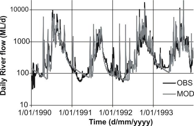
28 Calibration results
29 How does it compare to conventional lumped rainfall-runoff models?
30 Low flow analysis Predict river flow under various scenarios where recharge is scaled down (up to 40% with 5% increments) Assess impacts on flow using a number of low flow indices that include: (1) the slope of the low flow part of the Flow Duration Curve, is indicative of the sustainability of low flows whereby a steep curve indicates small and/or variable baseflow contribution (2) the percentage of zero-flow days in the record as the FDC has no regard to the sequence of occurrence, the % of zero-flow days illustrates the degree of stream intermittency
31 Impacts on low flows % Zero-flow days Zero-flow days Slope change % Slope change of low-flow part of cc FDCc % Reduction in recharge 0
32 Adding GW processes into river management models Reach-scale model that determines the exchange flux of water between a river and the underlying aquifer Applicable to regulated river systems Handles both gaining and losing (saturated and unsaturated) connections Dynamically models groundwater pumping, diffuse, irrigation and flood recharge, bank storage exchange, and evapotranspiration Allows fluxes or heads from external groundwater models (such as MODFLOW) to be passed to/from the model
33 Conceptualisation of SW-GW interaction processes in the Link Model Node1 (Upstream) We estimate the SW-GW exchange fluxes and heads due to individual processes then use superposition to evaluate the overall exchange flux at the end of every time step Link length L GW/SW exchange flux Processes depend on type of connection Node 2 (Downstream)
34 Cumulative Interaction Gaining river Processes modelled Overbank event Saturated connection Within bank event Infiltration, recharge, and discharge Bank storage Groundwater pumping Groundwater ET Irrigation recharge Node1 (Upstream) Losing river Groundwater table Link length L GW/SW exchange flux Losing river Unsaturated connection Processes depend on type of connection Recharge driven by difference in head between river and groundwater Node 2 (Downstream)
35 Explicit representation of SW-GW interactions results in a realistic calibration of the river model SW-GW fluxes Residual inflows without SW-GW fluxes Residual inflows with SW-GW fluxes Flow (ML/day) % Time exceeded or equaled


36 Significance of groundwater extractions on river/aquifer interaction


37 In summary: Incorporating SW-GW interaction into river modelling: Enhances low flow predictions Enhances forecasting capacity in areas with significant groundwater development 37 Presentation title Presenter name

38 Thank you.. CSIRO LAND AND WATER WATER FOR A HEALTHY COUNTRY FLAGSHIP David Rassam Hydrological Modeller Phone ( ) david.rassam@csiro.au
39 GW-SW Link Model input data Pumping schedules, pump locations from river and boundaries were identified
40 GW-SW Link Model input data Diffuse recharge Rates, areas, and their centroids were located
41 GW-SW Link Model input data Irrigation recharge Rates, areas, and their centroids were located

42 Namoi Basin trial Narrabri to Boggabri reach

43 Variability in river-aquifer connectivity
The Australian Water Resource Assessment Modelling System (AWRA)
") 20th International Congress on Modelling and Simulation, Adelaide, Australia, 1 6 December 2013 www.mssanz.org.au/modsim2013 The Australian Water Resource Assessment Modelling System (AWRA) J. Vaze a,
20th International Congress on Modelling and Simulation, Adelaide, Australia, 1 6 December 2013 www.mssanz.org.au/modsim2013 The Australian Water Resource Assessment Modelling System (AWRA) J. Vaze a,
Hydrologic Modeling Overview
 Hydrologic Modeling Overview Chuck Downer, PhD, PE Hydrologic Systems Branch Coastal and Hydraulics Laboratory Engineer Research and Development Center Vicksburg, Mississippi Hydrologic processes Hydrologic
Water Resources on PEI: an overview and brief discussion of challenges
 Water Resources on PEI: an overview and brief discussion of challenges Components: Components and links Atmospheric water Surface water (including glacial water) Groundwater Links: Precipitation (atm(
The Texas A&M University and U.S. Bureau of Reclamation Hydrologic Modeling Inventory (HMI) Questionnaire
 Questionnaire") The Texas A&M University and U.S. Bureau of Reclamation Hydrologic Modeling Inventory (HMI) Questionnaire May 4, 2010 Name of Model, Date, Version Number Dynamic Watershed Simulation Model (DWSM) 2002
The Texas A&M University and U.S. Bureau of Reclamation Hydrologic Modeling Inventory (HMI) Questionnaire May 4, 2010 Name of Model, Date, Version Number Dynamic Watershed Simulation Model (DWSM) 2002
CHAPTER FIVE Runoff. Engineering Hydrology (ECIV 4323) Instructors: Dr. Yunes Mogheir Dr. Ramadan Al Khatib. Overland flow interflow
 Instructors: Dr. Yunes Mogheir Dr. Ramadan Al Khatib. Overland flow interflow") Engineering Hydrology (ECIV 4323) CHAPTER FIVE Runoff Instructors: Dr. Yunes Mogheir Dr. Ramadan Al Khatib Overland flow interflow Base flow Saturated overland flow ١ ٢ 5.1 Introduction To Runoff Runoff
Engineering Hydrology (ECIV 4323) CHAPTER FIVE Runoff Instructors: Dr. Yunes Mogheir Dr. Ramadan Al Khatib Overland flow interflow Base flow Saturated overland flow ١ ٢ 5.1 Introduction To Runoff Runoff
Tools for Wetlands Permit Evaluation: Modeling Groundwater and Surface Water Interaction
 Tools for Wetlands Permit Evaluation: Modeling Groundwater and Surface Water Interaction Cary Talbot Coastal & Hydraulics Laboratory Example Wetland Permit Problem Applicant claimed proper drainage ditch
Texas A & M University and U.S. Bureau of Reclamation Hydrologic Modeling Inventory Model Description Form
 Texas A & M University and U.S. Bureau of Reclamation Hydrologic Modeling Inventory Model Description Form JUNE 18, 1999 Name of Model: MIKE 11 RR (Rainfall Runoff) Model Type: The MIKE 11 RR model is
Measuring discharge. Climatological and hydrological field work
 Measuring discharge Climatological and hydrological field work 1. Background Discharge (or surface runoff Q s) refers to the horizontal water flow occurring at the surface in rivers and streams. It does
Hydrology and Water Management. Dr. Mujahid Khan, UET Peshawar
 Hydrology and Water Management Dr. Mujahid Khan, UET Peshawar Course Outline Hydrologic Cycle and its Processes Water Balance Approach Estimation and Analysis of Precipitation Data Infiltration and Runoff
Lecture 9A: Drainage Basins
 GEOG415 Lecture 9A: Drainage Basins 9-1 Drainage basin (watershed, catchment) -Drains surfacewater to a common outlet Drainage divide - how is it defined? Scale effects? - Represents a hydrologic cycle
Flood forecasting model based on geographical information system
 doi:10.5194/piahs-368-192-2015 192 Remote Sensing and GIS for Hydrology and Water Resources (IAHS Publ. 368, 2015) (Proceedings RSHS14 and ICGRHWE14, Guangzhou, China, August 2014). Flood forecasting model
Numerical Groundwater Model for the Kaweah Delta Water Conservation District
 Numerical Groundwater Model for the Kaweah Delta Water Conservation District Nels Ruud and Peter Leffler Fugro West, Inc. Larry Dotson Kaweah Delta Water Conservation District Presentation Outline Background
Resolving uncertainties in the source of low flows in South African rivers using conceptual and modelling studies
 Conceptual and Modelling Studies of Integrated Groundwater, Surface Water, and Ecological Systems 127 (Proceedings of Symposium H1 held during IUGG211 in Melbourne, Australia, July 211) (IAHS Publ. 345,
Surface Nuclear Magnetic Resonance for non-invasive observation of the vadose zone
 Surface Nuclear Magnetic Resonance for non-invasive observation of the vadose zone Stephan Costabel and Ursula Noell 1 Federal Institute for Geosciences and Natural Resources, Dept. Groundwater and Soil
EFFECTS OF WATERSHED TOPOGRAPHY, SOILS, LAND USE, AND CLIMATE ON BASEFLOW HYDROLOGY IN HUMID REGIONS: A REVIEW
 PROGRESS IN PHYSICAL GEOGRAPHY EFFECTS OF WATERSHED TOPOGRAPHY, SOILS, LAND USE, AND CLIMATE ON BASEFLOW HYDROLOGY IN HUMID REGIONS: A REVIEW KATIE PRICE 2011 Presented by: Jordan Martin Article Overview
Event and Continuous Hydrological Modeling with HEC- HMS: A Review Study
 Event and Continuous Hydrological Modeling with HEC- HMS: A Review Study Sonu Duhan *, Mohit Kumar # * M.E (Water Resources Engineering) Civil Engineering Student, PEC University Of Technology, Chandigarh,
Hydrological investigations of surface water groundwater interactions in a sub-catchment in the Namoi Valley, NSW, Australia
 Trends and Sustainability of Groundwater in Highly Stressed Aquifers (Proc. of Symposium JS.2 at the Joint IAHS & IAH Convention, Hyderabad, India, September 2009). IAHS Publ. 329, 2009. 157 Hydrological
Surface groundwater connectivity assessment. A report to the Australian Government from the CSIRO Murray-Darling Basin Sustainable Yields Project
 Surface groundwater connectivity assessment A report to the Australian Government from the CSIRO Murray-Darling Basin Sustainable Yields Project S. Parsons, R. Evans and M. Hoban September 2008 Murray-Darling
Lecture 20: Groundwater Introduction
 Lecture 20: Groundwater Introduction Key Questions for Groundwater 1. What is an aquifer? 2. What is an unconfined aquifer? 3. What is groundwater recharge? 4. What is porosity? What determines the magnitude
Groundwater Models and Modeling Considerations
 Groundwater Models and Modeling Considerations MPCA Industrial Landfill Guidance Workgroup April 30, 2009 Terry Johnson, P.G. Waste Management Inc., The Three Legs of the Stool 1. Engineering design and
Subject: Peer review of Duntroon Quarry hydrogeologic modelling: Report #1
 ENVIRONMENTAL & WATER-RESOURCE CONSULTANTS June 5, 2008 Ms. Kathryn Pounder, MA, MCIP, RPP Niagara Escarpment Commission 232 Guelph Street Georgetown, Ontario L7G 4B1 Subject: Peer review of Duntroon Quarry
SURFACE WATER AND PHREATIC AQUIFER INTERACTION IN FLOODPLAIN WITH PADDY FIELD IN THAILAND
 SURFACE WATER AND PHREATIC AQUIFER INTERACTION IN FLOODPLAIN WITH PADDY FIELD IN THAILAND SOMBAT CHUENCHOOKLIN 1, TSUTOMU ICHIKAWA 2, SANGUAN PATAMATAMKUL 3, CHALONG KIRDPITUGSA 3, and VICHAI SRIBOONLUE
UNIT HYDROGRAPH AND EFFECTIVE RAINFALL S INFLUENCE OVER THE STORM RUNOFF HYDROGRAPH
 UNIT HYDROGRAPH AND EFFECTIVE RAINFALL S INFLUENCE OVER THE STORM RUNOFF HYDROGRAPH INTRODUCTION Water is a common chemical substance essential for the existence of life and exhibits many notable and unique
The Islamic University of Gaza- Civil Engineering Department Sanitary Engineering- ECIV 4325 L5. Storm water Management
 The Islamic University of Gaza- Civil Engineering Department Sanitary Engineering- ECIV 4325 L5. Storm water Management Husam Al-Najar Storm water management : Collection System Design principles The Objectives
South Platte Decision Support System Alluvial Groundwater Model Update Documentation
 EXECUTIVE SUMMARY Prepared for The Colorado Water Conservation Board and Division of Water Resources South Platte Decision Support System Alluvial Groundwater Model Update Documentation June 2017 All cover
Comparison of Recharge Estimation Methods Used in Minnesota
 Comparison of Recharge Estimation Methods Used in Minnesota by Geoffrey Delin, Richard Healy, David Lorenz, and John Nimmo Minnesota Ground Water Association Spring Conference Methods for Solving Complex
Review of the Hydrologic Cycle & Streamflow Generation
 Quantitative Elements of Physical Hydrology Review of the Hydrologic Cycle & Streamflow Generation (Review) Contact information: Jack Hermance Environmental Geophysics/Hydrology Department of Geological
Application of a Basin Scale Hydrological Model for Characterizing flow and Drought Trend
 Application of a Basin Scale Hydrological Model for Characterizing flow and Drought Trend 20 July 2012 International SWAT conference, Delhi INDIA TIPAPORN HOMDEE 1 Ph.D candidate Prof. KOBKIAT PONGPUT
Hydrologic cycle, runoff process
 Hydrologic cycle, runoff process Motivation of hydrological modelling What happens at the catchment and in the stream when it rains? How does the increased/decreased runoff affect (not only) the landowners
Definitions 3/16/2010. GG22A: GEOSPHERE & HYDROSPHERE Hydrology
 GG22A: GEOSPHERE & HYDROSPHERE Hydrology Definitions Streamflow volume of water in a river passing a defined point over a specific time period = VxA discharge m 3 s -1 Runoff excess precipitation - precipitation
Predicting Unmet Irrigation Demands due to Climate Change An integrated Approach in WEAP
 Predicting Unmet Irrigation Demands due to Climate Change An integrated Approach in WEAP Marc Haering Emad Al-Karablieh, Amer Salman University of Jordan G-Wadi International Session 5: Risks Assessment
Transboundary aquifers in Africa: Kilimanjaro Aquifer. Malte Grossmann
 Transboundary aquifers in Africa: Kilimanjaro Aquifer Malte Grossmann Context Research and consultancy study: cooperation on transboundary groundwater resources Presented at last Seminar Study is availabe
SOUTHERN AFRICAN FRIEND - RAINFALL-RUNOFF MODELLING.
 SOUTHERN AFRICAN FRIEND - RAINFALL-RUNOFF. D A Hughes, Institute for Water Research, Rhodes University, Grahamstown, South Africa. 1 Introduction The overall aim of the rainfall-runoff modelling component
Continuous Simulation Modeling of Stormwater Ponds, Lakes, & Wetlands: A BUILT-IN APPLICATION OF PONDS 3.2
 Continuous Simulation Modeling of Stormwater Ponds, Lakes, & Wetlands: A BUILT-IN APPLICATION OF PONDS 3.2 PRESENTED AT THE SFWMD WORKSHOP PRE-DEVELOPMENT VERSUS POST DEVELOPMENT RUNOFF VOLUME ANALYSIS
A simple model for low flow forecasting in Mediterranean streams
 European Water 57: 337-343, 2017. 2017 E.W. Publications A simple model for low flow forecasting in Mediterranean streams K. Risva 1, D. Nikolopoulos 2, A. Efstratiadis 2 and I. Nalbantis 1* 1 School of
Prediction for Natural Recharging In Langat Basin and Ukm Campus as Case Study
 Prediction for Natural Recharging In Langat Basin and Ukm Campus as Case Study 1 Mohaad Fawzi Al Ajlouni, 2 Rakmi Abd Rahman, 3 Abdul Ghani Rafek, 4 Mazlin Mokhtar, 5 Noor Ezlin Ahmad Basri 1, 5 Department
Note that the Server provides ArcGIS9 applications with Spatial Analyst and 3D Analyst extensions and ArcHydro tools.
 Remote Software This document briefly presents the hydrological and hydraulic modeling software available on the University of Nice Server with Remote Desktop Connection. Note that the Server provides
The hydrologic and hydraulic study of the behaviour of the Nyl River floodplain
 River Basin Management IV 149 The hydrologic and hydraulic study of the behaviour of the Nyl River floodplain C. F. B. Havenga 1, A. Jeleni 1, W. V. Pitman 2 & A. K. Bailey 2 1 Department of Water Affairs
Taking the pain out of the treatment train: continuous simulation modelling for integrated water management
 Engineers & Consultants Taking the pain out of the treatment train: continuous simulation modelling for integrated water management Stu Farrant & Reuben Ferguson, Morphum Environmental Limited Abstract
July, International SWAT Conference & Workshops
 Analysis of the impact of water conservation measures on the hydrological response of a medium-sized watershed July, 212 212 International SWAT Conference & Workshops ANALYSIS OF THE IMPACT OF WATER CONSERVATION
How Groundwater Interacts with Lakes and Streams
 How Groundwater Interacts with Lakes and Streams Ken Bradbury Wisconsin Geological and Natural History Survey University of Wisconsin-Extension AGI Critical Issues Webinar July 13, 2015 Groundwater basics
BAEN 673 / February 18, 2016 Hydrologic Processes
 BAEN 673 / February 18, 2016 Hydrologic Processes Assignment: HW#7 Next class lecture in AEPM 104 Today s topics SWAT exercise #2 The SWAT model review paper Hydrologic processes The Hydrologic Processes
Groundwater Resources Program Regional Groundwater Evaluation
 Groundwater Resources Program Regional Groundwater Evaluation Appalachian Plateaus Aquifer System Kurt McCoy, David Nelms Mark Kozar Richard Yager David Ladd USGS Virginia Water Science Center USGS West
1. Stream Network. The most common approach to quantitatively describing stream networks was postulated by Strahler (1952).
.") 1. Stream Network The most common approach to quantitatively describing stream networks was postulated by Strahler (1952). First Order Streams streams with no tributaries. Second Order Streams begin at
1. Stream Network The most common approach to quantitatively describing stream networks was postulated by Strahler (1952). First Order Streams streams with no tributaries. Second Order Streams begin at
Representing the Integrated Water Cycle in Community Earth System Model
 Representing the Integrated Water Cycle in Community Earth System Model Hong-Yi Li, L. Ruby Leung, Maoyi Huang, Nathalie Voisin, Teklu Tesfa, Mohamad Hejazi, and Lu Liu Pacific Northwest National Laboratory
Runoff and soil loss. (Quantification and modeling of watershed discharge and sediment yield) Kassa Tadele (Dr.Ing) Arba Minch University
 Kassa Tadele (Dr.Ing) Arba Minch University") Runoff and soil loss (Quantification and modeling of watershed discharge and sediment yield) Kassa Tadele (Dr.Ing) Arba Minch University Part I. Runoff Contents 1. Fundamental Concepts 2. Generation of
Runoff and soil loss (Quantification and modeling of watershed discharge and sediment yield) Kassa Tadele (Dr.Ing) Arba Minch University Part I. Runoff Contents 1. Fundamental Concepts 2. Generation of
Subject: Peer review of Duntroon Quarry hydrogeologic modelling: Report #2
 ENVIRONMENTAL & WATER-RESOURCE CONSULTANTS November 20, 2008 Ms. Kathryn Pounder, MA, MCIP, RPP Niagara Escarpment Commission 232 Guelph Street Georgetown, Ontario L7G 4B1 kathryn.pounder@ontario.ca Subject:
An Overview of JULES. Christina Bakopoulou
 An Overview of JULES Christina Bakopoulou JULES, MOSES AND TRIFFID JULES (Joint UK Land Environment Simulator) is a new land surface model Joint initiative: NERC through the CEH, CLASSIC, QUEST and the
HYDRAULIC HYDRODYNAMIC MODELING AS AN EFFECTIVE MANAGEMENT TOOL FOR LARGE COLLECTION SYSTEMS - THE L.A. STORY
 HYDRAULIC HYDRODYNAMIC MODELING AS AN EFFECTIVE MANAGEMENT TOOL FOR LARGE COLLECTION SYSTEMS - THE L.A. STORY Fernando Gonzalez, Adel Hagekhalil, Bryan Trussell, City of Los Angeles Bureau of Sanitation
Integrated Catchment Modelling
 Integrated Catchment Modelling Modelling the whole water cycle in one package Ann Pugh Integrated Water Planning Historically water, wastewater and stormwater modelling occurred in silos with little integration
Hydrological And Water Quality Modeling For Alternative Scenarios In A Semi-arid Catchment
 Hydrological And Water Quality Modeling For Alternative Scenarios In A Semi-arid Catchment AZIZ ABOUABDILLAH, ANTONIO LO PORTO METIER Final Conference: Brussels, Belgium-4-6 November 2009 Outline Problem
New Investments in Water Portfolios
 California Water Plan Update 2010 New Investments in Water Portfolios California Water and Environmental Water Forum Annual Meeting February 27, 2007 Todd Hillaire hillaire@water.ca.gov California Department
THE RATIONAL METHOD FREQUENTLY USED, OFTEN MISUSED
 THE RATIONAL METHOD FREQUENTLY USED, OFTEN MISUSED Mark Pennington, Engineer, Pattle Delamore Partners Ltd, Tauranga ABSTRACT The Rational Method has been in use in some form or another at least since
Literature Review: Groundwater in LSMs
 Literature Review: Groundwater in LSMs Lindsey Gulden Physical Climatology, 387H December, 2005 1. Abstract The review also briefly justifies the inclusion of physically based groundwater representations
API SOIL & GROUNDWATER RESEARCH BULLETIN
 American API SOIL & GROUNDWATER RESEARCH BULLETIN A summary of research results from API s Soil and Groundwater Technical Task Force. No. 2 March 1997 Estimation of Infiltration and Recharge for Environmental
Estimation of Actual Evapotranspiration at Regional Annual scale using SWAT
 Estimation of Actual Evapotranspiration at Regional Annual scale using SWAT Azizallah Izady Ph.D student of Water Resources Engineering Department of Water Engineering, Faculty of Agriculture, Ferdowsi
Advice to decision maker on coal mining project
 . Advice to decision maker on coal mining project IESC 2015-063: West Muswellbrook Project New Development Requesting agency The New South Wales Mining and Petroleum Gateway Panel Date of request 27 January
What is a representative pan factor value for the eastern Pilbara? Aditya Jha
 What is a representative pan factor value for the eastern Pilbara? Aditya Jha Parsons Brinckerhoff Australia Pty Ltd, Level 5, 503 Murray St, Perth, Western Australia 6000, AJha@pb.com.au Abstract The
Watershed Hydrology. a) Water Balance Studies in Small Experimental Watersheds
 Water Balance Studies in Small Experimental Watersheds") Watershed Hydrology a) Water Balance Studies in Small Experimental Watersheds In order to characterize the geometry of the regolith as well as the directions of the fractures or fissures in the protolith,
Watershed Hydrology a) Water Balance Studies in Small Experimental Watersheds In order to characterize the geometry of the regolith as well as the directions of the fractures or fissures in the protolith,
Water Table Monitoring Project Design
 Wetlands Regulatory Assistance Program ERDC TN-WRAP-06-2 Water Table Monitoring Project Design by Chris V. Noble PURPOSE: This document provides guidance for planning and implementing a wetland hydrology
Watershed hydrology and catchment response
 Watershed hydrology and catchment response Motivation Studying stream response to water input events (catchment response) is important for: Water supply: Precipitation falling in the ground and then moving
Assessment of Watershed Soundness by Water Balance Using SWAT Model for Han River Basin, South Korea
 2015 International SWAT Conference & Workshops October 12-16, 2015 Purdue University, USA SESSION A3: HYDROLOGY Room: Stewart 278 2015 International SWAT Conference Assessment of Watershed Soundness by
Chapter IV: SUMMARY OF MODEL DEVELOPMENT AND RESULTS. The quantity of runoff, precipitation, evaporation,
 Chapter IV: CONCLUSIONS SUMMARY OF MODEL DEVELOPMENT AND RESULTS The quantity of runoff, precipitation, evaporation, evapotranspiration, diversions, and storage changes in the Mono Basin and their annual
What is runoff? Runoff. Runoff is often defined as the portion of rainfall, that runs over and under the soil surface toward the stream
 What is runoff? Runoff Runoff is often defined as the portion of rainfall, that runs over and under the soil surface toward the stream 1 COMPONENTS OF Runoff or STREAM FLOW 2 Cont. The types of runoff
6.0 Runoff. 6.1 Introduction. 6.2 Flood Control Design Runoff
 October 2003, Revised February 2005 Chapter 6.0, Runoff Page 1 6.1 Introduction 6.0 Runoff The timing, peak rates of discharge, and volume of stormwater runoff are the primary considerations in the design
Information Requirements Table for Liquid Waste
 Applicant Summary Tracking # Authorization # Applicant / Facility Name Ministry of Environment Prepared by: Title Date The Information Requirements Table (IRT) for Liquid Waste is a tool used by Ministry
1.6 Influence of Human Activities and Land use Changes on Hydrologic Cycle
 1.6 Influence of Human Activities and Land use Changes on Hydrologic Cycle Watersheds are subjected to many types of changes, major or minor, for various reasons. Some of these are natural changes and
Fundamentals of modelling: The process and tools
 Fundamentals of modelling: The process and tools Water Modelling Overview Geoff Podger 10:00-10:45 (4:00-4:45) am Friday, 4 Nov 2016 BASIN MANAGEMENT OUTCOMES LAND AND WATER Contents Best Practice Modelling
Issue paper: Aquifer Water Balance
 Issue paper: Aquifer Water Balance 1. Introduction And Background 1.1. Purpose and Scope The population in Kitsap County has grown rapidly in recent years and is expected to increase substantially in the
URBAN FLOODING: HEC-HMS
 1.0 Introduction URBAN FLOODING: HEC-HMS -Sunil Kumar, Director, NWA All major ancient civilisations were developed in the river valleys because river served as source of water, food, transportation and
The surface water hydrology of the site has been logically divided into six phases of monitoring, analyses, and investigation as outlined below:
 SURFACE WATER HYDROLOGY The surface water hydrology of the site has been logically divided into six phases of monitoring, analyses, and investigation as outlined below: Sample Station Locations and Descriptions
Sterling and Gilcrest/LaSalle High Groundwater Analysis
 FINAL REPORT Prepared for The State of Colorado, Department of Natural Resources Sterling and Gilcrest/LaSalle High Groundwater Analysis July 2015 Sterling and Gilcrest/LaSalle High Groundwater Analysis
5. Water Budget Implementation Procedures
 5. Water Budget Implementation Procedures 5.1 General The purpose of the watershed level water budget is to determine the volume of surface and groundwater available for the benefit of both human populations
Application of SWAT Model in land-use. change in the Nile River Basin: A Review
 Application of SWAT Model in land-use change in the Nile River Basin: A Review By: Marwa Ali, Okke Batelaan and Willy Bauwens 15-6-2011 Application of SWAT Model in land-use 1 change in the Nile River
Hydrologic Cycle. Water Availabilty. Surface Water. Groundwater
 Hydrologic Cycle Hydrologic ydoogccyce cycle Surface Water Groundwater Water Availabilty 1 Hydrologic Cycle Constant movement of water above, on, and, below the earth s surface (Heath) Endless circulation
Overview of the Surface Hydrology of Hawai i Watersheds. Ali Fares Associate Professor of Hydrology NREM-CTAHR
 Overview of the Surface Hydrology of Hawai i Watersheds Ali Fares Associate Professor of Hydrology NREM-CTAHR 5/23/2008 Watershed Hydrology Lab 1 What is Hydrology? Hydrology is the water science that
Importance of irrigation return flow on the groundwater budget of a rural basin in India
 62 Hydrology of the Mediterranean and Semiarid Regions (Proceedings of an international symposium held at Montpellier. April 2003). IAHS Publ. no. 278. 2003. Importance of irrigation return flow on the
Runoff Processes. Daene C. McKinney
 CE 374 K Hydrology Runoff Processes Daene C. McKinney Watershed Watershed Area draining to a stream Streamflow generated by water entering surface channels Affected by Physical, vegetative, and climatic
RAINFALL - RUNOFF MODELING IN AN EXPERIMENTAL WATERSHED IN GREECE
 Proceedings of the 14 th International Conference on Environmental Science and Technology Rhodes, Greece, 3-5 September 2015 RAINFALL - RUNOFF MODELING IN AN EXPERIMENTAL WATERSHED IN GREECE KOTSIFAKIS
Integrated urban water systems modelling with a simplified surrogate modular approach
 Integrated urban water systems modelling with a simplified surrogate modular approach Z. Vojinovic 1 *, and S.D. Seyoum 2 Department of Hydroinformatics and Knowledge Management, UNESCO-IHE, Institute
Environmental Intelligence-Where To get the Data From?
 Environmental Intelligence-Where To get the Data From? Climate and Water Information and Services Dr. Amgad Elmahdi Manager Water Resources Assessment Section 24 July 2012 Presentation outline Bureau s
Hydrologic Calibration:
 Hydrologic Calibration: UPDATE OF EFFECTIVE HYDROLOGY FOR MARYS CREEK October 2010 Agenda Background Hydrologic model Calibrated rainfall Hydrologic calibration 100 year discharges, Existing Conditions
Relationships between low-flow characteristics of South African streams
 Relationships between low-flow characteristics of South African streams VY Smakhtin * and M Toulouse Institute for Water Research, Rhodes University, PO Box 94, Grahamstown, 64, South Africa Ecole Nationale
RAINFALL-RUNOFF STUDY FOR SINGAPORE RIVER CATCHMENT
 10 th International Conference on Hydroinformatics HIC 2012, Hamburg, GERMANY RAINFALL-RUNOFF STUDY FOR SINGAPORE RIVER CATCHMENT CHI DUNG DOAN (1)(3), JIANDONG LIU (1), SHIE-YUI LIONG (1), ADRI VERWEY
Water management innovation for meeting Climate change effects and European Water Framework Directive targets: Pilot study Lankheet
 Water management innovation for meeting Climate change effects and European Water Framework Directive targets: Pilot study Lankheet E.P. Querner, P.J.T. van Bakel and H.M. Mulder Alterra, Centre for Water
Water Availability in the Barwon-Darling
 Water Availability in the Barwon-Darling Summary of a report to the Australian Government from the CSIRO Murray-Darling Basin Sustainable Yields Project June 2008 Project framework Scenarios assessed The
CHAPTER 2. Objectives of Groundwater Modelling
 CHAPTER 2 Objectives of Groundwater Modelling In the last two decades mathematical modelling techniques have increasingly proved their value in furthering the understanding of groundwater systems and,
Rainfall - runoff: Unit Hydrograph. Manuel Gómez Valentín E.T.S. Ing. Caminos, Canales y Puertos de Barcelona
 Rainfall - runoff: Unit Hydrograph Manuel Gómez Valentín E.T.S. ng. Caminos, Canales y Puertos de Barcelona Options in many commercial codes,, HMS and others HMS Menu Transform method, User specified,
Summer School 2005 Rainfall Runoff Model KALYPSO-NA Exercise 3. Longterm Calibration
 Summer School 2005 Rainfall Runoff Model KALYPSO-NA Exercise 3 Longterm Calibration Montenegro, September 2005 In this exercise the long lasting processes of the hydrological cycle shall be calibrated
Modelling LIDs using PCSWMM and EPA SWMM5. March 28, 2012 Presented by: Rob James (CHI) Credit to: Lewis Rossman (US EPA)
 Credit to: Lewis Rossman (US EPA)") Modelling LIDs using PCSWMM and EPA SWMM5 March 28, 2012 Presented by: Rob James (CHI) Credit to: Lewis Rossman (US EPA) IBM PC/AT Intel 80-486 IBM PowerPC Intel Pentium III Intel Quad Core Intel i7 1977
Modelling LIDs using PCSWMM and EPA SWMM5 March 28, 2012 Presented by: Rob James (CHI) Credit to: Lewis Rossman (US EPA) IBM PC/AT Intel 80-486 IBM PowerPC Intel Pentium III Intel Quad Core Intel i7 1977
Review of existing simulation based flood frequency frameworks in Greece
 European Procedures for Flood Frequency Estimation FLOODFREQ COST ACTION ES0901 3 rd Management Committee Meeting, Prague, 28 29 October 2010 WG3: Use of rainfall runoff models for flood frequency estimation
2
 1 2 3 4 5 6 The program is designed for surface water hydrology simulation. It includes components for representing precipitation, evaporation, and snowmelt; the atmospheric conditions over a watershed.
CLIMATE CHANGE EFFECTS ON THE WATER BALANCE IN THE FULDA CATCHMENT, GERMANY, DURING THE 21 ST CENTURY
 CLIMATE CHANGE EFFECTS ON THE WATER BALANCE IN THE FULDA CATCHMENT, GERMANY, DURING THE 21 ST CENTURY Manfred Koch and Gabriel Fink Department of Geohydraulics and Engineering Hydrology, University of
MODELLING EFFECTS OF CLIMATE CHANGE AND URBANISATION ON SUPPLY RELIABILITY OF STORMWATER HARVESTING AND MANAGED AQUIFER RECHARGE
 MODELLING EFFECTS OF CLIMATE CHANGE AND URBANISATION ON SUPPLY RELIABILITY OF STORMWATER HARVESTING AND MANAGED AQUIFER RECHARGE Gonzalez, D. 1, Clark, R. 2, Dillon, P. 1, Charles, S. 3, Cresswell, D.
Wisconsin s Buried Treasure
 Wisconsin s Buried Treasure Kevin Masarik Center for Watershed Science and Education Through the University of Wisconsin-Extension, all Wisconsin people can access University resources and engage in lifelong
3.0 MANAGEMENT ISSUES AND RECOMMENDATIONS
 3.0 MANAGEMENT ISSUES AND RECOMMENDATIONS The purpose of this section is to describe some of the policies and issues related to the management of groundwater resources and identify recommended actions.
Context of Extreme Alberta Floods
 Context of Extreme Alberta Floods Introduction Design of water management and stream crossing infrastructure requires determination of hydrotechnical design parameters. These parameters often consist of
NBI strategic water resources analysis Phase I findings
 NBI strategic water resources analysis Phase I findings Abdulkarim H Seid NBI Secretariat The NBI Strategic Water Resources Analysis Key question: how to meet demands for water, food and energy upstream
The Fourth Assessment of the Intergovernmental
 Hydrologic Characterization of the Koshi Basin and the Impact of Climate Change Luna Bharati, Pabitra Gurung and Priyantha Jayakody Luna Bharati Pabitra Gurung Priyantha Jayakody Abstract: Assessment of
Use of the IQQM simulation model for planning and management of a regulated river system
 Integrated Water Resources Management (Proceedings of a symposium held al Davis. California. April 2000). IAHS Publ. no. 272, 2001. 83 Use of the IQQM simulation model for planning and management of a