Development and application of SUDSLOC in Birmingham A GIS-based SUDS selection tool for urban surface water management
|
|
|
- Randolph Ramsey
- 6 years ago
- Views:
Transcription

1 Development and application of SUDSLOC in Birmingham A GIS-based SUDS selection tool for urban surface water management C. Viavattene*, J. Bryan Ellis ** *Flood Hazard Research Centre **Urban Pollution research Centre Middlesex University London, UK Contact : c.viavattene@mdx.ac.uk The Future of Urban Water: Solutions for Livable and Resilient Cities
2 Challenges WFD - Flood directive Sustainable development Uncertainty (CC, Urban growth, Financial crisis...) Surface Water Management in the Urban Environment UK : Summer floods 2007 Floods and Water Bill Surface water management plan Identify the flood risk Long-term strategy to reduce the flood risk Stakeholders involvement SUDS (Sustainable Urban Drainage System)
3 K.I.S.S.? Urban storm water models Good representation of the physical phenomena but non-user friendly and complex as limited to technical issues SUDS Wide range of structures, impacts on water quantity and quality, of technical constraints, of costs and benefits Stakeholders Diverse with different knowledge, skills and role
4 TOOLS TO MANAGE LOCAL FLOOD RISK AND IDENTIFY CRITICAL DRAINAGE AREAS where flooding will occur and HOW opportunities for mitigating - SUDS measures improved public/stakeholder engagement assist forward emergency planning
5 DSS and SUDSLOC Is a Geographic Information Decision System Support tool Provides support for the identification and location of appropriate SUDS at urban scale Supports the integration of data (quantitative and qualitative) from a variety of sources to enable the investigation of the potential benefits of SUDS Incorporates user-friendly tools to ensure simplicity and ease of communication Requires relatively few skills in GIS (once the spatial data are ready to use) Is designed to communicate with storm modelling approach
6 SUDSLOC TOOL STRUCTURE Case study GIS data Land use Ground water Topographic Pollutant Network SUDS DECISION SUPPORT FRAMEWORK MANAGER Information Support System SUDS SUDS Characteristics Site criteria Multi criteria Indicators and benchmarking Pollutant removal Potential shp, ascii, SQL Storm water Models

7 SUDSLOC TOOL STRUCTURE Case study GIS data GIS INTERFACE Information Support System USER-FRIENDLY INTERFACE SUDS Land use Ground water Topographic Pollutant Network SUDS DECISION SUPPORT FRAMEWORK MANAGER SUDS Characteristics Site criteria Multi criteria Indicators and benchmarking Pollutant removal Potential shp, ascii, SQL Storm water Models
8 SUDS assessment component Site Criteria Land use, soil type, slope, depth to groundwater, drainage area, presence of flat roof Scale unit : road, park, building, pavement SUDS pollutant removal potential (Ranking) Pollutant (TSS, BOD, COD, Nitrates, Phosphates, Cd, Cu,...) Removal Process (adsorption, settling, microbial degradation, filtration, plant uptake, volatilisation and photolysis) Multi-Criteria Comparator (Ranking) Technical, environmental, economic, operation and maintenance, social and legal criteria Catalogue of information

9 Multi Criteria Comparator
10 Interactive Map functionalities Potential Areas Site-by-site assessment Add a SUDS and export

11


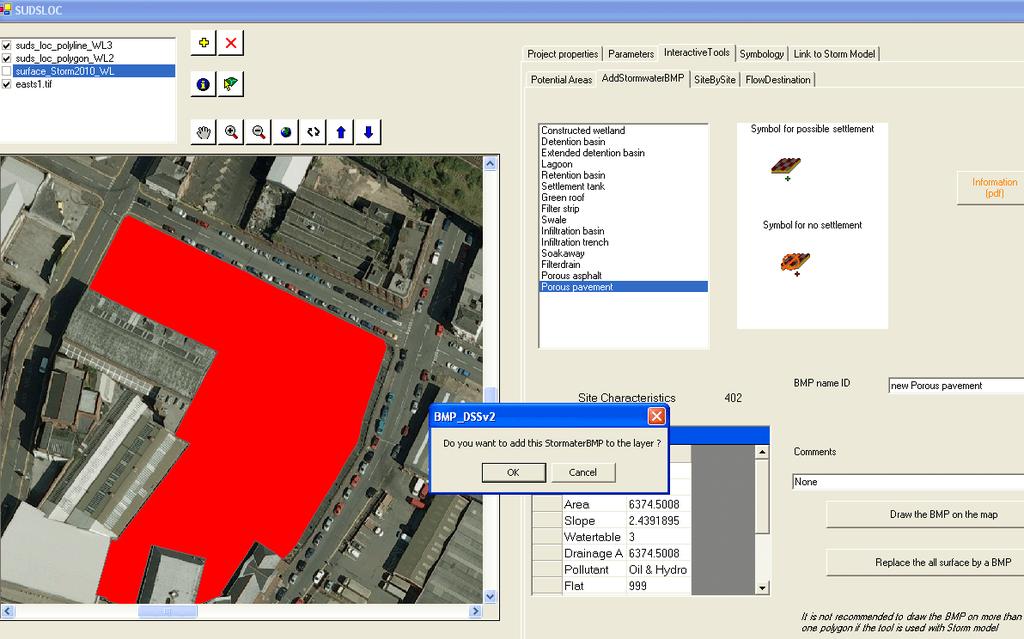
12 Interactive Map functionalities Potential Areas Site-by-site assessment Add a SUDS and export Flow destination


13 1D/2D COUPLED MODELLING FOR SURFACE PLUVIAL FLOODING SUDSLOC Informed decision Site selection SUDS characteristics SQL STORM.XXL model FLOOD AREA 2D visualisation
14 Application Birmingham Eastside Identifying Critical Drainage Areas: Identify hotspot flooding during extreme storm events Quantify depth and spatial distribution of flooding Identify flood flow paths Identify appropriate temporary storage, attenuation and treatment facilities


15 Eastside 12 ha Dense urban area Old industry new development Pluvial surface water flooding PREDICTED FLOW DISTRIBUTION AND EXCEEDANCE OVERFLOWS FOR AN EXTREME EVENT (STORM model)


")

16 LiDAR MOBILE SURVEY Raster Cell 0.1m (Arup)

17 Summer flood June 2007

18 WHAT SUDS DRAINAGE CONTROLS AND WHERE TO LOCATE THEM???? SUDSLOC model


19 PP GR IT In total decrease from 1240 to 838 m 3 (pipe12)
20 CONCLUSIONS - Accurate, robust methodology for identifying and quantifying local hotspot surface water (pluvial) flooding associated with extreme storm events - Identifies critical drainage areas - Provides methodological basis for preparation of emergency flood planning (e.g. safe access/escape routes, evacuation etc..) - Basis for selecting and locating appropriate SUDS drainage controls for the mitigation of extreme event surface flooding and pollution impacts - Provides flexible communication tool for stakeholder and public consultation and information on flood procedures and mitigation measures
21 Thank you
Adaptation planning at different spatial scales
 Adaptation planning at different spatial scales Using TCPA Publication Adaptation by Design as the main source GerGerry Metcalf UKCIP UKCIP Key adaptation principles for planning UKCIP Seek opportunities
Adaptation planning at different spatial scales
 Adaptation planning at different spatial scales Using TCPA Publication Adaptation by Design as the main source GerGerry Metcalf UKCIP UKCIP Key adaptation principles for planning UKCIP Seek opportunities
Integrating Soil Data into New Zealand Hydrological Models results of a user survey. Survey October, 2014
 Integrating Soil Data into New Zealand Hydrological Models results of a user survey Survey October, 2014 Joseph POLLACCO 1. Objectives of survey The objective of this survey was to establish the current
Improving Urban Resilience: the Blue- Green Advantage
 Improving Urban Resilience: the Blue- Green Advantage Image credit: Arup Dr Emily O Donnell emily.o donnell@nottingham.ac.uk CIBSE Resilient Cities Group Meeting 21st March 2016 bluegreencities.ac.uk EPSRC
BS8582, Code of Practice for Surface Water Management for Development Sites
 BSI Draft Review BS8582, Code of Practice for Surface Water Management for Development Sites Code of Practice for Surface Water Management Comment: The introduction of a specific British Standard which
Future Resilient Transport Networks
 Future Resilient Transport Networks Prof Chris Baker Birmingham Centre for Railway Research and Education Transport Systems Catapult (with thanks to Dr Andrew Quinn) Change is normal EU roadmap Future
Flood hazard assessment in the Raval District of Barcelona using a 1D/2D coupled model
 9 th International Conference on Urban Drainage Modelling Belgrade 2012 Flood hazard assessment in the Raval District of Barcelona using a 1D/2D coupled model Beniamino Russo, David Suñer, Marc Velasco,
BARRIERS TO THE SUCCESSFUL PROJECT MANAGEMENT AND IMPLEMENTATION OF SUSTAINABLE DRAINAGE SYSTEMS IN NORTHERN IRELAND
 BARRIERS TO THE SUCCESSFUL PROJECT MANAGEMENT AND IMPLEMENTATION OF SUSTAINABLE DRAINAGE SYSTEMS IN NORTHERN IRELAND Dissertation for MSc in Construction & Project Management Literature Review Stakeholders
Developers Guide for Surface Water Management.
 Developers Guide for Surface Water Management www.southwark.gov.uk Contents 1. Introduction... 2 2. Requirements for Flood Risk Assessments and Drainage Strategies... 3 2.1 Planning Applications... 3 2.2
Middlesex University Research Repository
 Middlesex University Research Repository An open access repository of Middlesex University research http://eprints.mdx.ac.uk Ellis, John Bryan and Revitt, D. Mike and Scholes, Lian N. L. (2010) A risk
What can Natural Capital do for our urban environments?
 What can Natural Capital do for our urban environments? Greater Manchester Natural Capital Group Annual Conference Wednesday 1 st Feb 2017 The Lowry 9.30 16.30 Join the conversation #gmnaturalcapital Workshop
Isle of Wight Strategic Flood Risk Assessment MK2. Appendix P Newport
 Isle of Wight Strategic Flood Risk Assessment MK2 Appendix P June 2010 Isle of Wight Strategic Flood Risk Assessment Overview Please review this discussion in conjunction with the mapping provided in this
Managing Adaptive REsponses to changing flood risk, Work Package 2 MARE City Partner Priorities
 Managing Adaptive REsponses to changing flood risk, Work Package 2 MARE City Partner Priorities University of Sheffield in collaboration with the partners of the MARE project FV 121214 Compiled by: John
21 ST CENTURY DRAINAGE PROGRAMME CAPACITY ASSESSMENT FRAMEWORK EXECUTIVE SUMMARY
 21 ST CENTURY DRAINAGE PROGRAMME CAPACITY ASSESSMENT FRAMEWORK EXECUTIVE SUMMARY Report Ref. No. 21CDP.CAF Programme Area & Reference Report Title Project Management Contractor Sub-Contractor Author of
GreenPlan Modeling Tool User Guidance
 GreenPlan Modeling Tool User Guidance Prepared by SAN FRANCISCO ESTUARY INSTITUTE 4911 Central Avenue, Richmond, CA 94804 Phone: 510-746-7334 (SFEI) Fax: 510-746-7300 www.sfei.org Table of Contents 1.
International approaches to the hydraulic control of surface water runoff in mitigating flood and environmental risks
 International approaches to the hydraulic control of surface water runoff in mitigating flood and environmental risks AWRA2016 (Orlando) David Powers (Woods Ballard, Udale-Clarke, Kellagher, Dou, Gerolin,
Report Work Package 3
 Report Work Package 3 By Susana Ochoa-Rodríguez RainGain Project Consortium Meeting, Exeter, 7 th October 2014 WP3: Urban pluvial flood modelling and prediction General Objective of WP3: To implement rainfall
Decision Making Tools:
 Decision Making Tools: Overview Scenarios Climate change Population growth Energy minimisation Making space for water Industrial transformation Regeneration Policy revisions Strategies SUDS Water saving
Integrated Catchment Modelling
 Integrated Catchment Modelling Modelling the whole water cycle in one package Ann Pugh Integrated Water Planning Historically water, wastewater and stormwater modelling occurred in silos with little integration
In order to develop these comprehensive watershed retrofit plans, six key tasks were undertaken, each of which is described further below:
 Date: June 26, 2013 To: From: Christin Jolicoeur, Watershed Planner Jason Papacosma, Watershed Programs Manager Arlington County Department of Environmental Services Laura Gardner, Water Resources Engineer
(1) Bridge, Road and Railway (Adaptation Project) (2) Bridge, Road and Railway (BAU Development with Adaptation Options)
 Bridge, Road and Railway (Adaptation Project) (2) Bridge, Road and Railway (BAU Development with Adaptation Options)") Sub-sector Guideline: (1) Bridge, Road and Railway (Adaptation Project) (2) Bridge, Road and Railway (BAU Development with Adaptation Options) Basic Concept A. General Concept Climate change will increase
Sub-sector Guideline: (1) Bridge, Road and Railway (Adaptation Project) (2) Bridge, Road and Railway (BAU Development with Adaptation Options) Basic Concept A. General Concept Climate change will increase
East Riding of Yorkshire Council STRATEGIC FLOOD RISK ASSESSMENT (SFRA) Level 1. APPENDIX C Surface Water Flood Hazard Mapping
 Level 1. APPENDIX C Surface Water Flood Hazard Mapping") APPENDIX C Surface Water Flood Hazard Mapping (this page intentionally left blank) Introduction Surface water or pluvial flooding can be defined as flooding which results from rainfall generated overland
APPENDIX C Surface Water Flood Hazard Mapping (this page intentionally left blank) Introduction Surface water or pluvial flooding can be defined as flooding which results from rainfall generated overland
Sustainability Criteria for the Design of Stormwater Drainage Systems for the 21 st Century
 Sustainability Criteria for the Design of Stormwater Drainage Systems for the 21 st Century R. Kellagher 1 and H. Udale-Clarke 1 * 1 HR Wallingford Ltd., Howbery Park, Wallingford. Oxfordshire, OX10 8BA,
Stormwater: Too Simple?
 Stormwater: Too Simple? Getting Closer to Advertised Level of Service Brandon Klenzendorf, Ph.D., P.E. 13 December 2017 - CWEA Fall Seminar Introduction Traditional approaches to solving stormwater problems
Challenge 2: Community Resilience in Dania Beach
 University of New Orleans ScholarWorks@UNO Coastal Resilience Workshop Coastal Resilience Workshop 2015 Oct 27th, 1:00 PM - 1:15 PM Challenge 2: Community Resilience in Dania Beach Samantha Danchuk Environmental
Chapter 7 : Conclusions and recommendations
 Chapter 7 : Conclusions and recommendations 7.1 Conclusions The main goal of this research was to investigate the modelling and rainfall data requirements for the design of combined sewer systems and the
Presentation Overview
 1 Mission Lead to provide the water sector (drinking water, wastewater, and storm water) with the practical tools, training, and technical assistance needed to adapt to climate change by promoting a clear
Modeling the Hydrologic Impacts of Control Structures Utilizing LiDAR, ICPR, and GIS Technologies
 Modeling the Hydrologic Impacts of Control Structures Utilizing LiDAR, ICPR, and GIS Technologies Keanan Bell NorthStar June 12, 2015 Project began in 2010 as a Hydrology Assessment and Conceptual Restoration
Net Present Value of Low Impact Development Retrofits in Edmonton, AB
 Net Present Value of Low Impact Development Retrofits in Edmonton, AB MN Water Resources Conference October 16 th, 2018 Brett H. Emmons, PE, ENV SP, LEED AP Principal + Water Resource Engineer, EOR Introductions
The use of constructed wetlands for reducing the impacts of urban surface runoff on receiving water quality
 Impacts of Urban Growth on Surface Water and Groundwater Quality (Proceedings of 1UGG 99 Symposium HS5. Birmingham, July 1999). IAHS Publ. no. 259, 1999. 349 The use of constructed wetlands for reducing
Critical infrastructures and risk assessment for climate change
 Critical infrastructures and risk assessment for climate change Alex Coletti, Antonio De Nicola, Maria Luisa Villani, and Tom DeFelice A ABSTRACT Access to reliable information on technological systems
Climate change impacts on rainfall extremes and urban drainage & needs for climate adaptation
 Climate change impacts on rainfall extremes and urban drainage & needs for climate adaptation Patrick Willems KU Leuven hydraulics division Patrick.Willems@bwk.kuleuven.be INTERNATIONAL GROUP ON URBAN
Isle of Wight Strategic Flood Risk Assessment MK2. Appendix E West Wight
 Isle of Wight Strategic Flood Risk Assessment MK2 Appendix E June 2010 Isle of Wight Strategic Flood Risk Assessment Overview The RDA is comprised of the towns of Totland and Freshwater and is classified
Webinar Overview. Presenter: Moderator: Length of Webinar: (1) hour Questions: For More Information or Comments: Amanda Ludlow Principal Scientist
 hour Questions: For More Information or Comments: Amanda Ludlow Principal Scientist") Webinar Overview Presenter: Amanda Ludlow Principal Scientist Moderator: Tanya Bissell Length of Webinar: (1) hour Questions: Mid & Post Presentation Please submit via the viewing panel For More Information
Webinar Overview Presenter: Amanda Ludlow Principal Scientist Moderator: Tanya Bissell Length of Webinar: (1) hour Questions: Mid & Post Presentation Please submit via the viewing panel For More Information
Is this the right tool for your needs? Lester McKee San Francisco Estuary Institute (SFEI) May 2001
 May 2001") The use of the Simple Model for informing environmental science and management: Is this the right tool for your needs? Lester McKee San Francisco Estuary Institute (SFEI) May 2001 Fact: Field data collection
The use of the Simple Model for informing environmental science and management: Is this the right tool for your needs? Lester McKee San Francisco Estuary Institute (SFEI) May 2001 Fact: Field data collection
The SuDS Manual Frequently asked questions
 The SuDS Manual Frequently asked questions 1. Is source control still a requirement of the new SuDS Manual? Yes. Source control components are fundamental elements of a SuDS scheme. The benefits of source
Middlesex University Research Repository
 Middlesex University Research Repository An open access repository of Middlesex University research http://eprints.mdx.ac.uk Ellis, John Bryan and Revitt, D. Mike and Lundy, Lian (2012) An impact assessment
Storm Water Management
 Storm Water Management Policy September 2014 2 Sustainable drainage feature designed to control and manage flows through a series of check dams 3 Document Name: Storm Water Management Controlled Copy No:
Protecting and Enhancing Ecosystem Services the Role of Wetlands and Watershed Management in Flood Attenuation Dr. Mark Gloutney Director Regional
 Protecting and Enhancing Ecosystem Services the Role of Wetlands and Watershed Management in Flood Attenuation Dr. Mark Gloutney Director Regional Operations Eastern Canada April 14 2016 Changes in Storm
The Sorsogon City experience in Promoting Risk Resilient Housing
 3 rd Global Forum on Urban Resilience and Adaptation The Sorsogon City experience in Promoting Risk Resilient Housing Bonn, Germany 14 May 2012 Challenge: V&AA findings Exposure of houses to climate change
Recent development and application of a rapid flood spreading method
 Flood Risk Management: Research and Practice Samuels et al. (eds) 2009 Taylor & Francis Group, London, ISBN 978-0-415-48507-4 Recent development and application of a rapid flood spreading method Julien
Asset Management of the Railway Slope Network and the Relevance to Irish Roads
 Asset Management of the Railway Slope Network and the Relevance to Irish Roads Paul Doherty and Catherine Joyce, 28 th September 2016 Iarnród Éireann Irish Rail Network 2,800 km Track 3,700 Cuttings &
Flood Risk and Drainage Assessment.
 Flood Risk and Drainage Assessment. Change of Use off land to Leisure Complex At, Caersws, Powys, SY17 5SB October 2018 Statement prepared for: Mr T Bebb By Woodsyde Developments Ltd Woodsyde Developments
Climate Change in Europe s Cities
 in Europe s Cities Copernicus for Climate Adaptation and Mitigation Copernicus EU Copernicus EU Copernicus EU www.copernicus.eu WHY IS COPERNICUS NEEDED IN EUROPE S CITIES? Climate Copernicus Climate Service
Water Quality Modeling for TMDLs: A Functional Overview. Kyle Hall Senior Water Resources Engineer October 14, 2015
 Water Quality Modeling for TMDLs: A Functional Overview Kyle Hall Senior Water Resources Engineer October 14, 2015 My Goal To provide a general overview of water quality modeling with two objectives: Be
In order to develop these comprehensive watershed retrofit plans, six key tasks were undertaken, each of which is described further below:
 Date: December 12, 2011 To: From: Re: Jason Papacosma, Watershed Planner Christin Jolincoeur, Watershed Planner Arlington County Department of Environmental Services Gregory Hoffmann, P.E., Program Director
Weathering the Storm: Wetlands and Food Attenuation in Ontario. Natural Adaptation to a Changing Climate
 Weathering the Storm: Wetlands and Food Attenuation in Ontario Natural Adaptation to a Changing Climate Ducks Unlimited Canada Our MISSION: DUC conserves, manages and restores wetlands and associated habitats
Catchment Scale Stormwater Volume and Pollutant Loading Analyses. Guidance for Municipal Stormwater Program Assessment and Prioritization
 Catchment Scale Stormwater Volume and Pollutant Loading Analyses Guidance for Municipal Stormwater Program Assessment and Prioritization May 2016 Catchment Scale Stormwater Volume and Pollutant Loading
United Utilities Integrated Catchment Approach
 United Utilities Integrated Catchment Approach Addressing water issues as part of a catchment based approach Institute of Water Autumn Seminar Thursday 23 rd November 2017 United Utilities Integrated Catchment
CENTRALIZED BMPS TYPICALLY PUBLICLY OWNED & MAINTAINED BMPS, TREATING A LARGE (>20 ACRES) URBAN DRAINAGE WITH MULTIPLE LAND
 URBAN DRAINAGE WITH MULTIPLE LAND") BMP RAM BMP Type Definitions 1 CENTRALIZED BMPS TYPICALLY PUBLICLY OWNED & MAINTAINED BMPS, TREATING A LARGE (>20 ACRES) URBAN DRAINAGE WITH MULTIPLE LAND USES AND OWNERSHIP STRUCTURAL BMP TYPE OTHER NAMES
BMP RAM BMP Type Definitions 1 CENTRALIZED BMPS TYPICALLY PUBLICLY OWNED & MAINTAINED BMPS, TREATING A LARGE (>20 ACRES) URBAN DRAINAGE WITH MULTIPLE LAND USES AND OWNERSHIP STRUCTURAL BMP TYPE OTHER NAMES
Assessment of Photovoltaic Potential in Residential Area Scharnhauser Park
 Assessment of Photovoltaic Potential in Residential Area Scharnhauser Park Aneta Strzalka, 1,a, Ursula Eicker 2,b and Roman Ulbrich 3,c 1,2 Centre for Applied Research of Sustainable Energy Technology,
How Outcomes are Changing Modelling. Steve Hogg
 How Outcomes are Changing Modelling Steve Hogg Introduction Background to Regulatory Challenges How that impacts on Modelling How we can / are responding to the challenge AMP6 Focus on Outcomes Outcomes
Hydromodification Computer Modeling
 Hydromodification Computer Modeling Douglas Beyerlein, P.E. Clear Creek Solutions, Inc. 15800 Village Green Drive #3 Mill Creek, WA 98012 beyerlein@clearcreeksolutions.com Phone: 425.892.6454 Introduction
Section 1 - Introduction
 VERSION 1.0 Stormwater Solutions for Residential Sites Section 1 - Introduction Prepared for EcoWater Solutions A Department of Waitakere City Council 113 Central Park Drive Henderson WAITAKERE CITY November
Fremont Tree Well Filters LID Performance on a Redeveloped Urban Roadway
 Fremont Tree Well Filters LID Performance on a Redeveloped Urban Roadway Site Summary Project Features Subsurface-Loaded Surface-Loaded The Fremont Low Impact Development Tree Well Filter pilot project
9th IWA Symposium on Systems Analysis and Integrated Assessment June 2015 Gold Coast, Queensland, Australia
 9th IWA Symposium on Systems Analysis and Integrated Assessment 14-17 June 2015 Gold Coast, Queensland, Australia Haiwei Huang, Siyu Zeng, Xin Dong, Pengfei Du School of Environment Tsinghua University,
National Programme on Flood Prevention, Protection and Mitigation. INBO Conference, Sibiu, ROMANIA
 National Programme on Flood Prevention, Protection and Mitigation Altan ABDULAMIT MESD Daniela RADULESCU NIHWM INBO Conference, Sibiu, ROMANIA - Content - National Programme on Flood Prevention, Protection
SWITCH and the Paradigm Shift
 SWITCH and the Paradigm Shift First joint project ever between a UN organization and the European Commission AIMS Sustainable urban Water management In The City of the futures Health Launched at World
Surface Water Management Masterplan. Summary and Actions. September 2016
 Surface Water Management Masterplan Summary and Actions September 2016 Contents Section Page 1. MGSDP Area and Partners 1 2. MGSDP Objectives, Vision and Guiding Principles 3 3. Surface Water Management
SINGAPORE S CLIMATE CHANGE STRATEGY
 SINGAPORE S CLIMATE CHANGE STRATEGY Presented by: Hum Wei Mei Assistant Director, Economic Research National Climate Change Secretariat Prime Minister s Office Singapore s National Circumstances Small
Shelbyville, Kentucky Stormwater Best Management Practices (BMPs) Stormwater Pollution Treatment Practices (Structural) DRAFT
 Stormwater Pollution Treatment Practices (Structural) DRAFT") Shelbyville, Kentucky Stormwater Best Management Practices (BMPs) Stormwater Pollution Treatment Practices (Structural) Activity: Infiltration Systems PLANNING CONSIDERATIONS: Design Life: Short IS Acreage
Shelbyville, Kentucky Stormwater Best Management Practices (BMPs) Stormwater Pollution Treatment Practices (Structural) Activity: Infiltration Systems PLANNING CONSIDERATIONS: Design Life: Short IS Acreage
Implementation of the methodology for climate change assessment for stormwater management in the Barcelona case study
 Implementation of the methodology for climate change assessment for stormwater management in the Barcelona case study Xavier Aldea, CETaqua Beniamino Russo, CLABSA Marc Velasco, CETaqua David Sunyer, CLABSA
Surface Water Guidance for Developers
 Surface Water Guidance for Developers Contents Overview of Sustainable Drainage Systems (SuDS)... 2 Information Required in a Flood Risk Assessment or Drainage Strategy... 3 Outline Planning Applications...
Storm Water Management Pollution and Treatment
 7th EWA Bruxells Conference 25.10.2011 Effektive Urban Wastewater Treatment Theo G. Schmitt, University of Kaiserslautern Storm Water Management Pollution and Treatment 10.11.2011-2 Overview Major Storm
Shaping a better built and natural environment for people to live, work, learn and play
 Shaping a better built and natural environment for people to live, work, learn and play Saxon House Office, Chelmsford Make 50 Years of Experience Count MLM is a leading multidisciplinary design, compliance
(1) Coastal Protection (Adaptation Project) (2) Coastal Protection (BAU Development with Adaptation Options)
 Coastal Protection (Adaptation Project) (2) Coastal Protection (BAU Development with Adaptation Options)") Sub-sector Guideline: (1) Coastal Protection (Adaptation Project) (2) Coastal Protection (BAU Development with Adaptation Options) Basic Concept A. General Concept B. Vulnerability Climate change will
Sub-sector Guideline: (1) Coastal Protection (Adaptation Project) (2) Coastal Protection (BAU Development with Adaptation Options) Basic Concept A. General Concept B. Vulnerability Climate change will
RTPI Flooding & SUDS. Implementing Flood Management. Christian Lomax - AECOM. Structure of Presentation. Introduction. Background
 RTPI Flooding & SUDS Implementing Flood Management Christian Lomax - AECOM Structure of Presentation Introduction Background Working in Partnership Water Cycle Studies Surface Water Management Plans AECOM
Modelling Stormwater Contaminant Loads in Older Urban Catchments: Developing Targeted Management Options to Improve Water Quality
 Modelling Stormwater Contaminant Loads in Older Urban Catchments: Developing Targeted Management Options to Improve Water Quality Frances J. CHARTERS 1, Thomas A. COCHRANE 1, Aisling D. O SULLIVAN 1 1
Dr. Sreeja P. Assistant Professor Department of Civil Engineering IIT Guwahati
 Urban Watershed Management Dr. Sreeja P. Assistant Professor Department of Civil Engineering IIT Guwahati Watershed Land area from which all water drains, flow to a destination such as a river, pond, stream,
APPENDIX E APPENDIX E ESTIMATING RUNOFF FOR SMALL WATERSHEDS
 APPENDIX E ESTIMATING RUNOFF FOR SMALL WATERSHEDS March 18, 2003 This page left blank intentionally. March 18, 2003 TABLES Table E.1 Table E.2 Return Frequencies for Roadway Drainage Design Rational Method
Infiltration Trench Factsheet
 Infiltration Trench Factsheet Infiltration Trench is a practice that provides temporary storage of runoff using the void spaces within the soil/sand/gravel mixture that is used to backfill the trench for
Dynamic Inundation Mapping for Emergency Planning and Disaster Response
 Dynamic Inundation Mapping for Emergency Planning and Disaster Response Ross Gordon, LEED AP October 29, 2008 Presentation Overview Introduce MIKE FLOOD Rice / TMC Case Study Emergency Planning Disaster
Bristol City Surface Water Management Plan Development and Application. Patrick Goodey Bristol City Council Paul Davies Ove Arup & partners Ltd
 Bristol City Surface Water Management Plan Development and Application Patrick Goodey Bristol City Council Paul Davies Ove Arup & partners Ltd City of Bristol Bristol city, population of over 433,000 incorporating
Stormwater Management Fact Sheet: Porous Pavement
 Stormwater Management Fact Sheet: Porous Pavement Description Porous pavement is a permeable pavement surface with an underlying stone reservoir that temporarily stores surface runoff before infiltrating
Biggars Lane Landfill Expansion Environmental Assessment Stormwater Management Assessment County of Brant
 R.J. Burnside & Associates Limited 17345 Leslie Street, Suite 200 Newmarket ON L3Y 0A4 CANADA telephone (905) 953-8967 fax (905) 953-8945 web www.rjburnside.com Technical Memorandum Date: Project Name:
Tools Quantifying the Benefits and Life Cycle Costs of Green Infrastructure Sakshi Saini
 Tools Quantifying the Benefits and Life Cycle Costs of Green Infrastructure Sakshi Saini Latornell Conference November 17, 2016 Outline Background Tools: 1. Low Impact Development Treatment Train Tool
APPENDIX E ESTIMATING RUNOFF FROM SMALL WATERSHEDS
 ESTIMATING RUNOFF FROM SMALL WATERSHEDS June 2011 THIS PAGE LEFT BLANK INTENTIONALLY. June 2011 TABLES Table E.1 Table E.2 Return Frequencies for Roadway Drainage Design Rational Method Values June 2011
Under a Changing Climate:
 Engineering Methods for Precipitation Under a Changing Climate: Outline of the Problem J. Rolf Olsen Institute for Water Resources U.S. Army Corps of Engineers Alexandria, Virginia ASCE Committee on Adaptation
FLOOD DAMAGE ASSESSMENT OF YIZHUANG, BEIJING
 FLOOD DAMAGE ASSESSMENT OF YIZHUANG, BEIJING Yuwen Zhou 1,*, Zilong Liu 1, Shanshan Liu 1, Jian Zhao 1, Wei Li 2, Jing Zhang 2, Albert S. Chen 3 1 Beijing University of Technology, China, 2 Hebei University
VILLAGE OF DEERFIELD Site Grading and Drainage Ordinance User Guide
 June 15, 2009 PURPOSE This has been prepared to assist in the uniform interpretation of the subject ordinance. These requirements and procedures establish a basis for the Village to utilize in the administration
Community Resiliency : What is it? Khris Dodson & Mary Austerman
 Community Resiliency : What is it? Khris Dodson & Mary Austerman A resilient community is one in which residents and institutions have the capacity to prepare for, respond to, and recover from events and
Public Engagement in Nature- Based Solutions
 @NatureBasedSolu @InnovatingCitie Public Engagement in Nature- Based Solutions CASI-PE2020 Public Engagement Policy Conference Brussels, 17 November 2016 Josefina ENFEDAQUE Sustainable Management of Natural
Ewan Hyslop Developing a climate change risk assessment for cultural heritage sites in Scotland
 Ewan Hyslop ewan.hyslop@hes.scot Developing a climate change risk assessment for cultural heritage sites in Scotland Historic Environment Scotland Scottish Government Non-Departmental Public Body Direct
Stormwater and CSO Management
 Stormwater and CSO Management Flow Control Stormwater Treatment Combined Sewer Overflow Treatment Stormwater and CSO Solutions Turning Water Around... Flow Control Hydro-Brake Optimum - There is no equivalent
YORKSHIRE WATER SERVICES. Humbercare Sewerage Network Analysis
 YORKSHIRE WATER SERVICES Humbercare Sewerage Network Analysis Page 1 July 2008 1 Summary 1.1 Introduction 1.1.1 Following flooding in Hull in June 2007 we have been asked by Ofwat to investigate, model
CENTRAL COAST POST-CONSTRUCTION REQUIREMENTS IMPLEMENTATION GUIDANCE SERIES 1
 CENTRAL COAST POST-CONSTRUCTION REQUIREMENTS IMPLEMENTATION GUIDANCE SERIES 1 SERIES ISSUE #2: DECENTRALIZED STORMWATER MANAGEMENT TO COMPLY WITH RUNOFF RETENTION POST-CONSTRUCTION STORMWATER CONTROL REQUIREMENTS
FLOODRESILIENTTAMPABAY
 C. Zevenbergen UNESCO-IHE/Delft University of Technology, Dura Vermeer Group, Hoofddorp,The Netherlands A. Cashman University of Sheffield, UK N. Evelpidou University of Athens, Greece E. Pasche Hamburg
E9: CLIMATE CHANGE: ADAPTATION AND RESILIENCE
 HIGH SPEED TWO INFORMATION PAPER E9: CLIMATE CHANGE: ADAPTATION AND RESILIENCE This paper outlines how the combined impact of Phase One of the HS2 project and potential climate change, on the receiving
Map-based screening to achieve cost-effective spatially targeted WFD plans
 Map-based screening to achieve cost-effective spatially targeted WFD plans DWF Jan. 30 2017 Background and motivation POM tool what is it and how does it work? Examples of application, Roskilde and Odense
6 Flow Direction Main River Ordinary Watercourse
 EB905C Loughton, Buckhurst Hill and Theydon Bois Surface Water Management Plan - Options ppraisal Summary PROBLEM IDENTIFIED: Opportunity rea The CD is located in the eastern portion of the study area.
Vulnerability of Infrastructure due to Climate Change
 1 Vulnerability of Infrastructure due to Climate Change A Case Study of London, Ontario Elisabeth Bowering and Angela Peck M. E. Sc. Candidates Slobodan P. Simonovic, Professor The University of Western
Presentation structure
 www.gov.uk/hs2 Presentation structure HS2 overview Design vision Policy drivers Flood risk management aims and approach Case study from Phase 2a (Fradley to Crewe) Integrated assessment and design approach
Anticipating urban flooding due to extreme rainfall
 Anticipating urban flooding due to extreme rainfall Eric van Dijk*, ** * Amsterdam University of Applied Sciences, Postbus 1025, 1000 BA Amsterdam, The Netherlands (e-mail: e.van.dijk@hva.nl) ** Nelen
2.1 Vulnerability and Risk Assessment Tools
 2.1 Vulnerability and Risk Assessment Tools Steve Gawler, Director International Programs ICLEI Oceania, 10 February 2012 ICLEI Generic Climate Resilience Planning Process Engagement Monitoring & Review
Moving towards a resilient transport network for the future: integrating meteorology, engineering and social perspectives
 Moving towards a resilient transport network for the future: integrating meteorology, engineering and social perspectives Dr Andrew Quinn School of Civil Engineering Ludlow M5 West Coast Mainline, UK,
Surface Water Drainage Pro-forma for major developments
 Surface Water Drainage Pro-forma for major developments We advise that developers complete this form and submit it to the Local Planning Authority with their planning application, referencing from where
The Land & Infrastructure Resiliency Assessment (LIRA) Project Economic Flood Hazard Assessment
 Project Economic Flood Hazard Assessment") The Land & Infrastructure Resiliency Assessment (LIRA) Project Economic Flood Hazard Assessment Robert Armstrong / Cameron Kayter Agri-Environment Services Branch LIRA Background Subcomponent of Climate
The Land & Infrastructure Resiliency Assessment (LIRA) Project Economic Flood Hazard Assessment Robert Armstrong / Cameron Kayter Agri-Environment Services Branch LIRA Background Subcomponent of Climate
DEVELOPMENT OF AN INTEGRATED WEB-BASED PLATFORM FOR ANALYSIS OF CHANGES
 11/28/2012 1 DEVELOPMENT OF AN INTEGRATED WEB-BASED PLATFORM FOR ANALYSIS OF CHANGES Zar Chi Aye (ESR-09) Prof. Michel Jaboyedoff Dr. Marc-Henri Derron CRET - Université de Lausanne, Switzerland 11/28/2012
Conservation Ontario s Response to Climate Ready: Ontario s Adaptation Strategy and Action Plan June 2011
 Introduction Conservation Ontario s Response to Climate Ready: Ontario s Adaptation Strategy and Action Plan June 2011 C onservation Ontario is the network of 36 Conservation Authorities, local watershed