Climate Data Training Session April 26, 2017 Ontario Science Centre
|
|
|
- Roland Hunter
- 6 years ago
- Views:
Transcription


1 Adaptive Management To Address Climate Change Uncertainty in EA Process A Case Study of the Don Mouth Naturalization and Port Lands Flood Protection Project EA (DMNP EA) Climate Data Training Session April 26, 2017 Ontario Science Centre
2 Overview Overview of why Don Mouth Naturalization and Port Lands Flood Protection Project EA (DMNP EA) occurred Use of Objective Based EA and Adaptive Management in DMNP EA Description of the Preferred Alternative for the DMNP EA Description of Climate Change considerations in the DMNP EA
3 Goal of the DMNP EA GOAL: To establish and sustain the form, features, and functions of a natural river mouth within the context of a revitalized City environment while providing flood protection up to the Regulatory Flood.
4 Objectives of the DMNP EA OBJECTIVES: 1. Naturalize and rehabilitate mouth of the Don River 2. Provide Regulatory Flood protection for the Port Lands & S. Riverdale 3. Manage sediment, debris and ice 4. Integrate infrastructure 5. Encourage recreation, cultural heritage opportunities and accessibility 6. Contribute to revitalization and sustainability of waterfront 7. Design and implement this project in a sustainable manner

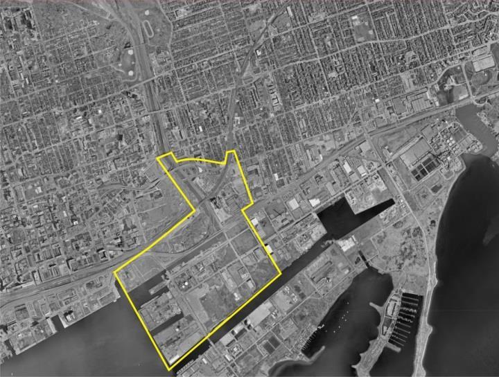
5 Project Location

6 Regulatory Flood Risk Port Lands Flood Plain Flood Protected Flood Protection Landform & Railway Bridge Extension

7 Existing Conditions Don River and Keating Channel provides poor aquatic habitat m 3 of sediment dredged/year 100s of tonnes of floating debris removed/year Contaminated soil and groundwater from past lakefilling & industrial uses Poor to absent terrestrial habitat Mostly derelict industrial lands Lack of infrastructure Very little recreational space Keating Channel Don River Mouth
8 Objectives Based EA Approach Objectives Based EA Evaluations used to : Develop and evaluate alternatives against the project goal and objectives Provide a framework to monitor project performance with goal and objectives Provide consistent measures in the decision-making for project amendments during design and construction to address uncertainty and change Uncertainty and change can relate to planning, engineering, socioeconomic and/or environmental factors (including Climate Change) Adaptive Management was incorporated in the DMNP EA and linked to the project goal and objectives to better respond to uncertainty and change.


9 What is Adaptive Management? A systematic, rigorous approach for deliberately learning from management actions with the intent to improve subsequent management policy or practice Monitor Model Adaptive Management recognizes that: Our understanding of ecosystems is evolving Healthy ecosystems are subject to variability and change Project planning is influenced by changes in political, developmental, socioeconomic, and environmental priorities Learn Adapt Analyze
10 Adaptive Management in the DMNP EA Need to ensure that river functions as designed Ultimately, Adaptive Management has been established to: Ensure that the river functions as intended OR in an unexpected but acceptable manner. Accommodate a range of acceptable functionality Allow for the inclusion of passive and active response mechanisms to allow the river to adapt to future uncertainty that may otherwise precipitate unacceptable functionality


, 2012 DMNP EA Amendment,")


11 Adaptive Management During the DMNP EA Process Central Waterfront Secondary Plan, 2003 Approved EA Terms of Reference, 2006 Lower Don Lands Design Competition, 2007 DMNP EA Conceptual Design, 2010 Port Lands Acceleration Initiative (PLAI), 2012 DMNP EA Amendment, 2013 Informed EA Informed EA Process Process Terms of Reference EA Process EA Submission PLAI EA Paused EA Amendment

12 The Preferred Alternative for the DMNP EA 3 valleys with different functions created through cut and fill Sediment and debris management north of Lake Shore Adaptive weir system at Lake Shore Low flow channel with small protected wetlands within the levees Larger levee separating Ship Channel wetland from Don River
13 Addressing Climate Change in the DMNP EA Early in EA (2003), both MOECC and CEAA directed the Team to consider Climate Change How to incorporate Climate Change was left up to the team. Team first explored How Climate Change could impact the Project: Larger Regulatory Floods Changes in baseflow and the size and frequency flood events (e.g. 2, 10, 25, 50 yr return) Changes in Lake Ontario Water levels (lower, higher?) Connectivity of creative wetlands and ability to respond to changes in baseflows, flood events, and lake levels.
14 Addressing Climate Change in the DMNP EA Challenges with addressing Climate Change: Natural rivers are dynamic and adaptive DMNP project will not respond naturally due to: Hardening of valleys to protect future development, Underlying barriers preventing remaining contaminated soils/groundwater from entering naturalized habitats Need to protect infrastructure and river levees from scour since sediment must be removed upstream of the naturalized areas for navigation and flood protection purposes. Created aquatic habitats, while appearing natural, will not be dynamic and will require passive and active means to respond to Climate Change in their design Quantifying the amount of change to occur is difficult as Climate Change Models were and remain at a coarser resolution than the variables influencing weather and hydrology at the Don Watershed scale.

15 Some of the Features Considered in Conceptual Detail
 Climate Change modeling suggests more frequent and larger hurricanes. To address uncertainty, the Flood Design includes at least an additional 0.")
16 Passive Design Consideration to Address Climate Change Designing for worst-case flood scenario and then some more: Valley design system will convey Regulatory Flood flows which are based on a very conservative design standard (Hurricane Hazel) Climate Change modeling suggests more frequent and larger hurricanes. To address uncertainty, the Flood Design includes at least an additional 0.5m of freeboard (through all three valley sections).

17 Active Design Consideration to Address Climate Change DMNP EA considers active design elements to address changes in size and frequency of floods and variable lake levels Adaptive weir north of Lake Shore proposed to help manage distribution of flood flows between Keating Channel and naturalized valleys to address uncertainty of future Don River hydrology and Lake Ontario water levels resulting from Climate Change


18 Other Passive and Active Design Consideration Used in DMNP EA Multiple Levels of Wetland Resiliency Reduced shear stresses during flood on naturalized habitats with 3 valley configuration. Variable wetland topography and bathymetry allows vegetation communities to respond naturally to changes in long-term changes in Lake water levels. Wetlands protected by water/carp control gates to add resiliency to impacts by unusually high or low lake water levels and carp.


19 Monitoring, Analysis and Adaption is Key TRCA s commitment to monitoring and management is key to the Project: Monitor Model Lake water level and Don Mouth discharge monitoring to inform design and operation of adaptable weir system for existing and future hydrological regime Fish, wildlife and vegetation monitoring to track habitat trajectory and control invasives to ensure acceptable species use is occurring Long-term tracking of changes in local weather due to Climate Change, and the resulting impacts on stream flows, lake levels and local ecology Learn Adapt Analyze
20 QUESTIONS
Welcome to the Boulevard Lake Dam Class Environmental Assessment. Public Information Session #1. June 14, 2016
 Welcome to the Boulevard Lake Dam Class Environmental Assessment Public Information Session #1 June 14, 2016 Boulevard Dam - Overview Built approximately 100 years ago Owned and operated by the City of
ADDRESSING CLIMATE CHANGE ADAPTATION IN EASTERN ONTARIO APRIL 15, 2013
 ADDRESSING CLIMATE CHANGE ADAPTATION IN EASTERN ONTARIO APRIL 15, 2013 IPCC DEFINITION UNFCCC DEFINITION Climate change in Intergovernmental Panel on Climate Change (IPCC) usage refers to a change in the
CALFED Ecosystem Restoration Program (ERP)
") CALFED Ecosystem Restoration Program (ERP) The goal of the Ecosystem Restoration Program is to improve and increase aquatic and terrestrial habitats and improve ecological functions in the Bay-Delta to
CALFED Ecosystem Restoration Program (ERP) The goal of the Ecosystem Restoration Program is to improve and increase aquatic and terrestrial habitats and improve ecological functions in the Bay-Delta to
Lower Don River West. Class Environmental Assessment. Environmental Study Report. Remedial Flood Protection Project
 Class Environmental Assessment Prepared For Toronto and Region Conservation Authority Funded By Toronto Waterfront Revitalization Corporation Government of Canada Province of Ontario City of Toronto In
Advice to decision maker on coal mining project
 . Advice to decision maker on coal mining project IESC 2015-063: West Muswellbrook Project New Development Requesting agency The New South Wales Mining and Petroleum Gateway Panel Date of request 27 January
Click to edit title style
 Click to edit title style Samuel B. Merrill, PhD Judy Gates November 16, 2015 Click to edit Master text styles Second level Third level Fourth level» Fifth level Integrating Storm Surge and Sea Level Rise
Credit Valley Conservation (CVC) Board of Directors. Chief Administrative Officer (CAO) Watershed Knowledge. Watershed Management
 Board of Directors. Chief Administrative Officer (CAO) Watershed Knowledge. Watershed Management") Credit Valley Conservation (CVC) Board of Directors Chief Administrative Officer (CAO) CVC Foundation Human Resources Corporate Watershed Knowledge Watershed Watershed Transformation Planning and Development
Credit Valley Conservation (CVC) Board of Directors Chief Administrative Officer (CAO) CVC Foundation Human Resources Corporate Watershed Knowledge Watershed Watershed Transformation Planning and Development
Flow-ecology relationships. Flow-ecology relationships Susitna case study
 Flow-ecology relationships Flow-ecology relationships Susitna case study Flow regime Ecologically-Relevant Flow Regime Characteristics Seasonal or typical conditions Annual extreme conditions High and
3 Objectives 3 Ob jec tives
 3 Objectives 3 Objectives 3 Objectives 3 Objectives contents Objective number Page 3.1 Ki uta ki tai: mountains to the sea O1-O5 37 3.2 Beneficial use and development O6-O13 38 3.3 Māori relationships
Toronto and Region Conservation 2017 Progress & 2018 Budget Peel Council
 Toronto and Region Conservation 2017 Progress & 2018 Budget Peel Council November 16, 2017 1 2 Input $4,248,000 44 Projects Activities Watershed 2017 Output Increased coverage of Flood Monitoring and Real
Upper Mississippi River Conference 2016 Action Agenda: Raise the Grade
 Upper Mississippi River Conference 2016 Action Agenda: Raise the Grade December 16, 2016 On Oct. 13 14, 2016, a partnership of river stakeholders hosted the ninth annual Upper Mississippi River Conference,
Standards for SWMF s. (Stormwater Management Facilities) Lacombe County s Guide to Developing Stormwater Management Facilities
 Lacombe County s Guide to Developing Stormwater Management Facilities") Standards for SWMF s (Stormwater Management Facilities) Lacombe County s Guide to Developing Stormwater Management Facilities August 2017 PREAMBLE Development results in a great amount of impervious area,
Standards for SWMF s (Stormwater Management Facilities) Lacombe County s Guide to Developing Stormwater Management Facilities August 2017 PREAMBLE Development results in a great amount of impervious area,
Models Quantify the Relationship Between Water Flows/Levels and Ecological Endpoints
 National Conference on Ecosystem Restoration Los Angeles, CA July 20-24, 2009 Models Quantify the Relationship Between Water Flows/Levels and Ecological Endpoints Joseph V. DePinto, Todd M. Redder, Scott
Natural Resources and Climate Resiliency in Germantown
 Natural Resources and Climate Resiliency in Germantown Ingrid Haeckel, Andrew Meyer, and Elizabeth Murphy NYSDEC Hudson River Estuary Program and Cornell University Presentation to the Town of Germantown,
South St. Vrain / Hall Meadows Restoration Planning August 20, 2015
 South St. Vrain / Hall Meadows Restoration Planning August 20, 2015 Agenda Introductions Purpose & Goals of Meeting Planning Area Master Plan Restoration Planning: Cost Estimates, Grants, Scope, Timeline
What Are Environmental (Instream) Flows?
 Flows?") 1 What Are Environmental (Instream) Flows? Sustainable water management requires that both human needs and the needs of aquatic and riparian ecosystems be fulfilled. Dams and diversion of water for municipal
1 What Are Environmental (Instream) Flows? Sustainable water management requires that both human needs and the needs of aquatic and riparian ecosystems be fulfilled. Dams and diversion of water for municipal
Community-Based Watershed Management
 Page 1 of 6 Ohio State University Fact Sheet School of Natural Resources 2021 Coffey Road, Columbus, Ohio 43210 Community-Based Watershed Management WS-0001-00 Joe Bonnell Project Coordinator, Ohio Watershed
Application for resource consent Form B Damming and diversion of water
 Application for resource consent Form B Damming and diversion of water Notes Resource use activities must meet all the conditions of any relevant Permitted Activity Rules in the Waikato Regional Plan or
U.S. Army Corps of Engineers Reservoir Operations Maria Placht, Institute for Water Resources, USACE 49
 U.S. Army Corps of Engineers Reservoir Operations Maria Placht, Institute for Water Resources, USACE 49 Context The U.S. Army Corps of Engineers (the Corps) is responsible for a variety of water resourcerelated
Project Goals and Scoping
 Prepared for: Boulder County, Colorado Flood Planning & Preliminary Design Services for South St. Vrain Creek Restoration at Hall Ranch and Scoping May 24, 2016 Meeting with General Public In association
CHAPTER 7. San Dieguito River Flooding Adaptation
 CHAPTER 7 San Dieguito River Flooding Adaptation This chapter includes a range of adaptation measures to address vulnerabilities from flooding along the San Dieguito River, including the river valley,
ENVIRONMENT ACT TERMS OF REFERENCE NOVA SCOTIA DEPARTMENT OF TRANSPORTATION AND PUBLIC WORKS. Beaver Bank Bypass
 ENVIRONMENT ACT TERMS OF REFERENCE NOVA SCOTIA DEPARTMENT OF TRANSPORTATION AND PUBLIC WORKS Beaver Bank Bypass Highway 101 to the Beaver Bank Road Halifax County, NS NOVA SCOTIA DEPARTMENT OF THE ENVIRONMENT
STREAM AND BUFFER AREA PROTECTION/RESTORATION
 STREAM AND BUFFER AREA PROTECTION/RESTORATION AMENDMENT OPTIONS TO STRENGTHEN POLICY IN HEADWATERS AREAS DRAFT SUBSEQUENT TO THE JANUARY 25, 2007 MEETING OF THE PLANNING COMMISSION ENVIRONMENT COMMITTEE
WATERSHED. Maitland Valley. Report Card 201
 Maitland Valley WATERSHED Report Card 201 The Maitland Valley Conservation Authority has prepared this report card as a summary on the state of our forests, wetlands, surface water, and ground water resources.
Information Requirements Table for Liquid Waste
 Applicant Summary Tracking # Authorization # Applicant / Facility Name Ministry of Environment Prepared by: Title Date The Information Requirements Table (IRT) for Liquid Waste is a tool used by Ministry
AP Environmental Science
 AP Environmental Science Types of aquatic life zones MARINE Estuaries coral reefs mangrove swamps neritic zone pelagic zone FRESHWATER lakes and ponds streams and rivers wetlands Distribution of aquatic
Chapter 4 Watershed Goals and Objectives
 Chapter 4 Watershed Goals and Objectives Eight (8) long-term watershed goals have been developed by the NEW Watershed Advisory Group (WAG) after consideration of discussions held during monthly watershed
The Don River and Central Waterfront are among the most degraded waterways in the City of Toronto.
 This document was put together following the fourth round of public consultation for the Class Environmental Assessment study for this Project. In June 2011, the Project Team consulted with stakeholders
FACTSHEET INTRODUCTION. help rebalance the water cycle, mitigate the effects of climate change and improve human health and livelihoods.
 1 FACTSHEET INTRODUCTION World Water Day, on 22 March every year, is about focusing attention on the importance of water. This year s theme, Nature for Water, explores nature-based solutions (NBS) to the
Environmental impacts of mining. impacts
 Environmental impacts of mining activities and methods to reduce such impacts Bjørn Kløve, Water Resources and Environmental Engineering, Faculty of Technology, CONTENT OF PRESENTATION - Mining pollutant
CE Hydraulics. Andrew Kennedy 168 Fitzpatrick
 CE 40450 Hydraulics Andrew Kennedy 168 Fitzpatrick Andrew.kennedy@nd.edu Hydraulics What does hydraulics mean for engineers and what are typical hydraulic engineering problems? How do these interact with
DECISION MEMO. West Fork Blacktail Deer Creek Hardened Crossing
 Page 1 of 6 Background DECISION MEMO USDA Forest Service Madison Ranger District Madison County T12S, R4W, Section 30 The project is in the Gravelly Landscape, Snowcrest Recommended Wilderness Management
Water Balance Component of TRCA s Watershed Planning Studies
 Water Balance Component of TRCA s Watershed Planning Studies Glenn Farmer and Sonya Meek, TRCA CMHC On-line Teleconference September 22, 2005 REVIEW and EVALUATE MONITOR and REPORT PLAN WATERSHED PLANNING
Lesson 2-2: Riparian Zones
 2-14 Lesson 2-2: Riparian Zones Time of Lesson: 1 hour Rationale: The purpose of this lesson is to define what a riparian zone is and link its importance for fish and other animals, and humans, and the
Environment & Conservation Introduction
 Environment & Conservation Introduction Anacortes is blessed with an abundance of natural beauty. Residents identify marine shorelines, streams, lakes, forested areas, and other natural features as defining
The Next Generation of Mitigation: Linking Current and Future Mitigation Programs with State Wildlife Action Plans and Other State and Regional Plans
 : Linking Current and Future Mitigation Programs with State Wildlife Action Plans and Other State and Regional Plans August 4, 2009 Jessica B. Wilkinson, James M. McElfish, Jr., and Rebecca Kihslinger
Will be modified map from GIS 6/16 EOD
 Middle-Snake-Tamarac Rivers Watershed District Judicial Ditch #19 Watershed Regional Conservation Partnership Program (RCPP) Public Scoping Meeting September 26, 2016 Will be modified map from GIS 6/16
Comprehensive Study Scoping Document. for Lower Mattagami Hydroelectric Complex Redevelopment CEAR Reference Number:
 Comprehensive Study Scoping Document for Lower Mattagami Hydroelectric Complex Redevelopment CEAR Reference Number: 07-03-26302 Prepared pursuant to Subsection 21(1) of the Canadian Environmental Assessment
Climate: describes the average condition, including temperature and precipitation, over long periods in a given area
 Ch. 6 - Biomes Section 6.1: Defining Biomes Biome: a group of ecosystems that share similar biotic and abiotic conditions, large region characterized by a specific type of climate, plants, and animals
Municipal Class Environmental Assessment for Pottersburg Creek Slope Stability Study South of Hamilton Road, Schedule B
 Municipal Class Environmental Assessment for Pottersburg Creek Slope Stability Study South of Hamilton Road, Schedule B February 13, 2013 Municipal Class EA Process We are here Purpose and Objective of
OIL SPILL COOPERATIVE Member Newsletter
 Member Newsletter JULY 2013 VOLUME 2 ISSUE 7 IN THIS ISSUE Year in Review: 2016 Spills World Class or World Leading? Coop Exercises 2016 Low-impact Spill Response WCSS Oil Spill Contingency Phone App Open
2017 Central Valley Flood Protection Plan Update: Overview
 2017 Central Valley Flood Protection Plan Update: Overview 2015 FMA Conference CVFPP Overview- Mike Mierzwa, DWR Basin-wide Feasibility Study Planning Context- Eric Tsai, DWR Technical Tools/Methodologies-
GUIDE TO THE DEVELOPMENT OF A MINING AND RECLAMATION PLAN IN NEW BRUNSWICK
 PROVINCE OF NEW BRUNSWICK DEPARTMENT OF ENERGY AND RESOURCE DEVELOPMENT Minerals and Petroleum Development Branch GUIDE TO THE DEVELOPMENT OF A MINING AND RECLAMATION PLAN IN NEW BRUNSWICK Guide to the
Dam Decommissioning and Removal
 Dam Decommissioning and Removal Technical Bulletin Ontario Ministry of Natural Resources This publication is available online at: Ontario.ca/dams Ces documents sont offerts en anglais seulement en raison
February Reference Section in Supplemental. Reference Section in Consultants Reports. Reference Section in Application. TOR No.
 Request i Final Terms of Environmental Impact Assessment Report for Coal Valley Resources Inc. (CVRI) Proposed Robb Trend Project Cross (Concordance) Table to Location in ii PURPOSE OF THE TERMS OF REFERENCE
EFFECT OF UPSTREAM DEVELOPMENT ON THE CLEAR CREEK AREA
 EFFECT OF UPSTREAM DEVELOPMENT ON THE CLEAR CREEK AREA Technical Memorandum Farming in the Floodplain Project Prepared for May 2017 PCC Farmland Trust Photo credit: Google Earth TABLE OF CONTENTS Page
Hello my name is Joy Loughry and I am with the groundwater technical unit of the Minnesota department of natural resources. Today I am going to talk
 Hello my name is Joy Loughry and I am with the groundwater technical unit of the Minnesota department of natural resources. Today I am going to talk about how the state of Minnesota manages its Water resources
Where Funds are Spent
 Page 1 of 10 DNR FY 2014-15 Budget 2013 Legislative Session Where Funds are Spent The DNR is organized into seven operating divisions, or programs, for managing where funds are spent. The Divisions are
BENEFITS OF TRANSBOUNDARY COOPERATION IN GEORGIA AND AZERBAIJAN - KURA RIVER BASIN
 BENEFITS OF TRANSBOUNDARY COOPERATION IN GEORGIA AND AZERBAIJAN - KURA RIVER BASIN Initial inventory of the potential benefits of cooperative water management Tatiana Efimova, OECD 24 October 2013, Helsinki
A State Policy Framework for Adaptation to Climate Change
 A State Policy Framework for Adaptation to Climate Change James Murley, Director Barry N. Heimlich Nick Bollman* Center for Urban and Environmental Solutions at Florida Atlantic University *In Memoriam
CLIMATE CHANGE AND WATER MANAGEMENT: FEAR OF UNCERTAINTY
 CLIMATE CHANGE AND WATER MANAGEMENT: FEAR OF UNCERTAINTY GRETCHEN GREENE, PH.D. ENVIRONMENTAL ECONOMIST, RAMBOLL ENVIRON US 2015 AWRA WASHINGTON STATE CONFERENCE WATER MANAGEMENT STRATEGIES IN THE FACE
Towards Collaborative Adaptive Approach to Watershed Management
 Towards Collaborative Adaptive Approach to Watershed Management An update on progress towards a new way of doing SMART business Les Stanfield Ontario Ministry of Natural Resources November 22, 2012 Outline
Rivermouth classification as a tool for guiding restoration
 Rivermouth classification as a tool for guiding restoration JEFF SCHAEFFER 1, J. C. NELSON 2, AND JAMES H LARSON 2, 1 USGS Great Lakes Science Center 2 USGS Upper Midwest Environmental Sciences Center
June 22, Francis E. Borcalli, P.E.
 CACHE CREEK SETTLING BASIN SYMPOSIUM Managing the Settling Basin Who s Doing What! June 22, 2009 Francis E. Borcalli, P.E. CACHE CREEK SETTLING BASIN SYMPOSIUM Managing the Settling Basin Who s Doing What!
Climate Change: Impacts, Monitoring, and Solutions
 Climate Change: Impacts, Monitoring, and Solutions 1 Responding to Climate Change 1. Projections/Impacts 2. Adaptation and Resiliency 3. Monitoring 4. What about emissions? 2 Native trout and salmon are
Removal of a Portion of Lower Don Special Policy Area - Official Plan Amendment - Directions Report
 STAFF REPORT ACTION REQUIRED Removal of a Portion of Lower Don Special Policy Area - Official Plan Amendment - Directions Report Date: May 18, 2012 To: From: Wards: Reference Number: Toronto and East York
AP Environmental Science
 2017 AP Environmental Science Sample Student Responses and Scoring Commentary Inside: RR Free Response Question 4 RR Scoring Guideline RR Student Samples RR Scoring Commentary 2017 The College Board. College
Sovereign Lands and Great Salt Lake
 Sovereign Lands and Great Salt Lake The Living Lake - Charles Uibel Laura Ault Sovereign Lands Program Manager Division of Forestry, Fire and State Lands What are Sovereign Lands? Lakebeds and riverbeds
Information Request 37
 Information Request 37 Information Request 37 37-1 Response to Information Request 37 Response to Information Requests 37a Response to Information Requests 37b 37-3 37-5 Federal Review Panel Information
Final Environmental Assessment Guidelines (including the Scope of the Environmental Assessment)
") Final Environmental Assessment Guidelines (including the Scope of the Environmental Assessment) July 2012 RDIMS: 7401089 Page left intentionally blank I RDIMS: 7401089 II RDIMS: 7401089 Page left intentionally
Final Environmental Assessment Guidelines (including the Scope of the Environmental Assessment) July 2012 RDIMS: 7401089 Page left intentionally blank I RDIMS: 7401089 II RDIMS: 7401089 Page left intentionally
Yes: Y No: N (a) (b) (c) (d) (a) (a) (b) (c) (d) (e)
 (b) (c) (d) (a) (a) (b) (c) (d) (e)") Checklist: 3. Hydropower Stations, Dams and Reservoirs (1) 1 Permits and Explanation 2 Pollution Control (1) EIA and Permits (2) Explanation to the Local Stakeholders Main Check s Have EIA reports been
Checklist: 3. Hydropower Stations, Dams and Reservoirs (1) 1 Permits and Explanation 2 Pollution Control (1) EIA and Permits (2) Explanation to the Local Stakeholders Main Check s Have EIA reports been
Understanding the State Planning Policy July 2017 Changes to state interest statements, policies and assessment benchmarks
 Understanding the State Planning Policy July 2017 Changes to state statements, policies and assessment benchmarks This fact sheet outlines the key policy changes to the state statements, policies and assessment
CHAPTER 3 Environmental Guidelines for WATERCOURSE CROSSINGS GOVERNMENT OF NEWFOUNDLAND AND LABRADOR DEPARTMENT OF ENVIRONMENT AND LABOUR
 GOVERNMENT OF NEWFOUNDLAND AND LABRADOR DEPARTMENT OF ENVIRONMENT AND LABOUR CHAPTER 3 Environmental Guidelines for WATERCOURSE CROSSINGS WATER RESOURCES MANAGEMENT DIVISION Water Investigations Section
WELCOME! Mill Creek Daylighting Technical Feasibility Study. Thank you! Open House December Please sign in and get a comment form.
 WELCOME! Daylighting Technical Feasibility Study Open House December 2016 Please sign in and get a comment form. Thank you! WHAT IS DAYLIGHTING? Daylighting refers to the process of re-establishing creeks
Climate Vulnerability Assessment: Wild Rice. Wild rice, known as Manoomin by the Ojibwe of northern Wisconsin, is a cultural
 Hansen 1 Hans Hansen ES 600 Conaway, Hitch Capstone Paper Draft 13 April 2015 Climate Vulnerability Assessment: Wild Rice Introduction Wild rice, known as Manoomin by the Ojibwe of northern Wisconsin,
Science Plan. Executive Summary. Introduction
 Science Plan Executive Summary This Science Plan will establish and define the focus of the Peninsular Florida Landscape Conservation Cooperative (PFLCC) science investments. The data and products derived
Criteria for Identifying and Prioritizing Habitat Protection and Restoration Projects on the Lower Columbia River and Estuary*
 Criteria for Identifying and Prioritizing Habitat Protection and Restoration Projects on the Lower Columbia River and Estuary* Ecosystem Criteria 1) Habitat Connectivity (0-10 points) This criterion recognizes
Riparian Buffers and Stream Restoration
 Riparian Buffers and Stream Restoration Why focus on riparian areas? Link land and water on any given site and link landscapes together in a watershed Riparian corridors protect the circulatory system
Port Lands Flood Protection and Enabling Infrastructure Due Diligence Report
 &9"UUBDINFOU 1-Part 1 Port Lands Flood Protection and Enabling Infrastructure Due Diligence Report Toronto, Ontario October 20, 2016 Prepared by: Waterfront Toronto 20 Bay Street, Suite 1310 Toronto, Ontario
Constructed Wetland Channel T-9
 Description A constructed wetland channel is a conveyance BMP that is built, in part, to enhance stormwater quality. Constructed wetland channels use dense vegetation to slow down runoff and allow time
Joint Public Notice. LOCATION: In Salmon Bay, Lake Washington Ship Canal, at Seattle, Washington.
 US Army Corps of Engineers Seattle District Joint Public Notice Application for a Department of the Army Permit and a Washington Department of Ecology Water Quality Certification and/or Coastal Zone Management
Friends of Owhiro Stream Wellington, New Zealand
 Friends of Owhiro Stream Wellington, New Zealand First name(s) Last name Street address Mr Martin Payne I am writing this submission on behalf of an organisation Friends of Owhiro Stream Type of organisation:
POLICY FOR NATURAL RESOURCE MANAGEMENT AREAS
 POLICY FOR NATURAL RESOURCE MANAGEMENT AREAS I. POLICY STATEMENT Auburn University's (the University's) "Policy for Natural Resource Management Areas" implements the Campus Master Plan Land Use Element
Initial Application of a Landscape Evolution Model to a Louisiana Wetland
 Initial Application of a Landscape Evolution Model to a Louisiana Wetland by Carl F. Cerco PURPOSE: Corps planning projects encompass a wide variety of restoration goals. These include wetland restoration,
 Good Morning! Bruce Gilman Department of Environmental Conservation and Horticulture Finger Lakes Community College 3325 Marvin Sands Drive Canandaigua, New York 14424 585-785- 1255 gilmanba@flcc.edu Northern
(1) Bridge, Road and Railway (Adaptation Project) (2) Bridge, Road and Railway (BAU Development with Adaptation Options)
 Bridge, Road and Railway (Adaptation Project) (2) Bridge, Road and Railway (BAU Development with Adaptation Options)") Sub-sector Guideline: (1) Bridge, Road and Railway (Adaptation Project) (2) Bridge, Road and Railway (BAU Development with Adaptation Options) Basic Concept A. General Concept Climate change will increase
Sub-sector Guideline: (1) Bridge, Road and Railway (Adaptation Project) (2) Bridge, Road and Railway (BAU Development with Adaptation Options) Basic Concept A. General Concept Climate change will increase
G.B. Sonny Hall, PhD. Veronika Thiebach
 G.B. Sonny Hall, PhD Technical Program Manager Veronika Thiebach Senior Assistant General Counsel St. Johns River Water Management District 1 SJRWMD MFLs Method MFLs Method Premises Case studies Lake Hiawassee
Municipal Stadium Wetland
 W A T E R S H E D F A C T S Total watershed area 140 mi 2 Average annual rainfall 38 in Average annual temperature 58 F Elevation Max 1321 ft Min 899 ft C. J. Brown Reservoir controls flow from 83 mi 2
Humber River Watershed Scenario Modelling and Analysis Report. Chapter 3.0 Integrated Study Design
 Humber River Watershed Scenario Modelling and Analysis Report Chapter 3.0 Integrated Study Design TABLE OF CONTENTS 3.0 INTEGRATED STUDY DESIGN... 3-1 3.1 Study questions... 3-1 3.2 Land Use and Management
The Importance of the Pearl River to Mississippi s Estuarine Habitats Jennifer Buchanan Education Coordinator
 The Importance of the Pearl River to Mississippi s Estuarine Habitats Jennifer Buchanan Education Coordinator 2006 Pearl River Basin Symposium May 5-6, 2006 Topics for Discussion What s an estuary? Pearl
Tools Quantifying the Benefits and Life Cycle Costs of Green Infrastructure Sakshi Saini
 Tools Quantifying the Benefits and Life Cycle Costs of Green Infrastructure Sakshi Saini Latornell Conference November 17, 2016 Outline Background Tools: 1. Low Impact Development Treatment Train Tool
3-13 Other Required Findings and Regulatory Compliance
 Affected Environment and Environmental Consequences 3-13 Other Required Findings and Regulatory Compliance 3-13.1 Short-term Uses and Long-term Productivity NEPA requires consideration of the relationship
MARINE POLLUTION DEGRADATION MITIGATION MANAGEMENT IS ESSENTIAL FOR IMPROVING MARINE ENVIRONMENT
 MARINE POLLUTION DEGRADATION MITIGATION MANAGEMENT IS ESSENTIAL FOR IMPROVING MARINE ENVIRONMENT The health of the world s oceans and marine life is degrading rapidly as a result of excess human activities.
MONDAY, 27 FEBRUARY 2017
 MONDAY, 27 FEBRUARY 2017 Room 301 B 302 A/B 304 A/B 305 A/B 306 A 306 B 308 A/B 199 168 258 162 150 168 194 9:00-9:50 9:50 - MORNING PLENARY - Marcia McNutt - 9:00 to 9:50 Session# 71 96 12 9 34 58 65
Why Do We Need Market Based Instruments to Conserve and Manage Alberta s Riparian Lands?
 Why Do We Need Market Based Instruments to Conserve and Manage Alberta s Riparian Lands? Judy Stewart, LL.M. Bow River Basin Council Workshop March 23, 2012 Outline What are riparian lands? Conserving
Adapting to climate change in nature conservation in Europe
 Adapting to climate change in nature conservation in Europe Aletta Bonn & Nicholas Macgregor Freie Universität Berlin, Institut für Biologie, Berlin-Brandenburg Institute of Advanced Biodiversity Research
Aquatic Fish and Wildlife Habitat Management
 Aquatic Fish and Wildlife Habitat Management Tier 2 Worksheet Community Environmental Management 303 Acknowledgements The New York State Soil and Water Conservation Committee and Department of Environmental
Green River Diversion Rehabilitation
 USDA Natural Resources Conservation Service-Utah Wallace F. Bennett Federal Building 125 S. State Street Room 4010 Salt Lake City, UT 84138-1100 Green River Diversion Rehabilitation National Environmental
Marysville Levee Commission
 Marysville Levee Commission Outline CVFPP Goals & Objectives Highlights of Draft Feather River RFMP Integration between Flood Protection, Agriculture and Wildlife and Floodplain Uses Proposed Projects
Beds of Water Bodies 14 September 2017
 Beds of Water Bodies 14 September 2017 Contents Beds of Water Bodies... 1 Activities in the Beds of Water Bodies Issues... 1 Objectives... 4 Policies... 4 Methods of Implementation... 7 Rules... 11 Stock
Marine Board Spring Meeting April 27, 2011 David M. Kennedy
 Marine Board Spring Meeting April 27, 2011 David M. Kennedy NOS Organization 2 NOAA Next Generation Strategic Plan National Ocean Policy and Coastal Goal NOAA s Coastal Goal Objectives Resilient coastal
Removal of a Portion of Lower Don Special Policy Area Official Plan Amendment Final Report
 STAFF REPORT ACTION REQUIRED Removal of a Portion of Lower Don Special Policy Area Official Plan Amendment Final Report Date: September 20, 2012 To: From: Wards: Reference Number: Toronto and East York
Ontario Envirothon LEARNING OBJECTIVES. Ontario Envirothon Learning Objectives
 Ontario Envirothon LEARNING OBJECTIVES Updated Fall 2015 5 Contents Contents... 6 Overall Objectives... 7 Aquatic Ecology... 8 Specific Objectives... 8 Overall Objectives... 8 Application/Analysis... 9
Hydrologic and Ecologic Impacts from the CERP Indian River Lagoon South Project
 Hydrologic and Ecologic Impacts from the CERP Indian River Lagoon South Project Dr. Gretchen Ehlinger Senior Biologist US Army Corps of Engineers Jacksonville District November 15, 2016 AWRA Conference
Scenario Narratives Case Study: KBNERR
 Scenario Narratives Case Study: KBNERR Each of the following 4 scenario narratives was developed through one on one informational interviews with local leaders and researchers through the KBNERR Coastal
New Castle County, DE. Floodplain Regulations
 New Castle County, DE Floodplain Regulations John J. Gysling, PE CFM Department of Land Use New Castle County, DE February 26, 2009 Today s Presentation Floodplain Protection and Uses Terms and Definitions
Snapshots. Photo Credit: crabchick. Photo Credit: Kyoww. Photo Credit: Sharada Prasad CS. Photo Credit: Sharada Prasad CS
 Snapshots Lake Baikal Lake Baikal is home to more than 2,000 species, many of which exist nowhere else on the planet. It is the most biodiverse lake on earth. Included in this assemblage are several hundred