Natural Environment Existing Conditions Terrestrial
|
|
|
- Debra Glenn
- 6 years ago
- Views:
Transcription

.")

 adjacent to the Southeast and")
1 Natural Environment Existing Conditions Terrestrial Alternative 1 Significant Woodland in the Southeast and Southwest Woodlots. Significant Wildlife Habitat (SWH) in the Southeast and Southwest Woodlots (habitat for provincially rare Giant Swallowtail butterfly). Deciduous swamp (part of a Locally Significant Wetland in the Southeast Woodlot). One significant amphibian breeding site in the Southeast Woodlot. Three other minor amphibian breeding sites which do not qualify as SWH. Cultural Woodland (less functional vegetation) adjacent to the Southeast and Southwest Woodlots. One Butternut tree, which is identified as an Endangered Species.

 in the")
.")


2 Natural Environment Existing Conditions Terrestrial Alternative 2 Significant Woodland in the Southwest and South Woodlots. Significant Wildlife Habitat (SWH) in the Southwest and South Woodlots (habitat for provincially rare Giant Swallowtail butterfly). One significant amphibian breeding site in the Southeast Woodlot. Two other minor amphibian breeding sites which do not qualify as SWH. Cultural Woodland (less functional vegetation) adjacent to the Southwest Woodlot.


3 Natural Environment Existing Conditions Aquatic A limited isolated off-line residence of a small baitfish community exists within the Equalization Reservoir. A permanent barrier to fish passage exists at the point of discharge from the Equalization Reservoir to the off-site receivers. As surface waters are ultimately discharged off-site, the receiving waters and watercourses were the primary focus of study as it relates to aquatic ecosystems. Fish habitat from monitored stations within the Alternative 1 and Alternative 2 Study Area was found to be of uniform morphology and sensitivity. Fish community is composed of generalist species that are wide spread in distribution and not particularly sensitive to environmental change. No records of aquatic Species at Risk (SAR) were identified (as referenced by the Committee on the Status of Species at Risk in Ontario (COSSARO) and the Committee on the Status of Endangered Wildlife in Canada (COSEWIC)).
4 Natural Environment Net Effects Analysis and Comparative Evaluation The Net Effects and Comparative Evaluation for the Natural Environment were conducted using the following criteria and indicators: Criteria Terrestrial Ecosystems Aquatic Ecosystems Indicators Predicted impact on vegetation communities due to landfill footprint, construction and operations onsite. Predicted impact on Wildlife Habitats due to landfill footprint, construction and operations on-site. Predicted impact on amphibian habitat and communities due to landfill footprint, construction and operations. Presence of known or identified Species at Risk and their habitats and the predicted impact of the proposed footprint, construction and operations. Predicted impact on aquatic habitat due to landfill footprint, construction and operations on-site. Predicted impact on fisheries due to construction and operations on-site. Presence of known or identified Species at Risk and their habitats and the predicted impact of the proposed footprint, construction and operation onsite.


5 Natural Environment Net Effects Analysis and Comparative Evaluation Summary of the Terrestrial Net Effects Analysis: Alternative 1: Alternative 2: With compensation plantings, no net loss of significant vegetation communities anticipated; however, there will be a longer term loss of mature swamp and mature forest as these areas will take many decades to mature. Net loss of 0.77 ha of other, less significant vegetation from the Southwest Woodlot; however, effects are considered minor due to the lower quality of the vegetation. No net loss of SWH or amphibian breeding locations. New forest edge will grow in naturally after several years minimizing the edge effects. Wildlife avoidance along forest edge of Southeast Woodlot. No net effects on Butternuts anticipated with the compensation planting and the survival of the seedlings. With compensation plantings, no net loss of significant vegetation communities anticipated; however, there will be a longer term loss of mature forest as these areas will take many decades to mature. Net loss of 1.97 ha of other, less significant vegetation; however, effects are considered minor due to the lower quality of the vegetation. No net loss of SWH or amphibian breeding locations. New forest edge will grow in naturally after several years minimizing the edge effects. Wildlife avoidance along forest edge of South Woodlot and the Southwest Woodlot. Barriers in wildlife movement due to chain-link fence.
6 Natural Environment Net Effects Analysis and Comparative Evaluation Summary of the Aquatic Net Effects Analysis: Aquatic ecosystems are anticipated to be primarily influenced under either Alternative design by changes in sedimentation, changes in flow regime and changes in surface water quality. Changes in sedimentation and changes in flow are anticipated to be controlled or mitigated through the operation of the Surface Water Treatment Plant. Surface water quality conditions contribute to the overall suitability of fish habitat for fish use. Based on the findings of the hydrogeology & geology and surface water net effects analysis and comparative evaluation reports, the following net effects to surface water quality are anticipated. Alternative 1: Alternative 2: Maximum mass discharge of chloride (used as a surrogate parameter for assessing relative impact) from groundwater to surface water is expected to decline in comparison to anticipated loadings under future baseline conditions which will result in no net effects to fish within the Equalization Reservoir and/or to fish or fish habitat off-site within the downstream receivers. Maximum mass discharge of chloride from groundwater to surface water is expected to increase significantly in comparison to anticipated loadings under future baseline conditions which likely impact the suitability of fish habitat for fish use off-site within the downstream receivers. Summary of the Comparative Evaluation of the Natural Environment: Alternative 2 is slightly preferred from a terrestrial ecosystem perspective due to a lesser amount of significant forest vegetation removal and no net effects on Species at Risk. Alternative 1 is preferred from an aquatic ecosystems perspective due to the overall smaller waste footprint, one point discharge for off-site drainage and lesser potential for flooding implications and the lower projected mass discharge of chloride from groundwater to surface water. Overall, Alternative 1 is preferred in terms of effects on the natural environment.
7 Air Quality and Odour Existing Conditions Air dispersion modelling results indicate that there are no exceedances of any air quality standards due to the Facility's air emissions. o This has been confirmed by the Facility's annual fenceline monitoring program. The primary Facility odour sources are the: o Landfill leachate ponds; o Carbon pre-treatment area; o Landfill working face; and o Thermal desorption units. Clean Harbors implemented a Fugitive Dust and Odour Best Management Plan that has reduced the potential for odour impacts. o Recent odour monitoring programs have indicated that there are no off-site odour impacts from the main potential odour sources.
 of indicator compounds.")
8 Air Quality and Odour Net Effects Analysis and Comparative Evaluation The Net Effects and Comparative Evaluation for Air Quality and Odour were conducted using the following criteria and indicators: Criteria Air Emissions Indicators Predicted off-site point of impingement concentrations (g/m 3 ) of indicator compounds. Number of off-site receptors potentially affected (residential properties, public facilities, businesses/farms, institutions). Odour Predicted off-site odour concentrations (g/m 3 and odour units). Number of off-site receptors potentially affected (residential properties, public facilities, businesses/farms, institutions). Covered Leachate Ponds
9 Air Quality and Odour Net Effects Analysis and Comparative Evaluation Summary of the Net Effects Analysis: Alternative 1: Alternative 1 has slightly higher potential off-site point of impingement (POI) concentrations than Alternative 2; however, the difference is not considered substantial. o All potential off-site air quality impacts from the Facility comply with the MOE health and risk based Air Quality Standards. The total number of receptors potentially affected by off-site POI concentrations is the same for each Alternative. o Receptors closest to the proposed landfill are already in the vicinity of the existing landfill and the net change in effects is not considered significant. Under normal operations, there are no off-site odour impacts from the Facility; however, under an upset scenario, potential off-site odour concentrations would be the same for either Alternative. Alternative 2: All potential off-site air quality impacts from the Facility comply with the MOE health and risk based Air Quality Standards. Receptors closest to the proposed landfill are not currently in the vicinity of the existing landfill, and the net change in effects at these receptors is more significant than the net change for Alternative 1. Summary of the Comparative Analysis: Potential fugitive dust emissions from the short-term construction activities for each Alternative were considered to provide further insight into which Alternative is preferred. o Alternative 2 would require further mitigation measures than Alternative 1; therefore, when considering short-term construction activities, Alternative 1 is the preferred Alternative. Alternative 2 presents a greater risk of an upset scenario regarding odour concentrations related to the leachate. Overall, Alternative 1 is preferred as it would have lower construction effects and a lower risk of an upset scenario regarding odour concentrations.
10 Air Quality and Odour Net Effects Analysis and Comparative Evaluation Alternative1 Alternative2 PeopleandTechnologyCreatingaBetterEnvironment

 or sensitive receptors (schools or places of worship).")
11 Noise Existing Conditions Existing noise levels at the Facility meet the Ministry of the Environment (MOE) noise limits, 40 dba to 55 dba, at the 14 surrounding residential point-of-reception. MOE defines a "point-of-reception" as permanent or seasonal residences for overnight accommodation (homes, hotels/motels, nursing/retirement homes, rental residences, hospitals and overnight campgrounds) or sensitive receptors (schools or places of worship). Noise existing conditions for the Study Area are summarized as follows: o Steady state noise from the existing Facility; o Impulse noise generated from the baghouse controls; and o Road traffic noise from Petrolia Line, Brigden Road, Plank Road, Rokeby Line.
12 Noise Net Effects Analysis and Comparative Evaluation The Net Effects and Comparative Evaluation for Noise were conducted using the following criteria and indicators: Criteria Noise Emissions Indicators Predicted off-site noise level. Number of off-site receptors potentially affected including residential properties, public facilities, businesses, farms and institutions. Summary of the Net Effects Analysis: Alternative 1: All receptors will remain below the MOE noise limits for landfill operations. The off-site environmental noise impact is limited to the 8 residents to the north. The most affected receptor will experience a net increase of 1 dba which is considered acoustically insignificant. Alternative 2: All receptors will remain below the MOE noise limits for landfill operations. The 5 residents to the south of the Study Area will experience a noise increase of more than 10 dba. A greater than 10 dba change in sound is perceived as twice as loud. Summary of the Comparative Evaluation: Alternative 1 is preferred as it provides the lowest noise impact exposure for the majority of the off-site receptors.
13 Noise Net Effects Analysis and Comparative Evaluation Alternative1 Alternative2 PeopleandTechnologyCreatingaBetterEnvironment
.")
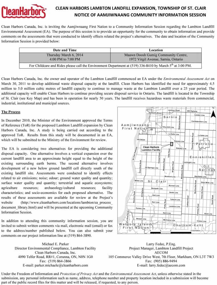
14 Socio-Economic Existing Conditions In 2011, St. Clair Township s population was approximately 14,515. There are 69 residences within 1,500 m of Alternative 1 and 2 (see Figure for boundaries). One commercial business was identified within this area (excluding agricultural operations). Clean Harbors makes financial contributions to neighboring property owners through its Good Neighbours Program. Clean Harbors also makes financial contributions to St. Clair Township through taxes and service fees, including an annual waste volume fee. The area around the Facility is a quiet, agricultural community dominated by flat open farmland. The existing Lambton Facility is largely screened from the surrounding area; however, some elements of the Facility are visible such as the incinerator stack.
15 Socio-Economic Net Effects Analysis and Comparative Evaluation The Net Effects and Comparative Evaluation for the Socio-Economic Environment were conducted using the following criteria and indicators: Criteria Economic Social Indicators Opportunities to provide goods or services. Change in municipal tax base resulting from change in land use. The relative number and levels of jobs at the facility, in the community and among suppliers that are created/sustained during construction and operations. The relative dollar values of construction and operations of the project in terms of contribution to the local economy. Displacement of business activities. Effects on Municipal revenues (e.g., fees, service charges) and expenditures (e.g., costs associated with providing services to the site and other responsibilities such as participating in monitoring activities). Existing off-site businesses and numbers of employees within 500, 1,000 and 1,500 m of the landfill site boundary. Presence of known or identified Petroleum Resources or related abandoned infrastructure/wells and the predicted impact of the proposed footprint, construction and operation on-site. Presence of known or identified Aggregate Resources and the predicted impact or impairment of their use due to the proposed footprint, construction and operation on-site. Nuisances caused by weeds due to exposed site area and berms. Existing off-site residents within 500 m of the landfill boundary. Existing off-site residents within 1,000 m of the landfill boundary. Existing off-site residents within 1,500 m of the landfill boundary. Predicted changes in landscapes and views.
16 Socio-Economic Net Effects Analysis and Comparative Evaluation Summary of the Net Effects Analysis: Alternative 1: Economic: No net effects on the municipal tax base, displacement of business activities, municipal revenues, businesses and employees within the Study Area, petroleum resources or aggregate resources. Some positive net effects on opportunities to provide goods and services, the number and levels of jobs in the community and the dollar value of construction and operation activities. Social: No effects on the use and enjoyment of residences within 1,500 m are anticipated; however, there will be a few locations where the landfill will be visible from off-site due to the lower berm elevation in the vicinity of the site entrances. Alternative 2: Economic: No net effects on the displacement of business activities, municipal revenues, businesses and employees within the Study Area, petroleum resources or aggregate resources. Some positive net effects on the opportunities to provide goods and services, changes in the municipal tax base, the number and levels of jobs in the community, the dollar value of construction and operation activities and municipal revenues. Social: Negative effects identified for all social criteria indicators off-site residences within 500, 1,000 and 1,500 m and predicted changes in landscape and views. Summary of the Comparative Evaluation: Alternative 2 is anticipated to generate slightly more property tax revenue for the Municipality than Alternative 1. For this reason, Alternative 2 is preferred over Alternative 1 with regard to the Economic indicators, although the difference is considered relatively minor. Given that Alternative 1 is preferred in terms of all social indicators and the difference in economic indicators is minor, overall, Alternative 1 is preferred.

17 Agriculture Existing Conditions An assessment of soils and Canada Land Inventory ratings indicate that the Study Area is comprised of Prime Agricultural Lands (Class 2 and 3 lands). Predominant agricultural use in the Study Area is associated with cash crops; including: o Corn; o Soybean; o Pasture; and o Small grains. Majority of the Study Area contains artificial tile drainage, these lands with tile drainage confirm that there is investment related to agriculture.
18 Agriculture Net Effects Analysis and Comparative Evaluation The Net Effects and Comparative Evaluation for Agricultural Resources were conducted using the following criteria and indicators: Criteria Agriculture Resources Indicators Displacement of high quality agricultural lands. Agriculture operational impacts. Particulate (dust) emissions from landfill. Nuisances caused by weeds due to exposed site area and berms. Summary of the Net Effects Analysis: Alternative 1: May require a shift in the southern property boundary by 153 m to be consistent with the buffer requirements of the existing zoning by-law. Results in the displacement of 1.9 ha of Class 2 lands, 9.7 ha of Class 3 lands and the loss of 2.2 ha of Disturbed Lands. Alternative 2: Results in the displacement of 45.0 ha of Class 2 lands, 73.8 ha of Class 3 lands which represent approximately 97.1 % of the Alternative 2 Study Area (the remaining 2.9% comprises Disturbed Lands). Summary of the Comparative Evaluation: Alternative 1 and Alternative 2 would have no substantial difference with respect to agricultural operation impacts (i.e. particulate emissions from the landfill and nuisances caused by weeds due to the exposed site area and berms). Alternative 1 is preferred as it would displace less high quality agricultural lands and there is no substantial difference for agricultural operational impacts.

19 Archaeology and Cultural Heritage Existing Conditions The Stage 1 archaeological assessment determined that no archaeological sites have been registered within 2 km of the Study Area. A review of the general physiography of the Study Area suggested that it has low potential for the identification of Aboriginal archaeological sites. However, local 19th century land use suggested that the Study Area has potential for the identification of Euro-Canadian archaeological sites. A Stage 2 Archaeological Assessment must be conducted on all land which may be disturbed from proposed construction and operation activities to confirm potential impacts to archaeological resources prior to any land disturbance, in accordance with MTCS 2011 Standards and Guidelines for Consultant Archaeologists. Alternatives 1 and 2 contain two cultural heritage resources, the pioneer cemetery and Telfer Road cultural heritage landscape, respectively.
20 Archaeology and Cultural Heritage Net Effects Analysis and Comparative Evaluation The Net Effects and Comparative Evaluation for the Archaeology and Cultural Heritage were conducted using the following criteria and indicators: Criteria Archaeological Resources Above Ground Cultural Heritage Resources Indicators Presence of known archaeological resources. Potential effects on archaeological potential. Presence of built heritage resources or cultural heritage landscapes. Presence of designated (Ontario Heritage Act), commemorated (National Historic Site or historical plaque) inventoried (listed on a municipal heritage register), and identified built heritage resources and cultural heritage landscapes in the site vicinity. Potential effects on above ground cultural heritage resources. Effects can include direct and indirect impacts. Direct impacts can include displacement through removal, while indirect impacts can include disturbance through the introduction of visual, audible, or atmospheric elements not in keeping with the surrounding setting.
21 Archaeology and Cultural Heritage Net Effects Analysis and Comparative Evaluation Summary of the Net Effects Analysis: Alternative 1: No known archaeological resources are present in the Alternative 1 Study Area. Potential net effects on areas with archaeological potential will be avoided or mitigated through conducting a Stage 2 Archaeological Assessment. No net effects on cultural heritage resources anticipated as the existing entrance to the site will continue to be used thus avoiding the identified cultural heritage resources. Alternative 2: No known archaeological resources are present in the Alternative 2 Study Area. Potential net effects on areas with archaeological potential will be avoided or mitigated through conducting a Stage 2 Archaeological Assessment. Although Telfer Road has been identified as a cultural heritage roadscape due to its narrow right-of-way and shoulders evocative of 19th century origins, it is not considered a unique resource. It is typical in this part of the County as such, with the implementation of the recommended mitigation measures, effects on the Telfer Road roadscape are not considered significant. Summary of the Comparative Evaluation: Given that there is no substantial difference for each criterion, overall there is no substantial difference between Alternative 1 and 2 in terms of Archaeological and Cultural Heritage Resources.
22 Next Steps Your feedback from this Information Session will be considered along with those received from the public and review agencies to confirm the Preferred Alternative. The following criteria and relative rankings will be used in the decision making process. This was confirmed as part of the approved ToR. Criteria Air Emissions Groundwater Quality Odour Groundwater Quantity Surface Water Quality Surface Water Quantity Terrestrial Ecosystems Aquatic Ecosystems Disruption to Use and Enjoyment of Residences (Social) Agricultural Operations Site Development and Operating Requirements (Technical) Agricultural Resources Economic Benefits Noise Archaeological and Cultural Heritage Resources Ranking Very Important Very Important Very Important Very Important Very Important Very Important Very Important Very Important Very Important Very Important Important Important Important Important Important A Preferred Alternative will be identified by the end March, The Draft EA Report will be prepared and made available for review (Spring, 2014). PeopleandTechnologyCreatingaBetterEnvironment
23 Thank you! Thank you for attending today s Community Information Session. Your input and participation is important to us. You are invited to submit written comments or questions via mail, electronic mail ( ) or fax to the addresses/numbers published below. You can also submit questions on our project information line at Michael E. Parker Larry Fedec, P.Eng. Director Environmental Compliance, Project Manager, Lambton Facility Lambton Landfill Project Clean Harbors Canada, Inc. AECOM 4090 Telfer Road, RR#1, Corunna, 105 Commerce Valley Drive West, 7th ON, N0N 1G0 Floor, Markham, ON L3T 7W3 Fax: (519) Fax: (905) larry.fedec@aecom.com parker.michaele@cleanharbors.com Project website: Under the Freedom of Information and Protection of Privacy Act and the Environmental Assessment Act, unless otherwise stated in the submission, any personal information such as name, address, telephone number and property location included in a submission will become part of the public record files for this matter and will be released, if requested, to any person. PeopleandTechnologyCreatingaBetterEnvironment
24 Appendix C Community Information Session Notice 33ra_ _Tps_ Docx
25
26 Supporting Document 1: Record of Consultation Summary of the Walpole Island First Nation Open House

27 Clean Harbors Canada Inc. Lambton Landfill Expansion Environmental Assessment Summary of the Walpole Island First Nation Open House
28 Clean Harbors Canada Inc. Lambton Landfill Expansion Environmental Assessment Summary of the Walpole Island First Nation Open House Prepared by: AECOM 105 Commerce Valley Drive West, Floor tel Markham, ON, Canada L3T 7W fax Project Number: Date: June, 2014
29 Clean Harbors Canada Inc. Lambton Landfill Expansion Environmental Assessment Summary of the Walpole Island First Nation Open House Table of Contents page Overview of the Open House... 1 Open House Notification Details... 1 Attendance... 1 Open House Schedule... 2 Comment Sheets... 2 Appendices Appendix A. Appendix B. Appendix C. Appendix D. Copy of Comment Sheet Open House Display Panels Open House Presentation Open House Flyer WIFN Open House Summary Report ( ).Docx
30 Clean Harbors Canada Inc. Lambton Landfill Expansion Environmental Assessment Summary of the Walpole Island First Nation Open House Overview of the Open House This Report provides a summary of the events that took place at the Walpole Island First Nation Open House on May 29, 2014 during the Clean Harbors Lambton Landfill Expansion Environmental Assessment (EA). The Open House was held to review the results of the net effects analyses, the overall comparative evaluation and present the Preferred Alternative, and to obtain feedback from attendees. The Open House was organized in an information session format followed by a presentation and question and answer period. The Open House included poster boards that were displayed around the periphery of the community centre and with EA documentation, including the Existing Conditions Reports, Conceptual Design Report and Net Effects and Comparative Evaluation Reports available for review. Clean Harbors staff and consultant were available to discuss the display panels, receive comments and answer questions. As members of the Walpole Island First Nation community arrived, they were asked to sign-in and were then given a comment sheet (Appendix A) which included questions regarding the information presented. The members of the community were given the option of filling out the forms on-site or providing their comments via mail, or fax to the project team. Topics outlined on the display panels and in the presentation (Appendix B and Appendix C) included: information about Clean Harbors and the existing Lambton Facility; project background and the EA process; the conceptual design of the two alternatives being considered; existing environmental conditions, net effect analyses and comparative evaluations from each technical discipline; the overall comparative evaluation and the cumulative effects analysis for the two alternatives; identification of the Preferred Alternative; and next steps and project contact information. Open House Notification Details The Notice for the Open House was advertised via a flyer that was delivered to each household on Walpole Island in advance of the Open House. In addition, an was also sent to community members along with signage posted around the community. Refer to Appendix D for a copy of the Open House Flyer. Attendance Registration at the Open House indicates 17 individuals signed-in at the event. Clean Harbors staff included: John McDonald, Facility General Manager, Landfill Jim Brown, Facility General Manager, Incinerator The Consulting team included: Larry Fedec, AECOM WIFN Open House Summary Report ( ).Docx 1
31 Clean Harbors Canada Inc. Lambton Landfill Expansion Environmental Assessment Summary of the Walpole Island First Nation Open House Open House Schedule The Open House was held at the Walpole Island Cultural Community Centre (also known as the Sports Complex), 770 Tecumseh Road, Walpole Island, Ontario from 6:00 p.m. to 8:30 p.m. The event was organized to allow attendees to circulate around the room and review display panels from 6:00 p.m. to 7:00 p.m. From 7:00 p.m. to 8:30 p.m. a presentation was provided followed by a question and answer period. Key issues discussed during the question and answer period were the effects on the Walpole Island community associated with surface water, groundwater and air quality, wildlife corridors, and the cost of future monitoring and remediation. Comment Sheets No comment sheets were received at the Open House WIFN Open House Summary Report ( ).Docx 2
32 Appendix A Copy of Comment Sheet Tps.Docx
33 Clean Harbors Canada, Inc. Lambton Landfill Expansion Environmental Assessment Walpole Island First Nation Open House We want to hear from you! Thank you for your participation in the Open House for the Clean Harbors Lambton Landfill Expansion Environmental Assessment. 1. Do you have any specific comments, concerns or recommendations about the Clean Harbors Lambton Environmental Assessment process or the evaluation presented? Yes No Comments: 2. Has the selection of the preferred landfill expansion alternative been adequately described and do you have any specific comments on the selection? If so please specify. Comments: 3. Were you generally satisfied with the information made available at the Clean Harbors Open House? Yes No Partly Comments: 4. Do you consent to your comments being included in the public record? Yes Yes, but anonymously No
34 Clean Harbors Canada, Inc. Lambton Landfill Expansion Environmental Assessment Walpole Island First Nation Open House 5. Do you have any general questions or comments regarding this evening s Open House or do you require more information regarding the proposed project? Would you like to be notified of future activities? If yes, please include your contact information on this form. Name: Address: Telephone: You can leave the comment form with the project team tonight or you can return it by mail, fax or to: Michael E. Parker Director Environmental Compliance, Lambton Facility Clean Harbors Canada, Inc Telfer Road, RR#1, Corunna, ON, N0N 1G0 Fax: (519) parker.michaele@cleanharbors.com Larry Fedec, P.Eng. Project Manager, Lambton Landfill Project AECOM 105 Commerce Valley Drive West, 7th Floor, Markham, ON L3T 7W3 Fax: (905) larry.fedec@aecom.com Thank you for sharing your feedback! Under the Freedom of Information and Protection of Privacy Act and the Environmental Assessment Act, unless otherwise stated in the submission, any personal information such as name, address, telephone number and property location included in a submission will become part of the public record files for this matter and will be released, if requested, to any person.
35 Appendix B Open House Display Panels Tps.Docx


36 Welcome! Clean Harbors Lambton Landfill Expansion Individual Environmental Assessment Open House We are here to: Review the results of the overall comparative evaluation and the cumulative effects analysis. Present the Preferred Alternative. Discuss the project and answer your questions.
37 Who Are We? Clean Harbors, Inc. is North America's leading provider of environmental and hazardous waste management services. Clean Harbors Canada, Inc., a subsidiary of Clean Harbors, Inc., is Canada's leading provider of environmental and hazardous waste management services, including waste disposal, laboratory chemical packing, field services and emergency response. The Company provides essential services to large and small businesses and numerous federal, provincial and local governmental agencies. Clean Harbors employs 135 people at the Lambton Facility.

 under the Environmental")


38 Project Background Clean Harbors Canada, Inc. the owner and operator of the Lambton Facility commenced an Environmental Assessment (EA) under the Environmental Assessment Act on March 30, 2011 to develop additional waste disposal capacity for the landfill at the Facility. The landfill which has been in operation for nearly 50 years receives hazardous waste materials from commercial, industrial, institutional and municipal sources. Approximately 4.5 to 5.0 million cubic metres of landfill capacity are required to continue to manage waste at the Lambton Facility over a 25 year period. The additional capacity will enable Clean Harbors to continue providing secure disposal service in Ontario. The existing Lambton Landfill is located in the Township of St. Clair, near Sarnia, Ontario.

39 Environmental Assessment Process An EA is a decision making process used to promote good environmental planning by assessing the potential effects of certain activities on the natural and human environment. In Ontario, this process is defined and finds its authority in the Environmental Assessment Act and its associated regulations. Milestones to Date: December 2010 the Terms of Reference (ToR) for the Lambton Landfill expansion was approved by the Minister of the Environment. March 2011 Commencement of Environmental Assessment. March 2013 Completion of existing conditions studies. January 2014 Completion of net effects analyses. April 2014 Identification of the Preferred Alternative. EA Process Flow Chart CONSULT WITH PUBLIC ON ASSESSMENT OF ALTERNATIVE EXPANSION OPTIONS We are here

40 Existing Landfill Facility
. Engineered final cover system, approximately 1.5 m thick. Landfill disposal area of 55.6 ha (555,691 m 2 ). Waste disposal capacity approx. 3.6 million m 3.")
41 Alternative 1 Conceptual Design Vertical expansion over the existing landfill area (except Subcells 1, 2 and 3 of Cell 18). Top of the waste limited to the height of existing perimeter berms (approx. 211 m AMSL). Engineered final cover system, approximately 1.5 m thick. Landfill disposal area of 55.6 ha (555,691 m 2 ). Waste disposal capacity approx. 3.6 million m 3. Existing entrance to the facility will be maintained. Existing waste processing systems to be maintained as long as possible. Maintain 153 m buffer zone around perimeter of landfill. Perimeter hydraulic control trench and hydraulic control layer (for the ongoing collection of leachate). Leachate will be incinerated on-site or disposed off-site. Surface water management includes: o Ditching designed to accommodate runoff from 1:25 year rain event; o Detention of runoff for the 1:100 year storm; and o Surface water treatment at a maximum rate of 4.5 million litres per day. Main changes to stormwater and process water systems include: o West surface water pond relocated to west buffer to accommodate the new south process water pond; o South process water pond relocated to west surface water pond to accommodate installation of hydraulic control trench and final cover; o Stormwater drainage will be split at the northeast corner to reduce pumping requirements; o East surface water pond will be reduced in size to accommodate waste disposal; and o Perimeter ditches will provide water storage requirements. Monitoring program will be consistent with the current monitoring program and augmented as required. Cross-section of Alternative 1

42 Alternative 1 Conceptual Design

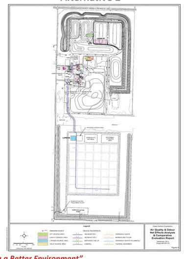
43 Alternative 2 Conceptual Design New shallow entombed landfill south of the existing Lambton Facility. Top of waste m AMSL (peak) with 3% top slope. Final cover 5.1 m native compacted clay with a vegetation layer on top. Landfill disposal area of 38.7 ha within total site area of ha. Waste disposal capacity approx. 3.6 million m m buffer zones on east, west, and south sides. Entrance to the existing facility will be utilized and an on-site access road will be constructed through the woodlot. Maintain existing waste processing and water management systems at the existing Lambton Facility. Existing Lambton Landfill closed as per approved closure plan. Perimeter landscaped screening berms approx. 6 m high with 3:1 side slopes. Excavation base of 187 m AMSL (13 m below ground surface). Clay key at the perimeter of the cell a minimum of 5.1 m deep and 5 m wide, constructed of re-compacted clay from the site. Stormwater management: o Ditching designed to accommodate at a minimum runoff from 1:25 year rain event; o Detention of runoff for the 1:100 year storm (at a minimum); o Surface water treatment at a rate of 2 million litres per day or use the existing Lambton Facility plant that has an approved rate of 4.5 million litres per day; and o Surface water management pond at south end. Process water transferred from pond via forcemain to Lambton Facility for disposal. Leachate transferred from covered pond to Lambton Facility incinerator by forcemain. Monitoring program consistent with Lambton Facility monitoring program and augmented as required. Cross-section of Alternative 2

44 Alternative 2 Conceptual Design
 associated with each alternative for each indicator and assign a preference rating (i.e., Preferred, Not Preferred, No Substantial Difference); and 2.")
45 Net Effects Analysis and Comparative Evaluation Process As part of the EA, a Net Effects Analysis was carried out for Alternative 1 and 2 consisting of the following: A Comparative Evaluation was then conducted by each discipline consisting of the following: 1. Identify the predicted net effect(s) associated with each alternative for each indicator and assign a preference rating (i.e., Preferred, Not Preferred, No Substantial Difference); and 2. Rate each alternative at the criteria level (i.e., Preferred, Not Preferred, No Substantial Difference) based on the identified preference rating for each indicator. PeopleandTechnologyCreatingaBetterEnvironment
46 Technical Net Effects Analysis and Comparative Evaluation The Net Effects and Comparative Evaluation for the Technical Environment were conducted using the following criteria and indicators: Criteria Facility Characteristics Indicators Complexity of site infrastructure changes. Complexity of engineered components, including their demonstrated or predicted effectiveness, longevity, maintenance, and/or replacement requirements. Operational flexibility. Interaction and integration with existing site infrastructure. Summary of the Net Effects Analysis: Alternative 1: Alternative 2: Low overall complexity of site infrastructure and overall complexity of engineered components given appropriate construction techniques, oversights and operation monitoring. Operational flexibility is maximized. High interaction and integration with existing site infrastructure. Low overall complexity of site infrastructure and overall complexity of engineered components given appropriate construction techniques, oversights and operation monitoring. Operational flexibility is maximized. Low level of interaction and integration with the existing site infrastructure. Summary of the Comparative Evaluation: Alternative 1 is preferred as there is no substantial difference for complexity of site infrastructure changes, complexity of engineered components, and operational flexibility and Alternative 1 is preferred over Alternative 2 with respect to interaction and integration with existing site infrastructure.


47 Geology and Hydrogeology Existing Conditions Regional & Local Geology Geology within the Regional and Local Study Areas is relatively uniform, consisting of a thick sequence of clay and silt dominated sediment deposited in and adjacent to proglacial lakes during the Late Wisconsinan substage of the Quaternary. The overburden is about 20 m thick in the Petrolia area, 35 to 40 m thick in the general vicinity of the Facility property and up to 70 m thick near the St. Clair River. PeopleandTechnologyCreatingaBetterEnvironment


")
48 Geology and Hydrogeology Existing Conditions Natural Resources SUMMARY OF HOUSEHOLD WATER USE GROUNDWATER SUPPLY WELLS OIL & GAS WELLS Table 8.1 from Geology and Hydrogeology Existing Conditions Report (RWDI, 2014)


49 Geology and Hydrogeology Net Effects Analysis and Comparative Evaluation The Net Effects and Comparative Evaluation for the Geology and Hydrogeology were conducted using the following criteria and indicators: Criteria Indicators Predicted effect of landfill development on groundwater quantity on-site and off-site. Groundwater Quantity The evaluation of this indicator involves an initial assessment of the effect of the landfill design on the hydraulic gradients that develop. The effect is defined as the volume of leachate that is produced from infiltration through the landfill cover, and subsequently moves outward from the landfill through the shallow or deeper groundwater. Groundwater Quality Predicted effect of contaminant movement on groundwater quality on-site and off-site. The analysis involves estimating the potential mass release of chloride from the landfill expressed in kg/year to shallow and deep groundwater. Key Design Considerations and Assumptions: Alternative 1 Includes effects from existing Cell 18, Sub-cell 1&2, and ongoing extraction of groundwater from Cell 18, Sub-cell 3. Area receiving waste will be increased over the existing landfill area by approximately 4.65 ha as a result of infilling of existing open area between/adjacent to Existing Landfill. Engineered cover combined with leachate collection system (LCS) will reduce the current leachate level in the waste. Results in reduction in hydraulic gradients outward from landfill. Alternative 2 Includes effects from full Existing Landfill. Area receiving waste will be increased over the existing landfill area by approximately 38.7 ha. The design does not incorporate engineered features (i.e., engineered cover system and LCS).
50 Geology and Hydrogeology Net Effects Analysis and Comparative Evaluation Summary of the Geology and Hydrogeology Net Effects Analysis: Alternative 1: Will result in a net decrease in the volume of leachate and the chloride mass loading to surface water on-site due to the installation of an engineered cover over several landfill cells and sub-cells, and the installation of a perimeter leachate collection system. Engineered cover will reduce the outward hydraulic gradient that currently exists within portions of the Existing Landfill and will also result in a decrease in volume of leachate that would move out through the excavation sidewalls and base of the landfill and the chloride mass loading to surface water and the Interface Aquifer. Engineered cover and leachate collection systems will need to be operated and maintained for the active contaminating life span of the landfill. Alternative 2: Does not incorporate an engineered cover or leachate collection system. Expected leachate mound that will be produced in the landfill will induce the outward movement of leachate/waste constituents. Groundwater flow and chloride impact could be reduced by a change in the design of the landfill such that it is more consistent with the initial entombment concept or an engineered cover system could be applied to reduce infiltration. However, the impacts would still be greater than those of Alternative 1 given that the overall size of the area to receive the waste at closure will be substantially larger. Summary of the Comparative Evaluation: Alternative 1 is preferred given that it will have less impact on the quantity and quality of groundwater.

51 Surface Water Existing Conditions

52 Surface Water Net Effects Analysis and Comparative Evaluation The Net Effects and Comparative Evaluation for the Surface Water were conducted using the following criteria and indicators: Criteria Surface Water Quality Indicators Assessment of on-site and off-site surface water quality including any predicted impact from upward diffusion of chemicals from the waste. Surface Water Quantity Predicted water flows for existing and proposed site conditions.
53 Surface Water Net Effects Analysis and Comparative Evaluation Summary of the Surface Water Quantity Net Effects Analysis: Alternative 1: Alternative 2: Quantity: Will result in an improvement in surface water quantity volume and peak flow over the future baseline condition for the north site outlet and will result in similar surface water quantity volume and peak flow as the future baseline condition for the south site outlet. Quality: Maximum mass discharge of chloride (used as a surrogate parameter for assessing relative impact) from groundwater to surface water is expected to decline in comparison to anticipated loadings under future baseline conditions. Quantity: Includes an increase in site footprint requiring additional surface water quantity control infrastructure. Alternative 2 will result in no change in surface water quantity volume and peak flow over the future baseline condition for the north site outlet and will result in a notable increase in surface water quantity volume over the future baseline condition for the south site outlet. Peak flow rate at the south site outlet is improved through the implementation of the south surface water reservoir. Quality: Maximum mass discharge of chloride from groundwater to surface water is expected to increase significantly in comparison to anticipated loadings under future baseline conditions. Increased chloride loadings under Alternative 2 may result in an exceedance of Canadian Councils of Ministers of the Environment (CCME) guidelines for the long term protection of aquatic life. Summary of the Comparative Evaluation: From a surface water quantity perspective, Alternative 1 is preferred due to the favourable surface water quantity volume and peak flow rates at the north and south site outlet. Alternative 2 is not preferred due to the increase in surface water runoff volume released at the south site outlet. Alternative 2 also requires the implementation of additional surface water quantity control infrastructure. From a surface water quality perspective Alternative 1 is preferred due to the smaller overall waste footprint and engineered control features (i.e., leachate collection system design), which will result in a lesser impact from the landfill to surface water receptors.

54 Alternative1 Alternative2

55 Natural Environment Aquatic
56 Natural Environment Net Effects Analysis and Comparative Evaluation The Net Effects and Comparative Evaluation for the Natural Environment were conducted using the following criteria and indicators: Criteria Terrestrial Ecosystems Aquatic Ecosystems Indicators Predicted impact on vegetation communities due to landfill footprint, construction and operations onsite. Predicted impact on Wildlife Habitats due to landfill footprint, construction and operations on-site. Predicted impact on amphibian habitat and communities due to landfill footprint, construction and operations. Presence of known or identified Species at Risk and their habitats and the predicted impact of the proposed footprint, construction and operations. Predicted impact on aquatic habitat due to landfill footprint, construction and operations on-site. Predicted impact on fisheries due to construction and operations on-site. Presence of known or identified Species at Risk and their habitats and the predicted impact of the proposed footprint, construction and operation onsite.
57 Natural Environment Net Effects Analysis and Comparative Evaluation Summary of the Terrestrial Net Effects Analysis: Alternative 1: Alternative 2: With compensation plantings, no net loss of significant vegetation communities anticipated; however, there will be a longer term loss of mature swamp and mature forest as these areas will take many decades to mature. Net loss of 0.77 ha of other, less significant vegetation from the Southwest Woodlot; however, effects are considered minor due to the lower quality of the vegetation. No net loss of SWH or amphibian breeding locations. New forest edge will grow in naturally after several years minimizing the edge effects. Wildlife avoidance along forest edge of Southeast Woodlot. No net effects on Butternuts anticipated with the compensation planting and the survival of the seedlings. With compensation plantings, no net loss of significant vegetation communities anticipated; however, there will be a longer term loss of mature forest as these areas will take many decades to mature. Net loss of 1.97 ha of other, less significant vegetation; however, effects are considered minor due to the lower quality of the vegetation. No net loss of SWH or amphibian breeding locations. New forest edge will grow in naturally after several years minimizing the edge effects. Wildlife avoidance along forest edge of South Woodlot and the Southwest Woodlot. Barriers in wildlife movement due to chain-link fence.
58 Natural Environment Net Effects Analysis and Comparative Evaluation Summary of the Aquatic Net Effects Analysis: Aquatic ecosystems are anticipated to be primarily influenced under either Alternative design by changes in sedimentation, changes in flow regime and changes in surface water quality. Changes in sedimentation and changes in flow are anticipated to be controlled or mitigated through the operation of the Surface Water Treatment Plant. Surface water quality conditions contribute to the overall suitability of fish habitat for fish use. Based on the findings of the hydrogeology & geology and surface water net effects analysis and comparative evaluation reports, the following net effects to surface water quality are anticipated. Alternative 1: Alternative 2: Maximum mass discharge of chloride (used as a surrogate parameter for assessing relative impact) from groundwater to surface water is expected to decline in comparison to anticipated loadings under future baseline conditions which will result in no net effects to fish within the Equalization Reservoir and/or to fish or fish habitat off-site within the downstream receivers. Maximum mass discharge of chloride from groundwater to surface water is expected to increase significantly in comparison to anticipated loadings under future baseline conditions which likely impact the suitability of fish habitat for fish use off-site within the downstream receivers. Summary of the Comparative Evaluation of the Natural Environment: Alternative 2 is slightly preferred from a terrestrial ecosystem perspective due to a lesser amount of significant forest vegetation removal and no net effects on Species at Risk. Alternative 1 is preferred from an aquatic ecosystems perspective due to the overall smaller waste footprint, one point discharge for off-site drainage and lesser potential for flooding implications and the lower projected mass discharge of chloride from groundwater to surface water. Overall, Alternative 1 is preferred in terms of effects on the natural environment.
59 Air Quality and Odour Net Effects Analysis and Comparative Evaluation The Net Effects and Comparative Evaluation for Air Quality and Odour were conducted using the following criteria and indicators: Criteria Air Emissions Indicators Predicted off-site point of impingement concentrations (g/m 3 ) of indicator compounds. Number of off-site receptors potentially affected (residential properties, public facilities, businesses/farms, institutions). Odour Predicted off-site odour concentrations (g/m 3 and odour units). Number of off-site receptors potentially affected (residential properties, public facilities, businesses/farms, institutions). Covered Leachate Ponds
60 Air Quality and Odour Net Effects Analysis and Comparative Evaluation Summary of the Net Effects Analysis: Alternative 1: Alternative 1 has slightly higher potential off-site point of impingement (POI) concentrations than Alternative 2; however, the difference is not considered substantial. o All potential off-site air quality impacts from the Facility comply with the MOE health and risk based Air Quality Standards. The total number of receptors potentially affected by off-site POI concentrations is the same for each Alternative. o Receptors closest to the proposed landfill are already in the vicinity of the existing landfill and the net change in effects is not considered significant. Under normal operations, there are no off-site odour impacts from the Facility; however, under an upset scenario, potential off-site odour concentrations would be the same for either Alternative. Alternative 2: All potential off-site air quality impacts from the Facility comply with the MOE health and risk based Air Quality Standards. Receptors closest to the proposed landfill are not currently in the vicinity of the existing landfill, and the net change in effects at these receptors is more significant than the net change for Alternative 1. Summary of the Comparative Analysis: Potential fugitive dust emissions from the short-term construction activities for each Alternative were considered to provide further insight into which Alternative is preferred. o Alternative 2 would require further mitigation measures than Alternative 1; therefore, when considering short-term construction activities, Alternative 1 is the preferred Alternative. Alternative 2 presents a greater risk of an upset scenario regarding odour concentrations related to the leachate. Overall, Alternative 1 is preferred as it would have lower construction effects and a lower risk of an upset scenario regarding odour concentrations.

61 Air Quality and Odour Net Effects Analysis and Comparative Evaluation Alternative1 Alternative2 PeopleandTechnologyCreatingaBetterEnvironment
62 Noise Net Effects Analysis and Comparative Evaluation The Net Effects and Comparative Evaluation for Noise were conducted using the following criteria and indicators: Criteria Noise Emissions Indicators Predicted off-site noise level. Number of off-site receptors potentially affected including residential properties, public facilities, businesses, farms and institutions. Summary of the Net Effects Analysis: Alternative 1: All receptors will remain below the MOE noise limits for landfill operations. The off-site environmental noise impact is limited to the 8 residents to the north. The most affected receptor will experience a net increase of 1 dba which is considered acoustically insignificant. Alternative 2: All receptors will remain below the MOE noise limits for landfill operations. The 5 residents to the south of the Study Area will experience a noise increase of more than 10 dba. A greater than 10 dba change in sound is perceived as twice as loud. Summary of the Comparative Evaluation: Alternative 1 is preferred as it provides the lowest noise impact exposure for the majority of the off-site receptors.

63 Noise Net Effects Analysis and Comparative Evaluation Alternative1 Alternative2 PeopleandTechnologyCreatingaBetterEnvironment
64 Socio-Economic Net Effects Analysis and Comparative Evaluation The Net Effects and Comparative Evaluation for the Socio-Economic Environment were conducted using the following criteria and indicators: Criteria Economic Social Indicators Opportunities to provide goods or services. Change in municipal tax base resulting from change in land use. The relative number and levels of jobs at the facility, in the community and among suppliers that are created/sustained during construction and operations. The relative dollar values of construction and operations of the project in terms of contribution to the local economy. Displacement of business activities. Effects on Municipal revenues (e.g., fees, service charges) and expenditures (e.g., costs associated with providing services to the site and other responsibilities such as participating in monitoring activities). Existing off-site businesses and numbers of employees within 500, 1,000 and 1,500 m of the landfill site boundary. Presence of known or identified Petroleum Resources or related abandoned infrastructure/wells and the predicted impact of the proposed footprint, construction and operation on-site. Presence of known or identified Aggregate Resources and the predicted impact or impairment of their use due to the proposed footprint, construction and operation on-site. Nuisances caused by weeds due to exposed site area and berms. Existing off-site residents within 500 m of the landfill boundary. Existing off-site residents within 1,000 m of the landfill boundary. Existing off-site residents within 1,500 m of the landfill boundary. Predicted changes in landscapes and views.
65 Socio-Economic Net Effects Analysis and Comparative Evaluation Summary of the Net Effects Analysis: Alternative 1: Economic: No net effects on the municipal tax base, displacement of business activities, municipal revenues, businesses and employees within the Study Area, petroleum resources or aggregate resources. Some positive net effects on opportunities to provide goods and services, the number and levels of jobs in the community and the dollar value of construction and operation activities. Social: No effects on the use and enjoyment of residences within 1,500 m are anticipated; however, there will be a few locations where the landfill will be visible from off-site due to the lower berm elevation in the vicinity of the site entrances. Alternative 2: Economic: No net effects on the displacement of business activities, municipal revenues, businesses and employees within the Study Area, petroleum resources or aggregate resources. Some positive net effects on the opportunities to provide goods and services, changes in the municipal tax base, the number and levels of jobs in the community, the dollar value of construction and operation activities and municipal revenues. Social: Negative effects identified for all social criteria indicators off-site residences within 500, 1,000 and 1,500 m and predicted changes in landscape and views. Summary of the Comparative Evaluation: Alternative 2 is anticipated to generate slightly more property tax revenue for the Municipality than Alternative 1. For this reason, Alternative 2 is preferred over Alternative 1 with regard to the Economic indicators, although the difference is considered relatively minor. Given that Alternative 1 is preferred in terms of all social indicators and the difference in economic indicators is minor, overall, Alternative 1 is preferred.
66 Agriculture Net Effects Analysis and Comparative Evaluation The Net Effects and Comparative Evaluation for Agricultural Resources were conducted using the following criteria and indicators: Criteria Agriculture Resources Indicators Displacement of high quality agricultural lands. Agriculture operational impacts. Particulate (dust) emissions from landfill. Nuisances caused by weeds due to exposed site area and berms. Summary of the Net Effects Analysis: Alternative 1: May require a shift in the southern property boundary by 153 m to be consistent with the buffer requirements of the existing zoning by-law. Results in the displacement of 1.9 ha of Class 2 lands, 9.7 ha of Class 3 lands and the loss of 2.2 ha of Disturbed Lands. Alternative 2: Results in the displacement of 45.0 ha of Class 2 lands, 73.8 ha of Class 3 lands which represent approximately 97.1 % of the Alternative 2 Study Area (the remaining 2.9% comprises Disturbed Lands). Summary of the Comparative Evaluation: Alternative 1 and Alternative 2 would have no substantial difference with respect to agricultural operation impacts (i.e. particulate emissions from the landfill and nuisances caused by weeds due to the exposed site area and berms). Alternative 1 is preferred as it would displace less high quality agricultural lands and there is no substantial difference for agricultural operational impacts.
67 Archaeology and Cultural Heritage Net Effects Analysis and Comparative Evaluation The Net Effects and Comparative Evaluation for the Archaeology and Cultural Heritage were conducted using the following criteria and indicators: Criteria Archaeological Resources Above Ground Cultural Heritage Resources Indicators Presence of known archaeological resources. Potential effects on archaeological potential. Presence of built heritage resources or cultural heritage landscapes. Presence of designated (Ontario Heritage Act), commemorated (National Historic Site or historical plaque) inventoried (listed on a municipal heritage register), and identified built heritage resources and cultural heritage landscapes in the site vicinity. Potential effects on above ground cultural heritage resources. Effects can include direct and indirect impacts. Direct impacts can include displacement through removal, while indirect impacts can include disturbance through the introduction of visual, audible, or atmospheric elements not in keeping with the surrounding setting.
68 Archaeology and Cultural Heritage Net Effects Analysis and Comparative Evaluation Summary of the Net Effects Analysis: Alternative 1: No known archaeological resources are present in the Alternative 1 Study Area. Potential net effects on areas with archaeological potential will be avoided or mitigated through conducting a Stage 2 Archaeological Assessment. No net effects on cultural heritage resources anticipated as the existing entrance to the site will continue to be used thus avoiding the identified cultural heritage resources. Alternative 2: No known archaeological resources are present in the Alternative 2 Study Area. Potential net effects on areas with archaeological potential will be avoided or mitigated through conducting a Stage 2 Archaeological Assessment. Although Telfer Road has been identified as a cultural heritage roadscape due to its narrow right-of-way and shoulders evocative of 19th century origins, it is not considered a unique resource. It is typical in this part of the County as such, with the implementation of the recommended mitigation measures, effects on the Telfer Road roadscape are not considered significant. Summary of the Comparative Evaluation: Given that there is no substantial difference for each criterion, overall there is no substantial difference between Alternative 1 and 2 in terms of Archaeological and Cultural Heritage Resources.
69 Comparative Evaluation of the Alternatives In addition to the comparison of the alternatives by Net Effects, the relative rankings of the criteria were used to help identify the Preferred Alternative. These rankings were confirmed as part of the approved Terms of Reference. Environmental Component Criteria Criteria Rank Agriculture Agricultural Resources Very Important Alternatives Alternative 1 Alternative 2 Atmospheric Environment (Air) Air Emissions Odour Very Important Very Important Archaeological and Cultural Heritage Resources Geology & Hydrogeology Archaeological Resources Above Ground Cultural Heritage Resources Groundwater Quantity Groundwater Quality Important Important Very Important Very Important No Substantial Difference No Substantial Difference No Substantial Difference No Substantial Difference No Substantial Difference Natural Environment Terrestrial Ecosystems Aquatic Ecosystems Very Important Very Important Atmospheric Environment (Noise) Noise Important Socio-Economic Economic Social Important Very Important Surface Water Surface Water Quality Surface Water Quantity Very Important Very Important Technical Facility Characteristics Very Important THE OVERALL PREFERRED ALTERNATIVE IS ALTERNATIVE 1


70 Preferred Alternative Birdseye View of the Existing Site Birdseye View of the Proposed Landfill at Closure
71 Cumulative Effects Assessment Clean Harbors has undertaken a cumulative effects assessment of air quality impacts and other Valued Ecosystem Components (VECs). Cumulative effects are effects that are likely to result from the proposed project in combination with other projects or activities that have been or will be carried out within the foreseeable future. Cumulative Effects Assessment Air Quality Two study areas were identified for the air cumulative effects assessment: o o Study Area 1: rectangular area that encloses every source of contaminants and extends 5 km from the existing facility boundary Study Area 2: the Aamjiwnaang First Nation Community, located 6 km northwest of the existing facility Study Area Study Area 1 Study Area 2 Methodology 1. Review air monitoring data for the existing facility. 2. Model particulate emissions from road dust and the resulting off-site concentrations for the alternatives. 3. Determine metal concentration in the modeled particulate matter for the alternatives. 4. Add the off-site metal concentrations to the road dust results for each alternative. 5. Add the maximum impact of fugitive volatile organic compound emissions from the existing landfill to the modelled impact from other facility sources. 6. Compare the resulting cumulative air quality effects to Ministry of the Environment (MOE) Point of Impingement (POI) limits and Ambient Air Quality Criteria (AAQC). 1. Using the air quality concentrations modeled for Study Area 1, add the maximum concentration of air pollutants from monitoring stations on the shore of the St. Clair River. 2. Compare the resulting cumulative air quality effects to MOE POI limits and Ambient Air Quality Criteria (AAQC). Results All compounds are below their respective POI and AAQC Standards Facility operations are not a significant contributor to emissions within the study area.
72 Cumulative Effects Assessment Valued Ecosystem Components (VECs) VECs were identified as groundwater, surface water, terrestrial ecosystem, aquatic ecosystem, traffic and noise. The following steps were undertaken as part of the Cumulative Effects Assessment for the VECs: Assess residual effects Determine whether VECs exhibit measureable or demonstrable residual effects Identify other projects and activities Assess whether the residual effects act in a cumulative fashion with the effects of other existing and future projects and activities Identify cumulative effects Determine if the regional condition for the VECs would measurably change due to the residual project effects in combination with other project or activity effects Evaluate significance of cumulative effects Identify whether the cumulative effect results in a significant adverse effect on relevant VECs in terms of magnitude, duration, extent or permanency Significance Assessment for the Residual Adverse Effects Residual Adverse Project Significance of VEC Affected Effects Phase Residual Effect Reduction in groundwater quality. Operation Groundwater Moderate Adverse Effect (Not Significant) Reduction in surface water quality. Operation Surface Water Moderate Adverse Effect (Not Significant) Some loss of vegetation and Construction/ Terrestrial Ecosystems Negligible Effect wildlife avoidance. Operation (Not Significant) Disruption to aquatic habitat. Operation Aquatic Ecosystems Moderate Adverse Effect (Not Significant) Disruption to local traffic. Construction/ Operation Traffic Negligible Effect (Not Significant) Increased noise levels around the site. Construction/ Operation Noise Negligible Effect (Not Significant) Based on the implementation of mitigation measures, the determination of significance of effects, and the context of this Project in conjunction with other activities, the Project is not likely to cause significant adverse cumulative environmental effects.
73 Advantages and Disadvantages of the Preferred Alternative Environmental Component Technical Geology & Hydrogeology Surface Water Natural Environment Air Quality Noise Socio- Economic Agriculture Archaeological & Cultural Heritage Advantages Site infrastructure and engineered components are standard components for landfills. Operational flexibility maximized. High degree of interaction and integration with existing site infrastructure. Reduced volume of leachate and chloride mass loading to surface water on-site and the Interface Aquifer. Less groundwater will be extracted and managed due to the smaller landfill footprint and the construction of engineered cover and leachate collection system. Reduced volume of impacted water discharging to surface water in future years. Improvement in surface water quantity volume and peak flow over the future baseline condition for the site outlet. Mass discharge of chloride from groundwater to surface water is expected to decline in future. With compensation plantings, no net loss of significant vegetation communities, Butternut trees, significant wildlife habitat or amphibian breeding locations. No net effects to fish or fish habitat off-site within the downstream receivers. All potential off-site air quality impacts will comply with MOE standards. Leachate Management System will minimize net effects from odour. All receptors will remain below MOE noise limits for landfill operations. Increase in employment and opportunities for local vendors/suppliers during construction. Fugitive Dust and Odour Best Management Plan will avoid or minimize dust emissions. No agricultural land will be taken out of active production. Potential archaeological net effects avoided or mitigated through a Stage 2 Archaeological Assessment. No net effects on cultural heritage resources anticipated. Disadvantages Will eliminate on-site operation of the TDU, Spent Pot Liner processing and equipment laydown areas within the last five years of operation. Active collection and disposal of leachate required. Potential increase in runoff volume and peak flow rate to the site outlets. Net loss of 0.77 ha of less significant vegetation. Wildlife avoidance along forest edge of Southeast Woodlot. Potential off-site air quality impacts during construction. Off-site noise impact is limited to eight existing residential dwellings. Landfill will be visible from off site in a few locations due to the lower berm elevation in the vicinity of the site entrances. Net loss of 13.8 ha of Class 2, Class 3 lands and Disturbed Lands if setback is required. No disadvantages to Archaeological and Cultural Heritage Resources.
74 Next Steps Your feedback from this Open House will be considered along with those received from First Nations and review agencies in preparation of the Draft EA Report (Spring, 2014). The Draft EA Report will be made available for review on the Project s website, at the Township of St. Clair Municipal Office and other locations. Thank you! Thank you for attending today s Open House. Your input and participation is important to us. You are invited to submit written comments or questions via mail, electronic mail ( ) or fax to the addresses/numbers published below. You can also submit questions on our project information line at Michael E. Parker Director Environmental Compliance, Lambton Facility Clean Harbors Canada, Inc Telfer Road, RR#1, Corunna, ON, N0N 1G0 Fax: (519) parker.michaele@cleanharbors.com Larry Fedec, P.Eng. Project Manager, Lambton Landfill Project AECOM 105 Commerce Valley Drive West, 7th Floor, Markham, ON L3T 7W3 Fax: (905) larry.fedec@aecom.com Project website: Under the Freedom of Information and Protection of Privacy Act and the Environmental Assessment Act, unless otherwise stated in the submission, any personal information such as name, address, telephone number and property location included in a submission will become part of the public record files for this matter and will be released, if requested, to any person.
75 Appendix C Open House Presentation Tps.Docx
76 6/9/2014 Overview of Presentation Purpose and need for the landfill expansion Where we are in the EA Process The Alternatives under consideration Results of the Net Effects Analyses and Comparative Evaluation Next steps Purpose and Need for the Landfill Expansion Clean Harbors commenced an Environmental Assessment (EA) on March 30, 2011 to develop additional waste disposal capacity for the landfill at their Lambton Facility. The landfill which has been in operation for nearly 50 years receives hazardous waste materials from commercial, industrial, institutional and municipal sources. Approximately 4.5 to 5.0 million cubic metres of landfill capacity are required to continue to manage waste at the Lambton Facility over a 25 year period. The additional capacity will enable Clean Harbors to continue providing secure disposal service in Ontario. Where We are in the EA Process COMPLETED IN PROGRESS Public/Stakeholder, Agency, First Nations Consultation Public/Stakeholder, Agency, First Nations Review and Comment Public/Stakeholder, Agency, First Nations Consultation Public/Stakeholder, Agency, First Nations Review and Comment Step One Develop Proposed EA Terms of Reference (EA ToR) Step Two Provincial Approval of EA ToR Step Three EA Study Step Four Provincial Review of EA Study WE ARE HERE Background Documentation Proposed EA Terms of Reference Minister Approved EA Terms of Reference (Dec. 2010) Existing Conditions Net Effects Analysis and Comparative Evaluation Draft EA Report Environmental Assessment Act (EAA) Approval to to 2010 Initiate Implementation of Undertaking (2014) including Environmental Protection Act (EPA) Approvals Where We are in the EA Process Milestones to Date December 2010 o Terms of Reference (ToR) for the Lambton Landfill expansion was approved by the Minister of the Environment. March 2011 o Commencement of Environmental Assessment. March 2013 o Completion of existing conditions studies (sent to First Nations and review agencies). July/August 2013 o Completion of the Conceptual Design Report and Addenda (sent to First Nations and review agencies). January 2014 o Completion of net effects analyses and comparative evaluations (sent to First Nations and review agencies), including Open House. April 2014 o Identification of the preferred alternative, including Open House. The Alternatives Under Consideration Two Alternative methods considered to provide additional landfill capacity: o Alternative 1 - vertical expansion over the existing landfill; and o Alternative 2 - shallow entombed landfill to the south of the existing facility. 1
77 6/9/2014 Alternative 1 Alternative 2 Net Effects Analysis/ Comparative Evaluation As part of the EA, a Net Effects Analysis was carried out for Alternative 1 and 2 consisting of the following: 1. Identify potential effects (based on indicators) on the environment in combination with the currently approved landfill considering maximum predicted waste receipt levels for the maximum impact stage or worst-case scenario; 2. Identify mitigation measures to address potential environmental effects; and 3. Identify net environmental effects (effects remaining after taking mitigation measures into consideration. A Comparative Evaluation was then conducted by each discipline consisting of the following: 1. Identify the predicted net effect(s) associated with each alternative for each indicator and assign a preference rating (i.e., Preferred, Not Preferred, No Substantial Difference); and 2. Rate each alternative at the criteria level (i.e., Preferred, Not Preferred, No Substantial Difference) based on the identified preference rating for each indicator. Comparative Evaluation of the Alternatives In addition to the comparison of the alternatives by Net Effects, the relative rankings of the criteria were used to help identify the Preferred Alternative. These rankings were confirmed as part of the approved Terms of Reference. Environmental Component Criteria Criteria Rank Agriculture Agri cultural Resources Very Important Atmospheric Environment (Air) Archaeological and Cultural Heritage Resources Geology & Hydrogeology Natural Environment Atmospheric Environment (Noise) Socio-Economic Surface Water Ai r Emissions Odour Archaeological Resources Above Ground Cultural Heritage Resources Groundwater Quantity Groundwater Quality Terrestrial Ecosystems Aquatic Ecosystems Noi se Economic Social Surface Water Quality Surface Water Quantity Very Important Very Important Important Important Very Important Very Important Very Important Very Important Important Important Very Important Very Important Very Important Technical Facility Characteristics Very Important THE OVERALL PREFERRED ALTERNATIVE IS ALTERNATIVE 1 Alternatives Alternative 1 Alternative 2 No Substantial No Substantial Difference Difference No Substantial No Substantial Difference Difference No Substantial Difference Advantages and Disadvantages of the Preferred Alternative Environmental Advantages Disadvantages Component Site infrastructure and engineered components are standard components for landfills. Will eliminate on-site operation of the Operational flexibility maximized. TDU, Spent Pot Liner processing and Technical High degree of interaction and integration with existing site infrastructure. equipment laydown areas within the last five years of operation. Reduced volume of leachate and chloride mass loading to surface water on-site and Active collection and disposal of the Interface Aquifer. leachate required. Geology & Less groundwater will be extracted and managed due to the smaller landfill footprint Hydrogeology and the construction of engineered cover and leachate collection system. Reduced volume of impacted water discharging to surface water in future years. Improvement in surface water quantity volume and peak flow over the future baseline Potential increase in runoff volume and condition for the site outlet. peak flow rate to the site outlets. Surface Water Mass discharge of chloride from groundwater to surface water is expected to decline in future. With compensation plantings, no net loss of significant vegetation communities, Net loss of 0.77 ha of less significant Natural Butternut trees, significantwildlife habitat or amphibian breeding locations. vegetation. Environment No net effects to fish or fish habitat off-site within the downstream receivers. Wildlife avoidance along forest edge of Southeast Woodlot. All potential off-site air quality impacts will comply with MOE standards. Potential off-site air quality impacts Air Quality Leachate Management System will minimize net effects from odour. during construction. All receptors will remain below MOE noise limits for landfill operations. Off-site noise impact is limited to eight Noise existing residential dwellings. Increase in employment and opportunities for local vendors/suppliers during Landfill will be visible from off site in a Socio- construction. few locations due to the lower berm Economic elevation in the vicinity of the site entrances. Fugitive Dust and Odour Best Management Plan will avoid or minimize dust Net loss of 13.8 ha of Class 2, Class 3 Agriculture emissions. lands and Disturbed Lands if setback is No agricultural land will be taken out of active production. required. Archaeological Potential archaeological net effects avoided or mitigated through a Stage 2 No disadvantages to Archaeological and & Cultural Archaeological Assessment. Cultural Heritage Resources. Heritage No net effects on cultural heritage resources anticipated. Birdseye View of the Proposed Landfill at Closure Next Steps Prepare Draft EA Report (Spring 2014) o Consultation Milestone Draft EA Review (First Nations, Township, Agencies and Public/Stakeholders) Prepare Final EA Report (Summer 2014) o Consultation Milestone Final EA Review (First Nations, Township, Agencies and Public/Stakeholders) Notice of EA Completion and Submission of EA Report for Ministry of the Environment Review (Summer 2014) o Developed based on the approved ToR requirements 2
78 6/9/2014 Thank You Questions/Comments Contact Information: Michael E. Parker Director Environmental Compliance, Lambton Facility Clean Harbors Canada, Inc Telfer Road, RR#1, Corunna, ON, N0N 1G0 Fax: (519) Larry Fedec, P.Eng. Project Manager, Lambton Landfill Project AECOM 105 Commerce Valley Drive West, 7th Floor, Markham, ON L3T 7W3 Fax: (905)
79 Appendix D Open House Flyer Tps.Docx


80
81 Supporting Document 1: Record of Consultation Presentation at Aamjiwnaang First Nation Environmental Carnival July 12, 2104


82 July 12, 2014 Overview of Presentation Purpose and need for the landfill expansion Where we are in the EA Process The Alternatives under consideration Results of the Net Effects Analyses and Comparative Evaluation Next steps Purpose and Need for the Landfill Expansion Clean Harbors commenced an Environmental Assessment (EA) on March 30, 2011 to develop additional waste disposal capacity for the landfill at their Lambton Facility. The landfill which has been in operation for nearly 50 years receives hazardous waste materials from commercial, industrial, institutional and municipal sources. Approximately 4.5 to 5.0 million cubic metres of landfill capacity are required to continue to manage waste at the Lambton Facility over a 25 year period. The additional capacity will enable Clean Harbors to continue providing secure disposal service in Ontario. Where We are in the EA Process COMPLETED IN PROGRESS Public/Stakeholder, Agency, First Nations Consultation Public/Stakeholder, Agency, First Nations Review and Comment Public/Stakeholder, Agency, First Nations Consultation Public/Stakeholder, Agency, First Nations Review and Comment Step One Develop Proposed EA Terms of Reference (EA ToR) Step Two Provincial Approval of EA ToR Step Three EA Study Step Four Provincial Review of EA Study WE ARE HERE Background Documentation Proposed EA Terms of Reference Minister Approved EA Terms of Reference (Dec. 2010) Existing Conditions Net Effects Analysis and Comparative Evaluation Draft EA Report Environmental Assessment Act (EAA) Approval to to 2010 Initiate Implementation of Undertaking (2015) including Environmental Protection Act (EPA) Approvals Where We are in the EA Process Milestones to Date December 2010 o Terms of Reference (ToR) for the Lambton Landfill expansion was approved by the Minister of the Environment. March 2011 o Commencement of Environmental Assessment. March 2013 o Completion of existing conditions studies (sent to First Nations and review agencies). July/August 2013 o Completion of the Conceptual Design Report and Addenda (sent to First Nations and review agencies). January 2014 o Completion of net effects analyses and comparative evaluations (sent to First Nations and review agencies), including AFN Community Information Session in March. April 2014 o Identification of the preferred alternative. July 2014 o Release of Draft Environmental Assessment Report The Alternatives Under Consideration Two Alternative methods considered to provide additional landfill capacity: o Alternative 1 - vertical expansion over the existing landfill; and o Alternative 2 - shallow entombed landfill to the south of the existing facility. 1
83 July 12, 2014 Alternative 1 Alternative 2 Net Effects Analysis/ Comparative Evaluation As part of the EA, a Net Effects Analysis was carried out for Alternative 1 and 2 consisting of the following: 1. Identify potential effects (based on indicators) on the environment in combination with the currently approved landfill considering maximum predicted waste receipt levels for the maximum impact stage or worst-case scenario; 2. Identify mitigation measures to address potential environmental effects; and 3. Identify net environmental effects (effects remaining after taking mitigation measures into consideration. A Comparative Evaluation was then conducted by each discipline consisting of the following: 1. Identify the predicted net effect(s) associated with each alternative for each indicator and assign a preference rating (i.e., Preferred, Not Preferred, No Substantial Difference); and 2. Rate each alternative at the criteria level (i.e., Preferred, Not Preferred, No Substantial Difference) based on the identified preference rating for each indicator. Comparative Evaluation of the Alternatives In addition to the comparison of the alternatives by Net Effects, the relative rankings of the criteria were used to help identify the Preferred Alternative. These rankings were confirmed as part of the approved Terms of Reference. Environmental Preferred Alternative Criteria Criteria Rank Component Alternative 1 Alternative 2 Agriculture Agricultural Resources Very Important Preferred Alternative (Environmental Component Level) Archaeological Important No Substantial No Substantial Archaeological and Resources Difference Difference Cultural Heritage Resources Above Ground Cultural Important No Substantial No Substantial Heritage Resources Difference Difference Preferred Alternative (Environmental Component Level) No Substantial Difference Atmospheric Air Emissions Very Important Environment Odour Very Important (Air Quality and Odour) Preferred Alternative (Environmental Component Level) Noise Noise Important Preferred Alternative (Environmental Component Level) Groundwater Quantity Very Important No Substantial No Substantial Geology & Difference Difference Hydrogeology Groundwater Quality Very Important No Substantial No Substantial Difference Difference Preferred Alternative (Environmental Component Level) No Substantial Difference Surface Water Quality Very Important Surface Water Surface Water Quantity Very Important Preferred Alternative (Environmental Component Level) Terrestrial Ecosystems Very Important Natural Environment Aquatic Ecosystems Very Important Preferred Alternative (Environmental Component Level) Economic Important Socio-Economic Disruption to Use* Very Important (Social ) Preferred Alternative (Environmental Component Level) Site Development and Important No Substantial No Substantial Technical Operating Requirements* Difference Difference (Facility Characteristics) Preferred Alternative (Environmental Component Level) No Substantial Difference PREFERRED ALTERNATIVE Advantages and Disadvantages of the Preferred Alternative Environmental Advantages Disadvantages Component Site infrastructure and engineered components are standard components for landfills. Will eliminate on-site operation of the Operational flexibility maximized. TDU, Spent Pot Liner processing and Technical High degree of interaction and integration with existing site infrastructure. equipment laydown areas within the last five years of operation. Reduced volume of leachate and chloride mass loading to surface water on-site and Active collection and disposal of the Interface Aquifer. leachate required. Geology & Less groundwater will be extracted and managed due to the smaller landfill footprint Hydrogeology and the construction of engineered cover and leachate collection system. Reduced volume of impacted water discharging to surface water in future years. Improvement in surface water quantity volume and peak flow over the future baseline Potential increase in runoff volume and condition for the site outlet. peak flow rate to the site outlets. Surface Water Mass discharge of chloride from groundwater to surface water is expected to decline in future. With compensation plantings, no net loss of significant vegetation communities, Net loss of 0.77 ha of less significant Natural Butternut trees, significantwildlife habitat or amphibian breeding locations. vegetation. Environment No net effects to fish or fish habitat off-site within the downstream receivers. Wildlife avoidance along forest edge of Southeast Woodlot. All potential off-site air quality impacts will comply with MOE standards. Potential off-site air quality impacts Air Quality Leachate Management System will minimize net effects from odour. during construction. All receptors will remain below MOE noise limits for landfill operations. Off-site noise impact is limited to eight Noise existing residential dwellings. Increase in employment and opportunities for local vendors/suppliers during Landfill will be visible from off site in a Socio- construction. few locations due to the lower berm Economic elevation in the vicinity of the site entrances. Fugitive Dust and Odour Best Management Plan will avoid or minimize dust Net loss of 13.8 ha of Class 2, Class 3 Agriculture emissions. lands and Disturbed Lands if setback is No agricultural land will be taken out of active production. required. Archaeological Potential archaeological net effects avoided or mitigated through a Stage 2 No disadvantages to Archaeological and & Cultural Archaeological Assessment. Cultural Heritage Resources. Heritage No net effects on cultural heritage resources anticipated. Birdseye View of the Proposed Landfill at Closure Next Steps Review of Draft EA Report (July 2014) o Consultation Milestone Draft EA Review (First Nations, Township, Agencies and Public/Stakeholders) Prepare Final EA Report (Summer 2014) o Consultation Milestone Final EA Review (First Nations, Township, Agencies and Public/Stakeholders) Notice of EA Completion and Submission of EA Report for Ministry of the Environment Review (Summer 2014) o Developed based on the approved ToR requirements 2
84 July 12, 2014 Thank You Questions/Comments Contact Information: Michael E. Parker Director Environmental Compliance, Lambton Facility Clean Harbors Canada, Inc Telfer Road, RR#1, Corunna, ON, N0N 1G0 Fax: (519) Larry Fedec, P.Eng. Project Manager, Lambton Landfill Project AECOM 105 Commerce Valley Drive West, 7th Floor, Markham, ON L3T 7W3 Fax: (905)
85 Supporting Document 1: Record of Consultation Notes of Meeting with Aamjiwnaang First Nation and Walpole Island First Nation September 30, 2014
86 AECOM 105 Commerce Valley Drive West, Floor tel Markham, ON, Canada L3T 7W fax Meeting Notes Date of Meeting September 30, 2014 Start Time 9:00 AM Project Number Project Name Location Regarding Attendees Minutes Prepared By Clean Harbors Landfill Expansion Environmental Assessment 4090 Telfer Road, Brigden, Ontario Comments received on Draft EA and next steps Mike Parker, Clean Harbors Dean Jacobs, Walpole Island First Nation Christine Rogers, Aamjiwnaang First Nation Courtney Jackson, Aamjiwnaang First Nation Kent Hunter, Neegan Burnside Joy Rutherford, Neegan Burnside Gunther Funk, RWDI Jim Yardley, CRA Larry Fedec, AECOM Julia Cushing, AECOM Julia Cushing, AECOM PLEASE NOTE: If this report does not agree with your records of the meeting, or if there are any omissions, please advise, otherwise we will assume the contents to be correct. The purpose of the meeting is to review responses to comments received from the First Nation on the Draft EA Responding to comments received Clean Harbors outlined the process undertaken for responding to comments received from the Township of St. Clair Clean Harbors developed a series of commitments to address the comments received The Township would be reviewing these commitments in a council meeting and Clean Harbors will include these commitments in the EA Clean Harbors is interested in developing similar commitments for the Walpole Island First Nation and the Aamjiwnaang First Nation Clean Harbors will provide the Walpole Island First Nation and the Aamjiwnaang First Nation with a series of commitments for discussion Groundwater and Surface Water RWDI confirmed that they had reviewed the previous comment response tables and in any location where it was indicated changes had been made, but the changes had not been reflected in the EA, the EA would be updated and corrected N/A Action Clean Harbors to provide the Walpole Island First Nation and the Aamjiwnaang First Nation with letters detailing the commitments to be included in the EA RWDI to update comment response tables to include section references and to make updates to the EA, where required; H _SD E2 MIN-AFN And WIFN Meeting Notes Docx
87 Page 2 Meeting notes September 30, 2014 RWDI also included section references in the comment response tables to facilitate Neegan Burnside s review Neegan Burnside identified a discrepancy with the description of the clay plug, CRA indicated the drawing will be corrected RWDI and CRA discussed the purpose for / location of the clay plug and indicated it would be approximately 5 m deep Neegan Burnside questioned if the clay plug would be deep enough RWDI responded that the active fracture zone is only approximately 3 m deep RWDI discussed the hydraulic control trench and indicated the specific design details would be determined in the ECA Neegan Burnside questioned if the hydraulic control trench would be deep enough RWDI responded that data collection would occur during the ECA to confirm the depth of the fracture zone CRA described the surface water management system proposed for Alternative 1 this included the mechanisms for managing water during rain events Annual Monitoring Report Clean Harbors proposed a new process going forward for reviewing the annual monitoring report Clean Harbors would like to meet with Neegan Burnside, the Aamjiwnaang First Nation and Walpole Island First Nation after receiving their initial comments to clarify any questions/comments prior to developing responses Neegan Burnside raised concerns with ensuring pumps would run after the facility closes Clean Harbors indicated they are required to provide financial assurance to ensure the facility will be maintained after it closes Clean Harbors also committed to including weather conditions in annual report to account for any standing water depicted in photos from the site RWDI committed to indicating well pairs in future annual reports Commitments Clean Harbors to provide a list of commitments to the Walpole Island First Nation and the Aamjiwnaang First Nation in response to their comments received on the Draft EA These commitments are draft for discussion and Clean Harbors will continue to follow up with Walpole Island First Nation and the Aamjiwnaang First Nation to finalize the commitments Clean Harbors also discussed including Walpole Island First Nation and the Aamjiwnaang First Nation in the development and implementation of the Habitat Compensation Plan, as outlined in the EA report Other AECOM indicated that the previous First Nation Comment Response Tables were reviewed by each discipline and in locations where changes weren t made, the EA report was updated, and section references were included in the report CRA to correct figures depicting clay plug Clean Harbors, Neegan Burnside, the Aamjiwnaang First Nation and Walpole Island First Nation to have meetings to discuss preliminary comments and responses regarding the annual report; Clean Harbors to include weather conditions in annual report; RWDI to indicate well pairs in future annual reports Clean Harbors to provide the Walpole Island First Nation and the Aamjiwnaang First Nation with letters detailing the commitments to be included in the EA; Clean Harbors to include Walpole Island First Nation and the Aamjiwnaang First Nation in the development and implementation of the Habitat Compensation Plan N/A H _SD E2 MIN-AFN And WIFN Meeting Notes Docx
88 Supporting Document 1: Record of Consultation Notes of Meeting with Aamjiwnaang First Nation October 1, 2014
89 Meeting Notes Date of Meeting October 1, 2014 Start Time Project Number Project Name Location Regarding Attendees Clean Harbors Lambton Landfill Expansion Environmental Assessment Aamjiwnaang Environment Department, 978 Tashmoo Avenue Sarnia, ON Lambton Landfill Expansion Environmental Assessment Christine Rogers, Aamjiwnaang First Nation Sharilyn Johnston, Aamjiwnaang First Nation Bonnie Plain, Aamjiwnaang First Nation Kent Hunter, Neegan Burnside Ann Butler, Mike Parker, Clean Harbors PLEASE NOTE: If this report does not agree with your records of the meeting, or if there are any omissions, please advise, otherwise we will assume the contents to be correct. The following is a record of discussion points between Clean Harbors Canada Inc. and representatives of the Aamjiwnaang First Nation on October 1, Clean Harbors will be responding to Aamjiwnaang First Nation Draft Environmental Assessment (EA) Report comments in the Final EA Report. Most comments were related to items that will be dealt with in the Environmental Compliance Approval (ECA). Aamjiwnaang First Nation will receive a copy of the Final EA October 17, 2014 Based upon St. Clair Township s review of the Draft EA Report, the St. Clair Township Council had 17 recommendations to which Clean Harbors has made 13 commitments as an approach to address their recommendations. The company is proposing a similar approach to addressing the comments from Aamjiwnaang First Nation with 9 commitments. Aamjiwnaang First Nation would like to see a commitment around wildlife corridors to ensure that animals are not getting blocked. Mike Parker to send a Word document with the commitments to Aamjiwnaang First Nation for their review and comment. The company is looking at trying to minimize impacts to the woodlot such as bringing in special trench construction technology. The conceptual design will be enhanced in the final design detailed for the ECA. Financial assurance is a major component of the ECA and the company provides a financial bond to cover costs to monitor and decommission the site. Clean Harbors currently has financial assurance for the existing landfill. This amount will be reviewed and updated to reflect the design of the expansion in the ECA. Action Clean Harbors to address comments in the Final EA Report and/or ECA application Clean Harbors to submit proposed 9 commitments to Aamjiwnaang First Nation and include in the Final EA Report I _SD E2 MIN-AFN Meeting Minutes Docx
90 Page 2 Aamjiwnaang First Nation requested that the company set up Trust Fund / Legacy Fund to address issues for future generations. Clean Harbors is interested in donating to Aamjiwnaang First Nation programs like the Greenhouse project. Aamjiwnaang First Nation will send information. Community support of the EA is the decision of Aamjiwnaang First Nation Chief and Council. Aamjiwnaang First Nation will forward proposal / invoice for consultation for the EA. A detailed review of the comments on the 2013 Annual Monitoring Report and the 2014 Annual Monitoring Report will be undertaken. The next report is due on November 30, Clean Harbors would like to meet with Neegan Burnside and the Aamjiwnaang First Nation after receiving their initial comments to clarify any questions/comments prior to developing responses. The liaison meeting clashes with the Aamjiwnaang First Nation environmental meeting, Aamjiwnaang First Nation will send a new member. The company suggested Aamjiwnaang First Nation become a waste broker / sales agent / Suncor remediation / bio remediation. Return to Landscape to contact Mike regarding Butternut trees. The affected Butternut trees will be replaced at a ratio of 20:1. It was noted that one of the trees does not have the Butternut Canker fungus. New Butternut trees will be brought in and seeds will be checked. Information will be taken to the Aamjiwnaang Environment Committee next week and Clean Harbors will be contacted if there are any changes. A Council meeting will be held on November 6 or 13, 2014 at which point the Clean Harbors EA will be discussed. Aamjiwnaang First Nation to send information on the Greenhouse project Aamjiwnaang First Nation to send proposal/invoice for EA consultation Hold a meeting with Aamjiwnaang First Nation in early I _SD E2 MIN-AFN Meeting Minutes Docx
91 Supporting Document 1: Record of Consultation Appendix E3 Written Correspondence with Aboriginal Communities
92 Wong Ken, Michelle Subject: Attachments: FW: Clean Harbors Lambton EA CH EA-First Nation- Comments and Responses (Nov ).docx; CH-EA (Meeting Notes ).docx From: Fedec, Larry Sent: Monday, January 23, :35 AM To: 'Kent Hunter'; 'Tricia Radburn'; 'wplain'; Cc: 'Parker, Michael E'; 'DiNapoli, John J' Subject: Clean Harbors Lambton EA Hi Everyone As you are aware, effective December 22nd, 2011 Clean Harbors temporarily halted all activities related to their Lambton Landfill expansion environmental assessment (EA). This action was taken in order to allow the company to focus on the operational issues facing the Landfill at this time. Just prior to work on the EA being stopped, a meeting between Aamjiwnaang First Nation, Walpole Island First Nation, Neegan Burnside, Clean Harbors and AECOM was held at the Lambton site on November 14, The main focus of that meeting was to discuss the current site odour issues and actions being taken, review the EA status including the Nov. 9 th version of the comment/response table regarding the EA technical work plans, a discussion of annual monitoring reports, and a site tour to observe site drilling work and the landfill cap core. For your records, a copy of the Nov. 14 th meeting notes prepared by AECOM are attached. Subsequently a follow up telephone conversation was held on November 18 th between Neegan Burnside, AECOM and the Hydrogeology technical consultant to clarify some of the responses in the EA comment/response table. As a result of this discussion, some updates were made to responses in the Nov 9 th version of the EA comment/response table. For your records, a copy of the November 18 th, 2011 comment/response table regarding the EA work plans is attached. This information is provided for record keeping purposes only at this time and no further work activities related to this are authorized by Clean Harbors. Thank you again for your time and involvement in the EA. If you have any questions regarding the Lambton Landfill, please contact Mike Parker who has been copied on this . Regards..Larry Larry M. Fedec, P.Eng., M.B.A. Manager, Waste Services Environment D: ext.259 C: Larry.Fedec@aecom.com AECOM 300 Town Centre Boulevard, Suite 300, Markham, Ontario L3R 5Z6 T: F:


93


94
Comprehensive Study Scoping Document. for Lower Mattagami Hydroelectric Complex Redevelopment CEAR Reference Number:
 Comprehensive Study Scoping Document for Lower Mattagami Hydroelectric Complex Redevelopment CEAR Reference Number: 07-03-26302 Prepared pursuant to Subsection 21(1) of the Canadian Environmental Assessment
AECOM, 2014: Surface Water Existing Conditions Report. Prepared for Clean Harbors Canada, Inc.
 References AECOM, 2014: Surface Water Existing Conditions Report. Prepared for Clean Harbors Canada, Inc. ASI, 2009: Stage 1 Archaeological Assessment. Prepared for Clean Harbors Canada, Inc. Cadman, M.D.,
Factor Potential Effects Mitigation Measures
 Natural Environment No impacts of provincial significance to the natural environment are anticipated for the rapid transit project. Other impacts and how they will be mitigated are outlined in the table
WATERSHED. Maitland Valley. Report Card 201
 Maitland Valley WATERSHED Report Card 201 The Maitland Valley Conservation Authority has prepared this report card as a summary on the state of our forests, wetlands, surface water, and ground water resources.
Chapter 10 Natural Environment
 Chapter 10 Natural Environment Existing Conditions The Natural Environment Element addresses the protection, conservation, preservation, and restoration of the natural resources the Bayview Ridge Subarea,
Environmental Information Worksheet
 Environmental Information Worksheet Water System Owner (Attach additional sheets if necessary) Needs and Alternatives Provide a brief narrative that describes: Current drinking water system needs. Project
Public Information Centre No. 2
 Public Information Centre No. 2 Wednesday April 20, 2011 4:00 pm to 7:00 pm City of Welland City Hall Area 2 Welland, Pelham, and Port Colborne Welcome to Public Information Centre No. 2 Please sign in
7.0 COMPARATIVE EVALUATION OF ALTERNATIVE SITES AND IDENTIFICATION OF PREFERRED SITE
 7.0 COMPARATIVE EVALUATION OF ALTERNATIVE SITES AND IDENTIFICATION OF PREFERRED SITE As an initial step during the EA, Taggart Miller undertook a comparative Site selection assessment to identify a preferred
ENVIRONMENT ACT TERMS OF REFERENCE NOVA SCOTIA DEPARTMENT OF TRANSPORTATION AND PUBLIC WORKS. Beaver Bank Bypass
 ENVIRONMENT ACT TERMS OF REFERENCE NOVA SCOTIA DEPARTMENT OF TRANSPORTATION AND PUBLIC WORKS Beaver Bank Bypass Highway 101 to the Beaver Bank Road Halifax County, NS NOVA SCOTIA DEPARTMENT OF THE ENVIRONMENT
Information Requirements Table for Liquid Waste
 Applicant Summary Tracking # Authorization # Applicant / Facility Name Ministry of Environment Prepared by: Title Date The Information Requirements Table (IRT) for Liquid Waste is a tool used by Ministry
COLE ENGINEERING GROUP LTD.
 CITY OF MARKHAM PROJECT FILE Stormwater Management Facilities Retrofit Municipal Class EA ES12-0316 COLE ENGINEERING GROUP LTD SEPTEMBER 2015 [ Month Year ] HEAD OFFICE 70 Valleywood Drive Markham, ON
STORMWATER RUNOFF AND WATER QUALITY IMPACT REVIEW
 SUBCHAPTER 8 STORMWATER RUNOFF AND WATER QUALITY IMPACT REVIEW 7:45-8.1 Purpose and scope of review Except for those projects expressly exempted by this chapter or waived by the Commission, the Commission
GUIDE TO THE DEVELOPMENT OF A MINING AND RECLAMATION PLAN IN NEW BRUNSWICK
 PROVINCE OF NEW BRUNSWICK DEPARTMENT OF ENERGY AND RESOURCE DEVELOPMENT Minerals and Petroleum Development Branch GUIDE TO THE DEVELOPMENT OF A MINING AND RECLAMATION PLAN IN NEW BRUNSWICK Guide to the
Shell Quest Carbon Capture and Storage Project. Shell Canada Limited
 SCREENING SCOPING DOCUMENT For the proposed Shell Quest Carbon Capture and Storage Project Shell Canada Limited Prepared by: Canadian Environmental Assessment Agency Natural Resources Canada Fisheries
407 TRANSITWAY. Planning & Preliminary Design
 FROM EAST OF HIGHWAY 400 TO KENNEDY ROAD GWP #252-96-00 Public Information Centre #2 June 24 th and 29 th, 2010 Purpose of Public Information Centre #2 The first Public Information Centre (PIC #1) was
Municipal Class Environmental Assessment for Pottersburg Creek Slope Stability Study South of Hamilton Road, Schedule B
 Municipal Class Environmental Assessment for Pottersburg Creek Slope Stability Study South of Hamilton Road, Schedule B February 13, 2013 Municipal Class EA Process We are here Purpose and Objective of
ENVIRONMENTAL SCREENING REPORT
 ENVIRONMENTAL SCREENING REPORT Pursuant to the Canadian Environmental Assessment Act (CEA Act) SCREENING SUMMARY TransCanada PipeLines Limited (TransCanada) is proposing to conduct a contaminant sampling
February Reference Section in Supplemental. Reference Section in Consultants Reports. Reference Section in Application. TOR No.
 Request i Final Terms of Environmental Impact Assessment Report for Coal Valley Resources Inc. (CVRI) Proposed Robb Trend Project Cross (Concordance) Table to Location in ii PURPOSE OF THE TERMS OF REFERENCE
CLC Meeting 23 November 23, 2016 FACILITY CHARACTERISTICS, CLIMATE CHANGE & PLANNING ASSUMPTIONS
 CLC Meeting 23 November 23, 2016 FACILITY CHARACTERISTICS, CLIMATE CHANGE & PLANNING ASSUMPTIONS 1 Agenda 1. Preliminary Facility Characteristics 2. Climate Change Assumptions 3. Preliminary Planning Assumptions
Summary Statement PLANNING REPORT & AGGREGATE RESOURCES ACT. Part of Lot 3, Concessions 1 and 2, Township of Clearview, County of Simcoe OSTER PIT
 PLANNING REPORT & AGGREGATE RESOURCES ACT Summary Statement OSTER PIT Part of Lot 3, Concessions 1 and 2, Township of Clearview, County of Simcoe Date: October 2016 Prepared for: Lafarge Canada Inc. Prepared
Soil Treatment Facility Design and Operation for Bioremediation of Hydrocarbon Contaminated Soil. Version 1.0
 PROTOCOL 15 FOR CONTAMINATED SITES Soil Treatment Facility Design and Operation for Bioremediation of Hydrocarbon Contaminated Soil Version 1.0 Prepared pursuant to Section 64 of the Environmental Management
Manitoba s Submission Guidelines for Peatland Management Plans
 Manitoba s Submission Guidelines for Peatland Management Plans Peatland Management Guidebook Forestry and Peatlands Branch Manitoba Sustainable Development First Published: September 2017 Review by: 2022
Geology and Hydrogeology Existing Conditions Final Report
 Clean Harbors Canada, Inc. Lambton Landfill Expansion Environmental Assessment Geology and Hydrogeology Existing Conditions Final Report Prepared by: Tel: 289.205.0618 Fax: 519.823.1316 RWDI AIR Inc. 1100
LAND DEVELOPMENT AND PLANNING FORUM 2014 THE 2014 PROVINCIAL POLICY STATEMENT AND ENVIRONMENTAL PROTECTION
 LAND DEVELOPMENT AND PLANNING FORUM 2014 THE 2014 PROVINCIAL POLICY STATEMENT AND ENVIRONMENTAL PROTECTION MARY L. FLYNN-GUGLIETTI AND ANNIK FORRISTAL THE 2014 PROVINCIAL POLICY STATEMENT & ENVIRONMENTAL
Telephone Lake project
 Telephone Lake project Cenovus Energy Inc. is a Canadian oil company. We re committed to applying fresh, progressive thinking to safely and responsibly unlock energy resources the world needs. Our operations
Design Specifications & Requirements Manual
 Design Specifications & Requirements Manual 10 SEDIMENT AND EROSION CONTROL 10.1 INTRODUCTION... 1 10.2 REFERENCE... 1 10.3 GENERAL INFORMATION REQUIREMENTS... 1 10.3.1 ESC Plan... 1 10.3.2 Servicing Drawings...
E. STORMWATER MANAGEMENT
 E. STORMWATER MANAGEMENT 1. Existing Conditions The Project Site is located within the Lower Hudson Watershed. According to the New York State Department of Environmental Conservation (NYSDEC), Lower Hudson
Clifton Marsh Landfill Variation of planning permission 05/09/0376 & 06/09/0395 for the continuation of landfilling until Non Technical Summary
 Clifton Marsh Landfill Variation of planning permission 05/09/0376 & 06/09/0395 for the continuation of landfilling until 2035 Non Technical Summary SLR Consulting Limited Project Ref: 403.00079.00474
Viridor Waste Management. Proposed Development of an In-Vessel Composting Facility. Land at Exide Batteries, Salford Road, Bolton
 Viridor Waste Management Proposed Development of an In-Vessel Composting Facility Land at Exide Batteries, Salford Road, Bolton Non-Technical Summary January 2009 Introduction Viridor Waste Management
Section SNOW DISPOSAL SITE DESIGN CRITERIA
 Section 2.150 SNOW DISPOSAL SITE DESIGN CRITERIA 2.150 A. Introduction Snow disposal sites provide storage areas for snowfall that exceeds the storage capacity of street rights-of-way and other public
You have applied in accordance with Section 9 of the Environmental Protection Act for approval of:
 Ministry of the Environment Ministère de l Environnement CERTIFICATE OF APPROVAL AIR NUMBER 7970-7QNRDJ Issue Date: April 2, 2009 William Day Construction Limited 2500 Elm Street, P.O. Box 700 Copper Cliff,
Preferred Elevated Tank Site
 Preferred Elevated Tank Site Preferred Site No. 3 is on private property owned by Hopewell Developments. Approximately 5 acres of land will be required, including lands required for a permanent access
JEFFERSON COUNTY STORM WATER MANAGEMENT
 JEFFERSON COUNTY STORM WATER MANAGEMENT B-210 Courthouse, Birmingham, Alabama 35203 Telephone: (205) 325-8741 Erosion and Sedimentation Control Measures for Commercial Projects (Plans Requirements) -All
Welcome to the Boulevard Lake Dam Class Environmental Assessment. Public Information Session #1. June 14, 2016
 Welcome to the Boulevard Lake Dam Class Environmental Assessment Public Information Session #1 June 14, 2016 Boulevard Dam - Overview Built approximately 100 years ago Owned and operated by the City of
DECISION MEMO. West Fork Blacktail Deer Creek Hardened Crossing
 Page 1 of 6 Background DECISION MEMO USDA Forest Service Madison Ranger District Madison County T12S, R4W, Section 30 The project is in the Gravelly Landscape, Snowcrest Recommended Wilderness Management
Preface. MNR # Queen s Printer for Ontario, 2012 ISBN (PRINT) ISBN (PDF)
 ISBN (PDF)") Preface In 2008, the inter-agency Drainage Act & Section 28 Regulations Team (DART) was established by the Ministry of Natural Resources (MNR) and the Ministry of Agriculture, Food and Rural Affairs (OMAFRA)
Preface In 2008, the inter-agency Drainage Act & Section 28 Regulations Team (DART) was established by the Ministry of Natural Resources (MNR) and the Ministry of Agriculture, Food and Rural Affairs (OMAFRA)
C&B Alberta Solar Development ULC
 Decision 22781-D01-2017 Newell Solar Power Plant November 15, 2017 Alberta Utilities Commission Decision 22781-D01-2017 Newell Solar Power Plant Proceeding 22781 Application 22781-A001 November 15, 2017
Provincial Policy Statement 2014 Training Aid
 This job aid has been developed for education and training purposes as a high-level summary of the policy changes in the PPS 2014. It should not be relied upon as a substitute for specialized legal or
APPENDIX 2. Nova Scotia Department of Environment and Labour Environmental Assessment Terms and Conditions for Environmental Assessment Approval
 APPENDIX 2 Nova Scotia Department of Environment and Labour Terms and Conditions for Approval Approval Approval Date: March 14, 2007 Keltic Petrochemicals Inc. LNG and Petrochemical Plant Facilities Keltic
Content Copy Of Original
 Content Copy Of Original Ministry of the Environment Ministère de l Environnement ENVIRONMENTAL COMPLIANCE APPROVAL NUMBER 4495-9FUQDY Issue Date: February 5, 2014 Holcim (Canada) Inc. 2300 Steeles Ave
Understanding Stormwater Pollution Prevention Plans (SWPPPs) (SWPPPS)
 (SWPPPS)") Understanding Stormwater Pollution Prevention Plans (SWPPPs) (SWPPPS) Definitions SWPPP: Storm Water Pollution Prevention Plan BMP: Best Management Practice(s) to control pollution IDNR: Iowa Department
Understanding Stormwater Pollution Prevention Plans (SWPPPs) (SWPPPS) Definitions SWPPP: Storm Water Pollution Prevention Plan BMP: Best Management Practice(s) to control pollution IDNR: Iowa Department
Alternative Futures for the City of La Paz, Mexico
 O N T H E G R O U N D Alternative Futures for the City of La Paz, Mexico Caroline Dragoo University of Arizona and Robert Faris Harvard University La Paz, Mexico is working hard not to turn into Cabo San
CHAPTER 3 Environmental Guidelines for WATERCOURSE CROSSINGS GOVERNMENT OF NEWFOUNDLAND AND LABRADOR DEPARTMENT OF ENVIRONMENT AND LABOUR
 GOVERNMENT OF NEWFOUNDLAND AND LABRADOR DEPARTMENT OF ENVIRONMENT AND LABOUR CHAPTER 3 Environmental Guidelines for WATERCOURSE CROSSINGS WATER RESOURCES MANAGEMENT DIVISION Water Investigations Section
SOUTH FLORIDA WATER MANAGEMENT DISTRICT. Question 13: Wetlands
 SOUTH FLORIDA WATER MANAGEMENT DISTRICT Question 13: Wetlands 1. The wetland responses and topographical data provided in the ADA for the 520- acre project site are conceptual in nature. The referenced
Chapter MINERAL EXTRACTION AND MINING OPERATIONS
 Chapter 17.31 MINERAL EXTRACTION AND MINING OPERATIONS Sections: 17.31.010 Purpose 17.31.020 Procedure for Extraction and Rehabilitation Requests 17.31.030 Operation and Rehabilitation Standards for all
NEW CASTLE CONSERVATION DISTRICT. through. (Name of Municipality) PLAN REVIEW APPLICATION DRAINAGE, STORMWATER MANAGEMENT, EROSION & SEDIMENT CONTROL
 PLAN REVIEW APPLICATION DRAINAGE, STORMWATER MANAGEMENT, EROSION & SEDIMENT CONTROL") NEW CASTLE CONSERVATION DISTRICT through (Name of Municipality) PLAN REVIEW APPLICATION DRAINAGE, STORMWATER MANAGEMENT, EROSION & SEDIMENT CONTROL Office use only: Received by Municipality: Received by
NEW CASTLE CONSERVATION DISTRICT through (Name of Municipality) PLAN REVIEW APPLICATION DRAINAGE, STORMWATER MANAGEMENT, EROSION & SEDIMENT CONTROL Office use only: Received by Municipality: Received by
Site C Clean Energy Project Agricultural Mitigation and Compensation Plan
 Site C Clean Energy Project Agricultural Mitigation and Compensation Plan Revision 1: September 25, 2017 Table of Contents 1.0 Background... 4 1.1 The Site C Clean Energy Project... 4 1.2 Project Benefits...
Potential effects evaluation of dewatering an underground mine on surface water and groundwater located in a rural area
 Potential effects evaluation of dewatering an underground mine on surface water and groundwater located in a rural area ITRODUCTIO Michel Mailloux* Eng. M.Sc, Vincent Boisvert, M.Sc, Denis Millette, Eng.,
PROVINCIAL POLICY STATEMENT RELATION TO THE PROVINCIAL PLAN
 COUNTY OF LAMBTON OFFICIAL PLAN UPDATE BACKGROUND REPORT NO. 1 PROVINCIAL POLICY STATEMENT RELATION TO THE PROVINCIAL PLAN Image Source: (Word Clip Art Stock Photos, 2011) Date: May, 2015 BACKGROUND PLANNING
MURPHY DRAIN CATCHMENT
 The RVCA produces individual reports for 16 catchments in the Lower Rideau subwatershed. Using data collected and analysed by the RVCA through its watershed monitoring and land cover classification programs,
Report for Agenda Item: 2
 QLDC Council 28 September 2017 Department: Planning & Development Report for Agenda Item: 2 Stage 2 Proposed District Plan Notification Purpose The purpose of this paper is to present those parts of Stage
6 Risk assessment methodology
 Risk assessment methodology 6 Risk assessment methodology 6.1 Introduction INPEX has committed to a systematic risk assessment process as a means of achieving best practice in environmental management
2016 LANDFILL INSPECTION REPORT CARDINAL PLANT BRILLIANT, OHIO
 2016 LANDFILL INSPECTION REPORT GERS-16-004 CARDINAL PLANT BRILLIANT, OHIO PREPARED BY GEOTECHNICAL ENGINEERING AEP SERVICE CORPORATION 1 RIVERSIDE PLAZA COLUMBUS, OHIO Cardinal Plant Landfill Inspection
Operations Mine Site, Tote Road and Railway
 Operations Mine Site, Tote Road and Railway 2 Panel Members Michael Anderson Richard Cook John Binns Fernand Beaulac Steve Walker Mike Lepage Michael Sheahan 3 The Panel will address: FEIS Volumes 3, 5,
New Castle County, DE. Floodplain Regulations
 New Castle County, DE Floodplain Regulations John J. Gysling, PE CFM Department of Land Use New Castle County, DE February 26, 2009 Today s Presentation Floodplain Protection and Uses Terms and Definitions
Saturated Buffer. Subsurface Drainage PURPOSE N REDUCTION LOCATION COST BARRIERS
 Saturated Buffer To intercept tile drainage prior to discharging to surface waters and redistribute the water laterally in the soil profile of the streamside buffer. Subsurface drainage, also known as
COON CREEK WATERSHED DISTRICT PERMIT REVIEW. Spring Lake Park Schools Westwood Middle School st Avenue NE, Spring Lake Park, MN 55432
 PAN 16-112, Westwood Middle School, Page 1 of 6 COON CREEK WATERSHED DISTRICT PERMIT REVIEW MEETING DATE: August 22, 2016 AGENDA NUMBER: 10 FILE NUMBER: 16-112 ITEM: Westwood Middle School RECOMMENDATION:
Canadian Solar Developers Ltd.
 Canadian Solar Developers Ltd. Type of Document Draft Report Project Name Proposed Ground Mount Solar Facility L.P #5 8338 Scotchmere Drive, Strathroy, ON OPA FIT Program: FIT-FL67GB5 Project Number V00002250-00
Works, services and infrastructure code
 9.4.11 Works, services infrastructure code 9.4.11.1 Application (1) This code applies to assessable development identified as requiring assessment against the Works, services infrastructure code by the
SITE ALTERATION PERMIT INFORMATION PACKAGE FOR LAND OWNERS
 SITE ALTERATION PERMIT INFORMATION PACKAGE FOR LAND OWNERS Revised: June 4, 2014 Requirements for obtaining a site alteration permit vary depending on the type of project being proposed. This information
Closure Plan Ash Disposal Area PGE Boardman Power Plant
 FIRST ISSUE REVISION 0 Closure Plan Ash Disposal Area PGE Boardman Power Plant Prepared for Portland General Electric September 2015 2020 SW 4th Avenue, Suite 300 Portland, Oregon 97201 This document was
to get that license the ministry must first complete a detailed federal environmental assessment Defining environmental impacts
 Update May 2009 Deloro Mine Site Cleanup Project This is a critical year for the Deloro Mine Site Cleanup Project as the ministry finalizes engineering designs for the caps, covers and pumping stations
E7. Taking, using, damming and diversion of water and drilling
 E7. Taking, using, damming and diversion of water and drilling E7.1. Introduction Taking, using, damming and diversion of surface water and groundwater provisions in this plan apply in accordance with
British Columbia s. VVater Act. Modernization. Policy Proposal on British Columbia s new Water Sustainability Act. December 2010
 British Columbia s VVater Act Modernization Policy Proposal on British Columbia s new Water Sustainability Act December 2010 British Columbia has a rich heritage in our lakes, rivers and streams. Linked
Rural-Residential Rural-Residential Explanatory Statement Significant Issues Objectives and Policies...
 Section Contents Rural-Residential... 2 16. Rural-Residential... 2 Explanatory Statement... 2 16.1 Significant Issues... 2 16.2 Objectives and Policies... 3 16.3 Activity Lists... 3 16.4 Activity Performance
Section XXV Preconstruction Assessments and Damage Mitigation Procedures
 Section XXV Preconstruction Assessments and Damage Mitigation Procedures A. Introduction - In recent years, HRSD has received an increasing number of complaints from residents and locality staff regarding
Code of Practice for Land Treatment of Soil Containing Hydrocarbons
 Code of Practice for Land Treatment of Soil Containing Hydrocarbons September 2008 Made under the Environmental Protection and Enhancement Act RSA 2000, ce-12 Published by Alberta Queen s Printer Alberta
ENVIRONMENTAL ASSESSMENT OF THE PROPOSED CAPITAL REGION RESOURCE RECOVERY CENTRE VOLUME I
 Wilson-Johnston Municipal Drain: The post-development, final build-out sub-catchment area draining to the Wilson-Johnston Drain will decrease by approximately 11.5 hectares, from 95.1 hectares to 83.6
Provincial Policy Statement 2014
 Natural Heritage Provincial Policy Statement 2014 NATURAL HERITAGE Nature is bountiful. It is also fragile and finite. Provincial Natural Heritage 0 Interest: Ontario s natural heritage resources are valuable
KENT BREEZE WIND FARMS
 Decommissioning Plan Report MAY 2010 TABLE OF CONTENTS 1. INTRODUCTION... 1 2. DECOMMISSIONING PROCESS DESCRIPTION... 2 3. SITE RESTORATION... 3 4. EXCESS MATERIALS AND WASTE MANAGEMENT... 4 5. MANAGING
Annesley Andalusite Mine: Section 24G Rectification Process. Consultation with community members 15 June 2017
 Annesley Andalusite Mine: Section 24G Rectification Process Consultation with community members 15 June 2017 AGENDA Welcome and introduction Meeting protocol Purpose of the meeting Project background Project
(this cover page left intentionally blank)
") 4. Siting the Well (this cover page left intentionally blank) 4. Siting the Well Chapter Table of Contents Chapter Table of Contents Chapter Description... 4 Regulatory Requirements Well Siting... 4 Relevant
4. Siting the Well (this cover page left intentionally blank) 4. Siting the Well Chapter Table of Contents Chapter Table of Contents Chapter Description... 4 Regulatory Requirements Well Siting... 4 Relevant
CONSTRUCTION AND DEMOLITION DEBRIS DISPOSAL SITE GUIDELINES
 Nova Scotia Environment and Labour CONSTRUCTION AND DEMOLITION DEBRIS DISPOSAL SITE GUIDELINES Approval Date: October 24, 1997 Effective Date: October 24, 1997 Approved By: Peter Underwood Version Control:
Airport Road from 1 km North of Mayfield Road to 0.6 km North of King Street Public Information Centre #1
 Municipal Class Environmental Assessment Airport Road from 1 km North of Mayfield Road to 0.6 km North of King Street Public Information Centre #1 Date: Thursday, June 20, 2013 Time: 6:30 p.m. 8:30 p.m.
THORHILD LANDFILL FREQUENTLY ASKED QUESTIONS by Waste Management of Canada Corporation (WM)
") THORHILD LANDFILL FREQUENTLY ASKED QUESTIONS by Waste Management of Canada Corporation (WM) Table of Contents About the Landfill Why have you selected Thorhild County to build a landfill?... 2 Why do you
THORHILD LANDFILL FREQUENTLY ASKED QUESTIONS by Waste Management of Canada Corporation (WM) Table of Contents About the Landfill Why have you selected Thorhild County to build a landfill?... 2 Why do you
Division 8 Intensive Animal Husbandry Code
 Division 8 Intensive Animal Husbry Code 12.8.1 Intensive Animal Husbry Code (1) The provisions in this division comprise the Intensive Animal Husbry Code. (2) They are compliance with the Intensive Animal
Annex F Scoping Checklist
 Scoping Checklist Table F1: Scoping Checklist Table. Questions to be considered in Scoping /? Which Characteristics of the Project 1. Will construction, operation or decommissioning of the Project involve
Northern Frontier Northern Homeland
 Northern Frontier Northern Homeland THE REPORT OF THE MACKENZIE VALLEY PIPELINE INQUIRY Volume Two Terms and Conditions Mr. Justice THOMAS R. BERGER ii NORTHERN FRONTIER, NORTHERN HOMELAND - Mackenzie
Clean Harbors Canada, Inc. Lambton Facility 4090 Telfer Road, R.R. #1 Corunna, Ontario N0N 1G Annual Landfill Report Executive Summary
 Clean Harbors Canada, Inc. Lambton Facility 4090 Telfer Road, R.R. #1 Corunna, Ontario N0N 1G0 2007 Annual Landfill Report Executive Summary 1.0 INTRODUCTION 1.1 Background and Scope Clean Harbors Canada,
Welcome. to the Community Meeting for the Niagara Region Wind Project. Thank you for coming!
 Welcome to the Community Meeting for the Niagara Region Wind Project Thank you for coming! In early September we will host the first Public Open House under We are happy to share information about this
H2. Residential Rural and Coastal Settlement Zone
 H2. Residential Rural and Coastal Settlement Zone H2.1. Zone description The Residential Rural and Coastal Settlement Zone applies to rural and coastal settlements in a variety of environments including
Campbell River Environmental Committee 2353 Dolly Varden Road Campbell River, BC V9W 4W5 (Via ) Attention: Leona Adams
 Attention: Leona Adams") October 17, 2016 16-27 Campbell River Environmental Committee 2353 Dolly Varden Road Campbell River, BC V9W 4W5 (Via email) Attention: Leona Adams Re: Review of Upland Excavating Landfill Application Technical
October 17, 2016 16-27 Campbell River Environmental Committee 2353 Dolly Varden Road Campbell River, BC V9W 4W5 (Via email) Attention: Leona Adams Re: Review of Upland Excavating Landfill Application Technical
Application for resource consent Form B Damming and diversion of water
 Application for resource consent Form B Damming and diversion of water Notes Resource use activities must meet all the conditions of any relevant Permitted Activity Rules in the Waikato Regional Plan or
Portbury Dock Renewable Energy Plant. Cumulative Impact Assessment Non-Technical Summary September 2009
 Portbury Dock Renewable Energy Plant Cumulative Impact Assessment Non-Technical Summary September 2009 INTRODUCTION On 28 th August 2009 E.ON Climate & Renewables UK Developments Limited (EC&R) submitted
Cornwall Solar Project Renewable Energy Approval Modification Report
 Cornwall Solar Project Renewable Energy Approval Modification Report Algonquin Power Co 2845 Bristol Circle Oakville ON, L6H 7H7 Contents Contents... 1 Introduction... 2 Summary and Rational for Minor
ENVIRONMENTAL GUIDELINES FOR PREPARATION OF AN ENVIRONMENT MANAGEMENT PLAN. Environment Protection Authority, ACT May 2009
 ENVIRONMENTAL GUIDELINES FOR PREPARATION OF AN ENVIRONMENT MANAGEMENT PLAN Environment Protection Authority, ACT May 2009 ISBN-13: 978-0-642-60494-1 ISBN-10: 0-642-60494-0 Australian Capital Territory,
Review of State and Federal Stormwater Regulations November 2007
 Review of State and Federal Stormwater Regulations November 2007 By: James T. Spaulding, PE, CPESC Joseph M. Ducharme, Jr., PE TTG ENVIRONMENTAL CONSULTANTS, LLC 27 LOCKE ROAD, CONCORD, NH 03301-5301 TELEPHONE:
Standards for SWMF s. (Stormwater Management Facilities) Lacombe County s Guide to Developing Stormwater Management Facilities
 Lacombe County s Guide to Developing Stormwater Management Facilities") Standards for SWMF s (Stormwater Management Facilities) Lacombe County s Guide to Developing Stormwater Management Facilities August 2017 PREAMBLE Development results in a great amount of impervious area,
Standards for SWMF s (Stormwater Management Facilities) Lacombe County s Guide to Developing Stormwater Management Facilities August 2017 PREAMBLE Development results in a great amount of impervious area,
2015 ANNUAL ENGINEERING INSPECTION REPORT ENTERGY WHITE BLUFF PLANT CLASS 3N LANDFILL PERMIT NO S3N-R3 AFIN:
 2015 ANNUAL ENGINEERING INSPECTION REPORT ENTERGY WHITE BLUFF PLANT CLASS 3N LANDFILL PERMIT NO. 0199-S3N-R3 AFIN: 35-00110 JANUARY 15, 2016 ENTERGY WHITE BLUFF PLANT CLASS 3N LANDFILL 2015 ANNUAL ENGINEERING
PROPOSED PIPELINES TO SERVE THE COMMUNITY OF FENELON FALLS: ENVIRONMENTAL REPORT
 1.0 INTRODUCTION 1.1 PROJECT DESCRIPTION Enbridge Gas Distribution Inc. ("Enbridge") is proposing to construct up to a total of approximately 37 kilometres (km) of natural gas pipelines at different nominal
Application For Waste Regulation (Check all that apply)
") Environmental Protection and Growth Management Department ENVIRONMENTAL ENGINEERING AND PERMITTING DIVISION 1 North University Drive, Mailbox #201 Plantation, Florida 33324 954-519-1483 FAX 954-519-1412
Environmental Protection and Growth Management Department ENVIRONMENTAL ENGINEERING AND PERMITTING DIVISION 1 North University Drive, Mailbox #201 Plantation, Florida 33324 954-519-1483 FAX 954-519-1412
APPENDIX F. SECTION 404(B)(1) EVALUATION SHORT VERSION. Herbert Hoover Dike Dam Safety Modification Study
(1) EVALUATION SHORT VERSION. Herbert Hoover Dike Dam Safety Modification Study") Appendix F Section 404(b)(1) APPENDI F. SECTION 404(B)(1) EVALUATION SHORT VERSION Herbert Hoover Dike Dam Safety Modification Study HHD Dam Safety Modification Study EIS June 2016 E i Appendix F Section
Appendix F Section 404(b)(1) APPENDI F. SECTION 404(B)(1) EVALUATION SHORT VERSION Herbert Hoover Dike Dam Safety Modification Study HHD Dam Safety Modification Study EIS June 2016 E i Appendix F Section
Welcome to the Public Information Centre. Red Hill Business Park South Transportation Master Plan Addendum. June 25, :00 p.m. to 8:00 p.m.
 Welcome Welcome to the Transportation Master Plan Addendum June 25, 2012 6:00 p.m. to 8:00 p.m. Please sign-in Background In 2006 the City of Hamilton completed the North Glanbrook Industrial Business
Cass County Soil Erosion & Sedimentation Control Program
 Cass County Soil Erosion & Sedimentation Control Program Both residents and visitors of Cass County enjoy the beauty of over 250 lakes and ponds, along with numerous streams, creeks, and wetlands that
Florida Department of Environmental Protection. Bureau of Mining and Minerals Regulation. Regulation of Mines. Howard J. Hayes, Program Administrator
 Florida Department of Environmental Protection Bureau of Mining and Minerals Regulation Regulation of Mines Howard J. Hayes, Program Administrator April 2011 What is a mine? Nonphosphate mine: Subsections
STATE OF MINNESOTA MINNESOTA POLLUTION CONTROL AGENCY
 STATE OF MINNESOTA MINNESOTA POLLUTION CONTROL AGENCY In the Matter of the Decision on the Need for an Environmental Impact Statement for the Proposed Remer Wastewater Treatment Facility Expansion FINDINGS
Ingham County Drain Commissioner Patrick E. Lindemann 707 BUHL AVENUE P. O. BOX 220 MASON MI PH. (517) FAX (517)
 FAX (517)") Date Issued Ingham County Drain Commissioner Patrick E. Lindemann 707 BUHL AVENUE P. O. BOX 220 MASON MI 48854 PH. (517) 676-8395 FAX (517) 676-8364 APPLICATION FOR SOIL EROSION AND SEDIMENTATION POLLUTION
Date Issued Ingham County Drain Commissioner Patrick E. Lindemann 707 BUHL AVENUE P. O. BOX 220 MASON MI 48854 PH. (517) 676-8395 FAX (517) 676-8364 APPLICATION FOR SOIL EROSION AND SEDIMENTATION POLLUTION
Muskeg River Mine Dedicated Disposal Area (DDA) Plan for In-pit Cell 1
 Plan for In-pit Cell 1") Muskeg River Mine Dedicated Disposal Area (DDA) Plan for In-pit Cell 1 Updated: November 2010 Directive 74 Appendix C Requirement Approval: 8512D Submitted to SHELL CANADA ENERGY MRM DDA PLAN-UPDATE NOV
Muskeg River Mine Dedicated Disposal Area (DDA) Plan for In-pit Cell 1 Updated: November 2010 Directive 74 Appendix C Requirement Approval: 8512D Submitted to SHELL CANADA ENERGY MRM DDA PLAN-UPDATE NOV
Characteristics of Land Resources
 Chapter Chapter 1 Characteristics of Land Resources The geology, soils and topography of Woodford County T he geology, soils and topography of an area are important to the community planning process for
Information Request 37
 Information Request 37 Information Request 37 37-1 Response to Information Request 37 Response to Information Requests 37a Response to Information Requests 37b 37-3 37-5 Federal Review Panel Information