Effect on Water Environment Due to the Conversion of Land Use at Xiangxi Watershed and Pollution Control Measures. Reporter:Qingrui Wang
|
|
|
- Logan Crawford
- 6 years ago
- Views:
Transcription

1 Effect on Water Environment Due to the Conversion of Land Use at Xiangxi Watershed and Pollution Control Measures Reporter:Qingrui Wang
2 01 Introduction Background Methods CONTENTS 04 Results and Discussion

3 PART ONE Introduction
4 Introduction Abstract With the rapid development of the control technology of point source (PS) pollution, non-point source (NPS) pollution has become the main factor contributing to the water pollution. Conversion of land use will change the natural condition and humanity factor in the area and is one of the most important factors affecting the non-point source pollution.
5 Introduction Abstract The research used the Conversion of Land Use and its Effects at Small regional extent (CLUE-S) to predict the changes of land use from 2010 to 2020, and then simulated their effect on water environment(tn,tp) by Soil and Water Assessment Tool (SWAT) model at Xiangxi River watershed,one of the main tributaries in the Three Gorges reservoir.
6 PART TWO Background
7 Background Not only the convenience, but also the water pollution. I selected Xiangxi watershed as the study area. Study Area Eutrophication and dissolved oxygen decrease Serious non-source point pollution

8 PART THREE Methods
9 Methods Technology Roadmap Soil Data Spatial Analysis CLUE-S Model DEM Data Grid Map of Land Use SWAT Model Non-spatial Analysis Meteorology Data Water Flow and Quality Data
10 Methods 1 Predict the change of land use by CLUE-S 2 Simulate the water pollution by SWAT 3 Put forward control measures based on BMPs
11 Methods 1 Predict the change of land use by CLUE-S CLUE-S model was developed from CLUE model, it can predict land use change by analyzing driving factors, demand of land use and so on. CLUE-S model mainly uses binary logistic analysis to calculate the correlation between the change of land use and the driving factors.
12 Methods 1 Predict the change of land use by CLUE-S The elastic coefficient of land use change is confirmed by experience and the demand of land use is confirmed by overall planning of the study area. Finally, the simulation is done by using iteration analysis.
13 Methods 1 Predict the change of land use by CLUE-S Before the simulation, the data need to be preprocessed to be imported to the CLUE-S model. Such as the land use data, the driving factors data, the elastic coefficient and so on.


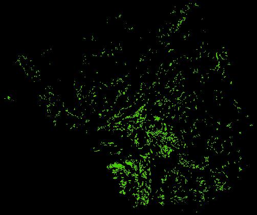
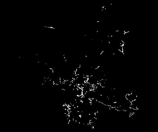
14 Methods Forest Grassland Water area Dry land

15 Methods 1 Predict the change of land use by CLUE-S Aspect raster data Population raster data
16 Methods 2 Simulate the water pollution by SWAT Data Digital elevation model (DEM) (30m) Land use data Data sources National Geomatics Center of China Land use in 2020 was predicted by CLUE-S Land use raster graph of Xiangxi watershed meteorological data Xingshan and Zigui weather bureau Flow and water quality data Yichang Bureau of hydrology and water resources monitoring
17 Methods 3 Put forward control measures based on BMPs BMPs are the efficient measures to control the agriculture non-point source pollution,it has been used in American first. It can be classified into engineering and non-engineer.

18 PART FOUR Results and Discussion
19 Results and Discussion 01.Prediction by CLUE-S 02.Simulation by SWAT Results 03.BMPs 04.Research content in the future


20 Results and Discussion 1 Prediction by CLUE-S
21 Results and Discussion 1 100% 50% 0% 86.46% 4.92% 0.23% 87.38% 4.88% 0.23% Prediction by CLUE-S Distribution and Comparisontable Table of Land Use 0.18% 0.05% 2.02% 6.18% 1.79% 5.67% 森林草地水域城镇旱地水田 2010 年 2020 年
22 Results and Discussion 1 Prediction by CLUE-S Sliding Land use area(ha) proportion proportion area(ha) scale(%) (%) (%) Forest % % -1.05% Grassland % % 0.83% Water area % % 0.00% Urban % % % Dry land % % 13.15% Paddy field % % 8.95%
23 Results and Discussion 2 Prediction by SWAT TN(kg/ha) TP(kg/ha) Variation Rate of change(%) 11.82% 15.34%
24 Results and Discussion 2 Prediction by SWAT

25 Results and Discussion 2 Prediction by SWAT
26 Results and Discussion 3 BMPs Paddy fields and urban area are the main factors which need to be considered by consulting lots of reference.
27 Results and Discussion 3 BMPs Unreasonable fertilization practice is the main factor resulting in water pollution. The excessive use of fertilizer not only did not promote the growth of crops but also put the fertilizer which did not been absorbed into the water. This will cause the phenomenon of Eutrophication.
28 Results and Discussion 3 BMPs So we need to control the use of the chemical fertilizer. Reduce the amount of N and P in the fertilizer. And ecological agriculture need to be developed to realize the circulation of the materials. Then we can control the pollution before it is produced.
29 Results and Discussion 3 BMPs With the development of society and Economy,the speed of urbanization accelerates. Wastewater discharge is the main factor leading to the pollution. And the living places are dispersed so that the pollution can not be controlled uniformly.
30 Results and Discussion 3 BMPs To solve the problem, we need to upgrade the facilities for dealing with the wastewater. To solve the pollution in countryside, we need to develop the ecological agriculture. Such as using clean energy, reusing the materials and so on.
31 Results and Discussion 3 Research content in the future I used CLUE-S model and SWAT model to predict the land use change and simulate the water pollution. According to the results, we can achieve a trend of the water pollution change.
32 Results and Discussion 3 Research content in the future But the pollution data may be different from the real situation because the research was based on the condition that other effect factors are the same from 2010 to 2020 except the land use.
33 Results and Discussion 3 Research content in the future So, in the future, I will consider more in my research. Make the parameters more accurate, and maybe I can take different scenes into consideration.
34 Thank you for listening!
Modelling the impact of land use change on the water balance in the Xiangxi Catchment (Three Gorges Region, China) using SWAT
 using SWAT") Modelling the impact of land use change on the water balance in the Xiangxi Catchment (Three Gorges Region, China) using SWAT K. Bieger, B. Schmalz, Q. Cai, N. Fohrer 2010 International SWAT Conference
Modelling the impact of land use change on the water balance in the Xiangxi Catchment (Three Gorges Region, China) using SWAT K. Bieger, B. Schmalz, Q. Cai, N. Fohrer 2010 International SWAT Conference
Institute of Agricultural Resources and Regional Planning Chinese Academy of Agricultural Sciences(CAAS)
") Institute of Agricultural Resources and Regional Planning Chinese Academy of Agricultural Sciences(CAAS) The Integration of Export Coefficient Method and SWAT Model for Identifying the Contribution of
Institute of Agricultural Resources and Regional Planning Chinese Academy of Agricultural Sciences(CAAS) The Integration of Export Coefficient Method and SWAT Model for Identifying the Contribution of
Contrasting Spatial Distribution of the Emission and Export of Diffuse Nutrient at Watershed Level
 Contrasting Spatial Distribution of the Emission and Export of Diffuse Nutrient at Watershed Level Wenchao Li, Limei Zhai, Qiuliang Lei, Shen Liu, Wanli Hu, Hongbin Liu *, Tianzhi Ren 2016/7/27 Key Laboratory
Detecting Land Use Change in China by Remote Sensing ( )
") Detecting Land Use Change in China by Remote Sensing (1990-2005) Jiyuan Liu Chinese Academy of Sciences Jiaguo Qi, Michigan State University Ailikun, IPO, MAIRS Liqin Shao, MOST, China January, 2009, Thailand
Detecting Land Use Change in China by Remote Sensing (1990-2005) Jiyuan Liu Chinese Academy of Sciences Jiaguo Qi, Michigan State University Ailikun, IPO, MAIRS Liqin Shao, MOST, China January, 2009, Thailand
TEEB Related Research Activities in China an overview. TIAN Yu Chinese Research Academy of Environmental Sciences
 TEEB Related Research Activities in China an overview TIAN Yu Chinese Research Academy of Environmental Sciences Background to assess the overall contribution of ecosystems to social and economic well-being;
Impact of non-point source pollution on water quality of Pengxi River using SWAT model after 175-meter water project operation of the Three Gorges Dam
 Purdue University, USA Impact of non-point source pollution on water quality of Pengxi River using SWAT model after 175-meter water project operation of the Three Gorges Dam Yingyuan Shi, Wanshun Zhang,
Reporter:Xiaoyan Zheng Tutor:Wanshun Zhang From:Wuhan University, Hubei province,in China Date:
 An analysis on the effect of settlements distribution changes to the NPS in the Xiaojiang River Basin after the construction of the Three Gorges Reservoir using SWAT model Reporter:Xiaoyan Zheng Tutor:Wanshun
Comprehensive Watershed Modeling for 12- digit HUC Priority Watersheds Phase II
 Comprehensive Watershed Modeling for 12- digit HUC Priority Watersheds Phase II PRESENTED BY: NARESH PAI PI: Dharmendra Saraswat Collaborator: Mike Daniels OBJECTIVE Project Objective Prioritize 12-digit
Non-point source pollution research trend over three decades. Prof. Dr. Ouyang Wei School of Environment Beijing Normal University
 Non-point source pollution research trend over three decades and possible directions Prof. Dr. Ouyang Wei School of Environment Beijing Normal University wei@bnu.edu.cn Yearly publications web of science
TMDL Data Requirements for Agricultural Watersheds
 This is not a peer-reviewed article. Pp. 408-415 in Total Maximum Daily Load (TMDL) Environmental Regulations: Proceedings of the March 11-13, 2002 Conference, (Fort Worth, Texas, USA) Publication Date
Colorado River Environmental Models
 Colorado River Environmental Models Presented to Mid-Central Water Quality Advisory Committee by Dean Thomas, P.E. LCRA Water Quality Protection January 20, 2015 Presentation Overview What is CREMS? A
Flow and sediment yield simulations for Bukit Merah Reservoir catchment, Malaysia: a case study
 2170 IWA Publishing 2012 Water Science & Technology 66.10 2012 Flow and sediment yield simulations for Bukit Merah Reservoir catchment, Malaysia: a case study Zorkeflee Abu Hasan, Nuramidah Hamidon, Mohd
Impact of Climate Scenarios on Water Resource in River Xiangxi and Huangfuchuan basin
 Impact of Climate Scenarios on Water Resource in River Xiangxi and Huangfuchuan basin Hongmei Xu a, Richard Taylor b, Daniel Kingston b Julian Thompson b, Martin Todd b a: National Climate Center, China
Analysis of Runoff Impact by Land Use Change Scenarios in an Urbanizing Watershed Using SWAT Model
 2012 SWAT International Conference Analysis of Runoff Impact by Land Use Change Scenarios in an Urbanizing Watershed Using SWAT Model July 20, 2012 YU, Young-Seok* Graduate Student KIM, Sang-Ho / LEE,
Effects of land use change on the water resources of the Basoda basin using the SWAT model
 INDIAN INSTITUTE OF TECHNOLOGY ROORKEE Effects of land use change on the water resources of the Basoda basin using the SWAT model By Santosh S. Palmate* 1 (Ph.D. Student) Paul D. Wagner 2 (Postdoctoral
Reducing Nitrogen, Phosphorus and Sediment Pollution Progress Update. Jeff Corbin, Senior Advisor to the EPA Administrator
 Reducing Nitrogen, Phosphorus and Sediment Pollution Progress Update Jeff Corbin, Senior Advisor to the EPA Administrator Reducing Pollution Briefing Package Overview 1. 29-11 Milestones 2. 211 Progress
Understanding Water-Human interaction through an Intelligent Digital Watershed: Initial development and Implementation
 Understanding Water-Human interaction through an Intelligent Digital Watershed: Initial development and Implementation Presented by: Sudipta K. Mishra The Group: Sudipta K. Mishra, Umashanker Rapolu, Deng
THE SIMULATION OF AGRICULTURAL NON- POINT SOURCE POLLUTION IN SHUANGYANG RIVER WATERSHED
 THE SIMULATION OF AGRICULTURAL NON- POINT SOURCE POLLUTION IN SHUANGYANG RIVER WATERSHED Yongsheng Ma 1, Xiucui Tan 1,*, Qiuyue Shi 1 School of Water Conservancy & Civil Engineering, Northeast Agricultural
Application the SWAT model for Extreme Urban Flash Floods in Seoul
 Application the SWAT model for Extreme Urban Flash Floods in Seoul 18 July 2013 International SWAT Conference, Toulouse, France Hyung Kyung Joh / Researcher / Weather Information Service Engine Division
SWAT modeling of Arroyo Colorado watershed
 SWAT modeling of Arroyo Colorado watershed Narayanan Kannan Texas AgriLife Research (Texas A&M University System) Temple Need for the project Arroyo Colorado failed to meet Texas water quality standards
WaterTech 2015 Total Loading Management Plan - An Integrated Watershed Management Approach. Lily Ma, The City of Calgary April, 2015
 WaterTech 2015 Total Loading Management Plan - An Integrated Watershed Management Approach Lily Ma, The City of Calgary April, 2015 Presentation Outline History of City of Calgary s TLMP and BRWQM TLMP
Assessment of StreamFlow Using SWAT Hydrological Model
 Assessment of StreamFlow Using SWAT Hydrological Model Sreelakshmi C.M. 1 Dr.K.Varija 2 1 M.Tech student, Applied Mechanics and Hydraulics, NITK, Surathkal,India 2 Associate Professor, Department of Applied
Study of Hydrology based on Climate Changes Simulation Using SWAT Model At Jatiluhur Reservoir Catchment Area
 Study of Hydrology based on Climate Changes Simulation Using SWAT Model At Jatiluhur Reservoir Catchment Area Budi Darmawan Supatmanto 1, Sri Malahayati Yusuf 2, Florentinus Heru Widodo 1, Tri Handoko
Comparison of three flood runoff models in the Shonai River basin, Japan
 Comparison of three flood runoff models in the Shonai River basin, Japan TOSHIHARU KOJIMA Division of Fluvial and Marine Disasters, Disaster Prevention Research Institute, Kyoto University, Gokasho, Uji,
IMPACT OF HYDROELECTRIC DEVELOPMENT OF THE UPPER REACHES OF IRRAWADDY RIVER ON THE LOWER REACHES
 IMPACT OF HYDROELECTRIC DEVELOPMENT OF THE UPPER REACHES OF IRRAWADDY RIVER ON THE LOWER REACHES Reporter: Ma Jianwei China Institute of Water Resource and Hydropower Research 22 Feb 2018 http://www.iwhr.com/iwhr-english/index.htm
THE SIMULATION OF AGRICULTURAL NON- POINT SOURCE POLLUTION IN SHUANGYANG RIVER WATERSHED
 THE SIMULATION OF AGRICULTURAL NON- POINT SOURCE POLLUTION IN SHUANGYANG RIVER WATERSHED Yongsheng Ma 1, Xiucui Tan 1,*, Qiuyue Shi 1 School of Water Conservancy & Civil Engineering, Northeast Agricultural
Water Data Needs and Applications in the Private Sector. Robert Annear, Vice President, Ph.D., P.E. Water is our nature
 Water Data Needs and Applications in the Private Sector Robert Annear, Vice President, Ph.D., P.E. Water is our nature GRN Forum: Global Water - 2010 and Beyond Oct 21 2010 - Oct 22 2010 Introduction Our
Michalak et al Lake Erie and HABs Dan Warner
 Record-setting algal bloom in Lake Erie caused by agricultural and meteorological trends consistent with expected future conditions Michalak et al. 2013 Lake Erie and HABs Dan Warner Context and History
Application of the SWAT Model to the Hii River Basin, Shimane Prefecture, Japan
 Application of the SWAT Model to the Hii River Basin, Shimane Prefecture, Japan H. Somura, I. Takeda, Y. Mori Shimane University D. Hoffman Blackland Research and Extension Center J. Arnold Grassland Soil
Modeling the production of multiple ecosystems services from agricultural and forest landscape in Rhode Island
 Modeling the production of multiple ecosystems services from agricultural and forest landscape in Rhode Island Tingting Liu a, Nathaniel H. Merrill a, Arthur J. Gold b, Dorothy Q. Kellogg b and Emi Uchida
GIS Framework to Evaluate Impact of Climate Change on Water Resources
 GIS Framework to Evaluate Impact of Climate Change on Water Resources Dr. Nagraj S. Patil A. K. Gosain, Professor Civil Engineering Department I. I. T. Delhi Objectives of the Study To Develop portal to
Comparing Agricultural and Urban Nutrient Loads to Coastal Systems
 Comparing Agricultural and Urban Nutrient Loads to Coastal Systems João Pedro NUNES, João Gomes FERREIRA University of Aveiro, Portugal NOVA University of Lisbon, Portugal Longline Environment, UK Nutrient
Boini Narsimlu, A.K.Gosain and B.R.Chahar
 Boini Narsimlu, A.K.Gosain and B.R.Chahar The water resource of any river basin is basis for the economic growth and social development. High temporal and spatial variability in rainfall, prolonged dry
Modeling Status Update Review of Data and Documents
 SUSTAINABLE, JUST & PRODUCTIVE WATER RESOURCES DEVELOPMENT IN WESTERN NEPAL UNDER CURRENT & FUTURE CONDITIONS (DIGO JAL BIKAS DJB) Modeling Status Update Review of Data and Documents Tuesday, 1 ST August,
Detailed spatial analysis of the plausibility of surface runoff and sediment yields at HRU level in a mountainous watershed in China
 Christian-Albrechts-Universität zu Kiel Institut für Natur- und Ressourcenschutz Detailed spatial analysis of the plausibility of surface runoff and sediment yields at HRU level in a mountainous watershed
Lake of the Pines. Watershed TMDL. Depressed DO conditions in 3,700 acres of upper reservoir; declining
 Lake O O the Pines Watershed TMDL Presented at: 15 th National NPS Monitoring Workshop August 27, 2007 Vernon D. Rowe, P.E. Pilgrim s Pride Corporation Corporate Environmental Manager Lake of the Pines
Discussion of a Decade Accumulative Assessment from Baseline for Future Climate Change Impact on Watershed Hydrology and Water Quality using SWAT
 SESSION I3: ENVIRONMENTAL APPLICATIONS Discussion of a Decade Accumulative Assessment from Baseline for Future Climate Change Impact on Watershed Hydrology and Water Quality using SWAT Ji Wan Lee, Chung
Turbidity Monitoring Under Ice Cover in NYC DEP
 Turbidity Monitoring Under Ice Cover in NYC DEP Reducing equifinality by using spatial wetness information and reducing complexity in the SWAT-Hillslope model Linh Hoang 1,2, Elliot M. Schneiderman 2,
The Fourth Assessment of the Intergovernmental
 Hydrologic Characterization of the Koshi Basin and the Impact of Climate Change Luna Bharati, Pabitra Gurung and Priyantha Jayakody Luna Bharati Pabitra Gurung Priyantha Jayakody Abstract: Assessment of
WATER QUALITY MODEL FOR EL CAJON AND AGUAMILPA RESERVOIRS. Edith G. Lugo. Rushit Hila. Oliver Obregon. Final Report
 WATER QUALITY MODEL FOR EL CAJON AND AGUAMILPA RESERVOIRS by Edith G. Lugo Rushit Hila Oliver Obregon Final Report Mexico-Engineering Study Abroad 2008 Department of Civil and Environmental Engineering
RUNOFF PROPERTIES OF THE AMUR RIVER AND
 RUNOFF PROPERTIES OF THE AMUR RIVER AND THE CONSTRUCTION OF THE HYDROLOGICAL MODEL INCORPORATING DISSOLVED IRON TRANSPORT ONISHI TAKEO Research Institute for Humanity and Nature INTRODUCTION The Amur River
Estimation of transported pollutant load in Ardila catchment using the SWAT model
 June 15-17 Estimation of transported pollutant load in Ardila catchment using the SWAT model 1 Engineering Department Polytechnic Institute of Beja 2 Section of Environmental and Energy Technical University
4. Indicator number / code: 4
 Metadata Sheet Template Title: Indicator Number: Cluster: Rationale: Nutrient Pollution. 4. Indicator number / code: 4 Water Quality River nutrient pollution is caused mainly by agricultural activities
A comparison study of multi-gage and single-gage calibration of the SWAT model for runoff simulation in Qingjiang river basin
 A comparison study of multi-gage and single-gage calibration of the SWAT model for runoff simulation in Qingjiang river basin Dan YU, Xiaohua DONG, Lei LI, Sanhong SONG, Zhixiang LV and Ji LIU China Three
Lake Prespa Restoration Programme Challenges, Strategy and Achievements
 Lake Prespa Restoration Programme Challenges, Strategy and Achievements Source: SPP Prespa an ecosystem of global significance that has been facing with serious environmental challenges over the past decades
Evaluating the Reduction Effect of Nonpoint Source Pollution Loads from Upland Crop Areas by Rice Straw Covering Using SWAT
 SESSION J2 : Water Resources Applications - I New Delhi, India 2012 International SWAT Conference Evaluating the Reduction Effect of Nonpoint Source Pollution Loads from Upland Crop Areas by Rice Straw
Models Overview: Purposes and Limitations
 Models Overview: Purposes and Limitations Pollutant load originates from: Point-source discharges (NPDES facilities) Info is available on the discharges (DMRs, etc.) Some are steady-flow, others are precip-driven
August 6, Min-Ji Park, Hyung-Jin Shin, Jong-Yoon Park Graduate Student. Geun-Ae Park. Seong-Joon Kim
 Comparison of Watershed Streamflow by Using the Projected MIROC3.2hires GCM Data and the Observed Weather Data for the Period of 2000-2009 under SWAT Simulation August 6, 2010 Min-Ji Park, Hyung-Jin Shin,
Isfahan University of Technology. Soil erosion hazard prediction by SWAT model and fuzzy logic in a highly mountainous watershed
 Isfahan University of Technology Soil erosion hazard prediction by SWAT model and fuzzy logic in a highly mountainous watershed Introduction Challenges Soil erosion A major environmental threat to the
Weeks Bay Stakeholder Work Group Baldwin County Highway Department 3 rd Floor CR 8:30 10:00 am May 18, 2016 AGENDA
 Weeks Bay Stakeholder Work Group Baldwin County Highway Department 3 rd Floor CR 8:30 10:00 am May 18, 2016 AGENDA 1. Approve minutes of March 16, 2016 SWG Meeting 2. Opening remarks 3. Online survey results
Modeling the Impacts of Agricultural Conservation Strategies on Water Quality in the Des Moines Watershed
 Modeling the Impacts of Agricultural Conservation Strategies on Water Quality in the Des Moines Watershed Presenter: Jeff Arnold, Supervisory Research Engineer, USDA-ARS C. Santhi, M. White, M. Di Luzio
Water Quality Assessment in the Thames River Watershed
 Water Quality Assessment in the Thames River Watershed Nutrient Trends Karen Maaskant, Upper Thames River Conservation Authority 2015 Lake St. Clair Conference October 21, 2015 Outline Thames River watershed,
Physically-based Watershed Health, Resilience, and Priority Assessment of the Han River Basin in South Korea
 2016 International SWAT Conference July 27-29, 2016, Beijing, China SESSION A2: ENVIRONMENTAL APPLICATIONS Meeting Room No.2 2016 International SWAT Conference Physically-based Watershed Health, Resilience,
Impact analysis of the decline of agricultural land-use on flood risk and material flux in hilly and mountainous watersheds
 Proc. IAHS, 370, 39 44, 2015 doi:10.5194/piahs-370-39-2015 Author(s) 2015. CC Attribution 3.0 License. Impact analysis of the decline of agricultural land-use on flood risk and material flux in hilly and
Impact of Climate and Landuse Change on the Hydrology and Water Quality of Major River Basins in the United States
 Impact of Climate and Landuse Change on the Hydrology and Water Quality of Major River Basins in the United States Debjani Deb 1, Pushpa Tuppad 2, Raghavan Srinivasan 1 1 Texas Agrilife Research, Texas
Hydrological And Water Quality Modeling For Alternative Scenarios In A Semi-arid Catchment
 Hydrological And Water Quality Modeling For Alternative Scenarios In A Semi-arid Catchment AZIZ ABOUABDILLAH, ANTONIO LO PORTO METIER Final Conference: Brussels, Belgium-4-6 November 2009 Outline Problem
SAN BERNARD RIVER WATER QUALITY MODEL UPDATE. August 18, 2011
 SAN BERNARD RIVER WATER QUALITY MODEL UPDATE August 18, 2011 Agenda Model Set-up Watershed model Watershed delineations Generate model input files & establish coefficients Receiving Water model Establish
IMPACT OF LAND USE/COVER CHANGES ON STREAMFLOW:
 IMPACT OF LAND USE/COVER CHANGES ON STREAMFLOW: THE CASE OF HARE RIVER WATERSHED, ETHIOPIA Kassa Tadele and Gerd Foerch University of Siegen July 06, 2007 Presentation outline 1. Introduction Study area
Land Use Change Effects on Discharge and Sediment Yield of Song Cau Catchment in Northern Vietnam
 NPUST 2010 INTERNATIONAL SWAT CONFERENCE August 4-6 th, 2010 MAYFIELD HOTEL, SEOUL, KOREA Land Use Change Effects on Discharge and Sediment Yield of Song Cau Catchment in Northern Vietnam Phan Dinh Binh
R. Srinivasan, J.H. Jacobs, J.W. Stuth, J. Angerer, R. Kaithio and N. Clarke
 Impacts of reforestation policy and agro-forestry technology on the environment and food security in the Upper Tana river basin of Kenya R. Srinivasan, J.H. Jacobs, J.W. Stuth, J. Angerer, R. Kaithio and
Assessment of Water Resources Carrying Capacity: A Case Study of Zhangye in China
 Assessment of Water Resources Carrying Capacity: A Case Study of Zhangye in China ZHU YIZHONG School of politics and public administration South China University of Technology 381 Wushan Road, Guangzhou,
1Water Resources Department, Faculty of Engineering, University of Brawijaya, East Java, Indonesia;
 Advanced Materials Research Vols. 250-253 (2011) pp 3945-3948 Online available since 2011iMayl17 at www.scientific.net (201 J) Trans Tech Publications, Switzerland doi: 10.4028Iwww.scientijic.netIAMR.250-253.
Objectives of the Study
 Integration of AGNPS, GIS, and Remote Sensing for Estimating Nonpoint Source Pollution in the Saginaw Bay, Michigan Chansheng He Department of Geograophy Western Michigan University Kalamazoo, MI 49008
Impacts of Climate Change on Nitrogen Load and its Control in the Upper Huai River Basin, China
 Impacts of Climate Change on Nitrogen Load and its Control in the Upper Huai River Basin, China Xiaoying Yang xiaoying@fudan.edu.cn Department of Environmental Science & Engineering, Fudan University,
Model objectives. Main features. Water Evaluation And Planning (WEAP)
") Water Evaluation And Planning (WEAP) Model objectives WEAP ( Water Evaluation And Planning system) is a userfriendly software tool that fully integrates water supply, demand, water quality and ecological
Water Evaluation And Planning (WEAP) Model objectives WEAP ( Water Evaluation And Planning system) is a userfriendly software tool that fully integrates water supply, demand, water quality and ecological
Water Quality Impacts of Agricultural BMPs in a Suburban Watershed in New Jersey
 Water Quality Impacts of Agricultural BMPs in a Suburban Watershed in New Jersey Zeyuan Qiu Lizhong Wang Department of Chemistry and Environmental Science New Jersey Institute of Technology Newark, NJ
GreenPlan Modeling Tool User Guidance
 GreenPlan Modeling Tool User Guidance Prepared by SAN FRANCISCO ESTUARY INSTITUTE 4911 Central Avenue, Richmond, CA 94804 Phone: 510-746-7334 (SFEI) Fax: 510-746-7300 www.sfei.org Table of Contents 1.
TA-8267 THA: STRENGTHENING INTEGRATED WATER AND FLOOD MANAGEMENT IMPLEMENTATION
 TA-8267 THA: STRENGTHENING INTEGRATED WATER AND FLOOD MANAGEMENT IMPLEMENTATION Mae Ta Sub-basin IWRM Modelling Results Report March 2015 Prepared for ADB Prepared by Prepared for Copyright Suggested citation
Water Resources Element Appendix
 Appendix Housing Unit Projection Methodology The following assumptions were used to develop the housing unit projections for each Water Resources Element. All projections described in the and this Appendix
Assessment of Watershed Soundness by Water Balance Using SWAT Model for Han River Basin, South Korea
 2015 International SWAT Conference & Workshops October 12-16, 2015 Purdue University, USA SESSION A3: HYDROLOGY Room: Stewart 278 2015 International SWAT Conference Assessment of Watershed Soundness by
Inside of forest (for example) Research Flow
 Research Flow") Study on Relationship between Watershed Hydrology and Lake Water Environment by the Soil and Water Assessment Tool (SWAT) Shimane University Hiroaki SOMURA Watershed degradation + Global warming Background
Study on Relationship between Watershed Hydrology and Lake Water Environment by the Soil and Water Assessment Tool (SWAT) Shimane University Hiroaki SOMURA Watershed degradation + Global warming Background
Application of SWAT Model in land-use. change in the Nile River Basin: A Review
 Application of SWAT Model in land-use change in the Nile River Basin: A Review By: Marwa Ali, Okke Batelaan and Willy Bauwens 15-6-2011 Application of SWAT Model in land-use 1 change in the Nile River
Nitrate Load Reduction Strategies for the Raccoon and Des Moines Rivers. Keith Schilling, Calvin Wolter Iowa DNR Geological and Water Survey
 Nitrate Load Reduction Strategies for the Raccoon and Des Moines Rivers Keith Schilling, Calvin Wolter Iowa DNR Geological and Water Survey Outline of Presentation Background of nitrate impairments Nitrate
Modeling Sediment and Nutrient Loads Input to Chesapeake Bay and Effects of Agricultural Conservation Practices on Water Quality
 Modeling Sediment and Nutrient Loads Input to Chesapeake Bay and Effects of Agricultural Conservation Practices on Water Quality C. Santhi and CEAP National Assessment Team Texas A&M University System,
Combining a Conceptual Hydrologic Model (SWAT) and a Hydrodynamic Model (Telemac 3D) to Simulate Reservoir Dynamics in. Eagle Creek Reservoir, Indiana
 and a Hydrodynamic Model (Telemac 3D) to Simulate Reservoir Dynamics in. Eagle Creek Reservoir, Indiana") Combining a Conceptual Hydrologic Model (SWAT) and a Hydrodynamic Model (Telemac 3D) to Simulate Reservoir Dynamics in Eagle Creek Reservoir, Indiana 1 Purpose of Modeling Effort Fate and Transport of
Combining a Conceptual Hydrologic Model (SWAT) and a Hydrodynamic Model (Telemac 3D) to Simulate Reservoir Dynamics in Eagle Creek Reservoir, Indiana 1 Purpose of Modeling Effort Fate and Transport of
Regional Seminar on SWAT, SANREM Book Launch and SWAT Workshop, Bogor, Indonesia (SWAT School of Bogor) June 27-29, 2012
 June 27-29, 2012") Regional Seminar on SWAT, SANREM Book Launch and SWAT Workshop, Bogor, Indonesia (SWAT School of Bogor) June 27-29, 2012 Introduction Objectives SWAT application Results Acknowledgements 2 Bi Doup - Núi
Regional Seminar on SWAT, SANREM Book Launch and SWAT Workshop, Bogor, Indonesia (SWAT School of Bogor) June 27-29, 2012 Introduction Objectives SWAT application Results Acknowledgements 2 Bi Doup - Núi
Eutrophication Control and Coordinated Development of Society-Economy-Environment
 Eutrophication Control and Coordinated Development of Society-Economy-Environment Li Meng Institute for Urban and Environmental Studies Chinese Academy of Social Sciences 27-2-2012 Oslo,Norway Contents
Joint Research Centre (JRC)
") Joint Research Centre (JRC) Marco Pastori and Faycal Bouraoui IES - Institute for Environment and Sustainability Ispra - Italy http://ies.jrc.ec.europa.eu/ http://www.jrc.ec.europa.eu/ CONTENT Introduction
Joint Research Centre (JRC) Marco Pastori and Faycal Bouraoui IES - Institute for Environment and Sustainability Ispra - Italy http://ies.jrc.ec.europa.eu/ http://www.jrc.ec.europa.eu/ CONTENT Introduction
Analyzing water resources in a monsoon-driven environment an example from the Indian Western Ghats
 Analyzing water resources in a monsoon-driven environment an example from the Indian Western Ghats 1, Shamita Kumar 2, Peter Fiener 1 and Karl Schneider 1 1,,, Germany 2 Institute of Environment Education
Development of an Intelligent Digital Watershed for sustainable Agro economy in the US Midwest
 Development of an Intelligent Digital Watershed for sustainable Agro economy in the US Midwest Presented by: Sudipta K Mishra Group members: Sudipta K. Mishra, Deng Ding, Umashanker Rapolu, Nicholas J
The Relationship of Agriculture, Water and the Environment
 The Relationship of Agriculture, Water and the Environment Marcia Fox DNREC, Division of Watershed Stewardship, Nonpoint Source Program Delaware s Watersheds Piedmont Delaware Basin Chesapeake Basin Inland
International Journal of Scientific & Engineering Research, Volume 5, Issue 7, July-2014 ISSN Sruthy Nattuvetty Manoharan
 ISSN 2229-5518 210 Sruthy Nattuvetty Manoharan Department of Civil Engineering Government Engineering College, Thrissur Thrissur, 680009 sruthy.n.m@gmail.com a spatially distributed excess rainfall. It
ESTIMATION OF WATER RESOURCES LOADING INTO THE DAM RESERVOIR. Cindy J. Supit ABSTRACT
 ESTIMATION OF WATER RESOURCES LOADING INTO THE DAM RESERVOIR Cindy J. Supit ABSTRACT Estimation of water resources loading into the dam reservoir is an important study that will provide a new approach
Application of the PRMS model in the Zhenjiangguan watershed in the Upper Minjiang River basin
 doi:10.5194/piahs-368-209-2015 Remote Sensing and GIS for Hydrology and Water Resources (IAHS Publ. 368, 2015) (Proceedings RSHS14 and ICGRHWE14, Guangzhou, China, August 2014). 209 Application of the
Assessing the Hydrological Impacts of Grain for Green " Policy in the Loess Plateau of Northern China
 Assessing the Hydrological Impacts of Grain for Green " Policy in the Loess Plateau of Northern China Chansheng He 1,2, Bojie Fu 3, Yanda Xu 3, Lanhui Zhang 1 1 Research School of Arid Environment and
Evaluation of land use, land management and soil conservation strategies to reduce non-point source pollution loads in the Three Gorges Region, China
 Photo: A. Strehmel Christian-Albrechts-University, Kiel Institute for Natural Resources Conservation Evaluation of land use, land management and soil conservation strategies to reduce non-point source
Analysis of Future Discharge in Nakdong River Basin According to Effect on Climate Change
 Hydrology Days 2012 Analysis of Future Discharge in Nakdong River Basin According to Effect on Climate Change Hyun Suk Shin 1, Mi Eun Kim 2, Ji Ye Im, and Tae Seok Shon 3 Department of Civil and Environmental
Hydrological Impact of Large Scale Conversion of Rubber to Oil Palm Plantation
 2014 International SWAT Conference Pernambuco, Brazil [July 30 - August 1, 2014] Mature rubber Oil palm Hydrological Impact of Large Scale Conversion of Rubber to Oil Palm Plantation Source: Google earth
Setting the Course for Improved Water Quality: Modeling for TMDL Studies
 Setting the Course for Improved Water Quality: Modeling for TMDL Studies A TMDL training program for local government leaders and other water managers Session 11a wq-iw3-61a Presentation goals Define the
Assessment of Changes in Hydrologic Regime of the Teesta River by Teesta V Hydroelectric Power Project in Sikkim India
 Assessment of Changes in Hydrologic Regime of the Teesta River by Teesta V Hydroelectric Power Project in Sikkim India Kausila Timsina Department of Geography Sikkim University INTRODUCTION Dams as monuments
2013 SWAT CONFERENCE Toulouse, France, July 17-19, 2013
 7/19/2013 2013 SWAT CONFERENCE Toulouse, France, July 17-19, 2013 Nguyen Kim Loi (1), Nguyen Duy Liem (1), Pham Cong Thien (1), Le Van Phan (1), Le Hoang Tu (1), Hoang Thi Thuy (1), Nguyen Van Trai (1),
Linear Programming Applications. Structural & Water Resources Problems
 Linear Programming Applications Structural & Water Resources Problems 1 Introduction LP has been applied to formulate and solve several types of problems in engineering field LP finds many applications
EUTROPHICATION. Student Lab Workbook
 EUTROPHICATION Student Lab Workbook THE SCIENTIFIC METHOD 1. Research Background literature research about a topic of interest 2. Identification of a problem Determine a problem (with regards to the topic)
Parameter Calibration of SWAT Hydrology and Water Quality Focusing on Long-term Drought Periods
 2017 SWAT June 28-30, 2017 Centrum Wodne SGGW, Warsaw, Poland Theme I3 Environmental Applications Room: Assembly Hall 2 2017 International SWAT Conference Parameter Calibration of SWAT Hydrology and Water
Adapting reservoir management strategies to climate change in Alentejo
 AdaPT Program presentation 16/09/2015 Adapting reservoir management strategies to climate change in Alentejo Paulo Diogo, Pedro Beça OUTLINE Project s motivation Main objectives and tasks Study area Relevance
University of Milan Department of Agricultural and Environmental Sciences Production, Landscape, Agroenergy
 University of Milan Department of Agricultural and Environmental Sciences Production, Landscape, Agroenergy Integrated Information and Communication Tools and Technologies for Managing Natural Resources:
Site Selection for Nuclear Power Plants in China. Du Fenglei, Shanghai Nuclear Engineering Research and Design Institute July 7th,2010
 Site Selection for Nuclear Power Plants in China Du Fenglei, Shanghai Nuclear Engineering Research and Design Institute July 7th,2010 About SNERDI Established in February of 1970, the Shanghai Nuclear
Water Quality Index Assessment for the Skudai Watershed and its Tributaries
 Water Quality Index Assessment for the Skudai Watershed and its Tributaries Irena Naubi 1, Noorul Hassan Zardari 2, *, Sharif Moniruzzaman Shirazi 2, Shazwin Binti Mat Taib 2 1 Department of Hydraulics
2
 1 2 3 4 5 6 The program is designed for surface water hydrology simulation. It includes components for representing precipitation, evaporation, and snowmelt; the atmospheric conditions over a watershed.