Rags to Riches - The RVCA Story of Science to Stewardship
|
|
|
- Nathan Watson
- 6 years ago
- Views:
Transcription
1 Rags to Riches - The RVCA Story of Science to Stewardship


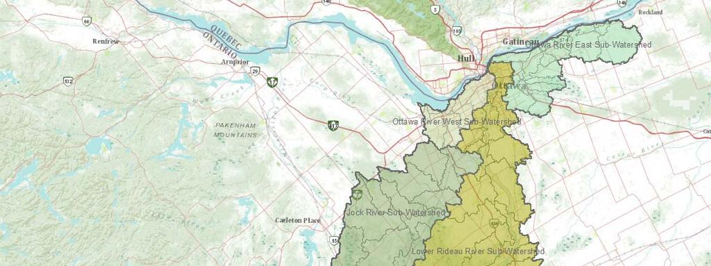
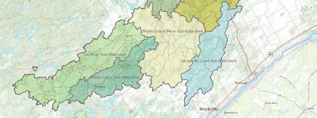
2 Rideau Valley Conservation Authority Eastern Ontario On Shield off Shield Large Urban population (Ottawa) Rideau Canal connecting St Lawrence to Ottawa River
3 Monitor Act Engage Analyze Report
4 Monitoring Programs Monitoring Programs
5 Watershed Science Engineering Services Watershed Reports plans Surface Water Quality Hydrometric Monitoring Forecasting Groundwater Aquatic Terrestrial Habitat Watershed Information Management System Water Control Infrastructure Operations Flood, Erosion Drought Studies
6 Surface Water Quality Provincial Water Quality Monitoring Network (PWQMN) Baseline Water Quality Monitoring Watershed Watch
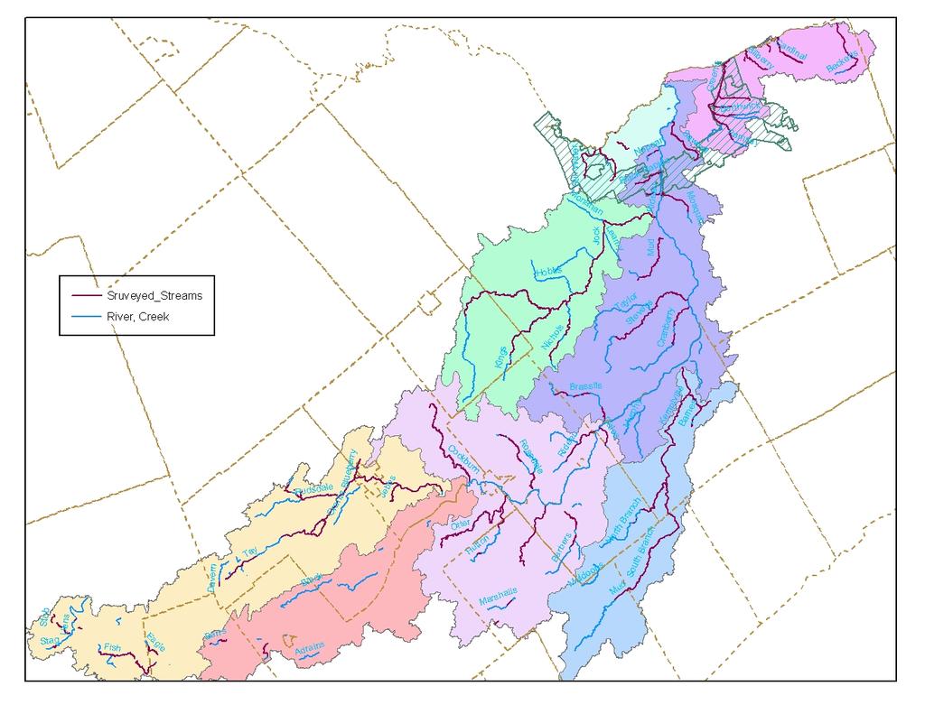
 Tay River (2) Data set from 1964 present Numerous parameters including chloride, nutrients")
7 PWQMN Partner in provincial network 10 sites monitored monthly from April November Rideau River (6) Jock River (1) Kemptville Creek (1) Tay River (2) Data set from 1964 present Numerous parameters including chloride, nutrients metals

8 Baseline Water Quality Monitoring Network of streams sites follows methodology timing to PWMQN 1998 to present Objectives: To assess the contributions of tributary streams to the Rideau River upper watershed lakes To monitor ambient conditions at locations on major tributary streams
 Sampled over 3 consecutive days in three")
9 Baseline Water Quality 56 sites monitored for 40 variables (bacteria, nutrients, dissolved solids, cations/anions, field measurements) 21 at or near the mouth of small tributaries 35 sites on major tributaries (Kemptville Creek Tay River) Sampled over 3 consecutive days in three runs

10 Watershed Watch Network that monitors 39 lakes throughout watershed Deep points Shoreline sites at possible pollution sources reference sites


11 Watershed Watch Objectives: Intensively sample watershed lakes on a regular cycle to help identify trends in water quality Partnership with Ontario Federation of Hunters Anglers determine the spread distribution of invasive species Sample methodology Deep point Composite sample from euphotic zone Deep water taken 1m above bottom Dissolved oxygen/temperature profile at 1m intervals Plankton net tow Shoreline sites Grab sample at 0.5 m in 1 m depth of water Record water chemistry site characteristics
12 Watershed Science Engineering Services Watershed Reports plans Surface Water Quality Hydrometric Monitoring Forecasting Groundwater Aquatic Terrestrial Habitat Watershed Information Management System Water Control Infrastructure Operations Flood, Erosion Drought Studies

13 Hydrometric Monitoring
14 Hydrometric Monitoring RVCA Hydrometric Activities RVCA benefits from having access to 15 streamgauge stations in the watershed owned /or operated by others (Water Survey, MNRF, Parks Canada) that provide realtime data which we use for drought flood analyses. We also use data from Environment Canada climate stations in those analyses. Parks Canada has heated tipping bucket precipitation gauges on four of their streamgauge stations which piggyback on the telemetry at those stations. RVCA uses the data to supplement that from EC climate sites. RVCA has six precipitation monitoring sites in field locations in the upper half of the Rideau watershed equipped with heated tipping bucket gauges. Installation of telemetry is pending the data will be used as mentioned in the previous point. Data from fifteen Provincial Groundwater Monitoring Network stations several nearby in neighbouring watersheds are beginning to be used in drought analyses. Twenty Onset Hobo pressure transducer loggers have been deployed in streams lakes throughout the watershed recording water levels water temperatures. The intention is that the data will be accumulated for an extended period (>10 years) to be used to characterize the variations that occur in each of these waterbodies for both biological hydrological analyses.
15 Watershed Science Engineering Services Watershed Reports plans Surface Water Quality Hydrometric Monitoring Forecasting Groundwater Aquatic Terrestrial Habitat Watershed Information Management System Water Control Infrastructure Operations Flood, Erosion Drought Studies

16 Partner in the Provincial Groundwater Monitoring Network (PGMN) 13 sites monitored annually Exploring better in house uses for data in the future Valuable ground water information is also provided thought aquatic habitat monitoring programs Thermal Classification Stream Characterization Headwater Drainage Features Groundwater
17 Watershed Science Engineering Services Watershed Reports plans Surface Water Quality Hydrometric Monitoring Forecasting Groundwater Aquatic Terrestrial Habitat Watershed Information Management System Water Control Infrastructure Operations Flood, Erosion Drought Studies
18 Aquatic Monitoring Programs Aquatic Monitoring Programs Stream Characterization Stream Characterization City Stream Watch City Stream Watch Thermal Regime Classification Thermal Regime Classification Municipal Drain Classification Municipal Drain Classification Ontario Benthos Biomonitoing Program Ontario Benthos Biomonitoing Program Headwater Monitoring Headwater Monitoring Biocriteria Program Biocriteria Program Beaver Dam Monitoring Beaver Dam Monitoring
.")


19 Stream Characterization Goal: to collect information on the physical biological attributes of surveyed streams (habitat surveys, fish sampling, thermal regime). Surveys 100 meter sections from the headwaters of the watercourse to where it empties into the lower system Luse along both banks Anthropogenic alterations Instream morphology (type, flow, habitat features, substrate, etc) Instream vegetation type abundance Bank Erosion, steepness vegetation soil composition, etc Agricultural impacts, pollution observations, invasive species presence

 have been completed in the Jock River, Tay")

20 Stream Characterization Fish community structure is assessed using various collection methods (seine nets, windemere trap, elecotrofishing, hoop fyke nets) along the system at different times of year 3427 stream surveys (100 meter intervals) have been completed in the Jock River, Tay River, Kemptville Creek, Middle Rideau, Rideau Lakes Watersheds. Thermal regime is assessed using temperature probes at multiple locations along the system


 have been completed on 25")
21 City Stream Watch Goal: to obtain, record, manage valuable information on the physical biological characteristics of creeks streams in the City of Ottawa, while ensuring that they are respected valued natural features of the communities through which they flow Relies on encourages the interest commitment of volunteers from the community, guided by an experienced coordinator Follows same protocol as stream characterization 1668 stream surveys (100 meter intervals) have been completed on 25 creeks in the City of Ottawa
22 SM1
23 Slide 22 SM1 Can be taken out if too dated Sarah Macleod, 11/6/2014


24 Thermal Regime Classification Goal: to underst the thermal classification for various streams creeks in the Rideau Valley watershed. Temperature probes are installed at various locations along a watercourse. Water temperature maximum air temperature (Stoneman Jones method) used to classify a watercourse as either warm water, cool water or cold water. The data collected is used to report on thermal regime for each system in the RVCA catchment reports. A total of 200 thermal sampling sites have been sampled across the RVCA watershed.


25 Municipal Drain Classification Program The Municipal Drain Classification (MDC) System was developed by DFO, Conservation Authorities other partners to strike a balance between the requirements of the Federal Fisheries Act the Provincial Drainage Act by streamlining the review approval process related to impacts of drain maintenance activities on fish habitat. There are six drain types that result from the assessment (Type A, B, C, D, E, F) each type has varying sensitivities with respect to drain maintenance work. Assessment of: flow type, temperature, fish species, aquatic habitat conditions. RVCA has a total of 415 municipal drains across the watershed
 48 stream sites in the spring fall 2 lake sites in the")

26 Ontario Benthos Biomonitoring Network Goal: to determine water quality habitat quality using a biological method which compliments water chemistry sampling programs, the OBBN protocol samples bottom dwelling bugs (benthic invertebrates) 48 stream sites in the spring fall 2 lake sites in the spring Sampling is done using a stard kick sweep method with a D net Three replicates are collected at each sample location; they are preserved brought back to the lab for identification Samples identified to the family level several indices are run to assess water quality overall aquatic habitat health
")
27 Headwater Monitoring Protocol Goal: to provide stard datasets to support science development monitoring for headwater drainage features RVCA is working with TRCA MNR to develop implement the protocol which measures zero first order headwater drainage features A rapid assessment method characterizing the amount of water, sediment transport, storage capacity within headwater drainage features (HDF) This protocol also characterizes the connectivity, form, unique features associated with the HDF 600 sites sampled by RVCA staff from


28 Headwater Monitoring Field Work Sites are sampled at road crossings Various parameters are measured including the following: Flow measurements upstream downstream of the water crossing Feature type (natural, wetl, channelized, braided, buried, swale, roadside ditch, on line pond, etc) Sediment transport volume Riparian vegetation Site features (nutrient sources u/s, point non point u/s, channel hardening, barriers/dams, springs/seeps, dredging of channel, evidence of channel scouring/erosion, etc)

 the Ontario Benthos Bio Monitoring Network (OBBN) are used All SAR mussels, fish invertebrates are inventoried at each sample location.")
29 Eastern Region Biocriteria Program Goal: to increase knowledge awareness of aquatic species at risk (SAR) throughout South Eastern Ontario Collaboration with South Nation Conservation, City of Ottawa, Rideau Valley Conservation, Mississippi Valley Conservation, Cataraqui Region Conservation, Quinte Conservation, Ontario Ministry of Environment Climate Change Stream surveys are conducted at minimally impacted sites across each partners respective watershed. Ontario Stream Assessment Protocol (OSAP) the Ontario Benthos Bio Monitoring Network (OBBN) are used All SAR mussels, fish invertebrates are inventoried at each sample location. Water quality parameters measured at each site: ph, total phosphorus, nitrates, alkalinity metals.


30 Beaver Dam Monitoring Program Since 2003, each year at the request of member municipalities Survey records beaver dam characteristics: width, height, amount of water being held back, age, materials used to build the dam, breached, submerged, UTM, photos looking upstream, downstream, a cross section of the dam Creation of a database to log lowner flooding concerns as a result of beaver activity Trapping program to remove dam building nuisance beaver Beaver dam removal/breaching that balances flooding concerns aquatic ecosystem needs Stewardship services biology staff work together to determine which beaver dams require trapping removal work


31 How information is used RVCA Watershed Report Cards Catchment reports Internal reports e.g. Haggart Isl Dam Aquatic Habitat Existing Conditions Technical Memo RVCA Planning Regulations Review RVCA Stewardship Services e.g. Science to Stewardship targeting Non Government Agencies e.g. Otty Lake Management Plan External Agencies/Consultants e.g. Cardinal Creek Sub Watershed Study Academics e.g. Relationships between non point source pollution, l use water quality in the Kemptville Creek Subwatershed
Rags to Riches - The RVCA Story of Science to Stewardship. Subwatershed Reporting
 Rags to Riches - The RVCA Story of Science to Stewardship Subwatershed Reporting Monitor Act and Engage Analyze Report Subwatershed Reporting Overview Content of reports Users Monitor Act and Engage Analyze
Headwater Drainage Features
 Headwater Drainage Features Their Natural Functions and an Interim Guideline for their Evaluation, Classification and Management Susan Jorgenson (CVC) & Laura Del Giudice (TRCA) Urban development within
MURPHY DRAIN CATCHMENT
 The RVCA produces individual reports for 16 catchments in the Lower Rideau subwatershed. Using data collected and analysed by the RVCA through its watershed monitoring and land cover classification programs,
Otonabee Region WATERSHED
 Otonabee Region WATERSHED Report Card 2018 Otonabee Conservation has prepared this report card as a summary of the state of your forests, wetlands, and water resources using data from 2012 to 2016. WHERE
Maitland Valley WATERSHED
 Maitland Valley WATERSHED Report Card 2018 Maitland Conservation has prepared this report card as a summary of the state of your forests, wetlands, and water resources. WHERE ARE WE? We are one of 36 Conservation
June 2008 LYNDE CREEK WATERSHED EXISTING CONDITIONS REPORT CHAPTER 10 - WATER TEMPERATURE
 June 2008 LYNDE CREEK WATERSHED EXISTING CONDITIONS REPORT CHAPTER 10 - WATER TEMPERATURE TABLE OF CONTENTS 1.0 INTRODUCTION...3 2.0 STUDY AREA AND SCOPE...5 3.0 METHODOLOGY...7 4.0 FINDINGS...7 4.1 Lynde
Carp Creek 2013 Summary Report
 Monitoring Activity in the Carp River Watershed In 2012, Mississippi Valley Conservation Authority (MVCA) worked with Friends of the Carp River (FCR) on a preliminary assessment of the Carp River. This
WATERSHED. Maitland Valley. Report Card 201
 Maitland Valley WATERSHED Report Card 201 The Maitland Valley Conservation Authority has prepared this report card as a summary on the state of our forests, wetlands, surface water, and ground water resources.
Conservation Authority Watershed Report Cards and the Chesapeake Bay Experience. December 2, 2013 SOSMART
 Conservation Authority Watershed Report Cards and the Chesapeake Bay Experience December 2, 2013 SOSMART Overview of Conservation Authority Watershed Report Cards Series launched March 18, 2013 to celebrate
White Lake 2017 Water Quality Report
 Introduction Watersheds Canada believes that every person has the right to access clean and healthy lakes and rivers in Canada. We work to keep these precious places naturally clean and healthy for people
WELCOME. Eastern Subwatersheds Stormwater Management Retrofit Study. Online Information Session #2 June 15 to July 13, 2018
 WELCOME Eastern Subwatersheds Stormwater Management Retrofit Study Online Information Session #2 June 15 to July 13, 2018 1 Eastern Subwatersheds Stormwater Management Retrofit Study This study is one
Introduction. Mandate
 Page 1 of 11 Introduction This report is intended to provide guidance in establishing a range of priority actions for MVCA to fulfill its mandate and responsibilities as it addresses the emerging challenges
Conservation Ontario s Response to Climate Ready: Ontario s Adaptation Strategy and Action Plan June 2011
 Introduction Conservation Ontario s Response to Climate Ready: Ontario s Adaptation Strategy and Action Plan June 2011 C onservation Ontario is the network of 36 Conservation Authorities, local watershed
APPENDIX G METHODOLOGY FOR EVALUATING RETROFIT OPTIONS/RETROFIT STUDIES
 APPENDIX G METHODOLOGY FOR EVALUATING RETROFIT OPTIONS/RETROFIT STUDIES G.1 Introduction Retrofitting of existing infrastructure may be required to achieve water balance, water quantity, water quality,
Stream Health. Stream Bugs Our Stream Health Communicators. Upper Nottawasaga River Stream Health. NVCA Science & Stewardship
 NVCA Science & Stewardship Stream Health Upper Nottawasaga River, 2015 Stream Bugs Our Stream Health Communicators Stream bugs (benthic macroinvertebrates) are organisms that spend much or all of their
ADDRESSING CLIMATE CHANGE ADAPTATION IN EASTERN ONTARIO APRIL 15, 2013
 ADDRESSING CLIMATE CHANGE ADAPTATION IN EASTERN ONTARIO APRIL 15, 2013 IPCC DEFINITION UNFCCC DEFINITION Climate change in Intergovernmental Panel on Climate Change (IPCC) usage refers to a change in the
Climate Change: Impacts, Monitoring, and Solutions
 Climate Change: Impacts, Monitoring, and Solutions 1 Responding to Climate Change 1. Projections/Impacts 2. Adaptation and Resiliency 3. Monitoring 4. What about emissions? 2 Native trout and salmon are
Species at Risk Act 2016
 Species at Risk Act Recovery Strategy Report Series Report on the Progress of Recovery Strategy Implementation for the Gravel Chub (Erimystax x- punctatus) in Canada for the Period 2008 2015 Gravel Chub
Lake Management Planning in the Rideau Valley Watershed
 Lake Management Planning in the Rideau Valley Watershed Forum National Sur les Lacs June 5, 2008 Lynn Preston Watershed Planning Co-ordinator ordinator Conservation Authorities in Ontario 36 in Ontario
Jan Moryk, Project Manager, Environmental Monitoring and Data Management Section, TRCA
 Distribution of Brook Trout in the TRCA Jurisdiction and what Legislation, Policies, and Guidelines do Conservation Authorities have at their disposal to Protect Brook Trout Habitat Jan Moryk, Project
Jan Moryk, Project Manager, Environmental Monitoring and Data Management Section, TRCA
 Distribution of Brook Trout in the TRCA Jurisdiction and what Legislation, Policies, and Guidelines do Conservation Authorities have at their disposal to Protect Brook Trout Habitat Jan Moryk, Project
Cannon River One Watershed, One Plan. POLICY COMMITTEE MEETING January 10, 2018 Rice County Government Center Faribault, MN
 Cannon River One, One Plan POLICY COMMITTEE MEETING January 10, 2018 Rice County Government Center Faribault, MN TASK Task 1. Aggregate Existing Physical & Spatial Data 1A. Create project maps 1B. Meeting
Grants Pass Water Quality Monitoring
 Grants Pass Water Quality Monitoring 2003-2005 Rogue Valley Council of Governments April 2005 Rogue Valley Council of Governments Natural Resources Department 155 North First Street Central Point, Oregon
Sustainable Natural Environment Fish Habitat
 Town of Huntsville Official Plan Review - POLICY BACKGROUND PAPER Sustainable Natural Environment Fish Habitat BACKGROUND: Lakes, rivers, streams, ponds and many wetlands provide fish habitat. Intermittent
STATE OF THE LAKE Environment Report 2012 MISSISSIPPI LAKE
 STATE OF THE LAKE Environment Report 2012 MISSISSIPPI LAKE MISSISSIPPI LAKE WHY WATERSHED WATCH? A lake monitoring program of the Mississippi Valley Conservation Authority Mississippi Valley Conservation
BOBS LAKE CATCHMENT TAY RIVER SUBWATERSHED REPORT 2011
 Catchment Facts During the 1950 s, electrification became available around the lake and the pace of waterfront lot development notably increased. Over the last 30 years there has been a trend to larger
Ontario Surface Water Monitoring Programs
 Water Quality of Surface Water: Monitoring and Protection September 24, 2005 Julie Schulenburg Surface Water Specialist Ontario Surface Water Monitoring Programs Provincial Water Quality Monitoring Program
STATE OF THE LAKE Environment Report 2012 JOES LAKE
 STATE OF THE LAKE Environment Report 2012 JOES LAKE JOES LAKE WHY WATERSHED WATCH? A lake monitoring program of the Mississippi Valley Conservation Authority Mississippi Valley Conservation Authority (MVCA)
WELCOME. Eastern Subwatersheds Stormwater Management Retrofit Study. Online Information Session
 WELCOME Eastern Subwatersheds Stormwater Management Retrofit Study Online Information Session July 31 to Septemberember 19, 2014 1 Eastern Subwatersheds Stormwater Management Retrofit Study This study
Appendix 2 Screening of Keewatinoow Construction Camp Waste Water Effluent Discharge to Creek Fourteen
 Appendix 2 Screening of Keewatinoow Construction Camp Waste Water Effluent Discharge to Creek Fourteen Prepared by: North/South Consultants Inc. July 19, 2011 Introduction The following provides a screening
Watershed. Rigaud River Report Card. Grades: Forest Conditions Wetland Conditions Surface Water Quality
 Watershed Report ard Grades: + onditions Wetland onditions Surface Water Quality This Watershed Report ard outlines the environmental information for the watershed as of 2006. The information provides
TRCA Natural Channel Design Monitoring Program. SOSMART Group Meeting December 7, 2010
 TRCA Natural Channel Design Monitoring Program SOSMART Group Meeting December 7, 2010 Natural Channel Design (NCD) Reconstruction of a stream channel and floodplain using techniques to restore or replicate
Watershed Health and Water Management in the Porcupine Hills
 Watershed Health and Water Management in the Porcupine Hills In Alberta, our quality of life is tied to healthy and sustainable water supplies for the environment, for our communities, and for our economic
State of the Lake Environment Report December Clayton Lake
 State of the Lake Environment Report December 2002 Clayton Lake Clayton Lake Clayton Lake is situated in the Townships of Lanark Highlands and Mississippi Mills in Lanark County. Clayton Lake is at an
Gray s Creek. Gray s Creek
 Gray s Creek 1 Grades F + Forest Conditions B Wetland Conditions C - Surface Water Quality This Watershed Report Card outlines the environmental information for the Gray s Creek watershed as of 2017. The
Environmental Assessment Derry Road and Argentia Road Intersection
 Environmental Assessment Derry Road and Argentia Road Intersection Project 11-4295 City of Mississauga, Region of Peel October 15, 2014 INTRODUCTION Table of Contents Introduction... 2 Description of the
Carruthers Creek Watershed Plan: Headwater Drainage Features Characterization
 Carruthers Creek Watershed Plan: Headwater Drainage Features Characterization Prepared for: Region of Durham 8/1/2017 This study was funded by the Region of Durham. Prepared by: Jan Moryk, Project Manager,
City Stream Watch 2016 Summary Report
 City Stream Watch 206 Summary Report City Stream Watch 206 Summary Report MVCA SNC RVCA Page Prepared By: Kelly Stiles Aquatic Biologist Mississippi Valley Conservation Authority City Stream Watch Collaborative:
Water Quality Assessment in the Thames River Watershed
 Water Quality Assessment in the Thames River Watershed Nutrient Trends Karen Maaskant, Upper Thames River Conservation Authority 2015 Lake St. Clair Conference October 21, 2015 Outline Thames River watershed,
Stream Restoration Proposal 2014, Plum Run Tributary West Branch
 West Chester University Digital Commons @ West Chester University Biology Student Work Biology 2014 Stream Restoration Proposal 2014, Plum Run Tributary West Branch Jesse McLaughlin West Chester University
The Snapshot CONODOGUINET CREEK WATERSHED SNAPSHOT
 CONODOGUINET CREEK WATERSHED SNAPSHOT ABOVE: CONODOGUINET CREEK AT RT 74 BRIDGE FACING DOWNSTREAM The Snapshot The Conodoguinet Watershed Snapshot was a collaborative effort to engage local citizens in
NPCA WATER QUALITY MONITORING PROGRAM: 2017 REPORT
 NPCA WATER QUALITY MONITORING PROGRAM: 2017 REPORT JUNE 2017 TABLE OF CONTENTS 1.0 INTRODUCTION 6 2.0 SURFACE WATER QUALITY MONITORING PROGRAM 6 2.1 CHEMICAL MONITORING 6 2.1.1 NIAGARA RIVER AOC TRIBUTARY
TAY RIVER. Subwatershed Report. A report on the environmental health of the Tay Watershed
 TAY RIVER Subwatershed Report 2017 A report on the environmental health of the Tay Watershed 1 Welcome to the Tay River Subwatershed Awatershed is an area of land that drains to a river, lake or stream.
Grand River Conservation Authority
 Grand River Conservation Authority Report number: GM-02-17-24 Date: February 24, 2017 To: Subject: Management Committee Water Quality Conditions Report Recommendation: That Report GM-02-17-24- Water Quality
CLOCA Rural & Agricultural Guide to Permits
 CLOCA Rural & Agricultural Guide to Permits Regulation of Development, Interference with Wetlands and Alterations to Shoreline and Watercourses, Ontario Regulation 42/06 April 2014 Table of contents Introduction...
Assessment of Water Monitoring Networks for Climate Change Scott MacRitchie, MOE February 9, 2011
 Assessment of Water Monitoring Networks for Climate Change Scott MacRitchie, MOE February 9, 2011 Climate Change Initiatives at GW-SW Unit, EMRB, MOE The Canada-Ontario Agreement (COA) Project: Assessment
Watts Creek 2014 Summary Report
 Monitoring Activity in the City of Ottawa In 2012, Mississippi Valley Conservation Authority (MVCA) and the Friends of the Carp River (FCR) collaborated to undertake a broad scale assessment of potential
Conservation Authorities Act Review
 Conservation Authorities Act Review What it is: As a first step, the Ministry of Natural Resources and Forestry has developed a Discussion Paper which is posted on the provincial government s Environmental
SCRCA SECTION 28 WETLAND POLICY
 April 21, 2016 SCRCA SECTION 28 WETLAND POLICY SCRCA Policies and Procedures of Administration of Section 28 Regulations Wetland Policies Definitions section (Source: Section 28 CA Act) Development means:
Middle Huron Stormwater Plan for Addressing Total Maximum Daily Loads (TMDLs)
") Middle Huron Stormwater Plan for Addressing Total Maximum Daily Loads (TMDLs) The following plan was developed by the Middle Huron Watershed Stormwater Advisory Group (SAG) a collaboration between communities
Middle Huron Stormwater Plan for Addressing Total Maximum Daily Loads (TMDLs) The following plan was developed by the Middle Huron Watershed Stormwater Advisory Group (SAG) a collaboration between communities
RIPARIAN AREAS REGULATION
 Definitions and interpretation RIPARIAN AREAS REGULATION 1 (1) In this regulation: Act means the Fish Protection Act; active floodplain means an area of land that supports floodplain plant species and
Preface. MNR # Queen s Printer for Ontario, 2012 ISBN (PRINT) ISBN (PDF)
 ISBN (PDF)") Preface In 2008, the inter-agency Drainage Act & Section 28 Regulations Team (DART) was established by the Ministry of Natural Resources (MNR) and the Ministry of Agriculture, Food and Rural Affairs (OMAFRA)
Preface In 2008, the inter-agency Drainage Act & Section 28 Regulations Team (DART) was established by the Ministry of Natural Resources (MNR) and the Ministry of Agriculture, Food and Rural Affairs (OMAFRA)
Case Study: Monitoring Low Impact Development at the Elm Drive demonstration site
 Case Study: Monitoring Low Impact Development at the Elm Drive demonstration site Prepared by: Credit Valley Conservation February, 2018 Building Confidence in Green Infrastructure Green infrastructure,
B ig E ast R iver. Stewardship Works! S ubwatershed. Grades. Land Water Wetlands Biodiversity. Not Stressed Not Stressed Not Stressed Vulnerable
 s B ig E ast R iver Land Water Wetlands Biodiversity S ubwatershed T he Big East River Subwatershed is 64,699 hectares in area. Major lakes in the subwatershed include Bella Lake (3.45 km2) and Rebecca
Background. AEM Tier 2 Worksheet Stream & Floodplain Management. Glossary
 AEM Tier 2 Worksheet Stream & Floodplain Management Glossary Bankfull Stage: The stage at which water starts to flow over the flood plain; the elevation of the water surface at bankfull discharge. (This
RUDSDALE CREEK CATCHMENT
 The RVCA produces individual reports for 14 catchments in the Tay River Subwatershed. Using data collected and analysed by the RVCA through its watershed monitoring and land cover classification programs,
Technical Rules - March 2017
 Ministry of the Environment and Climate Change Source Protection Programs Branch Technical Rules - March 2017 Amended on: December 2008 (administrative amendments) November 2009 (EBR Posting Number EBR
Oshawa Creek Watershed Management Plan EXECUTIVE SUMMARY
 Oshawa Creek Watershed Management Plan EXECUTIVE SUMMARY The Central Lake Ontario Conservation Authority (CLOCA) has recognized the need to prepare comprehensive management strategies for all of its watersheds.
COMPREHENSIVE ENVIRONMENTAL IMPACT STUDY & MANAGEMENT PLAN South Albion Bolton Community Plan Employment Needs & North Hill Commercial Lands Study
 COMPREHENSIVE ENVIRONMENTAL IMPACT STUDY & MANAGEMENT PLAN South Albion Bolton Community Plan Employment Needs & North Hill Commercial Lands Study Part A Study Components Background Information Review
CANADA-ONTARIO AGREEMENT (COA) RESPECTING THE GREAT LAKES BASIN ECOSYSTEM
 RESPECTING THE GREAT LAKES BASIN ECOSYSTEM") CANADA-ONTARIO AGREEMENT (COA) RESPECTING THE GREAT LAKES BASIN ECOSYSTEM GROUNDWATER SURFACE WATER MONITORING FOR CLIMATE CHANGE IN ONTARIO Phase III - Implementation Dajana Grgic, MOE A.D. LATORNELL
CANADA-ONTARIO AGREEMENT (COA) RESPECTING THE GREAT LAKES BASIN ECOSYSTEM GROUNDWATER SURFACE WATER MONITORING FOR CLIMATE CHANGE IN ONTARIO Phase III - Implementation Dajana Grgic, MOE A.D. LATORNELL
Chapter 6. Aquatic Biodiversity. Chapter Overview Questions
 Chapter 6 Aquatic Biodiversity Chapter Overview Questions Ø What are the basic types of aquatic life zones and what factors influence the kinds of life they contain? Ø What are the major types of saltwater
Appendix E : Guidelines for Riparian Buffer Areas
 Appendix E : Guidelines for Riparian Buffer Areas This document should be read in conjunction with the CRCA Planning Policy. 1.0 PURPOSE The purpose of this document is to summarize the recommendations
State of the Lake Environment Report December Big Gull Lake
 State of the Lake Environment Report December 2004 Big Gull Lake Big Gull Lake Big Gull Lake is located in the Townships of Central and North Frontenac. Big Gull Lake is at an elevation of 253 metres above
Benthic Invertebrate Biomonitoring Program for the Obed Mountain Mine
 Submitted to: November, 2011 Prepared by: Pisces Environmental Consulting Services Ltd. 25J 37337 Burnt Lake Trail, Red Deer County, Alberta T4S 2K5 --this page left blank for printing purposes-- Table
Lower Rideau Watershed Strategy Executive Summary
 Lower Rideau Watershed Strategy Prepared For: Prepared By: Robinson Consultants Inc. Consulting Engineers Aquafor Beech Limited Our Project No.02048 September 2005 Introduction Since the 1970s, numerous
STATE OF THE LAKE Environment Report 2012 CLAYTON LAKE
 STATE OF THE LAKE Environment Report 2012 CLAYTON LAKE CLAYTON LAKE WHY WATERSHED WATCH? A lake monitoring program of the Mississippi Valley Conservation Authority Mississippi Valley Conservation Authority
Hydrologic Regime; Past and Present and Water Quality Implications
 Hydrologic Regime; Past and Present and Water Quality Implications Waseca County Water Plan Meeting Waseca County Courthouse Annex November 16, 2016 Dan Girolamo, Area Hydrologist, Waterville, MN Topics
Subject: Keewatinoow Construction Camp Waste Water: Screening of Sewage Effluent Discharge. North/South Consultants Inc.
 KEEWATINOOW CAMP MEMORANDUM Subject: Keewatinoow Construction Camp Waste Water: Screening of Sewage Effluent Discharge. To: From: Pat McGarry Manitoba Hydro Kurt Mazur North/South Consultants Inc. Date:
STATE OF THE LAKE Environment Report 2009 BUCKSHOT LAKE
 STATE OF THE LAKE Environment Report 2009 BUCKSHOT LAKE WHY WATERSHED WATCH? A lake monitoring program of the Mississippi Valley Conservation Authority Mississippi Valley Conservation Authority (MVCA)
Revised Lake Networking Group Water Quality Monitoring Survey October 2016
 Revised Lake Networking Group Water Quality Monitoring Survey October 2016 At the Sept. 30, 2016 Lake Networking Group meeting it was decided to try to gather information about water quality testing currently
Making Watersheds More Resilient to Climate Change A Response in the Grand River Watershed, Ontario Canada:
 Making Watersheds More Resilient to Climate Change A Response in the Grand River Watershed, Ontario Canada: Joe Farwell 1 Dwight Boyd 2 Tracey Ryan 3 1 Assistant Chief Administrative Officer/Resource Management
Rouge River Watershed
 Rouge River Watershed Scenario Modelling and Analysis Report Executive Summary INTRODUCTION EXECUTIVE SUMMARY The Toronto and Region Conservation Authority (TRCA) and the Rouge Park Alliance, in cooperation
A Farmland Water Management and Drainage Collaborative Strategy to Reduce Phosphorus Loss in the Thames River Basin
 A Farmland Water Management and Drainage Collaborative Strategy to Reduce Phosphorus Loss in the Thames River Basin A.D. Latornell Conservation Symposium Nottawasaga Inn, Alliston, Ontario November 17,
Bonsall Creek Watershed Management Plan Gap Analysis
 Bonsall Creek Watershed Management Plan Gap Analysis March 2015 Prepared by Gap Analysis Introduction The Bonsall Creek Watershed Management Plan provides a vision for water use in the watershed, including
Ohio Bioassessments - Applicatio
 Must be conducted if important aquatic ecological resources or sediments are impacted (or chemical of concern has no sediment benchmark value in the benchmark hierarchy) Must demonstrate compliance with
OurFuture. Protecting. March Ontario Provincial Plans and Conservation Authorities
 Protecting OurFuture Ontario Provincial Plans and Conservation Authorities March 2015 Greenbelt Plan I Niagara Escarpment Plan I Growth Plan for the Greater Golden Horseshoe I Oak Ridges Moraine Conservation
THE ROLE OF CONSERVATION AUTHORITIES IN THE MANAGEMENT OF LAKES AND RIVERS IN THE KAWARTHA S. State of the Lakes Workshop October 27, 2008
 THE ROLE OF CONSERVATION AUTHORITIES IN THE MANAGEMENT OF LAKES AND RIVERS IN THE KAWARTHA S State of the Lakes Workshop October 27, 2008 Conservation Authority Jurisdiction Conservation Authority Mandate
State of the Lake Environment Report December Mackavoy Lake
 State of the Lake Environment Report December 2003 Mackavoy Lake Mackavoy Lake Mackavoy Lake is located in the Township of Addington Highlands. Mackavoy Lake is a headwater lake of the Mississippi River
Voyageur Creek 2013 Summary Report
 Voyageur Creek 2013 Summary Report Watershed Features 6.53 square kilometres Area 0.15% of the Rideau Valley watershed 15% agriculture 51% urban 33% forest Land Use 1% rural land-use 0% wetlands 0% unclassified
Riparian Areas. 101 An overview. Prepared by: Jacque Sorensen, M.Sc. TRU Department of Natural Resource Sciences
 Riparian Areas 101 An overview Prepared by: Jacque Sorensen, M.Sc. TRU Department of Natural Resource Sciences February 11, 2015 Presented for the Gardom Lake Planning Committee Today s focus Riparian
STATE OF THE LAKE Environment Report 2013 MACKAVOY LAKE
 STATE OF THE LAKE Environment Report 2013 MACKAVOY LAKE MACKAVOY LAKE WHY WATERSHED WATCH? A lake monitoring program of the Mississippi Valley Conservation Authority Mississippi Valley Conservation Authority
SHORELINE INVENTORY AND RESTORATION PLANNING
 CHAPTER 3 SHORELINE INVENTORY AND RESTORATION PLANNING A. PURPOSE OF THE SHORELINE INVENTORY AND CHARACTERIZATION A first step in the comprehensive Master Program update process is development of a shoreline
STATE OF THE LAKE Environment Report 2013 KASHWAKAMAK LAKE
 STATE OF THE LAKE Environment Report 2013 KASHWAKAMAK LAKE KASHWAKAMAK LAKE WHY WATERSHED WATCH? A lake monitoring program of the Mississippi Valley Conservation Authority Mississippi Valley Conservation
Headwater Drainage Feature Assessment:
 Prepared for: Jim Dougan, MSc Principal & Senior Ecologist DOUGAN & ASSOCIATES Ecological Consulting & Design 77 Wyndham Street South, Guelph, ON, N1E 5R3, Headwater Drainage Feature Assessment: In Support
Implementation Guide
 Humber River Watershed Plan Implementation Guide Prepared by: Toronto and Region Conservation Authority Page Break We look forward to working with these and many other partners in implementation Page Break
Stage 1 Technical Memorandum
 Appendix A Stage 1 Technical Memorandum 2016 Google TECHNICAL MEMORANDUM One River Master Plan Environmental Assessment: Stage 1 Work Plan PREPARED FOR: COPY TO: PREPARED BY: Ashley Rammeloo, City of London
Protecting and Enhancing Ecosystem Services the Role of Wetlands and Watershed Management in Flood Attenuation Dr. Mark Gloutney Director Regional
 Protecting and Enhancing Ecosystem Services the Role of Wetlands and Watershed Management in Flood Attenuation Dr. Mark Gloutney Director Regional Operations Eastern Canada April 14 2016 Changes in Storm
Role of Beaver in Riverine Management
 Role of Beaver in Riverine Management Marty E. Rye, P.E. Hydrologist Superior National Forest Superior Stream Symposium January 7, 2014 - UMD How do we think of beaver? As automatons or as individuals
3. SHIRLEY S BROOK / WATTS CREEK SUBWATERSHED STUDY COMMITTEE RECOMMENDATION
 3. SHIRLEY S BROOK / WATTS CREEK SUBWATERSHED STUDY COMMITTEE RECOMMENDATION That Council endorse the Shirley s Brook/Watts Creek Subwatershed Study (September 1999) as the technical document to guide
CITY OF NEW WESTMINSTER. Bylaw No. 7033, 2005 RIPARIAN AREAS PROTECTION BYLAW
 CITY OF NEW WESTMINSTER Bylaw No. 7033, 2005 RIPARIAN AREAS PROTECTION BYLAW WHEREAS the City may preserve, protect, restore and enhance the natural environment near streams that support fish habitat from
The Table of Contents
 The Tale of a Million Ditches and the 800-Pound Rodent: The surprising truth about hydrology, water quality, and habitat in the headwaters of the Great Coharie WRRI 2014 Annual Conference March 20 th,
Mukwonago River Watershed Protection Plan Recommendations & Implementation Update Friends of Mukwonago River March 16, 2013 Mukwonago, WI
 Mukwonago River Watershed Protection Plan Recommendations & Implementation Update Friends of Mukwonago River March 16, 2013 Mukwonago, WI Thomas M. Slawski, Principal Specialist Biologist Southeastern
The Canal and Mitchell Lakes, Talbot River, and Whites Creek Subwatershed Plan. Implementation Plan:
 The Canal and Mitchell Lakes, Talbot River, and Whites Creek Subwatershed Plan Implementation Plan: 2016-2021 Contents Background... 2 Prioritizing the recommendations... 2 Canal Lake and Mitchell Lake,
Beaver River Watershed Report
 Beaver River Watershed Report Prepared by Meghan Allerton for the Grey Sauble Conservation Authority August 2015 Preface This study was undertaken by Meghan Allerton for the Grey Sauble Conservation Authority
Public Information Centre No. 2 June 15, :00 8:00 pm. Valley Park Community Centre (GYM B) 970 Paramount Drive Stoney Creek
 970 Paramount Drive Stoney Creek") Public Information Centre No. 2 June 15, 2017 6:00 8:00 pm Valley Park Community Centre (GYM B) 970 Paramount Drive Stoney Creek Please complete the sign-in sheet and review display materials. The project
Public Information Centre No. 2 June 15, 2017 6:00 8:00 pm Valley Park Community Centre (GYM B) 970 Paramount Drive Stoney Creek Please complete the sign-in sheet and review display materials. The project
Policy Review of Municipal Stormwater Management in the Light of Climate Change Summary Report
 Policy Review of Municipal Stormwater Management in the Light of Climate Change Summary Report Executive Summary In response to an Application for Review submitted under the Environmental Bill of Rights,
Stream Monitoring at CVC Presented by: Loveleen Clayton & Jon Nodwell
 Stream Monitoring at CVC Presented by: Loveleen Clayton & Jon Nodwell SOSMART Meeting MNR Aurora District Office March 21, 2012 Tiered Monitoring Approach Tier 1 Tier 2 Tier 3 Objective To measure the
SECTION 1 FRESHWATER SYSTEMS UNIT 4: AQUATIC ECOLOGY
 SECTION 1 FRESHWATER SYSTEMS UNIT 4: AQUATIC ECOLOGY CENTRAL CASE STUDY: STARVING THE LOUISIANA COAST OF SEDIMENT LOUISIANA IS LOSING 25MI2 OF COASTAL WETLANDS ANNUALLY WETLANDS SUPPORT A DIVERSITY OF
ICELANDIC RIVER / WASHOW BAY CREEK INTEGRATED WATERSHED MANAGEMENT PLAN STATE OF THE WATERSHED REPORT CONTRIBUTION SURFACE WATER HYDROLOGY REPORT
 ICELANDIC RIVER / WASHOW BAY CREEK INTEGRATED WATERSHED MANAGEMENT PLAN STATE OF THE WATERSHED REPORT CONTRIBUTION SURFACE WATER HYDROLOGY REPORT Disclaimer: The hydrologic conditions presented in this
Habitat Grant Projects Clinton River Watershed
 Habitat Grant Projects Clinton River Watershed L Y N N E S E Y M O U R E N V I R O N M E N T A L E N G I N E E R O F F I C E O F T H E M A C O M B C O U N T Y P U B L I C W O R K S C O M M I S S I O N