Rags to Riches - The RVCA Story of Science to Stewardship. Subwatershed Reporting
|
|
|
- Oswald Harvey
- 6 years ago
- Views:
Transcription
1 Rags to Riches - The RVCA Story of Science to Stewardship Subwatershed Reporting
2 Monitor Act and Engage Analyze Report
3 Subwatershed Reporting Overview Content of reports Users Monitor Act and Engage Analyze Report
4 History Traditional watershed plans (long, slow, and labour intensive) with a low ROI Wanted a new approach that would help highlight the monitoring work done by the RVCA A vehicle for the authoritative information for the watershed


5 RVCA Approach RVCA is a large watershed (4200km 2 ) and is made up of 6 subwatersheds Focus on one subwatershed per year and work through in a 6 year cycle Two products: Subwatershed Report and Catchment Report

6 RVCA Approach Subwatershed Report: Big picture at a reasonable scale Data Catchment Report More details at a more local scale


7 Done to Date Five subwatershed reports done for the Middle Rideau, Lower Rideau, Jock River and Tay River; Kemptville Creek 58 catchment reports completed for the same five subwatersheds Rideau Lakes to be released February 2015 (8 more catchment reports)


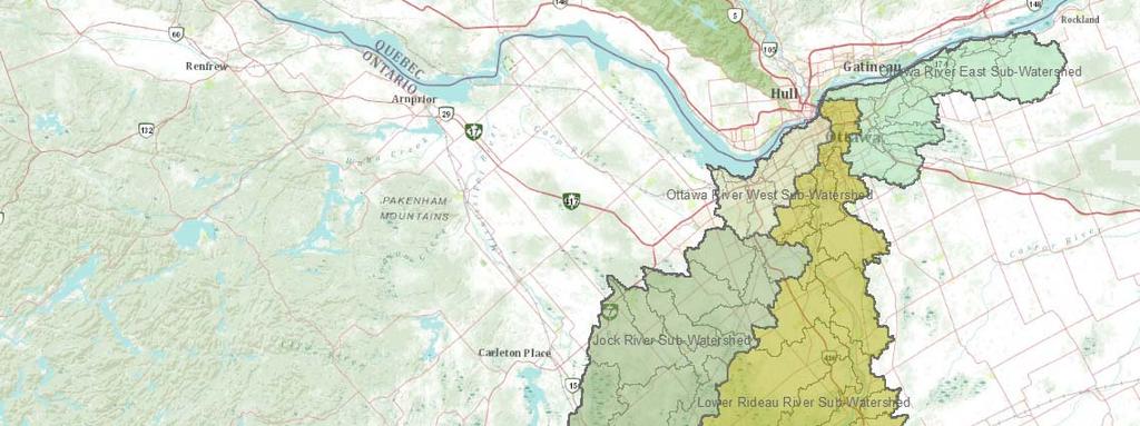


8 Map showing every watershed
9 Reports draw from: RVCA Monitoring Programs Surface Water Quality Baseline/Watershed Watch Macro-Stream/Benthic Invertebrate Hydrometric RVCA Land Cover Classification RVCA Departmental Input Conservation Lands, Planning and Regulations, Stewardship, Watershed Science Municipal Input Agency Input
10 Monitoring and Science Content Scientifically developed field surveys and methods from RVCA s Watershed Watch (Lake Partners), Baseline Monitoring (PWQN), Macro-Stream Assessment (OSAP), Benthic Invertebrate (OBBN) and Land Cover Classification Programs Rigorous data analysis and extensive reporting prepared by RVCA technical staff (in areas of surface water quality, shoreline and instream aquatic habitats and forest/wetland ecology) using established protocols (CCME WQI, PWQO, FBI, SOLRIS)
11 Subwatershed Report State of the Environment Indicators (5) Water Quality Forest Cover Wetland Cover Shorelines Water Levels (new)


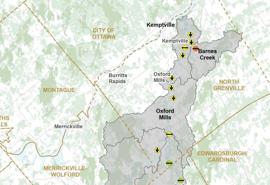
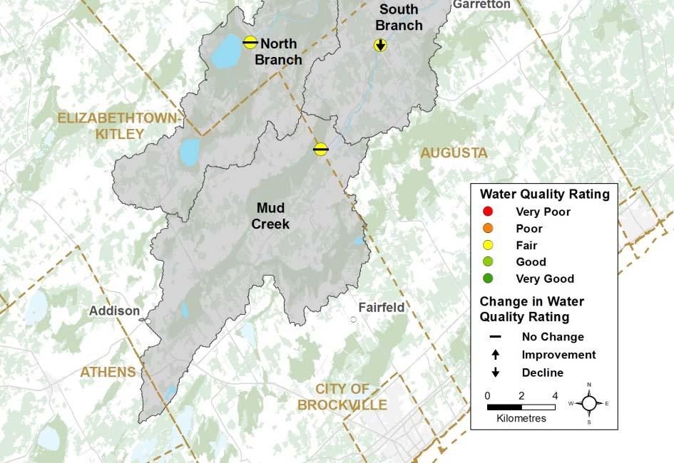
12 Example of Subwatershed Report Water Quality Forest Cover


13 Example of Subwatershed Report Wetlands Shorelines Wetland Cover by Catchment Shoreline Cover by Catchment


14 Example of Subwatershed Report Kemptville Creek Average Flows


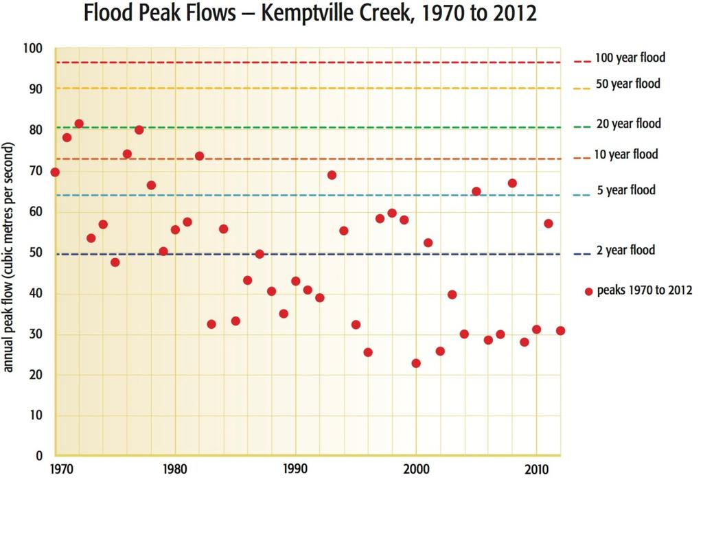
15 Example of Subwatershed Report Kemptville Creek Peak Flows
16 Catchment Report: What it Contains Catchment Facts Analysis of Conditions Surface Water Quality Riparian Conditions Shoreline and Instream Land Cover Stewardship/Catchment Protection Facts Resource Management Issues/Opportunities for Action


17 Catchment Report Catchment Facts General Geography Physical Geography Vulnerable Areas Development Trends Conditions at a Glance Catchment Care


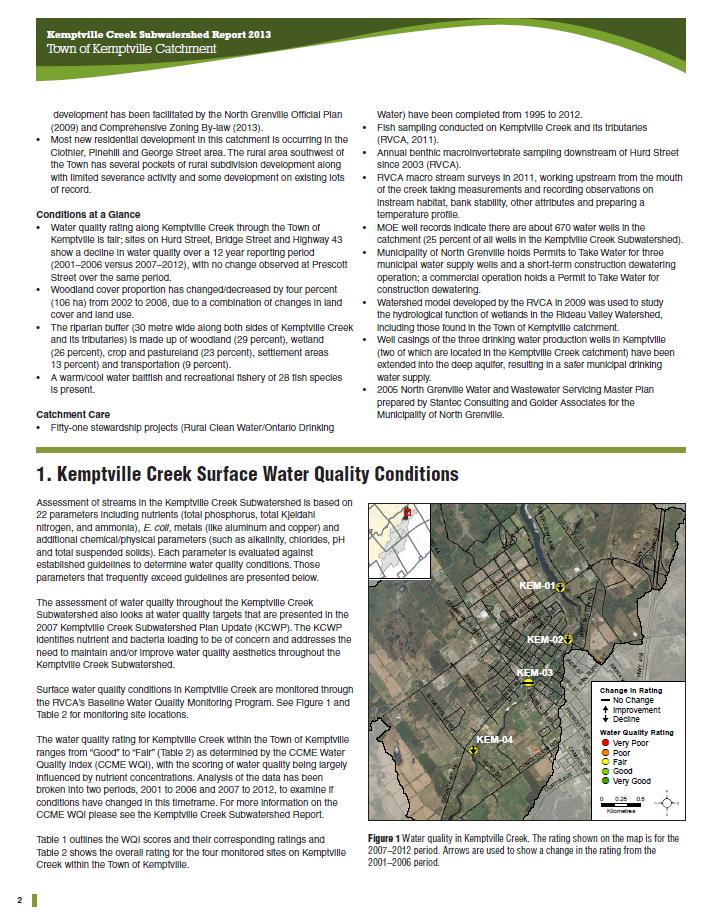
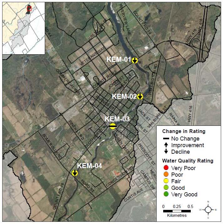
18 Catchment Report Surface Water Quality Water Quality Rating Nutrients E.coli Metals


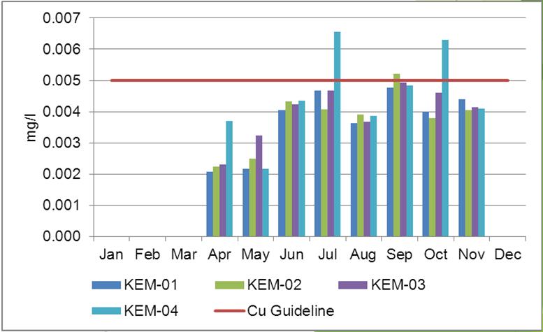
19 Catchment Report Surface Water Quality Water Quality Rating Nutrients E.coli Copper concentrations Copper concentrations


20 Catchment Report Riparian Conditions Riparian Buffer Width Adjacent Land Use Instream Erosion Undercut Stream Banks Stream Shading Instream Woody Debris Overhanging Trees and Branches Anthropogenic Alterations Benthic Invertebrates Habitat Complexity Instream Substrate Instream Morphology Vegetation Type


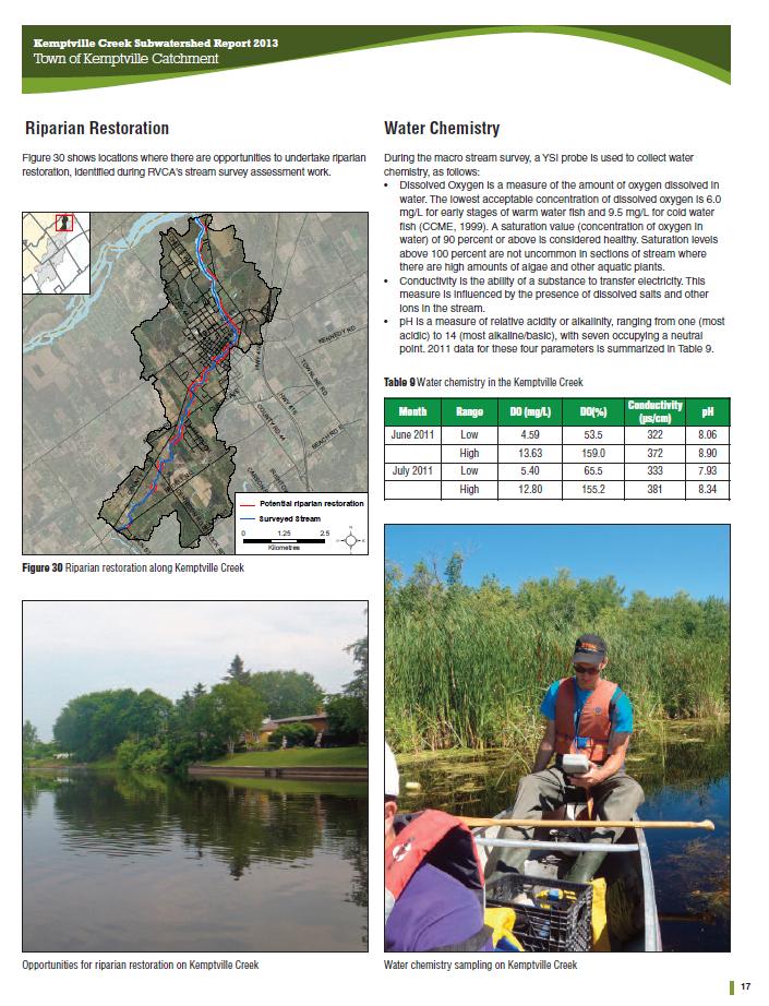

21 Catchment Report Riparian Restoration Water Chemistry


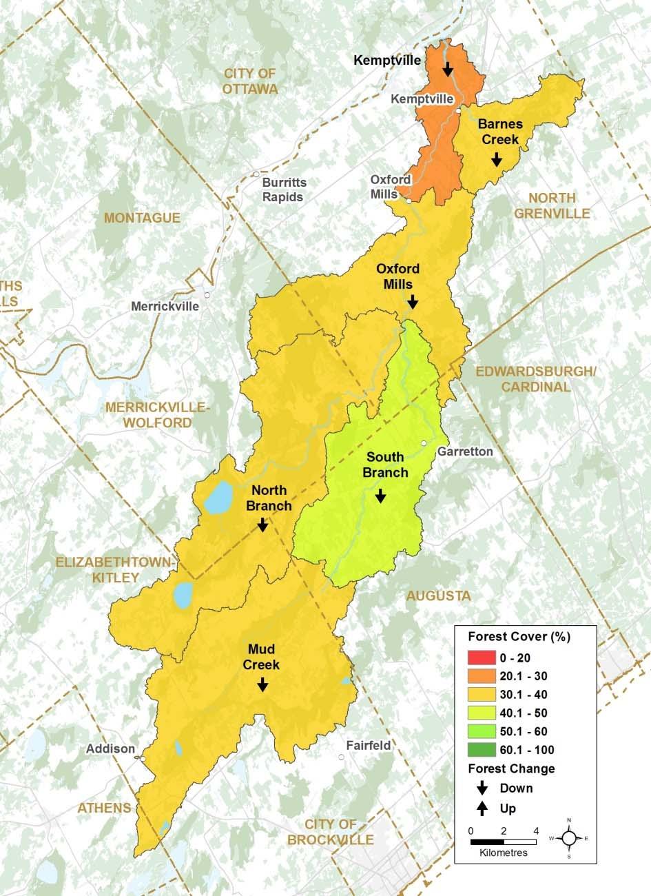
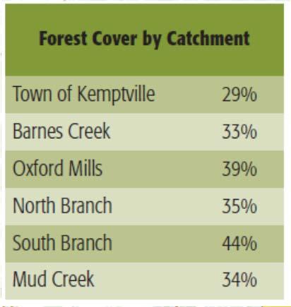
22 Catchment Report Land Cover Woodland Cover Forest Interior Wetland Cover


23 Catchment Report Stewardship and Protection Rural Clean Water Projects Ontario Drinking Water Stewardship Projects Stream, Wetland and Hazard Land Regulation Wellhead Protection Area


24 Catchment Report: Issues and Opportunities for Action Issues E.g., Surface water quality rating is Fair but has declined at three of four site monitoring sites through the Town Opportunities for Action E.g., Investigate cause of reported decline (from Good to Fair ) in the surface water quality rating through the Town to determine the source
25 Report Users: Landowner Uses Seeing environmental conditions on/around their property Understanding cause/effect of water/land resource management activities Informing better land/water resource management decisions NGO Uses Knowing/understanding local environmental conditions Identifying opportunities for community action/landowner projects
26 Users Municipal Uses Understanding municipal environmental conditions Reviewing land-use planning/development applications Providing input to Official Plans/Zoning By-laws Setting priorities for land use change/expansion and infrastructure renewal Land Development/Developer Uses Knowing environmental constraints on/around a site Informing better land-use/development decision-making
27 Users: RVCA Reviewing planning and regulations applications Acquiring Conservation Lands Informing municipalities about watershed conditions and RVCA projects/services Gauging effectiveness of watershed management policies, practices and projects Targeting stewardship applications (tree planting, shoreline naturalization and rural clean water projects) Restoring aquatic and terrestrial habitat restoration
28 Monitor Act and Engage Analyze Report
Rags to Riches - The RVCA Story of Science to Stewardship
 Rags to Riches - The RVCA Story of Science to Stewardship Rideau Valley Conservation Authority Eastern Ontario On Shield off Shield Large Urban population (Ottawa) Rideau Canal connecting St Lawrence to
MURPHY DRAIN CATCHMENT
 The RVCA produces individual reports for 16 catchments in the Lower Rideau subwatershed. Using data collected and analysed by the RVCA through its watershed monitoring and land cover classification programs,
RUDSDALE CREEK CATCHMENT
 The RVCA produces individual reports for 14 catchments in the Tay River Subwatershed. Using data collected and analysed by the RVCA through its watershed monitoring and land cover classification programs,
Kemptville Creek Subwatershed Report 2013 South Branch Catchment
 The RVCA produces individual reports for six catchments in the Kemptville Creek Subwatershed. Using data collected and analysed by the RVCA through its watershed monitoring and land cover classification
BOBS LAKE CATCHMENT TAY RIVER SUBWATERSHED REPORT 2011
 Catchment Facts During the 1950 s, electrification became available around the lake and the pace of waterfront lot development notably increased. Over the last 30 years there has been a trend to larger
Carp Creek 2013 Summary Report
 Monitoring Activity in the Carp River Watershed In 2012, Mississippi Valley Conservation Authority (MVCA) worked with Friends of the Carp River (FCR) on a preliminary assessment of the Carp River. This
SAWMILL CREEK CATCHMENT
 Catchment Facts The lower and middle reaches of Sawmill Creek are highly urbanized and the creek corridor is degraded and confined by development and transportation infrastructure including the Airport
Rideau Lakes. Subwatershed Report. A report on the environmental health of the
 s Subwatershed Report 2014 A report on the environmental health of the s Welcome to the s Subwatershed The Watershed Ottawa River West Ottawa River East ( Manotick Richmond ( Jock River Lower Kemptville
WATERSHED. Maitland Valley. Report Card 201
 Maitland Valley WATERSHED Report Card 201 The Maitland Valley Conservation Authority has prepared this report card as a summary on the state of our forests, wetlands, surface water, and ground water resources.
NRCS Programs and Practices for Riparian Areas in Hawaii
 NRCS Programs and Practices for Riparian Areas in Hawaii NRCS Pacific Islands Area Hawaii - State (State (PIA) Office Honolulu, Oahu) Seven field offices (Kauai, Oahu, Molokai, Maui, Hawaii) Plant Materials
Maitland Valley WATERSHED
 Maitland Valley WATERSHED Report Card 2018 Maitland Conservation has prepared this report card as a summary of the state of your forests, wetlands, and water resources. WHERE ARE WE? We are one of 36 Conservation
APPENDIX G METHODOLOGY FOR EVALUATING RETROFIT OPTIONS/RETROFIT STUDIES
 APPENDIX G METHODOLOGY FOR EVALUATING RETROFIT OPTIONS/RETROFIT STUDIES G.1 Introduction Retrofitting of existing infrastructure may be required to achieve water balance, water quantity, water quality,
BUSINESS PLAN: Kettle Creek Conservation Authority
 BUSINESS PLAN: Kettle Creek Conservation Authority How does this service contribute to the results identified in the City of London Strategic Plan? A strong economy A vibrant and diverse community A green
Watershed. Rigaud River Report Card. Grades: Forest Conditions Wetland Conditions Surface Water Quality
 Watershed Report ard Grades: + onditions Wetland onditions Surface Water Quality This Watershed Report ard outlines the environmental information for the watershed as of 2006. The information provides
B ig E ast R iver. Stewardship Works! S ubwatershed. Grades. Land Water Wetlands Biodiversity. Not Stressed Not Stressed Not Stressed Vulnerable
 s B ig E ast R iver Land Water Wetlands Biodiversity S ubwatershed T he Big East River Subwatershed is 64,699 hectares in area. Major lakes in the subwatershed include Bella Lake (3.45 km2) and Rebecca
H ollow R iver. Stewardship Works! S ubwatershed. Grades. Land Water Wetlands Biodiversity. Not Stressed Not Stressed Not Stressed Vulnerable
 s H ollow R iver Land Water Wetlands Biodiversity S ubwatershed T he Hollow River Subwatershed is 40,863 hectares in size and lies predominantly in the Township of Algonquin Highlands in Haliburton County.
Gray s Creek. Gray s Creek
 Gray s Creek 1 Grades F + Forest Conditions B Wetland Conditions C - Surface Water Quality This Watershed Report Card outlines the environmental information for the Gray s Creek watershed as of 2017. The
BMP 5.4.2: Protect /Conserve/Enhance Riparian Areas
 BMP 5.4.2: Protect /Conserve/Enhance Riparian Areas The Executive Council of the Chesapeake Bay Program defines a Riparian Forest Buffer as "an area of trees, usually accompanied by shrubs and other vegetation,
Voyageur Creek 2013 Summary Report
 Voyageur Creek 2013 Summary Report Watershed Features 6.53 square kilometres Area 0.15% of the Rideau Valley watershed 15% agriculture 51% urban 33% forest Land Use 1% rural land-use 0% wetlands 0% unclassified
TAY RIVER. Subwatershed Report. A report on the environmental health of the Tay Watershed
 TAY RIVER Subwatershed Report 2017 A report on the environmental health of the Tay Watershed 1 Welcome to the Tay River Subwatershed Awatershed is an area of land that drains to a river, lake or stream.
Riparian Areas. 101 An overview. Prepared by: Jacque Sorensen, M.Sc. TRU Department of Natural Resource Sciences
 Riparian Areas 101 An overview Prepared by: Jacque Sorensen, M.Sc. TRU Department of Natural Resource Sciences February 11, 2015 Presented for the Gardom Lake Planning Committee Today s focus Riparian
Watts Creek 2014 Summary Report
 Monitoring Activity in the City of Ottawa In 2012, Mississippi Valley Conservation Authority (MVCA) and the Friends of the Carp River (FCR) collaborated to undertake a broad scale assessment of potential
Irish Creek. Catchment
 Irish Creek Catchment Middle Rideau Subwatershed Report 2015 Middle Rideau Subwatershed Report 2015 IRISH CREEK CATCHMENT The RVCA produces individual reports for ten catchments in the Middle Rideau subwatershed.
RIDEAU RIVER - HOGS BACK CATCHMENT
 The RVCA produces individual reports for 16 catchments in the Lower Rideau subwatershed. Using data collected and analysed by the RVCA through its watershed monitoring and land cover classification programs,
THE ROLE OF CONSERVATION AUTHORITIES IN THE MANAGEMENT OF LAKES AND RIVERS IN THE KAWARTHA S. State of the Lakes Workshop October 27, 2008
 THE ROLE OF CONSERVATION AUTHORITIES IN THE MANAGEMENT OF LAKES AND RIVERS IN THE KAWARTHA S State of the Lakes Workshop October 27, 2008 Conservation Authority Jurisdiction Conservation Authority Mandate
Goose Creek Watershed Assessment Summary October 2003
 Goose Creek Watershed Assessment Summary October 2003 The Goose Creek Watershed The Goose Creek watershed is 385 square miles, covering nearly half of Loudoun County and one-quarter of Fauquier County
Forest & Range Evaluation Program
 Forest & Range Evaluation Program Riparian Management Effectiveness & the Fish Value Post-Harvest Assessments of Riparian, Stream, & Fish Habitat Conditions Peter J. Tschaplinski Ministry of Environment
Urban and Community Forestry Working Together to Cultivate Green Infrastructure
 Urban and Community Forestry Working Together to Cultivate Green Infrastructure Regional Tree and Shade Summit Phoenix, Arizona March 9, 2011 1 Presentation Scope Provide a general description of the State
UTILIZING COLLABORTIVE REGIONAL BASED PRIORITIZATION TO GARNER SUPPORT AND FUNDING FOR RESTORATION IMPLEMENTATION PROGRAMING
 UTILIZING COLLABORTIVE REGIONAL BASED PRIORITIZATION TO GARNER SUPPORT AND FUNDING FOR RESTORATION IMPLEMENTATION PROGRAMING Ralph Toninger, Associate Director Resource Management Projects Group Toronto
Black Creek. Catchment
 Black Creek Catchment Middle Rideau Subwatershed Report 2015 Middle Rideau Subwatershed Report 2015 BLACK CREEK CATCHMENT The RVCA produces individual reports for ten catchments in the Middle Rideau subwatershed.
How Much Habitat Is Enough? How Much Disturbance is Too Much?
 How Much Habitat Is Enough? How Much Disturbance is Too Much? Jocelyn Sherwood Canadian Wildlife Service - Ontario January 27 th, 2017 Page 2 April 19, 2017 Page 3 April 19, 2017 Grasslands Forest Wetlands
Banking for the future. Planting trees to save rivers
 Banking for the future Planting trees to save rivers Woodland and rivers: the perfect combination Trees are proven to help restore our rivers. Woodland planting guarantees results, creates new opportunities
Headwater Drainage Features
 Headwater Drainage Features Their Natural Functions and an Interim Guideline for their Evaluation, Classification and Management Susan Jorgenson (CVC) & Laura Del Giudice (TRCA) Urban development within
Introduction. Mandate
 Page 1 of 11 Introduction This report is intended to provide guidance in establishing a range of priority actions for MVCA to fulfill its mandate and responsibilities as it addresses the emerging challenges
Don t Mow. Let it Grow!
 Don t Mow. Let it Grow! The Science Behind the Need for Riparian Buffer Protection. Chelsea Walker, WCD Watershed Specialist chelsea@wcdpa.com 724-837-5271 What is a Riparian Buffer? A riparian buffer
Background. AEM Tier 2 Worksheet Stream & Floodplain Management. Glossary
 AEM Tier 2 Worksheet Stream & Floodplain Management Glossary Bankfull Stage: The stage at which water starts to flow over the flood plain; the elevation of the water surface at bankfull discharge. (This
Otonabee Region WATERSHED
 Otonabee Region WATERSHED Report Card 2018 Otonabee Conservation has prepared this report card as a summary of the state of your forests, wetlands, and water resources using data from 2012 to 2016. WHERE
CITY OF AUSTIN'S REGULATORY FRAMEWORK FOR CREEK PROTECTION
 CITY OF AUSTIN'S REGULATORY FRAMEWORK FOR CREEK PROTECTION Liz Johnston, Watershed Protection Department Urban Riparian Symposium February 15 17, 2017 Houston, TX Valuable Resource Drinking Water Intake
Lake Fork of the Gunnison Watershed: Status and Stewardship. Camille Richard, Project Director
 Lake Fork of the Gunnison Watershed: Status and Stewardship Camille Richard, Project Director Upper Gunnison Basin Lake Fork Watershed 7,500 14,309 ft Sagebrush to alpine 432 square miles Population 900
How Much Habitat is Enough?
 How Much Habitat is Enough? Canadian Wildlife Service 2017 Third Edition Page 2 April 19, 2017 Grasslands Forest Wetlands Riparian & Watershed Page 3 April 19, 2017 Significant impairment in stream At
Stream and Watershed Ecology and Protection. Jay Kilian Maryland Department of Natural Resources Annapolis, Maryland
 Stream and Watershed Ecology and Protection Jay Kilian Maryland Department of Natural Resources Annapolis, Maryland Some Maryland streams are easily recognizable But, the vast majority of Maryland streams
East Holland River Project: Final Report.
 East Holland River Project: 2007-2012 Final Report www.lsrca.on.ca Page 1 The East Holland River Background Under considerable development pressure, and already one of the most populated and polluted river
Developing a multi-metric habitat index for wadeable streams in Illinois (T-25-P-001).
.") T E C H N I C A L R E P O R T Developing a multi-metric habitat index for wadeable streams in Illinois (T-25-P-001). Annual Segment Report to the Illinois Department of Natural Resources. Laura L. Sass,
T E C H N I C A L R E P O R T Developing a multi-metric habitat index for wadeable streams in Illinois (T-25-P-001). Annual Segment Report to the Illinois Department of Natural Resources. Laura L. Sass,
OurFuture. Protecting. March Ontario Provincial Plans and Conservation Authorities
 Protecting OurFuture Ontario Provincial Plans and Conservation Authorities March 2015 Greenbelt Plan I Niagara Escarpment Plan I Growth Plan for the Greater Golden Horseshoe I Oak Ridges Moraine Conservation
ADDRESSING CLIMATE CHANGE ADAPTATION IN EASTERN ONTARIO APRIL 15, 2013
 ADDRESSING CLIMATE CHANGE ADAPTATION IN EASTERN ONTARIO APRIL 15, 2013 IPCC DEFINITION UNFCCC DEFINITION Climate change in Intergovernmental Panel on Climate Change (IPCC) usage refers to a change in the
Ontario Surface Water Monitoring Programs
 Water Quality of Surface Water: Monitoring and Protection September 24, 2005 Julie Schulenburg Surface Water Specialist Ontario Surface Water Monitoring Programs Provincial Water Quality Monitoring Program
Conservation Authorities Act Review
 Conservation Authorities Act Review What it is: As a first step, the Ministry of Natural Resources and Forestry has developed a Discussion Paper which is posted on the provincial government s Environmental
Stream Health. Stream Bugs Our Stream Health Communicators. Upper Nottawasaga River Stream Health. NVCA Science & Stewardship
 NVCA Science & Stewardship Stream Health Upper Nottawasaga River, 2015 Stream Bugs Our Stream Health Communicators Stream bugs (benthic macroinvertebrates) are organisms that spend much or all of their
Programmatic Environmental Assessment Forest-Wide Erosion Abatement USDA Forest Service Shawnee National Forest
 Programmatic Environmental Assessment Forest-Wide Erosion Abatement USDA Forest Service Shawnee National Forest Alexander, Gallatin, Hardin, Jackson, Johnson, Massac, Pope, Saline, Union and Williamson
RIDEAU RIVER - RIDEAU FALLS CATCHMENT
 Catchment Facts An intensively, urbanized reach within the City of Ottawa with some large expanses of green space found along the river corridor; the only reach in the Lower Rideau that remains in its
Stream Restoration Proposal 2014, Plum Run Tributary West Branch
 West Chester University Digital Commons @ West Chester University Biology Student Work Biology 2014 Stream Restoration Proposal 2014, Plum Run Tributary West Branch Jesse McLaughlin West Chester University
Watershed Health Assessment Framework. Watershed Report Card:
 Watershed Health Assessment Framework "Managing for System Health" Watershed Report Card: People and Places: Watershed Population: 2 census - 1, 21 census - 1,7 Largest Cities - Population: Blackduck -
ELK RAPIDS TOWNSHIP WATER QUALITY ACTION PLAN
 ELK RAPIDS TOWNSHIP WATER QUALITY ACTION PLAN Elk-River-Chain-of-Lakes Gaps Analysis Project The Watershed Center Grand Traverse Bay Tip of the Mitt Watershed Council Michigan Department of Natural Resources
VIDEO: Riparian Forest Buffers: The Link Between Land & Water
 VIDEO: Riparian Forest Buffers: The Link Between Land & Water Introduction to Riparian Buffers Adapted from: Riparian Forest Buffers: The Link Between Land & Water. Maryland Cooperative Extension. Wye
5.2-2 Progress Report and Future Outlook
 5.2-2 Progress Report and Future Outlook Presentation to Peel Regional Council By Deborah Martin-Downs June 22, 2017 5.2-3 Outline 2016 Highlights and 2017 Accomplishments to Date Climate Risk Methodology
Water Quality Stewardship Plan (WaQSP)
") Salt Lake Countywide Water Quality Stewardship Plan (WaQSP) Natalie Rees Salt Lake County Flood Control & Engineering Division 2008 Watershed Symposium COUNTY RESPONSIBILITY AND AUTHORITY Salt Lake County
Salt Lake Countywide Water Quality Stewardship Plan (WaQSP) Natalie Rees Salt Lake County Flood Control & Engineering Division 2008 Watershed Symposium COUNTY RESPONSIBILITY AND AUTHORITY Salt Lake County
Grand Traverse Bay Watershed Protection Plan:
 Grand Traverse Bay Watershed Protection Plan: An Overview Sarah U Ren Program Director The Watershed Center 231-935-1514, suren@gtbay.org The Grand Traverse Bay Watershed 973 square miles Bay Volume =
Mock Stream Habitat Assessment: Bringing the outside in!
 Mock Stream Habitat Assessment: Bringing the outside in! Objectives: At the end of this activity, youth should be able to: Assess the overall health of a stream habitat Apply the terms abiotic and biotic
Lakeshore Capacity July, 2018
 WLPP INFORMATION BULLETIN Lakeshore Capacity July, 2018 This WLPP Bulletin provides information on the concept and approach used to define, calculate and assess lakeshore capacity. In addition, the Bulletin
Lake Creek Watershed Management Plan Public Meeting. Arrowhead Lake May 3, :00 PM
 Lake Creek Watershed Management Plan Public Meeting Arrowhead Lake May 3, 2018 6:00 PM Agenda I. Welcome and Introductions II. III. IV. Watershed Basics Overview of Lake Creek Watershed Elements of a Successful
Oshawa Creek Watershed Management Plan EXECUTIVE SUMMARY
 Oshawa Creek Watershed Management Plan EXECUTIVE SUMMARY The Central Lake Ontario Conservation Authority (CLOCA) has recognized the need to prepare comprehensive management strategies for all of its watersheds.
awetlands aprairie aforests ahabitat for Fish, Game & Wildlife
 Rec. H1 priority land habitats pp. 63-67 Priority areas identified in integrated mapping assessing critical land habitat and threats to habitat pp.33-63 o Mapping is scalable for use in localized areas
Rideau Lakes Subwatershed Report 2014 LOWER RIDEAU LAKE CATCHMENT
 LOWER RIDEAU LAKE CATCHMENT The RVCA produces individual reports for eight catchments in the Rideau Lakes subwatershed. Using data collected and analysed by the RVCA through its watershed monitoring and
ANCR INDIVIDUAL RESPONSES SUMMARY: 2/11/04 WATER RESOURCES GOALS AND OBJECTIVES
 ANCR INDIVIDUAL RESPONSES SUMMARY: 2/11/04 WATER RESOURCES GOALS AND OBJECTIVES Goal 1: Protect the health and safety of the Dane County population. a. Prevent development that may have an adverse effect
INDIAN CREEK WATERSHED PLAN EXECUTIVE SUMMARY
 INDIAN CREEK WATERSHED PLAN EXECUTIVE SUMMARY The Indian Creek Watershed covers a 38 square mile area in southern Lake County, Illinois that drains 24,116 acres before discharging into the Des Plaines
Water and Watersheds. Data Maps Action
 Water and Watersheds Data Maps Action What is the Wildlife Action Plan? Restore rare wildlife and habitats. Keep common species common. 2015 Revision: Partners in Conservation Science 2015 Revision Data
Natural Systems Planning Primer
 Natural Systems Planning Primer Lise.Guevremont@ottawa.ca Amy.Macpherson@ottawa.ca Land Use and Natural Systems Unit Planning and Growth Management November 2015 1 Welcome Policy Framework Development
Disturbance Driven Dynamics in Riparian Zones:
 Disturbance Driven Dynamics in Riparian Zones: Knowledge is Power David Andison & many others. Overview - What is a riparian zone? - What are the management issues? - How are those issues dealt with? -
Watershed Hydrology: Go with the flow. Greg Jennings, PhD, PE
 Watershed Hydrology: Go with the flow Greg Jennings, PhD, PE jenningsenv@gmail.com Streams What are your CHALLENGES? Hydrology too much water Pollutants upstream and on-site Vegetation wrong plants, wrong
Wetlands Project Guidance
 HABITAT Wetlands Project Guidance Stakeholder Informed Introduction Wetlands are lands saturated with water permanently or seasonally. Wetlands are typically defined by three characteristics: 1) The area
Conservation Ontario s Response to Climate Ready: Ontario s Adaptation Strategy and Action Plan June 2011
 Introduction Conservation Ontario s Response to Climate Ready: Ontario s Adaptation Strategy and Action Plan June 2011 C onservation Ontario is the network of 36 Conservation Authorities, local watershed
BANKS TOWNSHIP WATER QUALITY ACTION PLAN
 BANKS TOWNSHIP WATER QUALITY ACTION PLAN Elk-River-Chain-of-Lakes Gaps Analysis Project The Watershed Center Grand Traverse Bay Tip of the Mitt Watershed Council Michigan Department of Natural Resources
Habitat. Summary and Accomplishments. Claude Lafrance St. Clair River RAP Coordinator
 Summary and Accomplishments Claude Lafrance St. Clair River RAP Coordinator St. Clair River AOC Symposium The Path to a Healthy River Working Towards Delisting the St. Clair River June 7, 2012 Sarnia,
OKANAGAN WATER PROJECTS GET FUNDS TO MOVE AHEAD
 April 17, 2018 FOR IMMEDIATE RELEASE OKANAGAN WATER PROJECTS GET FUNDS TO MOVE AHEAD Kelowna, B.C. The Okanagan Basin Water Board (OBWB) has approved $300,000 in funding to 18 projects to help conserve
VILLAGE OF BELLAIRE WATER QUALITY ACTION PLAN
 VILLAGE OF BELLAIRE WATER QUALITY ACTION PLAN Elk-River-Chain-of-Lakes Gaps Analysis Project The Watershed Center Grand Traverse Bay Tip of the Mitt Watershed Council Michigan Department of Natural Resources
Stormwater Management Tools: Real-Life Solutions for a Resilient Community Riparian Corridor Protection
 Stormwater Management Tools: Real-Life Solutions for a Resilient Community Riparian Corridor Protection Montgomery County Planning Commission October 24, 2013 Eric Jarrell, Assistant Section Chief, Community
2018 BUDGET PRESENTATION
 2018 BUDGET PRESENTATION To Peel Regional Council November 16, 2017 By Chief Administrative Officer Deborah Martin-Downs 1 Outline 2017 and 2018 Activities 2018 Budget Underfunded Budget Pressures 2 A
STREAM RESTORATION PURPOSE, PRACTICE, AND METHODS. By Marcus Rubenstein, CPESC
 STREAM RESTORATION PURPOSE, PRACTICE, AND METHODS By Marcus Rubenstein, CPESC WHAT IS STREAM RESTORATION? The return of a stream s lost natural functions, usually resulting from watershed alterations,
Lesson 2-2: Riparian Zones
 2-14 Lesson 2-2: Riparian Zones Time of Lesson: 1 hour Rationale: The purpose of this lesson is to define what a riparian zone is and link its importance for fish and other animals, and humans, and the
Lakeshore Capacity July, 2018
 WLPP INFORMATION BULLETIN Lakeshore Capacity July, 2018 This WLPP Bulletin provides information on the concept and approach used to define, calculate and assess lakeshore capacity. In addition, the Bulletin
879 River Road Development Headwaters Drainage Assessment (HDA)
") 879 River Road Development Headwaters Drainage Assessment (HDA) July 2018 Prepared for Richcraft Homes July 2018 1.0 INTRODUCTION... 1 1.1 Background...1 1.2 Site Overview...2 2.0 METHODOLOGY... 5 3.0
879 River Road Development Headwaters Drainage Assessment (HDA) July 2018 Prepared for Richcraft Homes July 2018 1.0 INTRODUCTION... 1 1.1 Background...1 1.2 Site Overview...2 2.0 METHODOLOGY... 5 3.0
HARPETH RIVER/JONES CREEK WATERSHED-BASED PLAN
 HARPETH RIVER/JONES CREEK WATERSHED-BASED PLAN Harpeth River Watershed Association PO Box 1127 Franklin, TN 37065 March 2007 Table of Contents Page 1. Identification of Causes and Sources 1 1.1. Unnamed
European Climate Adaptation Platform. istockphoto/ AndresGarciaM. Assessing Adaptation Knowledge in Europe: Ecosystem-based Adaptation
 European Climate Adaptation Platform Climate-ADAPT factsheet istockphoto/ AndresGarciaM Assessing Adaptation Knowledge in Europe: Ecosystem-based Adaptation What is ecosystem-based adaptation? Ecosystem-based
Natural Flood Management: the Role of Forestry. Nadeem W. Shah Thomas R. Nisbet Huw Thomas
 Natural Flood Management: the Role of Forestry Nadeem W. Shah Thomas R. Nisbet Huw Thomas 2 Deeside 3 Ballater 4 Cumbria Land use Recognition that land use affects flooding Need to deal with flooding at
Developing a multi-metric habitat index for wadeable streams in Illinois (T-25-P-001).
.") T E C H N I C A L R E P O R T Developing a multi-metric habitat index for wadeable streams in Illinois (T-25-P-001). Annual Segment Report to the Illinois Department of Natural Resources. Leon C. Hinz
T E C H N I C A L R E P O R T Developing a multi-metric habitat index for wadeable streams in Illinois (T-25-P-001). Annual Segment Report to the Illinois Department of Natural Resources. Leon C. Hinz
Enhancing Habitat for Early Successional Species
 Enhancing Habitat for Early Successional Species NFWF CONTACT Amanda Bassow Director, Eastern Partnership Office amanda.bassow@nfwf.org 202-595-2476 and its operating companies Connecticut Light & Power,
How Much is Too Much? Effects-Based versus Stressor-Based Benchmarks and Thresholds and Some Examples from the Elk Valley in the East Kootenays
 How Much is Too Much? Effects-Based versus Stressor-Based Benchmarks and Thresholds and Some Examples from the Elk Valley in the East Kootenays Outline 1. Effects-based versus stressor-based indicators,
Little River Watershed Restoration Project. Mark Powell, Consultant Natural Resources Management
 Little River Watershed Restoration Project Mark Powell, Consultant Natural Resources Management Lessons Learned Strong partnerships RC&D, Soil and Water, 2 counties, Albemarle Commission, Universities,
14. Sustainable Forestry Principals
 14. Sustainable Forestry Principals Fish River Lakes Concept Plan Addendum Materials April 2018 14. SUSTAINABLE FORESTRY PRINCIPLES In response to our discussion with LUPC Staff and others on the topic
Juncrock Timber Sale Draft Environmental Impact Statement. Appendix G Soils
 Juncrock Timber Sale Draft Environmental Impact Statement Appendix G Soils Soil Condition Monitoring on the Barlow Ranger District of the Mt. Hood National Forest 1999 The Barlow Ranger District conducts
Suggested Citation: Report Prepared by: Shari Clare and Shantel Koenig
 Front Cover Photo: Aerial view of a riparian area in the North Saskatchewan River basin, captured from a unmanned aerial vehicle. Credit: Fiera Biological Consulting Ltd. Suggested Citation: Fiera Biological
Maintaining Riparian Areas and Wetlands
 Maintaining Riparian Areas and Wetlands Riparian areas are the lands along the banks of our rivers, lakes, and tidal waters. Many riparian areas not only border surface waters, but they are often adjacent
Water Quality in the Rat River St.Malo Watershed:
 Water Quality in the Rat River St.Malo Watershed: Current conditions, historical trends, and potential actions. September 8 th, 2010 Jennifer Stephens Water Quality Management Section Manitoba Water Stewardship
Community Benefits of Land Restoration
 Community Benefits of Land Restoration Introducing Green Infrastructure for Coastal Resilience Matt Fulda, Acting Director Monroe May 23 rd, 2017 Avery Point Campus, University of Connecticut Easton Trumbull
TORCH LAKE TOWNSHIP WATER QUALITY ACTION PLAN
 TORCH LAKE TOWNSHIP WATER QUALITY ACTION PLAN Elk-River-Chain-of-Lakes Gaps Analysis Project The Watershed Center Grand Traverse Bay Tip of the Mitt Watershed Council Michigan Department of Natural Resources
Lake Management Planning in the Rideau Valley Watershed
 Lake Management Planning in the Rideau Valley Watershed Forum National Sur les Lacs June 5, 2008 Lynn Preston Watershed Planning Co-ordinator ordinator Conservation Authorities in Ontario 36 in Ontario
Assessing Habitat in Watersheds. Sabrina Drill UC Cooperative Extension Los Angeles and Ventura
 Assessing Habitat in Watersheds Sabrina Drill UC Cooperative Extension Los Angeles and Ventura sldrill@ucdavis.edu 323-260 260-3404 What is Habitat? The environment in which a plant and animal lives, and
Jan Moryk, Project Manager, Environmental Monitoring and Data Management Section, TRCA
 Distribution of Brook Trout in the TRCA Jurisdiction and what Legislation, Policies, and Guidelines do Conservation Authorities have at their disposal to Protect Brook Trout Habitat Jan Moryk, Project
+ Bioengineering Project on Graham Creek. Completed by City Stream Watch and their amazing volunteers!
 + Bioengineering Project on Graham Creek Completed by City Stream Watch and their amazing volunteers! + Project Design In response to landowner concerns regarding an eroding shoreline on Graham Creek,
C. Staffing Needs Approximately 150 staff days TSA #3 staff time will also be utilized.
 2017 Annual Plan I. Introduction The purpose of this annual plan is to detail work items that will be completed in 2017. The annual plan will provide a tool for SWCD staff and supervisors to evaluate program