ENVIRONMENTAL ASSESSMENT WORKSHEET
|
|
|
- Judith Wood
- 6 years ago
- Views:
Transcription
1 ENVIRONMENTAL ASSESSMENT WORKSHEET Minnesota Sex Offender Program Moose Lake Expansion Project Prepared for Minnesota Department of Administration By the Minnesota Department of Human Services November 2006
2 Version 2/99 editorial corrections May, 05 ENVIRONMENTAL ASSESSMENT WORKSHEET Note to preparers: This form and EAW Guidelines are available at The Environmental Assessment Worksheet provides information about a project that may have the potential for significant environmental effects. The Environmental Assessment Worksheet (EAW) is prepared by the Responsible Governmental Unit or its agents to determine whether an Environmental Impact Statement should be prepared. The project proposer must supply any reasonably accessible data for but should not complete the final worksheet. If a complete answer does not fit in the space allotted, attach additional sheets as necessary. The complete question as well as the answer must be included if the EAW is prepared electronically. Note to reviewers: Comments must be submitted to the RGU during the 30-day comment period following notice of the EAW in the EQB Monitor. Comments should address the accuracy and completeness of information, potential impacts that warrant further investigation, and the need for an EIS. 1. Project title: Minnesota Sex Offender Program (MSOP) Expansion Project 2. Proposer: MN Department of Human Services 3. RGU: MN State Architect s Office Alan VanBuskirk Gordon Christofferson Physical Plant Operations Manager Project Manager 444 Lafayette Road North 301 Centennial Building St. Paul, Minnesota Cedar Street Ph: St. Paul, MN, Fax : Ph: alan.vanbuskirk@state.mn.us Fax : gordon.christofferson@state.mn.us 4. Reason for EAW preparation: (check one) EIS Scoping X Mandatory EAW Citizen Petition RGU Discretion Proposer Volunteered If EAW or EIS is mandatory, give EQB rule category subpart number and subpart Minnesota Rules, Chapter , Subpart 14, Industrial, Commercial, and Institutional Facilities. 5. Project location: County: Carlton City/Township: City of Moose Lake Section 28, Township 46 North, Range 19 West Attach each of the following to the EAW: County map showing the general location of the project. Figure 1 presents a county map with the project location. U.S. Geological Survey 7.5 minute, 1:24,000 scale map indicating project boundaries (photocopy acceptable); Figure 2 presents the USGS map with the project location. Site plan showing all significant project and natural features. Figure 3 is a site plan of the project and Figure 4 is a map with boundaries of the Historic District identified by the Minnesota SHPO. 2
3 6. Description: a. Provide a project summary of 50 words or less to be published in the EQB Monitor. The Minnesota Department of Human Services proposes to expand the existing Minnesota Sex Offender Program (MSOP) facility at Moose Lake from 150 to 950 beds, to accommodate current and projected program needs. The project will be completed in two phases of 400 beds each. Phase I construction is scheduled to be completed Spring of 2009, and Phase II construction is scheduled to be completed Spring of b. Give a complete description of the proposed project and related new construction. Attach additional sheets as necessary. Emphasize construction, operation methods and features that will cause physical manipulation of the environment or will produce wastes. Include modifications to existing equipment or industrial processes and significant demolition, removal or remodeling of existing structures. Indicate the timing and duration of construction activities. The MSOP expansion project facilities will include the following primary components: 1. Intake Processing 2. Education/Treatment (Classrooms, Treatment Staff Offices) 3. Housing /Residences 4. Food Service (Potential for Outsourcing) 5. Laundry Component (Potential for Outsourcing) 6. Medical Component (For Medications Distribution) 7. Recreational 8. Industry Components 9. Security & Investigations Components 10. Site Security Components (Fencing, Patrol Road, Lighting, Video Surveillance) 11. Protective Isolation 12. Administrative Support Staff Components 13. Expanded Visitation Capacity 14. Staff and Visitor Parking Components (Surface Lots, Walks, Curbs, Landscaping, Loading Docks, Delivery Areas) 15. Utility Infrastructure Components Phase I will include housing for 400 patients, a new foodservice building with equipment to feed 400 patients, therapy staff offices, and a central plant building designed to serve both Phase I and II buildings, with equipment only for Phase I. Phase II will include housing for an additional 400 patients and support facilities for 800 patients. Support facilities will include therapy rooms, classrooms, library, dining rooms, expanded visiting spaces (including video visitation for non-contact visits), protective isolation, intake, centralized medication distribution, security offices, staff offices, administration offices, staff locker and changing rooms, staff training rooms, maintenance offices and workshop, a patient mart (canteen), additional kitchen equipment, and a warehouse with loading dock facilities. 3
4 The existing sewer line connecting the MSOP facility through the Department of Correction s (DOC) Minnesota Correctional Facility (MCF)-Moose Lake facility and into the City sewer system has been determined to be inadequate to serve the expanded population of both phases of the project, but is of adequate size to handle the additional capacity of Phase I. The slope of the existing line, however, does not meet current codes. As a result, the use of the existing line to serve Phase I will require approval by the Minnesota Department of Labor and Industry (MnDLI). If MnDLI approval is not granted, an additional sewer line from the MSOP facility to the existing City sewer main, west of State Highway 73 via the MCF-Moose Lake property, sized to handle both phases of the project, will be required. If the existing line is allowed to be used for Phase I, a new line will be added in Phase II. Phase I will include a perimeter security patrol road, interior access roads, interior patient pedestrian paths, and expanded staff parking areas. The patrol road, access roads, and parking areas will be gravel in Phase I and paved in Phase II. Interior patient paths will be paved. Phase II will include paved expansions of all of these vehicular and pedestrian circulation paths, as well as, development of interior recreation fields and paved activity courts. Phase I has been funded through design and construction, while Phase II has been funded through design only. It is anticipated that funding for Phase II construction will be requested in the 2008 legislative session as part of the DHS capital appropriation funding request. Project Schedule Summary-Phase I Legislative Funding Spring 2006 Project Kick Off/Start Date Summer 2006 Schematic Design Completion September 2006 Design Development Completion December 2006 Construction Documents Completion April 2007 Bidding Completion May 2007 Construction Start June 2007 Construction Completion Spring 2009 Project Schedule Summary-Phase II Legislative Funding Spring 2006 (Design) 2008 (Construction) Project Kick Off/Start Date Summer 2006 Schematic Design Completion September 2006 Design Development Completion December 2006 Construction Documents Completion June 2007 Legislative Funding for Construction Spring 2008 Bidding Completion August 2008 Construction Start September 2008 Construction Completion April 2010 c. Explain the project purpose; if the project will be carried out by a governmental unit, explain the need for the project and identify its beneficiaries. The MSOP facility provides care and treatment programs for sex offenders that have been committed by the courts for treatment. The program currently has capacity for 496 patients, spread across three locations, including MSOP-Moose Lake, the Minnesota Security Hospital at St. Peter, and at temporary facilities at MCF-Moose Lake. 4
5 The purpose of the MSOP Expansion Project is to allow the Department of Human Services (DHS) to expand patient capacity at its primary existing facility, to meet the needs of a rapidly growing program and to consolidate the program on a single campus for efficiency of treatment and operations. Program growth was brought about primarily to a change in the DOC s sex offender referral policy in This has led to a significant increase in the number of individuals referred for civil commitment into the MSOP program. Based on the anticipated increase in referrals, the DHS 6-year capital plan was revised to anticipate an overall expansion of 800 beds by The MSOP program does not have existing permanent facilities capable of handling the increase in the number of program participants. The two-phased expansion will provide permanent facilities to accommodate all current program participants and provide space for projected future capacity. Consolidating the MSOP program into one campus eliminates the need to transfer high-risk patients back and forth between three campuses and locates specialized, trained staff at a single location to promote consistency, efficiency, and effectiveness of treatment programs. This allows the DHS to maintain consistent level of security, focus program expertise, and enable the MSOP program to incorporate a more cost effective residential building model. The intent of the expansion project is to increase the capacity of MSOP facility by 800 beds, in two phases of 400 beds each, for a total facility capacity of 950. The phased approach is a result of available funding appropriated by the legislature to develop the first 400 beds as quickly as possible to meet the immediate needs of the program, to be followed with additional funding to meet the long-term needs. Project beneficiaries include the citizens of the State of Minnesota, the Moose Lake community, and the MSOP program participants. d. Are future stages of this development including development on any outlots planned or likely to happen? _X_Yes No If yes, briefly describe future stages, relationship to present project, timeline and plans for environmental review. Based on estimates from the City of Moose Lake, the operation of Phase I of this program can be accommodated within the current capacity of the Moose Lake Wastewater Facility, but Phase II expansion will exceed the current capacity. The City of Moose Lake is in the process of creating a plan for wastewater facility improvements/expansion to accommodate the growing residential, industrial, and institutional needs within the Moose Lake Wastewater Collection and Treatment Facility planning area. Because the MSOP program requires wastewater treatment facilities to operate, the need for wastewater facility expansion is considered a connected action under MN Rules subpart 9b. The Facility Plan being prepared by the City of Moose Lake will identify the constraints of the existing system, propose cost-effective long-term solutions to meet the anticipated needs of the service area, and conduct an environmental review of the preferred action in the form of an EAW. The Draft Moose Lake Facility Plan identifies the following schedule of events for activities pertinent to the construction of the MSOP Expansion Project:. 1. Completion of the facility plan by December
6 2. Completion of the EAW during Completion of new facility design/in-service by October 2008 The proposed schedule would have improvements to the Moose Lake Wastewater Collection and Treatment Facility completed before the completion of Phase II of the MSOP Expansion Project. Given the different planning and implementation schedules of the two projects, this EAW will not be able to adequately address the Moose Lake Wastewater Collection and Treatment Facility as it contributes to the MSOP Expansion Project. However, the Moose Lake Wastewater Collection and Treatment Facility must also prepare an EAW according to MN Rule Subpart 18. The EAW for the Moose Lake Wastewater Collection and Treatment Facility will adequately address the environmental aspects of the Moose Lake Facility. A 50-bed expansion was initially planned to follow completion of Phase I and Phase II of this program, but that expansion has been eliminated from further consideration due to the increased unit cost associated with smaller scale construction. At this time, there are no plans for additional expansion outside the Phase I and Phase II MSOP Expansion Project. e. Is this project a subsequent stage of an earlier project? Yes _X_No If yes, briefly describe the past development, timeline and any past environmental review. 7. Project magnitude data Total project acreage Number of residential units: unattached attached maximum units per building Commercial, industrial or institutional building area (gross floor space): total square feet Indicate areas of specific uses (in square feet): Office Retail Warehouse Light industrial Other commercial (specify) Building height Max: Height 45 feet (1-2 stories) nearby buildings Manufacturing Other industrial Institutional 365,421 square feet Agricultural If over two stories, compare to heights of 8. Permits and approvals required. List all known local, state and federal permits, approvals, and financial assistance for the project. Include modifications of any existing permits, governmental review of plans and all direct and indirect forms of public financial assistance including bond guarantees, Tax Increment Financing and infrastructure. Table 8-1: List of Permits Unit of government Type of application Status City of Moose Building Construction and Demolition Lake/MnDLI-BCSD Permits To Be Obtained City of Moose Lake Industrial Wastewater Discharge Contract Under Discussion City of Moose Lake Zoning Permit To Be Obtained City of Moose Lake Conditional Use Permit for work within a shoreline management area To Be Obtained Minnesota Pollution Air Permit To Be Obtained Control Agency Minnesota Pollution Control Agency NPDES General Permit to Discharge Storm water To Be Obtained 6
7 Table 8-1: List of Permits Unit of government Type of application Status Minnesota Pollution Control Agency UST To Be Obtained Minnesota Department of Review, inspection and certification of Food Health Service Building To Be Obtained City of Moose Lake Revised Water Appropriation contract To Be Obtained Carlton County Planning Wetland Conservation Act Permit To Be Obtained and Zoning Department US Army Corps of Engineers State Historic Preservation Office (SHPO) Section 404 Permit for dredging and filling of navigable waters/jurisdictional wetlands Concurrence on Findings of Cultural Resource Impacts If Necessary To Be Obtained MnDLI Plumbing Review To Be Obtained 9. Land use. Describe current and recent past land use and development on the site and on adjacent lands. Discuss project compatibility with adjacent and nearby land uses. Indicate whether any potential conflicts involve environmental matters. Identify any potential environmental hazards due to past site uses, such as soil contamination or abandoned storage tanks, or proximity to nearby hazardous liquid or gas pipelines. Current land use of the development site is an institutional facility. Surrounding land uses include: Institutional to the west and southwest. The existing MSOP facilities are directly west of the proposed expansion. The MCF Moose Lake is located to the west of the MSOP facility. Moosehead Lake is located north and northwest of the site. The City of Moose Lake is located across the lake from the MSOP facility. The Moose Lake State Park is located east of the site. Highway to the south. State Highway 73 runs east to west along the southern boundary of the State-owned land. The area to the west was used by the State for a State-run hospital from 1938 to Starting in 1989 portions of the grounds were converted to prison facilities. The conversion was completed in The portion of the property to the east of the existing MSOP facility was developed as a State park in 1971 and is still operated as a State park by the Minnesota Department of Natural Resources. Prior to the development, the land was forested and farmed. 10. Cover types. Estimate the acreage of the site with each of the following cover types before and after development: 7
8 Table 10-1: Cover Type Acreage Phase I Phase II Project Total Cover Type Before After Before After Before After Types 1-8 Wetlands Wooded/Forested Brush/Grassland/Cr opland Lawn/Landscaping Impervious Surfaces Other Total If Before and After totals are not equal, explain why: 11. Fish, wildlife and ecologically sensitive resources a. Identify fish and wildlife resources and habitats on or near the site and describe how they would be affected by the project. Describe any measures to be taken to minimize or avoid impacts. The existing facility provides limited wildlife habitat over much of the project area. Nearby wildlife resources include the Moose Lake State Park located east of the MSOP facility and Moosehead Lake located to the north and west of the facility. The habitat in the Moose Lake State Park includes upland mixed deciduous forest, upland and lowland coniferous forest, upland and lowland brushland, plantation conifer stand, manmade ponds, and herbaceous cover. White tail deer are common across the county and would be expected in the Moose Lake State Park to the east. Black bear occur in the area, but prefer large areas of woodland habitat. The mixture of forest, wetland, and open habitats provide suitable habitat for a variety of small mammals (mink, fox, squirrel, rabbits, coyote, and muskrat), waterfowl (Canada geese, wood ducks, and mallards), game birds (ruffed grouse and woodcock), raptors, bald eagles, hawks, and songbirds (robins, chickadees, kingfishers, and blackbirds). Moosehead Lake is a 292-acre lake located north and west of the existing MSOP facility. The lake supports game fish of walleye, northern pike, and bluegill. Design measures to minimize impacts from construction and operation of the MSOP Expansion Project include storm water management ponds to manage water quality and discharge of storm water prior to discharge from the site, mitigation of wetland impacts through creation or enhancement as specified in appropriate permits, and controlling glare from proposed lights. b. Are any state-listed (endangered, threatened or special concern) species, rare plant communities or other sensitive ecological resources such as native prairie habitat, colonial waterbird nesting colonies or regionally rare plant communities on or near the site? _X_Yes No If yes, describe the resource and how it would be affected by the project. Indicate if a site survey of the resources has been conducted and describe the results. If the DNR Natural Heritage and Nongame Research program has been contacted give the correspondence reference number: Describe measures to minimize or avoid adverse impacts. 8
9 The Natural Heritage and Nongame Research Program (NHNRP) was contacted (Attachment 1) and found eight known occurrences of rare species or native plant communities in the vicinity of the project area. These occurrences include two threatened species, four species of special concern, one colonial nesting site, and one species tracked (but no legal status). Based on the locations and habitat requirements (mostly aquatic) listed for each occurrence, the project is not expected to affect any known occurrences of rare features. 12. Physical impacts on water resources. Will the project involve the physical or hydrologic alteration dredging, filling, stream diversion, outfall structure, diking, and impoundment of any surface waters such as a lake, pond, wetland, stream or drainage ditch? X_Yes No If yes, identify water resource affected and give the DNR Protected Waters Inventory number(s) if the water resources affected are on the PWI: Not listed on PWI. Describe alternatives considered and proposed mitigation measures to minimize impacts. Construction of Phase II will result in impacts to the wetland located east of the existing MSOP facility boundaries (see Figure 3). A wetland delineation will be conducted to determine the wetland boundaries. Following the wetland delineation, a wetland delineation report will be prepared and submitted to the U.S. Corps of Engineers (USACE) for jurisdictional determination. Based on site conditions, the wetland basin appears to be isolated and not under USACE jurisdiction. Three design alternatives were analyzed for the project. Avoidance and minimization of wetland impacts were incorporated into the design alternative review for the MSOP Expansion Project. The three alternatives considered are described below. Pre-design Option A expands the facility in a northerly direction as an expansion of the organization of the facility along the existing axis. The two new housing buildings are completely detached, requiring outdoor patient and staff circulation between housing and other buildings. Foodservice and medical functions are centrally located as additions to the existing facility. Industry, Patient Support, Education, and Recreation are combined in a single large building between the housing buildings. A service road to all new buildings would run along the secure perimeter, allowing service vehicle access at the rear of each building. Pre-design Option A was not selected because of the significant topographical features. The west Housing building and the Industry complex are each located on a greater than 20-percent sloping terrain, which would require significant earthwork or retaining walls and their proximity to the lake may be an issue due to the lake setback requirements. This option requires the acquisition of portions of the adjacent Department of Natural Resources (DNR) property. In addition, the location of new construction inside the secure perimeter is not preferred from a security or construction cost perspective. Pre-design Option B arranges the new construction as an adjacent facility to the east of the existing facility. The facilities would share parking and service access with the existing facility, but generally would operate independently. Secure perimeters for each facility could be connected as one, allowing staff, and possibly patients, to move between facilities within one secure perimeter. Patient circulation within the new facility is internally contained, with the exception of external movement to and from the separate Recreation/Industry building to the south. 9
10 Pre-design Option B was not selected because of the operating inefficiencies, unnecessary costs, and security issues. The new facility and secure perimeter is situated on the edge of existing wetlands on the east side of the site. Operating two separate facilities on the same site may result in departmental overlap and inefficiencies. The existing parking lot and access road would have to be relocated to accommodate the new secure perimeter, which would add unnecessary cost to the project and the State. The location of the new areas in relationship to the existing visitor and staff parking lot is undesirable from a security standpoint. Patients being able to see what car a staff member drives, or visitors being tossing distance from the housing areas, are potential problems that can be avoided. Pre-design Option C locates all new construction outside of the existing secure perimeter, simplifying phasing and allowing the existing facility to operate as normally as possible during construction. Locating construction to the east northeast allows for the buildings to be close to the existing facility, while avoiding the prohibitively steep slopes to the north-northwest of the existing facility. The warehouse is located outside of the secure perimeter, allowing for convenient service vehicle access, and would be linked to the main Industry building via a secure connection through the perimeter. Pre-design Option C was selected to move forward into the design phase because of the efficiency of set-up, suitable topography, and safety benefits. External travel distances for staff and patients will be significant from the existing facility to the new buildings, but not as great as other options would present. There is a wetland area that will need to be delineated and mitigated. A portion of the land is currently operated by the DNR and a swap will have to occur in order for the expansion to occur. The lesser need for grading and better adjacencies made it a preferred expansion area. The project will require permits for activities with a wetland. As part of the permitting process, appropriate mitigation will be determined to offset the impacts associated with wetland disturbance of the project. 13. Water use. Will the project involve installation or abandonment of any water wells, connection to or changes in any public water supply or appropriation of any ground or surface water (including dewatering)? Yes _X_No If yes, as applicable, give location and purpose of any new wells; public supply affected, changes to be made, and water quantities to be used; the source, duration, quantity and purpose of any appropriations; and unique well numbers and DNR appropriation permit numbers, if known. Identify any existing and new wells on the site map. If there are no wells known on site, explain methodology used to determine. The MSOP Expansion Project would utilize the existing connections to the Moose Lake Municipal Water supply. Based on information from the Minnesota Geological Survey and the Minnesota County Well Index, there are no existing wells on the site, although there are two wells located on the DOC property to the west, as discussed in question Water-related land use management district. Does any part of the project involve a shoreland zoning district, a delineated 100-year flood plain, or a state or federally designated wild or scenic river land use district? _X_Yes No If yes, identify the district and discuss project compatibility with district land use restrictions. The MSOP Expansion Project would be within 1,000 feet of Moosehead Lake and would be subject to the Carlton County Shoreland Management District zoning requirements. Moose Lake 10
11 is a natural environment shoreland management lake. The county requirements are primarily concerned with developments setback from the ordinary high water mark and from bluff edges to protect visual resources. The project would be required to obtain a permit from Carlton County and demonstrate adherence to zoning requirements. 15. Water surface use. Will the project change the number or type of watercraft on any water body? Yes _X_No If yes, indicate the current and projected watercraft usage and discuss any potential overcrowding or conflicts with other uses. 16. Erosion and sedimentation. Give the acreage to be graded or excavated and the cubic yards of soil to be moved: The project will require grading of about acres. 480,000 cubic yards to be excavated and 490,000 cubic yards of fill. Describe any steep slopes or highly erodible soils and identify them on the site map. Describe any erosion and sedimentation control measures to be used during and after project construction. The project will disturb more than one acre of soil during construction and require a Storm water Pollution Prevention Plan (SWPPP) per the General Permit Authorization to Discharge Storm Water Associated With Construction Activity Under the National Pollutant Discharge Elimination System/State Disposal System Permit Program (General Permit). Application for coverage under the General Permit will be made prior to commencement of land disturbing activities. Both temporary and permanent erosion and sediment control measures will be employed during and after project construction in accordance with the SWPPP requirements in the General Permit. With permitting and compliance, no adverse impacts to water quality from erosion and sedimentation are anticipated as a result of this project. A Grading Plan has not been prepared for the project at this time. The initial goal is to utilize all excavated soils for fill on the site and minimize the need for offsite disposal. 17. Water quality: surface water runoff a. Compare the quantity and quality of site runoff before and after the project. Describe permanent controls to manage or treat runoff. Describe any storm water pollution prevention plans. The site is currently developed. Phase I will add approximately 5.08 acres of impermeable surface and Phase II will add approximately 7.60 acres of impermeable surface. The storm water ponds will be retention ponds designed to hold the 100-year storm event. The existing storm water pond located west of the site will be enlarged to handle runoff from Phase I Housing. The existing pond outlet location will be used. A larger storm water pond is proposed at the southeast corner of the site to handle runoff from Phase II Housing and the additional support buildings. The outlet for this pond will drain to the existing pond located east of the proposed pond. The project will require a National Pollution Discharge Elimination System (NPDES) General Construction Permit. As part of this permit application process a SWPPP will be prepared prior to submitting the permit application. The SWPPP will identify specific storm water pollution protection plans. b. Identify routes and receiving water bodies for runoff from the site; include major downstream water bodies as well as the immediate receiving waters. Estimate impact runoff on the quality of receiving 11
12 waters. The site generally drains towards an unnamed intermittent tributary on the DOC facilities to the west and to Moosehead Lake to the north and west of the project area. With the existing and proposed storm water management measures for the project, there are no expected impacts to Moosehead Lake. 18. Water quality: wastewaters a. Describe sources, composition and quantities of all sanitary, municipal and industrial wastewater produced or treated at the site. Wastewater generated will be domestic wastewater; there will be no change in the composition of wastewater from what is currently discharged from the existing facility. Estimated wastewater generation for the project is 67,500 gallons per day (gpd) or 24.6 million gallon per year (gpy) for each phase, or 135,000 gpd and 49.3 million gpy for both phases combined. b. Describe waste treatment methods or pollution prevention efforts and give estimates of composition after treatment. Identify receiving waters, including major downstream water bodies, and estimate the discharge impact on the quality of receiving waters. If the project involves on-site sewage systems, discuss the suitability of site conditions for such systems. Wastewater from the project will be treated at the Moose Lake Wastewater Treatment Plant. The project does not involve on-site sewage systems. c. If wastes will be discharged into a publicly owned treatment facility, identify the facility, describe any pretreatment provisions and discuss the facility's ability to handle the volume and composition of wastes, identifying any improvements necessary. The current facility discharges to the Moose Lake Wastewater Treatment Plant, operated by the City of Moose Lake. As discussed under question 6.d., the Moose Lake Wastewater Collection and Treatment Facility has capacity to handle the increase wastewater generated under Phase I of the MSOP Expansion Project, but not under Phase II. The Moose Lake Facility is in the process of identifying treatment needs within their planning area (including the MSOP facility) and plan to have facility expansion construction completed and in-service by October of As Phase II of the MSOP Expansion Project is scheduled to be completed in Spring of 2010, the improved wastewater collection and treatment facilities should be able to accommodate the increased wastewater generated under operations of Phase II. The existing sewer line connecting the MSOP facility through the DOC facility and into the City sewer system is of adequate size to accommodate Phase I expansion, but does not meet current codes in terms of slope. The existing line within the DOC site is less than the minimal allowed slope of 0.52 percent. The existing line will not, however, be adequate to accommodate Phase II expansion in terms of either size or slope. As a result, a new sewer line will be constructed as part of the MSOP Expansion Project. Whether the new line will be included in Phase I or Phase II will be determined in consultation with the MnDLI. Pretreatment contracts typically prohibit discharges of: Gasoline, benzene, naptha, fuel oil, or other flammable or explosive liquid, solid or gas. Toxic or poisonous solids, liquids, or gases in hazardous quantities. Waters or wastes having a ph lower than 5.0 or higher than 10.5 s.u., or having any other corrosive property capable of causing damage or hazards. 12
13 Solid or viscous substances in quantities or of such size capable of causing obstruction to the flow in sewers, or the interference with the proper operation of the Wastewater Treatment Facility. Any wastewaters that would directly or indirectly result in a violation of the city NPDES permit. The specific conditions for discharge, industrial user charges, testing and monitoring requirements, and other specific special conditions would be determined as part of negotiations between the MSOP facilities and the City of Moose Lake and may change from existing conditions due to the size of the expansion and changes being considered to the Moose Lake Wastewater Collection and Treatment Facility. In order to reduce wastewater load, the project is incorporating some practices to reduce solids and flow loading to the Wastewater Treatment Plant. These practices include reducing uses by using hand driers and a food service facility pulper with a grinder to enable grey water recycling and solids extraction. No impacts to water quality as a result of wastewater are anticipated as a result of this project. d. If the project requires disposal of liquid animal manure, describe disposal technique and location and discuss capacity to handle the volume and composition of manure. Identify any improvements necessary. Describe any required setbacks for land disposal systems. The project does not require the disposal of liquid animal manure. 19. Geologic hazards and soil conditions a. Approximate depth (in feet) to ground water: see text below minimum (see text below) Information about groundwater levels in the project area was not available. The closest information was for wells north of the site which has significant difference in elevation. b. Average to bedrock :>241 feet minimum average Based on data from the Minnesota Geological Survey, there are two wells on the Moose Lake Correctional Facility site west of the MSOP facility. The two wells went to a depth of 241 feet and 248 feet without hitting bedrock. No other wells are documented on the property. c. Describe any of the following geologic site hazards to ground water and also identify them on the site map: sinkholes, shallow limestone formations or karst conditions. Describe measures to avoid or minimize environmental problems due to any of these hazards. During construction, care will be taken to avoid spills of controlled substances such as fuel and hydraulic fluids. Any spills that occur will be cleaned up quickly and thoroughly. Construction contractors will be required to develop spill response plans and to make all project personnel aware of the response plan requirements, including notifications to the MPCA/State Duty Officer, if necessary. d. Describe the soils on the site, giving NRCS (SCS) classifications, if known. Discuss soil granularity and potential for groundwater contamination from wastes or chemicals spread or spilled onto the soils. Discuss any mitigation measures to prevent such contamination. The table below identifies the Natural Resource Conservation Service (NRCS) classification of 13
14 soils in the project area. The majority of the soils are fine, sandy loams and have slow to very slow permeability. The soil properties will have a tendency to retard downward migration of waste or chemical spills. NRCS Soil Classifications in the MSOP Facility Expansion (Phase I and II) Project Area. Map Symbol Soil Name Permeability (inches/hour) 502 Dusler Silt Loam Slow 504 Duluth Very Fine Sandy Loam 0-2% slopes Slow 504C Duluth Very Fine Sandy Loam 2-12% slopes Slow 504E Duluth Very Fine Sandy Loam 25-35% slopes Slow 980 Blackhoff and Matowa Soils Slow to Very Slow 20. Solid wastes, hazardous wastes, storage tanks a. Describe types, amounts and compositions of solid or hazardous wastes, including solid animal manure, sludge and ash, produced during construction and operation. Identify method and location of disposal. For projects generating municipal solid waste, indicate if there is a source separation plan; describe how the project will be modified for recycling. If hazardous waste is generated, indicate if there is a hazardous waste minimization plan and routine hazardous waste reduction assessments. The MSOP facility currently contracts for solid waste handling and disposal with private vendors. This type of contracting is expected to continue with the project. The composition of solid wastes from the project is not expected to change. The DHS anticipates that solid waste will be compacted to reduce the volume and number of trips required by the private vendor. All solid wastes from day-to-day operations are currently disposed of properly and will continue to be with the project. Therefore, no impacts are anticipated from the day-to-day post construction disposal of solid wastes. b. Identify any toxic or hazardous materials to be used or present at the site and identify measures to be used to prevent them from contaminating groundwater. If the use of toxic or hazardous materials will lead to a regulated waste, discharge or emission, discuss any alternatives considered to minimize or eliminate the waste, discharge or emission. No hazardous, radioactive, or toxic wastes are produced by the facility. There is a medical clinic for treating minor illnesses or injuries within the facility. More serious cases are referred to offsite medical facilities. Therefore, medical wastes currently from the facility are minor and are expected to remain minor with the project. Small quantities of cleaning products, paints, and solvents are stored on-site. These chemicals are stored in fireproof chemical storage lockers, as appropriate. An inventory of these chemicals and storage is monitored by DHS. c. Indicate the number, location, size and use of any above or below ground tanks to store petroleum products or other materials, except water. Describe any emergency response containment plans. There is a planned above ground tank to store no. 2 fuel oil outside the General Support building. Specific size requirements cannot be determined until final project details are known. The tank will be installed in accordance with state requirements and will be registered with the Minnesota 14
15 Pollution Control Agency (MPCA). 21. Traffic. Parking spaces added 400 in Phase I, 400 in Phase 2. Existing spaces (if project involves expansion) 150. Estimated total average (See discussion below) daily traffic generated. Estimated maximum peak hour traffic generated (if known) and time of occurrence (See discussion below). Provide an estimate of the impact on traffic congestion on affected roads and describe any traffic improvements necessary. If the project is within the Twin Cities metropolitan area, discuss its impact on the regional transportation system. The following presents a discussion of the potential for both post construction and temporary construction related traffic issues. TEMPORARY CONSTRUCTION TRAFFIC Construction traffic related to the delivery of building supplies, and the hauling of fill materials, will temporarily increase traffic during each construction phase. The project will limit construction traffic to daylight hours, schedule deliveries, and hauling, to avoid peak traffic hours, and will coordinate with the City to minimize temporary traffic issues. POST CONSTRUCTION TRAFFIC Currently, there are 150 patients at the facility, supported by 235 staff during the week. The expansion plans would add 800 patients and 800 staff to the site. The additional staff will increase the amount of automobile traffic on the surrounding roadway network. This section discusses the potential impacts the expansion could have on roadway traffic. The MSOP facility is accessed from John Riley Memorial Drive, which connects with State Highway 73. State Highway 73 connects with Interstate 35 (I-35), located 1,000 feet east, and downtown Moose Lake, located approximately 1.5 miles north. Based on data provided by the DHS, as well as information obtained from Minnesota Department of Transportation (MnDOT) traffic volume maps, two road segments were identified as susceptible to impacts of changes to the MSOP facility. Table 21-1 documents each of the study area road segments used in the analysis and their reported Average Annual Daily Traffic (AADT) values. Table 21-1: Study Area Road Segments Road From To AADT State Highway 73 I-35 CR 10 4,400 John Riley Mem Dr S.H. 73 MSOP- Moose Lake 500 Sources: HDR Engineering, Inc., MN/DOT Traffic Volume Map Carlton County, 2004 The MSOP facility generates most of their traffic from employees. Visitors also account for some traffic generation. However, most of this occurs on weeknights and weekends outside of the morning and evening peak hours. The MSOP facility has 235 employees working during the week, with 101 employees during the weekend. It is assumed that each employee rides to and from work alone. It is also assumed (per discussions with the DHS, that approximately 20 people leave the site for lunch. It has been estimated based on the various start and finish times of the shifts that employees account for 510 vehicle trips that travel along the existing roadway network to/from work on an average weekday. This number was based on the fact that an employee traveling to and from the site accounts for two trips (235 employees = 470 trips). The estimate was also based on the assumption that 20 employees leave the site once each for lunch or other 15
16 work or non-work related task. Using the same methodology, the number of weekend trips from the 101 employees would account for an estimated 242 trips. Results are summarized in Table The expansion of the MSOP facility is estimated to result in 1,224 additional trips during an average weekday and 580 trips during an average weekend. Table 21-3 depicts the daily trips for the average weekday and weekend for the existing condition as well as for the expanded facility. It is assumed the new facility will add staff to each shift in proportion to the existing distribution. It should be noted that although this assumption may affect the actual conditions during the AM and PM peak hours, it does not affect the daily trip generation. The additional daily trips were added to the existing traffic volumes for the road segments listed in table The existing and additional trips added to the roadway segments are documented in Table Table 21-2: Estimated Existing Employee Trip Generation Employee # of Employees/day # of vehicle trips/day Shift Current Current Current Current M-F Sat-Sun M-F Sat-Sun 7:00am-3:00pm :00pm- 11:00pm :00pm- 7:00am Lunch Total Table 21-3: Estimated Trip Generation Existing and Proposed Expansion # of vehicle trips/day # of vehicle trips/day # of additional trips/day Shift Current Current Expansion Expansion M-F Sat-Sun M-F Sat-Sun M-F Sat-Sun 7:00am- 3:00pm :00pm- 11:00pm :00pm- 7:00am Lunch Total Source: Minnesota Department of Human Services Table 21-4: Average Annual Daily Traffic - Existing and Proposed Additional AADT AADT AADT Total Sat- Road From To M-F Sat-Sun M-F Sun State Highway County Rd I ,400 1, ,624 4,980 John Riley MSOP- S.H. 73 Mem Dr. Moose Lake 510 1, ,734 1,090 Source: MN/DOT Traffic Volume Map Carlton County, 2004 Analysis 16
17 Examination of Table 21-4 reveals that the increase in vehicle trips is approximately 30 percent greater than the existing volumes on State Highway 73 between I-35 and County Road 10. On John Riley Memorial Drive, the traffic volumes more than double. It is important to note that some of the increase in traffic is expected to occur outside of the AM and PM peak periods. Two of the shift changes occur at 3:00 pm and 11:00 pm. In addition, visiting hours during the week are in the evenings. The majority of the visits occur during the weekend. The expansion of the MSOP facility is not expected to have any impacts on traffic that would require mitigation. Although the State Highway 73 road segment is expected to see a 30 percent increase in traffic, the total of 5,600 vehicles is well below the Highway Capacity Manual estimated capacity (for a two-lane roadway) of 6,500 vehicles. The same situation applies to the access road between the MSOP facility and State Highway 73 (John Riley Memorial Drive). 22. Vehicle-related air emissions. Estimate the effect of the project's traffic generation on air quality, including carbon monoxide levels. Discuss the effect of traffic improvements or other mitigation measures on air quality impacts. Note: If the project involves 500 or more parking spaces, consult EAW Guidelines about whether a detailed air quality analysis is needed. During construction varying numbers of vehicle will be involved in construction activities and the delivery of construction materials and fill. These vehicles may have short-term impacts on local air emissions due to construction equipment exhaust and fugitive emissions. Post construction vehicle traffic increases are expected to be about1734 trips per day for staff, visitors, and deliveries. Carlton County is in attainment for all pollutants. It is anticipated that the long-term impacts to air quality in the project area will not cause or contribute to a violation of ambient air quality standards for any pollutants. Projects of this size do not require detailed air quality analyses. 23. Stationary source air emissions. Describe the type, sources, quantities and compositions of any emissions from stationary sources of air emissions such as boilers, exhaust stacks or fugitive dust sources. Include any hazardous air pollutants (consult EAW Guidelines for a listing) and any greenhouse gases (such as carbon dioxide, methane, nitrous oxide) and ozone-depleting chemicals (chloro-fluorocarbons, hydrofluorocarbons, perfluorocarbons or sulfur hexafluoride). Also describe any proposed pollution prevention techniques and proposed air pollution control devices. Describe the impacts on air quality. The MSOP Expansion Project will be heated by a new boiler plant located in the Central Plant building. The boiler will have emissions of criteria pollutants and greenhouse gases associated with combustion. The system will use natural gas as the primary fuel source. The back-up source will be No. 2 fuel oil that will be stored on site. The fuel oil will be used to power two 1500-kw generators that will be able to operate the facility for peak controlled purposes. The specific make and model of the heating unit has not been determined at this stage of the planning process. As part of the project, the facility will obtain an air quality permit from the MPCA for the new point source emissions. In issuing the permits, the MPCA will ensure that the facility meets applicable regulations. The MPCA permit will detail the air emissions from the facility and describe the proposed pollution prevention techniques and proposed air pollution control devices. 17
18 24. Odors, noise and dust. Will the project generate odors, noise or dust during construction or during operation? _X_Yes No If yes, describe sources, characteristics, duration, quantities or intensity and any proposed measures to mitigate adverse impacts. Also identify locations of nearby sensitive receptors and estimate impacts on them. Discuss potential impacts on human health or quality of life. (Note: fugitive dust generated by operations may be discussed at item 23 instead of here.) Dust: Construction activities require excavating and handling of large volumes of soils and the delivery of building supplies and fill. Paved roads will be used to access construction areas in an effort to minimize dust from construction equipment. Water trucks will be used to wet soil storage areas during dry and/or windy conditions. Permanent vegetation will be established both as an erosion control measure and to minimize dust generation after construction is complete. Noise: Typical construction equipment noise will be generated during construction but contractors must abide by City noise ordinances. In areas where noise-sensitive receptors (recreational facilities) are close to construction, or where deliveries and construction traffic use public roads, noise limiting techniques will be implemented such as scheduling construction during daylight hours, and specification of OEM mufflers for equipment and trucks. Noise generated during operation of the new facilities includes vehicular traffic, boiler operations, and paging systems. Noise generated by the new facilities will be similar to current noise generated by operations of the existing facility Odors: Odors are not expected to be an issue during or after construction. 25. Nearby resources. Are any of the following resources on or in proximity to the site? Archaeological, historical or architectural resources? Yes No If yes, describe the resource and identify any project-related impacts on the resource. Describe any measures to minimize or avoid adverse impacts. A letter dated September 22, 2006, was provided to the Minnesota State Historic Preservation Office (SHPO), describing the project and requesting input on the project s potential to affect cultural resources. On October 23, 2006, HDR Engineering, Inc. (HDR) followed-up with the Minnesota SHPO regarding the project and the status of its response to the initial consultation letter. The Minnesota SHPO stated that it would provide a response letter on October 25, To date, no response has been received from the Minnesota SHPO. Prime or unique farmlands or land within an agricultural preserve? _X_Yes No If yes, describe the resource and identify any project-related impacts on the resource. Describe any measures to minimize or avoid adverse impacts. Prime farmland is described by the Natural Resource Conservation Service (NRCS) as land that has the best combination of physical and chemical characteristics for producing food, feed, forage, fiber, and oilseed crops and is also available for these uses. According to the NRCS data, there are about 20 acres of soils that are classified as prime farmland and about 1 acre of soil classified as prime farmland if it is drained within the project area. However, this land is used for institutional and recreational purposes and has not recently been used for agricultural purposes. Construction and operation of the MSOP Expansion Project is not expected to significantly impact farmland resources. Designated parks, recreation areas or trails? _X_Yes No. If yes, describe the resource and identify any project-related impacts on the resource. Describe any measures to minimize or avoid adverse impacts. 18
19 The Moose Lake State Park is a state-run park located adjacent to the existing MSOP facilities to the east. The park was established in 1971 and is about 1,200 acres. The park stretches from Moosehead Lake south to Echo Lake. The park provides opportunities for camping, fishing, biking, hiking, canoeing, and swimming. There is also an interpretive center and gift shop. The area adjacent to the existing MSOP facility is a combination of plantation red and white pine, shrubland, herbaceous wetland, and early successsional abandoned farm fields. There is a 3- mile-long bike path the runs from the park boundary on the north side of State Highway 73 north to outside the park boundaries where it eventually connects to the Willard Munger Trail. About 1.2 miles of the path crosses the state park. The path is partially visible from the existing MSOP boundary. As part of the MSOP Expansion Project, the DHS and the Minnesota Department of Natural Resources have agreed to a land swap. The MSOP will acquire a portion of the currently designated park land to the north and to the east of the existing facility. As part of the land swap the existing bike path must be realigned during Phase II of the project. The DHS will be responsible for designing and constructing the new bike path alignment so that it maintains connectivity to the Willard Munger Trail and equivalent aesthetic appeal of the existing trail. Scenic views and vistas? Yes _X_No. If yes, describe the resource and identify any projectrelated impacts on the resource. Describe any measures to minimize or avoid adverse impacts. Other unique resources? Yes _X_No If yes, describe the resource and identify any project-related impacts on the resource. Describe any measures to minimize or avoid adverse impacts. 26. Visual impacts. Will the project create adverse visual impacts during construction or operation? Such as glare from intense lights, lights visible in wilderness areas and large visible plumes from cooling towers or exhaust stacks? _X_Yes No If yes, explain. The MSOP Expansion Project will include the addition of high intensity discharge source of highpressure sodium lamps. The lamps will use internal glare control and will be designed to minimize light intrusion into the surrounding area. The lamps will be installed around the perimeter of the facility and open areas within the fenced-in area. Some of the new lighting will be located along the eastern edge of the expansion, adjacent to the Moose Lake State Park. The proposed lighting is not anticipated to cause any impacts. The lighting will be similar to the existing lighting around existing facilities. The MSOP Expansion Project will include cooling towers as a part of the Phase I construction. The cooling towers would produce plumes similar to the existing MSOP facilities and the MN DOC facilities to the east. 27. Compatibility with plans and land use regulations. Is the project subject to an adopted local comprehensive plan, land use plan or regulation, or other applicable land use, water, or resource management plan of a local, regional, state or federal agency? _X_Yes No. If yes, describe the plan, discuss its compatibility with the project and explain how any conflicts will be resolved. If no, explain. 28. Impact on infrastructure and public services. Will new or expanded utilities, roads, other infrastructure or public services be required to serve the project? _X_Yes No. If yes, describe the new or additional infrastructure or services needed. (Note: any infrastructure that is a connected action 19
20 with respect to the project must be assessed in the EAW; see EAW Guidelines for details.) As described under question 6.d., increased capacity of the Moose Lake Wastewater Collection and Treatment Facility will be necessary for operations of Phase II of the MSOP Expansion Project (starting in 2010). The Moose Lake Wastewater Collection and Treatment Facility is nearing capacity and is in the process of identifying needs within the service area. The needs of the MSOP Expansion Project have been included with the 20-year planning process and the City of Moose Lake expects to have increased capacity of their facility by As a part of their planning and design process, the City of Moose Lake will be required to prepare an EAW for changes to the existing Wastewater Collection and Treatment Facility. 29. Cumulative impacts. Minnesota Rule part , subpart 7, item B requires that the RGU consider the "cumulative potential effects of related or anticipated future projects" when determining the need for an environmental impact statement. Identify any past, present or reasonably foreseeable future projects that may interact with the project described in this EAW in such a way as to cause cumulative impacts. Describe the nature of the cumulative impacts and summarize any other available information relevant to determining whether there is potential for significant environmental effects due to cumulative impacts (or discuss each cumulative impact under appropriate item(s) elsewhere on this form). Consideration was given to cumulative impacts as defined by the Council of Environmental Quality (CEQ) and subsequent CEQ guidance (1997). In particular, consideration was given to past, present, or reasonably foreseeable actions and connected actions that may lead to cumulative impacts. There are no cumulative impacts associated with this MSOP Expansion Project since the project is being undertaken to accommodate growth of the MSOP facility program for the DHS planning cycle. As discussed previously, the expansion of the Moose Lake Wastewater Collection and Treatment Facility is in the process of determining anticipated capacity needs within the service area over the next 20 years. The environmental impacts resulting from this action will be addressed in a separate EAW prepared as part of the Moose Lake Wastewater Collection and Treatment Facility Planning process being conducted by the City of Moose Lake. 30. Other potential environmental impacts. If the project may cause any adverse environmental impacts not addressed by items 1 to 28, identify and discuss them here, along with any proposed mitigation. No environmental impacts other than those noted in the previous responses are anticipated. 31. Summary of issues. Do not complete this section if the EAW is being done for EIS scoping; instead, address relevant issues in the draft Scoping Decision document, which must accompany the EAW. List any impacts and issues identified above that may require further investigation before the project is begun. Discuss any alternatives or mitigative measures that have been or may be considered for these impacts and issues, including those that have been or may be ordered as permit conditions. Wastewater Treatment Traffic Path Realignment in State Park Wetlands Surface Water Runoff RGU CERTIFICATION. The Environmental Quality Board will only accept SIGNED Environmental Assessment Worksheets for public notice in the EQB Monitor. I hereby certify that: The information contained in this document is accurate and complete to the best of my 20
21
22 Figures
23 Aitkin County MINNESOTA Brookston St. Louis County )i )q Hermantown Proctor Cloquet Scanlon arack Wright Thomson Carlton Duluth Kettle River Moose Lake Carlton County [_ Barnum!"`$ Project WISCONSIN Sturgeon Lake Denham Kerrick Willow River Bruno Pine County Rutledge Map Document: (N:\gisproj\BWBR\44123\map_docs\mxd\ProjectGeneralOverview.mxd) 10/12/ :47:59 AM?Á@ Finlayson Askov Legend [_ Project Location Sandstone Municipalities F Miles 1 inch equals 6 miles Figure 1: General Project Location MSOP Expansion Project Moose Lake, Minnesota


24 Map Document: (N:\gisproj\BWBR\44123\map_docs\mxd\ProjectBoundary.mxd) 10/12/ :49:50 AM Legend General Project Area F Miles Scale = 1:24,000 Figure 2: Project Boundary MSOP Expansion Project Moose Lake, Minnesota

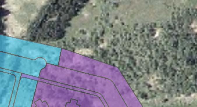


25 Map Document: (N:\gisproj\BWBR\44123\map_docs\mxd\ProjectSitePlan2.mxd) 10/24/ :09:41 PM Legend Existing Facility Phase 1 Expansion Phase 2 Expansion F Feet 1 inch equals 268 feet Figure 3: Site Plan MSOP Expansion Project Moose Lake, Minnesota


26 Map Document: (N:\gisproj\BWBR\44123\map_docs\mxd\Hx_NRHP.mxd) 11/9/ :11:51 PM F Feet 1 inch equals 700 feet Legend Historic District Boundary Area of Expansion Figure 4: National Register of Historic Place Property MSOP Expansion Project Moose Lake, Minnesota
27 Attachment 2 Natural Heritage and Nongame Research Program Correspondence

28

29
30

31
32
33
34
35
36
37
38
39
40
41

42

43
Environmental Information Worksheet
 Environmental Information Worksheet Water System Owner (Attach additional sheets if necessary) Needs and Alternatives Provide a brief narrative that describes: Current drinking water system needs. Project
STATE OF MINNESOTA MINNESOTA POLLUTION CONTROL AGENCY FINDINGS OF FACT
 STATE OF MINNESOTA MINNESOTA POLLUTION CONTROL AGENCY IN THE MATTER OF THE DECISION ON THE NEED FOR AN ENVIRONMENTAL IMPACT STATEMENT FOR THE PROPOSED LESTER PRAIRIE WASTEWATER TREATMENT FACILITY EXPANSION
STATE OF MINNESOTA MINNESOTA POLLUTION CONTROL AGENCY
 STATE OF MINNESOTA MINNESOTA POLLUTION CONTROL AGENCY In the Matter of the Decision on the Need for an Environmental Impact Statement for the Proposed Remer Wastewater Treatment Facility Expansion FINDINGS
ENVIRONMENTAL ASSESSMENT WORKSHEET
 ENVIRONMENTAL ASSESSMENT WORKSHEET Note to reviewers: The Environmental Assessment Worksheet (EAW) provides information about a project that may have the potential for significant environmental effects.
STATE OF MINNESOTA MINNESOTA POLLUTION CONTROL AGENCY FINDINGS OF FACT
 p-ear2-44b STATE OF MINNESOTA MINNESOTA POLLUTION CONTROL AGENCY IN THE MATTER OF THE DECISION ON THE NEED FOR AN ENVIRONMENTAL IMPACT STATEMENT FOR THE PROPOSED RANDY S SANITATION TRANSFER FACILITY PROPOSED
STATE OF MINNESOTA MINNESOTA POLLUTION CONTROL AGENCY FINDINGS OF FACT. Project Description
 STATE OF MINNESOTA MINNESOTA POLLUTION CONTROL AGENCY IN THE MATTER OF THE DECISION ON THE NEED FOR AN ENVIRONMENTAL IMPACT STATEMENT FOR THE PROPOSED STEMMER RIDGE ROAD TRUNK SANITARY SEWER EXTENSION
Le Sueur, Minnesota St. Paul, Minnesota Citizen Petition
 ENVIRONMENTAL ASSESSMENT WORKSHEET Note to reviewers: The Worksheet (EAW) provides information about a project that may have the potential for significant environmental effects. This EAW was prepared by
Florida Department of Environmental Protection. Bureau of Mining and Minerals Regulation. Regulation of Mines. Howard J. Hayes, Program Administrator
 Florida Department of Environmental Protection Bureau of Mining and Minerals Regulation Regulation of Mines Howard J. Hayes, Program Administrator April 2011 What is a mine? Nonphosphate mine: Subsections
PLANNING COMMISSION STAFF REPORT. Utah Crew Rowing Dock Conditional Use 830 S. Delong Street September 8, 2010 Petition #PLNPCM
 PLANNING COMMISSION STAFF REPORT Utah Crew Rowing Dock Conditional Use 830 S. Delong Street September 8, 2010 Petition #PLNPCM2010-00449 Planning Division Department of Community and Economic Development
COON CREEK WATERSHED DISTRICT PERMIT REVIEW. Spring Lake Park Schools Westwood Middle School st Avenue NE, Spring Lake Park, MN 55432
 PAN 16-112, Westwood Middle School, Page 1 of 6 COON CREEK WATERSHED DISTRICT PERMIT REVIEW MEETING DATE: August 22, 2016 AGENDA NUMBER: 10 FILE NUMBER: 16-112 ITEM: Westwood Middle School RECOMMENDATION:
Chapter 10 Natural Environment
 Chapter 10 Natural Environment Existing Conditions The Natural Environment Element addresses the protection, conservation, preservation, and restoration of the natural resources the Bayview Ridge Subarea,
Module 1: Construction Site Erosion Control
 Module 1: Construction Site Erosion Control Problems and Regulations Robert Pitt Department of Civil and Environmental Engineering University of Alabama Tuscaloosa, AL Problems Associated with Erosion
SOUTH FLORIDA WATER MANAGEMENT DISTRICT. Question 13: Wetlands
 SOUTH FLORIDA WATER MANAGEMENT DISTRICT Question 13: Wetlands 1. The wetland responses and topographical data provided in the ADA for the 520- acre project site are conceptual in nature. The referenced
CHAPTER 6 ADDITIONAL STANDARDS APPLYING TO SHORELAND AREAS AND PUBLIC WATERS
 CHAPTER 6 ADDITIONAL STANDARDS APPLYING TO SHORELAND AREAS AND PUBLIC WATERS Section 1 Intent. 49 Section 2 Floodplain Requirements 49 Section 3 Water-Oriented Accessory Structures 50 Section 4 Stairways,
Environment & Conservation Introduction
 Environment & Conservation Introduction Anacortes is blessed with an abundance of natural beauty. Residents identify marine shorelines, streams, lakes, forested areas, and other natural features as defining
STATE ENVIRONMENTAL POLICY ACT (SEPA) CHECKLIST INTAKE CHECKLIST
 CHECKLIST INTAKE CHECKLIST") Skamania County Community Development Department Building/Fire Marshal Environmental Health Planning Skamania County Courthouse Annex Post Office Box 1009 Stevenson, Washington 98648 Phone: 509-427-3900
Skamania County Community Development Department Building/Fire Marshal Environmental Health Planning Skamania County Courthouse Annex Post Office Box 1009 Stevenson, Washington 98648 Phone: 509-427-3900
Chapter 516 Shoreland Districts
 Chapter 516 Shoreland Districts 516.01 Statutory Authorization The State of Minnesota in Minnesota Statutes, Chapter 103F, has defined shoreland areas and described limitations on uses and locations of
ENVIRONMENTAL ASSESSMENT WORKSHEET
 ENVIRONMENTAL ASSESSMENT WORKSHEET Note to reviewers: The Environmental Assessment Worksheet (EAW) provides information about a project that may have the potential for significant environmental effects.
ENVIRONMENT ACT TERMS OF REFERENCE NOVA SCOTIA DEPARTMENT OF TRANSPORTATION AND PUBLIC WORKS. Beaver Bank Bypass
 ENVIRONMENT ACT TERMS OF REFERENCE NOVA SCOTIA DEPARTMENT OF TRANSPORTATION AND PUBLIC WORKS Beaver Bank Bypass Highway 101 to the Beaver Bank Road Halifax County, NS NOVA SCOTIA DEPARTMENT OF THE ENVIRONMENT
TES Industrial Development SW ¼ SEC Lacombe County Outline Plan
 TES Industrial Development Lacombe County Outline Plan 112849297 June 2012 am v:\1128\active\112849297\07_reports_studies\rpt_tes_20120508.doc i Table of Contents 1.0 INTRODUCTION... 1 1.1 PURPOSE... 1
TABLE OF CONTENTS 4.17 UTILITIES AND SERVICE SYSTEMS...
 TABLE OF CONTENTS 4.17 UTILITIES AND SERVICE SYSTEMS... 4.17-1 4.17.0 Introduction... 4.17-1 4.17.1 Methodology... 4.17-2 4.17.2 Existing Conditions... 4.17-2 4.17.3 Impacts... 4.17-4 4.17.4 Applicant-Proposed
Appendix J. Clean Water Nashville Overflow Abatement Program GUIDANCE FOR DESIGN PERMIT INFORMATION. Version 3.0
 Appendix J Clean Water Nashville Overflow Abatement Program GUIDANCE FOR DESIGN PERMIT INFORMATION Version 3.0 April 2015 Table of Contents Section 1 General Information... 1 Section 2 State of Tennessee
STATE OF MINNESOTA MINNESOTA POLLUTION CONTROL AGENCY FINDINGS OF FACT
 STATE OF MINNESOTA MINNESOTA POLLUTION CONTROL AGENCY IN THE MATTER OF THE DECISION ON THE NEED FOR AN ENVIRONMENTAL IMPACT STATEMENT FOR THE PROPOSED ROYALTON WASTEWATER TREATMENT FACILITY EXPANSION ROYALTON
STORMWATER RUNOFF AND WATER QUALITY IMPACT REVIEW
 SUBCHAPTER 8 STORMWATER RUNOFF AND WATER QUALITY IMPACT REVIEW 7:45-8.1 Purpose and scope of review Except for those projects expressly exempted by this chapter or waived by the Commission, the Commission
RE: Olmsted Waste-to-Energy Facility: MWC Unit 3 Project Environmental Impact Statement
 July 4, 2005 TO: INTERESTED PARTIES RE: : MWC Unit 3 Project Environmental Impact Statement An Environmental Impact Statement (EIS) is being prepared by the Minnesota Pollution Control Agency (MPCA) on
52 North Broadway DEIS Scoping Outline
 Introduction WP Development NB, LLC (the Applicant ) proposes to redevelop the former Good Counsel site, of which it is the owner, in White Plains, NY with residential uses in a campus-like setting (the
IV. ENVIRONMENTAL IMPACT ANALYSIS G. HYDROLOGY/WATER QUALITY
 IV. ENVIRONMENTAL IMPACT ANALYSIS G. HYDROLOGY/WATER QUALITY ENVIRONMENTAL SETTING The project site is located in the Wilshire community of the City of Los Angeles and is bound by S. Wetherly Drive to
SP Old Florida Investment Resources, LLC SMR Aggregates SR 64 Borrow Pit (DTS # )
") H.O. 03/24/14 SP-14-01 Old Florida Investment Resources, LLC SMR Aggregates SR 64 Borrow Pit (DTS #201400001) Request: Approval of a Special Permit for major earthmoving in the A (General Agriculture)
H.O. 03/24/14 SP-14-01 Old Florida Investment Resources, LLC SMR Aggregates SR 64 Borrow Pit (DTS #201400001) Request: Approval of a Special Permit for major earthmoving in the A (General Agriculture)
STATE OF MINNESOTA MINNESOTA POLLUTION CONTROL AGENCY FINDINGS OF FACT
 p-ear2-59b STATE OF MINNESOTA MINNESOTA POLLUTION CONTROL AGENCY IN THE MATTER OF THE DECISION ON THE NEED FOR AN ENVIRONMENTAL IMPACT STATEMENT FOR THE PROPOSED HEARTLAND HUTTERIAN BRETHREN, INC. FEEDLOT
(For individual lake and stream classifications in Cook County, refer to Appendix II)
") Article 7 Sec. 7.01 Shoreland Management Regulations Policy The uncontrolled use of shorelands of Cook County, Minnesota affects the public health, safety and general welfare not only by contributing to
Article 7 Sec. 7.01 Shoreland Management Regulations Policy The uncontrolled use of shorelands of Cook County, Minnesota affects the public health, safety and general welfare not only by contributing to
Chapter 3 Affected Environment and Environmental Consequences
 Sterling Highway MP 45 60 Draft SEIS and Draft Section 4(f) Evaluation Chapter 3 Affected Environment and Environmental Consequences Prepared for: Alaska Department of Transportation and Public Facilities
ENVIRONMENTAL RESOURCE PERMIT APPLICATION
 ENVIRONMENTAL RESOURCE PERMIT APPLICATION SOUTHWEST FLORIDA WATER MANAGEMENT DISTRICT 2379 BROAD STREET, BROOKSVILLE, FL 34604-6899 (352) 796-7211 OR FLORIDA WATS 1 (800) 423-1476 SECTION E INFORMATION
Department of the Army Permit Application
 Department of the Army Permit Application DA File Number U.S. Army Corps of Engineers Honolulu District Date Received by CEPOH-RO Send Completed Application to: Honolulu District, U.S. Army Corps of Engineers
Public Notice ISSUED: March 14, 2018 EXPIRES: April 13, 2018
 APPLICANT: REFER TO: Wellington Management, Inc. 2004-04510-BBY Public Notice ISSUED: March 14, 2018 EXPIRES: April 13, 2018 SECTION:404 - Clean Water Act 1. APPLICATION FOR PERMIT TO discharge fill material
FINDINGS OF FACT and CONCLUSIONS
 FINDINGS OF FACT and CONCLUSIONS TH 23 North Gap: 2-Lane to 4-Lane Conversion Project from Paynesville to Richmond State Project No. 7305-124 Prepared by: Minnesota Department of Transportation CONTENTS
Erosion & Sedimentation Control Policy
 Issue Date 10/22/2010 Page 1 of 8 Erosion & Sedimentation Control Policy Introduction: Soil erosion is the removal of soil by water, wind, ice or gravity and sediment deposition occurs when the rate of
Waste Management of Canada Corporation (WM) is pleased to welcome you to Public Open House #2 for the. Twin Creeks Landfill Environmental Screening
 is pleased to welcome you to Public Open House #2 for the. Twin Creeks Landfill Environmental Screening") Welcome Waste Management of Canada Corporation (WM) is pleased to welcome you to Public Open House #2 for the Please take a few moments to browse the display material and talk to our staff and consultants.
Welcome Waste Management of Canada Corporation (WM) is pleased to welcome you to Public Open House #2 for the Please take a few moments to browse the display material and talk to our staff and consultants.
Assessment of Landfill Footprint Alternatives West Carleton Environmental Centre. Option #4 Impact on Agriculture
 Assessment of Landfill Footprint Alternatives Figure 422 99 Option #4 Impact on Agriculture The net effects with respect to continued service to customers, the optimized site life/ capacity is 65 million
Chapter 6 Regulations and Requirements
 Chapter 6 Regulations and Requirements The information in this chapter is provided to help you comply with other Tacoma and Washington State regulations, which may apply to your project, industry or business
DRAFT FINDING OF NO SIGNIFICANT IMPACT. for. Tioga Sports Park
 DRAFT FINDING OF NO SIGNIFICANT IMPACT for Tioga Sports Park The U.S. Fish and Wildlife Service (USFWS) prepared an Environmental Assessment (EA) to analyze the potential effects of the proposal by the
National Housing Trust Fund Environmental Review and Funding Requirements
 National Housing Trust Fund Environmental Review and Funding Requirements National Housing Trust Fund grants come with their own environmental review requirements that differ slightly from the Part 58
WELCOME TO THE CONSTRUCTION STORMWATER PERMIT WEBINAR
 WELCOME TO THE CONSTRUCTION STORMWATER PERMIT WEBINAR All the documents shown today are in the MN Stormwater Manual on the page titled 2018 Construction Stormwater Permit Public Notice and Public Informational
TORCH LAKE TOWNSHIP WATER QUALITY ACTION PLAN
 TORCH LAKE TOWNSHIP WATER QUALITY ACTION PLAN Elk-River-Chain-of-Lakes Gaps Analysis Project The Watershed Center Grand Traverse Bay Tip of the Mitt Watershed Council Michigan Department of Natural Resources
Understanding Stormwater Pollution Prevention Plans (SWPPPs) (SWPPPS)
 (SWPPPS)") Understanding Stormwater Pollution Prevention Plans (SWPPPs) (SWPPPS) Definitions SWPPP: Storm Water Pollution Prevention Plan BMP: Best Management Practice(s) to control pollution IDNR: Iowa Department
Understanding Stormwater Pollution Prevention Plans (SWPPPs) (SWPPPS) Definitions SWPPP: Storm Water Pollution Prevention Plan BMP: Best Management Practice(s) to control pollution IDNR: Iowa Department
SECTION 11: REGULATORY FLOODWAYS
 SECTION 11: REGULATORY FLOODWAYS Contents 11.1. The Floodway... 11-2 11.1.1. The floodway concept... 11-2 11.1.2. Floodway map... 11-2 11.1.3. Floodway permitting... 11-3 11.1.4. Changing the floodway...
Project Overview. Northwest Innovation Works LLC and the Port of Kalama propose to develop and operate
 Project Overview Northwest Innovation Works LLC and the Port of Kalama propose to develop and operate a natural gas-tomethanol production plant and storage facilities, and a new marine terminal, in the
UNIVERSITY OF OREGON NORTH CAMPUS CONDITIONAL USE PERMIT PROJECT Draft Conditional Use Permit Stormwater, Sanitary Sewer, and Water Analysis Report
 UNIVERSITY OF OREGON NORTH CAMPUS CONDITIONAL USE PERMIT PROJECT Draft Conditional Use Permit Stormwater, Sanitary Sewer, and Water Analysis Report Prepared for: Cameron McCarthy Landscape Architects LLP
Appendix G: Source Control Mitigation Measures Intentionally Left Blank
 Appendix G: Source Control Mitigation Measures Intentionally Left Blank PLANNING AND LAND DEVELOPMENT HANDBOOK Part B: PLANNING ACTIVITIES, 5 TH ED. Source Control Measures S-1: Storm Drain Message and
Order of road works and servicing construction to be carried out in accordance with the staged contract construction sequence specified below.
 SEDIMENT CONTROL NOTES 1.0 GENERAL 1.1 The Developer and Contractor shall comply with the requirements of all regulatory authorities, federal, provincial and municipal government departments including
Forest Recreation Management
 Forest Recreation Management 1 Forest Recreation Management Introduction...3 CONTENTS The Benefits of Guidelines...3 Considerations...4 Planning...5 Construction of Recreation Areas...6 Protecting Cultural
E. STORMWATER MANAGEMENT
 E. STORMWATER MANAGEMENT 1. Existing Conditions The Project Site is located within the Lower Hudson Watershed. According to the New York State Department of Environmental Conservation (NYSDEC), Lower Hudson
State of Florida Department of Community Affairs Areas of Critical State Concern Implementation Status Report Apalachicola Bay Area
 State of Florida Department of Community Affairs Areas of Critical State Concern Implementation Status Report Apalachicola Bay Area Thaddeus L. Cohen, AIA Secretary November 2006 CONTENTS Part 1 - Summary
Characteristics of Land Resources
 Chapter Chapter 1 Characteristics of Land Resources The geology, soils and topography of Woodford County T he geology, soils and topography of an area are important to the community planning process for
Wetland Permit Application
 DAVID J. KLOTZLE WETLAND INSPECTOR, PHILIPSTOWN, NY 238 Main Street Cold Spring, NY 10516 (914) 736-7132 Wetland Permit Application MEMO TO APPLICANT 1. Use this form to apply for a Wetlands Permit as
Notwithstanding article VII of this chapter, the following conditional uses may be permitted in the planned mixed use development (PMUD) zone:
 zone:") DIVISION 14. - PLANNED MIXED USE DEVELOPMENT (PMUD) Sec. 78-1021. - Purpose. The town is a community with a rich tradition of mixed use neighborhoods and a paucity of land area dedicated for large commercial,
DIVISION 14. - PLANNED MIXED USE DEVELOPMENT (PMUD) Sec. 78-1021. - Purpose. The town is a community with a rich tradition of mixed use neighborhoods and a paucity of land area dedicated for large commercial,
GUIDE TO THE DEVELOPMENT OF A MINING AND RECLAMATION PLAN IN NEW BRUNSWICK
 PROVINCE OF NEW BRUNSWICK DEPARTMENT OF ENERGY AND RESOURCE DEVELOPMENT Minerals and Petroleum Development Branch GUIDE TO THE DEVELOPMENT OF A MINING AND RECLAMATION PLAN IN NEW BRUNSWICK Guide to the
ADMINISTRATIVE HEARING STAFF REPORT
 ADMINISTRATIVE HEARING STAFF REPORT Salt Lake City Water Treatment Facility 1365 West 2300 North CONDITIONAL USE Case #PLNPCM2013-00762 December 12, 2013 Planning and Zoning Division Department of Community
Chapter 9 Wetlands Park Study Team
 Chapter 9 Wetlands Park Study Team Objective How can we help Clark County facilitate implementation of the Clark County Wetlands Park Master Plan, and provide for the management of various ecosystems within
901 STORMWATER POLLUTION MANAGEMENT SECTION 901 STORMWATER POLLUTION MANAGEMENT
 SECTION 901 STORMWATER POLLUTION MANAGEMENT 901.1 DESCRIPTION Design, implement, inspect and maintain appropriate best management practices to minimize or eliminate erosion, sediment and other pollutants
PUBLIC NOTICE. Section 404 of the Clean Water Act (33 U.S.C. 1344) Section 10 of the Rivers and Harbors Act of 1899 (33 U.S.C.
 Section 10 of the Rivers and Harbors Act of 1899 (33 U.S.C.") US Army Corps Of Engineers Wilmington District PUBLIC NOTICE Issue Date: June 17, 2014 Comment Deadline: July 17, 2014 Corps Action ID#: SAW-2009-00655 NC DOT TIP: R-4903 The Wilmington District, Corps
US Army Corps Of Engineers Wilmington District PUBLIC NOTICE Issue Date: June 17, 2014 Comment Deadline: July 17, 2014 Corps Action ID#: SAW-2009-00655 NC DOT TIP: R-4903 The Wilmington District, Corps
actions and approvals by the Federal Aviation Administration ( FAA) and the Federal
 and the Federal") METROPOLITAN AIRPORTS COMMISSION In re MSP 2020 Improvements Final Environmental Assessment/Environmental Assessment Worksheet, Adequacy Determination, and Negative Declaration on the Need for an Environmental
METROPOLITAN AIRPORTS COMMISSION In re MSP 2020 Improvements Final Environmental Assessment/Environmental Assessment Worksheet, Adequacy Determination, and Negative Declaration on the Need for an Environmental
STORMWATER DISCHARGES ASSOCIATED WITH CONSTRUCTION ACTIVITY
 STATE OF COLORADO GENERAL PERMIT APPLICATION Updated 11/04 STORMWATER DISCHARGES ASSOCIATED WITH CONSTRUCTION ACTIVITY This application is for use by all stormwater dischargers engaged in construction
Annex F Scoping Checklist
 Scoping Checklist Table F1: Scoping Checklist Table. Questions to be considered in Scoping /? Which Characteristics of the Project 1. Will construction, operation or decommissioning of the Project involve
Chapter 21 Stormwater Management Bylaw
 Chapter 21 Stormwater Management Bylaw SECTION 1. PURPOSE The purpose of this Bylaw is to: implement the requirements of the National Pollutant Discharge Elimination System (NPDES) General Permit for Storm
5.0 PROJECT ALTERNATIVES
 5.0 ALTERNATIVES 5.1 INTRODUCTION GENERAL CEQA REQUIREMENTS California Environmental Quality Act (CEQA) Guidelines Section 15126.6(a) states an EIR shall describe a range of reasonable alternatives to
S.O.P. No. HMD
 Page: 1 of 9 PURPOSE: To establish (SOP) for submission requirements, review process and approval of applications for Non-vehicular Access Permits for the purpose of connection or discharge to any MassDOT
WHATCOM COUNTY STANDARD FARM CONSERVATION PLAN PLANNING WORKBOOK: Checklist and Action Plan
 WHATCOM COUNTY STANDARD FARM CONSERVATION PLAN PLANNING WORKBOOK: Checklist and Action Plan For use with the publication: Tips on Land and Water Management For: Land Owner Address Date Introduction Conservation
Ingham County Drain Commissioner Patrick E. Lindemann 707 BUHL AVENUE P. O. BOX 220 MASON MI PH. (517) FAX (517)
 FAX (517)") Date Issued Ingham County Drain Commissioner Patrick E. Lindemann 707 BUHL AVENUE P. O. BOX 220 MASON MI 48854 PH. (517) 676-8395 FAX (517) 676-8364 APPLICATION FOR SOIL EROSION AND SEDIMENTATION POLLUTION
Date Issued Ingham County Drain Commissioner Patrick E. Lindemann 707 BUHL AVENUE P. O. BOX 220 MASON MI 48854 PH. (517) 676-8395 FAX (517) 676-8364 APPLICATION FOR SOIL EROSION AND SEDIMENTATION POLLUTION
DEPARTMENT OF ENVIRONMENTAL PROTECTION BUREAU OF MINING AND RECLAMATION. Coal Refuse Disposal - Site Selection
 DEPARTMENT OF ENVIRONMENTAL PROTECTION BUREAU OF MINING AND RECLAMATION DOCUMENT NUMBER: 563-2113-660 TITLE: Coal Refuse Disposal - Site Selection EFFECTIVE DATE: February 8, 1999 AUTHORITY: The Coal Refuse
NOTICE OF PREPARATION
 NOTICE OF PREPARATION Date: June 12, 2014 To: From: Subject: Governor s Office of Planning and Research/State Clearinghouse Unit, Responsible Agencies, Trustee Agencies, and Interested Parties Announcement
Town of Essex, Vermont January, 2017 Standard Specifications For Construction CHAPTER 3 EROSION AND SEDIMENT CONTROL
 CHAPTER 3 EROSION AND SEDIMENT CONTROL CHAPTER 3 EROSION AND SEDIMENT CONTROL Section 300 General Summary All projects constructed within the Town of Essex shall be constructed in strict accordance with
Noront Ferrochrome Production Facility (FPF) Environmental Issues and Approach. October 2017
 Environmental Issues and Approach. October 2017") Noront Ferrochrome Production Facility (FPF) Environmental Issues and Approach October 2017 (Simulated FPF) INTRODUCTION Noront is proposing to develop a Ferrochrome Production Facility (FPF) in Northern
Noront Ferrochrome Production Facility (FPF) Environmental Issues and Approach October 2017 (Simulated FPF) INTRODUCTION Noront is proposing to develop a Ferrochrome Production Facility (FPF) in Northern
Blanche Park Reservoir Decision Notice and Finding of No Significant Impact
 Blanche Park Reservoir Decision Notice and Finding of No Significant Impact U.S. Forest Service Grand Mesa, Uncompahgre, and Gunnison National Forests Delta County, Colorado INTRODUCTION The Grand Mesa
VEGETATIVE, WATER, FISH AND WILDLIFE RESOURCES POLICIES
 VEGETATIVE, WATER, FISH AND WILDLIFE RESOURCES POLICIES The County will: GOALS AND OBJECTIVES 1.1 Conserve, Enhance, Protect, Maintain and Manage Vegetative, Water, Fish and Wildlife Resources Promote
Feedlot Construction Setbacks from Open Water and Wells
 Feedlot Construction Setbacks from Open Water and Wells Water Quality/Feedlots #8.30 May 2009 Contents New and expanded feedlots near waters... 2 Setbacks from wells... 3 Public water supply wells... 4
901 - TEMPORARY EROSION AND POLLUTION CONTROL SECTION 901 TEMPORARY EROSION AND POLLUTION CONTROL
 SECTION 901 TEMPORARY EROSION AND POLLUTION CONTROL 901.1 DESCRIPTION Install, maintain and remove temporary erosion and pollution control devices as required during the construction of the project. BID
Zoning Permits 11-1 ZONING PERMITS
 Zoning Permits 11-1 ZONING PERMITS (a) Building or structures shall be started, repaired, reconstructed, enlarged or altered only after a zoning permit has been obtained from the administrator and a building
City of Fairmont Storm Water Pollution Prevention Plan (SWPPP) January 23, 2017
 January 23, 2017") City of Fairmont Storm Water Pollution Prevention Plan (SWPPP) January 23, 2017 Why is Water Quality Important? Water has always been important to Minnesota and is a key part of our history, culture, economy
City of Fairmont Storm Water Pollution Prevention Plan (SWPPP) January 23, 2017 Why is Water Quality Important? Water has always been important to Minnesota and is a key part of our history, culture, economy
BIG ROCHE A CRI LAKE CHARACTERISTICS
 BIG ROCHE A CRI LAKE CHARACTERISTICS Lake Description Big Roche Cri Lake is located in north central Adams County and has a surface area of 205 acres, a shoreline length of 6.1 mile, a volume of 6,993
Chapter 13: Wildlife and Vegetation
 Chapter 13: Wildlife and Vegetation Introduction and Setting Nevada County contains an extremely wide range of plants, animals and habitat types. With topographic elevations ranging from 300 feet in the
BMPs TO CONSERVE WOODED AREAS AT THE SUBDIVISION LEVEL
 BMPs to Conserve Wooded Areas 31 BMPs TO CONSERVE WOODED AREAS AT THE SUBDIVISION LEVEL Audience This section is primarily directed toward: local units of government, landowners and developers, builders
POLLUTION PREVENTION AFTER CONSTRUCTION
 POLLUTION PREVENTION AFTER CONSTRUCTION..CHAPTER.. 10 This chapter describes the pollution prevention measures to be taken once the site has been permanently and finally stabilized and no additional construction
Submitted to: Mr. Jim Dunn Chesterfield County Economic Development Department 9401 Courthouse Road - Suite B Chesterfield, VA 23830
 THE TIMMONS REPORT Draft Executive Summary of Preliminary Engineering, Environmental and Master Planning Report for Meadowville Technology Park Chesterfield County, Virginia Submitted to: Mr. Jim Dunn
Factor Potential Effects Mitigation Measures
 Natural Environment No impacts of provincial significance to the natural environment are anticipated for the rapid transit project. Other impacts and how they will be mitigated are outlined in the table
SECTION 3 NATURAL RESOURCES
 SECTION 3 NATURAL RESOURCES The natural environment plays a large role in planning for future development. Environmental conditions, such as topography, wetlands, floodplains, and water bodies, can often
County of Calaveras Department of Planning
 Date: July 18, 2013 To: From: Project: Advisory Agencies Amy Augustine, AICP - Planner County of Calaveras Department of Planning Rebecca L. Willis, AICP ~ Planning Director Phone (209) 754-6394 Fax (209)
ARTICLE XII RECREATIONAL VEHICLE PARK REGULATIONS
 ARTICLE XII RECREATIONAL VEHICLE PARK REGULATIONS ARTICLE XII RECREATIONAL VEHICLE PARK REGULATIONS Section 1201 Applicability For the purpose of this Article, recreation vehicles and recreational vehicle
Construction Best Management Practices Handbook BEST MANAGEMENT PRACTICES
 Construction Best Management Practices Handbook www.montereysea.org BEST MANAGEMENT PRACTICES 26 www.montereysea.org Construction Best Management Practices Handbook VEHICLE TRACKING AND DUST CONTROL IN
October 19, 2017 Community Engagement Panel Meeting #4 Overview of Environmental Effects
 Lake Elmo Airport Environmental Assessment (EA)/ Environmental Assessment (EAW) Worksheet October 19, 2017 Community Engagement Panel Meeting #4 Overview of Environmental Effects Agenda Public Event #2
UC SANTA CRUZ EROSION AND SEDIMENT CONTROL STANDARDS FOR PROJECTS UNDER ONE ACRE
 CAMPUS STANDARDS APPENDIX D UC SANTA CRUZ EROSION AND SEDIMENT CONTROL STANDARDS FOR PROJECTS UNDER ONE ACRE July 9, 2012 UCSC Campus Standards Handbook Erosion and Sediment Control Standards Appendix
Ponds. Pond A water impoundment made by excavating a pit, or constructing a dam or an embankment.
 POND SITE SELECTION AND CONSTRUCTION Uses, Planning, & Design David Krietemeyer Area Engineer USDA-NRCS June 20, 2008 Uses Considerations for Location of Commonly Used Terms Pond A water impoundment made
ENVIRONMENTAL INFORMATION FORM
 ENVIRONMENTAL INFORMATION FORM City of Fontana Planning Division The purpose of this form is to inform the city of the basic components of the proposed project so that the City may review the project pursuant
Chapter 2 ADMINISTRATIVE PROCEDURES
 Chapter 2 2.01 General 2.01.1 Application of Chapter 2.01.2 Fees 2.02 Pre-Development Site Certification and Assessment 2.03 Construction Permits 2.03.1 Site Development Permit 2.03.2 Development Permits
DAKOTA COUNTY SOIL AND WATER CONSERVATION DISTRICT COMPREHENSIVE PLAN
 DAKOTA COUNTY SOIL AND WATER CONSERVATION DISTRICT COMPREHENSIVE PLAN 2011-2015 4100 220 th Street West, Suite 102 Farmington, MN 55024 651-480-7777 www.dakotacountyswcd.org I. INTRODUCTION A. Purpose
GLENN COUNTY Planning & Public Works Agency
 GLENN COUNTY Planning & Public Works Agency P.O. Box 1070 / 777 N. Colusa Street Willows, CA 95988 530.934.6530 Fax 530.934.6533 www.gcppwa.net MEETING DATE: October 21, 2015 REPORT DATE: September 17,
PRELIMINARY DRAINAGE REPORT NEWCASTLE FIRE STATION OLD STATE HIGHWAY
 PRELIMINARY DRAINAGE REPORT FOR THE NEWCASTLE FIRE STATION OLD STATE HIGHWAY PREPARED FOR THE NEWCASTLE FIRE PROTECTION DISTRICT JULY 2014 BY ROSEVILLE DESIGN GROUP, INC. ROSEVILLE DESIGN GROUP, Inc Established
VILLAGE OF BELLAIRE WATER QUALITY ACTION PLAN
 VILLAGE OF BELLAIRE WATER QUALITY ACTION PLAN Elk-River-Chain-of-Lakes Gaps Analysis Project The Watershed Center Grand Traverse Bay Tip of the Mitt Watershed Council Michigan Department of Natural Resources
LAND USE PBF LDR ZONING PUD PUD. Proposed Maximum Density (DU/Acre) Existing Maximum Intensity (FAR) .30 FAR/ 173 dwelling units.
 Existing Maximum Intensity (FAR) .30 FAR/ 173 dwelling units.") PROPOSED LARGE SCALE FUTURE LAND USE MAP (FLUM) AMENDMENT OVERVIEW ORDINANCE: 2013-658 APPLICATION: 2013G-001-3-5 APPLICANT: PAUL HARDEN PROPERTY LOCATION: On the south side of Sunbeam Road, at the terminus
PROPOSED LARGE SCALE FUTURE LAND USE MAP (FLUM) AMENDMENT OVERVIEW ORDINANCE: 2013-658 APPLICATION: 2013G-001-3-5 APPLICANT: PAUL HARDEN PROPERTY LOCATION: On the south side of Sunbeam Road, at the terminus
SECTION V CHAPTER 12 STORMWATER POLLUTION PREVENTION POLICY
 1. PURPOSE: SECTION V CHAPTER 12 STORMWATER POLLUTION PREVENTION POLICY The purpose of this policy is to establish procedures to facilitate compliance with federal, state and local stormwater regulations
H2. Residential Rural and Coastal Settlement Zone
 H2. Residential Rural and Coastal Settlement Zone H2.1. Zone description The Residential Rural and Coastal Settlement Zone applies to rural and coastal settlements in a variety of environments including