Barkley L&D U.S. ARMY CORPS OF BUILDING STRONG ENGINEERS
|
|
|
- Poppy Barrett
- 5 years ago
- Views:
Transcription
1 Barkley L&D U.S. ARMY CORPS OF BUILDING STRONG ENGINEERS 2016 Quick Facts Commercial Lock Operations - 1,296 National Rank Short Tons (Thousands) - 7,248 National Rank - 84 Commodity Value (Millions) - $ Average Tow Delay (HH:MM:SS) - 03:16:52 Source: USACE WCS, Values estimated from 2012 NDSU Commodity Valuation Study, indexed to 2016 price level(commodity dollar values are not calculated for foreign movements) ** Remaining 4.49% Unable to release due to insufficient operators
2 Lock Information Barkley Lock is located 30.6 river miles from where the Cumberland River joins the Ohio River at Smithland, Kentucky. The nearest community to the lock is Grand Rivers, Kentucky. Barkley Lock was opened to navigation traffic in July of The lock chamber is 800-foot long and 110-foot wide. During normal lake levels, the lock will lift a boat 57-foot from the river below the dam to the lake above the dam. The lock releases over 37.5 million gallons of water each time is emptied. Barkley Lock is open to pass navigation traffic 20 hours-a-day, 365 days a year. The lock is closed between the hours of 2 and 6 a.m. daily. Barkley Lock is named for Alben W. Barkley. Alben Barkley was born in Graves County in Western Kentucky in He began practicing Law in Paducah, Kentucky in In 1913, he was elected to Congress, where he served until He was elected to the Senate in 1927 and served until 1948 when he was elected Vice President of the United States on the Democratic ticket with Harry S. Truman. After leaving the Vice Presidency in 1953, he returned to the U.S. Senate in 1955 where he served until his death in 1956.
3
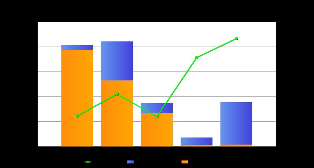
4 Commodity Group Avg Tonnage % of Total Tons Five Year Commodity Trend (Millions of Tons) Aggregates 698,261 10% Chemicals 70,069 1% Coal 5,211,983 75% Crude Petroleum ** ** Grains 363,053 5% Iron/Steel 182,021 3% Ores/Minerals 32,288 <1% Others 225,478 3% Petroleum 155,266 2% Source: Waterborne Commerce Statistics **-Year = Insufficient Operators to Release Tonnage

5

,2012 NDSU Commodity Value Study (Commodity")
6 Braddock L&D U.S. ARMY CORPS OF BUILDING STRONG ENGINEERS 2016 Quick Facts Commercial Lock Operations - 2,687 National Rank - 60 Short Tons (Thousands) - 11,106 National Rank - 69 Commodity Value (Millions) - Unable to Release Average Tow Delay (HH:MM:SS) - 00:20:17 Source: Lock Performance Monitoring System (lockages and Tons),2012 NDSU Commodity Value Study (Commodity Value),Waterborne Commerce Statistics (Commodity Tonnage Below) ** Remaining 0.31% Unable to release due to insufficient operators
7 Lock Information Location: Braddock Locks and Dam is one of nine navigation structures which provide for year-round navigation on the Monongahela River between Pittsburgh, PA and Fairmont, West Virginia. It maintains a pool for 12.6 miles upstream to Locks and Dam 3 at Elizabeth, PA. Braddock Locks and Dam is located at Monongahela River mile 11.2 at the city of Braddock, PA. The lock chambers and operations buildings are situated along the right bank of the river adjacent to a major steel-making plant. Road access to the project is from 11th Street in Braddock. History: Construction of Locks and Dam 2 at this present site was begun in 1902 and completed in After some 40 years of use, a major rehabilitation of the project was completed in This work involved reconstruction and enlargement of the lock chambers and adjustment of the length of the dam.
8
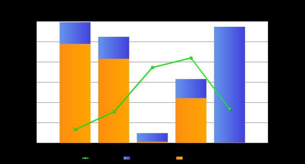
9 Commodity Group Avg Tonnage % of Total Tons Five Year Commodity Trend (Millions of Tons) Aggregates 1,444,201 11% Chemicals 213,815 2% Coal 11,042,481 81% Grains ** ** Iron/Steel 263,492 2% Ores/Minerals 269,971 2% Others 33,623 <1% Petroleum 337,475 2% Source: Waterborne Commerce Statistics **-Year = Insufficient Operators to Release Tonnage

10
 - 825 National Rank - 135 Commodity Value (Millions) - $378.")
11 Chickamauga L&D U.S. ARMY CORPS OF BUILDING STRONG ENGINEERS 2016 Quick Facts Commercial Lock Operations National Rank Short Tons (Thousands) National Rank Commodity Value (Millions) - $ Average Tow Delay (HH:MM:SS) - 01:18:08 Source: USACE WCS, Values estimated from 2012 NDSU Commodity Valuation Study, indexed to 2016 price level(commodity dollar values are not calculated for foreign movements) ** Remaining 19.51% Unable to release due to insufficient operators
12 Lock Information Location Chickamauga Lock is located at Tennessee River mile 471 only 6.9 miles above Chattanooga, Tennessee. It is 58.9 river miles downstream of Watts Bar Lock and 46.3 miles upriver from Nickajack Lock. Lock History TVA commenced preliminary investigation for the Chickamauga project during May 1935, and the Board of Directors authorized its construction on Dec. 31, Construction of the Chickamauga project started in Jan. 13, 1936 and was opened to navigation in The name Chickamauga came from a warlike tribe of Chickamauga Indians, who had separated from the main body of the Cherokee Indians. The band was a mix of Cherokee and Creek warriors, white fugitives, and some African Americans who collectively took the name Chickamauga The Chickamauga lived in a village nearly a mile in length on Chickamauga Creek several miles above the mouth. According to Mr. John P. Long in his history of Hamilton County, Chickamauga means dull, sluggish stream. Concrete Growth Chickamauga Lock has growing concrete in it's structure, which is a reaction between the alkali in the cement and the minerals in the stone. This growing concrete has brought many problems ±in some places large chunks of concrete have broken loose from the lock walls ±and because the massive blocks that make up the lock have expanded at different rates, the top of the structure is uneven. Lengthwise, the lock has actually grown five inches inside the lock chamber. The approach walls have grown even more. Corps of Engineers and TVA working together continues making temporary repairs to the project spending large maintenance dollars. Corps and TVA have determined that Chickamauga Lock does have a finite life.
13
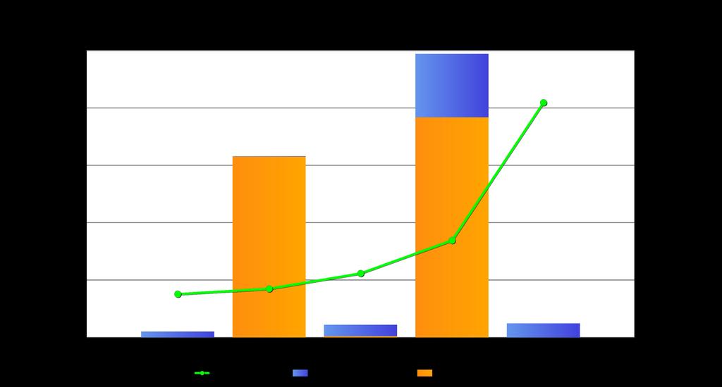
14 Commodity Group Avg Tonnage % of Total Tons Five Year Commodity Trend (Millions of Tons) Aggregates ** ** Chemicals 75,458 9% Coal ** ** Grains 56,470 6% Iron/Steel 95,323 11% Ores/Minerals 492,199 56% Others 43,678 5% Petroleum 85,776 10% Source: Waterborne Commerce Statistics **-Year = Insufficient Operators to Release Tonnage
15
 - 9,677 National Rank - 68 Commodity Value (Millions) - $1,714.")
16 Emsworth L&D U.S. ARMY CORPS OF BUILDING STRONG ENGINEERS 2016 Quick Facts Commercial Lock Operations - 3,457 National Rank - 45 Short Tons (Thousands) - 9,677 National Rank - 68 Commodity Value (Millions) - $1, Average Tow Delay (HH:MM:SS) - 01:40:59 Source: USACE WCS, Values estimated from 2012 NDSU Commodity Valuation Study, indexed to 2016 price level(commodity dollar values are not calculated for foreign movements)
17 Lock Information Location: Emsworth Locks and Dam s main channel dam is located at river mile 6 near the towns of Emsworth, Avalon and Ben Avon, PA. History: The locks first opened in September The Corps rebuilt and converted the dam to a gate structure between 1935 and This action raised the pool an additional 7 feet to accommodate larger, more modern barges. From , some $30 million was invested in a major rehabilitation of the facility. Rehabilitation included the replacement of electrical systems, operating machinery and buildings and re-surfacing of the lock walls. Project Information The Emsworth project consists of two gated dams, one of the two major types in service in the Pittsburgh District. Gated dams are constructed to permit increased control over the water level in the navigation pool upriver of the dam. Machinery mounted on tall concrete piers moves large chains which lift gates that are hinged into the body of the piers. As the gates are raised or lowered to control the amount of water flowing under them, the upstream pool is maintained at a relatively constant level for an authorized depth of at least 9 feet throughout its length. The dam, however, cannot be operated to control flood flows. An incidental benefit derived from the pool formed by the dam is the availability of a source of municipal and industrial water.
18
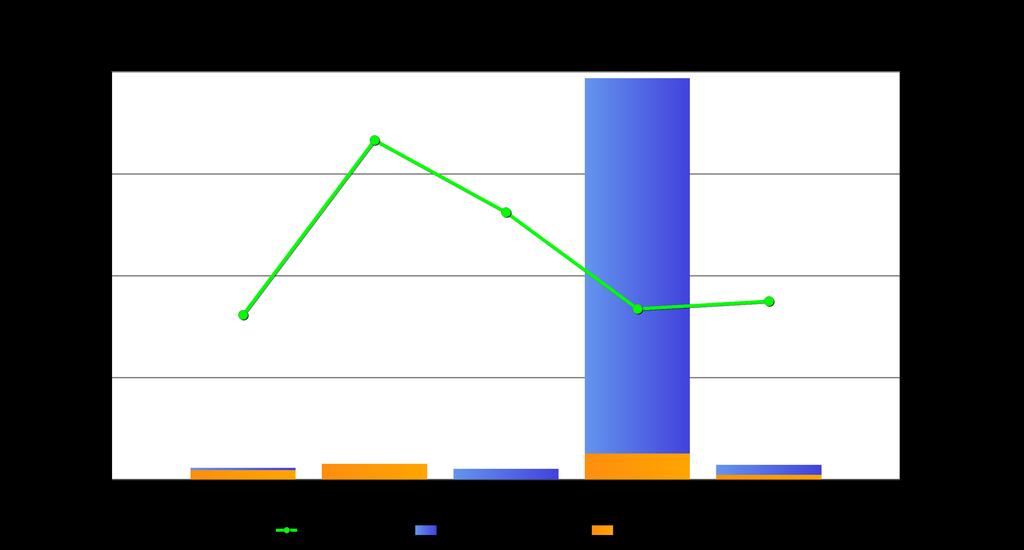
19 Commodity Group Avg Tonnage % of Total Tons Five Year Commodity Trend (Millions of Tons) Aggregates 1,265,350 8% Chemicals 327,375 2% Coal 11,573,047 77% Grains ** ** Iron/Steel 401,083 3% Ores/Minerals 458,093 3% Others 250,677 2% Petroleum 719,576 5% Source: Waterborne Commerce Statistics **-Year = Insufficient Operators to Release Tonnage
20
 - 10,378 National Rank - 62 Commodity Value (Millions) - $7,834.")
21 Inner Harbor Lock U.S. ARMY CORPS OF BUILDING STRONG ENGINEERS 2016 Quick Facts Commercial Lock Operations - 5,355 National Rank - 19 Short Tons (Thousands) - 10,378 National Rank - 62 Commodity Value (Millions) - $7, Average Tow Delay (HH:MM:SS) - 17:01:09 Source: USACE WCS, Values estimated from 2012 NDSU Commodity Valuation Study, indexed to 2016 price level(commodity dollar values are not calculated for foreign movements)
22 Lock Information Location The IHNC Lock is located in the Industrial Canal which runs through a highly urbanized area within the New Orleans city limits. It joins Lake Pontchartrain to the north with the Mississippi River to the south. The canal also connects the eastern segment of the Gulf Intracoastal Waterway (GIWW) with the Mississippi River. On January 6, 2017, the U.S. Army Corps of Engineers released the ³Mississippi River, Baton Rouge to the Gulf of Mexico Mississippi River-Gulf Outlet, Louisiana, New Industrial Canal Lock and Connecting Channels Project Draft Integrated General Reevaluation Report (GRR) and Draft Supplemental Environmental mpact Statement (SEIS) for public review. In addition to documenting significant changes in the area since the initial feasibility study and environmental impact statement was completed in 1997, this report proposes replacement of the 95 year-old Inner Harbor Navigation Canal (IHNC) lock with a new lock. The draft tentatively selected plan proposes replacement of the existing lock with a new shallow-draft lock having usable dimensions of 900 feet long by 110 feet wide by 22 feet deep to be constructed between the banks of the IHNC, north of the existing lock.
23
24 Commodity Group Avg Tonnage % of Total Tons Five Year Commodity Trend (Millions of Tons) Aggregates 1,384,853 9% Chemicals 3,480,503 24% Coal 246,758 2% Crude Petroleum 2,414,848 16% Grains 101,298 <1% Iron/Steel 1,982,649 13% Ores/Minerals 286,568 2% Others 1,017,425 7% Petroleum 3,885,568 26% Source: Waterborne Commerce Statistics

25

 - 09:28:19 Source: USACE WCS, Values estimated from 2012 NDSU Commodity Valuation Study,")
26 Kentucky L&D U.S. ARMY CORPS OF BUILDING STRONG ENGINEERS 2016 Quick Facts Commercial Lock Operations - 4,399 National Rank - 27 Short Tons (Thousands) - 24,934 National Rank - 31 Commodity Value (Millions) - $6, Average Tow Delay (HH:MM:SS) - 09:28:19 Source: USACE WCS, Values estimated from 2012 NDSU Commodity Valuation Study, indexed to 2016 price level(commodity dollar values are not calculated for foreign movements) ** Remaining 2.16% Unable to release due to insufficient operators
27 Lock Information Location Kentucky Lock is located near Gilbertsville, Kentucky, 22.4 miles from the confluence of the Tennessee and Ohio Rivers. It is 20 miles east of Paducah, Kentucky. The 184-mile reservoir created by Kentucky Dam stretches across parts of Tennessee and Kentucky and is the largest in the Eastern U.S. Lock History Construction on Kentucky Lock was begun in In 1942, the lock was finished by TVA and put into operation. More About Kentucky Lock and Dam Kentucky Lock is the lower gateway to more than 700 miles of navigable waters in the Tennessee River Basin. The access it affords to the Barkley Canal connects the Tennessee with more than 300 miles of water in the Cumberland River Basin. Due to geological conditions in the area, more than half of the completed structure is submerged. The depth to foundation rock is so great that, on the west abutment wall, only 90 feet of the 206 foot high structure is visible.
28
29 Commodity Group Avg Tonnage % of Total Tons Five Year Commodity Trend (Millions of Tons) Aggregates 6,018,119 27% Chemicals 1,667,785 7% Coal 6,052,577 27% Crude Petroleum ** ** Grains 2,743,137 12% Iron/Steel 2,119,821 9% Ores/Minerals 1,108,335 5% Others 1,941,642 9% Petroleum 655,242 3% Source: Waterborne Commerce Statistics **-Year = Insufficient Operators to Release Tonnage

30
 - 10,318 National Rank - 63 Commodity Value (Millions) - $4,067.")
31 Lockport L&D U.S. ARMY CORPS OF BUILDING STRONG ENGINEERS 2016 Quick Facts Commercial Lock Operations - 2,948 National Rank - 57 Short Tons (Thousands) - 10,318 National Rank - 63 Commodity Value (Millions) - $4, Average Tow Delay (HH:MM:SS) - 00:52:51 Source: USACE WCS, Values estimated from 2012 NDSU Commodity Valuation Study, indexed to 2016 price level(commodity dollar values are not calculated for foreign movements)
32 Lock Information Lockport Lock and Dam is miles above the confluence of the Illinois River with the Mississippi river at Grafton, Illinois. The complex is two miles southwest of the city of Lockport, Illinois. The lock is 110 feet wide by 600 feet long. Maximum vertical lift is 42.0 feet, the average lift is 39 feet. It averages 22.5 minutes to fill the lock chamber; 15 minutes to empty. The Lockport Dam consists of the Metropolitan Water Reclamation District of Greater Chicago (MWRD) lock, powerhouse and associated controlling works. The MWRD, through Congressional action, transferred the maintenance responsibilities of the substructures and support structures to the Corps in the early 1980s for the roughly forty-five foot high embankment, controlling works, powerhouse substructures, and all pool retention structures. The Corps controls the lock; however, has no ownership of the controlling works. Rehabilitation of the lock was completed in 1989 at a cost of $22,681,000. The lock opened in Lockport Lock was one of five designed and partially constructed by the state of Illinois over a period from 1923 to The complex was about 97 percent complete when construction was turned over to the federal government due to state financial difficulties. The government, by the authority of the Rivers and Harbors Act of 1930, completed construction of the lock in 1933.
33
34 Commodity Group Avg Tonnage % of Total Tons Five Year Commodity Trend (Millions of Tons) Aggregates 1,108,243 11% Chemicals 1,212,457 12% Coal 422,927 4% Crude Petroleum 122,279 1% Grains 288,709 3% Iron/Steel 2,361,891 24% Ores/Minerals 683,375 7% Others 1,291,816 13% Petroleum 2,513,063 25% Source: Waterborne Commerce Statistics **-Year = Insufficient Operators to Release Tonnage

35
 - 70,015 National Rank - 1 Commodity Value (Millions) - $32,776.")
36 Mississippi L&D 27 U.S. ARMY CORPS OF BUILDING STRONG ENGINEERS 2016 Quick Facts Commercial Lock Operations - 6,971 National Rank - 11 Short Tons (Thousands) - 70,015 National Rank - 1 Commodity Value (Millions) - $32, Average Tow Delay (HH:MM:SS) - 02:24:36 Source: USACE WCS, Values estimated from 2012 NDSU Commodity Valuation Study, indexed to 2016 price level(commodity dollar values are not calculated for foreign movements)
37 Lock Information Location: Mississippi Locks and Dam 27 locks are located at Mississippi River mile near the southern end of the 8.4-mile long Chain of Rocks Canal. The dam is located at Mississippi River mile immediately downstream from Homer Dike, Intake Towers 1 and 2 of the St. Louis Water Works, the Chain of Rocks Highway Bridge, and the Interstate Highway 270 Bridge. Its 489-acre pool (canal) is 15.6 miles long. History: The canal and locks were put into operation on February 7, Locks and Dam 27 is unique for several reasons. Constructed between 1946 and 1953, these locks are the only locks on the upper Mississippi River that are not directly attached to their respective dam. The dam is located several miles away on the river, whereas the locks are within the Chain of Rocks Canal. The dam itself is also unlike any other dams in the system. All other dams were built to be moveable, so they could be adjusted according to the changing water level. Dam 27 is not so complex; it is a 2,500-foot non-movable, low-water, fixed-crest rock dam extending across the river and designed to provide additional water depth at the lower gate sills of Lock 26. Constructed between 1959 and 1964, the dam has virtually no impact upon operations within the Chain of Rocks Canal or at Locks 27. The locks are the last on the upper Mississippi River, therefore more cargo moves through its lock than any other navigation structure on the River. Locks and Dam 27 is the last lock and dam system of 29 on the Upper Mississippi River that provide a water stairway of travel for commercial and recreational traffic from Minneapolis to the Gulf of Mexico. There are more than 580 manufacturing facilities, terminals, grain elevators, and docks that ship and receive tonnage in the Upper Mississippi River basin. Grains (corn and soybeans) dominate traffic on the system. Other commodities, mainly cement and concrete products, comprise the second largest group. A modern 15-barge tow transports the equivalent of 1,050 large semi-trucks (26,250 cargo tons, 875,000 bushels, or 17,325,000 gallons). Dimensions: Locks and Dam 27 has twin locks, a main chamber and an auxiliary chamber. The main lock chamber is 1,200 feet long by 110 feet wide. The auxiliary chamber measures 600 feet long by 110 feet wide. Both locks were excavated to bedrock, which serves as the lock chamber floors. The dam is 2,500 feet in length and is a non-movable low-water dam which extends entirely across the river.
38
39 Commodity Group Avg Tonnage % of Total Tons Five Year Commodity Trend (Millions of Tons) Aggregates 1,529,858 3% Chemicals 9,596,861 16% Coal 1,348,956 2% Crude Petroleum 3,830,687 6% Grains 27,981,248 46% Iron/Steel 3,663,775 6% Ores/Minerals 2,660,385 4% Others 3,441,627 6% Petroleum 6,604,295 11% Source: Waterborne Commerce Statistics

40
 - 8,447 National Rank - 78 Commodity Value (Millions) - $720.")
41 Monongahela L&D 3 U.S. ARMY CORPS OF BUILDING STRONG ENGINEERS 2016 Quick Facts Commercial Lock Operations - 4,334 National Rank - 28 Short Tons (Thousands) - 8,447 National Rank - 78 Commodity Value (Millions) - $ Average Tow Delay (HH:MM:SS) - 01:13:43 Source: USACE WCS, Values estimated from 2012 NDSU Commodity Valuation Study, indexed to 2016 price level(commodity dollar values are not calculated for foreign movements) ** Remaining 0.46% Unable to release due to insufficient operators
42 Lock Information Location: Monongahela Locks and Dam 3 is one of nine navigation structures which provide for year-round navigation on the Monongahela River between Pittsburgh, Pa. and Fairmont, W.Va. It maintains a pool for 23.8 miles above the mouth of the Youghiogheny River, just above Elizabeth, PA. Locks and Dam 3 is located at river mile 23.8 at the city of Elizabeth. The lock chambers and operations buildings are situated along the right bank of the river adjacent to a main line of Pittsburgh and Lake Erie Railroad. Road access to the project is from a local road going south out of Elizabeth. History: Construction of Locks and Dam 3 at this present site was begun in 1905 and completed in After some 70 years of use, a major rehabilitation of the project, the busiest on the Mon River, was completed in This work involved reconstruction of the lock chambers. Locks and Dam 3 consists of two lock chambers and a fixed crest dam. This type of dam is basically a concrete weir or wall across the river which keeps the river channel upriver of the project deep enough for navigation -- about 9 feet or more. Water that flows over this type of dam cannot be controlled locally. Consequently, it cannot provide any control over flood waters. An incidental benefit derived from the pool formed by the dam is the availability of a source of municipal and industrial water. Locks and Dam 3 is part of the Lower Mon Project which has modernized Braddock Locks and Dam, is in the process of modernizing Locks and Dam 4, Charleroi, Pa., and will remove Locks and Dam 3, Elizabeth, Pa.
43
44 Commodity Group Avg Tonnage % of Total Tons Five Year Commodity Trend (Millions of Tons) Aggregates 1,398,719 14% Chemicals 142,645 1% Coal 8,013,481 81% Iron/Steel 16,818 <1% Ores/Minerals 70,159 <1% Others 27,936 <1% Petroleum 236,167 2% Source: Waterborne Commerce Statistics **-Year = Insufficient Operators to Release Tonnage
45
46 Monongahela L&D 4 (Charleroi) U.S. ARMY CORPS OF BUILDING STRONG ENGINEERS 2016 Quick Facts Commercial Lock Operations - 3,561 National Rank - 41 Short Tons (Thousands) - 6,611 National Rank - 90 Commodity Value (Millions) - $ Average Tow Delay (HH:MM:SS) - 00:24:05 Source: USACE WCS, Values estimated from 2012 NDSU Commodity Valuation Study, indexed to 2016 price level(commodity dollar values are not calculated for foreign movements) ** Remaining 0.63% Unable to release due to insufficient operators
47 Lock Information Location: Monongahela Locks and Dam 4 is one of nine navigation structures which provide for year-round navigation on the Monongahela River between Pittsburgh, Pa. and Fairmont, W.Va. History: Locks and Dams 2, 3 and 4 on the Monongahela River in Allegheny, Washington and Westmoreland counties in Southwestern Pennsylvania, are the three oldest currently operating navigation facilities on the Monongahela River. These locks experience the highest volume of commercial traffic on the entire Monongahela River Navigation System and the pools created by these facilities provide industrial and municipal water, and are popular with recreational boaters. The Lower Monongahela Project replaced the nearly 100 year-old fixed-crest dam at Braddock Locks and Dam with a gated dam, will remove Locks and Dam 3 in Elizabeth, and construct two new larger locks (Charleroi Locks) at Locks and Dam 4 in Charleroi.
48
49 Commodity Group Avg Tonnage % of Total Tons Five Year Commodity Trend (Millions of Tons) Aggregates 1,302,572 15% Chemicals 23,365 <1% Coal 7,150,597 82% Iron/Steel 15,228 <1% Ores/Minerals 69,254 <1% Others 64,346 <1% Petroleum 129,502 1% Source: Waterborne Commerce Statistics **-Year = Insufficient Operators to Release Tonnage
50
 - 65,550 National Rank - 2 Commodity Value (Millions) - $24,367.")
51 Ohio River L&D 52 U.S. ARMY CORPS OF BUILDING STRONG ENGINEERS 2016 Quick Facts Commercial Lock Operations - 6,843 National Rank - 12 Short Tons (Thousands) - 65,550 National Rank - 2 Commodity Value (Millions) - $24, Average Tow Delay (HH:MM:SS) - 03:39:55 Source: USACE WCS, Values estimated from 2012 NDSU Commodity Valuation Study, indexed to 2016 price level(commodity dollar values are not calculated for foreign movements)
52 Lock Information Location Ohio River Locks and Dam 52 is located on the Ohio River about 1.5 miles downstream of Brookport, Illinois, at mile below Pittsburgh, Pennsylvania. The locks are located on the Illinois bank of the river. History Modernization of the facilities at Locks and Dam 52 was authorized under the provisions of the Rivers and Harbors Act of March 3, The original structure of Ohio River Locks and Dam 52 was completed in A temporary 1200-foot lock has been built to handle the traffic that moves through the lower portion of the river. This provisional structure provides relief to the typical traffic jam that previously occurred at the locks and dam. The Olmsted Locks and Dam project will include a permanent replacement to Locks and Dam 52, as well as Locks and Dam 53. Dimensions The main lock is 110-feet by 1200-feet, and the auxiliary lock is 110-feet by 600-feet.
53
54 Commodity Group Avg Tonnage % of Total Tons Five Year Commodity Trend (Millions of Tons) Aggregates 11,924,191 15% Chemicals 7,718,887 10% Coal 21,964,536 28% Crude Petroleum 1,417,448 2% Grains 13,240,982 17% Iron/Steel 6,591,221 8% Ores/Minerals 6,301,987 8% Others 3,122,377 4% Petroleum 5,275,968 7% Source: Waterborne Commerce Statistics

55
 - 59,315 National Rank - 4 Commodity Value (Millions) - $24,278.")
56 Ohio River L&D 53 U.S. ARMY CORPS OF BUILDING STRONG ENGINEERS 2016 Quick Facts Commercial Lock Operations - 6,001 National Rank - 14 Short Tons (Thousands) - 59,315 National Rank - 4 Commodity Value (Millions) - $24, Average Tow Delay (HH:MM:SS) - 03:12:49 Source: USACE WCS, Values estimated from 2012 NDSU Commodity Valuation Study, indexed to 2016 price level(commodity dollar values are not calculated for foreign movements)
57 Lock Information Ohio River Locks and Dam 53 Location Ohio River Locks and Dam No. 53 is located on the Ohio River approximately 11 miles upstream of Cairo, Illinois. The locks are located on the Illinois side of the river at navigation mile 962.6, which is approximately miles downstream from Pittsburgh, Pennsylvania. The upper pool above the dam extends upstream for a distance of 23 miles to Locks and Dam 52. History Modernization of the facilities at Locks and Dam 53 was authorized under the provisions of the Rivers and Harbors Act at March 3, The original structure of Locks and Dam 53 was completed in A temporary 1200-foot lock has been built at Lock 53 to handle the traffic that moves through the lower portion of the river. This provisional structure provides relief to the typical traffic jam that previously occurred at the locks and dam. The Olmsted Locks and Dam project will include a permanent replacement to Locks and Dam 53, as well as Locks and Dam 52. Dimensions The main lock is 110-feet by 1200-feet, and the auxiliary lock is 110-feet by 600-feet.
58
59 Commodity Group Avg Tonnage % of Total Tons Five Year Commodity Trend (Millions of Tons) Aggregates 10,055,231 15% Chemicals 7,814,770 11% Coal 14,292,238 21% Crude Petroleum 1,417,448 2% Grains 13,342,825 20% Iron/Steel 6,616,455 10% Ores/Minerals 6,355,401 9% Others 3,164,270 5% Petroleum 5,303,593 8% Source: Waterborne Commerce Statistics

60
")

61 Brazos-High Island U.S. ARMY CORPS OF BUILDING STRONG ENGINEERS 2016 Quick Facts Short Tons (Thousands) - 65,010 Commodity Value (Millions) - $64, Source: USACE WCS, Values estimated from 2012 NDSU Commodity Valuation Study, indexed to 2016 price level(commodity dollar values are not calculated for foreign movements)

62 Project Information Authorized in WRDA 2007, the project is a reach of the GIWW from High Island to Brazos River. This section contains significant wetland & environmental sensitive areas that must be protected. Navigational difficulties are caused by frequent shoaling at Rollover Pass, and traffic congestion at Sievers Cove and Texas City Wye. This portion of the channel needs to be realigned and new mooring facilities established.
63 Commodity Group Avg Tonnage % of Total Tons Five Year Commodity Trend (Millions of Tons) Aggregates 1,619,940 2% Chemicals 15,735,925 24% Coal 79,966 <1% Crude Petroleum 10,438,259 16% Grains 480,647 <1% Iron/Steel 2,232,561 3% Ores/Minerals 611,126 <1% Others 991,097 2% Petroleum 33,387,908 51% Source: Waterborne Commerce Statistics

64 Matagorda Bay U.S. ARMY CORPS OF BUILDING STRONG ENGINEERS 2016 Quick Facts Short Tons (Thousands) - 19,282 Commodity Value (Millions) - $17, Source: USACE WCS, Values estimated from 2012 NDSU Commodity Valuation Study, indexed to 2016 price level(commodity dollar values are not calculated for foreign movements)

65 Project Information The navigation study was authorized in Sec 216 of 1970 Flood Control Act. Section 201 of the River and Harbor Act of 1965, with the construction authorized in WRDA The navigation project is located on the Gulf coast in southeast Texas at approximately the midpoint between Corpus Christi and Galveston. Severe cross-currents and shoaling have resulted in a serious navigation hazard for barges traversing Matagorda Bay, threatening both loss of life and property. The proposed alternate channel would provide safe passage for navigation traffic. This reach of the Gulf Intracoastal Waterway (GIWW) extends from Channel Mile 454 to 473, a distance of about 19 miles. The GIWW leaves the landlocked portion on the eastern side of Matagorda Bay near Mile 454 and turns in a southwesterly direction before turning west and running parallel to Matagorda Peninsula. At Mile 471, the GIWW intersects with the deep-draft Matagorda Ship Channel (MSC). The GIWW enters the landlocked portion again at Port O'Connor near Mile 473. Historically, shoaling occurs at a rapid rate. Water depths in this area are naturally shallow and numerous oyster reefs characterize the area. The shoaling rate is probably the result of sediment movement by wind and tidal action between Matagorda Bay and West Matagorda Bay. The proximity of the GIWW to the natural pass of Pass Cavallo and the construction of the jettied entrance channel and deep-draft MSC has created hazardous navigation.
66 Commodity Group Avg Tonnage % of Total Tons Five Year Commodity Trend (Millions of Tons) Aggregates 1,345,477 6% Chemicals 4,431,563 20% Coal 74,104 <1% Crude Petroleum 6,926,521 31% Grains 22,821 <1% Iron/Steel 302,721 1% Ores/Minerals 476,204 2% Others 171,803 <1% Petroleum 8,532,643 38% Source: Waterborne Commerce Statistics **-Year = Insufficient Operators to Release Tonnage

67 Olmsted U.S. ARMY CORPS OF BUILDING STRONG ENGINEERS 2016 Quick Facts Short Tons (Thousands) - 59,270 Commodity Value (Millions) - $24, Source: USACE WCS, Values estimated from 2012 NDSU Commodity Valuation Study, indexed to 2016 price level(commodity dollar values are not calculated for foreign movements)

68 Project Information The demand for waterborne commerce on the Ohio River requires periodic improvements in the waterways transportation infrastructure. Locks and Dams No. 52 and 53, located on the Ohio River between Paducah, Kentucky, and Cairo, Illinois, were completed in Temporary 1200-foot long lock chambers were added later. The antiquated design and age of these structures make it impossible to meet current traffic demands without significant delays. The Locks and Dam 52 and 53 Replacement Project, known as the Olmsted Locks and Dam was authorized in WRDA 1988 and is under construction between Illinois and Kentucky about 17 miles upstream (Ohio River mile 964.4) from the confluence of the Ohio and Mississippi rivers. Olmsted will replace locks and dams 53 and 52 and greatly reduce tow and barge delays through the busiest stretch of river in Americas inland waterways. This strategic reach of the Ohio River provides a connection between the Ohio, Tennessee, Cumberland, and Mississippi rivers. The area has been described as the "hub" of the Ohio and Mississippi rivers waterway system. Barge traffic moving between the Mississippi River system and the Ohio, Tennessee, and Cumberland rivers must pass through this stretch of river. More tonnage passes this point than any other place in America`s inland navigation system. This is a critical reach of water from a commercial navigation perspective.
69 Commodity Group Avg Tonnage % of Total Tons Five Year Commodity Trend (Millions of Tons) Aggregates 10,035,872 15% Chemicals 7,814,770 11% Coal 14,292,238 21% Crude Petroleum 1,417,448 2% Grains 13,343,201 20% Iron/Steel 6,616,455 10% Ores/Minerals 6,355,401 9% Others 3,164,562 5% Petroleum 5,303,593 8% Source: Waterborne Commerce Statistics
Barkley L&D BUILDING STRONG
 U.S. ARMY CORPS OF ENGINEERS 2016 Quick Facts Barkley L&D BUILDING STRONG Commercial Lock Operations - 1,296 National Rank - 104 Short Tons (Thousands) - 7,248 National Rank - 84 Commodity Value (Millions)
total 2011 tonnage. The total value of Illinois domestic internal commodity movements was over $21.2 billion.
 Illinois The state of Illinois borders or contains over 1,000 miles of the inland waterway system. The state s western border is defined by 580 miles of the upper River. The Illinois Waterway flows for
America s Inland Waterways
 America s Inland Waterways Original prepared by Steve Little Crounse Corporation Modified by Chuck Knowles Kentucky Transportation Center America s Inland Waterways: An Inland Marine Highway for Freight
State Five Year Tonnage Trend. Shipping Tons Receving Tons Within Tons Total Tons
 U.S. ARMY CORPS OF ENGINEERS BUILDING STRONG 2015 State Quick Facts (Tons in Millions) Tons Shipped - 27.3 Tons Received - 6.7 Tons Shipped Within State - 4.9 Total Commerical Docks - 200 Total Value (billions)-
Inland Waterway Navigation
 Inland Waterway Navigation Value of Inland Navigation As the sun rises over the Mississippi River a 15-barge tow slides slowly past the St. Louis Harbor and heads south to New Orleans where its cargo of
State Five Year Tonnage Trend. Shipping Tons Receving Tons Within Tons Total Tons
 U.S. ARMY CORPS OF ENGINEERS BUILDING STRONG 2015 State Quick Facts (Tons in Millions) Tons Shipped - 234.4 Tons Received - 201.9 Tons Shipped Within State - 74.7 Total Commerical Docks - 430 Total Value
FACT SHEET. 1/ The Recovery Act stipulates that Recovery Act funds for IWTF projects will not be cost shared.
 SUBJECT: Chickamauga Lock, Tennessee River, TN PROJECT DESCRIPTION: Chickamauga Lock is seven miles northeast of Chattanooga, TN, Hamilton County, Tennessee River mile 471. A new 110 x 600 lock will replace
The national public policy organization advocating a modern and well-maintained system of ports and inland waterways
 The national public policy organization advocating a modern and well-maintained system of ports and inland waterways America s Waterways - A Great Success Story - Attracts billions of dollars of investment
WATERWAYS: Vital to the Nation. The benefits provided by America s waterways spread far beyond commercial navigation.
 Who are the true beneficiaries of America s waterways? The Beneficiaries of America s Inland Waterways From recreational enjoyment to flood control, the pools and channels of our national inland waterways
Review of Inland Navigation Needs: Shipper and Carrier Perspectives
 Transportation Research Board 2002 Annual Meeting Review of Inland Navigation Needs: Shipper and Carrier Perspectives Mark E. Stevens Ingram Barge Company United States Navigable Waterways System is an
WATERWAYS: Vital to the Nation. The benefits provided by America s waterways spread far beyond commercial navigation.
 WATERWAYS: Vital to the Nation The benefits provided by America s waterways spread far beyond commercial navigation. Who are the true beneficiaries of America s waterways? From recreational enjoyment to
INLAND WATERWAYS USERS BOARD TWELFTH ANNUAL REPORT TO THE SECRETARY OF THE ARMY AND THE UNITED STATES CONGRESS WITH APPENDIXES
 INLAND WATERWAYS USERS BOARD TWELFTH ANNUAL REPORT TO THE SECRETARY OF THE ARMY AND THE UNITED STATES CONGRESS WITH APPENDIXES JULY 1998 TABLE OF CONTENTS EXECUTIVE SUMMARY ES-1 ANNUAL RECOMMENDATIONS
International Propeller Club
 International Propeller Club Merritt Lane Canal Barge Company President & CEO October 3, 2012 Agenda Brief description of Canal Barge Company Overview of industry issues Waterways story and advocacy for
PROJECTS. The KIPDA MPO s Central Location
 PROJECTS Freight The economy of the Louisville KY-IN) Metropolitan Planning Area MPA), similar to that of the United States as a whole, is largely dependent on the efficient, reliable, and safe movement
Prioritizing Waterway Lock Projects: Barge Traffic Changes
 Prioritizing Waterway Lock Projects: Barge Traffic Changes John Frittelli Specialist in Transportation Policy June 1, 2018 Congressional Research Service 7-5700 www.crs.gov R45211 Summary Congress faces
TOPICS FOR TODAY S DISCUSSION
 1 TOPICS FOR TODAY S DISCUSSION 1 2 3 Why is the US transportation infrastructure so critical to local, state, and national economies? What is the maritime segment's contribution to local, state, and national
BINNENSCHIFFFAHRT IN DEN VEREINIGTEN STAATEN INLAND WATERWAY TRANSPORT IN THE UNITED STATES. von / by David GRIER
 BINNENSCHIFFFAHRT IN DEN VEREINIGTEN STAATEN INLAND WATERWAY TRANSPORT IN THE UNITED STATES von / by David GRIER Einführungsvortrag Presentation to NAVILOG 2002 International Workshop University of Hannover,
Eric Thomas Benchmark River and Rail Terminals
 Eric Thomas Benchmark River and Rail Terminals CORBA s Mission The Central Ohio River Business Association (CORBA) is an alliance of businesses and industry engaged in river commerce on and along the Ohio
AAPA Facilities Engineering Seminar & Expo
 AAPA Facilities Engineering Seminar & Expo Wade M. Battles New Orleans Nov 9, 2011 Opportunities for Port Growth Through Marine Highway Development ATKINS Who we are Global, full-service professional planning,
Nashville District October 2011 Update
 Nashville District October 2011 Update Tom Cayce Chief of Programs and Project Management October 18, 2011 US Army Corps of Engineers Nashville District Value to the Nation LRN 12% of inland navigable
PIANC Workshop 13-14th September Construction Methods. By Dale E. Miller, PE, SE Tetra Tech INCA United States
 PIANC Workshop 13-14th September 2011 Construction Methods By Dale E. Miller, PE, SE Tetra Tech INCA United States Lock Construction Methods Conventional Bypass Cofferdam Innovative Float-in Lift-in Trestle
INLAND WATERWAYS TRANSPORTATION: Our Competitive Advantage. Delbert R Wilkins Canal Barge Company Big River Moves Leadership Forum April 15, 2013
 INLAND WATERWAYS TRANSPORTATION: Our Competitive Advantage Delbert R Wilkins Canal Barge Company Big River Moves Leadership Forum April 15, 2013 INLAND WATERWAYS TRANSPORTATION: Our Competitive Advantage
GALVESTON DISTRICT DREDGING CONFERENCE
 GALVESTON DISTRICT DREDGING CONFERENCE October 24, 2012 TEXAS PORTS - VALUE TO THE NATION Col. Christopher W. Sallese Commander, Galveston District U.S. Army Corps of Engineers This briefing is USACE SNAPSHOT
INLAND WATERWAYS USERS BOARD 17 TH ANNUAL REPORT TO THE SECRETARY OF THE ARMY AND THE UNITED STATES CONGRESS WITH APPENDIXES
 INLAND WATERWAYS USERS BOARD 17 TH ANNUAL REPORT TO THE SECRETARY OF THE ARMY AND THE UNITED STATES CONGRESS WITH APPENDIXES February 2003 TABLE OF CONTENTS Executive Summary... ES-1 Annual Recommendations
Gulf Intracoastal Waterway Value to the Nation
 Gulf Intracoastal Waterway Value to the Nation Jim Stark, GICA Executive Director jstark@gicaonline.com www.gicaonline.com GICA Mission..to ensure the Gulf Intracoastal Waterway is maintained, operated
GIWW Brazos River Floodgates and Colorado River Locks Feasibility Study
 GIWW Brazos River Floodgates and Colorado River Locks Feasibility Study Stakeholder Partnering Forum Modernizing of the GIWW August 4, 2016 Partnering Under a Systems Approach for Sustaining Commercial
AGING AND FAILING INFRASTRUCTURE SYSTEMS: NAVIGATION LOCKS
 AGING AND FAILING INFRASTRUCTURE SYSTEMS: NAVIGATION LOCKS December 8, 2015; 1300 EST PREPARED BY: OPERATIONAL ANALYSIS DIVISION SCOPE The U.S. Department of Homeland Security/Office of Cyber and Infrastructure
INLAND WATERWAYS USERS BOARD 14 TH ANNUAL REPORT TO THE SECRETARY OF THE ARMY AND THE UNITED STATES CONGRESS WITH APPENDIXES
 INLAND WATERWAYS USERS BOARD 14 TH ANNUAL REPORT TO THE SECRETARY OF THE ARMY AND THE UNITED STATES CONGRESS WITH APPENDIXES August 2000 (Final Version) TABLE OF CONTENTS EXECUTIVE SUMMARY... ES-1 ANNUAL
U.S. Department of Transportation Maritime Administration
 U.S. Department of Transportation Maritime Administration Organization of American States Hemispheric Conference on Inland Ports, Waterways, and Dredging: Inland Transport as an Engine for Competitiveness
Testimony of. Steve Ebke, Chairman, Production & Stewardship Action Team National Corn Growers Association
 Testimony of Steve Ebke, Chairman, Production & Stewardship Action Team National Corn Growers Association The Economic Importance and Financial Challenges of Recapitalizing the Nation s Inland Waterways
Failure to Act. Of current Investment Trends in. Airports, Inland Waterways, and Marine Ports. Infrastructure EXECUTIVE SUMMARY
 Failure to Act The economic impact Of current Investment Trends in Airports, Inland Waterways, and Marine Ports Infrastructure EXECUTIVE SUMMARY EXECUTIVE SUMMARY Air and waterborne transportation infrastructure
WATERWAYS: Working for America
 Robert J. Hu rt WATERWAYS: Working for America Andrew Riester Waterways Council, Inc. Global Greenship Conference September 18, 2009 Robert J. Hurt WATERWAYS: Working for America Waterways transportation
Other Beneficiaries of Inland Navigation Projects
 Other Beneficiaries of Inland Navigation Projects A presentation to the Inland Waterway Users Board December 15, 2009 New Orleans, Louisiana Larry G. Bray, Ph.D. Infrastructure and funding Number of facilities
SOUTHWEST LOUISIANA PORT NETWORK THE ENERGY CORRIDOR S PATH TO GROWTH & SUCCESS
 SOUTHWEST LOUISIANA PORT NETWORK THE ENERGY CORRIDOR S PATH TO GROWTH & SUCCESS BRIDGING THE DISTANCE The distance separating a buyer from a seller is sometimes minimal; other times, it s an ocean. The
WATERWAYS: Working for America
 Robert J. Hurt WATERWAYS: Working for America George G Leavell Wepfer Marine, Inc. Mississippi River Parkway Commission September 19, 2014 Robert J. Hurt WATERWAYS: Working for America Waterways transportation
America s Central Port is the St. Louis region s only full-service, public intermodal port. The 1,200-acre mixed-use business campus offers
 America s Central Port is the St. Louis region s only full-service, public intermodal port. The 1,200-acre mixed-use business campus offers development-ready industrial sites, over 1.7 million square feet
Louisiana s Marine Transportation System Plan and Sponsored Projects
 Louisiana s Marine Transportation System Plan and Sponsored Projects Department of Transportation and Development Sharon J. Balfour Intermodal Transportation Administrator Marine and Rail LOUISIANA TRANSPORTATION
Honorable Louise Slaughter
 NY-25 Honorable Louise Slaughter New York State 114th Congress 25th Congressional District & & 2 & 1, O&M, Irondequoit Harbor 2, O&M, Rochester Harbor 3, GI, Lake Ontario Coastal Resiliency 4, IIS, Braddock
STATUS OF MAJOR PROJECT INVESTMENTS BRIEFING TO INLAND WATERWAYS USERS BOARD
 STATUS OF MAJOR PROJECT INVESTMENTS BRIEFING TO INLAND WATERWAYS USERS BOARD February 20, 2009 Sandy Gore Project Programs Team 1 $ Million 450 400 350 300 250 200 150 100 50 0-50 -100-150 IWTF HISTORY
Presentation to 2017 Annual Alabama Water Resources Conference. By: Larry Merrihew, Presdent Warrior-Tombigbee Waterway Association
 Presentation to 2017 Annual Alabama Water Resources Conference By: Larry Merrihew, Presdent Warrior-Tombigbee Waterway Association Alabama s Inland Navigable Waterways Alabama River Apalachicola Chattahoochee
Waterways 1 Water Transportation History
 Waterways 1 Water Transportation History Water Transportation Propulsion History Human (oars, poles) - - 7,000-10,000 BC Wind (sails) - - 3,000 BC Steamboat invented - - 1787 AD First diesel-powered ship
AAPA PORT SECURITY SEMINAR & EXHIBITION July 16 18, 2008 HOUSTON, TX REGIONAL SECURITY INITIATIVES Mitch Smith Operations Director Port of South
 AAPA PORT SECURITY SEMINAR & EXHIBITION July 16 18, 2008 HOUSTON, TX REGIONAL SECURITY INITIATIVES Mitch Smith Operations Director Port of South Louisiana Table of Contents The Port of South Louisiana
Bob Blocker Senior Vice President Sales and Customer Service American Commercial Lines
 Indiana Logistics Summit October 17, 2012 Bob Blocker Senior Vice President Sales and Customer Service American Commercial Lines 2 American Commercial Lines A Leading Inland Barge Transportation Company
A MODAL COMPARISON OF DOMESTIC FREIGHT TRANSPORTATION EFFECTS ON THE GENERAL PUBLIC EXECUTIVE SUMMARY. November 2007
 A MODAL COMPARISON OF DOMESTIC FREIGHT TRANSPORTATION EFFECTS ON THE GENERAL PUBLIC EXECUTIVE SUMMARY November 2007 Prepared by CENTER FOR PORTS AND WATERWAYS TEXAS TRANSPORTATION INSTITUTE 701 NORTH POST
THE IMPORTANCE OF BARGE TRANSPORTATION FOR AMERICA'S AGRICULTURE. Jerry Fruin
 MN DEPT OF TRANSPORTATION 3 0314 00024 5042 Staff Paper Series Staff Paper P95-4 February 1995 THE IMPORTANCE OF BARGE TRANSPORTATION FOR AMERICA'S AGRICULTURE by Jerry Fruin CTS HE 595.F3 F78 1995 i Department
Calcasieu River Waterway Harbor Safety Committee. Serving Southwest Louisiana
 Calcasieu River Waterway Harbor Safety Committee Serving Southwest Louisiana West Calcasieu Port Calcasieu River Waterway Nations 11th Busiest Port with just over 60 regulated facilities residing on the
Modernizing the Ohio River Navigation System
 Modernizing the Ohio River Navigation System Presented By: R. Barry Palmer DINAMO, he Association For he Development Of Inland Navigation In America s Ohio Valley Modernizing he Ohio River Navigation System
Louisiana Ports: The Industry that Drives all Others. Presented By: Paul G. Aucoin Executive Director, Port of South Louisiana
 Louisiana Ports: The Industry that Drives all Others Presented By: Paul G. Aucoin Executive Director, Port of South Louisiana Ports Impact Every Region of LA 1. Central Louisiana Regional Port 2. Avoyelles
vice ark Ser a#onal P N
 Na#onal Park Service Great lakes Fisheries Commission USGS Na#onal Great Rivers Research & Educa#on Center Species Maximum Size Food Source Fun Fact Bighead Silver Black Grass 110 lbs, 55 inches 100 lbs,
SWG Dredging Conference. Status of Corps Studies and Projects
 SWG Dredging Conference Status of Corps Studies and Projects 237 237 237 217 217 217 200 200 200 80 119 27 252 174.59 255 255 255 0 0 0 163 163 163 131 132 122 239 65 53 110 135 120 112 92 56 62 102 130
Transportation: Railroads B & O P & C PRR
 : Railroads B & O P & C PRR P & LE WM Choose one of the railroads. Use a variety of resources to find out as much as you can about the railroad and its relationship to the steelmaking industry: * identify
Economic Contribution of the US Tugboat,
 www.pwc.com/us/nes Economic Contribution of the US Tugboat, Towboat, and Barge Industry Economic Contribution of the US Tugboat, Towboat, and Barge Industry May 10, 2017 Prepared for the American Waterways
Ingram Barge Company's test containers make dramatic arrival at America's Central Port
 Ingram Barge Company's test containers make dramatic arrival at America's Central Port by Dan Brannan, Content Director April 10 2015 10:00 AM Ingram Barge Company s test run of containers aboard a barge
PA-03. Honorable Mike Kelly. Pennsylvania 114th Congress. 3rd Congressional District. Miles
 PA-03 Honorable Mike Kelly Pennsylvania 114th Congress 3rd Congressional District 2 3 & 1&& / 0 1, O&M, Erie Harbor 2, CG-CAP 204, Presque Isle Regional Sediment Management 3, CG, Presque Isle Shoreline
Waterways Dredging and Operational Improvements
 Waterways Dredging and Operational Improvements Bruce Lambert Institute of Water Resources US Army Corps of Engineers Outline Role of Inland Navigation System in U.S. Overview of Dredging in U.S. Current
INLAND WATERWAYS INDUSTRY STUCTURE
 INLAND WATERWAYS INDUSTRY STUCTURE Kimberly Vachal,, Gene Griffin, and Jill Hough Upper Great Plains Transportation Institute North Dakota State University OVERVIEW Waterways in Multimodal Freight System
Gulf Intracoastal Waterway
 TEXAS DEPARTMENT OF TRANSPORTATION Gulf Intracoastal Waterway Legislative Report 83rd Legislature ii Table of Contents Introduction... 1 Chapter 1 Benefits Assessment... 3 Chapter 2 Operational Concerns...
TEXAS TRANSPORTATION COMMISSION
 TEXAS TRANSPORTATION COMMISSION ALL Counties MINUTE ORDER Page 1 of 1 ALL Districts Transportation Code, Chapter 51 (Texas Coastal Waterway Act), designates the state to act as the nonfederal sponsor of
Infrastructure Framework
 Infrastructure Framework Infrastructure Impediment = Inefficiencies = Less Effective Transport Capacity = Higher Freight Rates = Lower Producer Returns = Lower Returns and Competitiveness = 2 Global Population
DREDGING FOR BENEFICIAL USE
 DREDGING FOR BENEFICIAL USE Linda S. Lillycrop Program Manager, Regional Sediment Management Program US Army Engineer Research and Development Center PIANC Inland Rivers, Ports and Terminals Annual Conference
A MODAL COMPARISON OF DOMESTIC FREIGHT TRANSPORTATION EFFECTS ON THE GENERAL PUBLIC EXECUTIVE SUMMARY. December 2007
 A MODAL COMPARISON OF DOMESTIC FREIGHT TRANSPORTATION EFFECTS ON THE GENERAL PUBLIC EXECUTIVE SUMMARY December 2007 Prepared by CENTER FOR PORTS AND WATERWAYS TEXAS TRANSPORTATION INSTITUTE 701 NORTH POST
The Coal Institute Fall Education and Engineering Seminar
 INGRAM MARINE GROUP The Coal Institute Fall Education and Engineering Seminar OCTOBER 25, 2018 INGRAM MARINE GROUP OVERVIEW Ingram s Flagship M/V E. Bronson Ingram Nashville, TN What Makes Ingram Different
Project Purpose and Need Statements
 Norfolk Southern Railway Company Pittsburgh Vertical Clearance Projects Purpose and Need Summary: Project Purpose and Need Statements August 2018 The principal purpose of the Pittsburgh Vertical Clearance
ENGINEERING AND CONSTRUCTION BULLETIN
 ENGINEERING AND CONSTRUCTION BULLETIN No. 2010-20 Issuing Office: CECW-CE Issued: 7 Sep 2010 Expires: 7 Sep 2012 Subject: Learning Opportunities in New Orleans and Southeast Louisiana Applicability: Information
Coal and the Waterways: The View from Washington
 Coal and the Waterways: The View from Washington Debra Calhoun, Senior Vice President/CEO, WCI September 19, 2017 National Coal Transportation Association 1 Waterways Council, Inc. s sole mission is to
Notice No Closing Date: 25 FEB 2019
 Public Notice U.S. Army Corps of Engineers Pittsburgh District In Reply Refer to Notice No. below US Army Corps of Engineers, Pittsburgh District 1000 Liberty Avenue Pittsburgh, PA 15222-4186 Application
Bayport, Texas August 27, 2012
 Panama Canal Stakeholder Working Group Bayport, Texas August 27, 2012 Texas Ports - VALUE TO THE NATION Col. Christopher W. Sallese Commander, Galveston District U.S. Army Corps of Engineers This briefing
Monongahela River Watershed Initial Watershed Assessment September 2011 (Revised February 2012)
") Monongahela River Watershed Initial Watershed Assessment September 2011 (Revised February 2012) Table of Contents 1 Study Authority... 1 1.1 Authority... 1 1.2 Related Guidance... 1 1.3 Process... 1 1.4
Monongahela River Watershed Initial Watershed Assessment September 2011 (Revised February 2012) Table of Contents 1 Study Authority... 1 1.1 Authority... 1 1.2 Related Guidance... 1 1.3 Process... 1 1.4
Navigation Research and. Development
 Navigation Research and Michael G. Ensch Operations & Regulatory Headquarters U.S. Army Corps of Engineers Development Transforming the Marine Transportation System: A Vision for Research and Development
The Flood of 1993 resulted in catastrophic
 31 UNIVERSITIES COUNCIL ON WATER RESOURCES ISSUE 130, PAGES 31-35, MARCH 2005 The Upper Mississippi River Comprehensive Flood Damage Reduction Study: Taking a Fresh Look at an Old Problem on a Basin-Wide
Gulf Intracoastal Waterway
 TEXAS DEPARTMENT OF TRANSPORTATION Gulf Intracoastal Waterway Legislative Report 82nd Legislature Texas Department of Transportation Dewitt C. Greer State Highway Bldg. 125 E. 11th Street Austin, Texas
Inland Waters User s Board. Mississippi River Valley Division Prioritized Backlog Maintenance
 Presentation to Inland Waters User s Board Mississippi River Valley Division Prioritized Backlog Maintenance by Steve Jones, Mississippi River Valley Division Leon F. Mucha, P.E., St. Paul District 13
Waterborne Commerce Statistics Center
 Waterborne Commerce Statistics Center Amy Tujague, Special Requests Project Manager Waterborne Commerce Statistics Center Navigation & Civil Works Decision Support Center USACE 30 March 2016 US Army Corps
Public Meeting June 22, :00 7:30 pm
 Chicago Area Waterway System Dredged Material Management Plan and Integrated Environmental Assessment Public Meeting June 22, 2015 6:00 7:30 pm Chicago District Great Lakes and Ohio River Division US Army
Missouri Freight Transportation Economy on the Move. Waterway Freight. Missouri Economic Research and Information Center
 Missouri Freight Transportation Economy on the Move Waterway Freight Waterway Industry Missouri is home to 14 public Port Authorities and over 200 private ports operating on over 1,000 miles of waterways
Alabama State Port Authority
 Alabama State Port Authority Port Update IFFCBANO June 6, 2014 www.asdd.com Port of Mobile Excellent Transportation Infrastructure I-10 & I-65 5 Class 1 Railroads (BNSF, CN, CSX, KCS, NS) Rail Ferry Service
Presentation to the Illinois Chamber of Commerce Infrastructure Committee on the Illinois Maritime Transportation System
 Presentation to the Illinois Chamber of Commerce Infrastructure Committee on the Illinois Maritime Transportation System Robert Ginsburg, Ph.D. Urban Transportation Center, UIC reginsb@uic.edu September
OLMSTED LOCKS AND DAM
 SITE REPORT OLMSTED LOCKS AND DAM IN-THE-WET 1 AS PART OF ONE OF THE FINAL PHASES OF THE OLMSTED LOCKS AND DAM PROJECT, A PUTZMEISTER CONCRETE PLACING SYSTEM IS PLACING UP TO 140,000 CUBIC YARDS (107,308M³)
St. Louis Regional Freightway Inland Marine Expo
 St. Louis Regional Freightway Inland Marine Expo Andrew Schimpf, P.E. Operations Manager, Rivers Project St. Louis District 23 May 2018 US Army Corps of Engineers US Army Corps of Engineers St. Louis District
US ARMY CORPS OF ENGINEERS ROCK ISLAND DISTRICT RIVER INFRASTRUCTURE
 US ARMY CORPS OF ENGINEERS ROCK ISLAND DISTRICT RIVER INFRASTRUCTURE Thomas Heinold Chief, Operations Division Rock Island District Clock Tower Building Rock Island, IL 61204 (309) 794-5401 15 FEB 2018
FRANKS TRACT PILOT PROJECT Summary Paper March 19, 2007
 FRANKS TRACT PILOT PROJECT Summary Paper March 19, 2007 DRAFT2 Introduction[1] The Flooded Islands Pre-Feasibility Study Report identified several project alternatives to alter the Delta hydrodynamics
Can Traditional Highway Asset Management Strategies Be Adapted To Waterway Infrastructure Analysis?
 Can Traditional Highway Asset Management Strategies Be Adapted To Waterway Infrastructure Analysis? Bruce Lambert Institute For Water Resources S Army Corps Engineers Presentation Objectives What is condition
Inner Harbor Navigation Canal Lock Replacement Project Public Scoping Meeting
 Inner Harbor Navigation Canal Lock Replacement Project Public Scoping Meeting Dr. Martin Luther King Jr. Charter School for Science and Technology Wednesday, February 4, 2015 1 Open House 6:00 p.m. 6:30
Port of Chickasaw. For Sale. 750-F Viaduct Road N., Chickasaw, AL
 Overview Land Info / Site Plan General Specs Tenant Summary Location For Sale Property Information Income producing 13.52 ± acres 3 office trailers 14,000 SF ± warehouse Natural edge 4 spud barges 800
Corpus Christi Ship Channel Improvement Project USACE Galveston District Winter 2018 Stakeholder Partnering Forum
 Daniel J. Koesema, P.E. Chief of Channel Development Port of Corpus Christi Corpus Christi Ship Channel Improvement Project USACE Galveston District Winter 2018 Stakeholder Partnering Forum Nicholas Laskowski,
to the Governors Ethanol Coalition Omaha, Nebraska July 17, 2002
 Remarks of Lynn M. Muench Vice President-Midcontinent Office of The American Waterways Operators 801 North Quincy Street, Suite 200 Arlington, VA 22203 (703) 841-9300 to the Governors Ethanol Coalition
Position of the Upper Mississippi River Basin Association On Investment and Key Issues for Upper Mississippi River System Commercial Navigation
 Position of the Upper Mississippi River Basin Association On Investment and Key Issues for Upper Mississippi River System Commercial Navigation June 25, 2013 The Upper Mississippi River System (Upper Mississippi)
Richard Teubner, Vice President INTRODUCTION TO SEACOR AMH
 Richard Teubner, Vice President INTRODUCTION TO SEACOR AMH OVERVIEW SEACOR AMH is part of SEACOR Holdings Inc. Inland River Services (SCF). SEACOR Holdings (NYSE:CKH) and its subsidiaries are in the business
CHANNEL SILTATION AND NATIONAL ECONOMIC DEVELOPMENT BENEFITS OF MAINTAINING AUTHORIZED DEPTHS IN TEXAS
 CHANNEL SILTATION AND NATIONAL ECONOMIC DEVELOPMENT BENEFITS OF MAINTAINING AUTHORIZED DEPTHS IN TEXAS C. J. Kruse 1 ABSTRACT This analysis of the economic effects of a lack of maintenance dredging focuses
If any questions arise concerning this application, please contact us.
 Cherokee Rivers Company, LLC 390 Timber Laurel Lane Lawrenceville, GA 30043 Office of the Secretary Federal Energy Regulatory Commission Mail Code: DHAC, PJ-12 888 First Street, N.E. Washington, D.C. 20426
East St. Tammany Storm Surge Protection Project Request
 East St. Tammany Storm Surge Protection Project Request Submitted to Coastal Protection & Restoration Authority of Louisiana (CPRA) August 2015 Contact Information: Thomas Nolan Thompson The East St. Tammany
Appalachia s Coastal Port Partners, Gateways to Global Commerce
 Appalachia s Coastal Port Partners, Gateways to Global Commerce Jim Walker Director of Navigation Policy and Legislation American Association of Port Authorities November 13, 2013 American Association
Inland Waterway User Board Total Risk Exposure Update and Discussion
 Inland Waterway User Board Total Risk Exposure Update and Discussion Jim Hannon Chief, Operations and Regulatory HQ US Army Corps of Engineers James.R.Hannon@usace.army.mil PH: 202/761-1983 14 August 2014
Preparing for Post-Panamax Commodity Flows: Restructuring on Kentucky Waterways
 Preparing for Post-Panamax Commodity Flows: Restructuring on Kentucky Waterways Tim Brock Research Associate Kentucky Transportation Center Smart Rivers 2011 New Orleans, LA September 14, 2011 (Map Source:
Brays Bayou. Contact: Shakhar Misir
 Brays Bayou Contact: Shakhar Misir 409-766-3135 Shakhar.D.Misir@usace.army.mil The authorized project, located in southwest Houston (within Harris County), consists of four regional detention basins (Sam
The Point Intermodal River Port Facility at the Port of Huntington Project Benefit Cost Summary
 The Point Intermodal River Port Facility at the Port of Huntington Project Benefit Cost Summary The Lawrence County Port Authority 216 Collins Avenue South Point, Ohio 45638 P a g e Contents I. Base Case...
MONONGAHELA RIVER, WV
 Hydropower Project License Summary MONONGAHELA RIVER, WV MORGANTOWN LOCK AND DAM HYDROELECTRIC PROJECT (P-13762) POINT MARION LOCK AND DAM HYDROELECTRIC PROJECT (P-13771) Photo Credit: U.S. Army Corps
US Navigation Program Overview
 US Navigation Program Overview For the ERDC and Dutch Ecoshape meeting Jim Walker Navigation Program Manager HQ, US Army Corps of Engineers 18 Jan 2011 US Army Corps of Engineers Recreation areas 376 M
Ports and Waterways: Lifeline for U.S. Agriculture
 Ports and Waterways: Lifeline for U.S. Agriculture Ag Transportation Summit Steven L. Stockton, PE Director of Civil Works US Army Corps of Engineers 30 July 2013 US Army Corps of Engineers America s Future
Waterborne Commerce Statistics Center
 Waterborne Commerce Statistics Center Amy Tujague, Data Liaison Waterborne Commerce Statistics Center Navigation and Civil Works Decision Support Center Institute for Water Resources 19 April 2018 US Army