CIEEM Autumn Conference Workshop
|
|
|
- Dortha Banks
- 6 years ago
- Views:
Transcription
1 CIEEM Autumn Conference Workshop Getting to grips with the use of Small Unmanned Aerial Vehicles (SUAVs) in Ecological Practice Nottingham 2016 Cameron S Crook MCIEEM Cameron S Crook & Associates

2 Introduction SUAVs in Ecological Practice
3 What use are SUAVs for Ecological Practice? Vegetation Mapping (High Resolution Orthophotography) General Aerial Photography 360 Degree Panoramas Building Inspection (Bat work) Tree Inspection Specialist work (Infrared; NDVI; DNA sampling?)

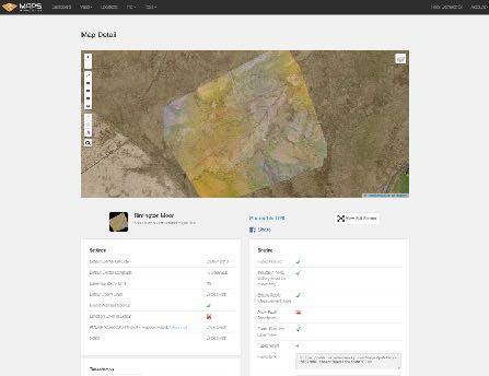
4 Vegetation Mapping A high resolution orhtophotograph of an extensive area of moorland overlain onto standard resolution aerial photo

5 General Aerial Photography A development site in central Lancashire during initial site clearance works

6 360 Panoramas A flat rendition of a 360 degree Panorama (sky photoshopped in!)


7

8 Tree Inspection Close inspection of a tree cavity for bats!


9 Infrared (NDVI) Photography Aerial survey of farmland to check for active plant growth

10 Water Sampling edna perhaps?
11 What types of SUAV are available? Some examples
12 Types of SUAV available SUAVs fall into three main categories Quadcopter (eg Phantom 4) Multi-rotor (eg DJI S1000) Fixed Wing (eg AgEagle Rapid)

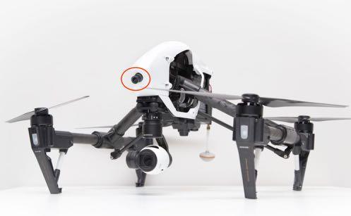
13 Types of SUAV DJI Phantom 4 (Quadcopter)

14 Types of SUAV Multi-rotor - DJI S1000 (Octocopter)

15 Types of SUAV Fixed Wing Drone - AgEagle Rapid
16 SUAVs Most Suited to Ecological Practice Some Specifications For general works, moderately small quadcopter with high resolution camera (eg DJI Phantom or Inspire) For internal work or building inspection, collision sensors essential (eg Phantom 4 or Matrice 100) Need to be compatible with main software providers (eg Pix4d; MapsMadeEasy etc) Moderately priced (?)

17 SUAVs less suited to Large multi-rotors Heavy Ecological Practice Hard to transport Shorter flight time Expensive Designed mainly carry large cameras for professional film production

18 SUAVs less suited to Ecological Practice Small consumer drones (eg Parrot range) Low resolution cameras (if any) mainly used for snapshots and dronies Not usually compatible with mapping software Designed mainly for racing and/or fun!

19 SUAVs less suited to Ecological Practice Fixed wing Agricultural Drones (eg AgEagle) Much less versatile than quadcopter Designed for surveying large open areas of farmland Inability to hover! Limited software compatibility
20 What you need to operate an SUAV (professionally) Training Insurance Permission from the CAA (PfAW; PfCO)
21 What you need to operate an SUAV (professionally) Training Provided by CAA Approved Training Schools Three main elements: Ground school (normally 2-3 days) Flight test Preparation of Operations Manual Guided application for PfCO (Permission for Commercial Operations - replaces PfAW)
22 What you need to operate an SUAV (professionally) Insurance Legal requirement for professional work Needs to cover: Public Liability Damage to or loss of SUAV Damage to or loss of equipment
23 What you need to operate an SUAV (professionally) Permission for Commercial Operations (PfCO) Issued by the Civil Aviation Authority after completion of (approved) training and submission of Operations Manual Required for ALL commercial work, even if not specifically paid for using it! Using an SUAV as an aid or tool still counts as Commercial Work
24 What else do you need? Software Apps Safety Equipment Peripherals
25 What else do you need? Software Aerial Mapping Packages MapsMadeEasy Pix4D SUAV Management and Flight Logging (CAA Requirement) Healthy Drones Drone Log Graphics Software (Photo editing; Photo-stitching; 3D compositing) PTGui Photoshop


26
 SUAV Operation Apps Map Pilot (MapsMadeEasy) Drone Deploy Capture")
27 What else do you need? Apps (for Tablet or Smartphone) SUAV Operation Apps Map Pilot (MapsMadeEasy) Drone Deploy Capture P2V (Pix4D) Litchi Weather Forecast Apps UAV Forecast Weather Online BBC Weather

28

29


30

31 What else do you need? Safety Equipment Fire extinguisher Needs to be capable of dealing with LiPo fire Safety notices & cordon equipment May need to cordon off a work area Hi-vis jacket Useful to know who the pilot and staff are in public places
 NDVI Camera (eg MAPIR) FLIR")
32 What else do you need? Peripherals Dual Cameras (eg FPV plus Hi Res Image Capture) NDVI Camera (eg MAPIR) FLIR Camera (eg Zenmuse XT Drone Thermal Camera) Propellor Guards Guidance System


33

34 My other drone is a Matrice 100 A customisable modular drone by DJI

35 What s in the box? A typical selection of equipment for Ecological Survey
36 Know the Rules and Follow Them! Principle Legislation in the UK - Civil Aviation Authority Air Navigation Order (CAP393) - especially Articles 166 &167 Unmanned Aircraft System Operations in UK Airspace - Guidance (CAP722) Generally 50m from any person, building or vehicle not under your control (30m during take off and landing) 150m from a congested area Maximum height 120m (above local ground level) Maximum distance (line of sight) 500m Permission from the landowner for take off and land (but not to fly over!) Avoid Controlled Airspace

37 Any Questions? General Discussion and Software Demonstration
Year of Autonomy Remotely Piloted Aircraft Systems
 Year of Autonomy 2017 Remotely Piloted Aircraft Systems Who Am I? Bryan Stanislas Membership Director for ARPAS-UK My Background: Marine Media Specialist working in TV, Film, Onshore and Offshore sectors
DRONE / SMALL UNMANNED AIRCRAFT FLYING - ON THE UCL ESTATE
 Mandatory Fire & Safety Instruction DRONE / SMALL UNMANNED AIRCRAFT FLYING - ON THE UCL ESTATE Drones commonly known as Remotely Piloted Aircraft Systems (RPAS) / Unmanned Aerial Vehicles (UAV) / Small
Drone Safety and Commercial Operations IOSH Staffordshire June 2017
 Drone Safety and Commercial Operations IOSH Staffordshire June 2017 Cloudbase Images Ltd Aims of this Presentation To offer an introduction as to the uses of drones across industry To give an indication
Community Directorate. Drone Guidance
 Community Directorate Drone Guidance Community Directorate Harrow Council Civic Centre Station Road Harrow HA1 2XA Tel: 020 8863 5611 Drone Guidance Page 2 Contents 1 Introduction... 4 2 Drones (Commercial
Intro to Small Unmanned Aircraft Systems & Recreational Drones
 Intro to Small Unmanned Aircraft Systems & Recreational Drones Room Assignments Tuesday & Thursday Room 112 Neal Leeper nleeper@cfu.net www.nleeper.com/drone Class Introduction What is your Name? Do
UNMANNED AERIAL VEHICLE SYSTEMS
 UNMANNED AERIAL VEHICLE SYSTEMS UNMANNED AERIAL VEHICLE SYSTEMS INTRODUCTION UAV SYSTEMS APPLICATIONS LEGISLATION SAFETY CONSIDERATIONS HOW TO SELECT A COMPETENT SUPPLIER OF UAV SERVICES Q&A One of Europe's
Drones Use in Forestry: Regulations, Applications, Considerations
 Drones Use in Forestry: Regulations, Applications, Considerations Regulations What is a Drone? Small unmanned aircraft system aka UAV, UAS, suas. Weight is greater than 0.5 lbs. and less than 55 lbs. including
Drones in the Solid Waste Industry
 1 Drones in the Solid Waste Industry Sam Marchant December 4, 2018 Presented By: Sam Marchant, E.I.T. Bachelor of Science in Civil Engineering from Cal Poly, San Luis Obispo Assists in improving efficiency
Drone Guidance. For small unmanned aircraft weighing less than 20kg
 Drone Guidance For small unmanned aircraft weighing less than 20kg Updated 16 th October 2017 Contents Contents... 2 1 Introduction... 3 2 The law... 3 3 The legislation explained... 3 3.1.1 Non-commercial
Unmanned Aerial Vehicle (UAV) Inspection, survey, mapping, modelling & analysis
 Inspection, survey, mapping, modelling & analysis") Unmanned Aerial Vehicle (UAV) Inspection, survey, mapping, modelling & analysis Opus have utilised our own UAV fleet since 2007. They are one of a range of technologies used to enhance our core services.
Unmanned Aerial Vehicle (UAV) Inspection, survey, mapping, modelling & analysis Opus have utilised our own UAV fleet since 2007. They are one of a range of technologies used to enhance our core services.
OCWR DRONE PROGRAM LEA Technical Training Series December 4, 2018
 OCWR DRONE PROGRAM 2018 LEA Technical Training Series December 4, 2018 2 ENTERING THE DANGER ZONE 3 OVERVIEW History of OCWR s Drone Operations Upgrades in Drone Technology FAA Operating Rules FAA Remote
Mapping on a Budget. Using Drones & Digital Data. Jeff Campbell
 Mapping on a Budget Using Drones & Digital Data Jeff Campbell 1 Mapping with Minimal Investment UAS Mapping suited to Incremental Approach Large Up front investment not necessary. Determine if you have
Policy on the Use of Unmanned Aerial Vehicles University of Chichester
 Policy on the Use of Unmanned Aerial Vehicles University of Chichester May 2017 Version 2, SEMT 1 Introduction Unmanned Aerial Vehicles (UAVs) have become far more common in recent years and are beginning
Potential for Using Unmanned Aerial Vehicles (UAV) in an On-Site Inspection
 in an On-Site Inspection") Potential for Using Unmanned Aerial Vehicles (UAV) in an On-Site Inspection Dr James Palmer AWE plc, UK CTBTO Science and Technology Conference 2015 T3.2-06 What is an Unmanned Aerial Vehicle? Different
Potential for Using Unmanned Aerial Vehicles (UAV) in an On-Site Inspection Dr James Palmer AWE plc, UK CTBTO Science and Technology Conference 2015 T3.2-06 What is an Unmanned Aerial Vehicle? Different
Automating Your Monitoring with the Latest suas Technology. Harry White, Forest Ecologist, Colebrook, CT
 Automating Your Monitoring with the Latest suas Technology Harry White, Forest Ecologist, Colebrook, CT Primary Uses: Annual Property Monitoring Easement and Fee Inspections Big-Block Challenges Stewardship
Drones in construction: Worker safety
 Drones in construction: Worker safety Vladimir Murashov, PhD U.S. National Institute for Occupational Safety and Health Washington, D.C. "The findings and conclusions in this presentation have not been
Agricultural Aerial Services
 Agricultural Aerial Services Satellite Imagery Satellite LOW Imagery RESOLUTION IMAGE LOW RESOLUTION IMAGE Satellite Imagery LOW RESOLUTION IMAGE High Resolution Imagery High Resolution SUPERIOR Imagery
ESSENTIAL CONSIDERATIONS FOR DRONE OPERATION.
 GET TING A SAFER B IR DS - E Y E VIEW: ESSENTIAL CONSIDERATIONS FOR DRONE OPERATION. www.cna.com Table of Contents Introduction... 2 Know Who s Up In the Air... 3 Drones by the Numbers... 3 Understand
DRONE-OLOGY - TO INFINTY AND BEYOND! ADSK Solutions. Chad Studer Owner/President
 ADSK Solutions Chad Studer Owner/President ADSK SOLUTIONS SALES - RENTALS CONSULTING - TRAINING - SUPPORT AUTODESK 3D SCANNERS UAV aka DRONES BLUEBEAM Supported Application POINT CLOUDS LIDAR/UAV MOBILE
Unmanned Aerial Systems (UAS) Desk and Derrick Club of Dallas May 3 rd, 2018
 Desk and Derrick Club of Dallas May 3 rd, 2018") Unmanned Aerial Systems (UAS) Desk and Derrick Club of Dallas May 3 rd, 2018 Table of Contents Introduction to UASs Current Market Projections Oil and Gas Adoption FAA & Regulations Oil and Gas Applications
Unmanned Aerial Systems (UAS) Desk and Derrick Club of Dallas May 3 rd, 2018 Table of Contents Introduction to UASs Current Market Projections Oil and Gas Adoption FAA & Regulations Oil and Gas Applications
Using Drones For Aerial Imagery Version v2
 www.skylark-aerialphotography.co.uk Using Drones For Aerial Imagery Version v2 Simon Handley Skylark Aerial Photography Skylark Aerial Photography Skylark Aerial Photography is run by:- Simon Handley My
Unmanned Aircraft Transmission Line Maintenance Technology
 Unmanned Aircraft Transmission Line Maintenance Technology RMEL s Transmission Planning and Operations Conference March 14 th -15 th 2018 Dusty Birge UAV Recon Ft. Collins, CO - Solutions Provider www.uav-recon.com
UAVs - Unmanned Aerial Vehicles in Landscape Practice
 UAVs - Unmanned Aerial Vehicles in Landscape Practice Technical Information Note 3/17 (23rd November 2017) This technical information note aims to help landscape professionals understand the use of unmanned
Overview: Syllabus: Course Outline: Vale UAS Operator Certification
 Course Outline: Vale UAS Operator Certification Overview: This is a four-day course that covers the techniques and best practices required to safely and successfully utilize drones for inspection purposes.
Camera Drones: Market Strategies and Forecasts, Worldwide,
 Camera Drones: Market Strategies and Forecasts, Worldwide, 2016-2022 Camera Drones: Executive Summary Table of Contents The study is designed to give a comprehensive overview of the camera drones equipment
Drones: Are they Risky Business?
 Drones: Are they Risky Business? Andrew Kay- Divisional Vice President Great American Property & Casualty Public Sector Division 10-23-2015 Cool `Footage Headlines Secret Service Arrests Man After Drone
Introduction to Drones
 Introduction to Drones Introduction You can go backwards, you can hover, and you can go straight up or straight down. What is it? It s a bird, it s a plane, no it s a drone! If you are familiar with the
Saving Money with Precision Agriculture
 Saving Money with Precision Agriculture Mark Carter, MBA Delaware County ANR February 22, 2018 Photo from Hay and Forage Growers Today s farm operation requires incredible amounts of cash flow with marginal
DWS CURRICULUM SYNOPSIS
 70 hours over 10 weeks, 7 hours/week DWS CURRICULUM SYNOPSIS DRONE/sUAS PILOT TRAINING PROGRAM What you Receive A 3-ring binder with the modules and information taught in the class One free FAA test Anatomy
Drone Presentation & Demonstration
 Highway 61 North Shore of Lake Superior Drone Presentation & Demonstration National Association of County Engineers Conference April 23 rd 2018 JOE CAMPBELL, P.E., M.S.C.E. Area Engineer/Assistant Division
UAV Or Drone Technology using NDVI Imaging For Crop Monitoring
 UAV Or Drone Technology using NDVI Imaging For Crop Monitoring Naufa N N College of Engineering, Trivandrum(CET) ABSTRACT Drone technology has skyrocketed over the past decade driving costs down and the
HurleyIR Drone Kits HurleyIR is a DJI Authorized Dealer
 The HurleyIR UAS Aerial System is a fully customizable surveillance platform. Cutting edge fail safe technology and intelligent flight modes make flying easy and comfortable for any operator. The included
Drones and Its Applications Manzul Kumar Hazarika, Ph.D.
 Drones and Its Applications Manzul Kumar Hazarika, Ph.D. Director (Project Operations), Geoinformatics Center Asian Institute of Technology (AIT) Thailand manzul@ait.asia This learning material was not
UAV SERVICES. Consult. Trust. Innovate.
 UAV SERVICES Aerial surveys and inspection for the property, rail and infrastructure markets using Unmanned Aerial Vehicles (UAVs) Consult. Trust. Innovate. www.plowmancraven.co.uk Why Walk When You Can
IMPLEMENTING A UAV UNIT FOR YOUR FIRE DEPARTMENT
 IMPLEMENTING A UAV UNIT FOR YOUR FIRE DEPARTMENT ABSTRACT Whether your team is tasked with battling wildfires, search and rescue missions, or dousing a burning building, every piece of data available can
Unmanned Aircraft Systems (UAS) Capabilities and Expertise. Applications of UAS in the Water Resource Industry
 Capabilities and Expertise. Applications of UAS in the Water Resource Industry") Unmanned Aircraft Systems (UAS) Capabilities and Expertise Applications of UAS in the Water Resource Industry Alonso Morales Commercial UAS Pilot Joint Unmanned Systems Management Services March 23rd,
Unmanned Aircraft Systems (UAS) Capabilities and Expertise Applications of UAS in the Water Resource Industry Alonso Morales Commercial UAS Pilot Joint Unmanned Systems Management Services March 23rd,
U g CS for DJI Phantom 2 Vision+
 U g CS for DJI Phantom 2 Vision+ Mobile companion application Copyright 2016, Smart Projects Holdings Ltd Contents Preface... 2 Drone connection and first run... 2 Before you begin... 2 First run... 2
The Sky's the Limit: Using Drones for Environmental Education Seth Engelbourg Naturalist Educator and Program Manager Linda Loring Nature Foundation
 The Sky's the Limit: Using Drones for Environmental Education Seth Engelbourg Naturalist Educator and Program Manager Linda Loring Nature Foundation Uses of Drones Aerial Photography/Cinematography Real
Deploying Low Cost, Small Unmanned Aerial Systems in Humanitarian Mine Action
 Deploying Low Cost, Small Unmanned Aerial Systems in Humanitarian Mine Action J.S. Fardoulis 1, D.A. Smith 1, O.D. Payton 1, T.B. Scott 1, J.E. Freer 2 and J.C.C. Day 1 1 Interface Analysis Centre, School
Drones in Forestry: Regulations, Applications, and Considerations SESAF Conference Darian Yawn Paul Shepard
 Drones in Forestry: Regulations, Applications, and Considerations 2018 SESAF Conference Darian Yawn Paul Shepard About LMSS Forest Technology Solutions Provider Sales, Training, and Support Project Consulting,
Enhancing the Value of Precision Ag Data with Unmanned Aerial Systems (UASs) Mike Buschermohle Precision Ag Specialist UT Extension
 Mike Buschermohle Precision Ag Specialist UT Extension") Enhancing the Value of Precision Ag Data with Unmanned Aerial Systems (UASs) Mike Buschermohle Precision Ag Specialist UT Extension Unmanned Aerial Systems (UASs) Current FAA Regulations UASs UAV, cameras,
Enhancing the Value of Precision Ag Data with Unmanned Aerial Systems (UASs) Mike Buschermohle Precision Ag Specialist UT Extension Unmanned Aerial Systems (UASs) Current FAA Regulations UASs UAV, cameras,
Health and Safety Policy Safe Use of Unmanned Aerial Vehicles (Drones) UHSP/SUUAV/2018
 UHSP/SUUAV/2018") Health and Safety Policy Safe Use of Unmanned Aerial Vehicles (Drones) UHSP/SUUAV/2018 CONTENTS PAGE INTRODUCTION 3 SCOPE OF POLICY 3 DEFINITIONS 3 Drones 3 Commercial Operations 3 Congested Area 4 Visual
Health and Safety Policy Safe Use of Unmanned Aerial Vehicles (Drones) UHSP/SUUAV/2018 CONTENTS PAGE INTRODUCTION 3 SCOPE OF POLICY 3 DEFINITIONS 3 Drones 3 Commercial Operations 3 Congested Area 4 Visual
Mapping with Drones. Key Considerations and Factors to Achieve Desired Accuracy
 JUNE 2017 Mapping with Drones Key Considerations and Factors to Achieve Desired Accuracy 2 Presentation Format 1. Introduction DroneView Technologies 2. Market Focus 2015 through Today 3. Outlook for 2017
CAPABILITY STATEMENT DRONE BUILDING INSPECTIONS DRONE CAMERA ACTION
 CAPABILITY STATEMENT DRONE BUILDING INSPECTIONS DRONE CAMERA ACTION Aerial Photography & Video production for the building, commercial, industrial & film TV industries. CASA Approved Drone Operators (CASA
UAVs 4 STEM. Using recreational drones for learning. March 22, 2016 Presenters: LuAnn Dahlman, NOAA Dan Zalles, SRI
 UAVs 4 STEM Using recreational drones for learning E Federation of Earth Science Information Partners (ESIP) adsf Education Committee March 22, 2016 Presenters: LuAnn Dahlman, NOAA Dan Zalles, SRI Earth
USING RECREATIONAL UAVS (DRONES) FOR STEM ACTIVITIES AND SCIENCE FAIR PROJECTS
 FOR STEM ACTIVITIES AND SCIENCE FAIR PROJECTS") USING RECREATIONAL UAVS (DRONES) FOR STEM ACTIVITIES AND SCIENCE FAIR PROJECTS Education Committee Federation of Earth Science Information Partners Presenter: Shelley Olds, UNAVCO ABOUT ESIP - THE FEDERATION
USING RECREATIONAL UAVS (DRONES) FOR STEM ACTIVITIES AND SCIENCE FAIR PROJECTS Education Committee Federation of Earth Science Information Partners Presenter: Shelley Olds, UNAVCO ABOUT ESIP - THE FEDERATION
DJI PHANTOM 4 PRO. Quick Start Guide. Learn how to use your new DJI Phantom 4 Pro drone with DroneDeploy mapping software.
 DJI PHANTOM 4 PRO Quick Start Guide Learn how to use your new DJI Phantom 4 Pro drone with DroneDeploy mapping software DroneDeploy Introduction In this guide, you ll learn how to use your new DJI Phantom
UNMANNED AERIAL VEHICLES POLICY
 UNMANNED AERIAL VEHICLES POLICY Effective from 01 December 2015 Purpose The purpose of this policy is to: Define Council s policy towards the use of Unmanned Aerial Vehicles (UAVs) on Council owned land
USING UNMANNED AERIAL VEHICLES USING UNMANNED AERIAL VEHICLES
 LAND GEOSPATIAL SERVICES SERVICES LAND SURVEY SURVEY AND AND GEOSPATIAL USING UNMANNED AERIAL VEHICLES USING UNMANNED AERIAL VEHICLES AE R I AL IINSPECTION N S P E CT I O N AND AN D SURVEYING S U R V E
Such a category, which is sometimes referred to as a "micro" or "open" category, presents several benefits, including:
 August 28, 2015 Via email: carrac@tc.gc.ca Canadian Aviation Regulations Advisory Council Transport Canada 330 Sparks Street Ottawa, ON K1A 0N5 Re: Notice of Proposed Amendment #2015-012 (Unmanned Air
MONTANA UNIVERSITY SYSTEM RESEARCH INITIATIVE
 MONTANA UNIVERSITY SYSTEM RESEARCH INITIATIVE Autonomous Aerial Systems for Wildfire Management in Montana Fifth Quarterly Report May 30, 2017 Submitted by: Carl Seielstad, Project Lead and Principle Investigator
2016 AASHTO Subcommittee on TSM&O
 2016 AASHTO Subcommittee on TSM&O New Technology Trends for Transportation Unmanned Aerial Systems (UAS) for Transportation Purposes Steven J. Cook, P.E. Engineer of Operations & Maintenance Michigan Department
16bn. 42bn 628,000 76,000. Poised for take-off. increase in UK gross domestic product (GDP) in net cost savings to the UK economy
 in net cost savings to the UK economy") Poised for take-off Drones are becoming an increasingly familiar aspect of life and work in the UK today, playing a growing role in areas ranging from emergency services to construction to oil and gas.
Poised for take-off Drones are becoming an increasingly familiar aspect of life and work in the UK today, playing a growing role in areas ranging from emergency services to construction to oil and gas.
Applications for Unmanned Aerial Vehicles (UAVs) in Electric Utility Construction Cross Border Meeting Cartagena, Columbia March 17, 2016
 in Electric Utility Construction Cross Border Meeting Cartagena, Columbia March 17, 2016") Applications for Unmanned Aerial Vehicles (UAVs) in Electric Utility Construction Cross Border Meeting Cartagena, Columbia March 17, 2016 UAV Benefits to the Industry Up-close inspections of energized
Applications for Unmanned Aerial Vehicles (UAVs) in Electric Utility Construction Cross Border Meeting Cartagena, Columbia March 17, 2016 UAV Benefits to the Industry Up-close inspections of energized
P ublic Safety Ca t a l o g Fa l l
 P ublic Safety Ca t a l o g Fa l l 2 0 1 6 Co n tac t u s at: Phone: 877-979-4552 Fax: 877-979-4552 Company Address: 50 W. 14th Street Holland, MI 49423 Mailing Address: P.O. Box 8233 Holland, MI 49422
Taking Off With Drones. December 4, :45 4:45 Workshop Block II Brian D Simmons, P.E., FAA 107 Principal Engineer Bolton & Menk Inc.
 Taking Off With Drones December 4, 2017 3:45 4:45 Workshop Block II Brian D Simmons, P.E., FAA 107 Principal Engineer Bolton & Menk Inc. Taking Off With Drones Regulations UAV/Drone Implementation & your
Drones and Their Role in Agriculture. Mike Buschermohle Precision Ag Specialist UT Extension
 Drones and Their Role in Agriculture Mike Buschermohle Precision Ag Specialist UT Extension Current FAA Regulatory Environment Public UASs can fly under a Certificate of Authorization (COA). Government
AERIAL INSPECTIONS USING UNMANNED AERIAL VEHICLES
 AERIAL INSPECTIONS USING UNMANNED AERIAL VEHICLES MICHAEL A. PEREZ, WESLEY C. ZECH, PH.D., WESLEY N. DONALD, PH.D. MRN/SWANA MID-ATLANTIC A N N UA L C ONFERENCE ELLICOTT CITY, MD JUNE 22, 2016 Research
CURRICULUM SAMPLE. The Anatomy of a Drone DAY STEM CONNECTIONS DURATION MATERIALS
 32 The Anatomy of a Drone SCHEDULE STEM CONNECTIONS Technology: Empowered Learning DURATION 60 Minute Lesson MATERIALS Recap (5 min) All 5 drones All 5 radio controllers, charged All batteries, charged
Components of a Quadcopter SYST 460
 Components of a Quadcopter SYST 460 https://www.dronezon.com/learn-about-drones-quadcopters/drone-components-parts-overview-with-tips/ A. Standard Prop While some drones like the DJI Phantom look more
Drone regulation FAQ
 Drone regulation FAQ Does someone need to have a license to fly a drone in Cyprus?... 2 Is someone allowed to bring his/her drone to Cyprus when on holiday? Does he have to declare it in Customs?... 3
2017 NMARC/ASMCRA. Take to the Skies: Using Drone Technology as a Tool
 2017 NMARC/ASMCRA Take to the Skies: Using Drone Technology as a Tool Unmanned Aerial Systems (UAS) for Transportation Purposes Hilary Owen, P.E. Systems Operations Engineer Michigan Department of Transportation
Drones What Could Possibly Go Wrong?
 Drones What Could Possibly Go Wrong? A Discussion of the Legal and Liability Aspects of Operating Drones by Commercial Entities L O C K T O N C O M P A N I E S What is a DRONE Fixed Wing: Longer Range
Figure 1 Hybrid wing high-altitude long-endurance UAV
 GSMA Internet of Things Case Study Ground-to-air LTE communication services for industrial drone applications Executive Summary With the increasing use of drones for industrial applications, China Unicom
UAV's ability to make mapping and aerial photography increasing - cost cheaper, more accurate, RTK technology and improved payload.
 GEOSMART ASIA 2017 OVERVIEW UAV's ability to make mapping and aerial photography increasing - cost cheaper, more accurate, RTK technology and improved payload. 90 80 70 60 50 40 30 20 10 0 UAV MAPPING
SAFE DRONES FOR INACCESSIBLE PLACES
 SAFE DRONES FOR INACCESSIBLE PLACES Johan Mlouka The Impact of New Technology on HSE : How Are Drones Currently Having an Impact on Improving HSE Procedure for Industrial Assets Owner, Opportunities and
Unmanned Aerial Systems
 DHS SCIENCE AND TECHNOLOGY Unmanned Aerial Systems Considerations for First Responder Organizations February 28, 2017 Stephen Hancock Director of Special Projects First Responders Group Science and Technology
Switching to Auto Follow...4. Presentation of the flight Magic Dronies Locking the screen...10 Exiting auto follow...
 USER GUIDE TABLE OF CONTENTS Follow...1 Me GPS & Visual tracking Auto...1 Follow...2 Switching to Auto Follow mode...4 Presentation of the flight screen...5 Meaning of the colours of the auto follow frame...6
Unmanned Aerial Vehicles. What does the future of the aviation industry look like? Does it contain the use of
 Goss 1 Hunter Goss Ms. Dasher British Literature and Composition 7 December 2016 Unmanned Aerial Vehicles What does the future of the aviation industry look like? Does it contain the use of Unmanned Aerial
Utilization of Unmanned System Technology in Transportation Engineering
 Utilization of Unmanned System Technology in Transportation Engineering Dr. Michael R. Williamson Assistant Professor Indiana State University Sam Morgan Instructor Indiana State University Overview Parking
Presentation and Contents copyright QuestUAV Ltd 2013
 Where is the UAV industry taking us in remote sensing capability and what lies ahead? An industry leader s point of view. Nigel King FBIPP UAVSA CEO QuestUAV Fixed Wing Orientated Talk UAV = RPA About
RPAS/UAV: Challenges and opportunities from an insurance perspective
 Allianz Global Corporate & Specialty RPAS/UAV: Challenges and opportunities from an insurance perspective Thomas Cahlik, Sept 30, 2015 1 Table of contents 1 Introduction 2 3 4 5 Opportunities Regulatory
Drone Surveying: The Complete Story
 Drone Surveying: The Complete Story NYSAPLS Friday Webinar Series December 1, 2017 Aerotas enables surveyors to map by drone More than: 60 clients, 600 drone surveys, 450 hours of field testing & training,
Drone Usage in the Broadband (Air)Space
Space") Drone Usage in the Broadband (Air)Space Daryl Atley Zakov Attorney Bennet & Bennet, PLLC Four Objectives of Session n UAV/Drones 101: Understanding the Basics and Terminology n The Aeronautical Technology
Drone Usage in the Broadband (Air)Space Daryl Atley Zakov Attorney Bennet & Bennet, PLLC Four Objectives of Session n UAV/Drones 101: Understanding the Basics and Terminology n The Aeronautical Technology
Responses to Questions Asked by BIS Ahead of Challenger Business Programme UAV Workshop, 23/11/15
 Responses to Questions Asked by BIS Ahead of Challenger Business Programme UAV Workshop, 23/11/15 Authors: Dr Darren Ansell, Dr Andrew Heaton, UCLan. i Introduction This document is the University of Central
DRONES A Brief History and Design Overview. Tomorrow Lab June 2014
 DRONES A Brief History and Design Overview Tomorrow Lab June 2014 INTRODUCTION The intent of this document is to give a brief history and overview of drone technology from a design and engineering perspective,
Order on flights with drones outside built-up areas 1
 Order no. 788 of 14 June 2017 Order on flights with drones outside built-up areas 1 In pursuance of 126 b (3) and (4), 126 c (3-5), 126 d (4) and (5), 126 f (2), 126 h and 149 (10) of the Danish Air Navigation
Campus Unmanned Aircraft System (Drone) Policy
 Policy") University of California, Berkeley Policy Issued: May 1, 2018 Effective Date: May 15, 2018 Supersedes: None, New Policy Next Review Date: May 15, 2023 Campus Unmanned Aircraft System (Drone) Policy Responsible
University of California, Berkeley Policy Issued: May 1, 2018 Effective Date: May 15, 2018 Supersedes: None, New Policy Next Review Date: May 15, 2023 Campus Unmanned Aircraft System (Drone) Policy Responsible
Billy Walker Co-President of CLL
 Is there a drone in your future? What drone should I buy Different types of drones What can one do with a drone FAA Drone Regulations Tips on shooting video with drone Editing your drone video Billy Walker
GRFD Standard Operating Guideline
 GRFD Standard Operating Guideline Unmanned Aerial Vehicle (UAV) Reviewed Date: Reviewed By: Fire Chief Lehman SOG #: 201 50 Date: 2017 05 19 Rev. Date: Fire Chief: John Lehman PURPOSE: To enhance firefighter
U g CS for DJI Phantom 2 Vision+, Phantom 3 and Inspire 1 Mobile companion application
 U g CS for DJI Phantom 2 Vision+, Phantom 3 and Inspire 1 Mobile companion application Copyright 2015, Smart Projects Holdings Ltd Contents Preface... 2 Drone connection and first run... 2 Before you begin...
Michigan Department of Transportation
 Evaluating the Use of Unmanned Aerial Systems (UAS) for Transportation Purposes Michigan Department of Transportation Steven J. Cook, P.E. Engineer of Operations & Maintenance UAS Benefits for Transportation
10/24/2018 DRONING ON FOLLOWING THE RULES AND FUTURE FUN. RULES AND PENALTIES Canadian Aviation Regulations s
 DRONING ON FOLLOWING THE RULES AND FUTURE FUN Heather C. Devine and Michelle L. Staples Isaacs & Company Toronto, Ontario RULES AND PENALTIES Canadian Aviation Regulations s. 602.41 No person shall operate
P310 VTOL UAV CHC P310 VTOL UAV. Zhen Yann Zhen Yann - UAV Product Manager UAV Product Manager Shanghai, 15 February,2017 Shanghai - Feburary 15, 2017
 P310 VTOL UAV CHC P310 VTOL UAV Zhen Yann Zhen Yann - UAV Product Manager UAV Product Manager Shanghai, 15 February,2017 Shanghai - Feburary 15, 2017 1 CHC Profile 2 CHC VTOL UAV Introduction 3 4 CHC VTOL
U g CS for DJI. Mobile companion application. Copyright 2016, Smart Projects Holdings Ltd
 U g CS for DJI Mobile companion application Copyright 2016, Smart Projects Holdings Ltd Contents Preface... 3 Drone connection and first run... 3 Before you begin... 3 First run... 3 Connecting smartphone
STORMBEE Quick Reference Handbook
 STORMBEE Quick Reference Handbook Think 3D 30/09/2018 PAGE INTENTIONALLY LEFT BLANK 2/1 Version Control Author Date Version Comments/ Adaptations Jon Verbeke 26/04/2018 1.0 First draft Jon Verbeke 30/09/2018
Quadcopters And Drones: A Beginner's Guide To Successfully Flying And Choosing The Right Drone By Mark D Smith READ ONLINE
 Quadcopters And Drones: A Beginner's Guide To Successfully Flying And Choosing The Right Drone By Mark D Smith READ ONLINE You would think finding the best drones for kids and beginners The best selling
Small-scale Mapping with Consumer Drones in Nepal
 Drones in Humanitarian Action Case Study No.3: Natural Disasters / Acute Emergency / Mapping Small-scale Mapping with Consumer Drones in Nepal The aims of the project were to provide drone training to
Eyes. Growth IN THE SKY AERYON LABS DRONES PUT MIDDLE MARKET M&A DEAL INSURANCE GAINS POPULARITY
 Growth MIDDLE MARKET // MAY/JUNE 2016 M&A DEAL INSURANCE GAINS POPULARITY A QUALIFIED OPINION: DAVID MELCHER, PRESIDENT & CEO, AEROSPACE INDUSTRIES ASSOCIATION AERYON LABS DRONES PUT Eyes IN THE SKY The
Drones to the Rescue: Utilizing Drones for the Preservation and Restoration of Life and Property. Randall Ishikawa
 Drones to the Rescue: Utilizing Drones for the Preservation and Restoration of Life and Property Randall Ishikawa Agenda 1 2 3 4 5 6 Current Conditions UAS Adoption Aerial Imagery Capabilities Use Cases
DroneDeploy. DroneDeploy's 2017 Drone Buyer s Guide. The Ultimate Guide to Choosing a Mapping Drone for Your Business
 DroneDeploy DroneDeploy's 2017 Drone Buyer s Guide The Ultimate Guide to Choosing a Mapping Drone for Your Business Table of Contents 01 Preparing for Takeoff Introduction... 3 02 Getting Started What
Drone Transponders Market Shares, Strategies, and Forecasts,Worldwide, 2016 to 2022
 Report Information More information from: https://www.wiseguyreports.com/reports/1098687-drone-transponders-market-shares-strategies-andforecasts-worldwide-2016-to-2022 Drone Transponders Market Shares,
CrystalSky Release Notes
 Date: 2018.05.25 V02.06.06.00 DJI GO 3 App: V 3.1.38 DJI GO 4 App: V 4.2.16 DJI Pilot Beta: V 0.5.1 Updated DJI GO 4 app to version 4.2.16. Updated DJI GO 3 app to version 3.1.38. Optimized temperature
SOLUTIONS PROFILE 17 PATHWAYS 2 SOLUTIONS, INC. AERIAL IMAGERY SOLUTIONS ARE HERE NOW...
 SOLUTIONS PROFILE 17 Marketing Advertising Real Estate Mapping and Surveying Aerial Imagery Security 3D Modeling Mining and Agriculture Utilities Power Grid Transportation PATHWAYS 2 SOLUTIONS, INC. AERIAL
Drone technology has skyrocketed over the past decade driving costs down and the
 I. ABSTRACT Drone technology has skyrocketed over the past decade driving costs down and the number of potential applications up, one being agricultural crop monitoring. Normalized Difference Vegetation
Lesson Learned Current Drone Usage
 Lesson Learned Current Drone Usage Primary Interest Groups Transmission Owners (TOs) Transmission Operators (TOPs) Generation Owners (GOs) Generation Operators (GOPs) Introduction Some entities have begun
Drone Basics 101 Technology, Regulations and Project Examples. Tom Gehrdes & Alton Whittle
 Drone Basics 101 Technology, Regulations and Project Examples Tom Gehrdes & Alton Whittle What are UAVs? Unmanned Aerial Vehicles (UAVs) are remotely operated aircraft that fly without the possibility
University of Derby Department of Electronics, Computing and Mathematics
 University of Derby Department of Electronics, Computing and Mathematics A project completed as part of the requirements for BSc (Hons) Computer Forensic Investigation entitled A Forensic Analysis of the
Drones - Now and Future. Bob Barton MLMUG February 10, 2018
 Drones - Now and Future Bob Barton MLMUG February 10, 2018 1 Overview What are drones? Land, Sea and Air Quad copters how they work Cameras and mounts Image processing Manufacturers and Markets Rules Advanced
Drones are Heating Up A Survey of Common Applications for Drone-based Thermal Imaging
 Drones are Heating Up A Survey of Common Applications for Drone-based Thermal Imaging Ed Kochanek, Director of Sales, Key Account Manager & David Lee FLIR Systems, Inc. 22 Overlook Drive Woolwich, NJ 08085