Pattullo Bridge Replacement Project. Business Case
|
|
|
- Tamsin Powell
- 6 years ago
- Views:
Transcription

1 Business Case January 2018
2 Business Case Page i TABLE OF CONTENTS EXECUTIVE SUMMARY... 1 Investment Need... 1 The Project... 1 Scope of the Project... 2 Benefits for the Province and Region... 2 Procurement Assessment and Project Delivery... 3 Funding PURPOSE AND APPROACH Purpose Approach... 5 PART A RATIONALE FOR THE PROJECT STRATEGIC CONTEXT Metro Vancouver Pattullo Corridor and Connections Province of British Columbia Pattullo Bridge Replacement Project EXISTING CHALLENGES Physical Condition Access and Travel Time Challenges Community Livability Challenges Capital Investment Need ASSESSMENT OF OPTIONS Options for Bridge Replacement Strategic Options Analysis Connection Options Analyzed MAE Framework and Results Recommendation Capital Cost Estimate Benefit Cost Sensitivity Analysis Achievement of Project Goals PART B DELIVERY OF THE PROJECT... 31
3 Business Case Page ii 5 PHYSICAL ASSET SCOPE Overview Operation, Maintenance, and Rehabilition Scope PROJECT STATUS Consultation with Stakeholders and the Public To date Technical Planning Environmental Review and Permitting Municipal Liaison Aboriginal Groups Community Benefits Policy Property Utilities Railways PART C PROCUREMENT DELIVERY MODEL OPTIONS ANALYSIS APPROACH Procurement Options Identification Procurement Options Analysis Overview PROCUREMENT OPTIONS ANALYSIS DB VERSUS DBF Multiple Criteria Analysis Risk Analysis Financial Modelling Value for Money Calculation Market Sounding RECOMMENDED PROCUREMENT OPTION PART D PROCUREMENT PLAN AND FUNDING PROCUREMENT IMPLEMENTATION PLAN Recommended Procurement Process Project Schedule Project Governance Project Stakeholder and Public Communications and Consultation Environmental Assessment Consultation Performance Measurement FUNDING... 63
4 Business Case Page iii 11.1 Sources of Funds Project Cash flows PART E RECOMMENDATION... 65
5 Business Case Page iv LIST OF TABLES Table 1: Summary MAE and BCR Table (NPV 2017)... 3 Table 2: Project Timeline... 4 Table 3: Provincial Debt... 4 Table 4: Project Drivers Table 5: MAE Analysis Summary Table 6: Financial Account Summary Table 7: Capital Cost Estimate Table 8: Benefit Cost Sensitivity Analysis Table 9: Achievement of Project Goals Table 10: Qualitative Procurement Options Assessment Criteria Table 11: Qualitative Assessment Scoring Framework Table 12: Qualitative Assessment Summary Table 13: Summary Risk Allocation Matrix Table 14: Summary of Risk Values Table 15: Project Financial Assumptions Used in the Shadow Bid Model Table 16: Total Project Cost Table 17: Value for Money Table 18: Discount Rates Used in VFM Sensitivity Analysis Table 19: Interest Rates Used in VFM Sensitivity Analysis Table 20: Performance Measurements Table 21: Provincial Debt Table 22: Project Cash Flow During Construction... 64
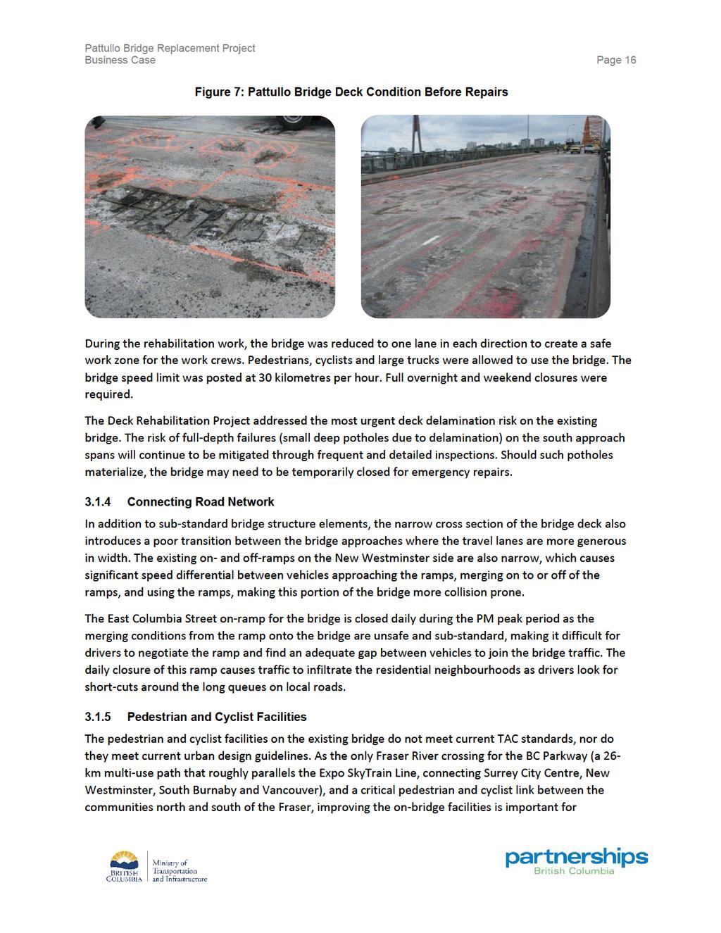
6 Business Case Page v LIST OF FIGURES Figure 1 - Existing Pattullo Bridge Corridor... 8 Figure 2: Downtown Surrey... 8 Figure 3: New Westminster Boardwalk... 9 Figure 4: Proportion of Heavy Truck Trips by Freight Market Sector in Metro Vancouver Figure 5: Location of the New Bridge Figure 6: Sub-optimal Design Standards on the Existing Pattullo Bridge Figure 7: Pattullo Bridge Deck Condition Before Repairs Figure 8 - Recommended Option (Option 3) Map* Figure 9: Overview of VFM Approach Figure 10: Value for Money Graph Figure 11: Project Schedule Figure 12: Project Governance Structure Figure 13: Public Input Opportunities... 58
7 Business Case Page 1 EXECUTIVE SUMMARY The existing Pattullo Bridge, which spans the Fraser River between the City of Surrey and the City of New Westminster, was built in 1937 and is near the end of its useful life. It is vulnerable to seismic events and high winds, marine collisions and river scour. The bridge does not meet current roadway design guidelines, including lane widths and road curvatures. This Business Case recommends the implementation of the Pattullo Bridge Replacement Project (the Project), which includes a new, four-lane bridge that meets current seismic and road design standards, and provides a safe and reliable crossing for vehicles, pedestrians and cyclists, network connections in Surrey and New Westminster and the removal of the existing bridge. The new bridge with key road connections in New Westminster and Surrey will be in place in The new four-lane bridge will be designed in a manner to not preclude a potential future expansion to six lanes. Further approvals and technical work will be required to determine the broader road network improvements needed to support any potential future expansion of the bridge. The Project represents a significant investment in multi-modal transportation mobility improvements and supports provincial and regional strategies, environmental objectives, and the economic development of transportation services in the region. This Business Case establishes the need and rationale for investing in the Project, along with the context that drives the urgent need to replace this important link in the regional transportation network. This Business Case recommends proceeding with the Project at an estimated total cost of $1.377 billion. INVESTMENT NEED The Pattullo Bridge is an important element of the transportation network in Metro Vancouver. The bridge provides a critical transportation link for local and regional transportation and is an important component of the Asia-Pacific Gateway goods movement network, serving local, regional and national needs. The challenges associated with the aging existing bridge include a delaminating deck; river scour around the foundations; piers not designed to withstand significant collisions with marine vessels; seismic and wind load thresholds that do not meet current standards for new structures; horizontal curves, travel lanes and sidewalk widths that do not meet current standards for new structures; and the absence of safety features such as median barriers and shoulders. A regular maintenance program has extended its lifespan, but escalating efforts to prolong its use are no longer cost effective. An assessment of maintenance needs has revealed that upgrading the bridge to meet modern safety standards would be extremely challenging, both technically and financially. THE PROJECT Efforts to identify a solution for the aging Pattullo Bridge have been underway since Between 2012 and 2014, a comprehensive joint technical Strategic Review Process (the Strategic Review) was led by TransLink to develop and evaluate options to rehabilitate or replace the Pattullo Bridge. More than
8 Business Case Page 2 25 alternatives were explored through technical and financial analysis and extensive public and stakeholder consultation. As a result of this work, replacement of the bridge was determined to be the most viable solution. Three general goals guide the Project: Provide a structurally sound bridge crossing to maintain a critical local and regional connection; Improve safety for all users with modern lane widths, road curvature, centre median and separated pedestrian/cyclist facilities; and Improve connectivity, reliability and modal choice while supporting environmental objectives. In June 2014, the Mayors Council on Regional Transportation (Mayors Council) confirmed the region s preferred solution to replace the existing structure in its Vision for Regional Transportation for Metro Vancouver. The Mayors Council determined that the replacement bridge should be a new, four-lane bridge, designed in a manner to not preclude potential future expansion to six lanes. On January 25, 2018 the Mayors Council unanimously reaffirmed its support for the Project. SCOPE OF THE PROJECT The Pattullo Bridge is planned to be replaced with a new four-lane bridge. The scope of the Project is as follows: A safer crossing with modern lane widths to accommodate standard passenger and commercial vehicles sizes, separated by a centre median to ensure improved safety for all bridge users; Pedestrian and cyclist facilities, separated from traffic on both sides of the bridge; Network connections to New Westminster and Surrey; and Removal of the existing aging structure. The Project will be designed to meet modern seismic, structural, and roadway geometry standards. It will improve safety for drivers, cyclists and pedestrians. BENEFITS FOR THE PROVINCE AND REGION The Project provides a number of benefits to the region and the local communities. With a benefit-cost ratio (BCR) of 2.01, this Project fulfills the requirement to provide a new, four-lane bridge, which will meet modern seismic and road geometry standards for a safer and more reliable crossing. The improved cycling and pedestrian facilities will make active travel on and around the bridge safer.
9
10
11 Business Case Page 5 1 PURPOSE AND APPROACH 1.1 PURPOSE This Business Case establishes the need to invest in replacing the Pattullo Bridge and improving the Pattullo Bridge corridor, and describes how the Project will contribute to provincial and regional objectives and strategies to improve transportation infrastructure in Metro Vancouver. The main purpose of this Business Case is to: Demonstrate the need and provide background information with respect to the Project; Describe in detail the planning process and recommended project scope to meet the need; Describe in detail the procurement analysis conducted for the Project; and Recommend a procurement approach and implementation strategy. This Business Case is intended to provide information and analysis to inform decisions on the Project. 1.2 APPROACH The document consists of the following five main sections: Part A - Rationale for the Project: Describes the need for the new bridge and improved community connections based on current and forecasted traffic demands, community improvements, and regional plans. This includes a description of the strategic context and an overview of the Project. Part B - Delivery of the Project: Describes the physical project elements through the development of a reference concept, and estimates the costs that will be incurred to implement these recommendations. Part C - Procurement Delivery Model Options Analysis: Analyzes and compares the procurement methods considered. This section uses qualitative and quantitative analysis based on the results of financial modeling, risk quantification, risk analysis, and a Multiple Criteria Analysis (MCA) of the procurement options, to ensure the Project goals and procurement objectives are satisfied. Part D - Procurement Plan and Funding: Identifies funding sources and recommends the preferred procurement process. Part D also includes the procurement plan, schedule and budget. Part E - Recommendation: Presents the specific recommendation to proceed with this Project.
12 Business Case Page 6 PART A RATIONALE FOR THE PROJECT This section of the Business Case describes the need for the Project. The discussion highlights key aspects of the Project, and how planned improvements will address the challenges.
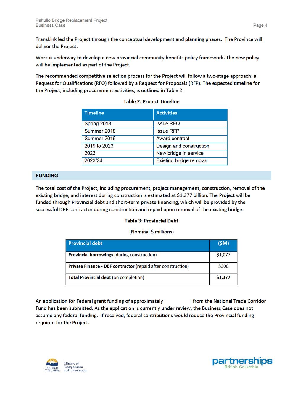
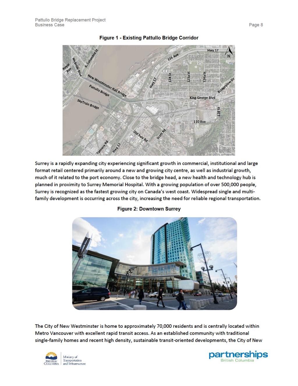
13 Business Case Page 7 2 STRATEGIC CONTEXT 2.1 METRO VANCOUVER Metro Vancouver is one of Canada s most diverse and livable regions, with vibrant communities and an internationally recognized high quality of life. It is the third-largest urban area in Canada, with 2.3 million residents and 1.3 million jobs across a diverse economy. Metro Vancouver is expected to welcome one million additional residents over the next 30 years, adding 500,000 jobs and three million more passenger trips every day. The location of Metro Vancouver makes it an ideal centre for international trade, connecting British Columbia and Canada with the United States, Asia and the rest of the world. The Metro Vancouver region plays a critical role as one of Canada s Pacific Gateways, connecting international port terminals in Roberts Bank and Burrard Inlet with the country s national road and rail transportation corridors, and providing critical transportation networks that connect Canada s economy to Asia-Pacific trading partners. Gateway-related goods movement is forecast to grow and drive the regional, provincial and national economies, increasing the need for a reliable and efficient regional transportation network. The Pattullo corridor is a key component of this transportation network. Transportation planning in the Metro Vancouver region is guided by a number of overarching strategies, including Metro Vancouver s Metro Vancouver 2040 (Regional Growth Strategy, RGS) and TransLink s Regional Transportation Strategy (RTS) and Moving the Economy: A Regional Goods Movement Strategy for Metro Vancouver (RGMS). These regional strategies seek to balance social, economic, and environmental objectives and address challenges common to urban regions. Metro Vancouver s role as one of Canada s Pacific Gateways amplifies the challenges of balancing livability with providing a transportation system that not only supports local residents and businesses, but also supports a growing volume of trips passing through the region to markets beyond our borders. 2.2 PATTULLO CORRIDOR AND CONNECTIONS The central location of the bridge makes it a vital link in the regional transportation network for people, goods and services. Before tolls were removed from the Port Mann and Golden Ears Bridges, the bridge carried, on average, 77,000 vehicles per day, approximately seven per cent of which were trucks. Since the tolls were removed, traffic counts are showing an approximate 12 percent reduction in average daily traffic (approximately 68,000 vehicles per day) in the month of September 2017 over September The Pattullo corridor connects King George Boulevard, Scott Road and, indirectly, Highway 17 in Surrey with McBride Boulevard, Columbia Street and Royal Avenue in New Westminster Linking Metro Vancouver Communities The Pattullo corridor is critical for local travel between two city centres on either side of the Fraser River: New Westminster and Surrey.
14

15 Business Case Page 9 Westminster s key considerations regarding the new bridge are that it supports existing economic activity and facilitates redevelopment while preserving community livability goals. Significant commercial and industrial development happening on both sides of the city (Queensborough and Brunette areas) are creating more demand for better transportation links through and in and out of New Westminster. Ensuring good access to the Royal Columbian Hospital, close to the Pattullo Bridge and Highway 1, is also a priority. Figure 3: New Westminster Boardwalk Service to Major Gateways The Pattullo corridor connects provincial and regional routes with municipalities north and south of the Fraser River. The corridor also supports Metro Vancouver s role as one of Canada s Asia Pacific Gateways by linking key Regional Activity Centres with Gateway/International Activity Centres. It provides a direct connection between industrial lands in New Westminster and Surrey. The existing Pattullo Bridge is identified as a transportation network priority in a number of strategic plans, including the Gateway Transportation Collaboration Forum s Greater Vancouver Gateway 2030 report. In combination with Highway 17, it also provides important goods movement and trade linkages between Roberts Bank Terminal, the Fraser River Trade Area and the adjacent communities. Of the one million heavy trucks that cross the bridge each year, 45 to 50 per cent of them are transporting goods for the Asia-Pacific Gateway. Figure 4 highlights the relative volume and proportion of heavy trucks on major corridors in Metro Vancouver.

16 Business Case Page 10 Figure 4: Proportion of Heavy Truck Trips by Freight Market Sector in Metro Vancouver 2.3 PROVINCE OF BRITISH COLUMBIA The Province has identified a number of key strategic initiatives to make life more affordable, improve services, and create good jobs and a sustainable economy for residents of BC. The Project is aligned with these initiatives. Transportation investments generate immediate employment, underpin ongoing job creation and promote economic development by providing people with better access jobs and enabling goods and services to be delivered more efficiently. In addition, the transportation sector plays an important role in B.C. s economy. A 2016 study by the Conference Board of Canada identified transportation and warehousing as the most concentrated industrial cluster in the Metro Vancouver area relative to the rest of Canada. According to the Economic Impact Analysis produced for the Vancouver Gateway Council in 2017, the sector is growing at rates exceeding the national average and has created more than 30,000 jobs in Metro Vancouver in the last 25 years.
17
18

19 Business Case Page 13 The Project will be located just north and upstream of the existing bridge and continue to link the communities of New Westminster and Surrey (see Figure 5). This will allow the new bridge to optimize the use of existing road infrastructure and established travel patterns, and improve connections to Highway 17. Constructing the bridge in parallel to the existing bridge will also allow the continuous operation of the old bridge until the new one is open. Figure 5: Location of the New Bridge Key Project Milestones The Project is currently undergoing a review by the BC Environmental Assessment Office and the Vancouver Fraser Port Authority through a harmonized provincial Environmental Assessment (EA) and Port Project Environmental Review (PER). This review is anticipated to be completed in late The new four-lane bridge and road connections are included in the scope of the EA to ensure that the impacts of all planned project elements are studied.
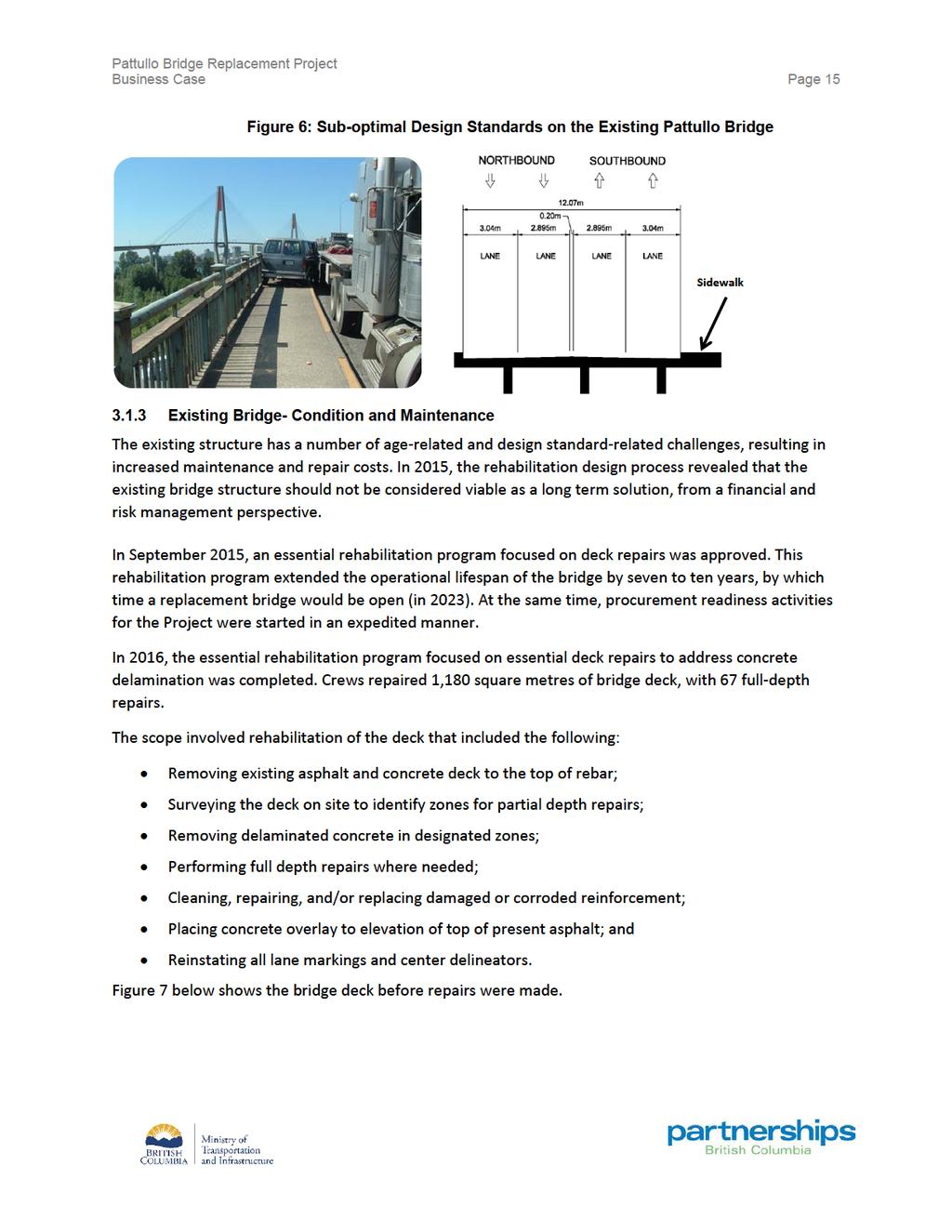
20 Business Case Page 14 3 EXISTING CHALLENGES 3.1 PHYSICAL CONDITION Existing Bridge Structural The Pattullo Bridge was designed based on the 1929 Canadian Engineering Standards Association design code. While the bridge is inspected regularly to ensure it remains functional, it does not meet the current design standards for a new bridge built today: The absence of safety features such as median barriers and shoulders; Horizontal curves, travel lanes and sidewalk widths that do not meet current standards for new structures; Delaminating deck; River scour around the foundations; Piers not designed to withstand collisions with marine vessels; and Seismic and wind load thresholds that do not meet current standards for new structures. A regular maintenance regime has extended its lifespan, but escalating efforts to prolong its use are no longer cost effective. An assessment of maintenance needs has revealed that upgrading the bridge to meet modern standards would be extremely challenging, both technically and financially Existing Bridge - Lane Widths The current bridge was originally constructed as a two-lane crossing and is now configured for four lanes. Each lane is 2.9 to 3.0 metres in width, significantly narrower than the current Transportation Association of Canada (TAC) standard of 3.5 to 3.7 metre lane widths for straight sections of road, with additional width required on curves. Commercial vehicles often straddle two lanes in order to safely use the bridge, which reduces bridge capacity, impeding the flow of other vehicles, and increases driver workload when crossing the bridge. The current bridge deck is not wide enough to accommodate a centre median. For safety reasons, current practice has the centre lanes closed at nighttime when the risk of a collision is greatest. While this has reduced the number of nighttime accidents on the bridge, such closures are not a viable longterm solution. As shown in Figure 6, narrow lane widths combined with heavy traffic volumes frequently lead to extended bridge closures during incidents.
21
22
23 Business Case Page 17 encouraging walking and cycling in the region. A 2002 study by Urban Systems on the bridge bicycle safety and access identified the following issues: Lack of barriers between the roadway and sidewalk; Narrow width of sidewalk to accommodate multi-modal use; Limited sight distance; and Intrusions/obstructions on bridge sidewalk and its approaches. Off the bridge deck there are also a number of issues with pedestrian and cyclist safety. In New Westminster, the primary areas of concern are related to how the bridge head and connecting roads divide the community without adequate facilities to walk and cycle between the Victoria Hill neighbourhood and downtown New Westminster. The current conditions make walking and cycling undesirable for all users. In Surrey, the primary areas of concern are related to indirect connections between the BC Parkway and the Scott Road SkyTrain Station, and between the Bridgeview neighbourhood (both residential and industrial) and Scott Road SkyTrain Station. 3.2 ACCESS AND TRAVEL TIME CHALLENGES Travel Time Challenges The narrow lanes and the sub-standard geometry on the existing bridge reduce the traffic capacity on the bridge due to slower traveling speeds and lane straddling. Traffic counts have shown that the maximum throughput of the existing bridge, which is the maximum amount of traffic able to cross the bridge in each direction, is approximately 3100 to 3200 vehicles per hour (vph). A modern four-lane bridge with standard lane widths and design should have a throughput in the range 3500 to 3600 vph. To mitigate impacts of the existing narrow lanes, the centre lanes are also now closed at night when vehicle collision risks are highest. In New Westminster, the on-ramp from westbound Columbia Street to the bridge is closed during the afternoon/evening peak period due to concerns with the merge onto the bridge. The daily closure of this ramp causes additional traffic to infiltrate the surrounding residential neighbourhoods. Unreliable access and unpredictable travel times also affect goods movement and the overall economy. The existing bridge is cited by truck drivers as one of the top congestion hotspots for heavy trucks in the region. This is consistent with general observations of queueing leading to the bridge in Surrey on King George Boulevard and Scott Road in the morning peak period, and on Royal Avenue and McBride Boulevard in the afternoon/evening peak period Local Road Network Connectivity Deficiencies As part of the Project, the connections to the road network on each side of the bridge were studied. Based on this examination, the following deficiencies were noted with the existing configurations and operations in New Westminster and Surrey.
24 Business Case Page 18 New Westminster Currently, the bridge connects directly to McBride Boulevard, with some level of connectivity to and from East Columbia Street and Royal Avenue. The connectivity to East Columbia Street is indirect in the northbound to eastbound movement and as such, the required routing involves traversing a section of lower McBride Boulevard between Royal Avenue and Columbia Street. The connectivity from East Columbia Street in the westbound to southbound movement is indirect during the afternoon peak period when the direct ramp from East Columbia Street to the bridge is closed. The current route to accomplish this movement involves Braid Street, 8 th Avenue, and McBride Boulevard. Surrey In Surrey, the bridge connects directly to King George Boulevard and Scott Road, with Scott Road connecting with the King George Boulevard approach. No direct connections are provided between the existing bridge and Highway 17, a major east-west corridor in the region that links the major Fraser River crossings. To travel between the regional river crossing and the provincial highway facility, municipal routes must be used. 3.3 COMMUNITY LIVABILITY CHALLENGES Formal consultation with the public and the cities of Surrey and New Westminster identified the following community livability challenges: Traffic congestion on local roads; Use of local roads by regional through-traffic, particularly trucks; Inadequate pedestrian and cyclist connectivity; and Pedestrian and cyclist facilities on the bridge itself that do not meet today s standards. The current bridge is located within the highly urbanized New Westminster and Surrey communities, and connects the arterial roads between the two cities (primarily King George Boulevard and McBride Boulevard). During rush hours, the movement of people, goods and services is constrained by congestion and unreliable travel times, causing increased traffic infiltration onto local and residential roads. This affects the livability of adjacent communities through added noise and emissions, and inhibits local access to residences and businesses. Insufficient pedestrian and cyclist facilities hinder the use of active transportation modes, thus affecting the health and wellbeing of local residents and employees, and do not support regional goals and objectives.
25 Business Case Page CAPITAL INVESTMENT NEED A significant number of studies have been undertaken, including detailed analysis since 2012, to review and validate the economic, social, and environmental need for a long-term crossing solution. Given the current deficiencies with the seismic resiliency, existing bridge geometries, structure condition, conditions for traffic, pedestrians and cyclists, reliability and community livability, capital investment is needed. The Ministry of Transportation and Infrastructure (the Ministry) and TransLink have assessed a number of connection options to address the above-noted needs. These are discussed in Section 4.
26 Business Case Page 20 4 ASSESSMENT OF OPTIONS The assessment of options for the Project included a review of options for bridge replacement as well as options for network connections on each side of the Fraser River. Full details of the assessment and selection of options can be found in the report, Strategic Options Analysis. 4.1 OPTIONS FOR BRIDGE REPLACEMENT The Ministry, TransLink, the City of Surrey, and the City of New Westminster have explored more than 25 alternatives to rehabilitate or replace the existing Pattullo Bridge, encompassing alternative routes, number of bridge lanes, and community connections. A Pattullo Bridge Strategic Review Process (Strategic Review) was conducted from to examine and assess these options through broad consultation and technical review. The public and stakeholders provided input through an extensive public consultation process. The following options were examined at the existing alignment: Remove and do not replace the existing bridge; Remove the existing bridge and replace it with a pedestrian and cycling bridge; Rehabilitate the existing structure to create a two-lane, three-lane or four-lane bridge; Replace the existing bridge with a new four-lane, five-lane, six-lane or eight-lane bridge; or Replace the existing bridge with a four-lane tunnel. Based on technical analysis and public and stakeholder consultation, the Strategic Review partners narrowed the list of options to six, all of which involved a multi-modal transportation connection. The removal of the bridge without a replacement link was not deemed acceptable, and options involving a tunnel were rejected on the grounds of capital cost. Alternative crossing locations at either Surrey- Coquitlam or Richmond-Burnaby were not deemed to adequately support local and regional land use plans because they did not provide a direct multi-modal connection between Surrey and New Westminster town centres. As a result, these locations were not considered further. Two viable options were identified: a new four-lane bridge and a new six-lane bridge, both at the existing crossing location. When evaluated against a set of technical, environmental and economic objectives, the four-lane option scored better than the six-lane option in terms of providing a costeffective solution, supporting the regional goal of moving people out of cars, and reducing emissions, whereas the six-lane option scored better in terms of transportation reliability and supporting economic development. In early 2014, the Mayors Council established a Subcommittee on Transportation Investment to define its vision for the region, establish spending priorities and recommend new funding mechanisms capable of supporting those priorities. The Subcommittee considered established regional and community plans as well as the results of the Pattullo Bridge Strategic Review process.
27 Business Case Page 21 The Mayors Council recognized the differing goals of the cities of Surrey and New Westminster with respect to the Project. Surrey s priority was to reduce congestion in their local road network and increase the efficiency of movement over the bridge; New Westminster s priority was to retain the urban context of their community and encourage the use of other modes of transportation, such as transit, cycling and walking. With the concurrence of the mayors from both communities, the Mayors Council agreed that the preferred Pattullo Bridge replacement should be a new four-lane bridge, designed in a manner so as not to preclude potential expansion to six lanes in the future. Since 2014, the Ministry, TransLink and the cities of Surrey and New Westminster have worked collaboratively to examine options for network connection to the new bridge. The Ministry initiated a technical due diligence review of the Project in March The review was focused on the network improvements on the north and south sides of the river required to support the new four-lane bridge on opening day. 4.2 STRATEGIC OPTIONS ANALYSIS A Strategic Options Analysis (SOA) was carried out to identify a preferred option for the replacement of the Pattullo Bridge. Four network connection options, all in conjunction with a new four-lane bridge, were analyzed against a base case three-lane rehabilitated bridge. All of the four-lane bridge options included improved pedestrian and cycling facilities and connections across the new bridge, designed to modern standards and able to withstand a 1 in 2475 year seismic event. The SOA was carried out in a manner consistent with provincial capital planning policy and requirements, including British Columbia s Capital Asset Management Framework (CAMF) and the Ministry s guidelines for transportation infrastructure planning. The Ministry s guidelines for business cases recommend that multiple account evaluation (MAE) be used to evaluate service delivery options for transportation projects. An MAE process provides for the evaluation of both quantitative and qualitative factors across options in terms of five different accounts: customer service, financial, economic development, environmental, and social and community. Each account is represented by one or more metrics which represent the important implications of each option and demonstrate the trade-offs involved in selecting one option in relation to the others. The MAE analysis considers the costs, benefits and other impacts of each option in relation to a base case, which is the most likely solution in the event none of the alternative strategic options moves forward. 4.3 CONNECTION OPTIONS ANALYZED Base Case Three-lane Rehabilitated Bridge: The base case option involves structural seismic retrofit and rehabilitation of the existing bridge while reducing the existing four-lane configuration (at substandard lane widths) to three lanes with modern lane-widths. The centre lane is intended to be a
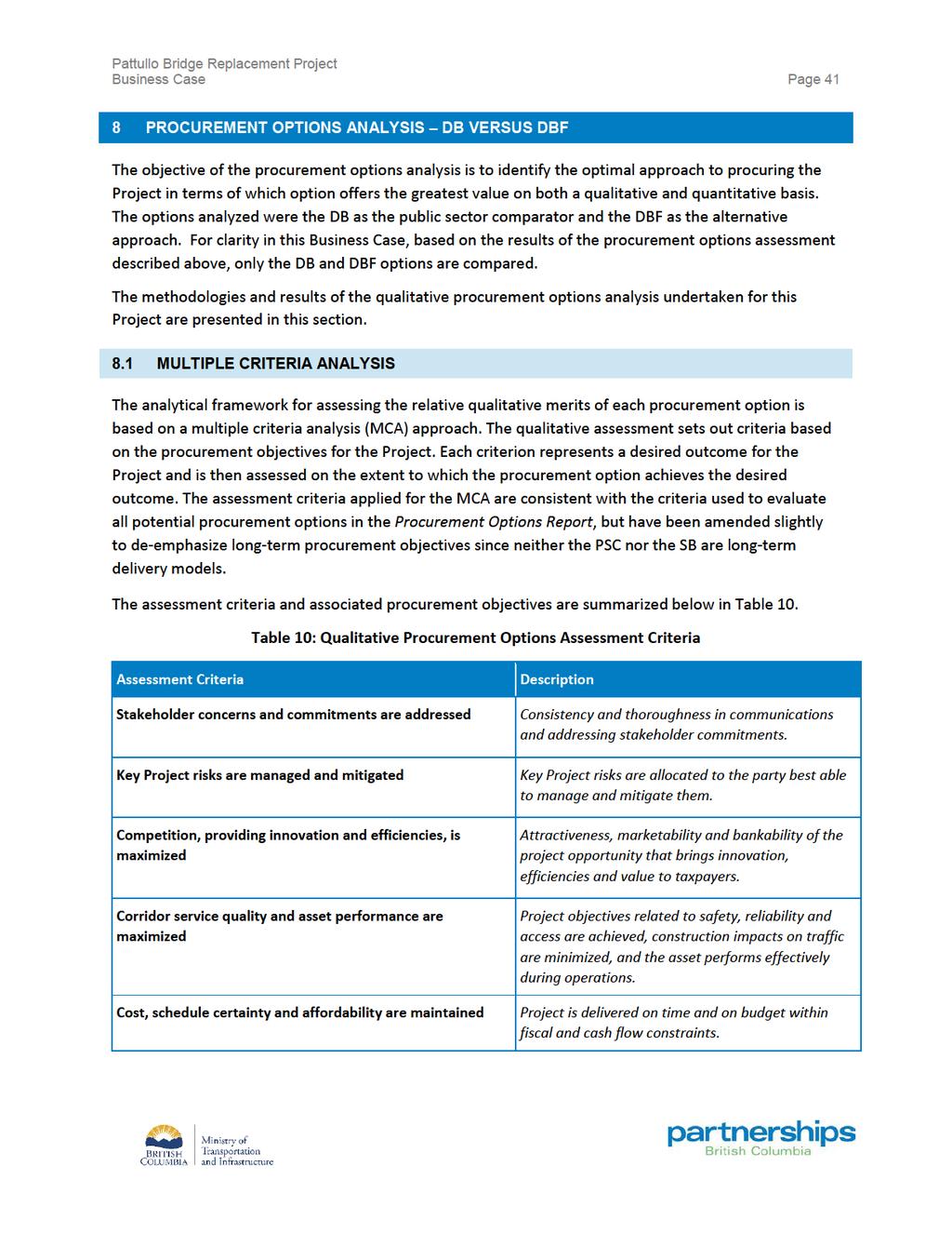
28 Business Case Page 22 counter-flow lane that changes direction depending on the flow of peak period traffic. At a high level, the retrofit program is expected to include strengthening of structural elements such as piers and the superstructure, bridge foundation improvements, additional scour protection and marine vessel impact protection, and a full deck rehabilitation. Rehabilitation of the existing bridge would not be expected to fully address the Project objectives. Option 1 (Minimum Scope): This option replaces the existing bridge with a new four-lane bridge with only minor changes to effectively connect to adjacent road networks at both sides of the crossing. Option 2 (Moderate Scope A): This option provides greater connectivity between the new bridge and adjacent road and multi-modal networks, including improved pedestrian and cycling facilities, improved access and connections in New Westminster, a new partial interchange in Surrey to provide free flow traffic movements between Scott Road, King George Boulevard, and the new bridge and minor intersection improvements made to the Bridgeview/King George Blvd intersection to improve traffic operations. No direct connections to/from Highway 17 are provided. Option 3 (Moderate Scope B): This option is the same as Option 2 on the New Westminster side of the crossing, but provides a direct southbound ramp from the bridge to connect to westbound Highway 17 in Surrey, grade-separation at the existing signalized intersection at Highway 17 and Old Yale Road, and improvements to Bridge Road. Option 4 (Full Scope): This option encompasses the most extensive scope of network connectivity works by including all network improvements identified in Options 1 to 3, plus full movement connections to Highway 17 provided via a new Scott Road Extension. 4.4 MAE FRAMEWORK AND RESULTS This analysis utilizes the five accounts used to evaluate transportation projects. Each is described below, including the qualitative and quantitative measures chosen to best reflect the individual characteristics and goals of this project. The overall results of the MAE analysis are summarized in Table 5.
29
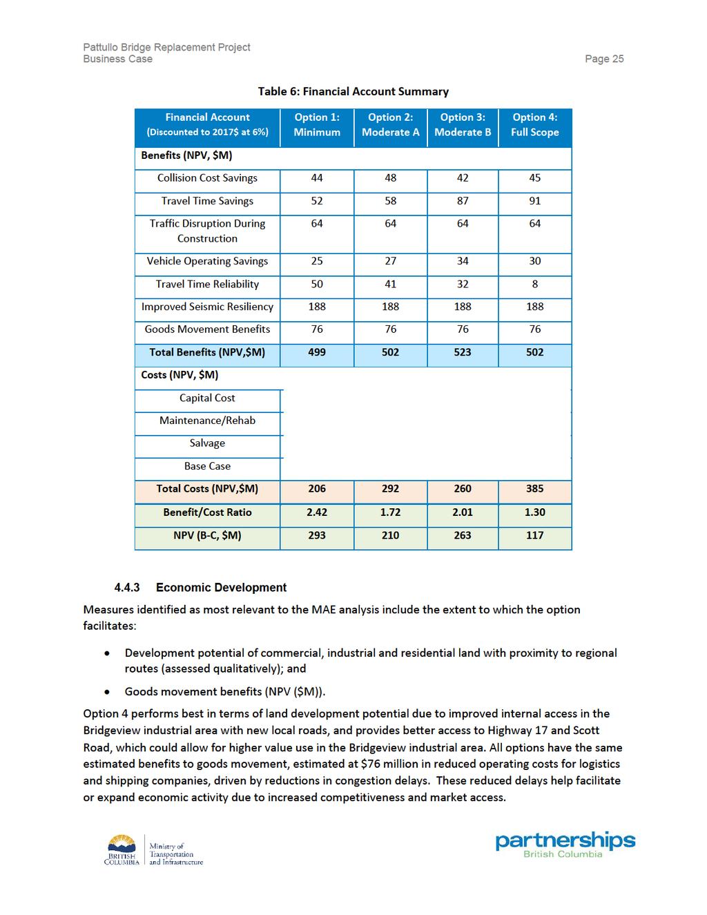
30 Business Case Page 24 Option 3 (Moderate B Scope) provides the highest quantified benefits to road users as indicated in Table 6. Option 4 provides improved regional connectivity through the provision of direct connections between the bridge and all major routes on both sides of the bridge, improved local access in the Bridgeview industrial and residential neighbourhoods, and Bridge Road access reliability is improved through the provision of secondary access routes, such as the Scott Road Extension and the southbound bridge off-ramp to westbound Highway 17. Preliminary traffic analysis indicates the Scott Road extension, included in Option 4, will result in unacceptable queuing onto Highway 17 during the AM peak. Option 4 attracts more demand to the bridge, and thus has less Travel Time Reliability Savings as compared to the other options Financial This account measures the net present value cost of each option relative to the base case and encompasses capital, operating, maintenance, and rehabilitation of all capital works. The ratio of quantified benefits to project costs, on a net present value, incremental (to base case) basis, provides the benefit-cost ratio (BCR) for each option. Option 1 offers the highest benefit cost ratio but the lowest quantified benefits due to the limited scope in network connections. Option 3 offers the highest quantified benefits and the second highest BCR, as indicated in Table 6.
31
32 Business Case Page Environment This account assesses the nature, degree and mitigation of environmental impacts associated with each option, relative to the base case. Quantitative measures include: Greenhouse gas emissions (GHG) (tonnes); and Regional vehicle kilometers travelled (VKT) savings (km). Qualitative measures include potential: On-land environmental effects for at-risk wildlife, habitat and native vegetation; On-land environmental effects for archaeological and heritage resources; In-river environmental effects for hydrology and morphology and fish and fish habitat; and Noise and vibration near residential areas. All options attract more traffic to the bridge than the three-lane Base Case. Option 4 attracts more demand and longer distance trips to the bridge, contributing to higher VKT and thus higher emissions than the other options. All options result in higher GHG emissions due to the higher VKT and congestion in all approaches. However, the incremental difference between the options and the Base Case is insignificant. Given the urban and industrial context for the existing bridge and proposed options, minimal incremental on-land environmental impacts are anticipated across all options. For the most part, these impacts are expected to be mitigated through commitments set out in the Environmental Assessment Certificate. In addition, while all new bridge options require in-water works, retaining the existing structure in the Base Case would also require in-water works to strengthen structural elements. Option 4 has the potential to increase noise and vibration due to an increase in commercial traffic using the Scott Road Extension on the north side of Bridgeview residential neighbourhood; therefore, it scores the worst against all options Social/Community This account captures the potential external effects of each option on the communities impacted, including their values, goals and specific group needs. For this project, those effects are understood in terms of a number of quantitative and qualitative measures. Quantitative measures include: Number of residences and businesses whose access is impacted (#); and Number of residential and business property takings required, both partial and full (#). Qualitative measures include: Alignment with both regional and community plans; and Community connectivity and modal integration for transit, pedestrians and cyclists Overall, Option 4 scores the best in terms of alignment with regional and community plans and benefits to the community due to the improved road connections and pedestrian and cyclist facilities; however, it also involves the most property impacts.

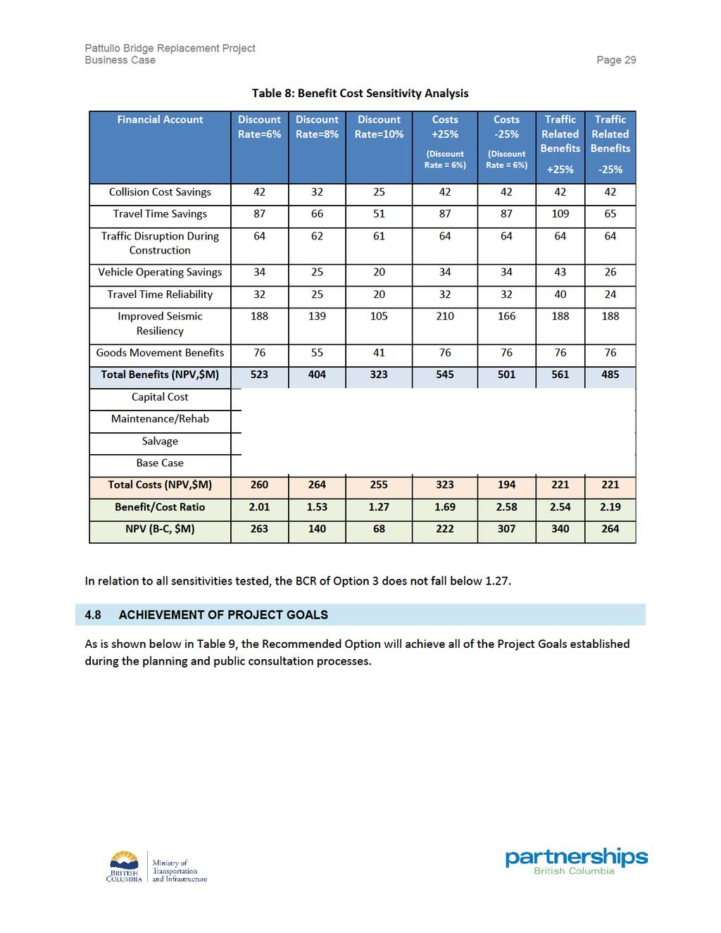
33 Business Case Page RECOMMENDATION Overall, Option 3 offers the highest quantified user benefits and the highest BCR among the options encompassing network enhancements on both sides of the crossing. Option 1 has the highest BCR but does not adequately address road network connectivity challenges on either side of the bridge; therefore it offers the lowest quantified user benefits. While Option 4 offers advantages in relation to qualitative measures represented by other MAE accounts, preliminary traffic analysis conducted following the removal of point tolls on Fraser River crossings indicates that proposed connections involving Scott Road and Highway 17 result in unacceptable queuing onto Highway 17 during the AM peak. Further traffic analysis is required to better understand these impacts. It is recommended that Option 3 be the preferred option for the Project to move to procurement (the Recommended Option). Option 3 is shown in Figure 8. Figure 8 - Recommended Option (Option 3) Map* *Reference Concept as of February CAPITAL COST ESTIMATE A capital cost estimate was prepared based on the physical asset scope described in Section 4.5 and detailed through concept drawings prepared by the Project team. Table 7 presents the estimated capital costs required to deliver the scope.
34
35
36
37 Business Case Page 31 PART B DELIVERY OF THE PROJECT This section of the Business Case describes the Project in terms of physical scope, operating period activities, and current status. From this point forward, the terms Recommended Option and Project are used interchangeably. TransLink led the Project through its conceptual development and planning phases. The Province will fund and build the Project. Upon completion, the Province will own and operate the asset.
38 Business Case Page 32 5 PHYSICAL ASSET SCOPE 5.1 OVERVIEW The Project will include a new, four-lane bridge. The Project will also include improved road connections on both sides of the bridge. More specifically, the Project includes the following key components: Design and construction of a new four-lane replacement bridge will provide: o o o A safer crossing with wider vehicle lane widths that conform to current roadway design standards and a centre median that separates traffic travelling in opposite directions; Pedestrian and cyclist facilities that are separated from traffic on both sides of the bridge; Consistency with current seismic, wind load and ship impact standards. New and enhanced connections with the local road network in municipalities on both sides of the bridge New Westminster and Surrey including: o o In New Westminster: Improvements to McBride Boulevard to accommodate the new bridge alignment; New direct Columbia Street on and off-ramps; and An improved Royal Avenue interchange, including an improved on-ramp from Royal Avenue. In Surrey: A new direct off-ramp from the bridge to westbound Highway 17; Old Yale Road grade separation and new Bridge Road connection; Improvements to Bridgeview Drive intersection with King George Boulevard Removal of the existing bridge after service commencement on the new bridge. The new bridge will be located just north and upstream of the existing bridge and continue to link the communities of New Westminster and Surrey. This route will tie into the existing road networks on both sides of the bridge and add a new connection to Highway 17. The Project is expected to open to the public in This timeline assumes a four-year design and construction period and is contingent upon procurement activities commencing in The new bridge will comply with modern roadway geometry standards, as well as standards for seismic events and ship impacts. It will support alternate modes of travel while providing reliable travel time and capacity to address current and forecasted needs. The constructability, expandability requirements and cost of the four-lane bridge concept are confirmed by the reference design.
39 Business Case Page OPERATION, MAINTENANCE, AND REHABILITION SCOPE Future operations, maintenance and rehabilitation for the new bridge and improvements will be the responsibility of the Ministry.
40 Business Case Page 34 6 PROJECT STATUS 6.1 CONSULTATION WITH STAKEHOLDERS AND THE PUBLIC TO DATE Pattullo Bridge Strategic Review (2013) As described in Section 4.1, a Strategic Review and extensive public and stakeholder consultation were led by TransLink from June 3 to 28, 2013, involving residents, businesses, local and regional stakeholders, and bridge users. Through this review, 25 bridge replacement options were narrowed down to six, which were ultimately reduced to two options following further analysis: a new four-lane bridge or a new six-lane bridge in the current location. In 2014, these two options were put forward to the Mayors Council on Regional Transportation for consideration. In its 2014 Regional Transportation Investments: a Vision for Metro Vancouver, the Mayors Council recommended that the replacement bridge should be a new, four-lane bridge, designed in a manner so as not to preclude potential future expansion to six lanes Community Connections Public Consultation Phase 1 and Phase 2 (2016) TransLink led two rounds of public consultation in 2016 to gather input on community connections, including road network improvements, as well as cycling and pedestrian access on both sides of the bridge in New Westminster and Surrey. A preliminary bridge design concept, including network connections, was developed based on extensive public consultation, technical review and financial considerations led by TransLink. This design concept was endorsed by the Mayors and Councils of both, Surrey and New Westminster in December The design concept has since been updated to reflect new technical information, including anticipated traffic disruption on Highway 17. Further traffic analysis is required to better understand the impact of changes in regional traffic patterns following the removal of point tolls on Fraser River crossings Current Consultation and Communications Planning A consultation and communications plan has been developed for the Project. The plan addresses the need to ensure that Aboriginal groups, local governments, stakeholders and members of the public are advised of the planning process. In addition, the plan will allow for the provision of appropriate information and venues to allow the public to provide meaningful input to the design process as appropriate. 6.2 TECHNICAL PLANNING Initial technical planning was undertaken in relation to the alternate solutions identified through the various public consultation processes. Since then, further technical analysis has been undertaken including: A geotechnical drilling program; Ongoing traffic modelling and forecasting;
41 Business Case Page 35 Investigation of utility relocation requirements; Both physical and numerical hydraulic modelling; Ongoing consultation and engagement with Aboriginal groups, local governments, Metro Vancouver, Port of Vancouver, and others; Property impact and acquirement assessments; Detailed studies of potential environmental, agricultural, recreational, and community effects; and Development of an EA Application submission to the BCEAO. 6.3 ENVIRONMENTAL REVIEW AND PERMITTING The Project is subject to review under British Columbia s Environmental Assessment Act. It is also subject to a Canadian Environmental Assessment Act, 2012 section 67 determination and permitting by the Vancouver Fraser Port Authority (VFPA), which will be supported by VFPA s Project and Environmental Review (PER) process. The BCEAO and VFPA have agreed to a harmonized environmental assessment process, led by BCEAO, which meets both federal and provincial environmental assessment review requirements. At the end of the environmental assessment review process, BCEAO and VFPA will come to separate decisions regarding issuance of an Environmental Assessment Certificate (EAC) and a PER permit, respectively, that would allow the Project to proceed. The first step of the environmental assessment process is the Application Information Requirements (AIR). The AIR is the identification of Valued Components (VC) to be studied and the areas within which the studies would occur. This is done through the Valued Components Selection Rationale Document (VC Document). As part of this process, Aboriginal groups, federal and provincial agencies, and municipalities were consulted. The BCEAO also invited public and stakeholder comment on this document though a public comment period which closed on July 27, The environmental submission will include studies and potential mitigation for review by BCEAO and VFPA. The overall Environmental Assessment will also be coordinated with technical requirements, property requirements, affected municipalities, Aboriginal groups and others including utilities, railways and the public. As part of the environmental permitting process, the federal, provincial, and municipal authorities will be issuing site approval permits. These permits will detail requirements related to the design and construction phase of the project. 6.4 MUNICIPAL LIAISON The project team maintains regular contact with elected officials from both Surrey and New Westminster, and senior staff including City Managers and municipal technical staff. The municipalities have been invited by the EAO to participate in a project working group (the Working Group).
42 Business Case Page ABORIGINAL GROUPS The following Aboriginal groups were contacted in order to initiate consultation in accordance with direction provided by the project s regulators (EAO and the VFPA). These groups have also been invited by the EAO to participate in the Working Group: Cowichan Tribes; Halalt First Nation; Katzie First Nation; Kwantlen First Nation; Kwikwetlem First Nation; Lake Cowichan First Nation; Lyackson First Nation; Musqueam Nation; Penalekut Tribe; Semiahmoo First Nation; Squamish Nation; Stz uminus First Nation; Tsawwassen First Nation; and Tsleil-Waututh Nation. Aboriginal groups who have engaged in consultation with the Project team or through the EAO's Working Group have been provided with information about the Project and the Environmental Assessment. The Ministry will continue to consult with Aboriginal groups through the Environmental Assessment process and project implementation. As required under the regulatory process, the proposed consultation is documented in an Aboriginal Consultation Plan that was developed in consultation with Aboriginal groups. This plan was submitted by TransLink to the EAO within 60 days of issuance of the EAO s Section 11 order (August 8, 2017), as required by the Environmental Assessment process. The Section 11 order specifies the scope, procedures, and methods by which the review must be conducted. 6.6 COMMUNITY BENEFITS POLICY Work is underway to develop a new provincial community benefits policy framework. The new policy will be implemented as part of the Project.
43 Business Case Page PROPERTY An initial property strategy has been prepared by the Project s property team. This includes an assessment of the preliminary requirements of both temporary and permanent lands. These requirements will be continually updated as the reference concept is refined. 6.8 UTILITIES Work is underway to define the requirements for relocation and accommodation of utilities. Discussions have been initiated with the respective agencies including FortisBC, Metro Vancouver, telecommunications, and municipal utilities. 6.9 RAILWAYS The bridge will be located just upstream of the New Westminster Rail Bridge, which is owned by Public Works and Government Services Canada (PWGSC). The Project team and PWGSC are in discussions to ensure that the integrity of the rail bridge is retained through construction and bridge removal. The Project team is also in discussions with CN Rail, the operator of the rail bridge, as well as Southern Rail, Canadian Pacific Rail and BNSF. Through these discussions, specific requirements of the railways in relation to the interface with Project construction will be identified.
44 Business Case Page 38 PART C PROCUREMENT DELIVERY MODEL OPTIONS ANALYSIS Part C presents the analysis and results of the detailed assessment undertaken to determine the optimal approach to procure the Project. This section concludes that the recommended procurement delivery model option for the Project is a Design Build Finance (DBF) procurement approach.
45 Business Case Page 39 7 APPROACH A detailed assessment of two preferred procurement delivery model options (one Public Sector Comparator (PSC) and one partnership delivery model, called a Shadow Bid (SB)) was undertaken for the Project. The results of this assessment inform the identification of a procurement approach to best meet the Project objectives and provide value to taxpayers. For additional detail on how the preferred procurement delivery model options were selected for this analysis, refer to the Procurement Options Report. The following sections describe the procurement options analysis. 7.1 PROCUREMENT OPTIONS IDENTIFICATION The procurement analysis begins with a discussion of the procurement objectives, followed by a description of different procurement options and considerations under both the traditional public sector procurement approach (Public Sector Comparator or PSC) and alternative approaches. The setting of objectives and considerations was carried out collaboratively and included key members of the Project team. Seven procurement options were initially identified as feasible for delivering the Project. The assessment of these options is summarized in the Procurement Options Report. The final recommendation was to further evaluate a traditional procurement approach (the PSC) and an alternative procurement approach that included partial private finance (the SB). They are: A Design Build (DB) contract; and A Design Build Finance (DBF) contract. The assessment highlighted a single DB contract encompassing design and construction activities as well as removal of the existing bridge, as the preferred public sector comparator. The DBF model, including partial private finance and encompassing design and construction activities and removal of the existing bridge, was identified as the preferred alternative procurement approach. A long-term contract involving private finance was also considered but was deemed less advantageous in relation to the criteria applied in the procurement options assessment. 7.2 PROCUREMENT OPTIONS ANALYSIS OVERVIEW The two shortlisted procurement options were analyzed and compared using both quantitative and qualitative assessment techniques. The comparative analyses included the following: Multiple Criteria Analysis (MCA) A qualitative evaluation method that compares the relative merits of each option in terms of how well it is expected to address the procurement objectives of the Project and provide value to taxpayers. Details are provided in Section 8.1; Risk Analysis A comprehensive list of risks is identified for each phase of the Project. For procurement options analysis, a select subset of these risks is quantified for each of the
46 Business Case Page 40 procurement options, highlighting the differences in value and allocation of risk inherent in each approach. This subset of quantified risks is an input to the financial modelling for comparative analysis and also assists in determining an appropriate overall contingency for delivery of the Project. A summary of the Risk Report for the project is provided in Section 8.2; Financial Modelling With inputs including the risk valuation, project financing assumptions, timing assumptions and project costs, a financial model is developed to simulate how the Province and a potential contractor would be expected to price the Project under each procurement approach. The financial modelling allows for differences in timing and costs associated with each procurement option to be evaluated and compared. Key financial modelling assumptions are provided in Section 8.3; Value for Money (VFM) Calculation The value for taxpayers dollars is estimated by comparing the net present cost (NPC, also referred to as net present value, or NPV) of the Project under the public sector procurement versus the alternative. This calculation and interpretation is set out in Section 8.4; and Market Sounding This activity includes a series of interviews held with sponsors and contractors chosen based on their previous involvement with relevant transportation project procurements in Canada and internationally. The results of this activity are summarized in Section 8.5.
47
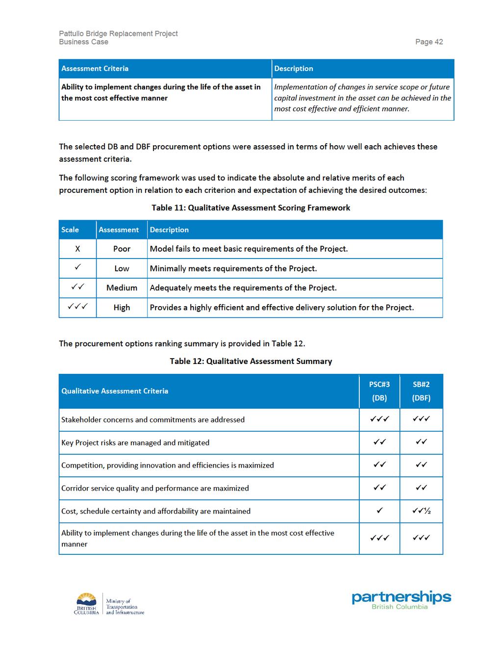
48
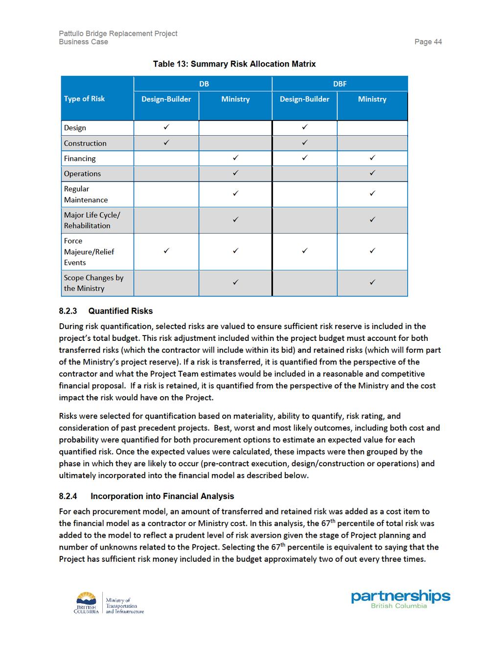
49 Business Case Page 43 The inclusion of private financing adds third party financial discipline to the Project and increases the likelihood of achieving on-time and on-budget delivery of the overall Project. As a result, DBF performs better than DB in the qualitative assessment. 8.2 RISK ANALYSIS Project risk is defined as the chance of an event or condition happening which could cause the actual project circumstances to differ from those assumed when forecasting project outcomes or objectives. Risk is an inherent part of any project, and to ensure a successful project outcome, risk must be effectively managed. The identification, allocation, measurement, and treatment of risk each form a key part in quantifying project risk. The ultimate goal is to identify and allocate project risks to the party best able to manage them at a reasonable cost to the project. An efficient or optimal allocation of risk between the Ministry and the contractor will ultimately provide the best value. The following subsections summarize the process and results of the risk analysis and quantification undertaken for the Project Risk Approach and Methodology A comprehensive assessment of Project-specific risks was conducted in accordance with the Provincial Government s risk management guidance developed in conjunction with the Province s Risk Management Branch (RMB) of the Ministry of Finance. These guidelines are generally consistent with the principles, framework and process described in the ISO 31000:2009 Risk Management Principles and Guidelines. This risk management guidance takes a systemic approach to risk, estimating the range of potential impacts on a risk-by-risk basis through the Project s planning, procurement, design and construction, and operating phases. Risk analysis is dynamic and should be revisited throughout the lifecycle of the project Risk Identification and Allocation The risk assessment process began with the identification of potential material risks and consequences that could impact the project during any of the stages of the Project s life cycle. This was completed through a series of risk workshops involving members of the project team and a variety of subject matter experts. The goal of the identification phase is to create a comprehensive list of risks which could affect (either positively or negatively), the project outcome. The identified risks were then categorized into either capital or operating risks depending on when they were expected to occur. Subsequently, each identified risk was evaluated to determine which party (the Ministry or the designbuilder) would be responsible under each procurement option. From the perspective of the Ministry, a risk can be transferred, shared, or retained with the private sector. Each specific risk is viewed through the lens of which party is best able to manage or mitigate the risk at the lowest cost. This allocation was completed for both the DB and DBF options and is summarized in Table 13 below.
50
51
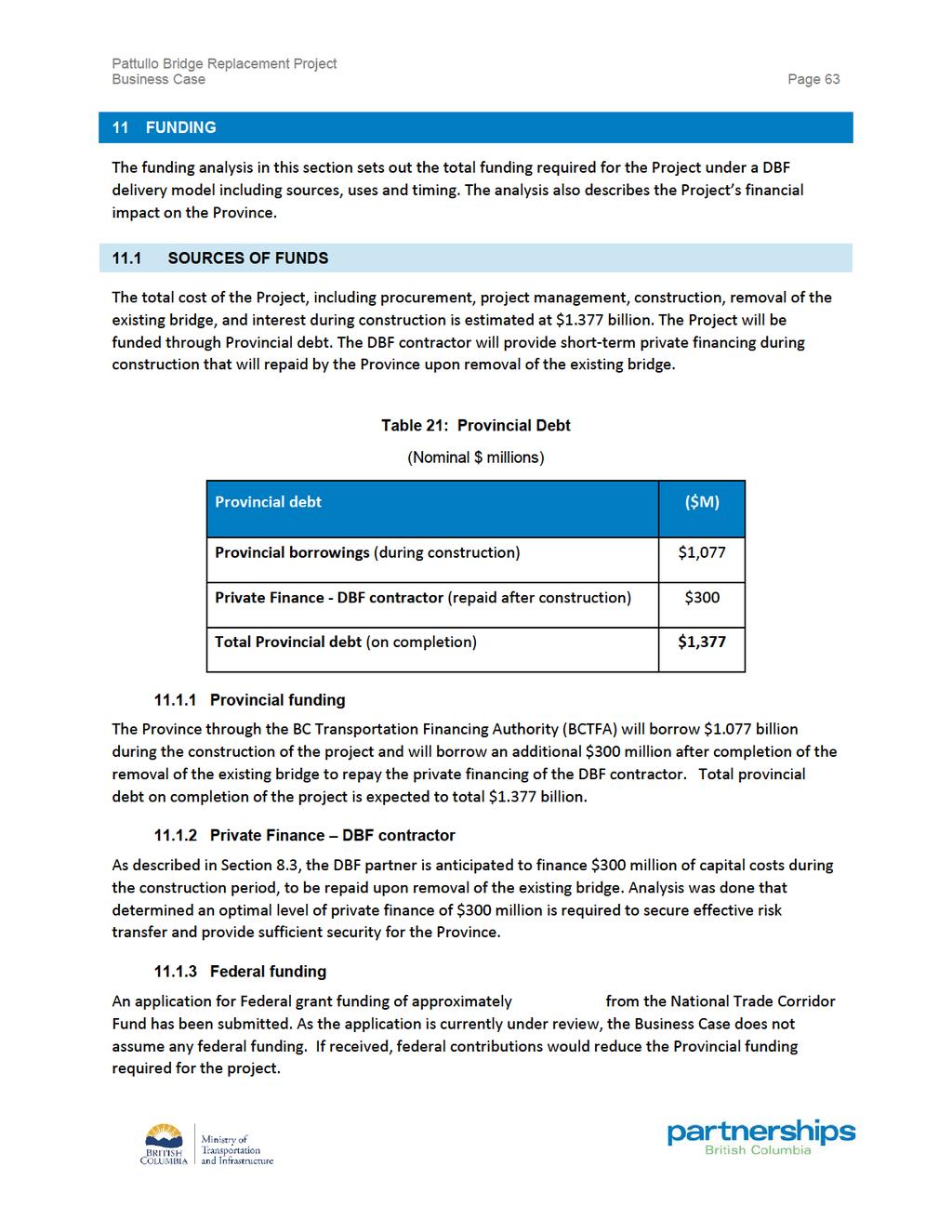
 and the SB (DBF). In addition, the Province s costs, including project management, were also estimated for each procurement option.")
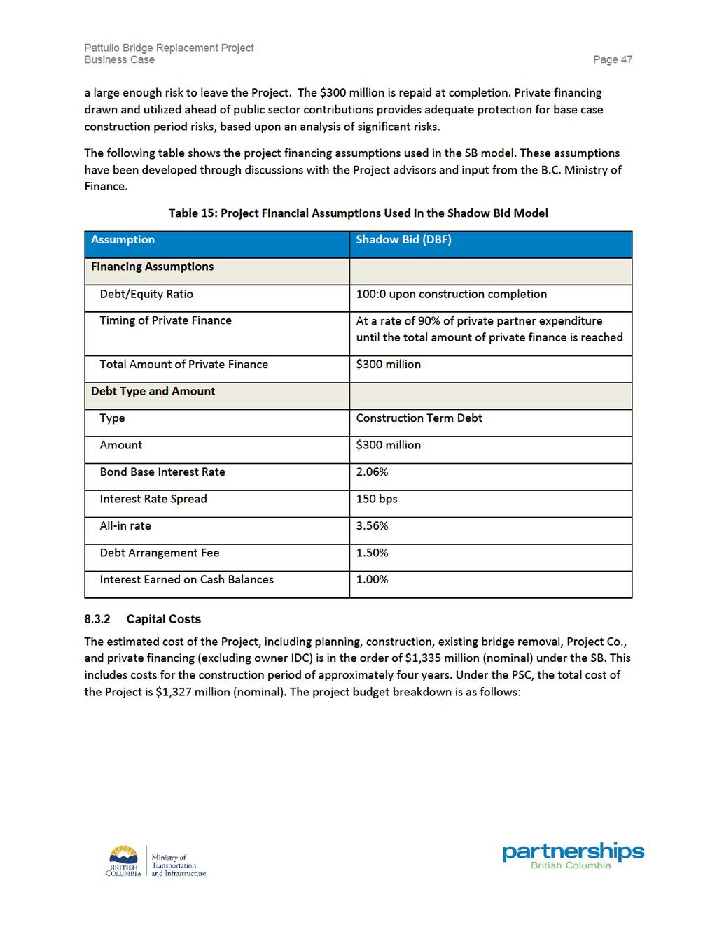
52 Business Case Page 46 Figure 9: Overview of VFM Approach To undertake the quantitative value for money assessment for this Project, a comprehensive risk analysis was conducted and risk-adjusted cash flow models were prepared for the PSC (based on a DB procurement) and the SB (DBF). In addition, the Province s costs, including project management, were also estimated for each procurement option. The financial models assume the same Project term in each case, and each option is required to be delivered to the same specifications and performance expectations. The results of this quantitative comparison between the PSC and the SB, together with the qualitative criteria, are used to determine the procurement method that provides the best overall value for money Project Financial Assumptions The SB and PSC were prepared based on an assumption that the design and construction of the new infrastructure and the removal of the existing bridge would start with a contract being awarded in the summer of GST is not included in the capital cost estimate. The financial model does not take into account GST movements since it is a working capital item and the value is immaterial to the analysis (for purchases, GST is paid on items and is subsequently refunded; for billings, GST is collected and then remitted). The SB assumes that the private sector will finance $300 million of the capital costs during the construction period. The $300 million in private finance is invested in the Project early to provide sufficient security in the form of unfunded value in the ground in the event construction challenges are encountered prior to substantial completion. This value is established based on the additional costs to the Ministry of procuring a contract to complete the infrastructure should the design-builder encounter
53
54
55
56
57
58 Business Case Page 52 The most recent market sounding confirmed that the expected timing of procurement and implementation does not pose significant obstacles to participation in the competition. While there are a number of large projects currently in or nearing procurement across Canada and in the United States, participants indicated they had adequate capacity to pursue all opportunities. Through both market soundings, market participants provided valuable feedback that will be considered further in the development of Project documentation and processes. Feedback included views on suggested technical investigative work, mitigation of risks in relation to third parties, traffic management, financing, timelines and the importance of ensuring clarity of expectations generally. There continues to be strong interest in the Project among virtually all market participants interviewed. The information gathered during both market soundings supported the Project team s anticipated Project planning, technical works, and procurement document development, including conducting geotechnical studies and liaising with utilities and other stakeholders.
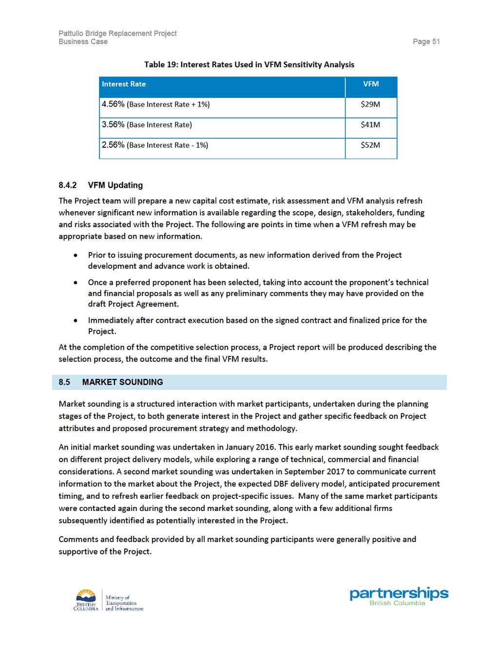
59 Business Case Page 53 9 RECOMMENDED PROCUREMENT OPTION Based on this qualitative and quantitative analysis, a DBF procurement approach, with $300 million in short-term private financing provided upfront, is recommended for the Project. The analysis shows that the DBF model will most comprehensively: Manage and mitigate key project risks; Maintain cost and schedule certainty; and Provide value for money (expected to be in the range of $41 million).
60 Business Case Page 54 PART D PROCUREMENT PLAN AND FUNDING Part D describes the procurement process to implement the Project, based on the DBF preferred procurement model. This section also discusses funding sources and provides a preliminary schedule for implementation.
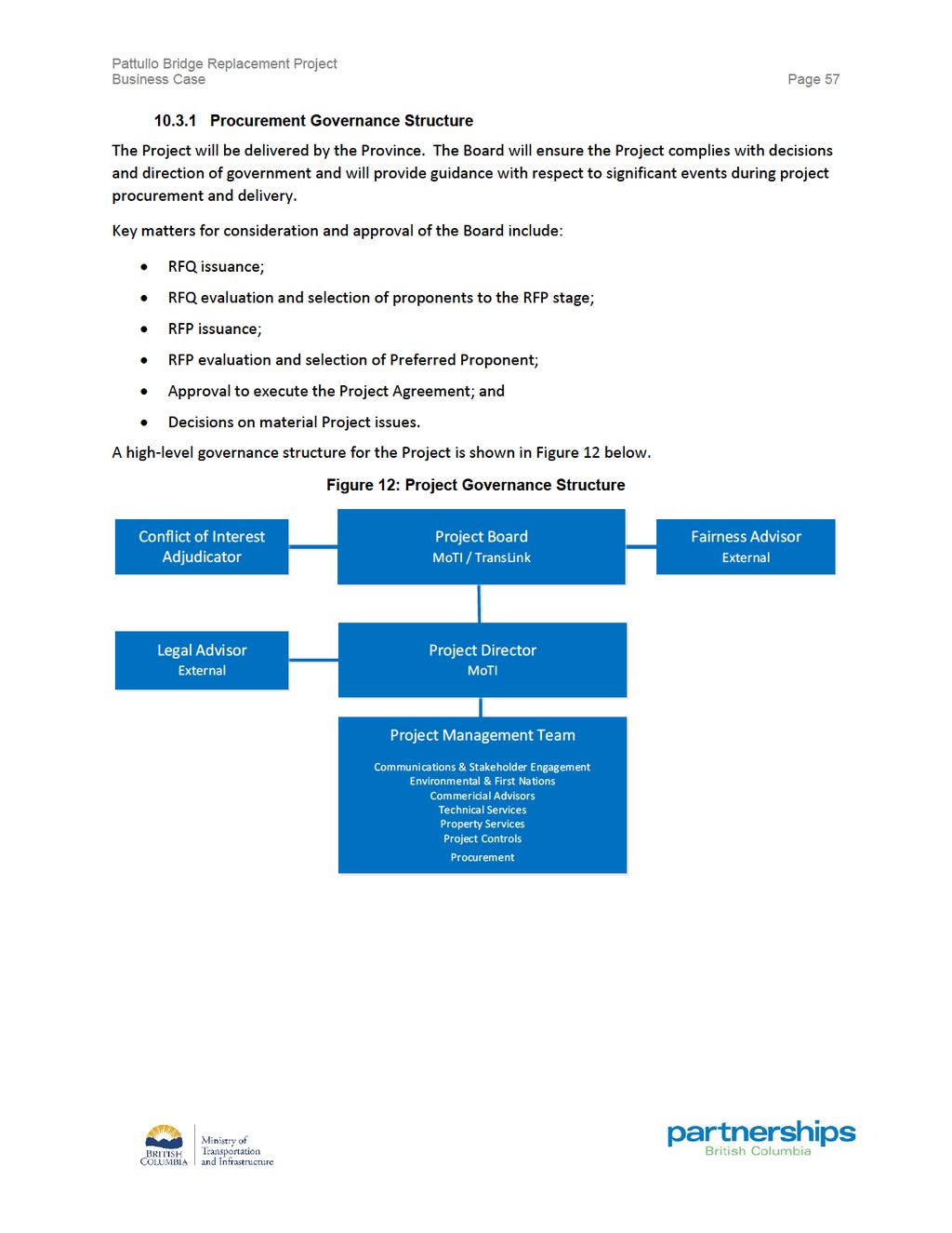
61 Business Case Page PROCUREMENT IMPLEMENTATION PLAN This section describes the policy and process framework in place to execute the procurement, the resources that have been dedicated, and the governance structure designed to ensure an open, fair and competitive procurement RECOMMENDED PROCUREMENT PROCESS Based on the DBF preferred procurement model selected for the Project, the recommended competitive selection process is a two-stage approach including a request for qualifications (RFQ) followed by a request for proposals (RFP) Request for Qualifications The RFQ is the first phase of the selection process. RFQ respondents are expected to demonstrate their experience, qualifications, capacity and capability to undertake the Project. They are evaluated on their experience and technical capability in design, construction, project management, quality management, environmental management and communications management. Based on this evaluation, a shortlist of up to three respondents will be invited to participate as proponents in the RFP phase of the selection process Request for Proposals The second stage of the procurement process is the RFP. The RFP package includes a detailed description of the Project, a draft contract, proposal submission requirements and details relating to how the proposals will be evaluated. The Project team anticipates implementing an interactive, two-stage RFP evaluation process such that proponents submit a technical proposal, which is evaluated based on the Province s stated performance requirements set out in a draft contract, in advance of their financial proposal. All proponents submitting technical proposals satisfying the RFP requirements will be invited to submit a financial proposal. Throughout the procurement process, a Fairness Advisor is retained to monitor the selection process and will provide a written report at the conclusion Post-Procurement Contract Administration The Province s implementation team will protect the Province s interests and ensure the Project is designed and constructed in accordance with the contract requirements PROJECT SCHEDULE This schedule represents key activities and milestones critical to advancing the Project through to construction.
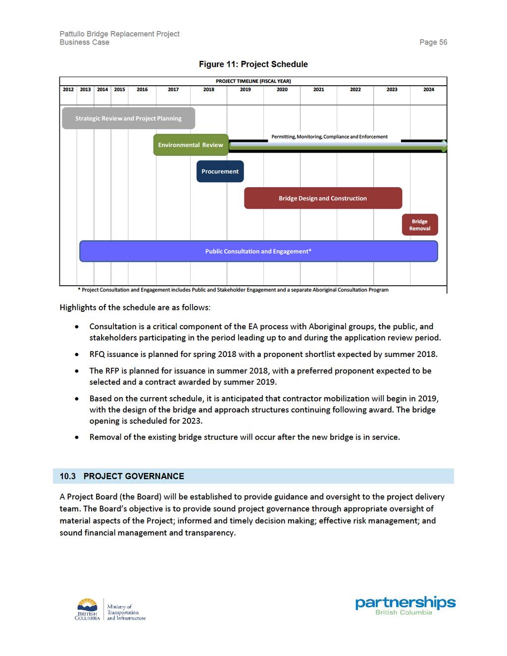
62
63
64 Business Case Page PROJECT STAKEHOLDER AND PUBLIC COMMUNICATIONS AND CONSULTATION Public Consultation Program The public consultation and engagement program in support of the project was designed to meet best practices, including providing multiple opportunities and methods for participation, reporting back on the feedback received and outlining how this input was considered by the project team. Replacement options for the aging Pattullo Bridge have undergone broad and extensive review, and there have been multiple opportunities for public input during the Pattullo Bridge Review Process and the current Pattullo Bridge Replacement Project. There have been many rounds of consultation on the bridge. Since 2013, there were three rounds of engagement and consultation led by TransLink. There are two rounds led by the BCEAO as part of the environmental assessment of the project. The graphic below outlines opportunities for public input since Figure 13: Public Input Opportunities Planning BC EAO Process Pattullo Bridge Review Community Connections Consultation Community Connections Phase 2 Consultation B.C. Environmental Assessment Process B.C. Environmental Assessment Process Joint review led by the City of New Westminster, the City of Surrey and TransLink Led by TransLink Led by TransLink Public Comment Period on the draft Application Information Requirements Public Comment Period on the Application for an EA certificate Complete Complete Complete Complete Planned June 3 28, 2013 June 13 July 11, 2016 October 3 31, 2016 June 26-July 27, 2017 Spring 2018 Pro-active community consultation and community relations programs will continue throughout the Project. The Project team will continue to meet with local governments, Aboriginal groups, Metro Vancouver, TransLink, key stakeholder groups and the general public throughout the delivery of the Project. On-going communications through the community relations program will continue to raise public awareness of the overall benefits of the Project. The Project will update stakeholders and the public on key milestones and events, and respond to inquiries on a timely basis. A key component of the community relations program will include a construction notification program.
65 Business Case Page ENVIRONMENTAL ASSESSMENT CONSULTATION Advisory Working Group The following government agencies, municipal and regional agencies, and Aboriginal Groups were invited by EAO and VFPA to become Advisory Working Group members for the Project, and have had the opportunity to review and comment on the draft VC Document: Provincial Agencies: Ministry of Forests, Lands, Natural Resource Operations and Rural Development (FLNRO) Ministry of Environment-Climate Action Secretariat Federal Agencies: Vancouver Fraser Port Authority (VFPA) Transport Canada Fisheries and Oceans Canada (DFO) Health Canada Public Works Canada Public Services and Procurement Canada Municipal and Regional Agencies: City of New Westminster City of Surrey Metro Vancouver Fraser Health Authority Aboriginal groups identified in Schedule B of the Section 11 Order 1 issued on August 8 th, 2017: Cowichan Tribes; Halalt First Nation; Katzie First Nation; Kwantlen First Nation; Kwikwetlem First Nation; 1 Aboriginal groups are listed in alphabetical order.
66 Business Case Page 60 Lake Cowichan First Nation; Lyackson First Nation; Musqueam Indian Band; Penelakut Tribe; Semiahmoo First Nation; Squamish Nation; Stz umunis First Nation; Tsawwassen First Nation; and Tsleil-Waututh Nation. The environmental, social, economic, heritage, and health components to be assessed as part of the Environmental Assessment Certificate Application (i.e. valued components or VCs), and the process followed in selecting and appropriately defining them, is described in detail in the VC Document. In addition, a formal public comment period was held in 2017 and a second is planned for 2018 as part of the BCEAO process BCEAO Environmental Assessment: Public comment period for the VC Document June 26 to July 26, 2017 B.C.'s Environmental Assessment Office (BCEAO) and the Vancouver Fraser Port Authority are coordinating the provincial-federal environmental assessment process for the Project. Prior to submission of an application (Application) for a certificate, BCEAO must first approve Application Information Requirements. Key to the Application Information Requirements is the identification of Valued Components to be studied and the areas within which the studies would occur. This public comment period conducted by the BCEAO and Vancouver Fraser Port Authority gathered input about the VC Document which will shape the scope and nature of environmental studies required as part of the Application for an Environmental Assessment Certificate (EAC). The EA process examines projects for potentially adverse effects within five key areas: Environment, Economic, Social, Heritage and Health. This public comment period followed the e-posting of the VC Document. The public and stakeholders had opportunities to attend open houses in Surrey and New Westminster, and to provide written comments to the BCEAO Environmental Assessment: Public Comment Period for the Application for EAC This later stage of environmental assessment consultation will be more detailed than the initial public comment period and the complete application will be presented for public review. The public comment period will focus on gathering public feedback regarding environmental effectsassessment studies, including mitigation, compensation related to specific impacts and proposed proponent commitments and assurances.
67
68
69
Pattullo Bridge Replacement Project. Cost Report
 Pattullo Bridge Replacement Project Cost Report January 2018 Cost Report Page i TABLE OF CONTENTS 1 PURPOSE... 1 2 BASIS FOR THE ESTIMATE... 2 2.1 Scope of the Works... 2 2.2 Scope of Capital Costs...
THAT Council adopt the Congestion Management Strategy as outlined in this report
 RR3 ADMINISTRATIVE REPORT Report Date: May 2, 2017 Contact: Winston Chou Contact No.: 604.873.7913 RTS No.: 011564 VanRIMS No.: 08200020 Meeting Date: May 16, 2017 TO: FROM: SUBJECT: Vancouver City Council
Appendix 1. Problem Identification for MoTI Business Cases
 Guidelines for Preparing MoTI Business Cases Appendix 1 Problem Identification for MoTI Business Cases Prepared By: Planning and Programming Branch Infrastructure Department BC Ministry of Transportation
Transportation and Works Department The Regional Municipality of York Yonge Street Newmarket, Ontario L3Y 6Z1
 TRANSPORTATION IMPACT STUDY (TIS) GUIDELINES FOR DEVELOPMENT APPLICATIONS Transportation and Works Department The Regional Municipality of York 17250 Yonge Street Newmarket, Ontario L3Y 6Z1 August, 2007
FRASER RIVER TRADE AREA MULTI-MODAL TRANSPORTATION NETWORK PLANNING STUDY
 FRASER RIVER TRADE AREA MULTI-MODAL TRANSPORTATION NETWORK PLANNING STUDY EXECUTIVE SUMMARY SEPTEMBER 2016 Submitted By: PARSONS EXECUTIVE SUMMARY With anticipated growth in trade between Canada and the
CITY OF VANCOUVER ADMINISTRATIVE REPORT. General Manager of Engineering Services in consultation with the Director of Current Planning
 CITY OF VANCOUVER ADMINISTRATIVE REPORT Date: September 1, 2005 Author: Dale Bracewell Phone No.: 604.871.6440 RTS No.: 5291 CC File No.: 8203 Meeting Date: September 20, 2005 TO: FROM: SUBJECT: Standing
To provide an update on the progress of the Peel Goods Movement Task Force and Peel Goods Movement Strategic Plan.
 8.4-1 REPORT Meeting Date: 2014-06-26 Regional Council For Information DATE: June 17, 2014 REPORT TITLE: PEEL GOODS MOVEMENT STRATEGIC PLAN UPDATE 2014 FROM: Dan Labrecque, Commissioner of Public Works
Bowinn Ma MLA North Vancouver-Lonsdale
 January 1, 2018 Mayor and Council City of North Vancouver 141 W. 14 th St North Vancouver, BC V7M 1H9 Bowinn Ma MLA North Vancouver-Lonsdale Dear City of North Vancouver Mayor and Council: As you are all
Transit Service Guidelines
 G R E AT E R VA N CO U V E R T R A N S P O RTAT I O N A U T H O R I T Y Transit Service Guidelines PUBLIC SUMMARY REPORT JUNE 2004 Greater Vancouver Transportation Authority TRANSIT SERVICE GUIDELINES
407 TRANSITWAY. Planning & Preliminary Design
 FROM EAST OF HIGHWAY 400 TO KENNEDY ROAD GWP #252-96-00 Public Information Centre #2 June 24 th and 29 th, 2010 Purpose of Public Information Centre #2 The first Public Information Centre (PIC #1) was
To provide an update on the progress of the Peel Goods Movement Task Force and the Peel Goods Movement Strategic Plan.
 9.2-1 REPORT Meeting Date: 2015-11-26 Regional Council For Information DATE: November 10, 2015 REPORT TITLE: REGION OF PEEL GOODS MOVEMENT STRATEGIC PLAN - 2015 STATUS UPDATE FROM: Dan Labrecque, Commissioner
3.6 GROUND TRANSPORTATION
 3.6.1 Environmental Setting 3.6.1.1 Area of Influence The area of influence for ground transportation consists of the streets and intersections that could be affected by automobile or truck traffic to
The Folded Interchange: An Unconventional Design for the Reconstruction of Cloverleaf Interchanges
 The Folded Interchange: An Unconventional Design for the Reconstruction of Cloverleaf Interchanges I. ABSTRACT Keith A. Riniker, PE, PTOE This paper presents the Folded Interchange design and compares
DISTRICT OF NORTH VANCOUVER GUIDELINES FOR THE DEVELOPMENT OF CONSTRUCTION TRAFFIC MANAGEMENT PLANS
 DISTRICT OF NORTH VANCOUVER GUIDELINES FOR THE DEVELOPMENT OF CONSTRUCTION TRAFFIC MANAGEMENT PLANS Construction Impact Mitigation Strategy Guidelines for Major Developments The District of North Vancouver
SEARs project justification and conclusion
 31 Project justification and conclusion This chapter presents a justification for the project and a conclusion to the environmental impact statement (EIS). The justification is based on the strategic need
200 th Street Interchange Review
 200 th Street Interchange Review September 7, 2001 Ministry of Transportation 200 th Street Interchange Review September 7, 2001 Prepared by Dirk Nyland P.Eng, Chief Engineer Ministry of Transportation
Shannon Noonan, City of Cambridge Don Drackley, IBI Group Scott Johnson, IBI Group PTSL
 100 175 Galaxy Boulevard Toronto ON M9W 0C9 Canada tel 416 679 1930 fax 416 675 4620 ibigroup.com Memorandum To/Attention From cc Shannon Noonan, City of Cambridge Don Drackley, IBI Group Scott Johnson,
GO RAIL NIAGARA SERVICE EXTENSION
 Business Case: Finch Avenue West Rapid Transit GO RAIL NIAGARA SERVICE EXTENSION INITIAL BUSINESS CASE Date: November, 2014 NOVEMBER 2015 Page 1 TABLE OF CONTENTS 1.0 Executive Summary...p.5 2.0 Introduction....p.6
City of Brantford Chapter 3 TABLE OF CONTENTS
 Chapter 3 The Land Use & Transportation Connection TABLE OF CONTENTS 3.1 THE LAND USE & TRANSPORTATION LINK... 1 3.2 POPULATION & EMPLOYMENT GROWTH FORECASTS... 3 3.2.1 Proposed Places to Grow Plan Forecasts
Sunrise Project South I-205 Corridor Improvement Project
 Sunrise Project South I-205 Corridor Improvement Project January 24, 2007 Sunrise and I-205 Project Summary Conclusions Sunrise Scoping Study Key Results South I-205 Scoping Study Key Results South I-205
TravelSmart: Planning for Sustainable Urban Transportation
 Case Studies in Sustainable Transportation KAMLOOPS, BRITISH COLUMBIA CASE STUDY 3 TravelSmart: Planning for Sustainable Urban Transportation Organization City of Kamloops Transportation Department, Community
Final Recommendations Identification of Improvements, Strategies, and Solutions
 Identification of Improvements, Strategies, and Solutions Prepared by: December 2015 TABLE OF CONTENTS 1. Introduction... 1 1 2. Freight Policy Recommendations... 2 1 3. Freight Infrastructure Recommendations...
A Monitoring Strategy for Active Transportation Pilot Projects
 A Monitoring Strategy for Active Transportation Pilot Projects Amy Ibrahim, P.Eng. Ontario Ministry of Transportation, Provincial Highway Management Division Ray Bacquie, P.Eng. Cole Engineering Group
RURAL RESIDENTIAL COMMUNITY ROLE COUNCIL ROLE RURAL RESIDENTIAL ALL COMMUNITIES
 Orderly and Efficient Land Use Align land use, development patterns, and infrastructure to make the best use of public and private investment. Discourage future development of rural residential patterns
Woodburn Interchange Project Transportation Technical Report
 Final Report Woodburn Interchange Project Transportation Technical Report Prepared for Oregon Department of Transportation April 212 Prepared by DKS Associates Contents Methodologies... 4 Volume Development...
1 RICHMOND HILL CENTRE / LANGSTAFF URBAN GROWTH CENTRE - TRANSPORTATION STUDY
 Report No. 4 of the Transportation Services Committee Regional Council Meeting of April 22, 2010 1 RICHMOND HILL CENTRE / LANGSTAFF URBAN GROWTH CENTRE - TRANSPORTATION STUDY The Transportation Services
Jim Alexander Director of Design and Engineering, Southwest Light Rail Transit Project
 Memorandum Date: January 15, 2014 To: CC: From: Subject: Jim Alexander Director of Design and Engineering, Southwest Light Rail Transit Project Paul Danielson, P.E. Project Manager, Southwest Light Rail
Project Report: Achieving Value for Money. Port Mann/Highway 1 Improvement Project
 Project Report: Achieving Value for Money Port Mann/Highway 1 Improvement Project March 2011 Purpose of this Document This report describes the need for the Port Mann/ Highway 1 Improvement Project, and
Re: EX8.12 F.G. Gardiner Expressway Strategic Rehabilitation Plan Procurement Strategy
 Re: EX8.12 F.G. Gardiner Expressway Strategic Rehabilitation Plan Procurement Strategy Presentation to Executive Committee September 21, 2015 1 Overview Project Background Procurement Options Analysis
Stage One Reference Design Enhancements. Date: 2 October Cabinet-in-Confidence
 Stage One Reference Design Enhancements Date: 2 October 2013 Introduction This paper provides further information regarding the proposed enhancements to the Reference Design that have been identified since
Chapter 10 Goals, Objectives + Policies
 Chapter 10 Goals, + Policies Warehouse on Nestle Way near I-78 114 115 10.1 ESTABLISHMENT OF CONSISTENT GOALS 10.2 NATIONAL FREIGHT GOALS The Lehigh Valley s freight transportation investment decisions
District of North Vancouver Construction Traffic Management Plan Guidelines
 District of North Vancouver Construction Traffic Management Plan Guidelines The District of North Vancouver is committed to ensuring that the disruptions to the community and traffic associated with construction
1.1 Purpose of the Project
 Chapter 1 Purpose and Need for East Link Project 1.1 Purpose of the Project The purpose of the East Link Project is to expand the Sound Transit Link light rail system from Seattle to Mercer Island, Bellevue
Ottawa Transportation Master Plan 2013
 Introduction Ottawa s 2013 Transportation Master Plan (TMP) update sets a new standard for sustainable transportation planning in Canada. The plan, unanimously approved by Ottawa City Council, sets forward
APPENDIX B. Public Works and Development Engineering Services Division Guidelines for Traffic Impact Studies
 APPENDIX B Public Works and Development Engineering Services Division Guidelines for Traffic Impact Studies Revised December 7, 2010 via Resolution # 100991 Reformatted March 18, 2011 TABLE OF CONTENTS
CITY OF JACKSONVILLE 2030 MOBILITY PLAN STUDY UPDATE GOALS, OBJECTIVES, AND PERFORMANCE MEASURES PREPARED FOR: CITY OF JACKSONVILLE
 CITY OF JACKSONVILLE 2030 MOBILITY PLAN STUDY UPDATE GOALS, OBJECTIVES, AND PERFORMANCE MEASURES 3.20.2017 PREPARED FOR: CITY OF JACKSONVILLE 55 Railroad Row White River Junction, VT 05001 802.295.4999
Peter Klitz Senior Planner Transit Network Management TransLink (Metro Vancouver)
") Opening the Black Box to Shed Light on TransLink s Network Management Process Peter Klitz Senior Planner Transit Network Management TransLink (Metro Vancouver) Metro Vancouver s Transportation System Bus
Opening the Black Box to Shed Light on TransLink s Network Management Process Peter Klitz Senior Planner Transit Network Management TransLink (Metro Vancouver) Metro Vancouver s Transportation System Bus
PROJECT SCOPING PHASE ~ SCOPE OF SERVICES MAIN STREET BRIDGE OVER WINOOSKI RIVER CITIES OF BURLINGTON & WINOOSKI VERMONT
 PROJECT SCOPING PHASE ~ SCOPE OF SERVICES MAIN STREET BRIDGE OVER WINOOSKI RIVER CITIES OF BURLINGTON & WINOOSKI VERMONT PROJECT DESCRIPTION McFarland-Johnson, Inc. (MJ) has prepared this proposal to perform
URBAN CENTER COMMUNITY ROLE COUNCIL ROLE ALL COMMUNITIES URBAN CENTER
 Orderly and Efficient Land Use Align land use, development patterns, and infrastructure to make the best use of public and private investment. Plan for forecasted population and household growth at average
TRANSPORTATION 101 Today and Tomorrow. Moving People and Goods
 TRANSPORTATION 101 Today and Tomorrow Moving People and Goods What is the Transportation Commission? An independent, seven-member body of citizens appointed by the Governor for six-year terms and representing
Project Initiation Form
 Meeting Date: The Project Initiation Form should be completed in conjunction with the Level 2 Screening Form. Process Leads and/or Planners should complete the Project Initiation Form to document coordination
Welcome. Metro North Transmission Project Burnaby Community Information Open House March 8, About the Metro North Transmission Project
 Welcome Metro North Transmission Project Burnaby Community Information Open House March 8, 207 Thank you for attending this Community Information Open House about the Metro North Transmission Project.
September Public Meetings. Developing a Blueprint for the Corridor
 September Public Meetings Developing a Blueprint for the Corridor Study Background Study initiated by the Commonwealth Transportation Board (CTB) and administered by VDOT in association with VDRPT. Addresses
Airport Road from 1 km North of Mayfield Road to 0.6 km North of King Street Public Information Centre #1
 Municipal Class Environmental Assessment Airport Road from 1 km North of Mayfield Road to 0.6 km North of King Street Public Information Centre #1 Date: Thursday, June 20, 2013 Time: 6:30 p.m. 8:30 p.m.
CITY OF LETHBRIDGE TRAFFIC IMPACT STUDY GUIDELINES
 CITY OF LETHBRIDGE TRAFFIC IMPACT STUDY GUIDELINES March 2008 0526 TABLE OF CONTENTS Section Contents Page 1.0 INTRODUCTION 1 1.1 Traffic Impact Study 1 1.2 Need and Justification 2 1.3 Purpose of Guidelines
Exposition Light Rail Transit Project
 Exposition Light Rail Transit Project Downtown & Mid-Corridor Project Status Update Meeting Holman United Methodist Church Thursday, July 23, 2009 Phase 1 Project Description 8.6 mile corridor from Downtown
Active Risk Management - Charles River Basin
 Protecting, Promoting and Enhancing our Commonwealth: Assisting MassDOT to deliver projects on Time and on Budget Active Risk Management - Charles River Basin September 18, 2013 & Massachusetts Accelerated
Asset Management Performance Measures for Privatized Highway Concessions in British Columbia
 Asset Management Performance Measures for Privatized Highway Concessions in British Columbia Travis Gilbertson Geoplan Opus Consultants Inc. Victoria, British Columbia Canada 1 Outline 1. DBFO Projects
Congestion Management Process 2013 Update
 OVERVIEW OF THE DALLAS-FORT WORTH CONGESTION MANAGEMENT PROCESS Traffic Congestion In The Dallas-Fort Worth Region With the Dallas-Fort Worth (DFW) urban area as its center, the North Central Texas region
The Policies section will also provide guidance and short range policies in order to accomplish the goals and objectives.
 4 Goals & Objectives INTRODUCTION The 2015-2040 MTP preserves and promotes the quality of life and economic prosperity of the MAB by providing a transportation system consistent with the regional goals.
Mega Projects at WSDOT
 Mega Projects at WSDOT Managing multiple projects in major urban corridors LINEA LAIRD, WSDOT ASSISTANT SECRETARY ENGINEERING & OPERATIONS Presentation to Oregon State Legislature Congestion Work Group
Our proposal for an updated and expanded Creative Energy Network provides an exciting opportunity for our growing city.
 Welcome Our proposal for an updated and expanded Creative Energy Network provides an exciting opportunity for our growing city. As a valued Creative Energy customer and Vancouver resident, we want to provide
June 15, RE: WesPac LNG Project. To whom it may concern:
 June 15, 2015 WesPac Tilbury Marine Jetty Project Canadian Environmental Assessment Agency 410-701 West Georgia Street Vancouver, BC V7Y 1C6 Fax: 604-666-6990 CEAA.TilburyJetty-JeteeTilbury.ACEE@ceaa-acee.gc.ca
GEOMETRIC DESIGN CRITERIA for Non-freeway Resurfacing, Restoration, and Rehabilitation Projects
 GEOMETRIC DESIGN CRITERIA for Non-freeway Resurfacing, Restoration, and Rehabilitation Projects SEPTEMBER 1989 Arkansas State Highway and Transportation Department GEOMETRIC DESIGN CRITERIA for Non-freeway
Factor Potential Effects Mitigation Measures
 Natural Environment No impacts of provincial significance to the natural environment are anticipated for the rapid transit project. Other impacts and how they will be mitigated are outlined in the table
LAND USE POLICIES BY COMMUNITY DESIGNATION
 137 2040 138 Land Use Policies by Community Designation As discussed earlier in Thrive MSP 2040, the Council assigns a community designation to each city and township. This designation indicates the overall
Welcome to the Public Information Centre. Red Hill Business Park South Transportation Master Plan Addendum. June 25, :00 p.m. to 8:00 p.m.
 Welcome Welcome to the Transportation Master Plan Addendum June 25, 2012 6:00 p.m. to 8:00 p.m. Please sign-in Background In 2006 the City of Hamilton completed the North Glanbrook Industrial Business
2030 Transportation Policy Plan SUMMARY PRESENTATION. Land Use Advisory Committee November 15, 2012
 2030 Transportation Policy Plan SUMMARY PRESENTATION Land Use Advisory Committee November 15, 2012 Today s Topics Transportation Policy Plan (TPP) Requirements and Background Current TPP Policies, Issues
transportation BUSINESS PLAN
 Transportation BUSINESS PLAN 2014-17 Accountability Statement This business plan was prepared under my direction, taking into consideration the government s policy decisions as of February 12, 2014. original
METRO VANCOUVER MOBILITY PRICING INDEPENDENT COMMISSION FINAL TERMS OF REFERENCE. Revised - June 30, 2017
 METRO VANCOUVER MOBILITY PRICING INDEPENDENT COMMISSION FINAL TERMS OF REFERENCE Revised - June 30, 2017 Contents 1. POLICY CONTEXT... 3 2. PROBLEM... 3 3. MANDATE... 4 4. SUPPORTING REGIONAL OBJECTIVES
Interchange Workshop Report (August 2004)
") U.S. Highway 14 Corridor Study New Ulm to North Mankato Table of Contents Section Interchange Workshop Report (August 2004) Page 1. Introduction and Next Steps 1 2. Interchange Workshop Participants &
U.S. Highway 14 Corridor Study New Ulm to North Mankato Table of Contents Section Interchange Workshop Report (August 2004) Page 1. Introduction and Next Steps 1 2. Interchange Workshop Participants &
Port Alberni Trans-Shipment Hub (PATH) Feasibility Study
 Feasibility Study") www.cpcs.ca www.cpcs.ca Port Alberni Trans-Shipment Hub (PATH) Feasibility Study Expected Economic Impacts of PATH Project Prepared for: Prepared by: CPCS Ref: 13150 May 8, 2014 Acknowlegements and Disclaimers
www.cpcs.ca www.cpcs.ca Port Alberni Trans-Shipment Hub (PATH) Feasibility Study Expected Economic Impacts of PATH Project Prepared for: Prepared by: CPCS Ref: 13150 May 8, 2014 Acknowlegements and Disclaimers
ENVIRONMENTAL STUDY REPORT
 Strasburg Road Extension From North of Stauffer Drive To New Dundee Road Class Environmental Assessment ENVIRONMENTAL STUDY REPORT APPENDICES Volume II October 2013 Strasburg Road Extension Environmental
Re: EX16.1. Developing Toronto's Transit Network Plan to Attachment 6
 Re: EX16.1 Developing Toronto's Transit Network Plan to 2031 1 Contents 1. Executive Summary... 3 2. Background and Context... 7 Problem Statement:... 7 Decision History on Options Development... 8 Relief
Surrey Newton - Guildford Light Rail Transit Environmental and Socio-Economic Review DRAFT Terms of Reference
 Surrey Newton - Guildford Light Rail Transit Environmental and Socio-Economic Review Terms of Reference October 16, 2017 City of Surrey Client ref: MT01701P Prepared by: Surrey Newton - Guildford Light
DEVELOPMENT, ANALYSIS, AND DESIGN OF A NEW PARKWAY AT GRADE INTERSECTION (PAGI)
") 2013 ITE Western District Annual Meeting COCEPT DEVELOPMET, AALYSIS, AD DESIG OF A EW PARKWAY AT GRADE ITERSECTIO (PAGI) Lead Author: James M. Witkowski, PhD Supporting Author: Darrell Truitt, PE The Pima
2013 ITE Western District Annual Meeting COCEPT DEVELOPMET, AALYSIS, AD DESIG OF A EW PARKWAY AT GRADE ITERSECTIO (PAGI) Lead Author: James M. Witkowski, PhD Supporting Author: Darrell Truitt, PE The Pima
Bonnie Doon Grade Separation
 6. 2 Bonnie Doon Grade Separation Recommendation: That the April 18, 2017, Integrated Infrastructure Services report CR_4461, be received for information. Report Summary This report provides information
CHAPTER 4 GRADE SEPARATIONS AND INTERCHANGES
 CHAPTER 4 GRADE SEPARATIONS AND INTERCHANGES 4.0 INTRODUCTION The ability to accommodate high volumes of intersecting traffic safely and efficiently through the arrangement of one or more interconnecting
Building. Growing. Leading.
 London, Ontario Building. Growing. Leading. Unlocking the full potential of mid-sized cities Pre-Budget Submission to the Government of Ontario london.ca London, Ontario Introduction London is a leader.
THE PROJECT. Executive Summary. City of Industry. City of Diamond Bar. 57/60 Confluence.
 THE PROJECT A freeway segment ranked 6th worst in the Nation, with levels of congestion, pollution and accidents that are simply unacceptable and which have Statewide and National implications. Executive
Downtown Estes Loop Project Frequently Asked Questions
 May 15 th, 2015 Project Status 1) Has Alternative 1 already been selected? Is it a done deal? Response: The NEPA process will proceed with environmental analysis of both the No Action and Alternative 1.
Alberta Transportation Gas Tax Fund and Public Transit Fund Outcomes Report December 2009
 Alberta Transportation Gas Tax Fund and Public Transit Fund Outcomes Report December 2009 FINAL 1 Table of Contents Slide Number Executive Summary 3 Understanding the Outcomes Report 5 Measuring results
Regional Transportation Investments a Vision for Metro Vancouver
 Regional Transportation Investments a Vision for Metro Vancouver Mayors Council on Regional Transportation Richard Walton, Chair Mayor, District of North Vancouver Wayne Wright, Vice Chair Mayor, City
WELCOME IL 47. Community Advisory Group Meeting #5 Waubonsee Community College Wednesday, May 31, 2017
 WELCOME IL 47 Community Advisory Group Meeting #5 Waubonsee Community College Wednesday, May 31, 2017 MEETING PURPOSE MEETING AGENDA 1. Welcome/Introduction 2. Review Previous Public Involvement 3. Process/Schedule
Sabbir Saiyed, PhD., P.Eng. Manager, Transportation System Planning
 Sabbir Saiyed, PhD., P.Eng. Manager, Transportation System Planning February 5, 2016 Goods Movement is a Major Part of Peel s Economy Peel is one of Canada s most important freight hubs Close to major
SMART CITIES SMART GRID REFUELING INFRASTRUCTURE SENSORS, COMMUNICATIONS AND NETWORKING SYSTEMS HUMAN FACTORS
 SMART CITIES SMART CITIES Smart City development integrates multiple information and communication technology (ICT) and Internet of Things (IoT) solutions to manage a city s assets, optimize urban flows,
Draft Newell Highway Corridor Strategy SUBMISSION June 2014
 Draft Newell Highway Corridor Strategy SUBMISSION June 2014 1 This Regional Organisation of Councils speaks for over 236,000 people covering an area of more than 70,000sq kms comprising Bathurst Regional,
Current Trends in Traffic Congestion Mitigation
 Current Trends in Traffic Congestion Mitigation April 24, 2009 NCSL Spring Forum Washington, DC Jeff Lindley Associate Administrator, Office of Operations Federal Highway Administration U.S. Department
Building. Growing. Leading.
 London, Ontario Building. Growing. Leading. Unlocking the full potential of mid-sized cities Pre-Budget Submission to the Government of Canada london.ca London, Ontario Introduction London is a leader.
STRENGTHENING YOUR PORT S FINANCIAL STABILITY THROUGH DIVERSIFICATION
 STRENGTHENING YOUR PORT S FINANCIAL STABILITY THROUGH DIVERSIFICATION A Case Study of the Vancouver Fraser Port Authority s Natural Advantages and Diversification Strategies Larry Sawrenko, Director Finance
MONITORING IMPLEMENTATION AND PERFORMANCE
 12 MONITORING IMPLEMENTATION AND PERFORMANCE The FAST Act continues the legislation authorized under MAP-21, which created a data-driven, performance-based multimodal program to address the many challenges
CE 452 Traffic Impact Assessment
 CE 452 Traffic Impact Assessment 1 Why Required? New developments Produce/ attract new traffic Production: Residences Attraction: Shops, Offices, Schools, Hospitals etc. etc. Changes in traffic pattern
2 Purpose and Need. 2.1 Study Area. I-81 Corridor Improvement Study Tier 1 Draft Environmental Impact Statement
 2 Purpose and Need 2.1 Study Area Interstate 81 (I-81) is relied upon for local and regional travel and interstate travel in the eastern United States. It extends 855 miles from Tennessee to New York at
TCATS October 12-Michigan Works 5:30-7pm. NATS October 19-Niles District Library 6-7:30pm
 Goal Development Workshop TCATS October 12- Works 5:30-7pm NATS October 19-Niles District Library 6-7:30pm SAFETEA-LU Goals 2035 TwinCATS Goals 2030 TwinCATS Goals 1. Support the economic vitality of the
Caltrain Rapid Rail Plan
 TRANSPORTATION RESEARCH RECORD 1677 Paper No. 99-1328 31 Caltrain Rapid Rail Plan ANDREW BUTLER NASH The results of Caltrain s Rapid Rail Study are described. The purpose of the study was to develop a
ATTACHMENT A. Detailed Study Scope. I-66 (Inside) Multi-modal Study Scope
 Multi-modal Study Scope") ATTACHMENT A Detailed Study Scope I-66 (Inside) Multi-modal Study Scope EXECUTIVE SUMMARY The Virginia Department of Transportation (VDOT) seeks consultant assistance in identifying and evaluating a range
ATTACHMENT A Detailed Study Scope I-66 (Inside) Multi-modal Study Scope EXECUTIVE SUMMARY The Virginia Department of Transportation (VDOT) seeks consultant assistance in identifying and evaluating a range
Los Angeles County Congestion Reduction Demonstration Project
 Los Angeles County Congestion Reduction Demonstration Project frequently asked questions update #1 /august 2008 Los Angeles County Metropolitan Transportation Authority (Metro), California Department of
Geometric Design: Past, Present, and Future
 A2A02: Committee on Geometric Design Chairman: Daniel B. Fambro Geometric Design: Past, Present, and Future DANIEL B. FAMBRO, Texas A&M University JOHN C. COLLINGS, Delcan Corporation ROBERT DELLA VEDOVA,
West Transitway Extension Bayshore Station to West of Moodie Drive
 West Transitway Extension Bayshore Station to West of Moodie Drive Document 4 Assessment of Effects and Comparative Evaluation of Route Alternatives (AECERA) TABLE OF CONTENTS EXECUTIVE SUMMARY...V CHAPTER
Implementing Asset Management: WSDOT s Experience
 Implementing Asset Management: WSDOT s Experience 6 th National Conference on Transportation Asset Management Aaron Butters, P.E. Systems Analysis and Program Development Manager November 2, 2005 1 Highway
Appendix B Highway 407 Interchange Review - Cochrane Street Area
 Appendix B Highway 407 Interchange Review - Cochrane Street Area AECOM 300 ater Street hitby, ON, Canada L1N 9J2 www.aecom.com Memorandum To Michael May, P.Eng., Town of hitby Page 1 CC Subject Greg Hardy,
TEXAS FREIGHT MOBILITY PLAN 2017
 TEXAS FREIGHT MOBILITY PLAN 2017 Texas Transportation Commission September 28, 2017 Overview of the Texas Freight Mobility Plan 2016 Plan First multimodal freight mobility plan Identified freight network,
Purpose of the Countywide Transportation Plan SAN FRANCISCO COUNTY TRANSPORTATION AUTHORITY
 > 12 Purpose of the Countywide Transportation Plan SAN FRANCISCO COUNTY TRANSPORTATION AUTHORITY 13 SAN FRANCISCO S MULTIMODAL transportation network is crucial to San Francisco s status as a major regional
THE REGION S PLAN POLICY FRAMEWORK. August 2015
 THE REGION S PLAN POLICY FRAMEWORK August 2015 2 What is The Policy Framework? Cover photo credit: Sinan Sinharoy for Atlanta BeltLine, Inc. Atlanta is one of the world s most dynamic metropolitan areas,
APPENDIX A: BENEFIT COST ANALYSIS EXECUTIVE SUMMARY Table of Contents
 APPENDIX A: BENEFIT COST ANALYSIS EXECUTIVE SUMMARY Table of Contents Summary and Findings...3 Introduction...8 Methodology...9 Project Overview...10 Base Case - no build scenario...10 Build Alternative...10
DRAFT Nelson, Tasman and Marlborough (Top of the South) regional summary STATE HIGHWAY INVESTMENT PROPOSAL SEPTEMBER 2017
 regional summary STATE HIGHWAY INVESTMENT PROPOSAL SEPTEMBER 2017") DRAFT Nelson, Tasman and Marlborough (Top of the South) regional summary STATE HIGHWAY INVESTMENT PROPOSAL SEPTEMBER 217 REGIONAL TRANSPORT SYSTEM PROBLEMS AND OPPORTUNITIES Customer safety is compromised
DRAFT Nelson, Tasman and Marlborough (Top of the South) regional summary STATE HIGHWAY INVESTMENT PROPOSAL SEPTEMBER 217 REGIONAL TRANSPORT SYSTEM PROBLEMS AND OPPORTUNITIES Customer safety is compromised
Appendix D: Functional Classification Criteria and Characteristics, and MnDOT Access Guidance
 APPENDICES Appendix D: Functional Classification Criteria and Characteristics, and MnDOT Access Guidance D.1 Functional classification identifies the role a highway or street plays in the transportation
Niagara Region Transportation Master Plan Niagara-Hamilton Trade Corridor Technical Paper
 Niagara-Hamilton Trade Corridor Technical Paper 1. Purpose In the report to Council on the Regional Council Strategic Priorities Implementation Plan, pursuing Provincial commitment for the Niagara to Greater
Chapter 5: Highway Investment Direction and Plan
 5.1 Chapter 5: Highway Investment Direction and Plan 2040 2040 TRANSPORTATION POLIC PLAN version 1.0 5.2 Chapter 5: Highway Investment Direction and Plan Highway Investment Direction 3 Current Revenue
May April 2016 DRAFT. London s Rapid Transit Initiative. Business Case
 May April 2016 London s Rapid Transit Initiative Business Case DRAFT Table of Contents EXECUTIVE SUMMARY...i Economic Environmental Scan iii Key Benefits of London s Rapid Transit Initiative iii Plan