Traffic Operation Improvements at the Pembina-Emerson Port of Entry
|
|
|
- Douglas Burke
- 5 years ago
- Views:
Transcription
1 Traffic Operation Improvements at the Pembina-Emerson Port of Entry Brant Magnusson, P. Eng Traffic Operations Engineer Traffic Engineering Branch Manitoba Infrastructure and Transportation Derek Durant, P. Eng. Senior Functional Design Engineer Highway Planning and Design Branch Manitoba Infrastructure and Transportation David Lettner, BA, MPA, MCIP Senior Transportation Planner Systems Planning Branch Manitoba Infrastructure and Transportation Paper prepared for presentation at the Road Traffic Operations and Management Session of the 2013 Conference of the Transportation Association of Canada Winnipeg, Manitoba 1
2 ABSTRACT Major land-based ports of entry (POE s) are key surface transportation assets that process high annual vehicle volumes and are an integral component of surface transportation networks that support the safe, secure and efficient movement of people and goods between Canada and the United States. Historically, POE facilities were often developed with minimal inter-agency or binational co-ordination. Although bi-national mechanisms for improved infrastructure coordination at POE s have recently emerged, the Pembina-Emerson POE was modernized in the late 1990 s prior to these new collaborative processes. As a result of these less-than-desirably coordinated improvements, a number of traffic operation and related safety issues emerged almost immediately upon completion of the new POE facilities. In addition to the impact upon port efficiency and throughput, these issues also have broader safety and security consequences. Although a bi-national project team was undertaking a long-range planning study to address POE requirements to the year 2035, it became evident that there was an opportunity for Manitoba Infrastructure and Transportation to implement a cost effective series of immediate improvements for the southbound (SB) direction of travel that would not preclude any longrange planning initiatives. The proposed suite of immediate SB improvements were intended to address a number of traffic operation and related safety issues that had emerged at the Pembina- Emerson POE, particularly during peak periods, as vehicles approached and manoeuvred through the port. These improvements reflected improved advance notification, vehicle channelization and lane assignment strategies, as well as access management improvements at the existing duty free facility. These improvements were designed and constructed within a three year period for minimal cost and were expected to improve SB traffic operation and overall border plaza safety for a period of 5-10 years. These immediate SB improvements would be sufficient to address traffic operations at the POE until such time as the long-term improvements recommended in the POE concept plan were implemented. The SB improvements included as assessment of lessons learned regarding the modification of driver behaviour and regarding driver compliance with channelization and lane assignment strategies. 2
3 1.0 Introduction The development or improvement of land-based ports-of-entry (POE s) facilities and road infrastructure has not always occurred in a highly integrated inter-agency planning and decisionmaking environment. Prior to the September 2001 terrorist attacks on the United States, many land-based POE improvement projects proceeded with very little inter-agency coordination and required other agencies to adapt to plans in which they had minimal involvement or influence. The Pembina-Emerson POE is an example of where both US-Customs and Border Protection (CBP) and the Canada Border Services Agency (CBSA) facilities were completely rebuilt in the late 1990 s with very little inter-agency or bi-national consultation and coordination, particularly regarding highway infrastructure and traffic management considerations. Exhibit 1 illustrates the regional context of the Pembina-Emerson POE. As a result, it is not surprising that a number of traffic operations issues became apparent immediately after these new POE facilities were opened. These traffic operations issues intensified as the post NAFTA (1994) environment lead to significant increases in both passenger vehicle and commercial vehicle traffic throughout the first decade of the new millennium (Exhibit 2). Having largely been excluded or ignored in the initial POE planning and development process, transportation agencies were then placed under significant pressure by the public and stakeholder groups to address traffic related operational issues which continued to intensify with the increased traffic volumes. 2.0 Policy Context Land-based POE s are key elements of the surface transportation network connecting two countries. Delay and congestion at POE s add supply chain costs (time, financial, environmental) and have potential negative impacts on economic growth. The bi-national Beyond the Border declaration (February 4, 2011) signed by President Obama and Prime Minister Harper provides the over arching policy framework for moving toward a shared vision for perimeter security and economic competitiveness in North America. The Beyond the Border declaration recognizes the critical importance of land-based POE s in their dual role of sovereign security and North American supply chain efficiency. The Pembina-Emerson POE is the fifth (5th) ranked land-based POE between Canada and the United States in terms of two-way truck based trade ($17B in 2011) and has the largest trade values for a POE west of Detroit-Windsor. The Pembina-Emerson POE is ranked eighth (8th) in terms of total bi-directional truck movements. Total two-way truck based trade at the Pembina- Emerson POE is projected to grow to $27.5 billion by In 2012, total bi-directional movements exceeded 1 million vehicles with a auto / truck split and directional split by vehicle category. Total bi-directional traffic at the Pembina- Emerson POE is forecast to double and exceed 2 million vehicles by the year These projected volumes will retain the same auto-truck and directional vehicle split characteristics (Exhibit 3). 3
4 The trade significance of the Pembina-Emerson POE prompted Manitoba Infrastructure and Transportation (MIT) to initiate a planning study to develop a port improvement concept that would best address future requirements to the year This planning study was completed in 2012 in partnership with other transportation and border services agencies (North Dakota Department of Transportation-NDDOT, Canada Border Services Agency-CBSA, Customs and Border Protection-CBP and the General Services Administration-GSA) and recommended specific improvements to the southbound (SB) direction of travel by 2020 and northbound (NB) direction by In the interim, MIT recognized that there were some immediate improvements that could be implemented to address the most pressing traffic operation issues in the SB direction for roadways under the jurisdiction of the Province of Manitoba. Initial stakeholder consultations conducted in 2009 during the terms of reference development process for the Pembina-Emerson POE planning study led MIT to develop a suite of SB improvements which would address advance notification, undesirable weaving, and intersection conflict issues. These immediate SB improvements were intended as cost-effective interim solutions to provide some relief to traffic operational issues prior to longer-term SB improvements being implemented in Existing Conditions and Issues 3.1 Existing Geometric Conditions- PTH 75 Southbound Provincial Trunk Highway (PTH) 75 is a 4 lane divided expressway with a posted speed limit of 110 km/h, an annual average daily traffic count of 3000 vehicles per day and is a significant component of the National Highway System (NHS) in Manitoba. PTH 75 transitions from a 110 km/h speed limit to a 50 km/h speed limit as the SB cross-section expands from 2 lanes to 3 lanes within 1 km of the border. Within this transition area there is a major 4 leg intersection serving the weigh scale site and Provincial Road (PR) 243, a major 3 leg intersection providing access to the Town of Emerson (PR 200), two left hand accesses serving the CBSA facility, and two right hand accesses serving the duty free shop. Given this context, the potential of driver confusion and undesirable weaving manoeuvres in close proximity to the POE is high. 3.2 Discussion of Issues As noted in the introduction, the reconstruction of the POE in the 1990 s was undertaken with very little inter-agency consultation. Furthermore, traffic operations upstream from the custom plaza were not considered during the planning, design and construction of these projects by border services agencies (CBSA, CPB, and GSA). As such, significant traffic operational issues for vehicles approaching the POE from both the north and the south emerged immediately after the new CBP (1997) / CBSA (1999) facilities were constructed. Ironically, poor planning and infrastructure coordination also created operational issues for both CBP and CBSA regarding the efficient use of staff and primary inspection lane (PIL) infrastructure. 4
5 For MIT, traffic operation problems on PTH 75 SB approaching the POE resulted in repeated requests for action or improvements from the Manitoba Trucking Association (MTA), the duty free shop operator and the public. The SB traffic operational problems revolved around three primary issues: 1. Inadequate advance notification and poor lane assignment strategies 2. Weaving manoeuvres and conflicts between passenger vehicles and commercial trucks 3. Intersection conflicts at the duty free shop These issues are conceptually illustrated in Exhibit Inadequate advance notification and poor lane assignment strategies Ideally, traffic approaching the POE should be able to select the appropriate travel lane based both on the desired destination, and the PIL booth servicing protocol. In the case of SB traffic approaching the POE, drivers have five primary destinations; the POE itself, the weigh scale at PR 243, the Town of Emerson at PR 200, the duty free shop located on the right hand side of the highway, and the CBSA facility located on the left hand side of the highway. Furthermore, the geometry of the POE dictates that all commercial traffic must approach the facility from the right lane while passenger vehicles and bus traffic must use the center and/or left lane. A lack of communication during the POE development process meant that there was no opportunity to develop a comprehensive traffic management strategy to facilitate the orderly and efficient movement of traffic as it approached the POE. The legacy upstream signage (Exhibit 5) did not provide any information to facilitate the segregation of passenger and commercial vehicle traffic and was ineffective in allowing drivers to select the appropriate lane for any of the five above referenced destinations as they approached the border. As a result, MIT received repeated complaints regarding inadequate lane assignment signage. The majority of these complaints were related to periods of peak commercial vehicle activity. During these periods commercial traffic queues in the right hand lane can extend several kilometres back from the POE, while the center and left hand lanes continue to operate at close to free flow conditions. The lack of appropriate signage often resulted in passenger vehicles joining the end of the commercial vehicle queue in the mistaken assumption that they should also be in that lane. 2. Weaving Manoeuvres The impact of inadequate advance notification was also evident in reports of sudden weaving manoeuvres in the vicinity of the POE as poorly informed drivers made last second lane selection decisions. Fortunately, these weaving manoeuvres took place within the low speed (50km/h) section of the highway and collision reports were rare. Undesirable weaving manoeuvres also occurred due to a lack of forethought in the POE design with respect to export check parking requirements. Vehicles may have a requirement to have an export check conducted by the CBSA prior to leaving Canada, however; no formal export check 5
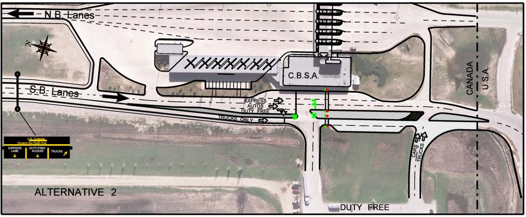
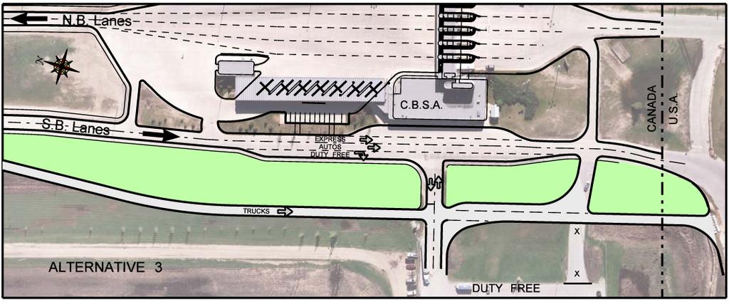
6 parking facility was established when the POE was redeveloped. In the absence of dedicated export check parking facilitates drivers have used various ad-hoc parking options, each with its own set of difficulties. Some drivers used the left hand slip parking lane adjacent to the CBSA facility. This parking spot was, however, frequently occupied by people wishing to visit the Duty Free Shop. When unoccupied this parking location worked well for passenger vehicles as it was adjacent to the appropriate through lane for passenger vehicles. Commercial vehicles would also use this slip lane when available; however, upon exiting these vehicles would be required weave across two lanes to re-enter the truck lane. This manoeuvre was particularly difficult to accomplish when there were truck queues present and would often result in a commercial vehicle blocking the passenger vehicle lanes. Drivers also parked their vehicles on the right hand commercial lane shoulder, exited their vehicle and crossed 3 lanes of traffic to enter the CBSA facility. In addition to the obvious pedestrian safety concerns, this also resulted in passenger vehicles weaving across the commercial vehicle lane upon departure in order to access the appropriate PIL. 3. Intersection Conflicts at the Duty Free Shop The largest source of complaints directed to MIT came from the operator and customers of the duty free shop. By virtue of its location, immediately north of the POE on the right hand side of the road, the entrance and exit were frequently blocked by truck queues during periods of high commercial vehicle activity. Efforts were made to address this issue through the use of Do Not Block Driveway signs, however; driver compliance was poor. As a result, drivers wishing to enter the Duty Free Shop were faced with a choice of either joining the back of the commercial vehicle queue (which would frequently extend 1-2 km back from the duty free shop entrance) or stopping in the center lane and making an attempt to force their way between stopped commercial vehicles to access the duty free shop entrance. Drivers exiting the duty free shop were forced to exit between closely spaced trucks in the commercial vehicle lane. In addition to the negative impact on duty free operator s business, this was also a serious safety concern due to the lack of adequate sight distance for both the exiting driver and for the through traffic in the center lane. 4.0 Alternative Development and Recommended Solution 4.1 Alternative Development Through a functional design process, MIT was able to identify a suite of measures that could be implemented at a relatively low cost without negatively impacting any future long-term improvements. In the development of alternatives stage of the functional design process, three alternative short-term plans ranging from minor enhancements to the construction of an entirely separate commercial truck lane located to the west of the existing highway were prepared. It was felt that the alternatives developed encompassed a range of viable solutions under the short term- 6
7 scenario that would address some of the operational issues that could be resolved by infrastructure improvements. Exhibit 6 illustrates the three alternatives described below. Alternative 1 Enhanced Status Quo This alternative was considered to be the minimum enhancement capable of addressing the two key issues impacting traffic operations at the POE. This alternative consisted of two key components: 1. Improved lane assignment signing on the approach to the POE. 2. Vehicle queue detection technology at the duty free accesses linked to enhanced signage flashing beacons) to warn truck drivers not to block the driveways. Alternative 2 Narrow Median and Traffic Signals This alternative was an enhanced interim solution which would address the need for improved lane assignment well in advance of the POE, the elimination of access (entrance and exit) blockages at the duty free shop, enhanced visibility at the duty free shop, and flexible lane assignment immediately north of the border compatible with future smart border initiatives. The key components of this alternative were: 1. Improved static lane assignment signing well in advance of the POE. 2. Flexible lane assignment signing immediately north of the POE in the form of an overhead variable message sign. 3. The construction of a median to separate commercial truck and passenger vehicle traffic in the vicinity of the duty free shop and the installation of traffic signals to safely accommodate the crossing of passenger vehicle and commercial truck traffic at the duty free shop access. 4. The use of vehicle queue detection technology at the duty free shop access linked to the traffic signals to eliminate the blockage of the access by commercial truck queues. Alternative 3 Wide Median This alternative was considered a high-end solution and was similar to one of the long-term alternatives that were developed in the planning study. This alternative relied on improved signage and significant geometric enhancements to improve operations in the SB direction of travel. The key components of this alternative included: 1. Improved static lane assignment signing well in advance of the POE. 2. Flexible lane assignment signing immediately north of the POE in the form of an overhead variable message sign. 3. The construction of an entirely separate truck lane approximately 30m to the west of the existing highway to resolve the operational issues related to the interaction of passenger vehicles and commercial trucks in the vicinity of the duty free shop and the CBP facility. 7
8 4. The reconfiguration of the duty free shop parking lot to a single access point and the provision of separate commercial truck and passenger vehicle parking at the duty free shop. 5. The installation of vehicle queue detection technology at the duty free shop access linked to enhanced signage (flashing beacons) to warn commercial truck drivers not to block the access. Although Alternative 3 was the most effective in addressing the key operational issues at the POE, it was determined that it was not feasible in the short term due to the limited room available to manoeuvre large commercial vehicles in the vicinity of the existing duty free shop. As a result this alternative was eliminated as a candidate for the short-term enhancement of the Pembina-Emerson POE. 4.2 Evaluation and Recommended Alternative Following the development of the three alternatives and an initial screening by key departmental staff, an evaluation of all alternatives was carried out based on both design criteria and implementation criteria. The results of this evaluation showed that Alternative 2 was the preferred alternative, Alternative 3 was ranked second and Alternative 1 ranked third. As noted earlier, Alternative 3 was determined to be non-viable in the short-term and only Alternative 2 and Alternative 1 were carried forward for cost estimates. Alternative 2 was selected as the preferred alternative and is illustrated in Exhibit IMPLEMENTATION The SB improvement strategy was phased in over three (3) years. In 2010, the GSA constructed pavements on the US side (CBP SB plaza approach) that would tie in with future MIT work. In 2011 fixed panel ground mount and overhead signs as well as an overhead Variable Message Sign (VMS) were installed to improve advance notification. In 2012 the pavements, intersection improvements, and a detection system were completed. 5.1 Improved Signage (2011) The signage improvements were aimed at segregating commercial and private vehicles into their appropriate lanes well in advance of the POE. This initiative involved the installation of series of ground mounted and overhead mounted signs ($50K) beginning 3 km in advance of the POE as well as the overhead VMS ($525K) under a cost sharing arrangement with the federal government (under the Border Information Flow Architecture pilot project). These signage improvements are illustrated in Exhibit 8. A unique feature of the VMS was that, in addition to providing advance notification of lane assignment by vehicle type (truck / auto), there was also the capability to assign private vehicles to either the left or center lanes to accommodate future smart border initiatives such as RFID and NEXUS document holders. By providing the flexibility to incorporate smart boarder initiatives in the longer term, the VMS has the added benefit of allowing MIT to provide real time 8
9 messages on any related border or downstream highway conditions (i.e. delay information, road closures due to weather or flood related conditions) through the MIT Operations Center. Communication protocols have been established between MIT, CBSA, CBP, and NDDOT to allow the partner agencies to request message changes to reflect conditions as required. 5.2 Geometric Improvements (2012) Detailed design of the proposed SB geometric improvements started in March 2011 and was completed in September The project was tendered and awarded in October 2011 with construction work beginning in July 2012 and completed in October The total contract value of the construction works for the geometric improvements (including the queue detection system described in 5.3 below) was approximately $1.2 million. At the south limit of project (the Canada/US border) the raised median and the truck lane tied seamlessly into the construction works that GSA (on behalf of CBP) had completed during the autumn of The geometric improvements included a commercial lane and channelization in the form of a narrow raised median to separate commercial truck and passenger vehicle traffic in the vicinity of the duty free shop, in order to further aid vehicle segregation downstream of the signage improvements. The design of the narrow raised median also included a channelized right-turn lane to accommodate drivers in passenger vehicles wanting to access the duty free facility. To address the absence of a formal export check facility for commercial operators, a truck export check parking lane was constructed on the west side of the truck lane between the duty free entrance and exit. At the exit from the duty free shop, a median opening was provided for passenger vehicles exiting from the duty free to continue south to the CPB facility. The median opening also allows drivers to return back through the CBSA PIL booths. A right-turn cut-off and separator island was constructed to channelize commercial trucks exiting from the duty free shop to continue south into the U.S. using the dedicated truck lane. 5.3 Queue Detection (2012) In addition to the geometric roadway improvements, a set of traffic signals was also installed at the entrance intersection to the duty free shop (Exhibit 9). The signal installation was designed to serve three functions: 1. Operate as a queue detection system designed to keep the duty free shop entrance clear of stopped truck traffic. This system uses video detection technology to determine when downstream commercial vehicles queues are beginning to encroach on the duty free shop driveways. The detector is programmed activate the traffic signals to hold approaching commercial vehicles short of the duty free access until there is sufficient room to allow for them to move forward without blocking the entrance. 2. Allow passenger vehicles to safely enter the duty free shop from the center lane. Detection loops in the center lane right turn slot are activated by vehicles waiting to turn 9
10 right. Upon activation these vehicles are given a protected right turn arrow indication, while conflicting commercial traffic in the right lane is held by a red light. 3. The traffic signals are also equipped with pedestrian signals allowing a person crossing from the commercial export check parking spot to the CBSA facility to do so safely while all southbound traffic is held by a red light. 6.0 Post Implementation Results and Lessons Learned The immediate program of SB improvements were intended as an interim measure to address the most pressing traffic operations and safety related issues that MIT had been monitoring for approximately 10 years until such time as longer-term solutions developed under the Pembina- Emerson POE study could be implemented. The following subsections provide an overview of some of the results and lessons learned from the planning and immediate post-implementation period for this project. 6.1 Traffic Operations and Safety Assessment Post Implementation Field Observations Following the completion of the SB improvements, a series of three separate field observations were conducted over a 6 month period to obtain an understanding of how drivers were responding to the changes and to assess how well the previous operational and safety issues had been mitigated. These observation sessions were each 1 hour long and were timed to coincide with the commercial vehicle peak as this period was associated with the reported operational problems. The observations were timed as follows and the results are summarized below: Immediately following completion of interim improvements October months following completion of interim improvements February months following completion of interim improvements April 2013 Improved Advance Notification The addition of the advance lane assignment signage (both ground mounted and overhead) along with the installation of the overhead VMS sign appears to have been a complete success in achieving the goal of segregating commercial vehicles into the right lane and passenger vehicles into the left and center lanes. In all three field observation sessions, 100% of traffic destined for the USA border was observed to be using the appropriate lane. There was no occasion on which a passenger vehicle destined for the POE was observed to enter into the back of the commercial vehicle queue as had been reported in the past. Weaving Manoeuvres The occurrence of unnecessary weaving manoeuvres on the approach to the POE has been dramatically reduced due to a combination of factors: 1. The improved advance notification signage has eliminated driver confusion relating to appropriate lane assignment. 10
11 2. The establishment of formalized and signed export check parking spots for both commercial and passenger vehicles. In particular, commercial vehicles now exclusively use the new parking slip lane constructed adjacent to right lane thereby eliminating the problems associated with commercial vehicle stopping in the left hand slip lane and then attempting to weave across two lanes to re-enter the commercial vehicle queue. 3. The construction of a raised median in the immediate vicinity of the duty free shop provides a physical barrier to minimize any weaving between private vehicles and commercial vehicles on the final approach to the CBP plaza. Duty Free Access An evaluation of the operation of the duty free access /egress post implementation produced the following results: 1. The operation of the traffic signals in queue detection mode was excellent. During the 3 separate observation periods the duty free entrance and exit were only blocked on three occasions. In all instances the blockage was caused by a commercial vehicle pulling into the intersection on amber light. 2. It was observed that drivers of passenger vehicle were initially having difficulty understanding that they could use the center lane to bypass the commercial vehicle queue to access the duty free shop. During the initial observation session immediately after opening in October 2013, only 10% of passenger vehicles wishing to access the duty free shop were doing so at the traffic signals from the center lane right turn slot while 90% were using the commercial vehicle lane to gain access the duty free shop. This was likely occurring for three reasons; first the use of the center lane to turn right is a significant violation of driver expectation; second, initial duty free access signage placements were unintentionally directing motorists to the commercial lane; and third, the majority of passenger vehicle drivers crossing the border are repeat visitors who had been habituated to entering the duty free shop from the right lane. Based on the initial field observations, a number of measures were taken to address the need to better inform the driver of how the new duty free shop entrance was intended to operate. These included: 1. Changes to the VMS overhead messaging to indicate that the center lane should be used for duty free shop access, and to indicate the right lane was for trucks only. 2. Additional and modified static signage to better indicate lane assignment and duty free shop access in advance and in the immediate vicinity of the raised dividing island. 3. The duty free shop operator was asked to communicate the proper use of the entrance to his customers The impact of these measures were reflected in a progressive improvement in driver comprehension during the second and third set of observations taken 4 months and 6 later. Those observations showed that compliance improved to 50% and 70% respectively for passenger vehicles using the appropriate center lane when the right lane was occupied by commercial vehicle queue. It was noted that there was a definite driver preference to use the 11
12 right lane when commercial vehicles were not present, however; as this was not an operational or safety concern, no measures have been taken to try to change driver behaviour in this regard. A summary of field observations is presented in Exhibit 10. The results in terms of driver behaviour have generally been positive in terms of addressing the traffic operations and safety issues identified at the start of the project: 1. The confusion over lane assignment on the approach to the POE has been completely rectified with 100% of commercial traffic approaching the POE in the right lane and 100% of private vehicle traffic approaching the POE in the left and center lanes. 2. Weaving between commercial and private vehicle lanes on approach to the POE has been virtually eliminated. 3. The duty free shop access operation has been significantly improved. The traffic signals and queue detection system are effective in keeping the driveways clear of commercial vehicles. The installation of a median between the commercial lane and the passenger vehicle lanes provides a refuge for vehicles exiting the duty free shop and ensures that they have adequate sight distance to safely re-enter PTH 75 traffic. Traffic entering the duty free shop can now bypass long commercial vehicle queues and enter from the center lane safely at a traffic signal controlled intersection. 6.2 Demonstrating the Value of an Integrated Planning Process The SB improvements were also seen as a means to develop credibility with other key transportation (NDDOT, Transport Canada), border service (CBP, CBSA) and public works (GSA) agencies regarding the value of engaging in a coordinated bi-national, multi-agency planning process. The SB improvement planning process served as a pilot project to demonstrate that effective solutions for addressing the operational concerns of various agencies could be developed and implemented in a fairly compressed time frame. Successful implementation of the SB improvements helped to develop credibility for undertaking a planning process of any type and was an important factor in securing a much higher level of bi-national agency commitment to the long-term Pembina-Emerson POE planning study. 6.3 Project Leveraging The SB improvements initiated and completed by MIT provided an opportunity to develop better project coordination practices among bi-national agencies (MIT / GSA on pavements) as well as acting as a catalyst for a program of similar improvements in the northbound (NB) direction that were subsequently undertaken by NDDOT. MIT began their process of investigating options for SB improvements in 2009 and completed them in 2012 at a total cost of $1.7M. NDDOT began looking at NB improvements in 2010 and are scheduled to complete a suite of projects in 2013 at a cost of $1.3M. A further $300K in pavement tie-in work on the approach to the CBSA plaza will be done by MIT in 2013 to coordinate with the NB improvements being constructed by NDDOT. 12
13 6.4 Stakeholder Feedback The SB improvements were well received by two key stakeholder groups, namely the Manitoba Trucking Association (MTA) and the duty free shop operator. The MTA has recognized that while the SB improvements are interim measures, they have nonetheless been effective in improving channelization of vehicle types and reducing both intersection conflicts between trucks and autos as well undesirable and unsafe weaving manoeuvres. The duty free shop operator is extremely pleased with the effort made by MIT to address longstanding access / egress issues and is very supportive of the results regarding improved access / reduced intersection blockages. In completing the SB improvements, MIT has developed a much higher level of credibility with both the MTA and the duty free shop operator regarding POE operations. Both stakeholders are now highly committed to the longer-term planning process and the recommended concept plan that emerged from this initiative. 13

14 EXHIBIT 1: Pembina Emerson POE 14
")

15 EXHIBIT 2: Bi-Directional Annual Traffic ( ) EXHIBIT 3: Bi-Directional Traffic Forecast ( ) 15

16 SEGMENT 1 Improved Advance Notification SEGMENT 2 Vehicle Segregation to Minimize Conflicts SEGMENT 3 Lane Assignment & Intersection Management ALL VEHICLES ALL AUTOS NEXUS / RFID Improved Signage PASSPORTS TRUCKS DUTY FREE INTERSECTION MANAGEMENT EXHIBIT 4: Conceptual Illustration of POE Traffic Operations Issues POE TO USA EXHIBIT 5: Legacy Signage 1 km North of POE 16

17 EXHIBIT 6: Functional Design Alternatives 17

18 EXHIBIT 7: Preferred Functional Design Alternative Narrow Median 18

19 EXHIBIT 8: Improved Signage 19
20 Pedestrian Signals Video Detection System Passenger Vehicles Trucks Loop Detection DUTY FREE SHOP EXHIBIT 9: QUEUE DETECTION SYSTEM Traffic Operation Issue Advance Notification Lane Assignment Weaving Control Duty Free Operation Driver Behaviour Index October 2012 February 2013 April 2013 Poor Fair Good Poor Fair Good Poor Fair Good Good Good Good Good Good Good Poor Fair Good EXHIBIT 10: SUMMARY OF POST IMPLEMENTATION FIELD OBSERVATIONS 20
Peterborough County Road Safety Audit Guideline Pilot
 Peterborough County Pilot Table of Contents 1.0 Purpose... 3 2.0 Road Safety Audit Objectives... 3 3.0 Legal Issues... 3 4.0 Road Safety Audit Procedures... 4 4.1 Project Selection Criteria... 5 4.2 Scope...
Traffic Impact Study Guidelines. City of Guelph
 Traffic Impact Study Guidelines City of Guelph April 2016 Engineering and Capital Infrastructure Services Infrastructure, Development & Enterprise 1 Carden Street Guelph, Ontario Canada N1H 3A1 Page 1
GUIDE FOR THE PREPARATION OF TRAFFIC IMPACT STUDIES
 GUIDE FOR THE PREPARATION OF TRAFFIC IMPACT STUDIES Adopted by Town Council on November 25, 2008 Prepared By: HNTB Engineering Department Planning Department TABLE OF CONTENTS I. INTRODUCTION... 1 II.
SIMULATION OF TRUCK SAFETY INSPECTION PROCEDURES AT THE TEXAS/MEXICO BORDER
 SIMULATION OF TRUCK SAFETY INSPECTION PROCEDURES AT THE TEXAS/MEXICO BORDER José Weissmann 1 and, Angela J. Weissmann 2 ABSTRACT The transportation funding bill approved by the US Congress in November
MEMORANDUM: INITIAL CONCEPTS SUMMARY
 MEMORANDUM: INITIAL CONCEPTS SUMMARY INTRODUCTION This memo presents a summary of initial concepts that have been identified as development of the project study has progressed, along with a recommendations
HALDIMAND COUNTY DESIGN CRITERIA SECTION T TRAFFIC IMPACT STUDY GUIDELINES
 HALDIMAND COUNTY DESIGN CRITERIA SECTION T TRAFFIC IMPACT STUDY GUIDELINES Revised 2015 TRAFFIC IMPACT STUDIES PAGE 1 T 1.00 T 1.01 INTRODUCTION TRAFFIC IMPACT STUDY One of Haldimand County s key objectives
CITY OF THOROLD GUIDELINES FOR TRANSPORTATION IMPACT STUDIES
 CITY OF THOROLD GUIDELINES FOR TRANSPORTATION IMPACT STUDIES MARCH 2018 Table of Contents 1 Introduction... 3 1.1 Purpose of a Transportation Impact Study... 3 2 General Study Requirements... 4 2.1 Need
Dated: January 2015 TRANSPORTATION IMPACT STUDY GUIDELINES
 Dated: January 2015 TRANSPORTATION IMPACT STUDY GUIDELINES TABLE OF CONTENTS 1.0 Introduction.. 2 1.1 Transportation Impact Study...... 2 1.2 Need and Justification... 2 1.3 Purpose of Guidelines... 2
General Guidelines for the Preparation of Traffic Impact Studies
 ENGINEERING & OPERATIONS DIVISION General Guidelines for the Preparation of Traffic Impact Studies April 2010 Prepared by: Highway Planning and Design Branch Table of Contents 1. INTRODUCTION 1 2. TRAFFIC
Traffic Impact Study Requirements
 [TYPE THE COMPANY NAME] Traffic Impact Study Requirements County of San Mateo Department of Public Works Roadway Services 9/1/2013 I. Introduction The County of San Mateo (County), Department of Public
Evaluation of A Dynamic Late Merge System PART I EVALUATION OF A DYNAMIC LATE MEREGE SYSTEM
 PART I EVALUATION OF A DYNAMIC LATE MEREGE SYSTEM 3 1. Overview of Dynamic Late Merge Systems 1.1 Core concept of Dynamic Late Merge control PCMS 1 PCMS 2 PCMS 3 PCMS 4 TAKE YOUR TURN USE BOTH LANES USE
FOR INTERSTATE 81 AND ROUTE 37 INTERCHANGE FREDERICK COUNTY, VIRGINIA MILEPOST 310
 INTERCHANGE MODIFICATION REPORT FOR INTERSTATE 81 AND ROUTE 37 INTERCHANGE FREDERICK COUNTY, VIRGINIA MILEPOST 310 PREPARED BY: VIRGINIA DEPARTMENT OF TRANSPORTATION STAUNTON DISTRICT DECEMBER 13, 2006
CITY OF VALLEJO PUBLIC WORKS DEPARTMENT TRAFFIC IMPACT Analysis/Study GUIDELINES
 The City Engineer, under the authority of the Public Works Director and recommendations from the Traffic Engineer, will make the final decision on the need for a traffic study. The purpose of the traffic
CHAPTER 2: MODELING METHODOLOGY
 CHAPTER 2: MODELING METHODOLOGY 2.1 PROCESS OVERVIEW The methodology used to forecast future conditions consisted of traditional traffic engineering practices and tools with enhancements to more accurately
A Monitoring Strategy for Active Transportation Pilot Projects
 A Monitoring Strategy for Active Transportation Pilot Projects Amy Ibrahim, P.Eng. Ontario Ministry of Transportation, Provincial Highway Management Division Ray Bacquie, P.Eng. Cole Engineering Group
BCEO TRAFFIC IMPACT STUDY GUIDELINES
 BCEO TRAFFIC IMPACT STUDY GUIDELINES February 2006 TABLE OF CONTENTS INTRODUCTION..... i TRAFFIC IMPACT STUDY STRUCTURE... 1 WHEN IS A TRAFFIC IMPACT STUDY NEEDED?..... 1 STUDY AREA, SITE PLAN & HORIZON
Guidelines for the Submission of a Transportation Study Level 2
 Guidelines for the Submission of a Transportation Study Level 2 For Site Development Applications in the City of North Vancouver Transportation Group, City of North Vancouver Engineering, Parks & Environment
IMTC Steering Committee Meeting Agenda
 IMTC Steering Committee Meeting Agenda Thursday, September 13, 218 9:am 12:pm @ U.S. Peace Arch Port-of-Entry, Blaine, WA Remote access Please visit: https://www.gotomeet.me/wcog/i mtc-steering-committee-meeting
DRAFT IMTC Project List For IMTC Steering Committee Review DRAFT 16Jan'19 14 Project Type Road-POE Ops. Associated port-of-entry (PoE) Multiple
 Multiple") DRAFT - 2019 IMTC List For IMTC Steering Committee Review DRAFT 16Jan'19 14 Type Road-POE Associated port-of-entry (PoE) Multiple RFID Travel Document Targeted Distribution Pilot Following on IMTC agencies'
DRAFT - 2019 IMTC List For IMTC Steering Committee Review DRAFT 16Jan'19 14 Type Road-POE Associated port-of-entry (PoE) Multiple RFID Travel Document Targeted Distribution Pilot Following on IMTC agencies'
Automating Variable Speeds and Traveler Information with Real-Time Traffic and Weather
 Automating Variable Speeds and Traveler Information with Real-Time Traffic and Weather Joshua Crain, Jim Peters, P.E., PTOE, and Carl S. Olson ABSTRACT The Highway 217 freeway in Portland, Oregon was the
DIVISION I TRAFFIC IMPACT STUDY GUIDELINES ENGINEERING STANDARDS
 CITY OF ALBANY DEPARTMENT OF PUBLIC WORKS DIVISION I TRAFFIC IMPACT STUDY GUIDELINES ENGINEERING STANDARDS Prepared By PUBLIC WORKS DEPARTMENT ALBANY, OREGON 97321 Telephone: (541) 917-7676 TABLE OF CONTENTS
The Folded Interchange: An Unconventional Design for the Reconstruction of Cloverleaf Interchanges
 The Folded Interchange: An Unconventional Design for the Reconstruction of Cloverleaf Interchanges I. ABSTRACT Keith A. Riniker, PE, PTOE This paper presents the Folded Interchange design and compares
Texas Model Border Crossing Project
 Briefing Document on Texas Model Border Crossing Project Prepared for Texas Department of Transportation by Center for Transportation Research University of Texas at Austin and Texas Transportation Institute
DRAFT. SR-60 7 th Avenue Intersection Control Evaluation (ICE) I-605 Corridor Improvement Project (CIP) I-605/SR-60 EA# 3101U0
 I-605 Corridor Improvement Project (CIP) I-605/SR-60 EA# 3101U0") SR-60 7 th Avenue Intersection Control Evaluation (ICE) I-605/SR-60 EA# 3101U0 October 9, 2017 Contents 1 Purpose of ICE Memo... 1 2 Background... 1 3 Existing Interchange Deficiencies... 1 4 Context Sensitive
SR-60 7 th Avenue Intersection Control Evaluation (ICE) I-605/SR-60 EA# 3101U0 October 9, 2017 Contents 1 Purpose of ICE Memo... 1 2 Background... 1 3 Existing Interchange Deficiencies... 1 4 Context Sensitive
EXECUTIVE SUMMARY. 1. Introduction
 EXECUTIVE SUMMARY 1. Introduction A safety review of the Highway 2:15 (Deerfoot Trail) corridor was commissioned by Alberta Transportation in conjunction with the City of Calgary (City). The review was
INTERIM ADVICE NOTE 103/08. Advice Regarding the Assessment of Sites for Ramp Metering
 INTERIM ADVICE NOTE 103/08 Advice Regarding the Assessment of Sites for Ramp Metering Summary This document provides advice on identifying on-slip locations that are likely to be suitable for the implementation
Project Prioritization for Urban and Rural Projects TEAM CONFERENCE March 7, 2018
 Project Prioritization for Urban and Rural Projects 2018 TEAM CONFERENCE March 7, 2018 Challenge Limited funding for transportation improvements requires strategic selection of projects to ensure resource
The TIS is to be signed and sealed by a Florida Registered Professional Engineer.
 CHAPTER 900. SECTION 901. DEVELOPMENT STANDARDS INFRASTRUCTURE STANDARDS 901.5. Transportation Impact Study A. Intent and Purpose The intent and purpose of the Traffic Impact Study (TIS) is to identify
I 75 PD&E STUDIES TABLE OF CONTENTS DTTM, TECHNICAL REPORT No. 2 TABLE OF CONTENTS
 TABLE OF CONTENTS DTTM, TECHNICAL REPORT No. 2 TABLE OF CONTENTS SECTION PAGE NO. SECTION TITLE NO. EXECUTIVE SUMMARY -------------------------------------------------------------------- ES-1 1.0 INTRODUCTION
Mendocino Forest Products Grading For Industrial Land Improvements
 Mendocino Forest Products Grading For Industrial Land Improvements Technical Memorandum #10 CEQA Evaluation of Environmental Impacts Prepared for: Mendocino Forest Products Company, LLC Consulting Engineers
CEAA ENVIRONMENTAL ENVIRONMENTAL IMPACT ASSESSMENT AMBASSADOR BRIDGE ENHANCEMENT PROJECT. Replacement Span and Plaza Expansion APPENDIX B
 CANADIAN TRANSIT COMPANY Ambassador Bridge Enhancement Project CEAA ENVIRONMENTAL ENVIRONMENTAL IMPACT ASSESSMENT AMBASSADOR BRIDGE ENHANCEMENT PROJECT Replacement Span and Plaza Expansion APPENDIX B PLAZA
PROPOSED AMENDMENT OF THE I 76 INTEGRATED CORRIDOR MANAGEMENT PROJECT TO THE CONNECTIONS 2040 PLAN FOR GREATER PHILADELPHIA
 PROPOSED AMENDMENT OF THE I 76 INTEGRATED CORRIDOR MANAGEMENT PROJECT TO THE CONNECTIONS 2040 PLAN FOR GREATER PHILADELPHIA Background and Project Description In July 2013, the Delaware Valley Regional
LYTTELTON PORT OF CHRISTCHURCH TRAFFIC RULES AND MANAGEMENT
 LYTTELTON PORT OF CHRISTCHURCH TRAFFIC RULES AND MANAGEMENT Version: 28 April 2016 CONTENTS 1. Introduction... 1 2. Road Network... 2 Direction of Travel... 2 Main Port Intersection... 3 Speed Limits 3
53.20 PAINTED ROADWAY LINES
 53.20 PAINTED ROADWAY LINES 53.20.1 GENERAL The Work consists of supplying paint and painting roadway lines on pavement surfaces. The various configurations of roadway lines are shown in the Department
PEER REVIEW FOR TRANSPORTATION ASSESSMENT ZONING APPLICATION REVIEW
 PEER REVIEW FOR TRANSPORTATION ASSESSMENT ZONING APPLICATION REVIEW REPORT MARCH 2011 I B I G R O U P R E P O R T TABLE OF CONTENTS 1. INTRODUCTION... 1 2. SYNOPSIS OF APPLICANT S ASSESSMENT... 1 2.1 Transportation
Niagara s Transportation Strategy 1. Introduction:
 Niagara s Transportation Strategy May 8, 2002 Niagara s Transportation Strategy 1. Introduction: Transportation is of pivotal importance in the development of Niagara. This, Niagara s first comprehensive
LYTTELTON PORT OF CHRISTCHURCH TRAFFIC RULES AND MANAGEMENT
 LYTTELTON PORT OF CHRISTCHURCH TRAFFIC RULES AND MANAGEMENT Version: 20 June 2016 CONTENTS 1. Introduction... 1 2. Road Network... 2 Direction of Travel... 2 Main Port Intersection... 3 Speed Limits 3
ALBION FLATS DEVELOPMENT EXISTING TRAFFIC CONDITIONS AND POTENTIAL IMPACTS
 EXISTING TRAFFIC CONDITIONS AND POTENTIAL IMPACTS FINAL REPORT SEPTEMBER 2010 TABLE OF CONTENTS 1.0 INTRODUCTION 1 2.0 EXISTING TRAFFIC CONDITIONS 2 3.0 FUTURE TRAFFIC CONDITIONS 3 4.0 POTENTIAL IMPACTS
Transportation and Works Department The Regional Municipality of York Yonge Street Newmarket, Ontario L3Y 6Z1
 TRANSPORTATION IMPACT STUDY (TIS) GUIDELINES FOR DEVELOPMENT APPLICATIONS Transportation and Works Department The Regional Municipality of York 17250 Yonge Street Newmarket, Ontario L3Y 6Z1 August, 2007
St. Stephen Calais Border Crossing Study Preliminary Assessment of Options. Table of Contents. 1.0 Background Information and Project Rationale...
 Table of Contents Page 1.0 Background Information and Project Rationale..... 1 2.0 Corridor Descriptions. 2 2.1 Option 2A: [Baileyville Option].. 2 2.2 Option 3: [Calais Industrial Park Option] 3 3.0 Preliminary
M D 355 [FR E D E R IC K R O A D] OVER
![M D 355 [FR E D E R IC K R O A D] OVER](/thumbs/79/79553721.jpg "M D 355 [FR E D E R IC K R O A D] OVER") M D 355 [FR E D E R IC K R O A D] OVER LITTLE BENNETT CREEK MAINTENANCE OF TRAFFIC ALTERNATIVE ANA LYSIS Prepared by: INTRODUCTION The purpose of this report is to present the results of traffic analyses
M D 355 [FR E D E R IC K R O A D] OVER LITTLE BENNETT CREEK MAINTENANCE OF TRAFFIC ALTERNATIVE ANA LYSIS Prepared by: INTRODUCTION The purpose of this report is to present the results of traffic analyses
Dynamic Lane Merge Systems
 Dynamic Lane Merge Systems Acknowledgements Maryland State Highway Administration University of Maryland, College Park Michigan Department of Transportation Wayne State University Lane Merging Issues Merging
EFFECTIVE MANAGEMENT OF A PUBLIC- PRIVATE INFRASTRUCTURE PARTNERSHIP: A CASE STUDY
 EFFECTIVE MANAGEMENT OF A PUBLIC- PRIVATE INFRASTRUCTURE PARTNERSHIP: A CASE STUDY Highway 401/407 Interchange (East of Trafalgar Road in the Region of Halton) Ramp from Westbound Highway 407 to Westbound
Transportation Problems and Issues Excerpts from WWW Links
 Transportation Problems and Issues Excerpts from WWW Links Reference Bok, D. (2018). Transportation policy and planning. https://www.hks.harvard.edu/courses/transportation-policy-and-planning Transportation
South Boston. Transportation Plan. Transportation Planning Division. Virginia Department of Transportation
 2020 Transportation Plan Developed by the Transportation Planning Division of the Virginia Department of Transportation in cooperation with the U.S. Department of Transportation, Federal Highway Administration
Corporate. Report COUNCIL DATE: May 8, 2000_ NO: R106 REGULAR COUNCIL. TO: Mayor & Council DATE: April 20, 2000
 R106 : Douglas Border Crossing Redevelopment Plans Corporate NO: R106 Report COUNCIL DATE: May 8, 2000_ REGULAR COUNCIL TO: Mayor & Council DATE: April 20, 2000 FROM: General Manager, Planning & Development
Appendix B Highway 407 Interchange Review - Cochrane Street Area
 Appendix B Highway 407 Interchange Review - Cochrane Street Area AECOM 300 ater Street hitby, ON, Canada L1N 9J2 www.aecom.com Memorandum To Michael May, P.Eng., Town of hitby Page 1 CC Subject Greg Hardy,
Measuring Traffic Congestion at International Border Crossings
 1 Rajat Rajbhandari, Ph.D. Texas Transportation Institute (Texas A&M University System) Measuring Traffic Congestion at International Border Crossings How RFID Technology Is Being Used to Measure Wait
Report Summary Functional Plan for Whitehorse Corridor Alaska Highway
 Report Summary Functional Plan for Whitehorse Corridor Alaska Highway Prepared for Government of Yukon, Highways and Public Works February 2015 Contents Section Page Background... 1 Existing Conditions
IMTC Steering Committee Meeting Agenda
 IMTC Steering Committee Meeting Agenda Thursday, October 18, 2018 9:00am 11:30am CBSA Douglas Port-of-Entry, Surrey, British Columbia Please RSVP to: melissa@wcog.org Remote access Please visit & join
Consideration of a Diverging Diamond Interchange in Saskatchewan. Paul H. A. Steel, Project Manager, M. Eng., P.Eng., Tetra Tech EBA Inc.
 Consideration of a Diverging Diamond Interchange in Saskatchewan Paul H. A. Steel, Project Manager, M. Eng., P.Eng., Tetra Tech EBA Inc. Terry Schmidt, P.Eng., MBA, Senior Project Director, Tetra Tech
Draft Technical Considerations Work Plan
 Canada-United States-Ontario-Michigan Border Transportation Partnership Draft Technical Considerations Work Plan November 2005 Version 1 PREFACE The Canada - U.S. Ontario - Michigan Border Transportation
Active Traffic Management in Michigan. Patrick Johnson, P.E. HNTB Michigan Inc.
 Active Traffic Management in Michigan Patrick Johnson, P.E. HNTB Michigan Inc. Active Traffic Management (ATM) Active Traffic Management Strategies: Dynamic Lane Use Dynamic Shoulder Use Queue Warning
DDI s Can Move More Than Cars. Alex Ariniello. Presentation for the ITE Western District Annual Meeting. July, 2016 in Albuquerque, New Mexico
 DDI s Can Move More Than Cars Alex Ariniello Presentation for the ITE Western District Annual Meeting July, 2016 in Albuquerque, New Mexico In January, 2016, a Diverging Diamond Interchange (DDI) opened
Congestion Management Safety Plan Phase 4
 AUGUST 2018 Congestion Management Safety Plan Phase 4 Executive Summary Report for MnDOT Metro District Prepared by: SRF Consulting Group, Inc. and Sambatek, Inc. BACKGROUND The Congestion Management Safety
Appendix A: Equipment Packages for St. Louis Regional ITS Architecture
 Appendix A: Equipment Packages for St. Louis Regional ITS Architecture Appendix A: Equipment Packages for St. Louis Regional ITS Architecture... 1 1.1 ATMS01: Network Surveillance - Supporting Equipment
Americas 2020 International Trade and Transportation Summit
 Americas 2020 International Trade and Transportation Summit Travel Time/Wait Time Studies at Commercial Crossings Esther Hitzfelder Texas Department of Transportation 1 Agenda 1. Why Measuring Commercial
METRO VANCOUVER MOBILITY PRICING INDEPENDENT COMMISSION FINAL TERMS OF REFERENCE. Revised - June 30, 2017
 METRO VANCOUVER MOBILITY PRICING INDEPENDENT COMMISSION FINAL TERMS OF REFERENCE Revised - June 30, 2017 Contents 1. POLICY CONTEXT... 3 2. PROBLEM... 3 3. MANDATE... 4 4. SUPPORTING REGIONAL OBJECTIVES
Independent Technical Review of the George Massey Crossing. December, 2018
 Independent Technical Review of the George Massey Crossing December, 2018 The Independent Technical Review (ITR) The Review will focus on what level of improvement is needed in the context of regional
Justice and Solicitor General, Government of Alberta February 2019 Automated Traffic Enforcement Technology Guideline Justice and Solicitor General
 Justice and Solicitor General, Government of Alberta February 2019 Automated Traffic Enforcement Technology Guideline Justice and Solicitor General Law Oversight Branch Table of Contents A. Preamble...
Greater Yellowstone Rural ITS Priority Corridor Project. Task 5. ITS Vision Working Paper
 Greater Yellowstone Rural ITS Priority Corridor Project Task 5. ITS Vision Working Paper Prepared for the: Montana Department of Transportation and Federal Highway Administration, US Department of Transportation
CITY OF CLOVIS Traffic Impact Study Guidelines
 CITY OF CLOVIS Traffic Impact Study Guidelines CLOVIS, A WAY OF LIFE Approved August 25, 2014 City Council Resolution 2014-79 Prepared by City of Clovis Engineering Division Steve White, City Engineer
INTERCHANGE SAFETY. Steve Allen. Houston Daugherty. Director, Strategic Transportation Investments Division (TDOT)
") INTERCHANGE SAFETY Steve Allen Director, Strategic Transportation Investments Division (TDOT) Houston Daugherty Director of Transportation & Traffic (Cannon & Cannon Inc.) 2014 TSITE Summer Meeting August
INTERCHANGE SAFETY Steve Allen Director, Strategic Transportation Investments Division (TDOT) Houston Daugherty Director of Transportation & Traffic (Cannon & Cannon Inc.) 2014 TSITE Summer Meeting August
GAUTRANS ROAD SAFETY AUDITS
 GAUTRANS ROAD SAFETY AUDITS van As, C. 1, Steynberg, C. 2, van Biljon, B. 3 and Scheepers, J. 3 1 Traffic Engineer. 2 Gauteng Department of Public Transport, Roads and Works. 3 Karabo Consulting. ABSTRACT
MULTIMODAL TRANSPORTATION IMPACT STUDY GUIDELINES
 MULTIMODAL TRANSPORTATION IMPACT STUDY GUIDELINES 1 st Edition City of San Luis Obispo 2035 Circulation Element 1 Table of Contents Introduction... 2 Process... 2 When Impact Studies Are Required... 3
MESSAGE STANDARDIZATION ON VARIABLE MESSAGE SIGNS (VMS) Simon Trépanier, Eng. Ministère des Transports du Québec
 Simon Trépanier, Eng. Ministère des Transports du Québec") MESSAGE STANDARDIZATION ON VARIABLE MESSAGE SIGNS (VMS) Simon Trépanier, Eng. Ministère des Transports du Québec simon.trepanier@mtq.gouv.qc.ca Presentation prepared for the Session on Innovation in traffic
MESSAGE STANDARDIZATION ON VARIABLE MESSAGE SIGNS (VMS) Simon Trépanier, Eng. Ministère des Transports du Québec simon.trepanier@mtq.gouv.qc.ca Presentation prepared for the Session on Innovation in traffic
Tri-County Regional Planning Commission 2045 Regional Metropolitan Transportation Plan Goals and Objectives Adopted March 22, 2017
 Tri-County Regional Planning Commission 2045 Regional Metropolitan Transportation Plan Goals and Objectives Adopted March 22, 2017 One of the initial steps in the development of the TCRPC 2045 Metropolitan
City of Berkeley. Guidelines for Development of Traffic Impact Reports
 Office of Transportation (OOT) City of Berkeley Guidelines for Development of Traffic Impact Reports Office of Transportation, City of Berkeley 1 1. Overview These guidelines provide a framework to help
1.0 Background and Purpose
 1.0 Background and Purpose 1.1 Background Portable Temporary Traffic Signals (PTTS) were first approved for use on Ministry contracts in the mid 1990 s after a site review and evaluation was undertaken.
Woodburn Interchange Project Transportation Technical Report
 Final Report Woodburn Interchange Project Transportation Technical Report Prepared for Oregon Department of Transportation April 212 Prepared by DKS Associates Contents Methodologies... 4 Volume Development...
2017 TIGER DISCRETIONARY GRANT APPLICATION
 2017 TIGER DISCRETIONARY GRANT APPLICATION Spokane International Airport Spokane, WA APPENDIX D 2015 Airport Drive Couplet at Spotted Road Airport Drive Couplet at Spotted Road April 2015 Prepared for:
Traffic Impact Analysis Guidelines. Town of Queen Creek
 Traffic Impact Analysis Guidelines Town of Queen Creek January 2016 1. INTRODUCTION The purpose of this document is to outline the procedures and requirements for preparing a Transportation Impact Analysis
Appendix A: Project Planning and Development A-1 White Paper on Transit and the Tappan Zee Hudson River Crossing Project
 Appendix A: Project Planning and Development A-1 White Paper on Transit and the Tappan Zee Hudson River Crossing Project Purpose of White Paper White Paper on Transit and the Tappan Zee Hudson River Crossing
Intelligent Transportation Systems Study for the Edmonton and Calgary Ring Roads Terms of Reference
 Intelligent Transportation Systems Study for the Edmonton and Calgary Ring Roads Terms of Reference Highway Policy and Planning Branch 3 rd Floor, 4999-98 Avenue Edmonton, AB T6B 2X3 March 1, 2004 Background
6.0 CONGESTION HOT SPOT PROBLEM AND IMPROVEMENT TRAVEL DEMAND MODEL ANALYSIS
 6.0 CONGESTION HOT SPOT PROBLEM AND IMPROVEMENT TRAVEL DEMAND MODEL ANALYSIS 6.1 MODEL RUN SUMMARY NOTEBOOK The Model Run Summary Notebook (under separate cover) provides documentation of the multiple
FINAL PROJECT PRIORITIZATION PLAN FOR THE NM 599 CORRIDOR
 FINAL PROJECT PRIORITIZATION PLAN FOR THE NM 599 CORRIDOR PROJECT NO. WIP-599-1(102) CONTROL NO. D5SF2 APRIL 2010 Prepared for: New Mexico Department of Transportation Northern Design Bureau P.O. Box 1149
US 14 EIS (New Ulm to N. Mankato) Interchange and Intersection Type Comparison
 Interchange and Intersection Type Comparison") T E C H N I C A L M E M O R A N D U M US 14 EIS (New Ulm to N. Mankato) Interchange and Intersection Type Comparison PREPARED FOR: Mn/DOT District 7 PREPARED BY: CH2M HILL DATE: March 27, 2007 This technical
T E C H N I C A L M E M O R A N D U M US 14 EIS (New Ulm to N. Mankato) Interchange and Intersection Type Comparison PREPARED FOR: Mn/DOT District 7 PREPARED BY: CH2M HILL DATE: March 27, 2007 This technical
5 TRANSPORTATION NEEDS ASSESSMENT
 5 TRANSPORTATION NEEDS ASSESSMENT As discussed in Section 1.1, the Partnership jointly commissioned a Planning/Need and Feasibility Study (P/NF) in 2001, which identified a long-term strategy to promote
I-81 CORRIDOR IMPROVEMENT STUDY
 EXECUTIVE SUMMARY REPORT I-81 CORRIDOR IMPROVEMENT STUDY Submitted to: PENNSYLVANIA DEPARTMENT OF TRANSPORTATION DISTRICT 4-0 55 Keystone Industrial Park Dunmore, PA 18512 August 2007 CONTENTS Contents
MAP-21 themes. Strengthens America s highway and public transportation systems. Creates jobs and supports economic growth
 MAP-21 themes Strengthens America s highway and public transportation systems Creates jobs and supports economic growth Supports the Department s aggressive safety agenda Simplifies and focuses the Federal
MEMORANDUM. Date: July 14, 2006 Project #: To: US 97 & US 20 Refinement Plan Steering Committee
 MEMORANDUM Date: July 14, 2006 Project #: 6389 To: US 97 & US 20 Refinement Plan Steering Committee From: Sonia Hennum, P.E., Andrew Cibor, E.I.T., & Julia Kuhn, P.E. Project: US 97 & US 20 Refinement
Military Highway Interchange
 III. Military Highway Interchange Deficiencies Design Challenges Proposed Alternatives III.1.2 Volumes & Operations Figure III.2: Existing Volumes displays the existing volumes for the Military Highway
Transportation Services
 RE:EX12.2u Transportation Services Service Level Review Public Works Infrastructure Committee Presentation June 17, 2015 Overview Recommended Service Levels by Program Program Map Service Levels and Service
City of Menifee. Public Works Department. Traffic Impact Analysis Guidelines
 Public Works Department Traffic Impact Analysis Guidelines Revised: August 2015 TABLE OF CONTENTS INTRODUCTION... 3 PURPOSE... 3 EXEMPTIONS... 3 SCOPING... 4 METHODOLOGY... 5 STUDY AREA... 6 STUDY SCENARIOS...
Functional Planning Study Highway 15:06 From Range Road 220 to Highway 830
 Functional Planning Study :06 December 2016 E00311A Executive Summary Strathcona County, as requirement of the roadside development permit from Alberta Transportation for the intersection upgrade of
Deployment and Evaluation of ITS Technology in Work Zones
 Deployment and Evaluation of ITS Technology in Work Zones Authors: Rob Bushman, P.Eng. University of Saskatchewan Saskatoon, Saskatchewan, Canada e-mail: rjb230@mail.usask.ca phone: (306) 653-6600 fax:
FRASER RIVER CROSSING PLANNING AND EVALUATION STUDY
 FRASER RIVER CROSSING PLANNING AND EVALUATION STUDY Prepared by Dillon Consulting Ltd. of Richmond B.C. September 1999 FRASER RIVER CROSSING PLANNING AND EVALUATION STUDY Introduction... 1 Objectives...
TRANSPORTATION MOBILITY PLAN GUIDELINES
 TRANSPORTATION MOBILITY PLAN GUIDELINES for Development Applications November 2016 Executive Summary The Regional Municipality of York (the Region) is located in the heart of the Greater Toronto Area (GTA)
Environmental Assessment for a New Landfill Footprint at the West Carleton Environmental Centre
 Waste Management of Canada Corporation Environmental Assessment for a New Landfill Footprint at the West Carleton Environmental Centre TRANSPORTATION DETAILED IMPACT ASSESSMENT Prepared by: AECOM 302-1150
VIII. LAND USE ISSUES
 VIII. LAND USE ISSUES The & Route 57 Land Use and Circulation Study (Land Use Study, Figure 6) was completed for the Town of Clay in November 1999 (Clough, Harbour & Associates). This study investigated
A three-stage process was implemented in order to develop and evaluate the project concepts and provide recommendations for the project.
 MEMORANDUM TO: FROM: Highway 36/Rice Street PMT Mark Benson DATE: March 23, 2009 RE: Selection of a Preferred Alternative SEH No. 105803 The purpose of this memorandum is to document the process for selecting
TravelSmart: Planning for Sustainable Urban Transportation
 Case Studies in Sustainable Transportation KAMLOOPS, BRITISH COLUMBIA CASE STUDY 3 TravelSmart: Planning for Sustainable Urban Transportation Organization City of Kamloops Transportation Department, Community
PROJECT STUDY REPORT. Cal Poly Pomona Senior Project
 06/2014 PROJECT STUDY REPORT (Cal Poly Pomona Senior Project) For Conceptual Approval of an Interchange Improvement And Cooperative Agreement with The City of Lake Elsinore for completion of Project Approval
ASSESSING THE IMPACT OF SECURITY MEASURES AT GATES OF SEAPORTS ON TRAFFIC OPERATION
 ASSESSING THE IMPACT OF SECURITY MEASURES AT GATES OF SEAPORTS ON TRAFFIC OPERATION Dr. Arun Chatterjee Professor Emeritus Dept of Civil & Environmental Engineering The University of Tennessee Knoxville,
53.20 PAINTED ROADWAY LINES
 53.20 PAINTED ROADWAY LINES 53.20.1 GENERAL The Work consists of supplying paint and painting roadwaylines on pavement surfaces. The various configurations of roadway lines are shown on drawing TEB 2.25.
Key Concepts of ARC-IT
 Key Concepts of ARC-IT The Architecture Reference for Cooperative and Intelligent Transportation (ARC-IT) provides a common framework for planning, defining, and integrating intelligent transportation
Standard Performance Attributes for Transportation Projects
 Standard s for Transportation Projects Mainline Operations Local Operations Maintainability Construction Impacts Environmental Impacts Project Schedule An assessment of traffic operations and safety on
UNIT V TRAFFIC MANAGEMENT
 UNIT V TRAFFIC MANAGEMENT TRANSPORTATION SYSTEM MANAGEMENT Transportation System Management (TSM) is a package of short term measures to make the most productive and cost-effective use of existing transportation
McTAVISH ROAD INTERCHANGE A ROUNDABOUT SOLUTION. Tim Blackburn, P.Eng., Urban Systems Ltd.
 McTAVISH ROAD INTERCHANGE A ROUNDABOUT SOLUTION Tim Blackburn, P.Eng., Urban Systems Ltd. Jose Pinto, P.Eng., P.T.O.E., McElhanney Consulting Services Ltd. Paper Prepared for Presentation at the Innovation
Congestion Management Strategy
 Congestion Management Strategy Vancouver as of 2018 50% of trips are made on foot, by bike or transit. 6 major bridges in Vancouver. 32% decrease in distance driven per person since 2007. 4.6% population