Flash Flood Vulnerability and Climate Adaptation Pilot Project
|
|
|
- John Rolf Phelps
- 6 years ago
- Views:
Transcription

1 Flash Flood Vulnerability and Climate Adaptation Pilot Project Philip Schaffner Office of Transportation System Management Minnesota Department of Transportation
2 MnDOT s Pilot Project Objectives Better understand the trunk highway network s risk from flash flooding Identify cost-effective options to improve the network s resiliency Support MnDOT s asset management planning


3 Project Roles and Responsibilities Consultant:


4 Pilot Project Overview Phase 1: System-wide vulnerability assessment High-level screen of trunk highway network in Districts 1 & 6 Phase 2: Facility-level adaptation analysis Two high risk facilities (one in each district)

5 Defining Vulnerability Climate change vulnerability in the transportation context is a function of a transportation system s exposure to climate effects, sensitivity to climate effects, and adaptive capacity. (Vulnerability Framework) Exposure- whether the asset or system is located in an area experiencing direct impacts of climate change Sensitivity - how the asset or system fares when exposed to an impact Adaptive capacity - the systems ability to adjust or cope with existing climate variability or future climate impacts

6 Systemwide Vulnerability Assessment Approach
7 Criteria Weighting Sensitivity Culvert Condition Rating 25% Channel Condition Rating 15% % change in design flow for overtopping 60% Example: Culverts % Drainage Area Urban 15% % Drainage Area not Lakes/Wetland s 10% Exposure Stream Velocity 20% Flow Control Regime 5% Detour Length 35% HCADT 25% Adaptive Capacity AADT 35% % Drainage Area Forest 10% Belt Width to Span Length Ratio 10% Previous Flood Issues 35%
8 Number of Assets Scored Bridges Large Culverts Pipes Roads Paralleling Streams (segments) Total District District Total ,819
9 District 1: Bridges Highly vulnerable (Tier 1 and 2) assets are not necessarily in imminent danger of flooding, nor are lower vulnerability assets immune from flooding. Values are indicators of relative vulnerability compared with other assets in the same district.
10 District 1: Culverts Highly vulnerable (Tier 1 and 2) assets are not necessarily in imminent danger of flooding, nor are lower vulnerability assets immune from flooding. Values are indicators of relative vulnerability compared with other assets in the same district.
11 District 1: Pipes Highly vulnerable (Tier 1 and 2) assets are not necessarily in imminent danger of flooding, nor are lower vulnerability assets immune from flooding. Values are indicators of relative vulnerability compared with other assets in the same district.
12 District 1: Roads Paralleling Streams Highly vulnerable (Tier 1 and 2) assets are not necessarily in imminent danger of flooding, nor are lower vulnerability assets immune from flooding. Values are indicators of relative vulnerability compared with other assets in the same district.
13 District 6: Bridges Highly vulnerable (Tier 1 and 2) assets are not necessarily in imminent danger of flooding, nor are lower vulnerability assets immune from flooding. Values are indicators of relative vulnerability compared with other assets in the same district.
14 District 6: Culverts Highly vulnerable (Tier 1 and 2) assets are not necessarily in imminent danger of flooding, nor are lower vulnerability assets immune from flooding. Values are indicators of relative vulnerability compared with other assets in the same district.
15 District 6: Pipes Highly vulnerable (Tier 1 and 2) assets are not necessarily in imminent danger of flooding, nor are lower vulnerability assets immune from flooding. Values are indicators of relative vulnerability compared with other assets in the same district.
16 District 6: Roads Paralleling Streams Highly vulnerable (Tier 1 and 2) assets are not necessarily in imminent danger of flooding, nor are lower vulnerability assets immune from flooding. Values are indicators of relative vulnerability compared with other assets in the same district.
17 Vulnerability By Asset Type District 1 District 6 100% 100% 90% 90% 80% 80% Percent age of Assets 70% 60% 50% 40% 30% 20% 10% 70% 60% 50% 40% 30% 20% 10% 0% Roads Paralleling Streams Bridges Large Culverts Pipes 0% Roads Paralleling Streams Bridges Large Culverts Pipes

18
19 Adaptation Assessment General Approach 1. Describe the site context 2. Describe the facility 3. Identify climate stressors - Heavy precipitation 4. Develop climate scenarios (Low*, Medium, High) 5. Assess performance of the facility 6. Identify adaptation options Meet MnDOT 50-year clearance guidance Meet FEMA 100-yr floodplain impact regulations 7. Assess performance of the adaptation options 8. Conduct an economic analysis 9. Evaluate additional considerations 10. Select a course of action 11. Plan and conduct ongoing activities *we used IPCC RCP4.5 for the low, which used to be called a medium scenario

20 Adaptation Analysis Case Study 1

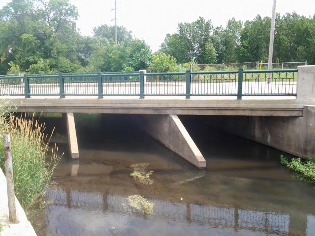
21 District 1 Silver Creek Culvert 5648 Crosses Silver Creek MN 61- Parallel to Lake Superior from Duluth up to Canadian Border AADT: 5,900 Detour Length: 24 miles


22 Existing Facility


23 Existing Hydrology Drainage Area: mi 2 Precipitation and Discharge: 24-hour Storm Event Return Period 2-yr storm 5-yr storm 10-yr storm 25-yr storm 50-yr storm 100-yr storm 500-yr storm (in) (in) (in) (in) (in) (in) (in) hour Storm Event Return Period 2-yr storm 5-yr storm 10-yr storm 25-yr storm 50-yr storm 100-yr storm 500-yr storm (cfs) (cfs) (cfs) (cfs) (cfs) (cfs) (cfs)
24 Performance of Existing Facility Currently system is functioning well when compared to design storm conditions Does not overtop at the current 50-year storm Performance decreases under future climate projections
25 Projected Climate Conditions 24-Hr Storm Return Period Atlas 14 Precip. Depth (in) Low Scenario Precipitation Depth (in) Medium Scenario Precipitation Depth (in) High Scenario Precipitation Depth (in) yr storm yr storm yr storm yr storm yr storm yr storm yr storm Data from SimCLIM
26 Projected Hydrologic Conditions 24-Hr Storm Return Period Existing Discharges (cfs) Low Scenario Discharges (cfs) Medium Scenario Discharges (cfs) High Scenario Discharges (cfs) yr storm 770 1,120 1,230 1,550 5-yr storm 1,350 1,830 2,000 2, yr storm 1,880 2,450 2,660 3, yr storm 2,690 3,390 3,670 4, yr storm 3,370 4,170 4,500 5, yr storm 4,140 5,000 5,420 6, yr storm 6,090 7,150 7,800 9,630
27 Base: Replace in-kind Adaptation Options Construct cost: $710,000 Option 1: Increase culvert to 16 X 14 Construction cost: $770,000 Option 2: Replace Culvert with a 35 span bridge Construction cost: $1,130,000 Option 3: Replace Culvert with a 40 span bridge Construction cost: $1,210,000
28 Benefit-Cost Assumptions Analysis period: Discount rate: 2.0% Safety Cost: $80,000 Detour Cost Per Day: Car Truck Total Operating Costs $40,176 $11,520 $51,696 Travel Time $78,624 $9,555 $88,179 Total $118,800 $21,075 $139,875
29 For Each Adaptation Option $3,000,000 Adaptation Option 1 Depth Damage Function $2,500,000 $2,000,000 $1,500,000 $1,000,000 $500,000 Embankment erosion starts $ Depth With Social Costs Without Social Costs Overtopping starts
30 For Each Adaptation Option for 3 time periods Adaptation Option 1: Depth Probabilities ( ) Depth % 1.0% 10.0% 100.0% Low Scenario Medium Scenario High Scenario
31 Depth Depth Option 1 Depth Probabilities ( ) % 1.0% 10.0% 100.0% % 1.0% 10.0% 100.0% Depth % 1.0% 10.0% 100.0% COAST Model $3,000,000 $2,500,000 $2,000,000 $1,500,000 $1,000,000 $500,000 Option 1 Depth Damage Function $ Depth With Social Costs Without Social Costs Low Scenario Medium Scenario High Scenario Construction Cost
32 Cost Effectiveness: Silver Creak Without Social Costs With Social Costs $1,400,000 $1,400,000 Cumulative Cost (Present Value) $1,200,000 $1,000,000 $800,000 $600,000 $400,000 $200,000 $1,200,000 $1,000,000 $800,000 $600,000 $400,000 $200,000 $0 Base case Option 1 Option 2 Option 3 $0 Base case Option 1 Option 2 Option 3 Low Med High Low Med High

33 Adaptation Analysis Case Study 2

34 District 6 Spring Valley Creek Culvert 5722 Crosses Spring Valley Creek US 63 connects Rochester to Cedar Rapids AADT 5,700 Detour: 0.6 miles

35 Existing Facility


36 Existing Hydrology Drainage Area: mi 2 Precipitation and Discharge: 24-hour Storm Event Return Period 2-yr storm 5-yr storm 10-yr storm 25-yr storm 50-yr storm 100-yr storm 500-yr storm (in) (in) (in) (in) (in) (in) (in) hour Storm Event Return Period 2-yr storm 5-yr storm 10-yr storm 25-yr storm 50-yr storm 100-yr storm 500-yr storm (cfs) (cfs) (cfs) (cfs) (cfs) (cfs) (cfs)
37 Performance of Existing Facility Currently Overtopped by 10-year Storm Prone to nuisance flooding due to Undersized conveyance area of culverts Low lying roadway profile Performance decreases under all future climate projections
38 Projected Climate Conditions 24-Hr Storm Return Period Atlas 14 Precip. Depth (in) Low Scenario Precipitation Depth (in) Medium Scenario Precipitation Depth (in) High Scenario Precipitation Depth (in) yr storm yr storm yr storm yr storm yr storm yr storm yr storm
39 Projected Hydrologic Conditions 24-Hr Storm Return Period Existing Discharge (cfs) Low Scenario Discharges (cfs) Medium Scenario Discharges (cfs) High Scenario Discharges (cfs) yr storm yr storm yr storm yr storm yr storm yr storm 500-yr storm
40 Adaptation Options Base: Replace in-kind Construct cost: $460,000 Option 1: Add 2 6 x10 culvert cells to existing design Construction cost: $690,000 Option 2: same as option 1 + floodplain enhancement Construction cost: $1,130,000 Option 3: Replace Culvert three span 84-foot long bridge Construction cost: $4,210,000
41 Cost Effectiveness: Spring Valley Without Social Costs With Social Costs 4,000,000 $4,000,000 Cumulative Cost (Present Value) 3,500,000 3,000,000 2,500,000 2,000,000 1,500,000 1,000, ,000 $3,500,000 $3,000,000 $2,500,000 $2,000,000 $1,500,000 $1,000,000 $500,000 0 Base case Option 1 Option 2 Option 3 $0 Base case Option 1 Option 2 Option 3 Low Med High Low Med High


42 Conceptual Adaptation Screening Framework
43 Assets currently performing poorly compared to design storm with high social costs (AADT > 10,000 and/or detour > 20 mi) Bridges 31 Culverts 6 Pipes 129 Road Segments 2
44 Assets currently performing poorly compared to design storm with high social costs (AADT > 10,000 and/or detour > 20 mi) Bridges 34 Culverts 21 Pipes 20
45 Next Steps Complete assessments in other districts and/or other types of assets (i.e. slopes) Support efforts to improve downscaling techniques and availability Incorporate considerations of risk into ongoing culvert and bridge improvement programs Incorporate scores into asset management databases and the asset management plan
46 QUESTIONS? Project Contact: Philip Schaffner Policy Planning Director MnDOT Office of Transportation System Management
MnDOT Flash Flood Vulnerability and Adaptation Assessment Pilot Project DISTRICT 1 SILVER CREEK CASE STUDY
 MnDOT Flash Flood Vulnerability and Adaptation Assessment Pilot Project DISTRICT 1 SILVER CREEK CASE STUDY NOVEMBER 2014 This document is part of a series of short reports based on the full Flash Flood
Adaptation to Extreme Weather Events and Climate Change
 Office of Planning, Environment and Realty Office of Infrastructure Adaptation to Extreme Weather Events and Climate Change SASHTO Meeting Robert Kafalenos, FHWA August 25, 2014 1 Planning for the Future
Gwinnett County Stormwater System Assessment Program
 Gwinnett County Stormwater System Assessment Program Jonathan Semerjian, PE Dept. of Water Resources Stormwater Management Sam Fleming, PE Dewberry Presentation Overview Project Background Drivers Enhanced
King County Flood Control District approves grants for flood prevention projects Regional projects to benefit from district funds
 News Release Contact: Al Sanders 206-477-1016 August 31, 2015 Flood Control District approves grants for flood prevention projects Regional projects to benefit from district funds The Flood Control District
Office of Strategic Planning and Projects Connecticut Department of Transportation CLIMATE CHANGE & EXTREME WEATHER PILOT PROJECT
 Office of Strategic Planning and Projects Connecticut Department of Transportation CLIMATE CHANGE & EXTREME WEATHER PILOT PROJECT LITCHFIELD HILLS Lake Waramaug, Warren/Kent/Washington LITCHFIELD HILLS
(1) Bridge, Road and Railway (Adaptation Project) (2) Bridge, Road and Railway (BAU Development with Adaptation Options)
 Bridge, Road and Railway (Adaptation Project) (2) Bridge, Road and Railway (BAU Development with Adaptation Options)") Sub-sector Guideline: (1) Bridge, Road and Railway (Adaptation Project) (2) Bridge, Road and Railway (BAU Development with Adaptation Options) Basic Concept A. General Concept Climate change will increase
Sub-sector Guideline: (1) Bridge, Road and Railway (Adaptation Project) (2) Bridge, Road and Railway (BAU Development with Adaptation Options) Basic Concept A. General Concept Climate change will increase
Flood Hazard Assessment Report Falls Gulch, Larimer County, Colorado January 16, 2013
 United States Department of Agriculture Natural Resources Conservation Service Denver Federal Center Building 56, Room 2604 P.O. Box 25426 Denver, CO 80225 720-544-2818-OFFICE alton.albin@co.usda.gov Flood
Chapter 7. Street Drainage. 7.0 Introduction. 7.1 Function of Streets in the Drainage System. 7.2 Street Classification
 7. Introduction This chapter summarizes methods to evaluate runoff conveyance in various street cross sections and curb types in the Town of Castle Rock and identifies acceptable upper limits of street
HYDROLOGIC & HYDRAULIC ASPECTS of the Walnut Street Bridge over the Schuylkill River Philadelphia, PA
 HYDROLOGIC & HYDRAULIC ASPECTS of the Walnut Street Bridge over the Schuylkill River Philadelphia, PA J. Richard Weggel CAEE201 Lectures 30 April & 2 May 2007 HYDROLOGY (Natural Science) Study of the waters
Impact of Sea Level Rise on Roadway Design. Paul Carroll, PE
 Impact of Sea Level Rise on Roadway Design Paul Carroll, PE September 14, 2016 State of Maryland Action Executive Order by Gov. O Malley established the Maryland Commission on Climate Change (MCCC) - 2007
Preparing Stormwater Systems for Climate Change October 10 th, 2013 Monroe, MI. Leslie Yetka, Education Manager
 Preparing Stormwater Systems for Climate Change October 10 th, 2013 Monroe, MI Leslie Yetka, Education Manager lyetka@minnehahacreek.org National Climate Assessment Report 2013 Duluth, MN June, 2012 Rainfall:
NRCS Hydrology methodology review Minnesota NRCS recommendation MnDOT recommendation Using Atlas 14 with HydroCAD
 Dec, 2015 NRCS Hydrology methodology review Minnesota NRCS recommendation MnDOT recommendation Using Atlas 14 with HydroCAD NRCS - Natural Resource Conservation Service (formerly known as SCS Soil Conservation
COON CREEK WATERSHED DISTRICT PERMIT REVIEW. Spring Lake Park Schools Westwood Middle School st Avenue NE, Spring Lake Park, MN 55432
 PAN 16-112, Westwood Middle School, Page 1 of 6 COON CREEK WATERSHED DISTRICT PERMIT REVIEW MEETING DATE: August 22, 2016 AGENDA NUMBER: 10 FILE NUMBER: 16-112 ITEM: Westwood Middle School RECOMMENDATION:
INFLOW DESIGN FLOOD CONTROL SYSTEM PLAN 40 C.F.R. PART PLANT YATES ASH POND B (AP-B ) GEORGIA POWER COMPANY
 GEORGIA POWER COMPANY") INFLOW DESIGN FLOOD CONTROL SYSTEM PLAN 40 C.F.R. PART 257.82 PLANT YATES ASH POND B (AP-B ) GEORGIA POWER COMPANY EPA s Disposal of Coal Combustion Residuals from Electric Utilities Final Rule (40 C.F.R.
INFLOW DESIGN FLOOD CONTROL SYSTEM PLAN 40 C.F.R. PART 257.82 PLANT YATES ASH POND B (AP-B ) GEORGIA POWER COMPANY EPA s Disposal of Coal Combustion Residuals from Electric Utilities Final Rule (40 C.F.R.
City of Katy Flood Protection Study (Meeting 3 of 3) October 23, 2017
 October 23, 2017") City of Katy Flood Protection Study (Meeting 3 of 3) October 23, 2017 Phasing of Meetings April Meeting May Meeting October Review of Tax Day Storm Event and Immediate Actions Taken By City Review of Coordination
City of Katy Flood Protection Study (Meeting 3 of 3) October 23, 2017 Phasing of Meetings April Meeting May Meeting October Review of Tax Day Storm Event and Immediate Actions Taken By City Review of Coordination
Project Drainage Report
 Design Manual Chapter 2 - Stormwater 2A - General Information 2A-4 Project Drainage Report A. Purpose The purpose of the project drainage report is to identify and propose specific solutions to stormwater
New Castle County, DE. Floodplain Regulations
 New Castle County, DE Floodplain Regulations John J. Gysling, PE CFM Department of Land Use New Castle County, DE February 26, 2009 Today s Presentation Floodplain Protection and Uses Terms and Definitions
Chapter 6 Hydrology TABLE OF CONTENTS CHAPTER 6 - HYDROLOGY
 Chapter 6 Hydrology TABLE OF CONTENTS CHAPTER 6 - HYDROLOGY... 6-1 6.1 Introduction... 6-1 6.1.1 Objective... 6-1 6.1.2 Definition... 6-1 6.1.3 Factors Affecting Floods... 6-1 6.1.4 Sources of Information...
Chapter 11 Culverts and Bridges
 Chapter 11 Culverts and Bridges Contents 1.0 Introduction... 1 2.0 General Design... 1 2.1 Design Criteria... 1 2.2 Design Flows... 1 2.3 Permitting and Regulations... 1 2.4 Aesthetics and Safety... 2
HYDROLOGIC CONSIDERATIONS. 22 nd Annual Nonpoint Source Pollution Conference Saratoga Springs, NY
 LOW IMPACT DEVELOPMENT HYDROLOGIC CONSIDERATIONS 22 nd Annual Nonpoint Source Pollution Conference Saratoga Springs, NY May 18, 2011 PRESENTATION AGENDA Introduction Definitions Discuss Impacts to Hydrologic
Chapter 6. Hydrology. 6.0 Introduction. 6.1 Design Rainfall
 6.0 Introduction This chapter summarizes methodology for determining rainfall and runoff information for the design of stormwater management facilities in the City. The methodology is based on the procedures
World Bank Study: Making Transport Climate Resilient
 World Bank Study: Making Transport Climate Resilient Adapting the road sector to climate change Presented by: Fang Xu, Economist, Africa Region Office, fxu@worldbank.org Karsten Sten Pedersen, Project
HYDROLOGY REPORT HEACOCK & CACTUS CHANNELS MORENO VALLEY, CALIFORNIA NOVEMBER 2005 REVISED APRIL 2006 REVISED AUGUST 2006
 HYDROLOGY REPORT HEACOCK & CACTUS CHANNELS MORENO VALLEY, CALIFORNIA NOVEMBER 2005 REVISED APRIL 2006 REVISED AUGUST 2006 RIVERSIDE COUNTY FLOOD CONTROL AND WATER CONSERVATION DISTRICT TABLE OF CONTENTS
Prepared for Urban Drainage and Flood Control District
 BERM FAILURE TECHNICAL ANALYSES SOUTH PLATTE GRAVEL PIT EVALUATION CRITERIA Prepared for Urban Drainage and Flood Control District Wright Water Engineers, Inc. January 2013 121-030.000 TABLE OF CONTENTS
INFLOW DESIGN FLOOD CONTROL SYSTEM PLAN 40 C.F.R. PART PLANT YATES ASH POND 3 (AP-3) GEORGIA POWER COMPANY
 GEORGIA POWER COMPANY") INFLOW DESIGN FLOOD CONTROL SYSTEM PLAN 40 C.F.R. PART 257.82 PLANT YATES ASH POND 3 (AP-3) GEORGIA POWER COMPANY EPA s Disposal of Coal Combustion Residuals from Electric Utilities Final Rule (40 C.F.R.
INFLOW DESIGN FLOOD CONTROL SYSTEM PLAN 40 C.F.R. PART 257.82 PLANT YATES ASH POND 3 (AP-3) GEORGIA POWER COMPANY EPA s Disposal of Coal Combustion Residuals from Electric Utilities Final Rule (40 C.F.R.
Project Goals and Scoping
 Prepared for: Boulder County, Colorado Flood Planning & Preliminary Design Services for South St. Vrain Creek Restoration at Hall Ranch and Scoping May 24, 2016 Meeting with General Public In association
Click to edit title style
 Click to edit title style Samuel B. Merrill, PhD Judy Gates November 16, 2015 Click to edit Master text styles Second level Third level Fourth level» Fifth level Integrating Storm Surge and Sea Level Rise
Culvert Sizing procedures for the 100-Year Peak Flow
 CULVERT SIZING PROCEDURES FOR THE 100-YEAR PEAK FLOW 343 APPENDIX A: Culvert Sizing procedures for the 100-Year Peak Flow A. INTRODUCTION Several methods have been developed for estimating the peak flood
ADAPTATION SYMPOSIUM Nicole Legault Environmental Policy Directorate Transport Canada
 ADAPTATION SYMPOSIUM 2016 Nicole Legault Environmental Policy Directorate Transport Canada April 13, 2016 PURPOSE Explore key risks and opportunities for the transportation sector from a changing climate
Municipal Stormwater Ordinances Summary Table
 APPENDIX F Municipal Ordinances Summary Table Municipality Abington Bryn Athyn Borough Hatboro Borough Ordinance, SALDO Runoff equals pre post Erosion Sediment Control Water Quality Requirements Any which
Stormwater Local Design Manual For Houston County, Georgia
 Stormwater Local Design Manual For Houston County, Georgia Adopted November 15, 2005 TABLE OF CONTENTS 1. FORWARD... 1 2. GENERAL LEVEL OF SERVICE STANDARDS... 2 2.1. DETENTION REQUIREMENTS... 2 2.1.1.
June 22, Francis E. Borcalli, P.E.
 CACHE CREEK SETTLING BASIN SYMPOSIUM Managing the Settling Basin Who s Doing What! June 22, 2009 Francis E. Borcalli, P.E. CACHE CREEK SETTLING BASIN SYMPOSIUM Managing the Settling Basin Who s Doing What!
III. INVENTORY OF EXISTING FACILITIES
 III. INVENTORY OF EXISTING FACILITIES Within the Growth Management Boundary, the existing storm drainage facilities are largely associated with development that has historically occurred in the ten drainage
S.R. 4031, SECTION FVR OVER BEAVER RUN SEGMENT 0170, OFFSET 6093 EAST NANTMEAL TOWNSHIP, CHESTER CO. ENGINEERING DISTRICT 6-0
 S.R. 4031, SECTION FVR OVER BEAVER RUN SEGMENT 0170, OFFSET 6093 EAST NANTMEAL TOWNSHIP, CHESTER CO. ENGINEERING DISTRICT 6-0 HYDROLOGIC & HYDRAULIC STUDY REPORT OCTOBER 2007 Prepared For: Prepared By:
ROLES AND RESPONSIBILITIES Small Pond Approval. SWM MD-378 Pond Checklist Training 10/17/07. Exemptions EMBANKMENT HEIGHT. Height of Dam Weir Wall
 SWM MD-378 Pond Checklist Training 10/17/07 Ken Wolfe Warren Johnson USDA, NRCS Frederick, Maryland ROLES AND RESPONSIBILITIES Small Pond Approval MDE, WMA, Dam Safety Division Authority (COMAR 26.17.04.03)
Informational Meeting- July 21, Boxelder B-2/B-3 Watershed Planning Study
 Informational Meeting- July 21, 2015 Boxelder B-2/B-3 Watershed Planning Study Agenda Introductions Background & History Purpose & Need NRCS Watershed Planning Program Work Completed to Date Longer term
MODEL Stormwater Local Design Manual. City of Centerville
 MODEL Stormwater Local Design Manual City of Centerville Adopted December 6, 2005 TABLE OF CONTENTS 1. FORWARD... 1 2. GENERAL LEVEL OF SERVICE STANDARDS... 1 2.1. DETENTION REQUIREMENTS... 1 2.1.1. Discharge
Surprise in Plymouth as flood floods floodplain in flooding season, 28 Feb 2017 (taken from Twitter)
") Surprise in Plymouth as flood floods floodplain in flooding season, 28 Feb 2017 (taken from Twitter) Projecting Future Changes in Flooding Across New England: More Challenging than You Might Think Cameron
Surprise in Plymouth as flood floods floodplain in flooding season, 28 Feb 2017 (taken from Twitter) Projecting Future Changes in Flooding Across New England: More Challenging than You Might Think Cameron
Urban Hydrology Characteristics and their Influence on Urban Stream Restoration Technology. Presented by:
 Urban Hydrology Characteristics and their Influence on Urban Stream Restoration Technology Presented by: Michael Clar Ecosite, Inc. James Gracie Brightwater, Inc. BACKGROUND Many streams in urban areas
SW-74 SERENOVA PRESERVE SITES 2, 3, 4, 8 MITIGATION PLAN
 SW-74 SERENOVA PRESERVE SITES 2, 3, 4, 8 MITIGATION PLAN BACKGROUND INFORMATION Project SWIM? Aquatic Control? Exotic Control? Mitigation Bank? Type No No No No Mitigation Restoration and enhancement Type
Appendix D - Evaluation of Interim Solutions
 Appendix D - Evaluation of Interim Solutions D.1 Introduction The implementation of long-term improvements is projected to take 5 to 8 years. To reduce the number of years of flooding impacts, the partner
Post-Fire BAER Assessment Burned Area Emergency Response (BAER)
") November 2017 Post-Fire BAER Assessment Burned Area Emergency Response (BAER) Information Brief Diamond Creek Fire Values at Risk Matrix and Treatments CentralWashingtonFireRecovery.info EMERGENCY DETERMINATION
November 2017 Post-Fire BAER Assessment Burned Area Emergency Response (BAER) Information Brief Diamond Creek Fire Values at Risk Matrix and Treatments CentralWashingtonFireRecovery.info EMERGENCY DETERMINATION
Peak discharge computation
 Ia/P 4 Peak Dischage Method Graphical Peak Discharge Method This chapter presents the Graphical Peak Discharge method for computing peak discharge from rural and urban areas. The Graphical method was developed
FIRM NAME DESIGNER: CHECKER: DATE: FPID #: DESCRIPTION: COUNTY: DRAINAGE DESIGN CHECKLIST. Designers Initials. Checkers Initials.
 I. Drainage Report A. Executive Summary - Brief Overview of Project Drainage Design B. Project Description 1. Existing Conditions 2. Proposed Project Conditions 3. Project Justification Narrative - Basin
South St. Vrain / Hall Meadows Restoration Planning August 20, 2015
 South St. Vrain / Hall Meadows Restoration Planning August 20, 2015 Agenda Introductions Purpose & Goals of Meeting Planning Area Master Plan Restoration Planning: Cost Estimates, Grants, Scope, Timeline
Location Drainage Study
 Location Drainage Study PROJECT ROUTE: LIMITS: MUNICIPALITY/COUNTY: JOB NUMBER: IL 47 at Burlington Road 750ft NW to 750ft SE of IL 47(Burlington), & 1000ft S to 1000ft N of Burlington (IL47) Kane County
Climate Change/Extreme Weather Vulnerability and Risk Assessment for Transportation Infrastructure in Dallas and Tarrant Counties
 Climate Change/Extreme Weather Vulnerability and Risk Assessment for Transportation Infrastructure in Dallas and Tarrant Counties Yekang Ko (School of Urban and Public Affairs) With Arne Winguth & Jun
Lower San Joaquin River Feasibility Study PLAN FORMULATION ADDENDUM
 PLAN FORMULATION ADDENDUM Non-Structural Measure Descriptions Elevate Critical Infrastructure This measure would raise at-risk critical structures above the design inundation level. Elevation would be
Outcomes. Kelly Karll-SEMCOG Margaret Barondess - MDOT
 Eco-Logical: I-75 Corridor I-75 Conservation Transportation Action Planning in to Monroe Achieve County: Multiple Stormwater Environmental Considerations Outcomes Kelly Karll-SEMCOG Karll@semcog.org Margaret
Guidance for NEPA and SEPA Project-Level Climate Change Evaluations
 Guidance for NEPA and SEPA Project-Level Climate Change Evaluations Environmental Services Office November 2014 Update Introduction to the 2014 Version WSDOT s Environmental Services Office developed the
Pre-Treatment Bioretention Cells Bioswales IOWA STORMWATER MANAGEMENT MANUAL DECEMBER 16, 2015
 Pre-Treatment Bioretention Cells Bioswales IOWA STORMWATER MANAGEMENT MANUAL DECEMBER 16, 2015 Urban Runoff Background How we got here What Problem?? Provenance of the Problem Unified Sizing Criteria What
DRAINAGE PLAN OF NAU S EASTBURN EDUCATION AND GAMMAGE BUILDINGS FINAL PROPOSAL
 MAY 10, 2016 DRAINAGE PLAN OF NAU S EASTBURN EDUCATION AND GAMMAGE BUILDINGS FINAL PROPOSAL Connor Klein, Jiangnan Yi, Yuzhi Zhang, Yi Yang NORTHERN ARIZONA UNIVERSITY NAU Water Buffalo Engineering Table
CHAPTER 7. San Dieguito River Flooding Adaptation
 CHAPTER 7 San Dieguito River Flooding Adaptation This chapter includes a range of adaptation measures to address vulnerabilities from flooding along the San Dieguito River, including the river valley,
INFLOW DESIGN FLOOD CONTROL SYSTEM PLAN 40 C.F.R. PART PLANT BOWEN ASH POND 1 (AP-1) GEORGIA POWER COMPANY
 GEORGIA POWER COMPANY") INFLOW DESIGN FLOOD CONTROL SYSTEM PLAN 40 C.F.R. PART 257.82 PLANT BOWEN ASH POND 1 (AP-1) GEORGIA POWER COMPANY EPA s Disposal of Coal Combustion Residuals from Electric Utilities Final Rule (40 C.F.R.
INFLOW DESIGN FLOOD CONTROL SYSTEM PLAN 40 C.F.R. PART 257.82 PLANT BOWEN ASH POND 1 (AP-1) GEORGIA POWER COMPANY EPA s Disposal of Coal Combustion Residuals from Electric Utilities Final Rule (40 C.F.R.
Culvert Prioritization Model: Aiding Communities in the Selection of Priority Restoration Projects
 Culvert Prioritization Model: Aiding Communities in the Selection of Priority Restoration Projects SNHPC Meeting January 24, 2017 1 Undersized Culverts! Culvert Sizes (~7,500 VT culverts) 6,000 5,000 69%
Temporary Watercourse Crossing: Culverts
 Temporary Watercourse Crossing: Culverts DRAINAGE CONTROL TECHNIQUE Low Gradient Velocity Control Short Term Steep Gradient Channel Lining Medium-Long Term Outlet Control Soil Treatment Permanent Symbol
Stream Simulation in Very Low Gradient Channels
 University of Massachusetts - Amherst ScholarWorks@UMass Amherst International Conference on Engineering and Ecohydrology for Fish Passage International Conference on Engineering and Ecohydrology for Fish
Chapter 3 Dispersion BMPs
 Chapter 3 Dispersion BMPs 3.1 BMP L611 Concentrated Flow Dispersion 3.1.1 Purpose and Definition Dispersion of concentrated flows from driveways or other pavement through a vegetated pervious area attenuates
APPENDIX A HYDROLOGIC AND HYDRAULIC ANALYSIS
 APPENDIX A HYDROLOGIC AND HYDRAULIC ANALYSIS GENERAL The Hydrologic and Hydraulic information presented in this appendix is provided as a supplement to the Dallas Floodway Extension General Re-evaluation
SECTION 11: REGULATORY FLOODWAYS
 SECTION 11: REGULATORY FLOODWAYS Contents 11.1. The Floodway... 11-2 11.1.1. The floodway concept... 11-2 11.1.2. Floodway map... 11-2 11.1.3. Floodway permitting... 11-3 11.1.4. Changing the floodway...
IAFSM 2010 Annual Conference. City of Rockford Keith Creek Greenway Flood Mitigation Project
 IAFSM 2010 Annual Conference City of Rockford Keith Creek Greenway Flood Mitigation Project March 10, 2010 Introduction Problem Overview 1890 s Building of homes along Keith Creek 1920 s Home construction
Pennsylvania Stormwater Best Management Practices Manual. Chapter 3. Stormwater Management Principles and Recommended Control Guidelines
 Pennsylvania Stormwater Best Management Practices Manual Chapter 3 Stormwater Management Principles and Recommended Control Guidelines 363-0300-002 / December 30, 2006 Chapter 3 Stormwater Management Principles
LOCATION AND DESIGN DIVISION
 VIRGINIA DEPARTMENT OF TRANSPORTATION LOCATION AND DESIGN DIVISION INSTRUCTIONAL AND INFORMATIONAL MEMORANDUM GENERAL SUBJECT: CULVERT DESIGN SPECIFIC SUBJECT: COUNTERSINKING AND LOW FLOW CONSIDERATIONS
Freight Street Development Strategy
 Freight Street Development Strategy Appendix B: Naugatuck River Floodplain Analysis Freight Street Development Strategy DECEMBER 2017 Page B-1 1.0 NAUGATUCK RIVER FLOODPLAIN AT FREIGHT STREET 1.1 Watershed
RIPARIAN CORRIDOR STUDY FINAL CITY CREEK MANAGEMENT PLAN TABLE OF CONTENTS
 TABLE OF CONTENTS 1.0 INTRODUCTION... 1-1 Riparian Corridor Study and Management Plan Goals... 1-1 Study Area... 1-2 Importance and Functions of Riparian Corridors... 1-2 Habitat for Mammals, Birds, and
Mike Jastremski, CFM Watershed Conservation Director
 Planning for Flood Resilient and Fish Friendly Road-Stream Crossings in CT s Northwest Hills Mike Jastremski, CFM Watershed Conservation Director Presentation Outline Project area Climate threats Field
Highway Drainage 1- Storm Frequency and Runoff 1.1- Runoff Determination
 Highway Drainage Proper drainage is a very important consideration in design of a highway. Inadequate drainage facilities can lead to premature deterioration of the highway and the development of adverse
10.0 Storm Sewer Systems
 October 2003 Chapter 10.0, Storm Sewer Systems Page 1 10.0 Storm Sewer Systems 10.1 Introduction A storm sewer system consists of a system of inlets, pipes, manholes, junctions, cleanouts, outlets, and
Hydrologic Calibration:
 Hydrologic Calibration: UPDATE OF EFFECTIVE HYDROLOGY FOR MARYS CREEK October 2010 Agenda Background Hydrologic model Calibrated rainfall Hydrologic calibration 100 year discharges, Existing Conditions
DRAINAGE & DESIGN OF DRAINAGE SYSTEM
 Drainage on Highways DRAINAGE & DESIGN OF DRAINAGE SYSTEM P. R.D. Fernando Chartered Engineer B.Sc.(Hons), M.Eng. C.Eng., MIE(SL) Drainage Requirement of Highway Drainage System Introduction Drainage means
PRINCESS ANNE DISTRICT STORMWATER PROJECTS
 PRINCESS ANNE DISTRICT STORMWATER PROJECTS Topics o o o o o Sea Level Rise and the Southern Watersheds Ashville Park Sherwood Lakes Kingston Estates Drainage Operations & Maintenance in the Southern Watersheds
CHAPTER 3 Environmental Guidelines for WATERCOURSE CROSSINGS GOVERNMENT OF NEWFOUNDLAND AND LABRADOR DEPARTMENT OF ENVIRONMENT AND LABOUR
 GOVERNMENT OF NEWFOUNDLAND AND LABRADOR DEPARTMENT OF ENVIRONMENT AND LABOUR CHAPTER 3 Environmental Guidelines for WATERCOURSE CROSSINGS WATER RESOURCES MANAGEMENT DIVISION Water Investigations Section
CORBIN AND NORDHOFF IV. ENVIRONMENTAL IMPACT ANALYSIS ENV EIR F. HYDROLOGY
 F. HYDROLOGY ENVIRONMENTAL SETTING Project Site The Project Site is located at 19601 Nordhoff Street in the Chatsworth area of the City of Los Angeles, California, within the Chatsworth - Porter Ranch
CHAPTER 26. SAN RAMON VALLEY FIRE PROTECTION DISTRICT ANNEX
 CHAPTER 26. SAN RAMON VALLEY FIRE PROTECTION DISTRICT ANNEX 26.1 HAZARD MITIGATION PLAN POINT OF CONTACT Primary Point of Contact Mike Picard, Battalion Chief 1500 Bollinger Canyon Rd San Ramon, CA 94583
Local Flood Hazard Mitigation Program. A framework for hazard mitigation in the NYC West of Hudson Water Supply Watersheds
 Local Flood Hazard Mitigation Program A framework for hazard mitigation in the NYC West of Hudson Water Supply Watersheds Flood Hazard Mitigation Defined 2 2 Presentation Overview Why and how is the NYC
V. DRAINAGE IMPROVEMENTS
 V. DRAINAGE IMPROVEMENTS 5.1 Formulation of Drainage Improvements As indicated in Chapter 4, following the completion of the hydrologic analysis associated with future land use conditions, drainage improvements
PART 3 - STANDARDS FOR SEWERAGE FACILITIES DESIGN OF STORM SEWERS
 PART 3 - STANDARDS FOR SEWERAGE FACILITIES 3.3 - DESIGN OF STORM SEWERS 3.301 Design of Storm Sewers A. General Information B. Investigations and Surveys C. Special Projects 3.302 Design Criteria for Storm
Safety, And Quality Of Life Needs
 The Ivey Wellpad Demands Adams County Mitigation Measures Required To Protect Critical Urban Area Health, Safety, And Quality Of Life Needs Overview Health Safety Quality of Live Citizens Support For Mitigation
SECTION STORM DRAINAGE DESIGN, GRADING, AND WATER QUALITY TECHNICAL CRITERIA TABLE OF CONTENTS PAGE 402 STORM DRAINAGE DESIGN CRITERIA 400-1
 CITY OF THORNTON Standards and Specifications Revised: October 2012 SECTION 400 - STORM DRAINAGE DESIGN, GRADING, AND WATER QUALITY TECHNICAL CRITERIA TABLE OF CONTENTS PAGE 401 GENERAL PROVISIONS 400-1
Engineering Hydrology Class 3
 Engineering Hydrology Class 3 Topics and Goals: I.Develop s (estimate precipitation) II.Develop simple constant intensity design storm III.Develop SCS design storm Ocean s Why do we want to derive the?
Camp Creek: Tackling Erosion and Improving Water Quality in a Recreational Playground Mitchellville, Iowa
 Camp Creek: Tackling Erosion and Improving Water Quality in a Recreational Playground Mitchellville, Iowa Rachel Conrad, PE, CFM IAFSM March 10 th, 2016 Outline Project Background and Goals Modeling Results
Appendix B. Storm Drain System Data
 MENIFEE VALLEY CAMPUS MASTER PLAN FINAL EIR MT. SAN JACINTO COMMUNITY COLLEGE DISTRICT Appendix Appendix B. Storm Drain System Data June 2017 MENIFEE VALLEY CAMPUS MASTER PLAN FINAL EIR MT. SAN JACINTO
5th Street Bridge Replacement Project Yuba City, California Location Hydraulic Study Report Bridge No. 18C0012
 EA 03-0L2324 Yuba City, California Location Hydraulic Study Report Submitted to: Prepared by: November 2012 Table of Contents Executive Summary... iii Acronyms... v 1 General Description... 1 1.1 Project
Subject: Use of Plastic Pipe for Storm Sewer and Culverts on Trunk Highways
 Minnesota Department of Transportation Engineering Services Division Technical Memorandum No. 17-05-B-02 April 11, 2017 Technical Memorandum To: Electronic Distribution Recipients From: Nancy T. Daubenberger,
Resilient Water and Wastewater Systems
 Resilient Water and Wastewater Systems June 2017 Ryan Berni Deputy Mayor City of New Orleans Patrick Schultz Principal & General Manager, Resource Optimization Veolia New Orleans A challenging delta landscape
POLICY FOR NATURAL RESOURCE MANAGEMENT AREAS
 POLICY FOR NATURAL RESOURCE MANAGEMENT AREAS I. POLICY STATEMENT Auburn University's (the University's) "Policy for Natural Resource Management Areas" implements the Campus Master Plan Land Use Element
Fullerton Creek Channel (OCFCD Facility No. A03) from downstream Beach Blvd. including undercrossing to downstream I-5 Freeway.
 from downstream Beach Blvd. including undercrossing to downstream I-5 Freeway.") Fullerton Creek Channel (OCFCD Facility. A03) Lead Agency: Agency: Project Director: Address: Orange County, Public Works, Infrastructure Programs, Capital Programs Sam Ali 300 N. Flower Street Santa Ana
Fullerton Creek Channel (OCFCD Facility. A03) Lead Agency: Agency: Project Director: Address: Orange County, Public Works, Infrastructure Programs, Capital Programs Sam Ali 300 N. Flower Street Santa Ana
INFLOW DESIGN FLOOD CONTROL SYSTEM PLAN. Bremo Power Station CCR Surface Impoundment: North Ash Pond INFLOW DESIGN FLOOD
 INFLOW DESIGN FLOOD CONTROL SYSTEM PLAN INFLOW DESIGN FLOOD CONTROL SYSTEM PLAN Bremo Power Station CCR Surface Impoundment: North Ash Pond Submitted To: Bremo Power Station 1038 Bremo Bluff Road Bremo
Table 9-1. Weighting Factors
 9.0 PRIORITIZATION As shown in Section 8.0, the SMP identified 99 projects with a total estimated cost of over $550 million. The next task was to develop a method for prioritizing the projects so that
Sewer System Flood Reduction Measures in the Rockcliffe Area
 PW28.6 REPORT FOR ACTION Sewer System Flood Reduction Measures in the Rockcliffe Area Date: March 26, 2018 To: Public Works and Infrastructure Committee From: General Manager, Toronto Water Wards: Ward
Appendix B. Benefit-Cost Technical Memorandum
 Appendix B Benefit-Cost Technical Memorandum This Page Left Blank Intentionally MEMORANDUM TO: FROM: Michael Kalnbach MnDOT District 1 Project Manager Graham Johnson, PE DATE: September 2, 2014 RE: TH
REQUEST FOR QUALIFICATIONS FOR DAYTON VALLEY AREA DRAINAGE MASTER PLAN
 REQUEST FOR QUALIFICATIONS FOR DAYTON VALLEY AREA DRAINAGE MASTER PLAN Statement of Qualifications due Friday, November 3, 2017 at 12:00 PM (Pacific Time) To the Carson Water Subconservancy District Office
Climate Change: Impacts, Monitoring, and Solutions
 Climate Change: Impacts, Monitoring, and Solutions 1 Responding to Climate Change 1. Projections/Impacts 2. Adaptation and Resiliency 3. Monitoring 4. What about emissions? 2 Native trout and salmon are
Overview of NRCS (SCS) TR-20 By Dr. R.M. Ragan
 TR-20 By Dr. R.M. Ragan") Overview of NRCS (SCS) TR-20 By Dr. R.M. Ragan TR-20 is a computer program for the simulation of runoff occurring from a single storm event. The program develops flood hydrographs from runoff and routes
Overview of NRCS (SCS) TR-20 By Dr. R.M. Ragan TR-20 is a computer program for the simulation of runoff occurring from a single storm event. The program develops flood hydrographs from runoff and routes
Modeling a Complex Hydraulic Environment Using a 1-D Approach Supplemented with Simple 2-D Principles Manas Borah Ed Dickson June 5, 2014
 ASFPM 2014 Annual Conference Modeling a Complex Hydraulic Environment Using a 1-D Approach Supplemented with Simple 2-D Principles Manas Borah Ed Dickson June 5, 2014 Agenda Overview and Background Hydrology
New York State DOT Adaptation to Climate Change and Extreme Weather. Elisabeth Lennon New York State Department of Transportation
 New York State DOT Adaptation to Climate Change and Extreme Weather Elisabeth Lennon New York State Department of Transportation Union College, January 2014 New York State Transportation is A vast and
Climate Change Impacts on Joint Riverine and Coastal Flooding on Calleguas Creek in Ventura County, CA
 Climate Change Impacts on Joint Riverine and Coastal Flooding on Calleguas Creek in Ventura County, CA James Gregory, James Jackson (ESA) Lily Verdone (TNC) FMA, September 8, 2016 Project Overview Coastal