ECOSYSTEM SERVICE LOSS DUE TO SOIL EROSION IN THE WATERSHED OF BINH DIEN RESERVOIR, VIETNAM NGUYEN THI MY QUYNH Supervisor: Prof.
|
|
|
- Abner Mosley
- 5 years ago
- Views:
Transcription

1 ECOSYSTEM SERVICE LOSS DUE TO SOIL EROSION IN THE WATERSHED OF BINH DIEN RESERVOIR, VIETNAM NGUYEN THI MY QUYNH Supervisor: Prof. KUNIHIKO YOSHINO LOCATION OF BINH DIEN RESERVOIR


2 Importance of Binh Dien Reservoir 1. Electricity generation about 175 mil. kwh per year 2. Flood control in rainy season 3. Irrigated water supply for agriculture in dry season Increasing flow accumulation: 5.8 m/s -> 30m/s

3 Binh Dien Reservoir characteristics -Maximum water level: 85 m - Death water level: 53 m - Water capacity: m 3 - Dam: 87m high, and 335m long


4 The watershed of Binh Dien Reservoir Land cover in Binh Dien watershed
 Sedimentation in the reservoir http://www.maweb.")
5 Ecosystem service vs. soil erosion problem Category of ecosystem services Soil erosion Soil loss Net primary productivity (NPP) Sedimentation in the reservoir esis.aspx (Millennium Ecosystem Assessment Synthesis Report) 1. Soil conservation 2. Water resource 3. Primary production
6 The Watershed s Characteristics Map of Binh Dien watershed Area: 500 sq. km High and steep sloped topography Poor plant cover Bare land: 13% Poor forest: 42% High and intensive rainfall Average annual rainfall ( ): mm Total amount of rainfall in 4 months (Sep.- Dec.) = 2/3 of annual rainfall Highly vulnerable to soil erosion by water
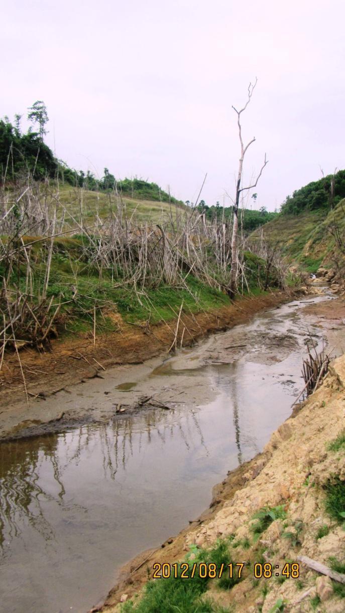
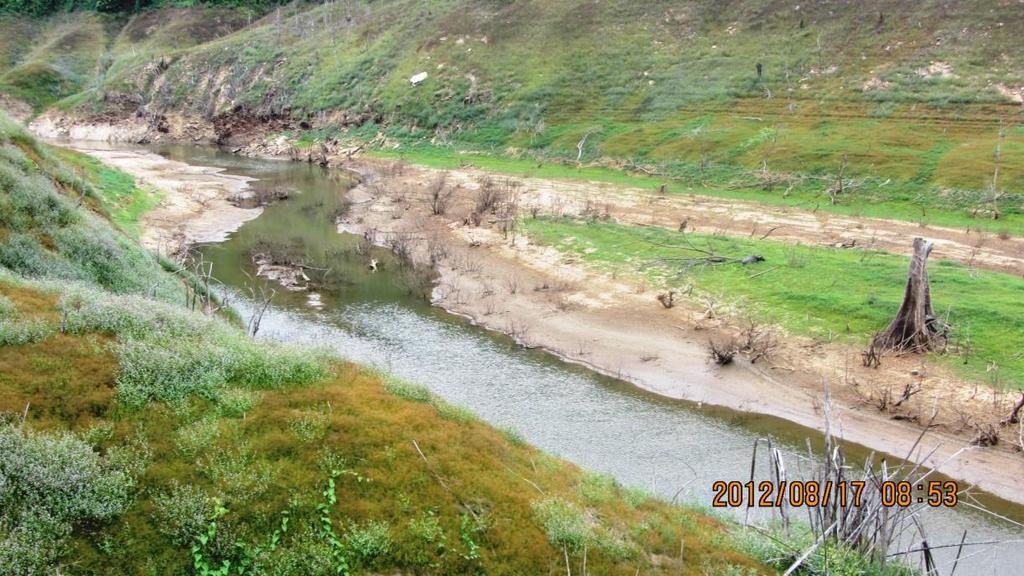

7 Sedimentation in the reservoir
8 Review 1. Soil erosion description Ho Kiet (1997): Soil erosion on head-watershed protection forest Ho Kiet (1999): soil loss rates on 7 cropping systems 2. Soil erosion prediction Ho Kiet (1996): Application of Wischmeier equation to predict soil erosion Ho Kiet (2002): calculating approximately R factor to predict soil erosion 3. Soil erosion mapping Pham Huu Ty (2008): soil erosion risk modeling Estimation of soil erosion impact on watershed ecosystem service has not been studied.
9 Objectives General objective To estimate ecosystem service loss due to soil erosion Specific objectives 1. To produce soil loss map based on RUSLE equation 2. To estimate impact of sedimentation on water capacity of the reservoir 3. To propose countermeasures for soil conservation in the watershed
10 Research Framework Primary production Soil loss Steeply sloped topography Siltation Sedimentation in reservoir Soil erosion by water Poor vegetation Water capacity Water quality Increase of sediment yield High and intensive rainfall Estimate soil loss rate using RUSLE equation Sediment yield Land use map Water capacity Counter -measure for soil conservati on
11 Methodology Monthly Rainfall Topography data Soil data Satellite images P factor = 1 Ho Kiet (1999) Ri = * Pi R factor Digital Elevation Model (DEM) Compute slope Compute flow accumulation LS factors Wischmeier soil erodibility nomograph K factor preprocessing TSAVI (Transformed Soil Adjusted Vegetation Index) C factor The RUSLE model: Soil loss rates (annual and seasonal) A = R * K * LS * C * P
12 Materials Factors Data Source C factor K factor Satellite images: -+ Landsat ETM, Landsat TM + ALOS AVNIR 2 Field survey data (August 2012) Land use map -Soil map: FAO name - Field survey: +At sampling site: soil texture +At laboratory: organic matter content JAXA + Department of Science and Technology in TTH province LS factor - Topographic map (scale 1/10,000) + Department of Natural Resource and Environment R factor - Monthly rainfall from 1980 to Meteorological stations: Binh Dien, Kim Long, A Luoi, and Thuong Nhat

13 R factor

14 Rainfall (mm) Annual rainfall (mm) R factor Average annual rainfall of stations from 1980 to Annual rainfall from 1980 to 2006 at four stations Binh Dien Average annual rainfall Kim Long A Luoi Thuong Nhat Stations Year

15 LS factor

16 K factor: Soil and organic matter content Sample Sample OC ID ID OC

17 C factor Nguyen Ngoc Lung, Vo Dai Hai (1997) Vegetation structure Natural forest with 3 layers, canopy cover: 0,7 0,8 Natural forest with 2 layers, canopy cover: 0,7 0,8 Grassland C factor 0,0070 0,0072 0,0076 0,0083 Bamboo forest Poor forest with 3 layers, canopy cover: 0,3 0,4 Pinus forest Recovered forest after shifting cultivation Mixed forest of Acacia and Cinnamomum Bareland with grass and shrub 0,0100 0,0108 0,0132 0,0134 0,0135 Mixed forest of Pinus and Acacia 0,0150 One layer forest, canopy cover 0,7 0,8 0,0186


18 C factor
19 Future work Finish mapping soil loss in the watershed Estimate sediment yield and its impact on water capacity of the reservoir Propose countermeasures to reduce soil loss rate
SOIL EROSION MODELING WORKSHOP ISPRA MARCH 2017
 SOIL EROSION MODELING WORKSHOP ISPRA 20 22 MARCH 2017 EROSION RATE PREDICTIONS FROM PESERA AND RUSLE AT A MEDITERRANEAN SITE BEFORE AND AFTER A WILDFIRE: COMPARISON, IMPLICATIONS AND ONGOING RESEARCH TOWARDS
Catastrophic flood events, climate change and land use management: a case study in the Thua Thien Hue Province, Viet Nam
 Adapting to Climate Change in Time Ancona, ACT Conference 2010 14.12.2010 Catastrophic flood events, climate change and land use management: a case study in the Thua Thien Hue Province, Viet Nam Fausto
Application of N-SPECT model and GIS for Soil erosion assessment in Sapa district, Lao Cai province
 VNU Journal of Science, Earth Sciences 27 (2011) 199-207 Application of N-SPECT model and GIS for Soil erosion assessment in Sapa district, Lao Cai province Nguyen Hieu*, Dang Kinh Bac, Dang Van Bao Faculty
[Suryawanshi 4(9): September 2017] ISSN DOI /zenodo Impact Factor
![[Suryawanshi 4(9): September 2017] ISSN DOI /zenodo Impact Factor](/thumbs/89/99073782.jpg "[Suryawanshi 4(9): September 2017] ISSN DOI /zenodo Impact Factor") GLOBAL JOURNAL OF ENGINEERING SCIENCE AND RESEARCHES ENVIRONMENTAL ASSESSMENT OF SOIL EROSION ON LAKNAVARAM LAKE BASIN Vijay Suryawanshi *1, D. Manaswini 2 and P.Pravalika 3 *1 Assistant Professor, KITS-Warangal,
GLOBAL JOURNAL OF ENGINEERING SCIENCE AND RESEARCHES ENVIRONMENTAL ASSESSMENT OF SOIL EROSION ON LAKNAVARAM LAKE BASIN Vijay Suryawanshi *1, D. Manaswini 2 and P.Pravalika 3 *1 Assistant Professor, KITS-Warangal,
Assessing the Current Condition of Damaged Ecosystem - Case Study for Umm Negga Site in the State of Kuwait
 Assessing the Current Condition of Damaged Ecosystem - Case Study for Umm Negga Site in the State of Kuwait Meshal Abdullah Rusty Feagin Steven Whisenant Layla Al Musawi Background Located in Asia continent
EFFECT OF FORESTS ON WATER REGULATION AND SOIL EROSION CONTROL
 Forests & Water/REF/16 EFFECT OF FORESTS ON WATER REGULATION AND SOIL EROSION CONTROL I. INTRODUCTION: Dr. Vo Dai Hai Deputy Director General Forest Science Institute of Vietnam Dong Ngac Tu Liem Hanoi/Vietnam
Tropical Agro-Ecosystem Function
 Tropical Agro-Ecosystem Function Soil erosion by water and wind Dr. Ronald F. Kühne; rkuehne@gwdg.de Georg-August-University Göttingen Department for Crop Sciences Tropical Agronomy Grisebachstr. 6, 37077
Multi-criteria decision analysis and GIS modeling for soil erosion vulnerability in the Toplica River Watershed
 University of Belgrade Faculty of Forestry Multi-criteria decision analysis and GIS modeling for soil erosion vulnerability in the Toplica River Watershed Tijana Vulevic, Nada Dragovic, Boris Radic University
Sediment dynamics response under global change:
 Sediment dynamics response under global change: Technical University of Madrid, UPM Catalan Institute for Water Research, ICRA Natural Capital Project, Stanford University 1 Soil erosion in southern Europe
Thanks to Bill Elliot, Research Leader U.S. Department of Agriculture Forest Service
 Thanks to Bill Elliot, Research Leader U.S. Department of Agriculture Forest Service To present an overview Forest Soil Erosion Processes 2 Precipitation or melting snow Evapotranspiration Infiltration
SOIL LOSS ESTIMATION USING GEOGRAPHIC INFORMATION SYSTEM IN ENFRAZ WATERSHED FOR SOIL CONSERVATION PLANNING IN HIGHLANDS OF ETHIOPIA
 ISSN: 2224-0616 Available online at http://www.ijarit.webs.com SOIL LOSS ESTIMATION USING GEOGRAPHIC INFORMATION SYSTEM IN ENFRAZ WATERSHED FOR SOIL CONSERVATION PLANNING IN HIGHLANDS OF ETHIOPIA Gizachew
Soil Loss Estimation on a Local Scale for Soil Conservation Planning
 JARQ 36 (3), 157 161 (2002) http://www.jircas.affrc.go.jp Soil Loss Estimation on a Local Scale for Soil Conservation Planning Soil Loss Estimation on a Local Scale for Soil Conservation Planning Takahiro
Determining C Factor of Universal Soil Loss Equation (USLE) Based on Remote Sensing
 Based on Remote Sensing") erd Research article Determining C Factor of Universal Soil Loss Equation (USLE) Based on Remote Sensing KUANG TING KUO Graduate School of Agriculture, Tokyo University of Agriculture, Tokyo, Japan Email:
erd Research article Determining C Factor of Universal Soil Loss Equation (USLE) Based on Remote Sensing KUANG TING KUO Graduate School of Agriculture, Tokyo University of Agriculture, Tokyo, Japan Email:
CATCHMENT AREA TREATMENT PLAN
 CATCHMENT AREA TREATMENT PLAN 1 NEED FOR CATCHMENT AREA TREATMENT It is a wellestablished fact that reservoirs formed by dams on rivers are subjected to sedimentation. The process of sedimentation embodies
Hands-on Session. Adrian L. Vogl Stanford University
 Hands-on Session Adrian L. Vogl Stanford University avogl@stanford.edu Questions InVEST can answer How much water is available? Where does the water used for hydropower production come from? How much energy
Vietnam- NCAP Study CLIMATE CHANGE IMPACTS IN HUONG RIVER BASIN AND ADAPTATION IN THUA THIEN HUE PROVINCE
 Vietnam- NCAP Study CLIMATE CHANGE IMPACTS IN HUONG RIVER BASIN AND ADAPTATION IN THUA THIEN HUE PROVINCE Project Expert Team IMHEN Prof. Dr. Tran Thuc, Project Director Mr. Le Nguyen Tuong, Project Coordinator
EROSION HAZARD MAPPING FOR MICRO-WATERSHED PRIORITIZATION USING REMOTE SENSING AND GIS TECHNIQUES
 EROSION HAZARD MAPPING FOR MICRO-WATERSHED PRIORITIZATION USING REMOTE SENSING AND GIS TECHNIQUES Dilip G. Durbude*, B. Venkatesh Hard Rock Regional Centre, National Institute of Hydrology, Hanuman Nagar,
WHERE WISDOM IS FREE. Dr. Ajai Singh Uttar Banga Krishi Viswavidyalaya West Bengal
 WHERE WISDOM IS FREE Dr. Ajai Singh Uttar Banga Krishi Viswavidyalaya West Bengal E-mail: ajai_jpo@yahoo.com Balanced ecosystems are essential for the survival and welfare of humankind. The ecosystems
MONITORING LAND COVER CHANGE IN THE UPPER PART OF DONG NAI RIVER BASIN, VIETNAM BY USING REMOTE SENSING AND GIS
 International Meeting on Land Cover and Emissions in South and Southeast Asia Ho Chi Minh City, 17 19 October 2016 MONITORING LAND COVER CHANGE IN THE UPPER PART OF DONG NAI RIVER BASIN, VIETNAM BY USING
STUDY ON SUITABILITY FOR NANG XUAN RICE VARIETY BY COMBINATION OF HANOI SOIL DATABASE AND CLIMATE CHANGE SCENARIO
 STUDY ON SUITABILITY FOR NANG XUAN RICE VARIETY BY COMBINATION OF HANOI SOIL DATABASE AND CLIMATE CHANGE SCENARIO Nguyen Xuan Hai, Vu Van Manh, Nguyen Thi Bich Nguyet, Pham Anh Hung, and Pham Thanh Van
Title Action Plan toward Effective Flood Hazard Mapping in My Country
 Title Action Plan toward Effective Flood Hazard Mapping in My Country JICA region focused training course on flood hazard mapping Sep 2006 LAI TUAN ANH Division of Geodesy Department of Planning and Management
SALINITY INTRUSION TREND IN RIVER AND CANAL SYSTEMS AND SOME PREVENTION METHODS IN BEN TRE PROVINCE
 Vietnam-Japan Estuary Workshop 2006 August 22 nd -24 th, Hanoi, Vietnam SALINITY INTRUSION TREND IN RIVER AND CANAL SYSTEMS AND SOME PREVENTION METHODS IN BEN TRE PROVINCE TRAN THI XUAN MY 1 AND NGUYEN
A Geographic Information System based Soil Loss Estimation in Lalen Watershed for Soil Conservation Planning, Highlands of Ethiopia
 Available online at http://www.journaldynamics.org/jdar Journal of Dynamics in Agricultural Research Vol. 2(3), pp.31-39, July 2015 Article ID: JDAR15/019 Author(s) retain the copyright of this article
Analyzing water resources in a monsoon-driven environment an example from the Indian Western Ghats
 Analyzing water resources in a monsoon-driven environment an example from the Indian Western Ghats 1, Shamita Kumar 2, Peter Fiener 1 and Karl Schneider 1 1,,, Germany 2 Institute of Environment Education
Use of GIS and Remote Sensing to assess Soil Erosion in Arid to Semiarid Basin in Jordan
 Use of GIS and Remote Sensing to assess Soil Erosion in Arid to Semiarid Basin in Jordan Ibrahim Farhan and Jawad Al Bakri Dept. Land, Water & Env. Faculty of Agriculture, University of Jordan, Amman,
FARMER PARTICIPATORY RESEARCH (FPR) ON SOIL EROSION CONTROL AND FERTILIZER USE FOR CASSAVA IN VIETNAM:
 ON SOIL EROSION CONTROL AND FERTILIZER USE FOR CASSAVA IN VIETNAM:") 352 FARMER PARTICIPATORY RESEARCH (FPR) ON SOIL EROSION CONTROL AND FERTILIZER USE FOR CASSAVA IN VIETNAM: 1999-2002 Nguyen The Dang 1 ABSTRACT In Vietnam, about 75% of the total land area are uplands,
352 FARMER PARTICIPATORY RESEARCH (FPR) ON SOIL EROSION CONTROL AND FERTILIZER USE FOR CASSAVA IN VIETNAM: 1999-2002 Nguyen The Dang 1 ABSTRACT In Vietnam, about 75% of the total land area are uplands,
AnnAGNPS. Annualized AGricultural Non-Point Source Pollurant Loading Model. Annualized Agricultural Non-Point Source Pollutant Loading Model
 AnnAGNPS Annualized AGricultural Non-Point Source Pollurant Loading Model 1 Erosion Erosion can be expresed as: E=f(C, S, T, SS, M) E = erosion C = climate S = soil properties T = topography SS = soil
Recommendations for Future Research to Support Erosion Hazard Assessment in Malawi
 Recommendations for Future Research to Support Erosion Hazard Assessment in Malawi 12 February, 1999 Flyson Bonda* John Mlava Martha Mughogho Kasweswe Mwafongo All four authors are part of the University
Land Characteristics and Soil Erosion in Relation to Slope Farming in the Highlands of Candikuning, Bali, Indonesia
 J. Jpn. Soc. Soil Phys. No. 21, p.-1./,**+ Land Characteristics and Soil Erosion in Relation to Slope Farming in the Highlands of Candikuning, Bali, Indonesia Hajime NARIOKA*, I.W. Sandi ADNYANA**, Mastur***
A STUDY ON QUANTITATIVE MONITORING OF SOIL LOSS IN SMALL WATERSHED BASED ON GIS
 A STUDY ON QUANTITATIVE MONITORING OF SOIL LOSS IN SMALL WATERSHED BASED ON GIS Liu Yaolin a,b a, b,, Luo Zhijun a School of Resource and Environment, Wuhan University, 129 Luoyu Road, Wuhan, China, 430079
Regional Seminar on SWAT, SANREM Book Launch and SWAT Workshop, Bogor, Indonesia (SWAT School of Bogor) June 27-29, 2012
 June 27-29, 2012") Regional Seminar on SWAT, SANREM Book Launch and SWAT Workshop, Bogor, Indonesia (SWAT School of Bogor) June 27-29, 2012 Introduction Objectives SWAT application Results Acknowledgements 2 Bi Doup - Núi
Regional Seminar on SWAT, SANREM Book Launch and SWAT Workshop, Bogor, Indonesia (SWAT School of Bogor) June 27-29, 2012 Introduction Objectives SWAT application Results Acknowledgements 2 Bi Doup - Núi
IJSRD - International Journal for Scientific Research & Development Vol. 3, Issue 03, 2015 ISSN (online):
:") IJSRD - International Journal for Scientific Research & Development Vol. 3, Issue 03, 2015 ISSN (online): 2321-0613 Estimation of Soil Erosion for Vishwamitri River Watershed Using Universal Soil Loss
IJSRD - International Journal for Scientific Research & Development Vol. 3, Issue 03, 2015 ISSN (online): 2321-0613 Estimation of Soil Erosion for Vishwamitri River Watershed Using Universal Soil Loss
Soil Erosion in Mauritius
 Soil Erosion in Mauritius & its mitigation by sugar cane cultivation By Suman Seeruttun & Daniel Ah Koon 5 December 2006 - Introduction - Soil erosion - processes & Universal Soil Loss Equation - Project
GIS MODELLING OF LAND DEGRADATION IN NORTHERN-JORDAN USING LANDSAT IMAGERY
 GIS MODELLING OF LAND DEGRADATION IN NORTHERN-JORDAN USING LANDSAT IMAGERY S. Essa a a Geology Department, Faculty of Science, UAE University, Al-Ain, UAE salem.essa@uaeu.ac.ae KEY WORDS: Remote Sensing,
Precipitation Surface Cover Topography Soil Properties
 Precipitation Surface Cover Topography Soil Properties Intrinsic capacity of rainfall to cause erosion Influenced by Amount, intensity, terminal velocity, drop size and drop size distribution of rain.
Application of SWAT Model in land-use. change in the Nile River Basin: A Review
 Application of SWAT Model in land-use change in the Nile River Basin: A Review By: Marwa Ali, Okke Batelaan and Willy Bauwens 15-6-2011 Application of SWAT Model in land-use 1 change in the Nile River
Application Of GIS Software For Erosion Control In The Watershed Scale
 Application Of GIS Software For Erosion Control In The Watershed Scale C. Setyawan, C. Y. Lee, M. Prawitasari Abstract: Land degradation in form of soil erosion due to uncontrolled farming is occurred
Internet GIS, Based on USLE Modeling, for Assessment of Soil Erosion in Songkhram Watershed, Northeastern of Thailand
 Kasetsart J. (Nat. Sci.) 46 : 272-282 (2012) Internet GIS, Based on USLE Modeling, for Assessment of Soil Erosion in Songkhram Watershed, Northeastern of Thailand Supakij Nontananandh 1 and Burin Changnoi
SOLUTIONS FOR SUSTAINABLE WATER USE AND MANAGEMENT IN DA NANG CITY
 MINISTRY OF NATURAL RESOURCES AND ENVIRONMENT DEPARTMENT OF WATER RESOURCES MANAGEMENT SOLUTIONS FOR SUSTAINABLE WATER USE AND MANAGEMENT IN DA NANG CITY September 2018 DR. NGUYEN MINH KHUYEN DEPUTY DIRECTOR
Estimation of Erosion Hazard Level Using Universal Soil Loss Equation (USLE) Method in Endanga Watershed, Southeast Sulawesi, Indonesia
 Method in Endanga Watershed, Southeast Sulawesi, Indonesia") AENSI Journals Advances in Environmental Biology ISSN-1995-0756 EISSN-1998-1066 Journal home page: http://www.aensiweb.com/aeb/ Estimation of Erosion Hazard Level Using Universal Soil Loss Equation (USLE)
AENSI Journals Advances in Environmental Biology ISSN-1995-0756 EISSN-1998-1066 Journal home page: http://www.aensiweb.com/aeb/ Estimation of Erosion Hazard Level Using Universal Soil Loss Equation (USLE)
Keywords, Water resources potential, runoff coefficient, event base, and seasonal analysis
 Calibration of Run-off Coefficients considering different rainfall and run-off events and seasonal flows (Case study for Laelay Wukro and GumSelassa watersheds) Mohammed A. Abdurahman a,b,d, Rainer Mohn
Isfahan University of Technology. Soil erosion hazard prediction by SWAT model and fuzzy logic in a highly mountainous watershed
 Isfahan University of Technology Soil erosion hazard prediction by SWAT model and fuzzy logic in a highly mountainous watershed Introduction Challenges Soil erosion A major environmental threat to the
Prediction of Soil Loss using SLEMSA and USLE Erosion Models for an Agricultural Field in Makurdi, Benue State, Nigeria
 International Journal of Innovative Agriculture & Biology Research 6(3):21-30, July-Sept., 2018 - SEAHI PUBLICATIONS, 2018 www.seahipaj.org ISSN: 235-293 Prediction of Soil Loss using SLEMSA and USLE Erosion
Regional Seminar on SWAT, SANREM Book Launch and SWAT Workshop, Bogor, Indonesia (SWAT School of Bogor) June 27-29, 2012
 June 27-29, 2012") Regional Seminar on SWAT, SANREM Book Launch and SWAT Workshop, Bogor, Indonesia (SWAT School of Bogor) June 27-29, 2012 Content Introduction Watershed Description Methodology Results Conclusions 8/10/2012
Regional Seminar on SWAT, SANREM Book Launch and SWAT Workshop, Bogor, Indonesia (SWAT School of Bogor) June 27-29, 2012 Content Introduction Watershed Description Methodology Results Conclusions 8/10/2012
QUANTIFICATION OF SOIL EROSION BY WATER USING GIS AND REMOTE SENSING TECHNIQUES: A STUDY OF PANDAVAPURA TALUK, MANDYA DISTRICT, KARNATAKA, INDIA
 QUANTIFICATION OF SOIL EROSION BY WATER USING GIS AND REMOTE SENSING TECHNIQUES: A STUDY OF PANDAVAPURA TALUK, MANDYA DISTRICT, KARNATAKA, INDIA M. Vinay, Ramu and B. Mahalingam Center for Geoinformatics
Prioritizing Water-Quality Improvement Efforts on Agricultural Lands Using LiDAR Elevation Data
 Prioritizing Water-Quality Improvement Efforts on Agricultural Lands Using LiDAR Elevation Data Aaron Ruesch and Theresa Nelson Wisconsin Department of Natural Resources WLWCA March 11, 2014 Outline WLWCA
Soil Erosion map of Europe based on high resolution input datasets
 Soil Erosion map of Europe based on high resolution input datasets Panagos Panos 1, Pasqualle Borrelli 1, Katrin Meusburger 2, Cristiano Ballabio 1, Christine Alewell 2 1 European Commision Joint Research
Unit 9: Risk Assessment of Soil Erosion
 Unit 9: Risk Assessment of Soil Erosion H.P. Nachtnebel IWHW BOKU 1 Structure of presentation Objectives and background information Process analysis Analysis of loads Analysis of impacts Summary and conclusion
Modelling the impact of land use change on the water balance in the Xiangxi Catchment (Three Gorges Region, China) using SWAT
 using SWAT") Modelling the impact of land use change on the water balance in the Xiangxi Catchment (Three Gorges Region, China) using SWAT K. Bieger, B. Schmalz, Q. Cai, N. Fohrer 2010 International SWAT Conference
Modelling the impact of land use change on the water balance in the Xiangxi Catchment (Three Gorges Region, China) using SWAT K. Bieger, B. Schmalz, Q. Cai, N. Fohrer 2010 International SWAT Conference
Application of RUSLE Model on Global
 Annual Journal of Hydraulic Engineering, JSCE, VOL.45, 2001, February Application of RUSLE Model on Global Soil Erosion Estimate Thai Nam PHAM1, Dawen YANG2, Shinjiro KANAE3, Taikan OKI4, and Katumi MUSIAKE5
Geo-informatics for the Land capability of Khabaung Watershed Area by Using Stories Index Rating (SIR), Bago Region
, Bago Region") Hinthada University Research Journal 2016, Vol. 7, No. 1 158 Geo-informatics for the Land capability of Khabaung Watershed Area by Using Stories Index Rating (SIR), Bago Region Yu Yu Maw Abstract Soil
Hinthada University Research Journal 2016, Vol. 7, No. 1 158 Geo-informatics for the Land capability of Khabaung Watershed Area by Using Stories Index Rating (SIR), Bago Region Yu Yu Maw Abstract Soil
GIS Based Analysis of Biophysical and Socio - Economic Factors for Land Degradation in Kandaketiya DS Division
 Tropical Agricultural Research Vol. 21(4): 361-367 (2010) GIS Based Analysis of Biophysical and Socio - Economic Factors for Land Degradation in Kandaketiya DS Division K.D.B.L. Jayarathne, N.D.K. Dayawansa
Rainfall Analysis for Estimation of Peak Discharge and Soil Erosion on the Catchment Area of Musi Hydro-Power Plant, Bengkulu Indonesia
 2014 International Conference on Intelligent Agriculture IPCBEE vol.63 (2014 ) (2014 ) IACSIT Press, Singapore DOI: 10.7763/IPCBEE. 2014. V63. 14 Rainfall Analysis for Estimation of Peak Discharge and
Soil Erosion and Sediment Yield of a Sanitary Landfill Site A Case Study
 Soil Erosion and Sediment Yield of a Sanitary Landfill Site A Case Study Oon, Y.W. 1, Chin, N.J. 2 and Law, P.L. 3 Abstract - This research presents the results of a study on soil erosion rates and sediment
FARMER PARTICIPATORY RESEARCH (FPR) TRIALS ON CASSAVA INTERCROPPING SYSTEMS IN VIETNAM. Tran Thi Dung 1 and Nguyen Thi Sam 1
 TRIALS ON CASSAVA INTERCROPPING SYSTEMS IN VIETNAM. Tran Thi Dung 1 and Nguyen Thi Sam 1") 377 FARMER PARTICIPATORY RESEARCH (FPR) TRIALS ON CASSAVA INTERCROPPING SYSTEMS IN VIETNAM Tran Thi Dung 1 and Nguyen Thi Sam 1 ABSTRACT Farmers in Vietnam practiced intercropping before the FPR project.
377 FARMER PARTICIPATORY RESEARCH (FPR) TRIALS ON CASSAVA INTERCROPPING SYSTEMS IN VIETNAM Tran Thi Dung 1 and Nguyen Thi Sam 1 ABSTRACT Farmers in Vietnam practiced intercropping before the FPR project.
Status of Soil Resources in Lebanon
 Status of Soil Resources in Lebanon By Roger FRANCIS CNRS-National Center for Remote Sensing Jordan Amman 1-5 April 2012 Status of environment and coastal ecosystem State of the art on soil studies in
Estimation of Soil Erosion Based on USLE and GIS in Gardez Basin of Paktya Province, Afghanistan
 erd Estimation of Soil Erosion Based on USLE and GIS in Gardez Basin of Paktya Province, Afghanistan Research article ABDUL MALIK DAWLATZAI Graduate School of Agriculture, Tokyo University of Agriculture,
Analysis of Runoff Impact by Land Use Change Scenarios in an Urbanizing Watershed Using SWAT Model
 2012 SWAT International Conference Analysis of Runoff Impact by Land Use Change Scenarios in an Urbanizing Watershed Using SWAT Model July 20, 2012 YU, Young-Seok* Graduate Student KIM, Sang-Ho / LEE,
International Journal of Science and Research (IJSR) ISSN (Online): Impact Factor (2012): Kennedy. M. Kariuki 1, Felix. N.
 ISSN (Online): Impact Factor (2012): Kennedy. M. Kariuki 1, Felix. N.") Identifying the Impacts of Land Use-Land Cover Changes and Soil Erosion Risk on Water Quality and Watershed Health - A Case Study of River Enderit in Nakuru County, Kenya Kennedy. M. Kariuki 1, Felix.
Identifying the Impacts of Land Use-Land Cover Changes and Soil Erosion Risk on Water Quality and Watershed Health - A Case Study of River Enderit in Nakuru County, Kenya Kennedy. M. Kariuki 1, Felix.
Assessment of sediment and carbon flux in a tropical watershed: the Red River study case (China and Vietnam)
") Assessment of sediment and carbon flux in a tropical watershed: the Red River study case (China and Vietnam) Xi WEI Supervisors: Sabine SAUVAGE, Jose-Miguel SANCHEZ-PEREZ, Thi Phuong Quynh LE 2 th September
Assessment of sediment and carbon flux in a tropical watershed: the Red River study case (China and Vietnam) Xi WEI Supervisors: Sabine SAUVAGE, Jose-Miguel SANCHEZ-PEREZ, Thi Phuong Quynh LE 2 th September
A Case Study on a MRV System for REDD+ in Lao P.D.R.
 International Technical Seminar on REDD+, 16-17 February, 2011, Tokyo, Japan Session 5: R&D Trend about MRV Methods for REDD+ A Case Study on a MRV System for REDD+ in Lao P.D.R. Mitsuru NASU, Ph.D. *
Open Linked Data in Portugal
 Open Linked Data in Portugal Contribution for INSPIRE Implementation Maria José Vale, Rui Reis, Bruno M. Meneses, Raquel Saraiva, Paulo Patrício, Jesus Estrada Maria José Vale, Rui Reis, Bruno M. Meneses,
FPR TRIALS ON CASSAVA INTERCROPPING AND WEED CONTROL IN VIETNAM
 FPR TRIALS ON CASSAVA INTERCROPPING AND WEED CONTROL IN VIETNAM FARMER PARTICIPING RESEARCH IN VIETNAM FPR TRIALS: NEW VARIETIES FERTILIZERS SOIL EROSION INTERCROPPING WEED CONTROL N resource + residues
Recent Drought and Drought Prediction System Development in Korea
 IDI Introduction and Session Agenda Dr. Ali Chavoshian, IDI Secretariat, UNESCO/RCUWM-Tehran Recent Drought and Drought Prediction System Development in Korea Prof. Deg-Hyo, Bae, Sejong University, Seoul,
Assessment of Flood Hazard in Hanoi City
 VNU Journal of Earth and Environmental Sciences, Vol. 29, No. 1 (2013) 26-37 Assessment of Flood Hazard in Hanoi City Nguyễn Hiệu *, Đỗ Trung Hiếu, Đặng Kinh Bắc, Đoàn Thu Phương * Faculty of Geography,
LAND USE PLANNING FOR MAMMINASATA METROPOLITAN WATER AVAILABILITY, SOUTH SULAWESI, INDONESIA
 LAND USE PLANNING FOR MAMMINASATA METROPOLITAN WATER AVAILABILITY, SOUTH SULAWESI, INDONESIA Roland Alexander Barkey 1, Muh. Faisal M. 2 1 Research & Development Center for Natural Heritage, Biodiversity
Assessment of Soil Erosion using USLE Model in the Kandi Area of Punjab
 Assessment of Soil Erosion using USLE Model in the Kandi Area of Punjab Ismeet Singh Saluja ZHCET, AMU, Aligarh M.A. Alam PEC University of Technology ABSTRACT The Kandi Area lying in the Punjab state
Economic evaluation of Payments for Forest Ecosystem Services (PFES) programs in Vietnam
 programs in Vietnam") Economic evaluation of Payments for Forest Ecosystem Services (PFES) programs in Vietnam Tiho Ancev, Jacopo Giacomoni and Mara Thiene Environment, Sustainable Agriculture and Forest Management Conference
Economic evaluation of Payments for Forest Ecosystem Services (PFES) programs in Vietnam Tiho Ancev, Jacopo Giacomoni and Mara Thiene Environment, Sustainable Agriculture and Forest Management Conference
Water balance of savannah woodlands: a modelling study of the Sudanese gum belt region
 Department of Forest Sciences/ VITRI Faculty of Agriculture and Forestry Water balance of savannah woodlands: a modelling study of the Sudanese gum belt region Syed Ashraful Alam (Ashraful.Alam@helsinki.fi)
Land Use Change Effects on Discharge and Sediment Yield of Song Cau Catchment in Northern Vietnam
 NPUST 2010 INTERNATIONAL SWAT CONFERENCE August 4-6 th, 2010 MAYFIELD HOTEL, SEOUL, KOREA Land Use Change Effects on Discharge and Sediment Yield of Song Cau Catchment in Northern Vietnam Phan Dinh Binh
A Study of Himreen Reservoir Water Quality Using in Situ Measurement and Remote Sensing Techniques
 A Study of Himreen Reservoir Water Quality Using in Situ Measurement and Remote Sensing Techniques Dr. Salah A. H. Saleh College of Science, Nahrain University, Baghdad - IRAQ Abstract The use of remote
Using GIS to Estimate Soil Loss Rates in Denton County, Texas
 Using GIS to Estimate Soil Loss Rates in Denton County, Texas Bill Forbes, Laura Davenport, Bill Cruce, and Kenneth Yazel Advanced Geographic Information Systems Dr. Minhe Ji Spring 2001 Research Problem
Consequences of large hydropower dams on erosion budget within hilly agricultural catchments in Northern Vietnam by RUSLE modeling
 Consequences of large hydropower dams on erosion budget within hilly agricultural catchments in Northern Vietnam by RUSLE modeling Nguyen Van Thiet 1, Orange Didier 2, Laffly Dominique 3 and Pham Van Cu
National Forest Monitoring System Development in Cambodia
 National Forest Monitoring System Development in Cambodia 5 th UN-REDD Regional Lesson Learn Workshop Forest Monitoring System and Reference Levels for REDD+ Hanoi, Vietnam, 20-22 October, 2014 Presented
Assessment and mapping of GRASSLAND ecosystems condition and their services in Bulgaria, Contr. Д-33-90/
 1 General typology of grassland ecosystems We consider Grassland ecosystem as a natural or seminatural vegetation type. It could be part of farm holdings like pastures, meadows, uncultivated lands, etc.
Revised Universal Soil Loss Equation
 Revised Universal Soil Loss Equation April 2003 Sustainable Agriculture Resource Section AGDEX # 572/751 In April 2002, the Agricultural Crop Rotation Act (ACRA) was adopted to protect water and soil quality
Soil Erosion Is Influenced by Grain for Green Policy in Loess Plateau Area of Northern Shaanxi, China
 International Journal of Environmental Protection and Policy 2015; 3(5): 129-136 Published online September 2, 2015 (http://www.sciencepublishinggroup.com/j/ijepp) doi: 10.11648/j.ijepp.20150305.13 ISSN:
Rice crop monitoring using EO data in the Mekong Delta, Vietnam
 The 10th GEOSS Asia-Pacific Symposium WG5: Agriculture and Food Security Hanoi, 18-20 th, Sep. 2017 Rice crop monitoring using EO data in the Mekong Delta, Vietnam Lam Dao Nguyen, Hoang Phi Phung, Dang
M.L. Kavvas, Z. Q. Chen, M. Anderson, L. Liang, N. Ohara Hydrologic Research Laboratory, Civil and Environmental Engineering, UC Davis
 Assessment of the Restoration Activities on Water Balance and Water Quality at Last Chance Creek Watershed Using Watershed Environmental Hydrology (WEHY) Model M.L. Kavvas, Z. Q. Chen, M. Anderson, L.
GIS Analysis of Gully Head Erosion Rates on High Ridge Tree Farm in Winona County, Minnesota
 GIS Analysis of Gully Head Erosion Rates on High Ridge Tree Farm in Winona County, Minnesota Lisa M. Worrell Department of Resource Analysis, Saint Mary s University of Minnesota, Winona, MN 55987. Keywords:
1 Egyptian J. Desert Res., 65, No. 1, 1-10 (2015)
") 1 RUNOFF MANAGEMENT TECHNOLOGY FOR INTEGRATED DRY LAND AGRICULTURE IN JATINANGOR RESEARCH CENTER WEST JAVA, INDONESIA Nurpilihan Bafdal *, Sophia Dwiratna and Dwi R. Kendarto Soil and Water Engineering
1 RUNOFF MANAGEMENT TECHNOLOGY FOR INTEGRATED DRY LAND AGRICULTURE IN JATINANGOR RESEARCH CENTER WEST JAVA, INDONESIA Nurpilihan Bafdal *, Sophia Dwiratna and Dwi R. Kendarto Soil and Water Engineering
A Study on Estimation of the amount of Soil erosion in Small watershed Based on GIS: a case study in the Three Gorge Area of China
 A Study on Estimation of the amount of Soil erosion in Small watershed Based on GIS: a case study in the Three Gorge Area of China Liu Yaolin School of Resource and Environment Wuhan University Wuhan,
State of Agriculture in the Uplands of Southern Mindanao
 State of Agriculture in the Uplands of Southern Mindanao (focused in UDP covered barangays) Aurea Christie Galvez-Lumaad, Environment Coordinator Resource Management Component Upland Development Programme
ISSN: [Kamuju* et al., 5(10): October, 2016] Impact Factor: 4.116
![ISSN: [Kamuju* et al., 5(10): October, 2016] Impact Factor: 4.116](/thumbs/82/84976301.jpg "ISSN: [Kamuju* et al., 5(10): October, 2016] Impact Factor: 4.116") IJESRT INTERNATIONAL JOURNAL OF ENGINEERING SCIENCES & RESEARCH TECHNOLOGY SPATIAL IDENTIFICATION AND CLASSIFICATION OF SOIL EROSION PRONE ZONES USING REMOTE SENSING & GIS INTEGRATED RUSLE MODEL AND SATEEC
IJESRT INTERNATIONAL JOURNAL OF ENGINEERING SCIENCES & RESEARCH TECHNOLOGY SPATIAL IDENTIFICATION AND CLASSIFICATION OF SOIL EROSION PRONE ZONES USING REMOTE SENSING & GIS INTEGRATED RUSLE MODEL AND SATEEC
Environmental Assessment of the Rapid Expansion of Intensive Shrimp Farming in Tam Giang - Cau Hai Lagoon, Central Viet Nam
 駒澤地理 No.49 pp. 1 ~ 9, 2013 Komazawa Journal of Geography Environmental Assessment of the Rapid Expansion of Intensive Shrimp Farming in Tam Giang - Cau Hai Lagoon, Central Viet Nam Yukihiro HIRAI *, Tetsuo
Vietnam Baseline Perspective. Key issues and trends in the Mekong Delta
 Vietnam Baseline Perspective Key issues and trends in the Mekong Delta Structure of presentation National macro-economics - Total national GDP trend - Key growing sector - Drivers of the trend - Government
Long-term erosion measurements on sloping lands in northern Vietnam: impact of land use change on bed load output
 Long-term erosion measurements on sloping lands in northern Vietnam: impact of land use change on bed load output Didier Orange* 2, Pham Dinh Rinh* 1, Tran Duc Toan* 1, Thierry Henri des Tureaux 2, Mathieu
RESULTS FOR SEMESTER II THE ACADEMIC YEAR
 Class: Movers 1.1 1 TRAN TUE ANH 8,9 9,4 10,0 9,2 10,0 9,6 8,7 9,5 9,4 High Distinction 2 TRAN HOANG DUY BAO 9,9 10,0 10,0 9,4 10,0 9,8 8,7 8,5 9,5 High Distinction 3 PHAM DUY CUONG 8,6 9,6 10,0 9,1 10,0
Popular Kheti. Volume-2, Issue-3 (July-September), 2014 Available online at popularkheti.info ISSN:
, 2014 Available online at popularkheti.info ISSN:") Watershed Management- Solution to Water Crisis Rahul Chopra*, Ajeet Singh, Pravisha Lahoty and Manisha Rana Rajasthan College of Agriculture, MPUAT, Udaipur-313001 *Email of corresponding author: rahulrockingcool969@gmail.com
Watershed Management- Solution to Water Crisis Rahul Chopra*, Ajeet Singh, Pravisha Lahoty and Manisha Rana Rajasthan College of Agriculture, MPUAT, Udaipur-313001 *Email of corresponding author: rahulrockingcool969@gmail.com
Soil salinity and cotton yield estimation on regional scale in Tarim River Basin using EPIC Model and SOTER approach
 2 nd MEECAL conference: Management of Ecosystems and Environmental Changes in Arid Lands in Central Asia 10 th and 14 th December 2015, Munich, Germany Final Sino-German Conference of SuMaRiO Soil salinity
IMPACT OF LAND USE/COVER CHANGES ON STREAMFLOW:
 IMPACT OF LAND USE/COVER CHANGES ON STREAMFLOW: THE CASE OF HARE RIVER WATERSHED, ETHIOPIA Kassa Tadele and Gerd Foerch University of Siegen July 06, 2007 Presentation outline 1. Introduction Study area
FLOOD MANAGEMENT IN THE RED THAI BINH RIVER BASIN VIET NAM
 FLOOD MANAGEMENT IN THE RED THAI BINH RIVER BASIN VIET NAM By Dr. To Trung Nghia Director of Institute of Water Resources Planning Chief of the Red Thai Binh RBO Office E-mail: iwrp.hanoi@hn.vnn.vn INTRODUCTION
Ecological Site Descriptions and Hydrologic Assessment
 Ecological Site Descriptions and Hydrologic Assessment Frederick B. Pierson Research Leader and Rangeland Hydrologist USDA Agricultural Research Service Northwest Watershed Research Center, Boise, Idaho
FOREST COVER MAPPING AND GROWING STOCK ESTIMATION OF INDIA S FORESTS
 FOREST COVER MAPPING AND GROWING STOCK ESTIMATION OF INDIA S FORESTS GOFC-GOLD Workshop On Reducing Emissions from Deforestations 17-19 April 2007 in Santa Cruz, Bolivia Devendra PANDEY Forest Survey of
SPACE TECHNOLOGY FOR FLOOD WATER HARVESTING FOR IRRIGATION AND OTHER USES
 SPACE TECHNOLOGY FOR FLOOD WATER HARVESTING FOR IRRIGATION AND OTHER USES Integrated Flood Water Harvesting For Irrigation and Multipurpose Use for Community Resilience and Zero Emission in 3 Districts
Mission. Selected Accomplishments from Walnut Gulch. Facilities. To develop knowledge and technology to conserve water and soil in semi-arid lands
 USDA-ARS Southwest Watershed Research Center Mission Sound Science for Watershed Decisions To develop knowledge and technology to conserve water and soil in semi-arid lands ARS Watershed Locations Selected
Climate Change Impacts: Caribbean
 a work in progress Climate Change Impacts: watersheds of Mesoamerica and the Caribbean Water quality and availability Flood potential Context CATHALAC & SERVIR Climate Change and Biodiversity Increasing
Evaluation of Empirical and Nomograph Method of Predicting Erodibility Index for Selected Savannah Soils.
 Evaluation of Empirical and Nomograph Method of Predicting Erodibility Index for Selected Savannah Soils. A.I. Arab, M.Sc. 1* ; Prof. S.Z. Abubakar 1 ; and U.D. Idris, M.Sc. 2 1 National Agricultural Extension
Remote sensing methods in soil erosion assessment in the Mátra Mountains, Hungary
 ACTA Geographica Szegediensis Tomus XXXI. 1993. pp. 89-98. Remote sensing methods in soil erosion assessment in the Mátra Mountains, Hungary Dr. Gábor Mezõsi - Dr. Lás7ló Mucsi Abstract In the test site,
Soil erosion modelling in an agroforested catchment of NE Spain affected by gullying using SWAT
 Soil erosion modelling in an agroforested catchment of NE Spain affected by gullying using SWAT Mario Guevara Bonilla José Antonio Martínez Casasnovas María Concepción Ramos University of Lleida (Spain)