Assessing the Current Condition of Damaged Ecosystem - Case Study for Umm Negga Site in the State of Kuwait
|
|
|
- Jonathan Curtis
- 5 years ago
- Views:
Transcription


1 Assessing the Current Condition of Damaged Ecosystem - Case Study for Umm Negga Site in the State of Kuwait Meshal Abdullah Rusty Feagin Steven Whisenant Layla Al Musawi

2 Background Located in Asia continent Total area of 17,000 km 2 Desert climate Occasional rainfall

3 Background The world s largest hydrocarbon spill, and one of the worst environmental disasters in history, occurred as a result of Iraq s unlawful invasion and occupation of Kuwait in Multiple ecosystems in Kuwait were impacted and contaminated by war activities.


4 Oil Wells Oil Spills


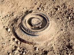
5 After 20 years? Dry Oil Lakes Wet Oil Lakes Tarcrete Mines and unexploded ordinance

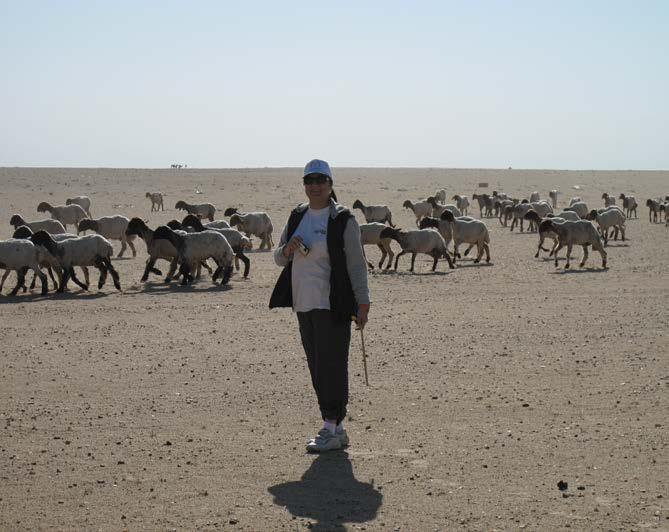
6 Human activities Camping Overgrazing


7 Background Kuwait was awarded compensation for expenses for future restoration and re-vegetation of damaged terrestrial ecosystems Umm Negga
8 Study Area Umm Nigaa Considered an open rangeland, which is distant from residential areas. The site is used for camping and grazing, as well as, some privet agriculture areas. Ministry of Defense in Kuwait established a De-Militarized Zone (DMZ)
9 Successful Restoration Planning The establishment of a successful restoration planning requires: 1. developing site history which is a critical step in ecology restoration planning since it allows researches to go backward to understand phenomena. 2. proper ecological site description. Erosion is also important for degrades sites since it ultimately degrade physical, chemical, and biological properties of the soil.
10 Objectives Using Spatial analysis and modeling to: 1. Develop site history and assess the impact of land cover change. 2. Estimating potential soil erosion.
11 Developing site history Methodology Data acquisition USGS Landsat L4-5 TM 1988, 1991, 1993, 1998 Landsat 7 ETM , and 2013 images Preprocessing File extraction, band stacking, study area extraction Supervised classification (Mahalanobis Distance method) Collect Training Regions of Interest (ROIs) in sand, bare ground, water, wetland, vegetation classes Accuracy Assessment Collect Ground Truth ROIs (50 pixels per class) Change Detection Using Mahalanobis classified images from all five years Evaluation
12 Change detection for vegetation cover % Results %

13 Change detection for vegetation cover % Results %

14 Change detection for vegetation cover 2002 Results % 23%
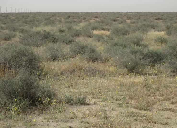
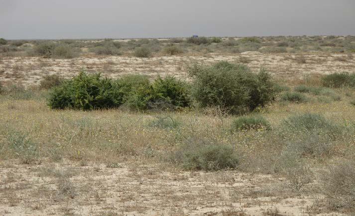
15 Restored vs DMZ Results % vegetation increase Damaged area Reference area
16 Potential Vegetation Production if Fenced and Protected Results % vegetation increase

17 Selecting Reference Area According to Soil, Geological properties, and vegetation communities, the study area was classified into 3 unites. Each unite contains Damaged and reference site.


18 Unite 1 Damaged (1) Reference (1)


19 Unite 2 Damaged (2) Reference (2)


20 Unite 3 Damaged (3) Reference (3)
21 Estimate potential soil loss Spatial analysis and modeling were using GIS environment were used to estimate potential soil loss. There are several methods that were generally used for soil erosion 1. Water Erosion Prediction Project (WEPP), 2. Universal Soil Loss Equation Method (USLE), 3. Erosion Potential Method (EPM) 4. Modified Pacific South West Inter Agency Committee Method (MPSIAC)
22 Modified Pacific South West Inter Agency Committee Method (MPSIAC) It is designed for arid and semi-arid lands. It covers large number of factors. The enhanced model is more quantitative than the earlier version and the scoring is more realistic.

23 Modified Pacific South West Inter Agency Committee Method (MPSIAC)

24 Potential soil erosion Factors were combined together to generate the final scoring, which was used in the following equation Q=38.77e R Where: Qs= total sediment yield in m3/km2/yr. e =

25 Soil erosion results

26 Estimated Soil loss Results
27 Model Testing Results Bare ground Geology Surface erosion Soil Runoff Slopes

28 Increasing Vegetation Cover Results

29 Increasing Vegetation Cover Results
30 MPASIC model vs EMP and USLE USLE MODEL Results The USLE is the most common used model since it is the most simplistic model for estimating soil erosion. This model is described by: A = R.K.LS.C.P 1. A is the average annual soil water loss in tons/ acre/ year, 2. R is the rainfall and runoff factor, 3. K is the soil erodibility factor, 4. LS is the slope length-gradient factor, and 5. C is the crop/vegetation, 6. P is the erosion control practice.
31 MPASIC model vs EMP and USLE EMP MODEL Results Estimating soil erosion using EMP model is based on the following four factors which include: 1. Y: The coefficient of rock and soil erosion, ranging from Xa: The land use coefficient, ranging from Ψ: The coefficient for present erosion type, ranging from I: Average- land slope in percentage.

32 MPASIC model vs EMP and USLE Results USLE EMP MPASIC
33 Conclusion Developing a site history is one of the most useful steps in understanding and assessing damaged ecosystem. The results demonstrates the power of utilizing remote sensing to determine site history of a desert site for a relatively large area. The results document that the effect of human activities likely decreased the natural vegetative recovery. Spatial analysis could answer simple and complex questions, as well as examining the relationship between different spatial data. MPSIAC model showed the best results for soil erosion compared with other model.
34 What s Next Conducting fieldwork to determine soil condition. Due to the high wind storms it is also important to estimate wind erosion. Applying restoration and re-vegetation plan.
35 THANK YOU
36 Methods Supervised Classification Mahalanobis Distance Method - Regions of Interest (ROIs) were collected for each of the 5 land-cover types - The normality assumption of training classes was checked for each class. - Ground Truth ROIs (for the accuracy assessment) were also created at the same time.
37 Method Accuracy Assessment Training ROIs and Ground Truth ROIs were used to assess the accuracy of Mahalanibus classified images. Overall accuracy and Kappa coefficient were obtained for each classified images. Post Classification Change Detection 1 Compared images for two different years st Gulf War at a time (ex and 1991)
38 Results and Discussion Accuracy Assessment Classified Image Year Overall Accuracy Kappa Coefficient % % % % %

39 Accuracy assessment results


40 Change detection for vegetation cover Results 35 % Vegetation n 7% Vegetation
41 Change detection for vegetation cover Results % vegetation increase Year

42 Potential Vegetation Production if Fenced and Protected Results % vegetation increase
43 Runoff Factor This factor was generated using Soil Conservation Service Curve Number Equation (SCS-CNE) model. Rainfall-runoff relationship was calculated using the following equations: Q = runoff (in), P = rainfall (in), S = potential maximum retention after runoff begins (in) and, Ia = initial abstraction (in) S is related to the soil and cover conditions of the watershed through the Curve Number (CN). CN has a range of 0 to 100, and S is related to CN by:
44 Runoff Factor The model depends on the runoff curve number (CN). the Natural Resource Conservation Service (NRCS) curve number has divided soils into four hydrologic soil groups (HSGs) based on infiltration rates.
45 MPASIC model vs EMP and USLE Results

46 Geological factor

47 Soil Factor Soil erodability map (K factor) was generated based on RUSLE k = M1.14 (1.2 a) (b 2)+3.3(c 3) 1. M is the size of soil particles 2. a is the percentage of organic matter, 3. b is soil structure, and 4. c is the soil drainage class
48 Climate Factor climatic factor rating was based on Fourier Index (FI) mm (5 inch) FI= p 2 /P Where p is the mean monthly rainfall of the wettest month, and P is the mean annual rainfall Rainfall
, P = rainfall (in), S = potential maximum retention after runoff")
49 Runoff Factor This factor was generated using Soil Conservation Service Curve Number Equation (SCS-CNE) model. Rainfall-runoff relationship was calculated using the following equations: Q = runoff (in), P = rainfall (in), S = potential maximum retention after runoff begins (in) and, Ia = initial abstraction (in)
 m (0.065 + 0.045 s + 0.")
50 Topography Factor Slope% DEM Flow Direction LS Factor Flow Accumulation LS = (Flow accumulation * Cell value /22.1) m ( s s 2 ) (Wischmeier and Smith 1978)

51 Land Cover Factor Land cover and vegetation cover were rated using MPSIAC equations: y6 0.2x6 y x7 Where X6 is bare soil %, and X7 is vegetation cover %. bare ground vegetation
 to 15 (high")
52 Surface Erosion Factor Surface erosion was rated based on Breau of Land Management (BLM) (Refahi, 2006) The location includes two types of erosion, sheet erosion and rill erosion Variables that were taken into consideration are land cover, streams, and slops Each erosion type was rated from 0 (low sensitivity) to 15 (high sensitivity)
Runoff and soil loss. (Quantification and modeling of watershed discharge and sediment yield) Kassa Tadele (Dr.Ing) Arba Minch University
 Kassa Tadele (Dr.Ing) Arba Minch University") Runoff and soil loss (Quantification and modeling of watershed discharge and sediment yield) Kassa Tadele (Dr.Ing) Arba Minch University Part I. Runoff Contents 1. Fundamental Concepts 2. Generation of
Runoff and soil loss (Quantification and modeling of watershed discharge and sediment yield) Kassa Tadele (Dr.Ing) Arba Minch University Part I. Runoff Contents 1. Fundamental Concepts 2. Generation of
ECOSYSTEM SERVICE LOSS DUE TO SOIL EROSION IN THE WATERSHED OF BINH DIEN RESERVOIR, VIETNAM NGUYEN THI MY QUYNH Supervisor: Prof.
 ECOSYSTEM SERVICE LOSS DUE TO SOIL EROSION IN THE WATERSHED OF BINH DIEN RESERVOIR, VIETNAM NGUYEN THI MY QUYNH Supervisor: Prof. KUNIHIKO YOSHINO LOCATION OF BINH DIEN RESERVOIR Importance of Binh Dien
Soil Erosion and Sediment Yield of a Sanitary Landfill Site A Case Study
 Soil Erosion and Sediment Yield of a Sanitary Landfill Site A Case Study Oon, Y.W. 1, Chin, N.J. 2 and Law, P.L. 3 Abstract - This research presents the results of a study on soil erosion rates and sediment
INTERNATIONAL JOURNAL OF CIVIL ENGINEERING AND TECHNOLOGY (IJCIET)
") INTERNATIONAL JOURNAL OF CIVIL ENGINEERING AND TECHNOLOGY (IJCIET) International Journal of Civil Engineering and Technology (IJCIET), ISSN 0976 6308 ISSN 0976 6308 (Print) ISSN 0976 6316(Online) Volume
INTERNATIONAL JOURNAL OF CIVIL ENGINEERING AND TECHNOLOGY (IJCIET) International Journal of Civil Engineering and Technology (IJCIET), ISSN 0976 6308 ISSN 0976 6308 (Print) ISSN 0976 6316(Online) Volume
Precipitation Surface Cover Topography Soil Properties
 Precipitation Surface Cover Topography Soil Properties Intrinsic capacity of rainfall to cause erosion Influenced by Amount, intensity, terminal velocity, drop size and drop size distribution of rain.
Investigation of relationships among the environmental factors and water erosion changes using EPM model and GIS
 International Research Journal of Applied and Basic Sciences. Vol., 3 (5), 945-949, 2012 Available online at http:// www. irjabs.com ISSN 2251-838X 2012 Investigation of relationships among the environmental
EROSION HAZARD MAPPING FOR MICRO-WATERSHED PRIORITIZATION USING REMOTE SENSING AND GIS TECHNIQUES
 EROSION HAZARD MAPPING FOR MICRO-WATERSHED PRIORITIZATION USING REMOTE SENSING AND GIS TECHNIQUES Dilip G. Durbude*, B. Venkatesh Hard Rock Regional Centre, National Institute of Hydrology, Hanuman Nagar,
Examination of PRZM5.0 Storm Rainfall Depth and Distribution Algorithms Compared to Current U.S. Storm Trends
 Examination of PRZM5.0 Storm Rainfall Depth and Distribution Algorithms Compared to Current U.S. Storm Trends August 24, 2016 Tammara L. Estes (Stone Environmental Inc.) Kevin L. Armbrust, Ph.D. (Louisiana
Objectives of the Study
 Integration of AGNPS, GIS, and Remote Sensing for Estimating Nonpoint Source Pollution in the Saginaw Bay, Michigan Chansheng He Department of Geograophy Western Michigan University Kalamazoo, MI 49008
Stormwater Review Part 2. Rainfall and Runoff. Tom Seybert, PE and Andy Bennett, PE. Pennsylvania Surveyors Conference 2019
 Stormwater Review Part 2 Rainfall and Runoff Tom Seybert, PE and Andy Bennett, PE Pennsylvania Surveyors Conference 2019 1 Topics Covered 1. Rainfall characteristics and sources 2. Watershed characteristics
Evaluating BMP selection and placement in intermittent channels in Fort Cobb watershed
 Evaluating BMP selection and placement in intermittent channels in Fort Cobb watershed Preliminary Research Solmaz Rasoulzadeh, Arthur Stoecker Ph.D Student, Environmental Science Professor, Agricultural
Thanks to Bill Elliot, Research Leader U.S. Department of Agriculture Forest Service
 Thanks to Bill Elliot, Research Leader U.S. Department of Agriculture Forest Service To present an overview Forest Soil Erosion Processes 2 Precipitation or melting snow Evapotranspiration Infiltration
Tropical Agro-Ecosystem Function
 Tropical Agro-Ecosystem Function Soil erosion by water and wind Dr. Ronald F. Kühne; rkuehne@gwdg.de Georg-August-University Göttingen Department for Crop Sciences Tropical Agronomy Grisebachstr. 6, 37077
GIS Based Analysis of Biophysical and Socio - Economic Factors for Land Degradation in Kandaketiya DS Division
 Tropical Agricultural Research Vol. 21(4): 361-367 (2010) GIS Based Analysis of Biophysical and Socio - Economic Factors for Land Degradation in Kandaketiya DS Division K.D.B.L. Jayarathne, N.D.K. Dayawansa
WASA Quiz Review. Chapter 2
 WASA Quiz Review Chapter 2 Question#1 What is surface runoff? part of the water cycle that flows over land as surface water instead of being absorbed into groundwater or evaporating Question #2 What are
Determining C Factor of Universal Soil Loss Equation (USLE) Based on Remote Sensing
 Based on Remote Sensing") erd Research article Determining C Factor of Universal Soil Loss Equation (USLE) Based on Remote Sensing KUANG TING KUO Graduate School of Agriculture, Tokyo University of Agriculture, Tokyo, Japan Email:
erd Research article Determining C Factor of Universal Soil Loss Equation (USLE) Based on Remote Sensing KUANG TING KUO Graduate School of Agriculture, Tokyo University of Agriculture, Tokyo, Japan Email:
Use of GIS and Remote Sensing to assess Soil Erosion in Arid to Semiarid Basin in Jordan
 Use of GIS and Remote Sensing to assess Soil Erosion in Arid to Semiarid Basin in Jordan Ibrahim Farhan and Jawad Al Bakri Dept. Land, Water & Env. Faculty of Agriculture, University of Jordan, Amman,
GIS MODELLING OF LAND DEGRADATION IN NORTHERN-JORDAN USING LANDSAT IMAGERY
 GIS MODELLING OF LAND DEGRADATION IN NORTHERN-JORDAN USING LANDSAT IMAGERY S. Essa a a Geology Department, Faculty of Science, UAE University, Al-Ain, UAE salem.essa@uaeu.ac.ae KEY WORDS: Remote Sensing,
Application of AnnAGNPS to model an agricultural watershed in East-Central Mississippi for the evaluation of an on-farm water storage (OFWS) system
 system") Application of AnnAGNPS to model an agricultural watershed in East-Central Mississippi for the evaluation of an on-farm water storage (OFWS) system Ritesh Karki a, Mary Love M. Tagert a, Joel O. Paz a,
Application of AnnAGNPS to model an agricultural watershed in East-Central Mississippi for the evaluation of an on-farm water storage (OFWS) system Ritesh Karki a, Mary Love M. Tagert a, Joel O. Paz a,
CHAPTER 4 - EROSION & SEDIMENT CONTROL AND STORMWATER MANAGEMENT ORDINANCE OF DUBUQUE COUNTY, IOWA. Adopted March 29, 2010.
 CHAPTER 4 - EROSION & SEDIMENT CONTROL AND STORMWATER MANAGEMENT ORDINANCE OF DUBUQUE COUNTY, IOWA Adopted March 29, 2010 Table of Contents Page Part 1 Introduction...3 4-1 Title..................3 4-2
CHAPTER ONE : INTRODUCTION
 CHAPTER ONE : INTRODUCTION WHAT IS THE HYDROLOGY? The Hydrology means the science of water. It is the science that deals with the occurrence, circulation and distribution of water of the earth and earth
Environmental Risk Management of diffuse pollution of mining origin
 GREEN 5, Vilnius 1-4 July, 2008 Environmental Risk Management of diffuse pollution of mining origin Emese Vaszita, Katalin Gruiz, Zoltán Siki, Viktória Feigl Budapest University of Technology and Economics,
Prioritizing Water-Quality Improvement Efforts on Agricultural Lands Using LiDAR Elevation Data
 Prioritizing Water-Quality Improvement Efforts on Agricultural Lands Using LiDAR Elevation Data Aaron Ruesch and Theresa Nelson Wisconsin Department of Natural Resources WLWCA March 11, 2014 Outline WLWCA
Statewide Ranking of Ecological Value of CRP and other Critical Lands
 Statewide Ranking of Ecological Value of CRP and other Critical Lands Funded by ENRTF as recommended by LCCMR 2008 2009 D. J. Mulla, S. J. Taff, G. Host, J. Galzki, T. Brown, A. Lewandowski, and J. Nelson
AnnAGNPS. Annualized AGricultural Non-Point Source Pollurant Loading Model. Annualized Agricultural Non-Point Source Pollutant Loading Model
 AnnAGNPS Annualized AGricultural Non-Point Source Pollurant Loading Model 1 Erosion Erosion can be expresed as: E=f(C, S, T, SS, M) E = erosion C = climate S = soil properties T = topography SS = soil
Effect of Land Surface on Runoff Generation
 Effect of Land Surface on Runoff Generation Context: Hydrologic Cycle Runoff vs Infiltration Infiltration: Process by which water on the ground surface enters the soil Runoff: Water (from rain, snowmelt,
What is a Watershed? Understanding Surface Runoff. Controlling Erosion and Sediment.
 What is a Watershed? Understanding Surface Runoff. Controlling Erosion and Sediment. Aleksey Sheshukov Assistant Professor and Water-Quality Specialist Biological & Agricultural Engineering ashesh@ksu.edu,
Mission. Selected Accomplishments from Walnut Gulch. Facilities. To develop knowledge and technology to conserve water and soil in semi-arid lands
 USDA-ARS Southwest Watershed Research Center Mission Sound Science for Watershed Decisions To develop knowledge and technology to conserve water and soil in semi-arid lands ARS Watershed Locations Selected
OVERVIEW OF RUSLE 2 DICK WOLKOWSKI DEPT. OF SOIL SCIENCE UW-MADISON
 OVERVIEW OF RUSLE 2 DICK WOLKOWSKI DEPT. OF SOIL SCIENCE UW-MADISON WHAT IS RUSLE 2 GREAT GRANDSON OF USLE MODEL TO PREDICT SOIL LOSS WHERE OVERLAND FLOW OCCURS COMPUTES ANNUAL SHEET/RILL EROSION COMPUTES
Appendix D. Erosion Management Sub- Plan
 Appendix D Erosion Management Sub- Plan DRENNAN SOLAR ENERGY FACILITY EROSION MANAGEMENT PLAN PRODUCED FOR ERM ON BEHALF OF SOLAIREDIRECT BY Simon.Todd@3foxes.co.za JUNE 2013 PURPOSE The purpose of the
Using GIS to Estimate Soil Loss Rates in Denton County, Texas
 Using GIS to Estimate Soil Loss Rates in Denton County, Texas Bill Forbes, Laura Davenport, Bill Cruce, and Kenneth Yazel Advanced Geographic Information Systems Dr. Minhe Ji Spring 2001 Research Problem
ORDINANCE APPENDIX C RUNOFF COEFFICIENTS AND CURVE NUMBERS
 ORDINANCE APPENDIX C RUNOFF COEFFICIENTS AND CURVE NUMBERS TABLE C-1. RUNOFF CURVE NUMBERS Source: Table 2-2a, Table 2-2b, and Table 2-2c from U. S. Department of Agriculture, Natural Resources Conservation
Modeling the Hydrologic Impacts of Control Structures Utilizing LiDAR, ICPR, and GIS Technologies
 Modeling the Hydrologic Impacts of Control Structures Utilizing LiDAR, ICPR, and GIS Technologies Keanan Bell NorthStar June 12, 2015 Project began in 2010 as a Hydrology Assessment and Conceptual Restoration
0.0. Pervious CN = 40. (Unconnected impervious) (Total impervious) Total impervious area (percent) Composite CN
 (Total impervious) Total impervious area (percent) Composite CN") Figure 2-3 Composite CN with connected impervious area. 100 Composite CN 90 80 70 60 Pervious CN = 90 80 70 60 50 40 50 40 0 10 20 30 40 50 60 70 80 90 100 Connected impervious area (percent) Figure 2-4
Figure 2-3 Composite CN with connected impervious area. 100 Composite CN 90 80 70 60 Pervious CN = 90 80 70 60 50 40 50 40 0 10 20 30 40 50 60 70 80 90 100 Connected impervious area (percent) Figure 2-4
Definitions. Assessment. Definitions of attributes
 Definitions Assessment Monitoring sampling at two points in time usually as part of management plan (to see if goals are being met) Inventory sampling to see what occurs on a site usually a single time
STANDARDS FOR HEALTHY PUBLIC RANGELANDS
 STANDARDS FOR HEALTHY PUBLIC RANGELANDS Standard #1 Within the potential of the ecological site (soil type, landform, climate, and geology), soils are stable and allow for water infiltration to provide
Integrating GIS and Erosion Modeling: A Tool for Watershed Management
 ESRI 2007 International User Conference Paper No. UC1038 Introduction Integrating GIS and Erosion Modeling: A Tool for Watershed Management David J. Wachal, City of Denton Water Utilities Kenneth E. Banks,
HYDROLOGY WORKSHEET 1 PRECIPITATION
 HYDROLOGY WORKSHEET 1 PRECIPITATION A watershed is an area of land that captures rainfall and other precipitation and funnels it to a lake or stream or wetland. The area within the watershed where the
CATCHMENT AREA TREATMENT PLAN
 CATCHMENT AREA TREATMENT PLAN 1 NEED FOR CATCHMENT AREA TREATMENT It is a wellestablished fact that reservoirs formed by dams on rivers are subjected to sedimentation. The process of sedimentation embodies
[Suryawanshi 4(9): September 2017] ISSN DOI /zenodo Impact Factor
![[Suryawanshi 4(9): September 2017] ISSN DOI /zenodo Impact Factor](/thumbs/89/99073782.jpg "[Suryawanshi 4(9): September 2017] ISSN DOI /zenodo Impact Factor") GLOBAL JOURNAL OF ENGINEERING SCIENCE AND RESEARCHES ENVIRONMENTAL ASSESSMENT OF SOIL EROSION ON LAKNAVARAM LAKE BASIN Vijay Suryawanshi *1, D. Manaswini 2 and P.Pravalika 3 *1 Assistant Professor, KITS-Warangal,
GLOBAL JOURNAL OF ENGINEERING SCIENCE AND RESEARCHES ENVIRONMENTAL ASSESSMENT OF SOIL EROSION ON LAKNAVARAM LAKE BASIN Vijay Suryawanshi *1, D. Manaswini 2 and P.Pravalika 3 *1 Assistant Professor, KITS-Warangal,
BAEN 673 / February 18, 2016 Hydrologic Processes
 BAEN 673 / February 18, 2016 Hydrologic Processes Assignment: HW#7 Next class lecture in AEPM 104 Today s topics SWAT exercise #2 The SWAT model review paper Hydrologic processes The Hydrologic Processes
Integrated Landscape Monitoring: Prairie Pilot
 Integrated Landscape Monitoring: Prairie Pilot Prairie Pilot Science Team U.S. Department of the Interior U.S. Geological Survey JUSTIFICATION & NEED USDA Agency influences 400 million acres of cropland
THE FIRST IRAQI NATIONAL REPORT TO THE CONVENTION ON BIOLOGICAL DIVERSITY
 THE FIRST IRAQI NATIONAL REPORT TO THE CONVENTION ON BIOLOGICAL DIVERSITY CHAPTER I BIODIVERSITY VALUES MARSH Most Most important fresh fresh and and brackish water water system of of the the region Breeding
INTRODUCTION cont. INTRODUCTION. What is Impervious Surface? Implication of Impervious Surface
 Mapping Impervious Surface Changes In Watersheds In Part Of South Eastern Region Of Nigeria Using Landsat Data By F. I. Okeke Department of Geoinformatics and Surveying, University of Nigeria, Enugu Campus
Pennsylvania Stormwater Best Management Practices Manual. Chapter 3. Stormwater Management Principles and Recommended Control Guidelines
 Pennsylvania Stormwater Best Management Practices Manual Chapter 3 Stormwater Management Principles and Recommended Control Guidelines 363-0300-002 / December 30, 2006 Chapter 3 Stormwater Management Principles
SURFACE RUNOFF ESTIMATION BY SCS CURVE NUMBER METHOD USING GIS FOR RUPEN-KHAN WATERSHED, MEHSANA DISTRICT, GUJARAT
 J. Indian Water Resour. Soc., Vol. 36, No. 4, Oct., 2016 SURFACE RUNOFF ESTIMATION BY SCS CURVE NUMBER METHOD USING GIS FOR RUPEN-KHAN WATERSHED, MEHSANA DISTRICT, GUJARAT Dhvani Tailor 1 and Narendra
Application of N-SPECT model and GIS for Soil erosion assessment in Sapa district, Lao Cai province
 VNU Journal of Science, Earth Sciences 27 (2011) 199-207 Application of N-SPECT model and GIS for Soil erosion assessment in Sapa district, Lao Cai province Nguyen Hieu*, Dang Kinh Bac, Dang Van Bao Faculty
D Olive Watershed. Path Toward Restoration
 D Olive Watershed Path Toward Restoration Water is the most critical resource issues of our lifetime and our children s lifetime. The health of our waters is the principal measure of how we live on the
Preliminary assessment of soil erodibility can be investigated with soil plasticity properties (Section 4.4.3).
.") 6.0 SITE EROSION POTENTIAL 6.1 General The foremost challenge facing the designer is to correctly assess the erosion potential resulting from the construction activities. The site erosion potential is
6.0 SITE EROSION POTENTIAL 6.1 General The foremost challenge facing the designer is to correctly assess the erosion potential resulting from the construction activities. The site erosion potential is
STORMWATER RUNOFF AND WATER QUALITY IMPACT REVIEW
 SUBCHAPTER 8 STORMWATER RUNOFF AND WATER QUALITY IMPACT REVIEW 7:45-8.1 Purpose and scope of review Except for those projects expressly exempted by this chapter or waived by the Commission, the Commission
Models Overview: Purposes and Limitations
 Models Overview: Purposes and Limitations Pollutant load originates from: Point-source discharges (NPDES facilities) Info is available on the discharges (DMRs, etc.) Some are steady-flow, others are precip-driven
Pat L. Shaver USDA-NRCS-WNTSC Portland, OR
 Pat L. Shaver USDA-NRCS-WNTSC Portland, OR Process to collect and document professional knowledge and observations on selected indicators and attributes of rangeland health. How Ecological Processes are
CENTRAL COAST POST-CONSTRUCTION REQUIREMENTS IMPLEMENTATION GUIDANCE SERIES 1
 CENTRAL COAST POST-CONSTRUCTION REQUIREMENTS IMPLEMENTATION GUIDANCE SERIES 1 SERIES ISSUE #2: DECENTRALIZED STORMWATER MANAGEMENT TO COMPLY WITH RUNOFF RETENTION POST-CONSTRUCTION STORMWATER CONTROL REQUIREMENTS
L-THIA Online and LID in a watershed investigation
 L-THIA Online and LID in a watershed investigation Larry Theller Agricultural and Biological Engineering, Purdue University Great Lakes Sedimentation Workshop Ann Arbor Mi. L-THIA On-line watershed delineation
Basic Hydrology Runoff Curve Numbers
 Basic Hydrology Runoff Curve Numbers By: Paul Schiariti, P.E., CPESC Mercer County Soil Conservation District The SCS Runoff Curve Number The RCN (Runoff Curve Number) method was originally established
Introduction. The Universal Soil Loss Equation (USLE, Wischmeir and Smith, 1978), including the revised version of it (RUSLE, Renard et al.
, including the revised version of it (RUSLE, Renard et al.") Comparison of the abilities of the Q R EI 3 index and the EI 3 index to estimate event erosion on bare fallow plots P.I.. Kinnell University of Canberra Introduction The Universal Soil Loss Equation (USLE,
Comparison of the abilities of the Q R EI 3 index and the EI 3 index to estimate event erosion on bare fallow plots P.I.. Kinnell University of Canberra Introduction The Universal Soil Loss Equation (USLE,
Application of RUSLE Model on Global
 Annual Journal of Hydraulic Engineering, JSCE, VOL.45, 2001, February Application of RUSLE Model on Global Soil Erosion Estimate Thai Nam PHAM1, Dawen YANG2, Shinjiro KANAE3, Taikan OKI4, and Katumi MUSIAKE5
Peak discharge computation
 Ia/P 4 Peak Dischage Method Graphical Peak Discharge Method This chapter presents the Graphical Peak Discharge method for computing peak discharge from rural and urban areas. The Graphical method was developed
Environmental Resource Inventories. What are ERIs? Significance of information How to use them
 Environmental Resource Inventories What are ERIs? Significance of information How to use them Environmental Resource Inventory - ERI Compiled by the environmental commission Information about the natural
Ponds Planning, Design, Construction
 United States Department of Agriculture Natural Resources Conservation Service Ponds Planning, Design, Construction Agriculture Handbook Number 590 Estimating storm runoff The amount of precipitation,
SUMMARY OF CUMULATIVE WATERSHED EFFECTS PROCESS
 SUMMARY OF CUMULATIVE WATERSHED EFFECTS PROCESS KLAMATH NATIONAL FOREST PREPARED BY: ANGIE BELL, FOREST GEOLOGIST 12 OCTOBER 2012 INTRODUCTION The Klamath National Forest currently utilizes three separate
Runoff Hydrographs. The Unit Hydrograph Approach
 Runoff Hydrographs The Unit Hydrograph Approach Announcements HW#6 assigned Storm Water Hydrographs Graphically represent runoff rates vs. time Peak runoff rates Volume of runoff Measured hydrographs are
2015 International SWAT Conference Sardinia, Italy Date: (24 th June 2015)
") 2015 International SWAT Conference Sardinia, Italy Date: (24 th June 2015) By Pratiksha Jain Research Scholar Remote Sensing Applications Group Department of Civil Engineering Indian Institute of Technology
2015 International SWAT Conference Sardinia, Italy Date: (24 th June 2015) By Pratiksha Jain Research Scholar Remote Sensing Applications Group Department of Civil Engineering Indian Institute of Technology
WMS Tools For Computing Hydrologic Modeling Parameters
 WMS Tools For Computing Hydrologic Modeling Parameters Lesson 9 9-1 Objectives Use the drainage coverage as a basis for geometric parameters as well as overlaying coverages to compute important hydrologic
A Study of Himreen Reservoir Water Quality Using in Situ Measurement and Remote Sensing Techniques
 A Study of Himreen Reservoir Water Quality Using in Situ Measurement and Remote Sensing Techniques Dr. Salah A. H. Saleh College of Science, Nahrain University, Baghdad - IRAQ Abstract The use of remote
ROADS: OPERATION AND MAINTENANCE
 ROADS: OPERATION AND MAINTENANCE GEMS Environmental Compliance- ESDM Training Series Kabul July / August 2016 8/1/2016 1 ROADS AND DEVELOPMENT Improved access = benefits across economic sectors Service
Rangeland Watersheds. Maintenance and provision of genetic resources Maintenance and regeneration of habitat Provision of shade and shelter
 Rangeland Watersheds What is a Watershed? A surface water designation The area that flows into a distinct drainage (i.e., stream, river, creek, pond) Separated from other watershed by ridge-top boundaries.
Runoff Processes. Daene C. McKinney
 CE 374 K Hydrology Runoff Processes Daene C. McKinney Watershed Watershed Area draining to a stream Streamflow generated by water entering surface channels Affected by Physical, vegetative, and climatic
Assistant Professor, Anand Agricultural University, Anand 2. Principal and Dean, Anand Agricultural University, ANand 2
 15 th Esri India User Conference 214 IMPACT ASSESSMENT OF LAND USE CHANGE ON RUNOFF GENERATION USING REMOTE SENSING & GEOGRAPHICAL INFORMATION SYSTEMS Mukesh K. Tiwari 1, M. L. Gaur 2, Pappu Ram Siyag
Restoration of Riparian Areas Following the Removal of Cattle in the Northwestern Great Basin
 Restoration of Riparian Areas Following the Removal of Cattle in the Northwestern Great Basin Jonathan L. Batchelor 1 William J. Ripple 1 Todd M. Wilson 2 Luke E. Painter 3 1. Department of Forest Ecosystems
Model Development and Applications at the USDA-ARS National Soil Erosion Research Laboratory. Dennis C. Flanagan
 Model Development and Applications at the USDA-ARS National Soil Erosion Research Laboratory Dennis C. Flanagan Research Agricultural Engineer USDA-Agricultural Research Service Adjunct Professor Purdue
Managing Upland Grazing to Restore Soil Health and Farm Livelihoods
 Managing Upland Grazing to Restore Soil Health and Farm Livelihoods Richard Teague, Texas A&M AgriLife Research Wimberley, Texas 30 th September 2016 Carbon rich soil: Benefits the entire ecosystem Healthy
Watershed Management Prof. T. I. Eldho Department of Civil Engineering Indian Institute of Technology, Bombay
 Watershed Management Prof. T. I. Eldho Department of Civil Engineering Indian Institute of Technology, Bombay Lecture No. # 06 Soil Erosion and Conservation And welcome back to the video course on watershed
Infiltration Basin Description Applicability
 Infiltration Basin Description An infiltration basin is a shallow impoundment which is designed to infiltrate storm water into the ground water. This practice is believed to have a high pollutant removal
What is runoff? Runoff. Runoff is often defined as the portion of rainfall, that runs over and under the soil surface toward the stream
 What is runoff? Runoff Runoff is often defined as the portion of rainfall, that runs over and under the soil surface toward the stream 1 COMPONENTS OF Runoff or STREAM FLOW 2 Cont. The types of runoff
LAKE COUNTY HYDROLOGY DESIGN STANDARDS
 LAKE COUNTY HYDROLOGY DESIGN STANDARDS Lake County Department of Public Works Water Resources Division 255 N. Forbes Street Lakeport, CA 95453 (707)263-2341 Adopted June 22, 1999 These Standards provide
1. Stream Network. The most common approach to quantitatively describing stream networks was postulated by Strahler (1952).
.") 1. Stream Network The most common approach to quantitatively describing stream networks was postulated by Strahler (1952). First Order Streams streams with no tributaries. Second Order Streams begin at
1. Stream Network The most common approach to quantitatively describing stream networks was postulated by Strahler (1952). First Order Streams streams with no tributaries. Second Order Streams begin at
Evaluation of Empirical and Nomograph Method of Predicting Erodibility Index for Selected Savannah Soils.
 Evaluation of Empirical and Nomograph Method of Predicting Erodibility Index for Selected Savannah Soils. A.I. Arab, M.Sc. 1* ; Prof. S.Z. Abubakar 1 ; and U.D. Idris, M.Sc. 2 1 National Agricultural Extension
IJSER. within the watershed during a specific period. It is constructed
 International Journal of Scientific & Engineering Research, Volume 5, Issue 7, July-014 ISSN 9-5518 306 within the watershed during a specific period. It is constructed I. INTRODUCTION In many instances,
Ecological Site Descriptions and Hydrologic Assessment
 Ecological Site Descriptions and Hydrologic Assessment Frederick B. Pierson Research Leader and Rangeland Hydrologist USDA Agricultural Research Service Northwest Watershed Research Center, Boise, Idaho
MODULE 1 RUNOFF HYDROGRAPHS WORKSHEET 1. Precipitation
 Watershed MODULE 1 RUNOFF HYDROGRAPHS WORKSHEET 1 A watershed is an area of land thaaptures rainfall and other precipitation and funnels it to a lake or stream or wetland. The area within the watershed
Impact of Increased Stormwater Runoff on Urban Drainage Systems
 Impact of Increased Stormwater William E. Spearman, III, PE APWA Stormwater Summit San Antonio, TX September 12, 2007 Contact Information: William E. Spearman, III, PE Member, APWA National Water Resources
2.3 Water Budget Data In Ontario
 2.3 Water Budget Data In Ontario Water budget data available for Ontario includes meteorologic data, hydrometric data and groundwater data. Geological and physiographical data provide information to describe
Center for Ecological Management of Military Lands Department of Forest Science, Colorado State University Fort Collins, CO 80523
 Calculating Revised Universal Soil Loss Equation (RUSLE) Estimates on Department of Defense Lands: A Review of RUSLE Factors and U.S. Army Land Condition-Trend Analysis (LCTA) Data Gaps Center for Ecological
Sustainable STEM Series
 W 338-C Sustainable STEM Series Science, Technology, Engineering and Mathematics for a Sustainable Future All over the media are reports that the United States is falling behind other countries in the
Black River Watershed Management Plan Plan
 Black River Watershed Management Plan Plan Final Report Part II: Appendices May 2010 This watershed management plan was prepared for the New York State Department of State Division of Coastal Resources
SWRC Mission. ARS Research In General. Selected Accomplishments from Walnut Gulch
 USDA-ARS Southwest Watershed Research Center SWRC Mission Sound Science for Watershed Decisions To develop knowledge and technology to conserve water and soil in semi arid lands ARS Research In General
USDA-ARS Southwest Watershed Research Center. Sound Science for Watershed Decisions. SWRC Mission
 USDA-ARS Southwest Watershed Research Center Sound Science for Watershed Decisions SWRC Mission To develop knowledge and technology to conserve water and soil in semi arid lands ARS Research In General
Modeling Nutrient and Sediment Losses from Cropland D. J. Mulla Dept. Soil, Water, & Climate University of Minnesota
 Modeling Nutrient and Sediment Losses from Cropland D. J. Mulla Dept. Soil, Water, & Climate University of Minnesota Watershed Management Framework Identify the problems and their extent Monitor water
Prairie Hydrological Model Study Progress Report, April 2008
 Prairie Hydrological Model Study Progress Report, April 2008 Centre for Hydrology Report No. 3. J. Pomeroy, C. Westbrook, X. Fang, A. Minke, X. Guo, Centre for Hydrology University of Saskatchewan 117
Watershed BMPs. Notes from NRCS online site on BMPs. Focus on key BMPs
 Notes from NRCS online site on BMPs http://www.nrcs.usda.gov/technical/standards/nhcp.html Focus on key BMPs Function, benefits, and drawbacks listed Definition Novotny & Olem: BMPs are methods and practices
Estimation of Runoff for Agricultural Watershed and Silt Load Assessment
 Estimation of Runoff for Agricultural Watershed and Silt Load Assessment Asmita B. Lakhote 1 Dr. B.V.Khode 2 Er.N.Z.Baisware 3 M.Tech (Environmental Engineering), Department of Civil Engineering, Irrigation
Design Example Residential Subdivision
 Design Example Residential Subdivision Rhode Island Stormwater Design and Installation Standards Manual December 2010 Public Training March 22, 2010 Richard Claytor, P.E. 508-833-6600 Appendix D: Site
Total Tons Stored: Total Tons Sequestered (Annually):
:") The CDP of Woodbridge, VA Rapid Ecosystem Analysis for 1992 Cropland: Pasture/Hay 602.7 8.7% Cropland: Row Crops 4.0 0.1% Forest: Deciduous Forest 1,809.3 26.3% Forest: Evergreen Forest 97.8 1.4% Forest:
The CDP of Woodbridge, VA Rapid Ecosystem Analysis for 1992 Cropland: Pasture/Hay 602.7 8.7% Cropland: Row Crops 4.0 0.1% Forest: Deciduous Forest 1,809.3 26.3% Forest: Evergreen Forest 97.8 1.4% Forest:
IJSRD - International Journal for Scientific Research & Development Vol. 3, Issue 03, 2015 ISSN (online):
:") IJSRD - International Journal for Scientific Research & Development Vol. 3, Issue 03, 2015 ISSN (online): 2321-0613 Estimation of Soil Erosion for Vishwamitri River Watershed Using Universal Soil Loss
IJSRD - International Journal for Scientific Research & Development Vol. 3, Issue 03, 2015 ISSN (online): 2321-0613 Estimation of Soil Erosion for Vishwamitri River Watershed Using Universal Soil Loss
Capturing Storm Water in Semi-arid Climate
 Capturing Storm Water in Semi-arid Climate REBEKA SULTANA, PHD CALIFORNIA STATE UNIVERSITY, LONG BEACH NATHANIEL SUMMERVILLE, PE CALIFORNIA STATE UNIVERSITY LONG BEACH (STUDENT PROJECT MANAGER) AND CH2M
Estimation of Infiltration Parameter for Tehri Garhwal Catchment
 Estimation of Infiltration Parameter for Tehri Garhwal Catchment Ashish Bhatt 1 H L Yadav 2 Dilip Kumar 3 1 UG Student, Department of civil engineering, G B Pant Engineering College, Pauri, UK-246194 2,3
Phosphorus Site Index (PSI) and the Phosphorus Management Tool (PMT)
 and the Phosphorus Management Tool (PMT)") Phosphorus Site Index (PSI) and the Phosphorus Management Tool (PMT) Patricia Steinhilber Department of Environmental Science & Technology Agricultural Nutrient Management Program University of Maryland
Phosphorus Site Index (PSI) and the Phosphorus Management Tool (PMT) Patricia Steinhilber Department of Environmental Science & Technology Agricultural Nutrient Management Program University of Maryland
Appendix C Little Calumet River Watershed Curve Number Calculation
 Little Calumet River Watershed Curve Number Calculation Introduction SCS hydrology uses the empirical curve number (CN) parameter as a part of calculating runoff volumes based on landscape characteristics
Project Priority List scoring worksheet - stormwater Guidance document
 www.pca.state.mn.us Project Priority List scoring worksheet - stormwater Guidance document PLEASE NOTE: THE MINNESOTA STATE FISCAL YEAR IS FROM JULY 1 JUNE 30 The first step towards receiving either a