The role of riparian climate corridors in promoting ecological resilience
|
|
|
- Lauren Fisher
- 6 years ago
- Views:
Transcription

1 The role of riparian climate corridors in promoting ecological resilience DAVID PATRICK & MARK ANDERSON
2
3 Acknowledgements Mark Anderson and his team 75 scientists, 8 years of work

4 The world is changing


5 Plants and animals must adapt or relocate
6 Key question How do we ensure that the places we conserve today will support a diversity of plants and animals in the future?

7 Conserving fundamental processes
8 Steps in the process 1. Climate-Resilient Sites: Identify natural climate strongholds 2. Connected landscapes: Map the critical connecting features needed for dispersal among climate resilient sites
9 Resilient Sites HOW CAN WE IDENTIFY SITES WHERE BIODIVERSITY IS LIKELY TO BE ABLE TO PERSIST IN THE FACE OF CLIMATE CHANGE?
10 Local redistribution

11 What creates natural resilience? Many microclimates leading to landscape diversity Topography Elevation range Wetlands Soils

12 Landscape diversity is only useful if organisms can access better conditions Local connectedness Less fragmented areas are more connected

13 Landscape Diversity Microclimate Estimates Every 30 m cell gets a score based on - Landform variety - Elevation range - Wetland Density - Soil Variety


14 Local Connectedness Connectedness Estimates For every 30 m cell based on roads, development, agricultures in a 3 K radius


15 Areas for each Geophysical Setting with the highest landscape diversity and the highest local connectedness Resilience Index 100 acre
16 Resilient and Connected Landscapes HOW DO WE ENSURE THAT BIODIVERSITY CAN REDISTRIBUTE IN A CHANGING WORLD?
17 Conserving resilient sites can help biodiversity persist in the face of short-term change However, in the long term most organisms will need to redistribute beyond local microclimates to survive climate change This involves dispersing to newly suitable habitat
18 What factors influence the likelihood of dispersal? Distance Source Permeability Unoccupied habitat Resilient sites Resilient sites


19 How we identified connecting landscapes Used Circuitscape Imagines current passing through landscape Suitable habitat allows current to flow more easily Habitat alteration creates anthropogenic resistance, reducing flow Not focused on specific terrestrial species, but general premise that intact natural habitat facilitates dispersal Inlandbays.org

20


21 Beyond habitat suitability: dispersal in an era of climate change 754 species 5 taxa Median of 11.0m uphill/decade ~65% of species shifted upslope* ~25% of species shifted downslope* Chen, I. C. et al Rapid range shifts of species associated with high levels of climate warming. Science, 333(6045), Meta-analysis of over 51 studies. *Illustrative, non-comprehensive survey of published literature. Lenoir et al Going against the flow: potential mechanisms for unexpected downslope range shifts in a warming climate. Ecography, 33(2),

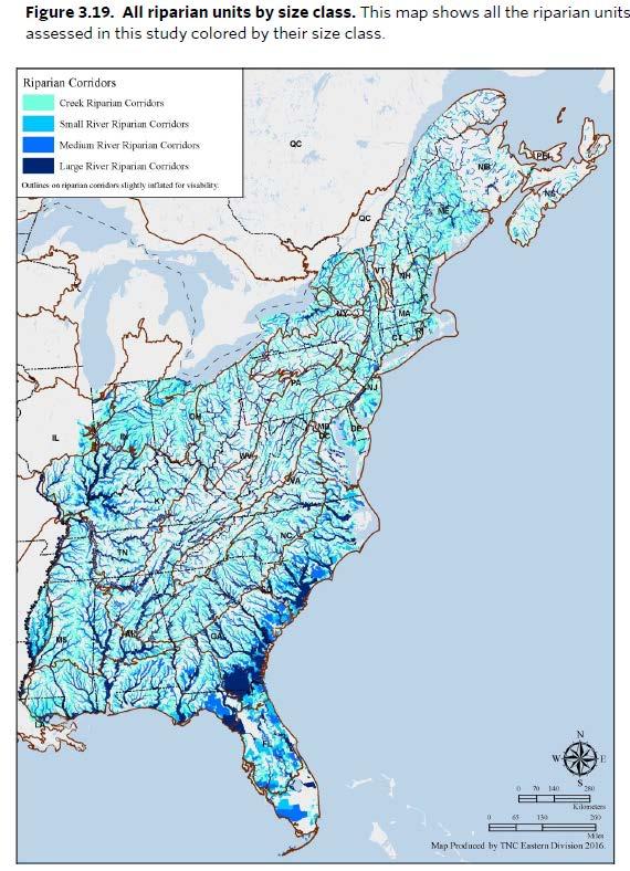
22 Weighted connectivity Upslope, northward and anthropogenic model. Circuitscape analysis applied to a resistance grid derived from landforms and anthropogenic resistance, with northward flows given twice the weight of eastwest flows. Areas of high current flow are predicted to be important for upslope range shifts
23 Riparian habitat and resilience IDENTIFYING PRIORITY RIPARIAN AREAS FOR CLIMATE ADAPTATION
24 Riparian habitat as resilient sites Resilient sites analysis coincidentally identified many riparian corridors as key landscape features in providing climate adaptation due to: Microclimates cooler (5-20 C) and more humid (10-15% higher) than surrounding areas Often high densities of wetlands (contributing to more microclimates) Great regulation/protection of riparian habitat leading to higher local connectivity scores

25
26

27 Why raise the profile of riparian habitat in our climate resilience models? High species richness and associated/obligate species Regulation/protection of riparian habitat coupled with high conversion rates of surrounding areas leading to de facto corridors Often higher densities of wetlands, allowing leapfrog dispersal for dispersallimited wetland species


28 Riparian habitat as climate corridors
29 Approach to identifying riparian habitat protection priorities Model based on Active River Area (meander belt, riparian wetlands, and 100-yr floodplain) Omitted small headwater streams as riparian areas not easily differentiated from surrounding forest Four classes: Creek Small River Medium River Large River 30-m scale analysis
30 Riparian unit attributes Size of riparian unit in acres: Larger patch size, higher value for biodiversity Regional flow from Circuitscape modeling (anthropogenic resistance only): High flow indicates concentrated species movement Contrast. Local connectedness in riparian unit compared to surrounding buffer (2.5km for creeks and small rivers, 5km for medium and large rivers): Higher contrast indicates greater value of riparian habitat as refuge and for connectivity Resilience. % of riparian area with above average resilience
31

32
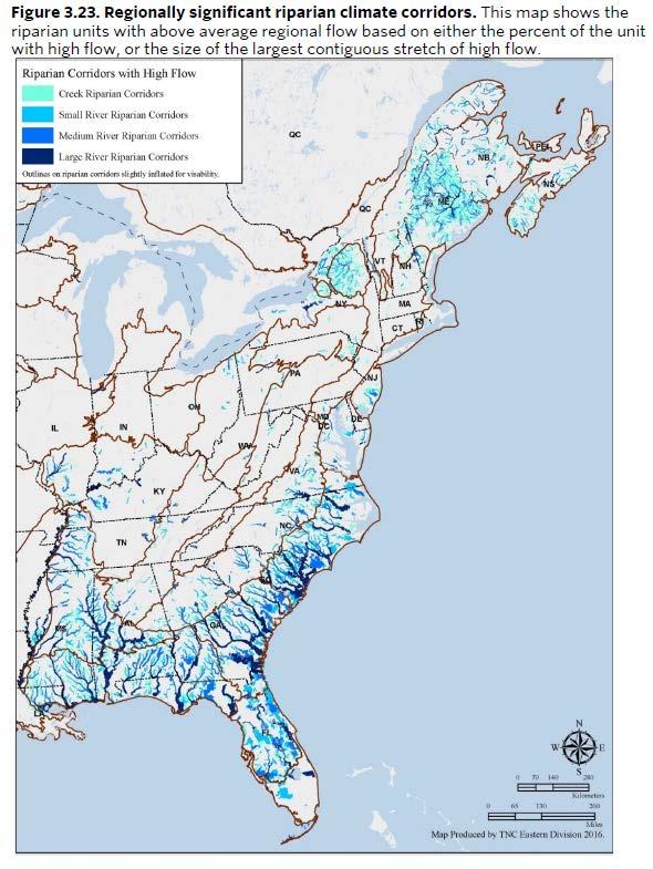
33 Final query Identify regionally significant riparian corridors that connect other resilient areas. Limited selection to: Riparian units >1000 acres in size Units that had a high percentage of area in above average regional flow or that contained a large contiguous area of high regional flow.
34

35
36 Bringing it all together


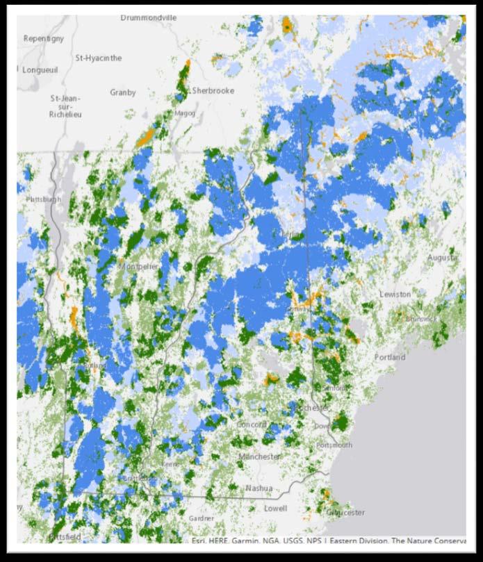
37 Resilient and Connected Landscapes
38 Take Home Messages Tool for identifying land protection priorities for TNC and partners Riparian habitat can play an important role in climate resilience including As resilient sites and potential refugia Serving as corridors for dispersal of wetland-associated species Providing corridors for movement of organisms in otherwise altered landscapes

39 Thanks and Questions
Integration of climate change adaptation : site and landscape responses. Simon Duffield Natural England
 Integration of climate change adaptation : site and landscape responses Simon Duffield Natural England Present more in detail the topics on which the Convention should work, explaining why it would be
Wetland Jurisdictional Size Comparisons Multiple Jurisdictions Jurisdiction Name (Year Jurisdictional Wetland Size Notes
 1 Thurston County Planning Commission April 6, 2011 Meeting Wetland Jurisdictional Size Comparisons Multiple Jurisdictions Jurisdiction Name (Year Jurisdictional Wetland Size Notes Adopted/Amended) (SF
Day 1 Workshop Activities 1 & 2: Habitats and Species/Species Groups
 Day 1 Workshop Activities 1 & 2: Habitats and Species/Species Groups Instructions for Small Group Discussions Divide up into umbrella habitats groups A & B Upland Desert/Grassland Wetland Riparian/Riverine
Water and Watersheds. Data Maps Action
 Water and Watersheds Data Maps Action What is the Wildlife Action Plan? Restore rare wildlife and habitats. Keep common species common. 2015 Revision: Partners in Conservation Science 2015 Revision Data
Tim Hayden, Yurok Tribe Natural Resources Division Mat Millenbach, Western Rivers Conservancy Sarah Beesley, Yurok Tribal Fisheries Program
 BLUE CREEK FOREST SANCTUARY: RESTORING OLD GROWTH FOREST ECOSYSTEM FUNCTION, PROTECTING SALMON, WILDLIFE, AND TRADITIONAL- LIFE WAYS AND CULTURE IN THE FACE OF CLIMATE CHANGE Tim Hayden, Yurok Tribe Natural
The status of aquatic ecosystems in the Basin
 AQUATIC SPECIES AND HABITATS The status of aquatic ecosystems in the Basin is influenced by both natural and human processes. The geologic and geomorphic processes described earlier formed and continue
Building Resilient Communities - Low Impact Development and Green Infrastructure Strategies
 Building Resilient Communities - Low Impact Development and Green Infrastructure Strategies October 24, 2013 Bridgewater State University E. Heidi Ricci Senior Policy Analyst Mass Audubon Shaping the Future
JAMES J. ROBERTS. U.S. Geological Survey
 JAMES J. ROBERTS U.S. Geological Survey U.S. Department of the Interior U.S. Geological Survey Climate change and Cutthroat Trout conservation in the Southern Rocky Mountains (SRM) James J. Roberts USGS
Habitat Loss and Fragmentation
 Habitat Loss and Fragmentation Fuente: Center for Biodiversity and Conservation What is: Habitat Fragmentation? The end result of human settlement and resource extraction in a landscape is a patchwork
A Freshwater Blueprint for Maritime Canada
 A Freshwater Blueprint for Maritime Canada Union of Nova Scotia Municipalities (UNSM) November 8 th, 2017 William Millar Aquatic Conservation Biologist william.millar@natureconservancy.ca Craig Smith Conservation
A Salt Marsh Advancement Zone Assessment of West Haven, Connecticut
 A Salt Marsh Advancement Zone Assessment of West Haven, Connecticut Front cover image: Open space and unprotected parcels critical to the conservation of marsh advancement corridors in West Haven; from
A STATEWIDE APPROACH FOR IDENTIFYING POTENTIAL AREAS FOR WETLAND RESTORATION AND MITIGATION BANKING IN GEORGIA: AN ECOSYSTEM FUNCTION APPROACH
 A STATEWIDE APPROACH FOR IDENTIFYING POTENTIAL AREAS FOR WETLAND RESTORATION AND MITIGATION BANKING IN GEORGIA: AN ECOSYSTEM FUNCTION APPROACH Elizabeth A. Kramer and Steven Carpenedo AUTHORS: University
8/5/2011. Lesson Overview. Disturbance/Fragmentation. Shifting Mosaic. Number one cause of biodiversity loss. Types of disturbance. - Scale, frequency
 Lesson Overview Disturbances Fragmentation Types Measuring Corridors Effects Texas Example 1 Shifting Mosaic Landscape a shifting mosaic. - Made up of patches in different phases of successional development.
Functional Uplift Based Stream Assessment & Restoration Design
 Functional Uplift Based Stream Assessment & Restoration Design Darcy K.L. Turner Senior Environmental Scientist, Biohabitats, Inc. (dturner@biohabitats.com) Christopher A. Streb, PE Ecological Engineer,
Conservation Assessment & Prioritization System (CAPS)
") Conservation Assessment & Prioritization System (CAPS) Assessing ecological integrity and supporting decision-making for land conservation, habitat management, project review & permitting to protect biodiversity
Conservation Assessment & Prioritization System (CAPS) Assessing ecological integrity and supporting decision-making for land conservation, habitat management, project review & permitting to protect biodiversity
Murray-Darling Basin. - Objectives Hierarchy -
 Murray-Darling Basin Strategic Adaptive Management - s Hierarchy - Context and Working Document Levels 1 and 2 are Hypothetical (but shown here for context going into Level-3) Level-3: s Hierarchy for
Deliverable 11: Assessment of Alternative Landscape Scenarios
 Deliverable 11: Assessment of Alternative Landscape Scenarios We employed a spatially-explicit, policy-sensitive landscape simulation model to project land-use/landcover trends 30 years into the future.
LANDSCAPE SCALE PLANNING: INNOVATIVE TOOLS USED BY MD SHA AND TX DOT
 LANDSCAPE SCALE PLANNING: INNOVATIVE TOOLS USED BY MD SHA AND TX DOT AASHTO TIG Project Texas Department of Transportation Maryland State Highway Administration Sandy Hertz Deputy Director, Office of Environmental
Habitat modelling for Pacific water shrew
 Habitat modelling for Pacific water shrew SOBE capability ratings Vancouver watersheds W N E High Moderate Low Very Low / Nil >650m elevation Water S Photo credit: C. Schmidt Prepared for: South Coast
USING HYDROSCAPES TO MAXIMIZE THE BENEFITS OF RIPARIAN CORRIDOR RESTORATION FOR MULTIPLE RIVER ECOSYSTEM SERVICES
 REFORM International Conference on River and Stream Restoration Novel Approaches to Assess and Rehabilitate Modified Rivers TEMPLATE FOR EXTENDED SUMMARY USING HYDROSCAPES TO MAXIMIZE THE BENEFITS OF RIPARIAN
Patrick Center for Environmental Research
 Patrick Center for Environmental Research MISSION STATEMENT The Patrick Center for Environmental Research, established within the Academy of Natural Sciences in 1947, is a multidisciplinary group of scientists
Chapter 3 Affected Environment and Environmental Consequences
 Sterling Highway MP 45 60 Draft SEIS and Draft Section 4(f) Evaluation Chapter 3 Affected Environment and Environmental Consequences Prepared for: Alaska Department of Transportation and Public Facilities
New Jersey Forest Stewardship Program Spatial Analysis Project Map Products And Data Layers Descriptions
 New Jersey Forest Stewardship Program Spatial Analysis Project 2007 Map Products And Data Layers Descriptions 01/07 NJ Forest Stewardship Program (FSP) Spatial Analysis Project (SAP) Methodology Project
Protecting Open Space & Ourselves
 Protecting Open Space & Ourselves Reducing Flood Risk in the Gulf of Mexico Through Strategic Land Conservation NATURE.ORG/GULF PROTECTING OPEN SPACE & OURSELVES: REDUCING FLOOD RISK IN THE GULF OF MEXICO
Applying Ecosystem Services to Collaborative Forest Management Elk River Public Meeting
 Applying Ecosystem Services to Collaborative Forest Management Elk River Public Meeting Nikola Smith Ecologist and Ecosystem Services Specialist U.S. Forest Service Port Orford City Hall February 2, 2017
Information Request 37
 Information Request 37 Information Request 37 37-1 Response to Information Request 37 Response to Information Requests 37a Response to Information Requests 37b 37-3 37-5 Federal Review Panel Information
Healthy Watersheds Assessment. Potomac Watersheds in West Virginia
 Healthy Watersheds Assessment Potomac Watersheds in West Virginia Watershed Assessment - Goals Develop metrics to measure current condition/function & threats Rank watersheds for restoration & protection
U.S. DEPARTMENT OF THE INTERIOR FISH AND WILDLIFE SERVICE OKLAHOMA ECOLOGICAL SERVICES FIELD OFFICE
 U.S. DEPARTMENT OF THE INTERIOR FISH AND WILDLIFE SERVICE OKLAHOMA ECOLOGICAL SERVICES FIELD OFFICE May 11, 2009 STANDARD RECOMMENDATIONS TO AVOID, MINIMIZE AND MITIGATE POTENTIAL IMPACTS OF WIND ENERGY
Fire severity in the Klamath Mountains: past, present, and future.
 Fire severity in the Klamath Mountains: past, present, and future. Eric Knapp US Forest Service, Pacific Southwest Research Station Research collaborators: Carl Skinner, Becky Estes, Jay Miller, Haiganoush
Dispersal and Wetland Fragmentation
 Introduction Wetlands provide habitat for a diverse array of aquatic and semiaquatic species, many of which provide direct economic and recreational value (Woodward and Wui 2001). Despite the ecosystem
Climate Smart Cities: Healthy Connected Chattanooga
 Cool 29% Urban Heat Island Mapping Daytime Land Surface Temperature Hot Spots 33.0% This model identifies urban heat islands within Chattanooga city limits with elevated daytime land surface temperatures
Climate Adaptation: The Role of Natural Infrastructure in Sustainable Development. September 22, 2011
 Climate Adaptation: The Role of Natural Infrastructure in Sustainable Development September 22, 2011 Ecosystem-Based Approaches to Climate Change Adaptation: A Global Assessment Dave Hole, Director, Conservation
CHAPTER. 7 Biodiversity and Conservation
 CHAPTER 7 Biodiversity and Conservation S aving the S iberian Tiger Siberian tigers are one of five remaining tiger subspecies. In the early 20th century, hunting and habitat loss reduced the wild population
OKANAGAN WATER PROJECTS GET FUNDS TO MOVE AHEAD
 April 17, 2018 FOR IMMEDIATE RELEASE OKANAGAN WATER PROJECTS GET FUNDS TO MOVE AHEAD Kelowna, B.C. The Okanagan Basin Water Board (OBWB) has approved $300,000 in funding to 18 projects to help conserve
Adapting to climate change in nature conservation in Europe
 Adapting to climate change in nature conservation in Europe Aletta Bonn & Nicholas Macgregor Freie Universität Berlin, Institut für Biologie, Berlin-Brandenburg Institute of Advanced Biodiversity Research
PLANT AND ANIMAL DIVERSITY
 by the planning rule team as of. These ideas are for discussion purposes and do not What we want to achieve PLANT AND ANIMAL DIVERSITY The Forest Service is committed to protecting species and sustaining
Natural Resources and Climate Resiliency in Germantown
 Natural Resources and Climate Resiliency in Germantown Ingrid Haeckel, Andrew Meyer, and Elizabeth Murphy NYSDEC Hudson River Estuary Program and Cornell University Presentation to the Town of Germantown,
Wildlife Conservation Strategy
 Wildlife Conservation Strategy Boise National Forest What is the Wildlife Conservation Strategy? The Boise National Forest is developing a Wildlife Conservation Strategy (WCS) in accordance with its Land
LIVING LANDS Helping Land Trusts Conserve Biodiversity
 LIVING LANDS Helping Land Trusts Conserve Biodiversity Habitat Restoration: Information for Land Trusts What is Habitat Restoration? Habitat restoration is defined as the process of assisting the recovery
Rio Grande National Forest Update
 Rio Grande National Forest Update Wildlife Movement Workshop: Connectivity in the Upper Rio Grande Watershed December 2016 1 2 Forest Background: 1.8 Million Acres encompassing the headwaters for Rio Grande
Criteria for Identifying and Prioritizing Habitat Protection and Restoration Projects on the Lower Columbia River and Estuary*
 Criteria for Identifying and Prioritizing Habitat Protection and Restoration Projects on the Lower Columbia River and Estuary* Ecosystem Criteria 1) Habitat Connectivity (0-10 points) This criterion recognizes
B.C. Protected Areas Research Forum. Taking Nature s Pulse The Status of Biodiversity in British Columbia Putting Science into Action
 B.C. Protected Areas Research Forum Taking Nature s Pulse The Status of Biodiversity in British Columbia Putting Science into Action December 2, 2008 Who is Biodiversity BC? Ducks Unlimited Canada Environment
MURPHY DRAIN CATCHMENT
 The RVCA produces individual reports for 16 catchments in the Lower Rideau subwatershed. Using data collected and analysed by the RVCA through its watershed monitoring and land cover classification programs,
Why Do We Need Market Based Instruments to Conserve and Manage Alberta s Riparian Lands?
 Why Do We Need Market Based Instruments to Conserve and Manage Alberta s Riparian Lands? Judy Stewart, LL.M. Bow River Basin Council Workshop March 23, 2012 Outline What are riparian lands? Conserving
Duwamish Waterway Self Guided Tour: Turning Basin Number Three and Terminal 105 Aquatic Habitat Restoration Sites
 Duwamish Waterway Self Guided Tour: Turning Basin Number Three and Terminal 105 Aquatic Habitat Restoration Sites Text and illustrations in the following pages include: (1) summary information describing
Intermittent Stream Reclamation
 Reclamation About Mosaic Reclamation > In carrying out its mission to help the world grow the food it needs, Mosaic couples recovery of phosphate resources with respect of the phosphate-rich land that
Raritan River Basin. How to protect quality & quantity of water resources? Land Protection and Management to Protect Water Resources
 Land Protection and Management to Protect Water Resources New Jersey Water Supply Authority: Kathy Hale, Principal Watershed Protection Specialist (908) 685-0315 x228 khale@raritanbasin.org Jen Zhang,
Local Flood Hazard Mitigation Program. A framework for hazard mitigation in the NYC West of Hudson Water Supply Watersheds
 Local Flood Hazard Mitigation Program A framework for hazard mitigation in the NYC West of Hudson Water Supply Watersheds Flood Hazard Mitigation Defined 2 2 Presentation Overview Why and how is the NYC
Dang Thi Tuoi Biodiversity Conservation Agency (BCA) Ministry of Natural Resources and Environment of Vietnam (MONRE)
 Ministry of Natural Resources and Environment of Vietnam (MONRE)") Dang Thi Tuoi Biodiversity Conservation Agency (BCA) Ministry of Natural Resources and Environment of Vietnam (MONRE) Main Contents: 1. Roles of biodiversity in Vietnam 2. Threats to biodiversity in Vietnam
Dang Thi Tuoi Biodiversity Conservation Agency (BCA) Ministry of Natural Resources and Environment of Vietnam (MONRE) Main Contents: 1. Roles of biodiversity in Vietnam 2. Threats to biodiversity in Vietnam
Chehalis Basin Strategy Programmatic SEPA Draft EIS
 Chehalis Basin Strategy Programmatic SEPA Draft EIS History of Flooding I-5 closed in 1990, 1996, 2007, 2009 Five largest flood events occurred since 1986 2 History of Habitat Degradation Harvest has been
Natural Resource Value of Edison Farms/Agripartners. Presented by: Jessica Stubbs, Natural Resources Specialist
 Natural Resource Value of Edison Farms/Agripartners Through Research and Science Presented by: Jessica Stubbs, Natural Resources Specialist Introduction to Edison Farms Almost 4,000 acres Within Estero
ECOLOGY OF MOUNT TAMALPAIS. ONE TAM SCIENCE SUMMIT HOW HEALTHY IS MT. TAM? OCTOBER 29, 2016 Joe Mueller
 ECOLOGY OF MOUNT TAMALPAIS ONE TAM SCIENCE SUMMIT HOW HEALTHY IS MT. TAM? OCTOBER 29, 2016 Joe Mueller Objectives Global and Regional Significance Diverse Ecological Assets Legacy of Visionaries/Changes
Testing the effectiveness of climate change adaptation principles for biodiversity conservation
 Testing the effectiveness of climate change adaptation principles for biodiversity conservation Natural England s summary and perspective on the project Michael B Morecroft, Simon J Duffield & Humphrey
719 Griswold, Suite 820 Detroit, MI DANVERS POND DAM REMOVAL AND STREAM RESTORATION PROJECT
 Great Lakes Restoration Initiative Grant Final Report US EPA Grant GL 00E006 43 October, 2013 Valley Woods Wetland Southfield Lola Valley Grow Zone Wayne County Parks Venoy Park Grow Zone Wayne County
Chapter 30. Conserving Earth s Biodiversity
 Chapter 30 Conserving Earth s Biodiversity Chapter 30 At a Glance What Is Conservation Biology? Why Is Biodiversity Important? Is Earth s Biodiversity Diminishing? What Are the Major Threats to Biodiversity?
The list of SGCN identified in the 2005 Kansas Comprehensive Wildlife Conservation Plan was revised according to the following decisions:
 Chapter 2 METHODS Photo Travis Taggart Overview This revision involved an evaluation and revision of the list of SGCN and habitats developed for the 2005 Kansas Comprehensive Wildlife Conservation Plan,
Municipal Class Environmental Assessment for Pottersburg Creek Slope Stability Study South of Hamilton Road, Schedule B
 Municipal Class Environmental Assessment for Pottersburg Creek Slope Stability Study South of Hamilton Road, Schedule B February 13, 2013 Municipal Class EA Process We are here Purpose and Objective of
Eco-innovation through public involvement: everyone s nature conservation
 Eco-innovation through public involvement: everyone s nature conservation Aveliina Helm aveliina.helm@ut.ee www.botany.ut.ee/macroecology University of Tartu Estonia We have not halted biodiversity loss
P ARISH OF EAST B ATON ROUGE, L OUISIANA BREC S TRATEGIC P LAN
 CHAPTER 9 CULTURAL, HISTORICAL AND NATURAL RESOURCE MANAGEMENT PLAN INTRODUCTION This chapter is a digest version of a Natural Resource, Cultural and Historical Document authored by BREC Staff over the
STREAM RESTORATION PURPOSE, PRACTICE, AND METHODS. By Marcus Rubenstein, CPESC
 STREAM RESTORATION PURPOSE, PRACTICE, AND METHODS By Marcus Rubenstein, CPESC WHAT IS STREAM RESTORATION? The return of a stream s lost natural functions, usually resulting from watershed alterations,
SECTION 3 NATURAL RESOURCES
 SECTION 3 NATURAL RESOURCES The natural environment plays a large role in planning for future development. Environmental conditions, such as topography, wetlands, floodplains, and water bodies, can often
The Next Generation of Mitigation: Linking Current and Future Mitigation Programs with State Wildlife Action Plans and Other State and Regional Plans
 The Next Generation of Mitigation: Linking Current and Future Mitigation Programs with State Wildlife Action Plans and Other State and Regional Plans August 4, 2009 Jessica B. Wilkinson, James M. McElfish,
UVA Master Planning Council. Local Sustainability Initiatives
 UVA Master Planning Council Local Sustainability Initiatives Built Environment Transportation Natural Systems Conservation Education & Communication Environmental Mgmt. System Climate Protection Sustainability
New Practices for Nutrient Reduction: STRIPs and Saturated Buffers. Matthew Helmers and Tom Isenhart Iowa State University
 New Practices for Nutrient Reduction: STRIPs and Saturated Buffers Matthew Helmers and Tom Isenhart Iowa State University Situation Increasing concern for local and regional waters Substantial demand for
Highlands Environmental Resource Inventory for the Town of Phillipsburg
 Formatted: Tab stops: 2.29", Left PRELIMINARY DRAFT SUBJECT TO MODIFICATINS AND REVISIONS Formatted: Font: 18 pt Formatted: Centered, Tab stops: 2.29", Left Formatted: Font: 14 pt Formatted: Tab stops:
Adjusted Flood Prone Acres
 Adjusted Flood Prone Acres The flood prone area is defined as the area adjacent to the stream that is innundated or saturated when the elevation of the water is at twice the maximum depth at bankfull stage
Name of project: Climate Adaptation for Biodiversity, Ecosystem Services and Livelihoods in Rural Madagascar
 Name of project: Climate Adaptation for Biodiversity, Ecosystem Services and Livelihoods in Rural Madagascar Overall objectives: Assist Madagascar to improve its understanding and assessment of the impacts
FSC-US DRAFT HIGH CONSERVATION VALUE FOREST ASSESSMENT FRAMEWORK
 FSC-US DRAFT HIGH CONSERVATION VALUE FOREST ASSESSMENT FRAMEWORK Revised: July 7, 2010 Please address comments to: Gary Dodge, Director of Science and Certification, FSC-US; gdodge@fscus.org High Conservation
The Next Generation of Mitigation: Linking Current and Future Mitigation Programs with State Wildlife Action Plans and Other State and Regional Plans
 : Linking Current and Future Mitigation Programs with State Wildlife Action Plans and Other State and Regional Plans August 4, 2009 Jessica B. Wilkinson, James M. McElfish, Jr., and Rebecca Kihslinger
Natural Resource Management of Pipeline Infrastructure
 Natural Resource Management of Pipeline Infrastructure Dan Devlin Director, Bureau of Forestry www.dcnr.state.pa.us Connection between Pipelines & DCNR Commonwealth s forests Fragmentation or reduction
Fire Resilience in Moist Mixed Conifer Forests. Penelope Morgan Dept. Forest, Rangeland, and Fire Sciences University of Idaho
 Fire Resilience in Moist Mixed Conifer Forests Penelope Morgan Dept. Forest, Rangeland, and Fire Sciences University of Idaho pmorgan@uidaho.edu We live in a fire environment School Fire, Photo by Leigh
Climate Data Training Session April 26, 2017 Ontario Science Centre
 Adaptive Management To Address Climate Change Uncertainty in EA Process A Case Study of the Don Mouth Naturalization and Port Lands Flood Protection Project EA (DMNP EA) Climate Data Training Session April
Fire History and Stand Structure of a central Nevada. Pinyon-Juniper Woodland
 Fire History and Stand Structure of a central Nevada Pinyon-Juniper Woodland EXECUTIVE SUMMARY AND FINAL REPORT A Report to the Bureau of Land Management, Nevada State Office September, 2006 Peter J. Weisberg
Driving forces of species diversity in unmanaged semi-natural grasslands and pastures
 Driving forces of species diversity in unmanaged semi-natural grasslands and pastures Jutta Kapfer, Einar Heegaard, Svein O. Krøgli, Christian Pedersen, Gregory Taff & Wenche Dramstad 57th Annual Symposium
Chapter 13: Wildlife and Vegetation
 Chapter 13: Wildlife and Vegetation Introduction and Setting Nevada County contains an extremely wide range of plants, animals and habitat types. With topographic elevations ranging from 300 feet in the
Marcellus Shale Gas Development in Maryland: A Natural Resource Analysis
 Marcellus Shale Gas Development in Maryland: A Natural Resource Analysis Advisory Commission Meeting February 27, 2012 Garrett County Economic Development map Catherine McCall Balancing Natural Resources
Wetland and Stream Functional Assessment in North Carolina- A New Regulatory World?
 Wetland and Stream Functional Assessment in North Carolina- A New Regulatory World? John R. Dorney Moffatt & Nichol, Raleigh, NC September 14, 2015 North Carolina APWA Stormwater Conference, Wilmington,
Microclimate Patterns Associated with Density Management and Riparian Buffers
 Microclimate Patterns Associated with Density Management and Riparian Buffers An Interim Report on the Riparian Buffer Component of the Density Management Studies Prepared for the USDI Bureau of Land Management
24. Wildlife Habitat on Farmland
 24. Wildlife Habitat on Farmland AUTHORS: S.K. Javorek, R. Antonowitsch, C. Callaghan, M. Grant and T. Weins INDICATOR NAME: Wildlife Habitat on Farmland Indicator STATUS: National coverage, 1981 to 2001
Narration: This presentation is divided into four sections. It looks first at climate change and adaptation for natural forests, and then for
 1 Narration: This presentation is an overview of the impacts of climate change on forest ecosystems. You will learn about the impacts of climate change on natural forests and tree plantations. You will
UK Climate Change Risk Assessment 2017: Summary of ASC-commissioned research projects
 UK Climate Change Risk Assessment 2017: Summary of ASC-commissioned research projects The Adaptation Sub-Committee (ASC) of the Committee on Climate Change has been asked by the Government to lead the
Project Goals and Scoping
 Prepared for: Boulder County, Colorado Flood Planning & Preliminary Design Services for South St. Vrain Creek Restoration at Hall Ranch and Scoping May 24, 2016 Meeting with General Public In association
Climate Change and Chesapeake Bay Habitats
 Climate Change and Chesapeake Bay Habitats Donna Marie Bilkovic STAC Chesapeake Bay Forage Base Workshop 12 November 2014 http://www.chesapeake.org/stac/ Virginia Institute of Marine Science www.ccrm.vims.edu
Wood-inhabiting fungi in European beech forests local community drivers, continental biodiversity patterns and conservation
 Wood-inhabiting fungi in European beech forests local community drivers, continental biodiversity patterns and conservation Dead Wood Meeting Lammi, 6-7 Aug 2016 Jacob Heilmann-Clausen Abruzzo National
Chapter 4 Watershed Goals and Objectives
 Chapter 4 Watershed Goals and Objectives Eight (8) long-term watershed goals have been developed by the NEW Watershed Advisory Group (WAG) after consideration of discussions held during monthly watershed
Challenges to the Arctic Environment and Biodiversity
 Challenges to the Arctic Environment and Biodiversity Rolf Anker Ims Department of Arctic and Marine Biology University of Tromsø & Terrestrial Flagship Program FramCentre Foto. Geir Vie Contents 1. Properties:
Oregon Spatial Analysis Project
 Oregon Spatial Analysis Project Oregon Department of Forestry June 2006 Table of Contents Executive Summary... 1 Introduction... 3 Background... 3 History of Forest Stewardship and Spatial Analysis Projects...
Habitat Grant Projects Clinton River Watershed
 Habitat Grant Projects Clinton River Watershed L Y N N E S E Y M O U R E N V I R O N M E N T A L E N G I N E E R O F F I C E O F T H E M A C O M B C O U N T Y P U B L I C W O R K S C O M M I S S I O N
Climate Change Specialist Report final
 United States Department of Agriculture Forest Service Rocky Mountain Region Climate Change Specialist Report final La Garita Hills Restoration Submitted by: Trey Schillie R2 Climate Change Coordinator
Summary of Sichuan Biodiversity Conservation Strategy and Action Plan
 Summary of Sichuan Biodiversity Conservation Strategy and Action Plan 1.Overview of Biodiversity Conservation in Sichuan Located in upper stream of Yangtze River, Sichuan features all types of topographic
Using Beaver as an Ecosystem Service Provider on Forestlands in the Snohomish River Basin
 FY 2011 Noncompetitive Tribal Projects for Restoration and Protection of Puget Sound Using Beaver as an Ecosystem Service Provider on Forestlands in the Snohomish River Basin Project Deliverable: Skykomish
Riparian Buffers and Stream Restoration
 Riparian Buffers and Stream Restoration Why focus on riparian areas? Link land and water on any given site and link landscapes together in a watershed Riparian corridors protect the circulatory system
Upper Mississippi River Conference 2016 Action Agenda: Raise the Grade
 Upper Mississippi River Conference 2016 Action Agenda: Raise the Grade December 16, 2016 On Oct. 13 14, 2016, a partnership of river stakeholders hosted the ninth annual Upper Mississippi River Conference,
BSAP & HK Biodiversity: The Way Forward
 Michel Roggo / WWF-Canon BSAP & HK Biodiversity: The Way Forward Dr. Michael Lau Assistant Director, Conservation 26 May 2015 Solutions for a living planet Photo: Bena Smith 1 Hong Kong biodiversity is
Highlands Environmental Resource Inventory for the [insert municipality name]tewksbury Township
![Highlands Environmental Resource Inventory for the [insert municipality name]tewksbury Township](/thumbs/72/66861609.jpg "Highlands Environmental Resource Inventory for the [insert municipality name]tewksbury Township") Highlands Environmental Resource Inventory for the [insert municipality name]tewksbury Township 2009 This Module 4 Highlands ERI for Tewksbury Township was completed by Kratzer Environmental Services using
Highlands Environmental Resource Inventory for the [insert municipality name]tewksbury Township 2009 This Module 4 Highlands ERI for Tewksbury Township was completed by Kratzer Environmental Services using
ARTE RIVER PUGGAREE ROAD
 INVESTIGATION REPORT DETECTION OF EAST GIPPSLAND GALAXIAS (Galaxias aequipinnis) ARTE RIVER PUGGAREE ROAD VicForests' Logging Coupes: 833-512-0019, 833-512-0024 and 833-512-0025 Abstract This investigation
Review of Riparian Management Policy in Alberta s Forests. Produced by: Riparian Management Committee Alberta Sustainable Resource Development
 Review of Riparian Management Policy in Alberta s Forests Produced by: Riparian Management Committee Alberta Sustainable Resource Development March 2005 Executive Summary Alberta Sustainable Resource Development
Regional Watershed Planning. Calumet Summit 2010: A Call to Connect Calumet Conference Center April 27, 2010
 Regional Watershed Planning Calumet Summit 2010: A Call to Connect Calumet Conference Center April 27, 2010 Basins The Calumet Region Watershed Communities Land Cover- 2006 Impervious Cover 303d Listed