Appendix A3 Connector Lines Between Stations June 1999 (Updated April 2010)
|
|
|
- Lizbeth Casey
- 6 years ago
- Views:
Transcription
1 Appendix A3 Connector Lines Between Stations June 1999 (Updated April 2010)
2 MADISON METROPOLITAN SEWERAGE DISTRICT COLLECTION SYSTEM TECHNICAL GUIDELINES APPENDIX 3 CONNECTOR LINES BETWEEN STATIONS Stations 1-2, 2-8, 6-10, 4-8, 15-5, 15-16, 16-5, and 13-1 Author: Dick Klaas, June 1999 Updated: Todd Gebert, April 2010
3 Table of Contents Section Page Introduction... 3 Background Information... 3 Connectors and Potential Improvements...5 Station 2-8 Connector 5 Station 8-2 Connector 6 Haywood Drive Replacement Sewer.7 Station 1-2 Connector (Crosstown Forcemain). 8 Station 6-10 Connector..8 Station 4-8 Connector...11 Station 15-5 Connector & Station Connector 12 Station 16-5 Connector 12 Station 13 Flow Diversion to Station Summary and Recommendations Appendix
4 List of Tables Table Page Table 1: Stations 2 and 8 Flows... 5 Table 2: Connector Capacities for Stations 2 and Table 3: Stations 6 and 10 Flows Table 4: Stations 6 and 10 Design Parameters Table 5: Connector Capacities for Stations 6 and Table 6: Summary of Improvements for PS 13 Flow Diversion.. 14 Table 7: MMSD Annual Pumping Costs per Station (2009)
5 Introduction District personnel have discussed and briefly investigated the possibility of constructing connector lines between several pumping stations. The main advantage of connector lines is to improve reliability during emergency situations. Connector lines can be very valuable if the force main or the pumping station develop major problems causing a loss of flow handling capabilities for a long period of time. Major problems are defined here as problems that would take a day or more to repair. Some stations can be out of service longer than others, but all stations would be a real concern if an outage lasted a day or more. Without connector lines there probably would be no other way to handle the flows during this outage time. Connector lines could also be used to shave peak flows, if needed. The purpose of this memo is to identify existing and possible new connector lines, to comment on their usefulness, and to estimate the costs of constructing additional connector lines. Background Information Madison Metropolitan Sewerage District pumping stations were not designed with connector lines between them. System expansion over the years has provided opportunities to allow some transfer of flow from one station to another. All of these changes (interconnection of facilities) were done with very little cost to the District. Most often an existing facility with slight modification could be used in conjunction with the new facility being constructed. Crosstown Force Main The Crosstown force main now serves as the primary pumping option between Station 1 and Station 2, but it was not designed for that reason. It was originally constructed in 1914 to pump from old Booster Station 2 (near Brittingham Park) to old Booster Station 1 (near First Street), which then pumped to the Burke Treatment Plant. The Crosstown force main was replaced from and is currently used to convey daily flows from Station 1 to Station 2. This reduces the flow that was previously pumped from PS1 to PS6 and subsequently PS7. In emergency situations flow can be reversed so that flow is from Station 2 to Station 1. These stations have similar firm and maximum pumping capacities after rehabilitation work was completed in 2005 (see Table 4.2 in Chapter 4). 3
6 Station 2-8 or 8-2 A portion of the Southwest Interceptor from Station 2 to the intersection of Haywood Drive and Mills Street serves as a connector line between Station 2 and Station 8. This section of sewer was not constructed as a connector line, but serves as one when either station is out of service long enough to back up the flow into this section of sewer. At present this section of sewer does not have adequate capacity to convey average daily flows that are diverted from either Station 2 or Station 8. Station 15-5 and Incoming gravity flow to Station 15 can be diverted to Station 5 through MH05-102A located near Station 15. The West Interceptor flow to Station 15 was originally handled by Station 5. The flow upstream of MH05-102A was diverted to Station 15 when the station was put in service in This manhole has a slide gate with a small hole in the middle of the gate to allow flow to continue down the West Interceptor. The hole is now above the normal water elevation so that flow through the hole occurs only during high flow situations. Station 15 force main can be diverted to Station 16, if necessary. This diversion relieves the West Interceptor and Station 8. Station 16-5 Incoming gravity flow to Station 16 can be diverted to Station 5 through the Gammon Extension by overflowing the dam in MH which is located across Gammon Road from Station 16. This would reduce flows to Stations 12 and 11. Station 13-1 Prior to 1971, a portion of the Station 13 service area flowed to Station 1. This area includes approximately 2,150 acres adjacent to Warner Park in the City of Madison. Due to capacity constraints at Station 1 and the extension of the District s Northeast Interceptor to Waunakee and DeForest in the early 1970 s, the City of Madison constructed a new interceptor in 1971 that diverted flow from the Warner Park area to Station 13. The infrastructure to convey flows to Station 1 is still largely in place, although modest system improvements would be needed to provide the required capacity. 4
7 Connectors and Potential Improvements The following is a brief description of when and how the existing connector lines work. Other possible options were investigated to determine if other connectors are needed. Station 2-8 Connector The Southwest Interceptor (SWI) from Station 2 to MH at the intersection of Haywood Drive and Mills Street can be used to divert flow from Station 2 to Station 8. This diversion was used several times during repairs to the Station 2 force main prior to its replacement in Most repairs were needed to fix leaky joints, but there were also several pipe breaks. Leaky joints might not require force main shut down for more than a few hours. Pipe breaks have taken the force main out of service for days. The 1970 break of an elbow at Sayle Street and Van Duessen Street took the force main out of service for a week (see Appendix 5 for details). Flow from Station 2 to Station 8 through the diversion section of the SWI at several different wet well elevations has been calculated. The maximum reliable diversion capacity is 3.9 MGD at a PS2 wetwell elevation of (see Appendix 1). The invert elevation of the SWI at MH (Haywood and Mills) is and at MH (near Station 2) the invert elevation is The diversion length is approximately 3,200 feet, with a pipe slope of 0.12 % towards Station 2. Assuming a wet well elevation of at Station 2, the calculated capacity is 3.9 MGD with a calculated water surface slope of 0.058%. Based on past station outages, the wet well should not be maintained any higher than to minimize the risk of flooding. A survey of basement elevations around Station 2 found that most basements have elevations in the general range of -0.5 to 0.5. One backup was reported in 1999 when the wet well rose to Elevation Station 2 and Station 8 average daily and peak hourly flows are shown in Table 1 for 2009 flows and projected 2030 flows: Pumping Station No. Average Daily Flow (mgd) Table 1 - Stations 2 and 8 Flows Year 2009 Year 2030 Peak Hourly Flow (mgd) Average Daily Flow (mgd) Peak Hourly Flow (mgd) (less 1) (less 15) Note: Average flows for 2009 are taken from MMSD pumping records. Average flows for 2030 are projected per CARPC s MMSD Collection System Evaluation. All peak flows are derived from Madison Design Curve. 5
8 As mentioned previously, routine daily operation is for flows from Station 1 to be conveyed to Station 2 through the Crosstown force main. In the event that a problem develops at Station 2 or in the Station 2 force main, flows from Station 1 could be temporarily diverted to Station 6. For this reason, flows at Station 2 are shown in Table 1 with and without flow contribution from Station 1. Similarly, if operational problems were encountered at Station 8 or the Station 8 force main, flows could be diverted from Station 15 to Station 16. All existing and 2030 average daily flows (~5.2 mgd) at Station 2 exceed the capacity of the existing 24 SWI diversion line (3.9 mgd), even with diversion of Station 1 flows away from Station 2. Station 8-2 Connector The SWI from MH to Station 2 can be used to divert flow from Station 8 during an outage of the station or during force main repairs. Based on past experience, basement flooding in the Station 8 service area starts at a wet well level of approximately (see Appendix 6 for details). Assuming a wet well elevation one foot below this (0.00) at Station 8, the calculated slope of the water surface is 0.12% and the calculated capacity is 6.8 MGD (Appendix 3). This capacity is calculated using a Manning s n=0.015 and a slight decrease in pipe diameter since the iron build-up in the Haywood Drive diversion line is severe. This diversion is not fully capable of handling the existing average daily flow of 7.60 MGD to Station 8 but could potentially handle lower diurnal flows at night. Diverting Station 15 flow to Station 16 would not relieve Station 8 quickly enough to divert remaining Station 8 flow through the existing SWI. The average flow time from Station 15 to Station 8 is 8.8 hours. This means the flow reduction at Station 8 would not be seen for 8.8 hours after switching the valves. Basements flooded within 3 hours during the Station 8 outage of June 24, The 2002 Collection System Facilities Plan recommended investigating the possibility of reconfiguring sewers in the Randall Avenue area as another way to divert flow from Station 8 to Station 2. This would involve diverting flow from the West Interceptor/Randall Relief sewer to either the Spring Street Relief sewer or the West Interceptor on Regent Street. In 2003 the City of Madison completed a construction project at the intersection of Randall Avenue and Regent Street that redirected approximately 0.30 mgd of average daily flow from the Randall Relief to the West Interceptor. Given this diversion of flow and the possibility of heavy iron deposits in the 24 cast iron West Interceptor that may reduce capacity, it is not recommended to divert additional flow into this sewer. Conversely, opportunities may exist to divert flows from the Randall Relief Sewer to the Spring Street Relief sewer. CARPC s capacity evaluation projects that peak flows in the Spring Street Relief will be approximately 30%-35% of capacity by Appendix A8 of the update to the 2002 Collection System Facilities Plan includes further discussion on capacity needs in the West Side Conveyance System. 6
9 Haywood Drive Replacement Sewer Due to the age, condition, and capacity of the 24 cast iron sewer on Haywood Drive, consideration should be given to replacing this sewer. A replacement line would provide much more reliability during outages, including all of the following: Station 2 outage Station 8 outage Station 2 force main problem Station 8 force main problem Installation of a larger sewer is not needed to convey average daily flows, but the additional capacity provided would be very useful for flow diversion between Stations 2 and 8. Approximate diversion capacities between the stations are shown in Table 2 for both the existing 24 sewer and a 36 replacement sewer. Table 2 - Connector Capacities for Stations 2 and 8 Pumping Station No. Average Daily Flow (mgd) Year 2030 Peak Hourly Flow (mgd) Existing Diversion Capacity in 24 Haywood sewer (mgd) Diversion from PS 2 to PS 8 Proposed Diversion Capacity in 36 Haywood sewer (mgd) (less 1) Diversion from PS 8 to PS (less 15) Assuming a unit cost of $700 per foot for a new 36 sewer, the cost to replace the Haywood Drive sewer and provide additional diversion capacity between Stations 2 and 8 is estimated to be approximately $1,000,000. With the replacement sewer in place, 2030 average daily flows to Station 2 could very nearly be fully diverted to Station peak hourly flows could not be fully diverted from Station 2 to Station 8, even with flow diversion to Station 6. Average daily flows to Station 8 could be safely diverted to Station 2, although peak flows could not be fully diverted. 7
10 In summary, the existing 24 sewer on Haywood Street does not have adequate capacity to safely divert average daily flows between Station 2 and Station 8. A 36 replacement sewer is needed to divert the anticipated 2030 average daily flows from each station. A 36 sewer would also allow for the diversion of a significant portion of peak hourly flows between the stations, although it could not be expected to convey all peak flows. Station 1-2 Connector (Crosstown FM) The Crosstown force main was replaced between 2000 and 2002 with new 24 and 30 diameter pipe. Previously this force main had been used during heavy rainfalls to divert flows from Station 1 to Station 2 and provide relief for Station 6. Since 2002 the Crosstown force main has been used to convey average daily and peak flows from Station 1 to Station 2. This change in operation has provided capacity relief for Stations 6 and 7. A small amount of flow is directed towards Station 6 on a daily basis to flush out the force main in an effort to reduce odors. The Crosstown force main system has sufficient flexibility to permit pumping from Station 2 to Station 1. This mode of operation would typically only be used in the event of an outage at Station 2 or with the Station 2 force main. Reconfiguring the system to allow pumping to Station 2 requires manual intervention, including opening/closing several valves, and should be tested periodically to ensure proper operation. Station 6-10 Connector Background & Purpose There are no connector lines between Station 6 and Station 10 at this time. The purpose of a connector would be to allow diversion of flow between Station 6 and Station 10. One of the primary reasons for investigating this connector is that the stations have wet wells at similar elevations. This unusual condition would make it much easier to transfer flows between stations than in other instances. A connector between Stations 6 and 10 would increase the reliability of District facilities if any of the following occurred: Station 6 outage Station 10 outage Station 6 force main problem Station 10 force main problem In January of 2009 a contractor performing soil borings on Monona Drive drilled a hole into the Station 6 force main, disabling it for several hours. During the outage wastewater had to be hauled by truck from Station 6 to other points in the collection system. A connector line from Station 6 to Station 10 would have likely reduced or eliminated the need for hauling wastewater while the force main was out of service. Another benefit of building a connector line between Station 6 and Station 10 is to reduce the chance of flooding basements in the Johns Street area in the Station 6 basin. When the wet well level at Station 6 reaches elevation 5.0, the City of Madison is called to isolate the Johns Street 8
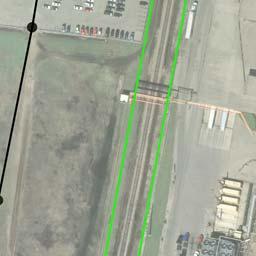
11 sewer from the rest of the Station 6 service area. There is not much time to react during high flows since the Station 6 wet well level rises very rapidly. At one time the City had plans to build a pumping station adjacent to Station 6. The proposed pumping station would act to isolate the local sewers along Johns Street from the Station 6 wet well. The City elected not to build this local pumping station, in part due to the District s change in operation in 2002 when flows from Station 1 were rerouted from Station 6 to Station 2. The proposed connector line would act to greatly mitigate flooding in the Johns Street area. Exceeding the capacity at Station 6 will eventually cause an overflow into Starkweather Creek and/or Lake Monona. There is an overflow flap gate at MH that would overflow to the creek. Before the overflow elevation is reached many basements would flood in the Johns Street area, as previously mentioned. Station 10 previously had an overflow for the incoming interceptor sewer at MH10-114, near Sycamore Road. This overflow was abandoned in 2010 as part of the new relief and replacement sewers that were installed from Station 10 to Lien Road. Route Alternatives and Cost A connector line could flow by gravity from Station 6 to Station 10 or via force main between the two stations. Two alternate routes for a gravity connector are shown in Appendix 7. The connector line for Alternate 1 would connect to MH and travel along the east side of Starkweather Creek to O.B. Sherry Park. The sewer would extend northeasterly across the park to Milwaukee Street, at which point it would head to the north across lands owned by the Voit Concrete Company. The sewer would travel to the south and east of the existing sand pit on the Voit site and finally extend east to MH across lands owned by the City of Madison. The total length of the route is approximately 6,300 feet, with one railroad crossing and significant dewatering expected across the wetlands owned by the City of Madison. Excavation for a gravity main in the vicinity of Milwaukee Street would be on the order of feet (see Appendix 10 for proposed invert elevations and manhole depths for both route options). Easements would be needed for much of the route for lands owned by the Voit Concrete Company and the City of Madison. The connector line for Alternate 2 would be a more direct route to Station 10 along City of Madison streets. It would connect to the wet well at Station 6 and then head to the northeast to Station 10 along Harding Street, Richard Street, and Schenk Street. The total length of this option is approximately 5,600 feet, so it is significantly shorter than Alternate 1. The depths of the sewer are generally feet along the entire length. Due to excavation on City streets the unit price of construction is expected to be considerably more than that for Alternate 1 due to additional factors such as traffic, other utilities, and pavement removal and replacement. Land acquisition for this option should be minimal. It is likely that Alternate 1 would be the preferred route based on costs. Although certain segments involve deep construction and would require dewatering, there is little impact to City streets and interferences with other utilities should be minimal. Using a rough estimation of $800 per lineal foot for installation of a 48 gravity sewer, the connector line is estimated to cost $5.0 million. 9
12 Flowrates Average daily and peak hourly flowrates at both stations for existing and future conditions are shown in Table 3. The carrying capacity of the connector line should be able to convey, at a minimum, the average daily flow through the year Table 3 - Stations 6 and 10 Flows Pumping Station No. Average Daily Flow (mgd) Year 2009 Year 2030 Peak Hourly Flow (mgd) Average Daily Flow (mgd) Peak Hourly Flow (mgd) Note: Average flows for 2009 are taken from MMSD pumping records. Average flows for 2030 are projected per CARPC s MMSD Collection System Evaluation. All peak flows are derived from Madison Design Curve. The design of a connector line should also consider the operating parameters outlined in Table 4 for each station. Table 4 - Stations 6 and 10 Design Parameters Conditions PS 6 PS 10 High Water Alarm Overflow Elev N/A Flooding Elev Manhole Inverts -8.9 at (10-104) & (10-102A) Large Pump Start Flooding elevations listed above are critical for the connector line design. The maximum head allowed on the connector line would be at an elevation of 6.0 at Station 6 and +2.0 at Station 10. It would be advantageous for the connector line to have enough capacity to convey both average daily and peak hourly flowrates for future conditions, although the conveyance of peak flowrates may not be attainable. A 48 connector line could convey the majority of CARPC s projected peak flows in 2030 between the stations (see Appendices 8 and 9). The capacity of this diversion line and the average daily and peak hourly flowrates for 2030 are shown in Table 5. 10
13 Table 5 - Connector Capacities for Stations 6 and 10 Pumping Station No. Average Daily Flow (mgd) Year 2030 Peak Hourly Flow (mgd) Diversion from PS 6 to PS 10 Capacity in Proposed 48 Diversion Section (mgd) Diversion from PS 10 to PS Note: Average flows for 2030 are projected per CARPC s MMSD Collection System Evaluation. All peak flows are derived from Madison Design Curve. There is little difference in elevation between flooding in the PS6 service areas (Elev = -6.0) and the elevation at which the pumps at PS 10 typically turn on (Elev = -7.50). As a result, there is minimal capacity in the diversion line from PS6 to PS10 under normal operating conditions. Approximately 5.6 mgd of flow could be transferred from Station 6 to Station 10 in an emergency. This amount of flow is greater than the average daily flow to PS6, but slightly less than the peak hourly flowrate at PS6 for 2030 projections. With regard to the PS10 to PS6 diversion, it should be noted that the firm and maximum pumping capacity of PS6 is 24.2 MGD. Thus, Station 6 would not be able to handle the estimated diversion capacity of 25.9 MGD as shown in Table 5. Either additional capacity would need to be added at Station 6 or a smaller diversion line (42 ) could be installed. Station 4-8 Connector The 2002 Collection System Facilities Plan discussed the construction of a connector line from Station 8 forcemain to Station 4. Due to the relatively high costs involved to construct this line, another means of providing reliability for Station 4 was desired. A less expensive project involving the installation of valves to the force mains from Stations 2 and 4 was identified and completed in The Station 4 force main connects to the Station 2 force main just to the east of Station 4. Prior to the PS2 Forcemain Replacement project, a break in the PS2 forcemain in either direction from PS4 would disable both force mains. By adding a valve just north of the Station 4 connection, Station 2 can be isolated if a Station 2 force main break occurs between Station 4 and Station 2. In this case Station 4 flow can continue to be pumped to the plant during the repair of a break between these stations. Another valve just south of the Station 4 connection allows Station 4 flow to pump to Station 2 if a force main break occurs between this valve and the meter vault at the treatment plant s headworks facility. 11
14 Connecting the Stations 2 and 4 force main lines has added reliability for force main breaks but not for station problems. Hauling Station 4 flow to the plant with Metrogro semi trucks or using a generator are the current contingency plans for any Station 4 outage. Given the additional flexibility provided by the valve installation project in 2000, no additional connector lines are proposed for Station 4 at this time. Station 15-5 and Connectors Incoming gravity flow to Station 15 can be diverted to Station 5 through MH05-102A located near Station 15. The West Interceptor flow was originally conveyed by Station 5. This flow upstream of MH05-102A was diverted to Station 15 in 1974 when the station was put in service. This manhole has a slide gate with a small hole in the middle of the gate to allow flow to continue down the West Interceptor. The hole is now above the normal water elevation so that flow through the hole occurs only during high flow situations. Due to corrosion problems in the West Interceptor downstream of Station 15, consideration was given to abandoning a stretch of this system along Lake Mendota between Marshall Park and Baker Avenue. However, abandonment of this portion of the system would require the construction of new local sewers to maintain service to properties currently served directly by the West Interceptor. In addition, abandonment of the West Interceptor in this area would eliminate a valuable relief option for Station 15. The District intends to rehabilitate the corroded portions of the West Interceptor with a cured-in-place lining in Station 15 was out of service on June 18, 1998 for almost 3 hours. Flow ran over the slide gate in MH05-102A without causing any known backup problems. Capacity of the 14 and 16 West Interceptor segments downstream of this manhole are 2.1 MGD and 2.9 MGD, respectively. These segment capacities are estimates based upon lining of the 1931 cast iron pipe. Station 15 average daily flow in 2009 was 1.36 MGD, with the 2030 estimated average daily flow increasing to 1.83 MGD. Thus, this portion of the West Interceptor can be relied upon for diverting Station 15 s average daily flows until 2030, but the line capacity is likely exceeded for peak flows. Other options available during Station 15 outages or force main problems include using a generator to run the station or pumping flow to Station 16 through a diversion force main. The diversion force main relieves the West Interceptor system and Station 8 and could be used during specific force main repairs. Force main problems downstream of MH (near Allen Boulevard and University Avenue) could be repaired while diverting flow to Station 16. Station 16-5 Connector Incoming gravity flow to Station 16 can be diverted to Station 5 by overflowing the dam in MH05-230, located across Gammon Road from Station 16. This would also reduce flows to Stations 12 and 11. Station 16 average daily flow in 2009 (without Station 15 flow included) is 1.71 MGD, with an estimated increase to 3.05 MGD by Minimum capacity in the West 12
15 Interceptor downstream of MH is 1.39 MGD. Therefore, there is insufficient capacity in the West Interceptor diversion to handle all of the existing Station 16 flow. Station 16 and its force main are 30 years old. The likelihood of failures for these facilities is less than in other portions of the collection system. Station controls have been a concern but were recently upgraded. Additional diversion capabilities for this station are not required at this time. Station 13 Flow Diversion to Station 1 Background and Purpose Currently there is little redundancy in the District s Eastside collection system. Other than Station 1, no pumping station in this part of the system has the ability to back up or relieve another station in the event of a station or force main outage. In an effort to provide more redundancy, connector lines between Stations 6 and 10 and between Stations 7 and 18 have been proposed and discussed in the Collection System Facilities Plan. Another location where redundancy could be implemented in the Eastside collection system is between Stations 13 and 1. Prior to 1971, flows from the Warner Park area in the City of Madison were routed to Station 1 on N. First Street. Flow was conveyed along Packers Avenue to Oscar Mayer through City of Madison sewers that were originally constructed in the 1940 s to serve the Dane County sanitarium on Northport Drive. A relief sewer was constructed along this route in the 1960 s to provide additional capacity. MMSD sewers conveyed the flow from the end of the City s sewers at Oscar Mayer to Station 1. In the late 1960 s and early 1970 s the District constructed Stations 13 and 14 and extended the Northeast Interceptor to the villages of DeForest and Waunakee. Due to capacity constraints in the Station 1 service area and with the Warner Park area continuing to grow, the City elected to build a new diversion sewer (Truax Interceptor) to connect the Warner Park lands to the Northeast Interceptor and Station 13. This diversion sewer begins at the intersection of Packers Avenue and International Lane and currently directs all flow from the Warner Park area to Station 13 via slide gates. Flowrates at Pumping Stations The District has made significant improvements to conveyance and pumping capacity in the Station 1 service area since the 1960 s and 1970 s. Adequate capacity is now available such that flows from the City of Madison s Fremont Pumping Station and the County sanitarium sewershed could be redirected to Station 1, if desired. The lands generating the flows to be diverted comprise approximately 2,150 acres and are shown as subbasins 13-A, 13-D, and 13-E on CARPC s subbasin delineation map in Appendix 11 (Figure 3-34). Using CARPC s 2030 TAZ flow estimates, an average daily flow of 1.23 MGD and a peak hourly flow of 3.06 MGD could be diverted by gravity from Station 13 to Station 1. 13
16 Benefits of Flow Diversion There are several benefits to diverting a portion of the Station 13 flow to Station 1. Most importantly, the diversion would allow for redundancy and flexibility in this portion of the collection system. This is an important consideration in that the Station 13 service area is generally a low-lying area with a history of infiltration and inflow concerns. The flow diversion would also postpone the need for firm pumping capacity improvements at Station 13 and in the interceptor downstream of PS13 by at least ten years. Table 6 shows the major facility improvements affected by the PS13 flow diversion and the required timing of these improvements. CARPC s flow projections using both Traffic Analysis Zone (TAZ) data and Uncertainty Factor (UF) data were used in determining the timing of the improvements. Table 6 - Summary of Improvements for PS 13 Flow Diversion Year Improvement is Required No Diversion With Diversion Improvement TAZ Flows UF Flows TAZ Flows UF Flows Increase PS 13 Firm Capacity Relief for NEI Truax Extension (MH to MH10-121) Construct interceptor to connect PS 13 service area to PS 1 Not needed Not needed Prior to flow diversion Prior to flow diversion It is not anticipated that any capacity improvements would be needed at downstream Stations 1 and 2 if flow were diverted from the Station 13 service area. Both of these stations were recently rehabilitated and have sufficient firm capacity to accept the diverted flow. The effect of the diversion on flowrates at all of the downstream pumping stations is shown in Appendix 12 for various development scenarios. Diverting flow from the PS13 service area would result in a small increase in overall pumping costs. Currently flow from the PS13 subbasins is pumped at three stations (13, 10, and 7). With the diversion the flow would be pumped at two stations (1 and 2). As can be seen in Table 7, the total unit cost to pump flow through Stations 13, 10 and 7 and the treatment plant s effluent force main is approximately $110/MGal. The costs for pumping through Stations 1 and 2 and the effluent force main are approximately $118/MGal. Thus, there is a small increase in pumping costs associated with diverting the flow to Station 1. 14
17 250 Table 7 MMSD Annual Pumping Costs Per Station (2009) Effluent and Pumping Station Costs 159 $/MGal Pumped Pumping Station Number Infrastructure and Costs Much of the infrastructure to convey the diverted flow is already in place and has available capacity. In 2002 the District completed its upgrade of the North Basin Interceptor from Station 1 to the intersection of Pennsylvania Avenue and Commercial Avenue. This new 36 sewer has adequate capacity to accommodate the diverted flow. Sufficient capacity should also be available in the City s sewer system along Packers Avenue from International Lane to a point approximately 650 feet south of Aberg Avenue. At this point the City s sewers decrease in size and additional capacity would have to provided to the terminus of the North Basin Interceptor at Pennsylvania Avenue and Commercial Avenue. The District has abandoned facilities along the Packers Avenue and Commercial Avenue corridor. At one time the Burke Outfall and a 30 cast iron sewer connected to the City s sewers south of Aberg Avenue and conveyed flow all the way to Station 1. These facilities were originally constructed in 1911 and 1912 to convey flow to and from the Burke Treatment Plant east of STH 113 and were eventually converted to gravity sewers. Due primarily to structural considerations, portions of these facilities were abandoned in the 1990 s, with the entire length abandoned fully by
18 The length of new sewer along Packers Avenue and Commercial Avenue that would be required is approximately 2,700 feet in length (see Appendix 13 for map). Assuming installation of a new 30 sewer at a unit cost of $700 per foot, the approximate project cost would be $1.9 million. A present worth analysis was conducted to compare the life cycle costs over a 40-year period for operation under the existing conditions as opposed to diverting flow as previously discussed (see Appendix 14). The present worth cost to operate under existing conditions is approximately $8.6 million, while the present worth costs to divert the flow is approximately $8.1 million. Thus, it should be economically feasible to construct this project and operate as outlined above. A more thorough cost analysis should be conducted to evaluate this project as capacity needs at PS13 and in the NEI (Truax Extension) become more imminent. It is assumed that installation of a replacement sewer could proceed along the Packers Avenue Service Road and Commercial Avenue adjacent to the abandoned Burke Outfall. This assumption requires further investigation as a portion of the Burke Outfall was abandoned in 1995 at the City s request to allow installation of a new storm sewer for Oscar Mayer. Conflicts with this storm sewer and other utilities may pose a problem for installation of a new replacement sewer in this corridor. Conclusions Little flexibility and redundancy is currently available in the District s Eastside collection system, especially in the upper reaches of the system (Stations 13 and 14). The ability to divert flow from a portion of the Station 13 service area to Station 1 would provide options during high-flow events or extended station or force main outages downstream. While this diversion would address only a fraction of the total flow to Station 13, it may prove especially useful in very intense and localized storms, such as the storms that caused Stations 13 and 14 to be bypassed for a short time in June of At present there is not a pressing need to implement this diversion. The project is expected to postpone the need to provide capacity relief in the NEI (Truax Extension) and additional firm pumping capacity at Station 13 by an additional ten years, although PS13 will likely require a major rehabilitation for equipment prior to The effect on other system improvements due to this diversion is negligible. Nevertheless, the cost to implement this project is relatively affordable and should be considered a long-term goal. The City s sewers along the Packers Avenue Service Road are years old and are approaching the end of their service lives. When the City elects to replace or rehabilitate these sewers the District should consult with the City and investigate cost-sharing alternatives to provide additional capacity in this corridor. 16
19 Summary and Recommendations This memo reviewed the status of existing station connector lines and identified potential improvement projects and potential new projects. It is recommended that the following projects be evaluated during the overall facility plan project prioritizing procedure. 1. Replace the Southwest Interceptor from MH (Haywood Drive and Mills Street) to MH (Haywood Drive and West Shore Drive) with a 36 line to serve as a gravity connector between Stations 2 and 8. Approximate cost is estimated at $1 million. 2. Investigate a possible new 48 connector between Stations 6 and 10 at an approximate cost of $5.0 million. 3. As a long-term consideration, explore opportunities to divert flow on a daily or event basis from the Station 13 service area to Station 1. District staff should consult with the City of Madison on cost-sharing alternatives to upgrade sewer capacity along the Packers Avenue Service Road and Commercial Avenue between Packers Avenue and Pennsylvania Avenue. 17
20 Appendix 1. Emergency diversion from PS 2 to PS 8 Existing conditions 2. Emergency diversion from PS 2 to PS 8 Proposed conditions 3. Emergency diversion from PS 8 to PS 2 Existing conditions 4. Emergency diversion from PS 8 to PS 2 Proposed conditions PS 2 FM broke elbow near Sayle Street PS 8 power outage 7. Alternate route map for Stations 6-10 connector line 8. Emergency diversion from PS 6 to PS Emergency diversion from PS 10 to PS PS 6-10 Connector Characteristics 11. Map of Pump Station 13 service area 12. Pump Station 13 flow diversion Effects on downstream pump stations 13. Pump Station 13 Diversion Sewer Year Present Worth Cost Analysis for Pump Station 13 Diversion 18
21 APPENDIX 1 EMERGENCY DIVERSION FROM PS 2 TO PS 8 Existing Conditions FIND: Wet well elevations at Pump Station No. 2 for various rates of "backflow" from PS 2 to PS 8. I. PHYSICAL CHARACTERISICS OF DIVERSION (EXISTING) Haywood Drive Section Shore Drive Section Length, L, of 24" overflow (ft) = 1,438 Length, L, of 36" overflow (ft) = 1,770 Pipe diameter, D (ft) = 1.92 Pipe diameter, D (ft) = 3.00 Pipe area, A (ft 2 ) = Pipe area, A (ft 2 ) = Hydraulic radius, R (ft) = 0.48 Hydraulic radius, R (ft) = 0.75 Manning's n = Manning's n = Water surface elevation at discharge (MH08 106) = 3.85 (assumes 48" Randall Relief flowing full) II. CALCULATE FLOW BY MANNING'S EQUATION (EXISTING) Q = (1.49/n) * A*R 2/3 *S 1/2 H = ((Q*n)/(1.49*A*R 2/3 )) 2 * L Head Loss, H, Water Surface Head Loss, H, Water Surface Diversion Diversion in Haywood Elevation at in Shore Elevation at Flow, Q Flow, Q Drive Section MH Drive Section PS 2 (mgd) (cfs) (ft) (ft) (ft) (ft) MH MH HAYWOOD DRIVE SECTION SHORE DRIVE SECTION mgd ELEV = IE 1,438 ft of 24" CI* IE 1,770 ft of 36" PVC PS #2 WET WELL " IE = IE IE * Note: Flow in 24" CI section calculated as equivalent 23" diameter due to presence of mineral deposits. EMERGENCY DIVERSION PS 2 TO PS 8 Existing Conditions 1 of 1
22 APPENDIX 2 EMERGENCY DIVERSION FROM PS 2 TO PS 8 Proposed Conditions FIND: Wet well elevations at Pump Station No. 2 for various rates of "backflow" from PS 2 to PS 8. I. PHYSICAL CHARACTERISICS OF DIVERSION Haywood Drive Section Shore Drive Section Length, L, of 24" overflow (ft) = 1,438 Length, L, of 36" overflow (ft) = 1,770 Pipe diameter, D (ft) = 3.00 Pipe diameter, D (ft) = 3.00 Pipe area, A (ft 2 ) = Pipe area, A (ft 2 ) = Hydraulic radius, R (ft) = 0.75 Hydraulic radius, R (ft) = 0.75 Manning's n = Manning's n = Water surface elevation at discharge (MH08 106) = 3.85 (assumes 48" Randall Relief flowing full) II. CALCULATE FLOW BY MANNING'S EQUATION Q = (1.49/n) * A*R 2/3 *S 1/2 H = ((Q*n)/(1.49*A*R 2/3 )) 2 * L Head Loss, H, Water Surface Head Loss, H, Water Surface Diversion Diversion in Haywood Elevation at in Shore Elevation at Flow, Q Flow, Q Drive Section MH Drive Section PS 2 (mgd) (cfs) (ft) (ft) (ft) (ft) MH MH HAYWOOD DRIVE SECTION SHORE DRIVE SECTION mgd ELEV = IE 1,438 ft of 36" PVC 1,770 ft of 36" PVC PS #2 WET WELL IE 15" IE = IE EMERGENCY DIVERSION PS 2 TO PS 8 Proposed Conditions Haywood Drive Replacement Sewer 1 of 1
23 APPENDIX 3 EMERGENCY DIVERSION FROM PS 8 TO PS 2 Existing Conditions FIND: Wet well elevations at Pump Station No. 8 for various rates of "backflow" from PS 8 to PS 2 I. PHYSICAL CHARACTERISICS OF DIVERSION Haywood Drive Section Wingra Drive Section Length, L, of 24" overflow (ft) = 1,438 Length, L, of 48" overflow (ft) = 3,179 Pipe diameter, D (ft) = 1.92 Pipe diameter, D (ft) = 4.00 Pipe area, A (ft 2 ) = Pipe area, A (ft 2 ) = Hydraulic radius, R (ft) = 0.48 Hydraulic radius, R (ft) = 1.00 Manning's n = Manning's n = Water surface elevation at discharge (MH02 606) = 5.36 (assume 36" on Shore Drive is flowing full) II. CALCULATE FLOW BY MANNING'S EQUATION Q = (1.49/n) * A*R 2/3 *S 1/2 H = ((Q*n)/(1.49*A*R 2/3 )) 2 * L Head Loss, H, Water Surface Head Loss, H, Water Surface Diversion Diversion in Haywood Elevation at in Wingra Elevation at Flow, Q Flow, Q Drive Section MH Drive Section PS 8 (mgd) (cfs) (ft) (ft) (ft) (ft) of 1
24 APPENDIX 4 EMERGENCY DIVERSION FROM PS 8 TO PS 2 Proposed Conditions FIND: Wet well elevations at Pump Station No. 8 for various rates of "backflow" from PS 8 to PS 2 I. PHYSICAL CHARACTERISICS OF DIVERSION Haywood Drive Section Wingra Drive Section Length, L, of 24" overflow (ft) = 1,438 Length, L, of 48" overflow (ft) = 3,179 Pipe diameter, D (ft) = 3.00 Pipe diameter, D (ft) = 4.00 Pipe area, A (ft 2 ) = Pipe area, A (ft 2 ) = Hydraulic radius, R (ft) = 0.75 Hydraulic radius, R (ft) = 1.00 Manning's n = Manning's n = Water surface elevation at discharge (MH02 606) = 5.36 (assume 36" on Shore Drive is flowing full) II. CALCULATE FLOW BY MANNING'S EQUATION Q = (1.49/n) * A*R 2/3 *S 1/2 H = ((Q*n)/(1.49*A*R 2/3 )) 2 * L Head Loss, H, Water Surface Head Loss, H, Water Surface Diversion Diversion in Haywood Elevation at in Wingra Elevation at Flow, Q Flow, Q Drive Section MH Drive Section PS 8 (mgd) (cfs) (ft) (ft) (ft) (ft) of 1
25
26
27
28
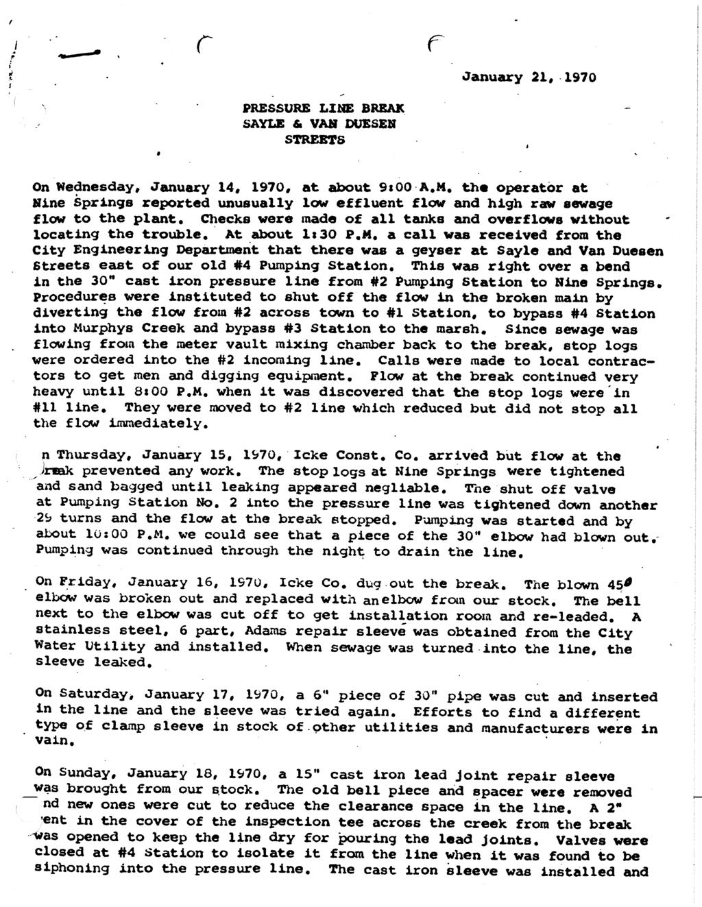
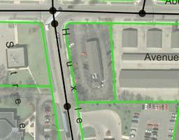
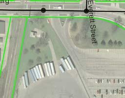
29 Appendix 7: Alternate Route Map for Stations 6-10 Connector Line Appendix 7: Alternate Route Map for Stations 6-10 Connector Line Legend Legend Alternative 1 Route Alternative 1 Route Ex. Force Main Pump Station Alternative 2 2 Route Ex. Force Ex. Gravity Main Main 0 Feet 500 Pump Station Ex. Gravity Main Feet PS 10 PS 10 Regas Road Milwaukee Street Schenk Street Harding Street Dawes Street USH 51 Richard Street Richard Street Atwood Avenue PS 6
30 APPENDIX 8 EMERGENCY DIVERSION FROM PS 6 TO PS 10 Proposed Conditions FIND: Wet well elevations at Pump Station No. 6 for various rates of "backflow" from PS 6 to PS 10. I. PHYSICAL CHARACTERISICS OF DIVERSION Length, L, of 42" overflow (ft) = 1,043 Length, L, of 48" overflow (ft) = 6,300 Pipe diameter, D (ft) = 3.50 Pipe diameter, D (ft) = 4.00 Pipe area, A (ft 2 ) = Pipe area, A (ft 2 ) = Hydraulic radius, R (ft) = 0.88 Hydraulic radius, R (ft) = 1.00 Manning's n = Manning's n = Assumed water surface elevation at discharge (MH10 102A) = 8.00 II. CALCULATE FLOW BY MANNING'S EQUATION Q = (1.49/n) * A*R 2/3 *S 1/2 H = ((Q*n)/(1.49*A*R 2/3 )) 2 * L Head Loss, H, Head Loss, H, Water Surface Diversion Diversion in 42" Diversionin 48" Diversion Elevation at Flow, Q Flow, Q Section Section PS 6 (mgd) (cfs) (ft) (ft) (ft) Elevation (ft) 1 of 1
31 APPENDIX 9 EMERGENCY DIVERSION FROM PS 10 TO PS 6 Proposed Conditions FIND: Wet well elevations at Pump Station No. 10 for various rates of "backflow" from PS 10 to PS 6. I. PHYSICAL CHARACTERISICS OF DIVERSION Length, L, of 48" overflow (ft) = 1,067 Length, L, of 48" overflow (ft) = 6,300 Pipe diameter, D (ft) = 4.00 Pipe diameter, D (ft) = 4.00 Pipe area, A (ft 2 ) = Pipe area, A (ft 2 ) = Hydraulic radius, R (ft) = 1.00 Hydraulic radius, R (ft) = 1.00 Manning's n = Manning's n = Assumed water surface elevation at discharge (MH06 102) = 5.40 II. CALCULATE FLOW BY MANNING'S EQUATION Q = (1.49/n) * A*R 2/3 *S 1/2 H = ((Q*n)/(1.49*A*R 2/3 )) 2 * L Head Loss, H, Head Loss, H, Water Surface Diversion Diversion in 48" Diversionin 48" Diversion Elevation at Flow, Q Flow, Q Section Section PS 10 (mgd) (cfs) (ft) (ft) (ft) of 1
32 APPENDIX 10 PS 6 10 CONNECTOR CHARACTERISTICS Proposed Conditions Alternate 1 Pipe Manhole Manhole From To Upstream Downstream Length Rim Depth Manhole Manhole EI EI (ft) (ft) (ft) MH Div Div1 Div Div2 Div Div3 Div Div4 Div Div5 Div Div6 Div Div7 Div Div8 Div Div9 Div Div10 Div Div11 Div Div12 Div Div13 Div Div14 MH10 102A TOTAL FOOTAGE = 6,267 GRADE = % Page 1 of 2
33 Proposed Conditions Alternate 2 Pipe Manhole Manhole From To Upstream Downstream Length Rim Depth Manhole Manhole EI EI (ft) (ft) (ft) PS 6 Div Div1 Div Div2 Div Div3 Div Div4 Div Div5 Div Div6 Div Div7 Div Div8 Div Div9 Div Div10 PS TOTAL FOOTAGE = 5,449 GRADE = % Page 2 of 2


34 10/23/2008 I 39 CV I MMSD Estorf Property Future Boundary City of Sun Prairie 14-J to 13-H H Hoepker Road Yahara River 13-F CV M F Hanson Road 10-A to 13-H 13-G 13-H PS E Lake Mendota Troy Drive 13-D N Sherman Avenue 13-A CV International Lane 13-B 13-C Anderson Street E Washington Avenue Sub-Basins in 2000 Potential by 2030 Potential by 2060 DNR Wetlands PUMPING STATION 13 SUB-BASINS MADISON METROPOLITAN SEWERAGE DISTRICT COLLECTION SYSTEM EVALUATION Miles FIGURE 3-34
35 APPENDIX 12 PUMP STATION 13 FLOW DIVERSION EFFEFCTS ON DOWNSTREAM PUMP STATIONS Average Daily Flows at Pump Stations No Diversion With Diversion Firm 2030 TAZ 2030 UF TAZ 2030 UF 2060 Pumping Average Daily Average Daily Average Daily Average Daily Average Daily Average Daily Pumping Capacity Flow Flow Flow Flow Flow Flow Station (mgd) (mgd) (mgd) (mgd) (mgd) (mgd) (mgd) Peak Hourly Flows at Pump Stations No Diversion With Diversion Firm 2030 TAZ 2030 UF TAZ 2030 UF 2060 Pumping Peak Hourly Peak Hourly Peak Hourly Peak Hourly Peak Hourly Peak Hourly Pumping Capacity Flow Flow Flow Flow Flow Flow Station (mgd) (mgd) (mgd) (mgd) (mgd) (mgd) (mgd) Peak Hourly Flow Exceeds Firm Capacity 1 of 1


36 Packers Avenue City of Madison Sanitarium Sewer Aberg Avenue Oscar Mayer 30" Diversion Sewer (~2700 FT) Existing MMSD North Basin Interceptor Madison Metropolitan Sewerage District Appendix 13- Pump Station 13 Diversion Sewer Prepared by: JP Scale: 1" = 300' Date: 5/14/10
37 APPENDIX Year Present Worth Cost Analysis for Pump Station 13 Diversion MAJOR CAPITAL COSTS FOR PS 13 DIVERSION Unit Total No. Description Footnote Cost Units Quantity Cost 1 PS13 to PS1 Connector Sewer (1) $700 L.F. 2,700 $1,890,000 2 Upgrade PS13 Firm Capacity (2) $150,000 LUMP SUM 1 $150,000 3 NEI (Truax Extension) Relief Sewer (3) $850 L.F. 10,000 $8,500,000 Notes: (1). MMSD 50 Year Master Plan (TM3) cites unit cost of $500 per foot for 30" gravity sewer. Unit cost for PS13 diversion sewer adjusted to account for utility congestion in construction corridor and for construction of new diversion structures at International Lane and Packers Avenue. (2). Includes cost for one centrifugal pump and drive, analogous to existing Pump 13C, in empty slot at PS13. No other rehabilitation work is included in estimate. Earth Tech's Design Report for PS 13 & 14 Firm Capacity Improvements (2007) suggests that future firm capacity of 30.7 MGD can be achieved by providing a new pump similar to capacity of existing Pump 13C. (3). Project limits are MH to MH Estimated construction cost is based on actual unit cost of $950/ft for MMSD's NEI (PS 10 to Lien Road) project and unit cost of $800/ft as taken from TM 3 of MMSD 50 Year Master Plan. (4). All costs in 2010 dollars. Page 1 of 2
4. CONVEYANCE SYSTEM
 4. CONVEYANCE SYSTEM 4.1. Background... 1 4.2. Existing Conveyance System... 1 4.3. Current Conveyance Deficiencies for Centralized Treatment... 4 4.4. Existing Facility Condition Assessment... 5 CONVEYANCE
Chapter 8 Addressing I/I Issues and High Flows
 Chapter Outline Chapter 8 Addressing I/I Issues and High Flows This chapter is organized into the following sections: Introduction Background Estimation of Infiltration Volume Conveyance Costs Effect of
Technical Memorandum No. 1
 DISTRICT OF COLUMBIA WATER AND SEWER AUTHORITY Serving the Public Protecting the Environment Technical Memorandum No. 1 Multi-Jurisdictional Use Facilities Capital Cost Allocation DRAFT April 17, 2013
Hydraulic Modeling of Deep Tunnel Provides Cost Savings
 5 Hydraulic Modeling of Deep Tunnel Provides Cost Savings Taymour El-Hosseiny, Karen Reinhart and M. P. Cherian In 2005, the City of Columbus, Ohio submitted a plan to the Ohio Environmental Protection
Chapter 5: Conveyance Assessment 2020 Baseline Conditions
 Chapter 5: Conveyance Assessment 2020 Baseline Conditions 5.1 Introduction The performance of the conveyance system for 2020 Baseline conditions is assessed in this chapter using the hydraulic models.
Wilmette - Background
 Reducing Basement Backups through Intergovernmental Cooperation and Design-Build Presented By Michael N. Young, P.E. Brigitte Ann Berger, P.E. Wilmette - Background North Shore Suburb of Chicago 5 Square
City of Elmhurst Comprehensive Flooding Plan Task Force Meeting
 April 26, 2011 City of Elmhurst Comprehensive Flooding Plan Task Force Meeting Prepared by CBBEL RJN Group Meeting Overview Progress Report on Comprehensive Plan Sanitary Sewer System Storm Sewer System
West Bountiful City. Water System Capital Facilities Plan
 Water System Capital Facilities Plan August 2008 TABLE OF CONTENTS 1.0 Executive Summary... 1 2.0 Definition of Terms and Abbreviations... 2 3.0 Introduction... 3 3.1 Background...3 3.2 Scope of Investigation...3
Technical Memorandum - Final
 Technical Memorandum Final Water andenvironment Subject: Tuscany Meadows Offsite Sewerage Impacts Evaluation Prepared For: Patricia Chapman, DDSD Prepared by: Chris van Lienden, RMC Reviewed by: Gisa Ju,
WEF Collection Systems Conference 2017
 Davenport, Iowa 14th District Diversion Study Karol Giokas, P.E., RJN Group Tom Leabhart, P.E., Davenport, IA ABSTRACT The 14 th District sanitary sewer basin in Davenport, Iowa has high levels of inflow
SEWER SYSTEM DESIGN GUIDELINES
 SEWER SYSTEM DESIGN GUIDELINES PART 1 GENERAL 1.1 GENERAL GUIDELINES A. The following sewer system design guidelines are based on Federal, State and Local health requirements, and the Berkeley County Water
Consent Decree Appendix 1. Control Measures and Performance Criteria
 Case: 1:10-cv-02895-DCN Doc #: 2-2 Filed: 12/22/10 1 of 6. PageID #: 82 United States and State of Ohio v. Northeast Ohio Regional Sewer District Consent Decree Appendix 1 Control Measures and Performance
City of Madison: 2017 Capital Budget Capital Improvement Plan
 City of Madison: 2017 Capital Budget Capital Improvement Plan Agency: Stormwater Utility Project Summary Backyard Drainage Problems 25,000 25,000 25,000 25,000 25,000 25,000 CIPP Lining Storm Sewer 100,000
CHAPTER 6 COLLECTION SYSTEM HYDRAULIC MODEL
 CHAPTER 6 COLLECTION SYSTEM HYDRAULIC MODEL INTRODUCTION The District developed a hydraulic model of the sanitary sewer system as part the 2000 Wastewater Comprehensive Plan. The output from this model
Milwaukee Metropolitan Sewerage District Conveyance and Treatment System. MACRO made available by
 Milwaukee Metropolitan Sewerage District Conveyance and Treatment System MACRO made available by Eric Loucks,, CDM MMSD Collection System Operations MMSD operates an extensive system of sanitary sewers
Project Summary
 Stormwater Utility Capital Improvement Plan Project Summary 2017 2018 2019 2020 2021 2022 Backyard Drainage Problems 25,000 25,000 25,000 25,000 25,000 25,000 CIPP Lining Storm Sewer 100,000 100,000 100,000
CRYSTAL LAKE FLOODING STUDY EXECUTIVE SUMMARY
 Project #08223 CRYSTAL LAKE FLOODING STUDY EXECUTIVE SUMMARY PREPARED FOR: City of Crystal Lake 100 West Woodstock Street Crystal Lake, Illinois 60014 FEBRUARY 11, 2009 26575 W. COMMERCE DRIVE, SUITE 601,
To: From: Date: Subject: Sherwood Lakes Drainage Alternatives Analysis 1
 To: From: The City of Virginia Beach Lewis White and Rachael Johnson on behalf of WSP Date: June 6, 2017 Subject: s Drainage Alternatives Analysis This memorandum represents the summary of findings from
3.9 times the average 3.8 times the average 3.6 times the average
 ARTICLE VI DESIGN OF SANITARY SEWERS M'RSMIN. VOL.281 JA 2 4 2001 IMAGE; Section 601 Determination of the Amount of Sewage for Sanitary Sewers A. MSD Design Standards for estimating sanitary sewage flow
Feasibility Report for City of Worthington, Minnesota West Gateway Drive Area Sewer & Water Extensions November 17, 2017
 Feasibility Report for City of Worthington, Minnesota West Gateway Drive Area Sewer & Water Extensions November 17, 2017 Prepared By: Introduction The purpose of this report is to determine the feasibility
Page Intentionally Left Blank
 Page Intentionally Left Blank Julie Avenue and Hoeschler Drive Lift Stations Evaluation City of Sparta TABLE OF CONTENTS Page CHAPTER 1 GENERAL INFORMATION... 1 1.1 Scope of Lift Station Evaluation...
4 EXISTING FACILITIES EVALUATION
 4 EXISTING FACILITIES EVALUATION The City is served by a combination of wastewater collection, conveyance, and treatment systems. The City owns and operates the collection system that collects wastewater
Jacobi, Toombs, and Lanz, Inc.
 Area 5: Blackiston Mill Road at Dead Man's Hollow Flooding Assessment Jacobi, Toombs, and Lanz, Inc. This document summarizes an assessment of drainage and flooding concerns and provides recommendations
City of Gardiner, Maine Wastewater Committee Meeting. CSO Storage Tank & Screening Evaluation
 City of Gardiner, Maine Wastewater Committee Meeting CSO Storage Tank & Screening Evaluation December 11, 2013 Introduction - Update on field work - Flow monitoring - Survey - GIS - Borings - Assessment
VILLAGE OF ALGONQUIN 2014 WASTEWATER FACILITY PLAN UPDATE EXECUTIVE SUMMARY
 EXECUTIVE SUMMARY EXECUTIVE SUMMARY INTRODUCTION AND BACKGROUND The Village of Algonquin, located along the Fox River in McHenry County, provides wastewater collection and treatment services to the entire
APPENDIX B STANDARD CONSTRUCTION DRAWING NOTES
 APPENDIX B STANDARD CONSTRUCTION DRAWING NOTES B-1 General Notes: SACWSD Standard Construction Drawing Notes 1. No work shall begin on any water or wastewater construction project until the construction
Measure Twice, Cut Once Using Flow Monitoring Data to Re-evaluate Wet Weather Improvement Alternatives
 Measure Twice, Cut Once Using Flow Monitoring Data to Re-evaluate Wet Weather Improvement Alternatives Barbara Moranta, PE CDM Smith Multi-Million Dollar Upgrades Planned for Crooked Creek Basin Planning
CHAPTER 6. Sanitary Sewer
 CHAPTER 6 Sanitary Sewer A. Introduction All proposed developments, subdivisions, and buildings must have a properly designed and constructed sanitary sewer collection system. The system shall provide
River Valley Neighbourhoods Flood Risk Study. Cloverdale Public Consultation - May 13, 2015
 River Valley Neighbourhoods Flood Risk Study Cloverdale Public Consultation - May 13, 2015 Today s Meeting 1. Provide results of the studies done regarding drainage issues in your neighbourhood. 2. Discuss
CHAPTER 4 SYSTEM DESIGN CRITERIA
 INTRODUCTION CHAPTER 4 SYSTEM DESIGN CRITERIA Adequate design of the District s wastewater conveyance facilities requires the determination of the quantity of wastewater from contributing sources. The
Wastewater Flow Monitoring Services
 Wastewater Flow Monitoring Services For San Gabriel, CA July 13, 2015 through July 21, 2015 Revised October 9, 2015 Leaders in Sewer Flow Monitoring Services 601 N. Parkcenter Dr., Suite 209 Santa Ana,
CITY OF PANAMA CITY BEACH Utilities Administration & Engineering Offices 116 South Arnold Road Panama City Beach, FL 32413
 Page: 1 of 5 CITY OF PANAMA CITY BEACH Utilities Administration & Engineering Offices 116 South Arnold Road Panama City Beach, FL 32413 COMMERCIAL/RESIDENTIAL UTILITY PLAN COMPLETENESS CHECK LIST Updated
Sanitary Sewer. Infiltration & Inflow (I/I) Study. Presented by:
 Study. Presented by:") Sanitary Sewer Infiltration & Inflow (I/I) Study City of Beatrice, Nebraska IAWEA Collection System Specialty Conference Presented by: Brian Mulinix, P.E. March 10, 2011 Discussion Topics Definition of
Sanitary Sewer Infiltration & Inflow (I/I) Study City of Beatrice, Nebraska IAWEA Collection System Specialty Conference Presented by: Brian Mulinix, P.E. March 10, 2011 Discussion Topics Definition of
ENVIRONMENTAL ASSESSMENT
 ENVIRONMENTAL ASSESSMENT Project Identification Project Name: Elyria East Side Relief Sewer Phase 1B South (CS390337-0018), Phase 1C (CS390337-0014), Phase 1D (CS390337-0017) Applicant: The Honorable Holly
Master Plan of Storm Drainage for East Garden Grove Wintersburg Channel Tributary Area
 CITY OF ANAHEIM Master Plan of Storm Drainage for East Garden Grove Wintersburg Channel Tributary Area JANUARY 2006 VOLUME 1 Table of Contents VOLUME 1 1. Executive Summary... 1 1.1 General... 1 1.2
Design and Construction of Local Public and Private Sewers and Ancillary Facilities
 Chapter 2 Design and Construction of Local Public and Private Sewers and Ancillary Facilities Subchapter I - General 2.101 Purpose...1 2.102 Applicability...1 2.103 Electronic data...1 2.104 Effect of
Sanitation District No.1 Cost Effectively Reduces Overflows Into the Ohio River
 Sanitation District No. 1 of Northern Kentucky Sanitation District No.1 Cost Effectively Reduces Overflows Into the Ohio River Ohio WEA Collection Systems Workshop May 5, 2011 Sanitation District No. 1
SILVER SPRINGS/RIVER POLLUTION REDUCTION PROJECT IMPROVING THE WATER QUALITY OF THE SILVER SPRINGS ECOSYSTEM
 SILVER SPRINGS/RIVER POLLUTION REDUCTION PROJECT IMPROVING THE WATER QUALITY OF THE SILVER SPRINGS ECOSYSTEM Jonathan Steflik, PE JEA (Formerly Black & Veatch) Bruce Phillips, PE PLS, Tom Young, PE City
CHAPTER 8: SANITARY SEWER
 CHAPTER 8: SANITARY SEWER 8.1 EXECUTIVE SUMMARY The Metropolitan Land Planning Act (amended 1995) requires local governments to prepare comprehensive plans and submit them to the Metropolitan Council (MCES)
CHAPTER 5. COLLECTION SYSTEM ALTERNATIVES
 CHAPTER 5. COLLECTION SYSTEM ALTERNATIVES This chapter evaluates alternative wastewater collection system technologies. Each technology is described along with the relative advantages and drawbacks for
Dry Creek Flood Control Improvement Project
 Dry Creek Flood Control Improvement Project The following is a brief overview of the planned IRWM Stormwater Flood Management Grant Application from the Fresno Metropolitan Flood Control District (FMFCD)
PLANNING FOR THE FUTURE: A REGIONAL MASTER PLAN APPROACH WITH THE OPPORTUNITY TO MINIMIZE FUTURE OPERATION AND MAINTENANCE CONCERNS
 PLANNING FOR THE FUTURE: A REGIONAL MASTER PLAN APPROACH WITH THE OPPORTUNITY TO MINIMIZE FUTURE OPERATION AND MAINTENANCE CONCERNS ABSTRACT Robert Skip Notte*, PE, LEED AP, Dewberry, snotte@dewberry.com
6 Preliminary Assessment of Construction Method and Constructability Issues
 6 Preliminary Assessment of Construction Method and Constructability Issues 6.1 Construction Approach Appendix C includes conceptual designs of the alternatives discussed below. Generally, the conceptual
EAST VALLEY WATER DISTRICT Wastewater Collection System Master Plan. Table 4-1 Capacity Evaluation d/d Criteria
 EAST VALLEY WATER DISTRICT Wastewater Collection System Master Plan 4 Capacity Analysis The capacity analysis used the calibrated dry weather and wet weather wastewater collection system model to evaluate
Sewer Modeling of Near- Term Development Technical Memorandum
 Sewer Modeling of Near- Term Development City of Reedley, CA March 8, 2018 Page Intentionally Blank The City of Reedley (City) is anticipating near-term developments to the north of the City s currently
DOWNTOWN SHALL NOT FLOOD AGAIN
 DOWNTOWN SHALL NOT FLOOD AGAIN Robert C. Steidel**, Robert Stone**, Lin Liang*, Edward J. Cronin*, Federico E. Maisch* *Greeley and Hansen LLC 2116 W Laburnum Avenue, Suite 100 Richmond, Virginia 23227
Chapter 7: Sanitary Sewer Plan. Introduction. Metropolitan Council Coordination
 Chapter 7: Sanitary Sewer Plan Introduction The 2030 Sanitary Sewer Plan was prepared for two primary reasons. The first purpose is to provide recommendations and guidance to the City of Lino Lakes by
T a b l e o f C o n t e n t s
 C i t y o f G l a d s t o n e P u b l i c W o r k s D e s i g n S t a n d a r d s T a b l e o f C o n t e n t s SECTION THREE SANITARY SEWER REQUIREMENTS... 1 3.0000 SANITARY SEWERS... 1 3.0010 General
Section 3 Modeling and Capacity Analysis
 Section 3 Modeling and Capacity Analysis The capacity of the existing DSRSD wastewater collection system and the future capacity requirements of the system were determined through hydraulic modeling. This
Chapter 3 Previous Studies
 Chapter 3 Previous Studies The Vista Grande stormwater conveyance system and watershed area has been evaluated in a number of reports and studies for the CCSF, the Daly City and San Mateo County over the
Contact the Jurisdictional Engineer for materials allowed by each jurisdiction.
 Design Manual Chapter 3 - Sanitary Sewers 3C - Facility Design 3C-1 Facility Design A. Capacity of Pipe Pipe sizes 15 inches and smaller should carry the peak flow at a depth of no more than 0.67 of the
When confronted with increasing peaking. Managing the deluge
 Located on more than 121 ha (300 ac) of land, the Trinity River Authority (Dallas) Central Regional Wastewater water resource recovery facility is an advanced secondary treatment facility and a winner
Chapter 8-Sanitary Sewer
 Chapter -Sanitary Sewer Executive Summary Background The Metropolitan Land Planning Act (amended 1995) requires local governments to prepare comprehensive plans and submit them to the Metropolitan Council
Outfall at Lagoon between Lake of the Isles and Lake Calhoun
 Outfall at Lagoon between Lake of the Isles and Lake Calhoun Prepared for City of Minneapolis April 17, 2013 4700 West 77 th Street Minneapolis, MN 55435-4803 Phone: (952) 832-2600 Fax: (952) 832-2601
Introduction to Storm Sewer Design
 A SunCam online continuing education course Introduction to Storm Sewer Design by David F. Carter Introduction Storm sewer systems are vital in collection and conveyance of stormwater from the upstream
Two-Phase Project Adds Capacity, Reliability, and Redundancy to 80-year-old Pump Station in Saint Paul
 Two-Phase Project Adds Capacity, Reliability, and Redundancy to 80-year-old Pump Station in Saint Paul Project Overview Minnesota s state capital, Saint Paul, is built around the Mississippi and Minnesota
DRAINAGE STUDY PHASE 2 REPORT HORRY COUNTY STORMWATER DEPARTMENT HIGHWAY 9 & 57 HORRY COUNTY, SC PREPARED FOR: APRIL 07, 2016 J
 DRAINAGE STUDY PHASE 2 REPORT FOR: HIGHWAY 9 & 57 HORRY COUNTY, SC PREPARED FOR: HORRY COUNTY STORMWATER DEPARTMENT APRIL 07, 2016 Prepared by: Savannah, GA Charleston, SC Myrtle Beach, SC Brunswick, GA
EXECUTIVE SUMMARY ES.1 INTRODUCTION
 ES.1 INTRODUCTION The purpose of this Wastewater Collection System Master Plan (Master Plan) is to provide the City of Lake Oswego (City) a plan for management and operation of their wastewater collection
City of Logan Sanitary Sewer Design Standards
 City of Logan Sanitary Sewer Design Standards 2011 http://www.loganutah.org/public_works/engineering/stdsspecsdesign.cfm Table of Contents PART 1. CITY OF LOGAN SANITARY SEWER SYSTEM DESIGN STANDARDS FOR
Appendix J Effluent Pump Station
 Appendix J Effluent Pump Station TECHNICAL MEMORANDUM Salmon Creek Treatment Plant Effluent Pump Station Hydraulics and Phasing Analysis for the Phase 5A Project Columbia River Outfall and Effluent Pipeline
Wastewater Master Facility Report. (Project Name) (Project Basin Location)
 (Project Basin Location)") Wastewater Master Facility Report For (Project Name) (Project Basin Location) The Wastewater Master Facility Report for (Project name) dated (Date); located in the (Basin Name) Basin has been completed
Wastewater Master Facility Report For (Project Name) (Project Basin Location) The Wastewater Master Facility Report for (Project name) dated (Date); located in the (Basin Name) Basin has been completed
Maximizing Your Investment
 Maximizing Your Investment City of Lorain Collection System Optimization Eliminates SSOs Ohio Water Environment Association June 24, 2015 Mary Garza City of Lorain Laura McGinnis, P.E. ARCADIS Tim Ruggaber,
UNIVERSITY OF OREGON NORTH CAMPUS CONDITIONAL USE PERMIT PROJECT Draft Conditional Use Permit Stormwater, Sanitary Sewer, and Water Analysis Report
 UNIVERSITY OF OREGON NORTH CAMPUS CONDITIONAL USE PERMIT PROJECT Draft Conditional Use Permit Stormwater, Sanitary Sewer, and Water Analysis Report Prepared for: Cameron McCarthy Landscape Architects LLP
CHAPTER SEVEN: UTILITIES
 CHAPTER SEVEN: UTILITIES 7.1 Introduction The Water Works Board of the City of Auburn (AWWB) is the primary potable water service provider for the City of Auburn (City) and Auburn University. There are
Section 7 Design Criteria Irrigation and Drainage Facilities
 Section 7 Design Criteria Irrigation and Drainage Facilities 7.1 Background The Irrigation and Drainage system is comprised of the Coachella Branch of the All-American Canal (Coachella Canal), Protective
LOWER SWEETWATER CREEK
 LOWER SWEETWATER CREEK STORMWATER MANAGEMENT MASTER PLAN Prepared for the Hillsborough County Board of County Commissioners By Public Works Department/Engineering Division Stormwater Management Section
Bloomingdale Neighborhood Flooding Mitigation Washington, DC
 District of Columbia Water and Sewer Authority George S. Hawkins, General Manager Briefing on: Bloomingdale Neighborhood Flooding Mitigation Washington, DC Briefing for: Federal Water Quality Association
Wastewater Collection System
 WASTEWATER COLLECTION SYSTEM CE 370 1 Wastewater Collection System The function of the collection system is to collect the wastewater from residential, commercial, and industrial areas within the service
COON CREEK WATERSHED DISTRICT PERMIT REVIEW. Spring Lake Park Schools Westwood Middle School st Avenue NE, Spring Lake Park, MN 55432
 PAN 16-112, Westwood Middle School, Page 1 of 6 COON CREEK WATERSHED DISTRICT PERMIT REVIEW MEETING DATE: August 22, 2016 AGENDA NUMBER: 10 FILE NUMBER: 16-112 ITEM: Westwood Middle School RECOMMENDATION:
Permit for Construction of an Extension to a JEA Drinking Water Distribution System and/or JEA Wastewater Collection/Transmission System
 Permit for Construction of an Extension to a JEA Drinking Water Distribution System and/or JEA Wastewater Collection/Transmission System INSTRUCTIONS: This form shall be completed and submitted (in duplicate)
Chapter 1: Introduction
 Chapter 1: Introduction 1.1 Purpose The purpose of this chapter is to describe the contents of the Conveyance Report, which is a component of the Milwaukee Metropolitan Sewerage District (MMSD) 2020 Facilities
WASTEWATER TREATMENT PLANT AND DALE AVENUE PUMP STATION WET WEATHER CAPACITY ANALYSIS AND ALTERNATIVES EVALUATION
 WASTEWATER TREATMENT PLANT AND DALE AVENUE PUMP STATION WET WEATHER CAPACITY ANALYSIS AND ALTERNATIVES EVALUATION Prepared for City of San M ateo, California July 7, 2009 WASTEWATER TREATMENT PLANT AND
SECTION 2 - DESIGN STANDARDS FOR GRAVITY SANITARY SEWERS
 SECTION 2 - DESIGN STANDARDS FOR GRAVITY SANITARY SEWERS 2.1. General Requirements Sanitary sewers are to be provided solely for the removal of sanitary waste. Under no circumstances shall any roof drains,
Somerset Raritan Valley Sewerage Authority SSO Abatement and Storm Control Treatment Facility
 Somerset Raritan Valley Sewerage Authority SSO Abatement and Storm Control Treatment Facility Michael Sanders, P.E., Kleinfelder Collection Systems Specialty Conference NEWEA September 12, 2016 Presentation
APPENDIX F: DRAINAGE AND STORMWATER MANAGEMENT
 APPENDIX F: DRAINAGE AND STORMWATER MANAGEMENT Downtown Ottawa Transit Tunnel: Tunney s Pasture to Blair Station via a Downtown LRT Tunnel Prepared for: City of Ottawa 110 Laurier Avenue West Ottawa, ON
TOWN OF MOUNT PLEASANT WESTCHESTER COUNTY, NEW YORK
 TOWN OF MOUNT PLEASANT WESTCHESTER COUNTY, NEW YORK COST EVALUATION FOR ROLLING HILLS AREA WATER MAIN EXTENSION PROFESSIONAL CONSULTING, LLC. Octagon 10, Office Center 1719 Route 10, Suite 225 Parsippany,
Public Information Centre No. 1
 Public Information Centre No. 1 City of Timmins Schedule B Class Environmental Assessment for the WHITNEY TISDALE SANITARY SYSTEM UPGRADES Welcome Please Sign In Class EA Process & Public Consultation
Town of New Castle, New Hampshire Sewer Infrastructure Evaluation
 Town of New Castle, New Hampshire Sewer Infrastructure Evaluation March 2016 EXECUTIVE SUMMARY The Town of New Castle (Town) is working collaboratively with the City of Portsmouth (City) to consider options
CHAPTER 17: STORM SEWER STANDARDS Introduction Administration Standards 17.1
 CHAPTER 17: STORM SEWER STANDARDS 17.00 Introduction 17.01 Administration 17.02 Standards 17.1 17.00 INTRODUCTION The purpose of this chapter is to provide guidance for the design and construction of storm
Regional Hydraulic Model Plan
 APPENDIX 3 Regional Hydraulic Model Plan November 17, 2008 Contents Section 1 Introduction Section 2 Model Objectives and Capabilities 2.1 Model Software Capabilities... 2-1 Section 3 Model Development
City of Edmonton Drainage Services Summary Notes of Cloverdale Flood Mitigation Meeting Held May 13, 2015 at Cloverdale Hall
 Presenters Miressa Fola, Project Manager, Drainage Planning Maxime Belanger, Project Manager, Sameng Inc. In attendance were approximately 40 residents. River Valley Neighbourhoods Flood Risk Study Please
Rowlett Cottonwood Transfer Sewer: 60" RCP Sanitary Sewer Rehabilitation Project. TACWA Meeting
 Rowlett Cottonwood Transfer Sewer: 60" RCP Sanitary Sewer Rehabilitation Project TACWA Meeting September 25, 2009 North Texas Municipal Water District Project Background 1. Rowlett-Cottonwood Transfer
CHAPTER 5 EXISTING FACILITIES
 CHAPTER 5 EXISTING FACILITIES INTRODUCTION The District s original wastewater collection system was constructed and brought on-line in 1970 and 1971. Additional sewer facilities have been constructed within
Appendix A Stormwater Site Plan Report Short Form
 Appendix A Stormwater Site Plan Report Short Form The Stormwater Site Plan Report Short Form may be used for projects that trigger only Minimum Requirements #1-#5. These projects typically fall within
APPENDIX B. WSSC Design Criteria for Water Distribution Systems
 a. System Requirements ) Pressure Requirements APPENDIX B WSSC Design Criteria for Water Distribution Systems a) The water distribution system shall have adequate capacity to supply domestic demand to
CHAPTER 4 DESIGN CRITERIA
 CHAPTER 4 DESIGN CRITERIA 4.1 INTRODUCTION This chapter summarizes the basic design criteria necessary to develop options and sizing estimates for the components of centralized wastewater collection systems.
Community Open House
 Mayor Kasim Reed The Department of Watershed Management & Atlanta Memorial Park Conservancy Community Open House 10/28/2016 1 AGENDA: Meet & Greet Opening Remarks & Introductions District 8 Council Member
Facilities Plan. Technical Memorandum No. TM-WW-7 Hydraulic Analysis and Effluent Pump Station
 City of St. Joseph, Missouri Hydraulic Analysis and Effluent Pump Station By Work Order No. 09-001 B&V Project 163509 May 20, 2010 Table of Contents 1.0 Executive Summary...1 2.0 Purpose of Study...2 3.0
HYDRAULIC HYDRODYNAMIC MODELING AS AN EFFECTIVE MANAGEMENT TOOL FOR LARGE COLLECTION SYSTEMS - THE L.A. STORY
 HYDRAULIC HYDRODYNAMIC MODELING AS AN EFFECTIVE MANAGEMENT TOOL FOR LARGE COLLECTION SYSTEMS - THE L.A. STORY Fernando Gonzalez, Adel Hagekhalil, Bryan Trussell, City of Los Angeles Bureau of Sanitation
Sanitary Sewer 101. Jan. 12, 2016 Keith Fisher, P.E. Director of Public Works
 Sanitary Sewer 101 Jan. 12, 2016 Keith Fisher, P.E. Director of Public Works What We Will Cover -What is Sanitary Sewer? -Components -History -What types of systems are there? -What types of materials
Tunnel Works. How we got here - Fort Wayne s Consent Decree. Tunnel Works Program Frequently Asked Questions
 City Utilities operates the largest municipally-owned wastewater collection and treatment system in Indiana. The system serves 161 square miles and includes 1,014 miles of sanitary sewer lines, 365 miles
Anacostia River Tunnel Briefing For: ANC 6B
 District of Columbia Water and Sewer Authority George S. Hawkins, General Manager Briefing On: Anacostia River Tunnel Briefing For: ANC 6B October 26, 2011 Agenda Welcome and Introductions DC Water Organization
Report. Inflow Design Flood Control System Plan Belle River Power Plant East China, Michigan. DTE Energy Company One Energy Plaza, Detroit, MI
 Report Inflow Design Flood Control System Plan Belle River Power Plant East China, Michigan DTE Energy Company One Energy Plaza, Detroit, MI October 14, 2016 NTH Project No. 62-160047-04 NTH Consultants,
2010 Utility Plan Amendment Boxelder Sanitation District
 2010 Utility Plan Amendment Boxelder Sanitation District For inclusion of the Harmony Ridge Development November 7, 2014 1612 Specht Point Rd. Ste. 105 Fort Collins, Colorado 80525-9770 p 970.484.7477
DERRY GREEN BUSINESS PARK WATER AND WASTEWATER SERVICING AREA SERVICING PLAN
 DERRY GREEN BUSINESS PARK WATER AND WASTEWATER SERVICING AREA SERVICING PLAN Submitted to: Town of Milton Regional Municipality of Halton Submitted by: AMEC Earth & Environmental 3215 North Service Road
Final - Preliminary Design Report Interstate 10 and Indian Avenue Area Sewer System. Prepared for
 Final - reliminary Design Report Interstate 10 and Indian Avenue Area Sewer System repared for Mission Springs Water District July 2012 Mission Springs Water District I-10 & Indian Area Sewer System DR
MWRA s Climate Change Strategy
 Massachusetts Water Resources Authority MWRA s Climate Change Strategy Frederick A. Laskey Executive Director June 15, 2018 Changing Precipitation Quantity and Patterns Currently, we average 104 rain events
Stormwater Erosion Control & Post-Construction Plans (Stormwater Quality Plans)
") Stormwater Erosion Control & Post-Construction Plans (Stormwater Quality Plans) Allen County Stormwater Plan Submittal Checklist The following items must be provided when applying for an Allen County Stormwater
Stormwater Erosion Control & Post-Construction Plans (Stormwater Quality Plans) Allen County Stormwater Plan Submittal Checklist The following items must be provided when applying for an Allen County Stormwater
DRAFT. Technical Memorandum. Whitney Road Drainage & Safety Enhancements Phase III Hydraulic Update. Prepared For:
 DRAFT Technical Memorandum Whitney Road Drainage & Safety Enhancements Phase III Hydraulic Update Prepared For: Pinellas County Department of Environment and Infrastructure Division of Engineering and
Surge Analysis for the Proposed OSIS Augmentation Relief Sewer Tunnel
 5 Surge Analysis for the Proposed OSIS Augmentation Relief Sewer Tunnel M. P. Cherian, Ari Pandian, Karen Ridgway and Gregory Barden The City of Columbus, Ohio, submitted a wet weather management plan