Sea Level Rise Impacts on Municipal Stormwater Systems in Hampton Roads
|
|
|
- Miles James
- 5 years ago
- Views:
Transcription


1 VIRGINIA D.C. MARYLAND CHAPTER Sea Level Rise Impacts on Municipal Stormwater Systems in Hampton Roads Presentation at the APWA Mid-Atlantic Chapter May Regional Conference Virginia Beach, Virginia May 10, 2013 John M. Keifer, Director of Public Works Richard Broad, Engineering Ops. Manager John M. White, Storm Water Engineer 1

 2")
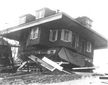
2 Flooding (1938 Rain event) Flooding (1933) 2

3 City Hall Ave
 4")
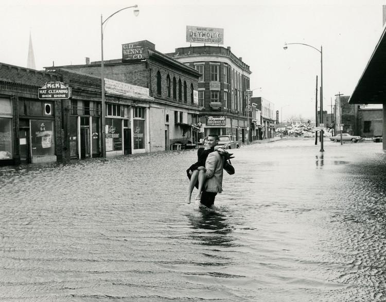
4 Flooding (1962) 4
 5")
5 Flooding (2009) 5
 6")
6 Flooding (2011) 6

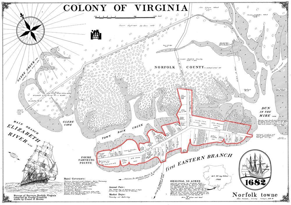
7 Colonial Town of Norfolk 7

8 Downtown Norfolk 8
9 1933 Hurricane 1936 Hurricane 1962 Ash Wednesday 1978 April Nor easter 1998 Feb. Nor easter 1999 Tropical Strom 2003 Isabel 2006 Oct. Nor easter 2009 Nor easter 2011 Irene MLLW (Feet) 12 Hampton Roads Major Tidal Events Comparison of Datum with 10 of the Most Significant Storms (Note: 7 out of have occurred in the last 13-years) ft ( year Flood Plain) 7.6ft ( year Flood Plain)
10 Why Flooding Occurs In Norfolk, flooding is caused by rainfall, tides or a combination of both Rainfall Flooding Rain intensity exceeds capacity of the storm drain system Tidal Flooding Caused by tidal variations and storm surges Directly related to land elevation and proximity to coastline Can exacerbate rainfall flooding 10
11 Tidal Flooding Projections Tidal flooding has occurred with greater frequency in recent years a trend that can be expected to continue due to several factors: Weather events of greater severity (related to increased ocean water temperatures) Sea level rise Land subsidence (land sinking) 11

12 U. S. Relative Sea Level Change Hampton Roads rise has been the greatest of any location on the east coast Sewells Point 0.174in/yr EPA
13 Sea Level Rise Sea level Sewells Point 1.46 ft/century (since 1927) Compare to other mid-atlantic locations more typically ~ 1-ft/century Sea Level Sewells Point over last decade about 1.5 X long term average ~2.25 ft/century Implication Flooding will worsen in the future unless actions are taken 13

14 Land Subsidence Land subsidence is occurring faster in Hampton Roads than surrounding areas Filled areas sink faster than others Areas near the Chesapeake Bay impact crater are shifting Average rate of subsidence in Hampton Roads is estimated by the Chesapeake Bay Program s Scientific and Technical Advisory Committee at 0.57 inches per decade 14
15 Relative Sea Level Rise Land Subsidence Relative Sea Level = Sea Level Rise + Land Subsidence Among Scientists there is a wide range of future sea level rise projections Sea Level Rise Mid-range future projections of Relative Sea Level Rise for Hampton Roads are 2-4 inches per decade 15
16 Potential Long-Term Impacts of Relative Sea Level Rise More frequent and severe flooding Flood insurance required for more properties and at higher cost Public facilities and infrastructure more susceptible to flooding Transportation disruptions Reduction in suitable land for development/redevelopment Environmental effects including loss of wetlands and wildlife habitat Businesses and residents may relocate inland from coastal areas 16
 Increases area of rainfall flooding 2) Increases depth of rainfall flooding and 3) Holds water upstream longer and increases duration of flooding 17")
17 Increasing Flood Depth Combined Rainfall & Coastal Flooding Coincident 10 year Rainfall & 10 year Tidal Surge Event Tidal Controlled Rainfall Controlled Tidal surge: 1) Increases area of rainfall flooding 2) Increases depth of rainfall flooding and 3) Holds water upstream longer and increases duration of flooding 17


18 Analysis of Flooding Conditions Close to Real Time Hurricane Irene Flooding Conditions 18 18
 Claim values converted to")
19 Analysis of Flood Damage City-Wide Flood Claims (4,267) Values are in 2010 dollars. a Total ~ $69,819,000 Claim did not exceed deductible b Less Than $10,000 $10,000 - $25,000 $25,000 - $50,000 Greater Than $50,000 Notes: a) Claim values converted to 2010 dollars based on Consumer Price Index. b) Assumed deductable was $5,

20 Understanding Tail Water Where Precipitation Runoff Meets Tidal Waters Precipitation Drainage Pipe Opening Runoff Tailwater Rain Water Tidal Water Ground TYPICAL SUBMERGED OR PARTIALLY SUBMERGED STORM WATER OUTFALL Tailwater phenomena causes rainfall and tidal flooding to be inextricably linked. 20
21 Storm Intensity and Norfolk s Drainage System Largely over 60 years old and primarily designed for the 2-year rainfall storm Consists of: 1,824,000 linear feet of pipes 28,100 structures 260,832 linear feet of ditches 13 City maintained storm water ponds 10 rail and roadway pumping facilities the Downtown floodwall and its pumping station Since 2000, new and replacement facilities have been designed for 10-year storm 21

22 Norfolk s Strategy 22
23 Norfolk Flooding Strategy Plan City planning Study and analysis Modeling & simulation Prepare Emergency Preparedness & Response Education & Training Communicate Citizen outreach Partnerships Online resources Mitigate Infrastructure development Flood remediation and mitigation 23

24 Risk Analysis & Options 24
25 Options Considered In Coastal Flooding Study Public Information, Notification and Education Land use options & Government policy Zoning regulations Development requirements Minimum floor elevations for house Minimum floor elevation for garages and ancillary structures Flood proofing vulnerable elevations Foundation, structural, mechanical design requirements Property Purchase Infrastructure Approaches 25

26 Flood Mitigation Tools Major Structures Floodwalls and levees Can provide continuous tidal protection Require pump stations to pump rainfall out Significant visual and environmental impacts Costly Seawall: Galveston, Texas 26
27 Infrastructure Approaches Infrastructure Structures and barriers Tide gates with pump stations Earth berms (and raised roads) Floodwalls & bulkheads Storm water system upgrades Retention ponds Increase drainage system capacity Raising of structures and roads Surge Side of Berm Surge Side of Wall Earthen Berm Land Side of Berm Flood Wall 27
28 Evaluation Process Modeling includes structures & contents utilizing the City parcel database and field verification was performed Not included in model are ancillary structures, vehicles, displacement, loss of use and city infrastructure Flood Level Crawl Space Flood Depth Ground Surface 28
29 Land Use Options Zoning Restrictions & Code Requirements Pros No immediate capital costs Limit future problems/conflicts Cons Flooding still occurs no relief for existing properties Possible lost tax base for the City Difficult to implement in developed areas Increased development costs Property Purchase Pros Reduced Costs Add Open Space Permanent (if FEMA funding used) Cons Displacement of residents Demolition costs Lost tax base for the City Very costly in densely developed areas Historical structures 29


30 Flood Mitigation Tools Shoreline Protection Sand dunes, beaches, wetlands or living shorelines can be constructed or expanded to protect coastal properties 30

31 Flood Mitigation Tools Adaptation of Structures Requirements that new facilities be built above the 100-year flood plain or another defined elevation Finished floors Parking areas Roads Programs to raise existing structures Purchase and demolition of flood prone structures 31
32 Flood Mitigation Tools Plans & Regulations Zoning can be used to reduce the susceptibility of future development to flooding through regulations that address Finished floor elevations Land use densities Lot sizes Land-to-building ratios 32

33 Flood Mitigation Tools Plans & Regulations Comprehensive land-use plans Optimize the use of flood-prone properties Parks and public amenities adjacent to waterways Enhance public access to rivers, bays and lakes Potential to raise property values for all rather than a few Opportunity to improve environment by creating water quality buffers and wildlife habitat Minimize the impact of flooding Leave flood-prone properties undeveloped 33

34 Tidal Gauges & Analysis of Data 34

35 Moving Forward 35
 Areas of recurring")
36 Flooding Study: Initial Focus Choices based on: Geographic setting areas with narrow tidal mouths (natural constriction points) Watersheds which were expected to lend themselves to specific, basin-wide mitigation options (simpler cases) Areas of recurring damage 36


37 The Hague Recommended Mitigation Approach Project Elements Floodwall Tide Gate Pump Station Closure Walls Brambleton Ave. Bridge Light Rail Bridge Brambleton Ave. Bridge 37

38 Pretty Lake Project Elements Capital Project intended to protect against both coastal flooding (tidal surge) and rainfall runoff will require: Tidal Barrier (floodwall) structure to protect against inundation from tidal surge With tide gate to preserve navigation access required Tide gate needs foundation Pump station to remove rainfall runoff when gate closed Raise roads where land surface is low around basin/watershed perimeter 38

 based on criteria 3.")
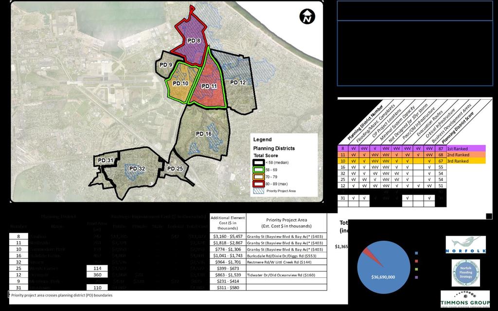
39 Precipitation Study Evaluation 1. Utilize existing resources GIS data Readily available Easily developable Previous study results Actual construction costs 2. Prioritize drainage areas (DAs) based on criteria 3. Develop planning district cost projections based on DA severity 4. Identify priority projects 39
40 Precipitation Study Analysis Scoring system Technical criteria Identified Problem Areas CIP Project Locations Existing Infrastructure Capacity Designed to Convey a 10yr Storm Infrastructure Condition Other criteria (Social & Economic) Road Classification Critical Infrastructure Presence of Business Development Focus Areas 40
41 Precipitation Study Summary 41

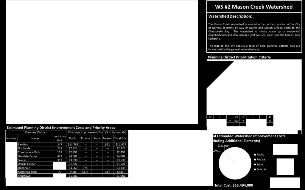
42 Precipitation Infrastructure Analysis Legend Planning Districts Pipes (by Size in Inches) Additional Analysis Data Total Score < 58 (median) (max) Rank in Watershed Ditches Structures 2!( 3 %, Outfalls GF ^_ Major Flooding Areas Constant Flooding Areas Maintenance Areas Areas of Both Flooding & Maintenance Critical Facilities CIP Locations Designed to Pass 10yr Storm Drainage Basins Business Parks, Economic Districts, & Enterprise Zones 42
43 Precipitation Prioritization Scoring System Criteria Impact on residences and businesses Identified problem areas Impact on access to critical facilities and infrastructure Condition and capacity of existing system Relative cost/affordability Opportunities with other projects and development Design to 10-yr storm capacity 43
44 Norfolk s Actions To Date Created Environmental Stormwater Fund for Water Quality & Water Quantity Improvements Implemented Numerous Stormwater Systems Upgrades Improved Planning & Design of New Projects Installed Tide Gauges Across the City to Determine Differential Tide Levels Programmatic Assessment of Watersheds City-wide What options work Prioritizing efforts across watersheds Established Regional Partnerships to Expand Outreach Engaged Citizens in the Flooding Conversation Completed Coastal Flood Study with Fugro Atlantic Completed City-wide Precipitation Flood Study with Timmons 44
45 Norfolk s Actions (cont d) Developing a strategic plan for the entire City that will guide the application of resources city-wide to address storm water and flooding Met with Congressmen Bobby Scott and Scott Rigell and their staff to discuss the City s flooding issues and the federal government s role Conducted tour of coastal flood prone areas of the City for the U.S. Army Corps of Engineers, District, Division and Headquarters officials Work with the City s delegation to have the State Legislature begin studying and addressing this issue Attempting to reallocate existing funds to begin work on some immediate projects at the federal level 45
46 Summary The City is developing comprehensive strategy to address precipitation and tidal flooding. The City continues to establish enhanced communication and collaboration efforts to increase awareness about our flood prone areas. The City has identified specific mitigation projects that will require significant public investment and intergovernmental coordination. 46

47 Questions? John M. Keifer, Richard Broad, John M. White,
Flooding - Tidal and Rainfall. Presentation to City Council Informal Session May 24, John M. Keifer PE
 Flooding - Tidal and Rainfall Presentation to City Council Informal Session May 24, 2011 John M. Keifer PE Purpose of Presentation 1. Review flooding causes and implications to the City 2. Discuss mitigation
Virginia Beach Comprehensive Sea Level Rise and Recurrent Flooding Planning Study
 1 Virginia Beach Comprehensive Sea Level Rise and Recurrent Flooding Planning Study Policy Recommendations and City-wide Flood Protection Strategies January 15, 2019 2 Agenda Project Overview Hazards and
PW/Engineering. June 20, 2013
 PW/Engineering June 20, 2013 1 Three Questions Why is the Eastern Shore Drive Drainage Area Experiencing Recurrent Flooding? What can be done about it? What is being done? Comprehensively On an Interim
CITY OF NORFOLK COASTAL STORM RISK MANAGEMENT STUDY
 1 CITY OF NORFOLK COASTAL STORM RISK MANAGEMENT STUDY 255 255 255 File Name 237 237 237 217 217 217 200 200 200 0 0 0 163 163 163 131 132 122 239 65 53 80 119 27 252 174.59 110 135 120 112 92 56 62 102
From: John D. Hines, P.E. Re: Old Dominion University Campus Master Plan Sea Level Rise Narrative
 Transportation Land Development Environmental S e r v i c e s Two Columbus Center 4500 Main Street, Suite 400 Virginia Beach, Virginia 23462 Telephone 757 490 0132 Fax 757 490 0136 Memorandum To: File
PRINCESS ANNE DISTRICT STORMWATER PROJECTS
 PRINCESS ANNE DISTRICT STORMWATER PROJECTS Topics o o o o o Sea Level Rise and the Southern Watersheds Ashville Park Sherwood Lakes Kingston Estates Drainage Operations & Maintenance in the Southern Watersheds
PLEASE do not reuse without permission from NYCDEP. [Please notify Pinar Balci and Alan Cohn
 PLEASE do not reuse without permission from NYCDEP. [Please notify Pinar Balci (PBalci@dep.nyc.gov) and Alan Cohn (AlanC@dep.nyc.gov) if you intend to use any of these slides, and indicate where and when
Thank you Dr. Hershner for that kind introduction and for. your leadership at the Virginia Institute of Marine Science.
 Adaptive Planning for Flooding and Coastal Change in Virginia: Legal and Policy Issues for Local Government Plenary Session, Friday, September 13, 2013, 9:30 a.m.- 10:30 a.m. College of William & Mary
Sea Level Rise and Recurrent Flooding Update
 Sea Level Rise and Recurrent Flooding Update Informational Briefing City Council Meeting September 18, 2018 Thomas M. Leahy, Deputy City Manager The Sea, Inland Waters, & Groundwater are Rising Projected
ACKNOWLEDGEMENTS. Sincerely, Executive Director and Staff. Rockingham Planning Commission. 156 Water Street Exeter, NH (603)
") ACKNOWLEDGEMENTS The gratefully acknowledges the participation of coastal New Hampshire municipalities in the preparation of this report: City of Portsmouth Town of New Castle Town of Rye Town of North
ACKNOWLEDGEMENTS The gratefully acknowledges the participation of coastal New Hampshire municipalities in the preparation of this report: City of Portsmouth Town of New Castle Town of Rye Town of North
NEW JERSEY BACK BAYS COASTAL STORM RISK MANAGEMENT INTERIM FEASIBILITY STUDY AND ENVIRONMENTAL SCOPING DOCUMENT. Executive Summary 1 March 2019
 NEW JERSEY BACK BAYS COASTAL STORM RISK MANAGEMENT INTERIM FEASIBILITY STUDY AND ENVIRONMENTAL SCOPING DOCUMENT Executive Summary 1 March 2019 Document Overview This U.S. Army Corps of Engineers (USACE)
November 14, National Sea Grant Climate Network Presentation March 14, 2013
 November 14, 2012 National Sea Grant Climate Network Presentation March 14, 2013 Jason M. Evans, PhD Environmental Policy Program Carl Vinson Institute of Government University of Georgia Most densely
CHAPTER 7. San Dieguito River Flooding Adaptation
 CHAPTER 7 San Dieguito River Flooding Adaptation This chapter includes a range of adaptation measures to address vulnerabilities from flooding along the San Dieguito River, including the river valley,
Hydrology and Flooding
 Hydrology and Flooding Background The 1996 flood Between February 4, 1996 and February 9, 1996 the Nehalem reporting station received 28.9 inches of rain. Approximately 14 inches fell in one 48 hour period.
Regional Approaches to Resiliency
 Regional Approaches to Resiliency Addressing the Impacts of Sea Level Rise COJ Environmental Symposium September 9, 2016 Danielle H. Irwin, PWS, LEED AP Globally, the sea is expected to rise 1 4 by 2100;
Everglades Restoration Climate Program
 Sea Level Change and Long Range Water Resources Planning for Florida Everglades Restoration Climate Program Change Application Concerns of USACE and Guidance Draft Sea Level on Sea Rise Level Planning
COASTAL STRATEGIES FOR DRAINAGE RESILIENCE
 COASTAL STRATEGIES FOR DRAINAGE RESILIENCE FDOT S APPROACH AND VISION TODAY S TOPICS Current Concerns and Trends Risk Tolerance and Design Criteria Long-Term Coastal Planning Area of Recurring Flooding
The newly updated and comprehensive SWMP shall:
 RFQ SCOPE OF SERVICES 2.1 Project Purpose The City of Miami, ( City ) is seeking professional engineering services from a qualified firm for the purpose of planning and developing a newly updated and comprehensive
Atlantic Coast of New York East Rockaway Inlet to Rockaway Inlet and Jamaica Bay, NY
 Atlantic Coast of New York East Rockaway Inlet to Rockaway Inlet and Jamaica Bay, NY Draft Reformulation Public Information October 2016 US Army Corps of Engineers Presentation Outline Project Overview
REGULATORY USE OF BROWARD COUNTY S FUTURE GROUNDWATER ELEVATION MAP
 REGULATORY USE OF BROWARD COUNTY S FUTURE GROUNDWATER ELEVATION MAP CARLOS ADORISIO, P.E. ENVIRONMENTAL ENGINEERING AND PERMITTING DIVISION ENVIRONMENTAL PROTECTION AND GROWTH MANAGEMENT DEPARTMENT Goal
Climate Change and Sea Level Rise Planning and Adaptation Strategies
 Climate Change and Sea Level Rise Planning and Adaptation Strategies Kim Shugar Department Director Intergovernmental Programs Palm Beach County EAR Workshop 4/29/10 Jayantha Obeysekera (Obey) Department
SURREY COASTAL FLOOD ADAPTATION STRATEGY (CFAS) South Nicomekl Irrigation Meeting November 2 nd, 2016
 South Nicomekl Irrigation Meeting November 2 nd, 2016") SURREY COASTAL FLOOD ADAPTATION STRATEGY (CFAS) South Nicomekl Irrigation Meeting November 2 nd, 2016 Project What overview is it? STUDY AREA A 3 year project to help prepare Surrey for a changing climate
SURREY COASTAL FLOOD ADAPTATION STRATEGY (CFAS) South Nicomekl Irrigation Meeting November 2 nd, 2016 Project What overview is it? STUDY AREA A 3 year project to help prepare Surrey for a changing climate
New Jersey Back Bays Coastal Storm Risk Management Feasibility Study. Ocean and Burlington Counties Mayor s Meeting Toms River, NJ June 19, 2018
 New Jersey Back Bays Coastal Storm Risk Management Feasibility Study Ocean and Burlington Counties Mayor s Meeting Toms River, NJ June 19, 2018 1 State of New Jersey Shore Protection Program State of New
QUARTERLY STORMWATER UPDATE FLOOD CONTROL PROJECTS TONI ALGER, P.E. STORMWATER ENGINEERING CENTER ADMINISTRATOR JUNE 26, 2018
 QUARTERLY STORMWATER UPDATE FLOOD CONTROL PROJECTS TONI ALGER, P.E. STORMWATER ENGINEERING CENTER ADMINISTRATOR JUNE 26, 2018 Aragona Drainage Improvements D A S H B O A R D Central Resort District Drainage
TREASURE COAST REGIONAL PLANNING COUNCIL M E M O R A N D U M. To: Council Members AGENDA ITEM 3E
 TREASURE COAST REGIONAL PLANNING COUNCIL M E M O R A N D U M To: Council Members AGENDA ITEM 3E From: Date: Subject: Staff May 19, 2017 Council Meeting Local Government Comprehensive Plan Review Draft
New Castle County, DE. Floodplain Regulations
 New Castle County, DE Floodplain Regulations John J. Gysling, PE CFM Department of Land Use New Castle County, DE February 26, 2009 Today s Presentation Floodplain Protection and Uses Terms and Definitions
Climate Change, Conservation and Coastlines Critical Concerns in South Florida?
 Climate Change, Conservation and Coastlines Critical Concerns in South Florida? Contents Greenhouse gas emissions Climate Challenges Interrelated Impacts Concepts for the Comprehensive Plan Dr. Ana Puszkin-Chevlin
EXHIBIT # ATTACHMENT #
 EXHIBIT # ATTACHMENT # Proposed Text Amendment to the Broward County Land Use Plan II. GOALS, OBJECTIVES AND POLICIES SMART GROWTH AND GREEN/ENERGY EFFICIENT AND SUSTAINABLE LAND USE PATTERNS GOAL A.00.00
EXHIBIT # ATTACHMENT #
 EXHIBIT # ATTACHMENT # Proposed Text Amendment to the Broward County Land Use Plan II. GOALS, OBJECTIVES AND POLICIES SMART GROWTH, AND GREEN/ENERGY EFFICIENT AND SUSTAINABLE LAND USE PATTERNS GOAL A.00.00
QUARTERLY STORMWATER UPDATE FLOOD CONTROL PROJECTS TONI ALGER, P.E. STORMWATER ENGINEERING CENTER ADMINISTRATOR MARCH 27, 2018
 QUARTERLY STORMWATER UPDATE FLOOD CONTROL PROJECTS TONI ALGER, P.E. STORMWATER ENGINEERING CENTER ADMINISTRATOR MARCH 27, 2018 Aragona Drainage Improvements D A S H B O A R D Ashville Park Drainage Improvements
7. NATURAL HAZARDS 7.1 SECTION INTRODUCTION
 7. NATURAL HAZARDS 7.1 SECTION INTRODUCTION 7.1.1 The Resource Management Act empowers Council to control any actual or potential effects of the use, development, or protection of land for the purpose
Sea Level Rise & Flooding
 Sea Level Rise & Flooding Village of Mamaroneck Planning Department WMPF Land Use Training Institute April 5, 2017 Greg Cutler, Assistant Village Planner Full report available at Planning.VillageofMamaroneck.org
Testimony of Shari T. Wilson, Secretary Maryland Department of the Environment. Before. The Senate Committee on Environment and Public Works
 Testimony of Shari T. Wilson, Secretary Maryland Department of the Environment Before The Senate Committee on Environment and Public Works The Clean Energy Jobs and American Power Act (S. 1733) Wednesday,
CITY OF MOUNTAIN VIEW
 CITY OF MOUNTAIN VIEW Incorporate Climate Change Adaptation in Municipal Scale, Urban Watershed Planning at the City of Mountain View Raymond Wong, PhD, PE, LEED AP Lisa Au, PE Floodplain Management Association
TOWN OF HAMPTON FALLS, NEW HAMPSHIRE
 TIDES TO STORMS PREPARING FOR NEW HAMPSHIRE S FUTURE COAST Assessing Risk and Vulnerability of Coastal Communities to Sea Level Rise and Storm Surge Seabrook - Hampton Falls Hampton - North Hampton Rye
beachsamp Rhode Island Shoreline Change Special Area Management Plan
 beachsamp Rhode Island Shoreline Change Special Area Management Plan Nowhere else in the U.S. is there a management plan for tackling the complicated impacts associated with sea level rise, and Rhode Island
TOWN OF NEW CASTLE, NEW HAMPSHIRE
 TIDES TO STORMS PREPARING FOR NEW HAMPSHIRE S FUTURE COAST Assessing Risk and Vulnerability of Coastal Communities to Sea Level Rise and Storm Surge New Castle - Portsmouth Seabrook - Hampton Falls Hampton
Chapter 9. Coastal Hazards and Adaptation 1
 Chapter 9. Coastal Hazards and Adaptation 1 9.1 Introduction Like other coastal municipalities in New Hampshire, Seabrook is confronted by a challenging set of land use and hazard management concerns that
SURREY COASTAL FLOOD ADAPTATION STRATEGY (CFAS) General Phase 1 Workshop Presentation (February 3 through March 8, 2017)
 General Phase 1 Workshop Presentation (February 3 through March 8, 2017)") SURREY COASTAL FLOOD ADAPTATION STRATEGY (CFAS) General Phase 1 Workshop Presentation (February 3 through March 8, 2017) Agenda Introductions and Overview Project Overview Activity 1 Hazards BREAK Activity
SURREY COASTAL FLOOD ADAPTATION STRATEGY (CFAS) General Phase 1 Workshop Presentation (February 3 through March 8, 2017) Agenda Introductions and Overview Project Overview Activity 1 Hazards BREAK Activity
QUARTERLY STORMWATER UPDATE FLOOD CONTROL PROJECTS PHIL PULLEN, P.E. CITY ENGINEER DECEMBER 11, 2018
 QUARTERLY STORMWATER UPDATE FLOOD CONTROL PROJECTS PHIL PULLEN, P.E. CITY ENGINEER DECEMBER 11, 2018 D a s h b o a r d Aragona Drainage Improvements, 7-400 Ashville Park Drainage Improvements Phase I,
Restoring Wreck Pond Inlet Jenna Krug, Habitat Restoration Coordinator
 Restoring Wreck Pond Inlet Jenna Krug, Habitat Restoration Coordinator Borough of Spring Lake Borough of Sea Girt Project Location: Wreck Pond Watershed ~12.8 square miles (8,172 acres) Drains the following
Stormwater Improvement for St. Armands Key
 Stormwater Improvement for St. Armands Key Michael A. Hanson, P.E. Senior Engineer Boyle Engineering Corporation 5971 Cattleridge Boulevard, Suite 200 Sarasota, Florida 34232 Rajaraman Jayakrishnan, Ph.D.
Using the Brute Force Method to Push Back Flood Waters as a Result of Sea Level Rise in Miami Beach
 Using the Brute Force Method to Push Back Flood Waters as a Result of Sea Level Rise in Miami Beach Presentation to the South Florida Hydrologic Society December 3, 2014 Flooding in Miami Beach West Avenue
Hackensack River Flood Reduction Study Update
 Township of River Vale Hackensack River Flood Reduction Study Update November 11, 2013 Purpose of Study To Analyze Where Frequent Flooding Is Impacting Property and How It Might Be Reduced Hackensack River
CHAPTER 7. San Dieguito River Flooding Adaptation
 CHAPTER 7 San Dieguito River Flooding Adaptation This chapter includes a range of adaptation measures to address vulnerabilities from flooding along the San Dieguito River, including the river valley,
PEARCE CREEK CONFINED DISPOSAL AREA MODIFICATION
 US Army Corps of Engineers Philadelphia District PEARCE CREEK CONFINED DISPOSAL AREA MODIFICATION CECIL COUNTY MARYLAND STORMWATER MANAGEMENT PLAN NARRATIVE INITIAL SUBMISSION JUNE 2014 1 PEARCE CREEK
Coastal Hazards Vulnerability and Fiscal Impact Study Report:
 Agenda Item B.1 Coastal Hazards Vulnerability and Fiscal Impact Study Report: Vulnerability Assessment and Adaptation Strategies Review October 12, 2015 Planning Commission Meeting Presentation by: Anne
Memorandum. Executive Summary
 277 Bendix Road Suite 300 Virginia Beach, VA 23452 Main: 757-466-1732 Fax: 757-466-1493 Memorandum To: The City of Virginia Beach From: Lewis White and Rachael Johnson on behalf of WSP Parsons Brinckerhoff
Lessons [being] learnt 2016 Flood in Cedar Rapids. Sandy Pumphrey Project Engineer II Flood Mitigation
![Lessons [being] learnt 2016 Flood in Cedar Rapids. Sandy Pumphrey Project Engineer II Flood Mitigation](/thumbs/77/74998790.jpg "Lessons [being] learnt 2016 Flood in Cedar Rapids. Sandy Pumphrey Project Engineer II Flood Mitigation") Lessons [being] learnt 2016 Flood in Cedar Rapids Sandy Pumphrey Project Engineer II Flood Mitigation 319 286 5363 s.pumphrey@cedar-rapids.org Agenda 2008 Flood Event 2016 Flood Event [Long Term] Flood
Lessons [being] learnt 2016 Flood in Cedar Rapids Sandy Pumphrey Project Engineer II Flood Mitigation 319 286 5363 s.pumphrey@cedar-rapids.org Agenda 2008 Flood Event 2016 Flood Event [Long Term] Flood
CITY OF PORTSMOUTH, NEW HAMPSHIRE
 TIDES TO STORMS PREPARING FOR NEW HAMPSHIRE S FUTURE COAST Assessing Risk and Vulnerability of Coastal Communities to Sea Level Rise and Storm Surge Seabrook - Hampton Falls Hampton - North Hampton Rye
5/25/2017. Overview. Project Background Information. Project Background Information Modeling Approach Model Development Results Next Steps
 City of Corpus Christi Downtown 2D Mapping Effort Brandon Hilbrich, PE, CFM Jake Fisher, PE, CFM Curtis Beitel, PE, CFM 2016 HDR, Inc., all rights reserved. Overview Project Background Information Modeling
DRAINAGE MASTER PLAN FOR THE TOWN OF BLOOMING GROVE AND VILLAGES OF WASHINGTONVILLE AND SOUTH BLOOMING GROVE
 DRAINAGE MASTER PLAN FOR THE TOWN OF BLOOMING GROVE AND VILLAGES OF WASHINGTONVILLE AND SOUTH BLOOMING GROVE PUBLIC MEETING March 8, 2017 LOGISTICS Meeting Agenda: Presentation (7:15 7:45 pm) [Auditorium]
U.S. Army Corps of Engineers Broward County Planning Assistance to States. Flood Risk Management Study for Tidally Influenced Coastal Areas
 U.S. Army Corps of Engineers Broward County Planning Assistance to States Flood Risk Management Study for Tidally Influenced Coastal Areas Initial Stakeholder Resiliency Meeting Wednesday, November 9,
SOUTHEAST FLORIDA S RESILIENT WATER RESOURCES INCLUDING A CASE STUDY FOR THE CITY OF POMPANO BEACH
 SOUTHEAST FLORIDA S RESILIENT WATER RESOURCES INCLUDING A CASE STUDY FOR THE CITY OF POMPANO BEACH SOUTHEAST FLORIDA S WATER INFRASTRUCTURE IS VULNERABLE TO CLIMATE CHANGE THE WATER INFRASTRUCTURE IN FLORIDA
Metro Providence Climate-Smart Region
 Source Connect 16.67% Connect people to Job Centers This model identifies the most direct routes with potential for active transportation demand for the following scenarios: 1) from center of block groups
CHAPTER 3. PLANNING BASIC: LAND USE PLANNING AND ZONING
 CHAPTER 3. PLANNING Communities use planning to direct development and public projects and ensure their land use regulations (zoning) meet the community s needs. When done correctly, planning can prevent
Proactive Planning for Resilient Coasts Lessons for North Texas
 Proactive Planning for Resilient Coasts Lessons for North Texas Kimberly M. Miller, Senior Planner & Operations Manager, Allen Engineering and Science Overview of Today s Program 1. Planning for Coastal
Tools for Visualizing Sea Level Rise Impacts and Resiliency Planning
 Tools for Visualizing Sea Level Rise Impacts and Resiliency Planning Richard Lathrop Raritan River Workshop December 6, 2013 Coastal Community Resiliency Progression Understand the Issues Assess Risk and
Sawmill Brook Culvert and Green Infrastructure Analysis
 Sawmill Brook Culvert and Green Infrastructure Analysis Looking at Impacts of Climate Change in Both a Coastal and Riverine Environment Mary Reilly, Grants Administrator Town of Manchester-by-the-Sea Massachusetts
Environmental Check List Georgia Environmental Policy Act
 Environmental Check List Georgia Environmental Policy Act Project No. : Project Name: GEORGIA IS AREA AFFECTED? IF AFFECTED, HOW SEVERELY? AREA/CATEGORY NO YES UNKNOWN MINOR MEDIAN MAJOR UNKNOWN 1. Wetlands
ACKNOWLEDGEMENTS. Sincerely, Executive Director and Staff. Rockingham Planning Commission. 156 Water Street Exeter, NH (603)
") ACKNOWLEDGEMENTS The gratefully acknowledges the participation of coastal New Hampshire municipalities in the preparation of this report: City of Portsmouth Town of New Castle Town of Rye Town of North
ACKNOWLEDGEMENTS The gratefully acknowledges the participation of coastal New Hampshire municipalities in the preparation of this report: City of Portsmouth Town of New Castle Town of Rye Town of North
Case Study of Bridge Hurricane Vulnerability and Resilience Retrofit Planning Considering Varying Sea Level Rise Predictions
 Case Study of Bridge Hurricane Vulnerability and Resilience Retrofit Planning Considering Varying Sea Level Rise Predictions First International Conference on Surface Transportation System Resilience to
PUBLIC INFORMATION MEETING Rahway River Basin Flood Risk Management Feasibility Study
 PUBLIC INFORMATION MEETING Rahway River Basin Flood Risk Management Feasibility Study COL Paul E. Owen District Engineer U.S. Army Corps of Engineers New York District New Jersey Department of Environmental
Chapter 3. Coastal Hazards and Climate Adaptation 1
 Chapter 3. Coastal Hazards and Climate Adaptation 1 3.1 Introduction Like other coastal municipalities in New Hampshire, Rye is confronted by a challenging set of concerns relating to coastal hazards and
consulting engineers and scientists
 consulting engineers and scientists Flood Resiliency Planning with Modeling of Potential Cumulative Damages Naval Station Mayport with 5 of sea level rise SAME Savannah Post Technical Sessions Jonathan
Coastal Green Infrastructure Techniques for the Protection of SR 1 Vulnerability Assessment and Demonstration
 Coastal Green Infrastructure Techniques for the Protection of SR 1 Vulnerability Assessment and Demonstration Field Seminar No. 1 The Delaware Floodplain: Impacts of Severe Storms on Infrastructure in
U.S. Army Corps of Engineers New Jersey Back Bays Flood Risk Management Planning Workshop. Background Reading/Pre Workshop Activity
 U.S. Army Corps of Engineers New Jersey Back Bays Flood Risk Management Planning Workshop Background Reading/Pre Workshop Activity Introduction The U.S. Army Corps of Engineers (USACE), the USACE National
Protecting Open Space & Ourselves
 Protecting Open Space & Ourselves Reducing Flood Risk in the Gulf of Mexico Through Strategic Land Conservation NATURE.ORG/GULF PROTECTING OPEN SPACE & OURSELVES: REDUCING FLOOD RISK IN THE GULF OF MEXICO
QUARTERLY STORMWATER UPDATE FLOOD CONTROL PROJECTS TONI ALGER, P.E. CITY ENGINEER S OFFICE/STORMWATER ENGINEERING CENTER DECEMBER 12, 2017
 QUARTERLY STORMWATER UPDATE FLOOD CONTROL PROJECTS TONI ALGER, P.E. CITY ENGINEER S OFFICE/STORMWATER ENGINEERING CENTER DECEMBER 12, 2017 D A S H B O A R D Aragona Drainage Improvements Ashville Park
Perimeter protection such as seawalls and levees (or raised roadways serving as levees)
") INTRODUCTION This document discusses flood issues and some conceived strategies to alleviate such issues in the Back Bay. The Back Bay experiences frequent wind tides that push water against the surrounding
INTRODUCTION This document discusses flood issues and some conceived strategies to alleviate such issues in the Back Bay. The Back Bay experiences frequent wind tides that push water against the surrounding
To: From: Date: Subject: Sherwood Lakes Drainage Alternatives Analysis 1
 To: From: The City of Virginia Beach Lewis White and Rachael Johnson on behalf of WSP Date: June 6, 2017 Subject: s Drainage Alternatives Analysis This memorandum represents the summary of findings from
Municipal Stormwater Management Plan Prepared For The Borough of Cape May Point By Van Note-Harvey Associates VNH File No.
 Municipal Stormwater Management Plan Prepared For The Borough of Cape May Point By Van Note-Harvey Associates 2005 VNH File No. 35317-210-21 Table of Contents Introduction... 3 Goals... 3 Storm water Discussion...
Building Partnerships for Climate and Health Programs FINAL REPORT
 Building Partnerships for Climate and Health Programs FINAL REPORT 8/30/12 Prepared for: The Association of State and Territorial Health Officials 2231 Crystal Drive Arlington, VA 22202 Prepared By: New
The State of New Jersey s Shore Protection Program
 Oakwood Beach Storm Damage Reduction Project NJDEP-Bureau of Coastal Engineering Glenn Golden, Project Manager U.S. Army Corps Civil Works Programs Branch Dwight Pakan, Project Manager, Philadelphia District
8 MANAGING THE EFFECTS OF NATURAL HAZARDS
 8 MANAGING THE EFFECTS OF NATURAL HAZARDS 8.1 RESOURCE MANAGEMENT ACT OBLIGATIONS 8.1.1 A natural hazard is defined under Section 2 as being Any atmospheric or earth or water related occurrence (including
Part 8 Natural hazards
 Part 8 Natural hazards Contents Page 8.1 Introduction... 3 8.2 Resource management issue... 3 8.3 Objectives and policies... 3 8.4 Resource management strategy... 5 8.5 Rules - restricted discretionary
transportation, infrastructure, & flood control strategy FINAL DRAFT June 20, 2008
 transportation, 7 infrastructure, & flood control strategy Buckroe The Transportation, Infrastructure, and Flood Control analysis was prepared by Kimley-Horn & Associates. The following sections provide
GENERAL OVERVIEW MEETING JANUARY 10, 2019
 Upper Barataria Basin Coastal Storm Risk Management and The Amite River and Tributaries-Comprehensive Study East of the Mississippi River, Louisiana Feasibility Studies GENERAL OVERVIEW MEETING JANUARY
City of Satellite Beach Community Resiliency. Courtney H. Barker, AICP City Manager
 City of Satellite Beach Community Resiliency Courtney H. Barker, AICP City Manager City of Satellite Beach Intro Situated on an barrier island between the Banana River and the Atlantic Ocean 15 miles south
- His current map can show variation in height across the width of a road as well as along the length of the road.
 February 16, 2018 MEETING NOTES: Dr. Norman Levine, Professor of Geology, College of Charleston Director of Santee Cooper GIS Laboratory and Low Country Hazards Center E-mail: LevineN@cofc.edu Lucas Martinez,
Town of Duxbury Climate Vulnerability Assessment and Action Plan
 Town of Duxbury Climate Vulnerability Assessment and Action Plan April 2018 ACKNOWLEDGEMENTS The project was conducted by the Metropolitan Area Planning Council (MAPC) with funding from MAPC s Planning
Phase II: Proposed (regulated) Impervious in disturbed area (ac) Long Lake Existing Impervious in disturbed area (ac)
 Impervious in disturbed area (ac) Long Lake Existing Impervious in disturbed area (ac)") Permit Application No.: 17-181 Rules: Erosion Control, Wetland Protection, and Waterbody Crossings & Structures Applicant: Hennepin County Received: 4/27/17 Project: CSAH 112 Phase II Complete: 9/5/17
Permit Application No.: 17-181 Rules: Erosion Control, Wetland Protection, and Waterbody Crossings & Structures Applicant: Hennepin County Received: 4/27/17 Project: CSAH 112 Phase II Complete: 9/5/17
TOWN OF KILL DEVIL HILLS, NORTH CAROLINA ANNUAL PROGRESS REPORT ON ADOPTED HAZARD MUTIGATION PLAN COMMUNITY #
 TOWN OF KILL DEVIL HILLS, NORTH CAROLINA ANNUAL PROGRESS REPORT ON ADOPTED HAZARD MUTIGATION PLAN COMMUNITY # 375353 Since the last application for continued participation in the Community Rating System
Cost-Benefit Analysis for Sea Level Rise Adaptation Scenarios
 ARCCA Learning Session Cost-Benefit Analysis for Sea Level Rise Adaptation Scenarios Wednesday, March 21 st 1:00 2:00 PM PST Learning Session Agenda Webinar Logistics Brief overview of ARCCA Featured Presentation
Sea Level Rise: Impacts, Adaptation and Information Gaps
 University of New Orleans ScholarWorks@UNO Coastal Resilience Workshop Coastal Resilience Workshop 2015 Oct 28th, 10:00 AM - 12:00 PM Sea Level Rise: Impacts, Adaptation and Information Gaps Jeffrey R.
SANDY POINT SEWAGE TREATMENT PLANT UPGRADE: PIEVC CLIMATE CHANGE VULNERABILITY ASSESSMENT
 Environment SANDY POINT SEWAGE TREATMENT PLANT UPGRADE: PIEVC CLIMATE CHANGE VULNERABILITY ASSESSMENT Municipality of the District of Shelburne, Nova Scotia PIEVC Process at Pre-Design Presentation Outline:
Ed Apalinski, New Jersey Department of Environmental Protection
 Ed Apalinski, New Jersey Department of Environmental Protection edward.apalinski@dep.gov.nj Hurricane Sandy October 22-November 5, 2012 - Hurricane Sandy, as a hurricane and a post-tropical cyclone, kills
City of Madison: 2017 Capital Budget Capital Improvement Plan
 City of Madison: 2017 Capital Budget Capital Improvement Plan Agency: Stormwater Utility Project Summary Backyard Drainage Problems 25,000 25,000 25,000 25,000 25,000 25,000 CIPP Lining Storm Sewer 100,000
CONSTRUCTION PLAN CHECKLIST
 CONSTRUCTION PLAN CHECKLIST The design engineer is responsible for ensuring that plans submitted for city review are in accordance with this checklist. It is requested that the executed checklist be submitted
Project Summary
 Stormwater Utility Capital Improvement Plan Project Summary 2017 2018 2019 2020 2021 2022 Backyard Drainage Problems 25,000 25,000 25,000 25,000 25,000 25,000 CIPP Lining Storm Sewer 100,000 100,000 100,000
Adapting to Rising Tides
 Adapting to Rising Tides A regional program that uses findings, processes, tools and relationships built by ART and its partners to lead and support efforts that increase the resilience of San Francisco
NEPA Scoping Meeting Rahway River Basin, New Jersey Flood Risk Management Feasibility Study
 NEPA Scoping Meeting Rahway River Basin, New Jersey Flood Risk Management Feasibility Study U.S. Army Corps of Engineers New York District New Jersey Department of Environmental Protection Non-Federal
DRAFT. Technical Memorandum. Whitney Road Drainage & Safety Enhancements Phase III Hydraulic Update. Prepared For:
 DRAFT Technical Memorandum Whitney Road Drainage & Safety Enhancements Phase III Hydraulic Update Prepared For: Pinellas County Department of Environment and Infrastructure Division of Engineering and
Good morning, Chairman Yaw, Chairman Yudichak, Chairman Vulakovich, Chairman Costa,
 Testimony of Patrick McDonnell, Secretary Pennsylvania Department of Environmental Protection Joint Hearing on Flooding and Emergency Response Senate Environmental Resources & Energy and Veterans Affairs
NEW CASTLE CONSERVATION DISTRICT. through. (Name of Municipality) PLAN REVIEW APPLICATION DRAINAGE, STORMWATER MANAGEMENT, EROSION & SEDIMENT CONTROL
 PLAN REVIEW APPLICATION DRAINAGE, STORMWATER MANAGEMENT, EROSION & SEDIMENT CONTROL") NEW CASTLE CONSERVATION DISTRICT through (Name of Municipality) PLAN REVIEW APPLICATION DRAINAGE, STORMWATER MANAGEMENT, EROSION & SEDIMENT CONTROL Office use only: Received by Municipality: Received by
NEW CASTLE CONSERVATION DISTRICT through (Name of Municipality) PLAN REVIEW APPLICATION DRAINAGE, STORMWATER MANAGEMENT, EROSION & SEDIMENT CONTROL Office use only: Received by Municipality: Received by
Sabine Pass to Galveston Bay, TX, Coastal Storm Risk Management and Ecosystem Restoration Feasibility Study
 Sabine Pass to Galveston Bay, TX, Coastal Storm Risk Management and Ecosystem Restoration Feasibility Study Public Comment Meetings October 6, 2015 Beaumont, TX October 8, 2015 Freeport, TX Sharon Tirpak,
NEW YORK NEW JERSEY HARBOR AND TRIBUTARIES COASTAL STORM RISK MANAGEMENT
 NEW YORK NEW JERSEY HARBOR AND TRIBUTARIES COASTAL STORM RISK MANAGEMENT 237 217 200 80 237 217 200 119 FEASIBILITY 237 217 200 STUDY 27 255 0 163 131 239 110 112 62 102 130 National Environmental Policy
Sabine Pass to Galveston Bay, TX, Coastal Storm Risk Management and Ecosystem Restoration Feasibility Study
 Sabine Pass to Galveston Bay, TX, Coastal Storm Risk Management and Ecosystem Restoration Feasibility Study Public Comment Meetings October 6, 2015 Beaumont, TX October 8, 2015 Freeport, TX Sharon Tirpak,
What Will Adaptation Cost? An Economic Framework for Coastal Community Infrastructure
 Final Report What Will Adaptation Cost? An Economic Framework for Coastal Community Infrastructure June 2013 Eastern Research Group, Inc. Written under contract for the National Oceanic and Atmospheric
Watershed Activity 1
 Watershed Activity 1 Region: Eastern Coastlines Grade Level(s): 5-8 Time Required: One 45-minute class period Learning Objectives: The students will be able to understand that all water that falls on a