Satellite Ecology initiative for ecosystem function and biodiversity analyses
|
|
|
- Georgiana Hood
- 6 years ago
- Views:
Transcription


1 Satellite Ecology initiative for ecosystem function and biodiversity analyses Key topics: Satellite Ecology concept, networking networks, super-site, canopy phenology, mapping ecosystem functions Hiroyuki Muraoka (Gifu University, Japan) Shin Nagai, Rei-ichiro Ishii, Rikie Suzuki (JAMSTEC, Japan)
 Climate")

2 Background: Ecosystem, Biodiversity and Climate change GEO Biodiversity Observation Network (BON) Climate Ecosystem Organisms Primary production (NPP) and biodiversity Vulnerability assessment of ecosystem functions GEO (2008)


3 Satellite Ecology concept for multiple-observations H 2 O REMOTE SENSING ECOPHYSIOLOGY CO 2 MICROMETEOROLOGY PEN FLUX CH 2 O Process interaction Meteorology Ecosystem Organisms Scale interaction Region Landscape Plots BIOGEO- CHEMISTRY Research plots HYDROLOGY Multiple evaluation of functions Site networks JaLTER + JapanFlux Monitoring sites 1000 Landscape (Muraoka et al. 2012)
4 SATECO initiative to link Earth, Ecosystem & Biodiversity obs. Earth system and ecosystems Biological and ecological processes Earth obs. Ecosystem obs. Biodiversity obs. Satellite remote sensing Ecosystem and landuse types Vegetation structure Temporal change in ecosystems Ecological process research, tower flux obs. and modeling Primary production (carbon cycling) Eco-hydrology Carbon & Nutrient cycling Species and genetic level research Plant species distribution Wildlife habitat assessment Biological interactions Concept by In-Situ/RS integration WG, J-BON (Muraoka et al. 2012)
5 Linking ecosystem functions and biodiversity by RS+model Satellite / Airborne Remote Sensing Forest ecosystem structure and functions Foliage density (LAI) Primary production (NPP) Habitat quality Carbon & Nutrient cycles Biodiversity & Ecosystem services

6 Vegetation structure and NPP as the indicator of biodiversity Ecosystem structure as the habitat for biodiversity Ecosystem function (primary production) as the resource for biodiversity Primary production as the indicator of climate change impacts on ecosystems Ecosystems -food web - biological interaction Climate, topography, landuse Vegetation structure and NPP Biodiversity NPP


7 GPP and bird species richness
 Large scale observation -remote sensing - ecosystem/landuse - land surface (snow, etc) - climate climate ecosystem function biodiversity biogeochemistry Spatial and")
8 Spatial scaling by RS+models based on plot-studies LENS concept by GEO BON (2008) Site (plot) level observation - micrometeorology - biodiversity, population dynamics - ecosystem structure / function Model (statistic, process-based) Large scale observation -remote sensing - ecosystem/landuse - land surface (snow, etc) - climate climate ecosystem function biodiversity biogeochemistry Spatial and temporal dynamics - biodiversity and its change - ecosystem structure / function (Muraoka et al. 2012)


9 Challenge in Japan: cross-scale evaluation by multi-networks Research plots for ecosystem and biodiversity Ecosystem biodiversity relationships at plots Satellite RS & models (canopy phenology, NPP, etc.) Broad-scale ecosystem-biodiversity monitoring and understandings (human impacts, disturbance and climate change, etc.)

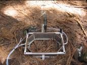


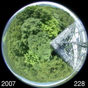
10 Takayama super-site (long-term, multidisciplinary obs.) Takayama Gifu Tokyo JapanFlux/AsiaFlux, JaLTER/ILTER-EAP TKY (Deciduous broadleaf) Since 1993 Eddy covariance TKC (Evergreen coniferous) Since 2005 Leaf physiology Leaf physiology Eddy covariance Tree growth Litter fall Spectral radiometer Soil respiration Soil respiration Canopy phenology


 CO 2")

11 Networking networks at super-sites International Long-Term Ecological Research Network (ILTER) CO 2 /water/heat flux measurements Network (FLUXNET) ILTER-EAP Takayama site (TKY)


12 SATECO-2 (FY ) Climate change impact assessment of forest ecosystem functions by satellite-ecophysiology-modeling integrated study Satellite remote sensing Observation and analysis of; phenology and productivity over years (sign of changes?) In situ measurements photosynthesis, resp., phenology, pigments, N, optical properties, Model analysis Tree and forest photosynthesis, respiration, phenology Accurate assessment of current status of ecosystem functions in deciduous broadleaf forests Near-future prediction of warming impacts on ecosystem processes and functions Warming experiments tree, soil Vulnerability assessment of forest ecosystem functions to climate change


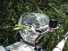
13 Multi-scale remote sensing of canopy processes MS700 Spectro-radiometer MS712 Spectro-radiometer ADFC Digital camera
")

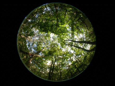
14 In-situ leaf phenology and spectral vegetation index (VI) Spectro-radiometer GRVI 1 km Canopy image
 Leaf senescence date (GRVI <")


15 Mapping leaf phenology by MODIS (Terra, Aqua) Leaf expansion date (GRVI > 0) Leaf senescence date (GRVI < 0) Careful in-situ examination of satellite RS data enables us to map ecosystem functions. Further validation of satellite RS data at ecological research sites is required.


16 GRVI EVI NDVI VIs and canopy productivity Leaf area index Spectral reflectance Leaf, canopy Leaf photosynthetic capacity LAI x Vcmax Daily maximum canopy GPP


 May")


17 From EVI to potential photosynthetic productivity (GPP) EVI(MODIS) May 20 Sep 27 Oct 23 Empirical model at TKY site EVI vs. GPP max May 20 Sep 27 Oct 23 potential GPP GPP max ( mol m -2 s -1 )


18 Networking networks for climate-ecosystem-biodiversity obs. Concepts to be shared Current efforts in Japan Integrations (data, viewpoints) Process interaction climate Ecosystem Biodiversity J-community (2007) In-situ/RS WG of J-BON (2009) Multiple assessment Scale interaction Region Landscape Research Collaborations ILTER-EAP ILTER J-BON AP-BON AsiaFlux FLUXNET Plots GEO BON, GEOSS, others

19 Linking with ILTER for NPP-biodiversity issues International Long Term Ecological Research (ILTER) is a 'network of networks', a global network of research sites located in a wide array of ecosystems worldwide that can help understand environmental change across the globe. ILTER s vision is a world in which science helps prevent and solve environmental and socio-ecological problems. Partner of GEO BON ILTER ILTER-EAP
20 SATECO initiative for In situ / RS integration Recommendations: networkings for cross-scale collaborations (I) Vertically deep laterally sparse network to find consequences among ecosystem composition, structure and functions for various ecosystems along the environmental gradients, by networking super-sites of existing research networks. (II) Vertically shallow laterally dense network to find the general relationships between the ecological aspects of plants, animals, birds and microorganisms (i.e., assessment of habitat quality and preferences, distribution patterns, etc.). (III) Integration of biological, ecological and physical data by GIS to achieve a comprehensive understanding on the ecosystem composition structure functions, and then to predict these changes under climate and human impacts. (Muraoka et al. 2012)
Figure TS.1. (IPCC AR4 WG II)
") IPCC AR4 WG II TS There is more evidence, from a wider range of species and communities in terrestrial ecosystems than reported in the Third Assessment, that recent warming is already strongly affecting
IPCC AR4 WG II TS There is more evidence, from a wider range of species and communities in terrestrial ecosystems than reported in the Third Assessment, that recent warming is already strongly affecting
Remote Sensing and Modeling: A tool to provide the spatial information for biomass production potential
 Remote Sensing and Modeling: A tool to provide the spatial information for biomass production potential K. P. Günther, E. Borg, K. Wißkirchen, M. Schroedter-Homscheidt, B. Fichtelmann, J. Gehrung Folie
Climate Change Research: Monitoring and Detection
 Climate Change Research: Monitoring and Detection John Hom Richard Birdsey Northern Global Change Program Climate, Fire, and Carbon Cycle Science Group USFS Northern Research Station Environmental Monitoring
Dynamic Regional Carbon Budget Based on Multi-Scale Data-Model Fusion
 Dynamic Regional Carbon Budget Based on Multi-Scale Data-Model Fusion Mingkui Cao, Jiyuan Liu, Guirui Yu Institute Of Geographic Science and Natural Resource Research Chinese Academy of Sciences Toward
Canadian Forest Carbon Budgets at Multi-Scales:
 Canadian Forest Carbon Budgets at Multi-Scales: Dr. Changhui Peng, Uinversity of Quebec at Montreal Drs. Mike Apps and Werner Kurz, Canadian Forest Service Dr. Jing M. Chen, University of Toronto U of
Drought Effect on Carbon Sequestration in a Tropical Dry Forest
 1 Drought Effect on Carbon Sequestration in a Tropical Dry Forest By: 1 Saulo Castro Contreras, 1 Arturo Sanchez Azofeifa, 2 Mauricio Vega Araya 3 Hiromitsu Sato, 3 Sharon Cowling and Institutions: 1.
Terrestrial Biogeochemistry in UKESM! Anna Harper, Andy Wiltshire, Rich Ellis, Spencer Liddicoat, Nic Gedney, Gerd Folberth, Eddy Robertson, T
 Terrestrial Biogeochemistry in UKESM! Anna Harper, Andy Wiltshire, Rich Ellis, Spencer Liddicoat, Nic Gedney, Gerd Folberth, Eddy Robertson, T Davies-Barnard, Doug Clark, Margriet Groenendijk, Chris Jones,
Principles of Terrestrial Ecosystem Ecology
 E Stuart Chapin III Pamela A. Matson Harold A. Mooney Principles of Terrestrial Ecosystem Ecology Illustrated by Melissa C. Chapin With 199 Illustrations Teehnische Un.fversitSt Darmstadt FACHBEREIGH 10
Issues of Consideration for the Promotion of the Asia-Pacific Biodiversity Observation Network (AP-BON)-2
-2") The 7 th GEOSS AP Symposium Dai-ichi Hotel Ryogoku 27 May 2014 Tokyo, Japan Issues of Consideration for the Promotion of the Asia-Pacific Biodiversity Observation Network (AP-BON)-2 Eun-Shik KIM Co-chair
The 7 th GEOSS AP Symposium Dai-ichi Hotel Ryogoku 27 May 2014 Tokyo, Japan Issues of Consideration for the Promotion of the Asia-Pacific Biodiversity Observation Network (AP-BON)-2 Eun-Shik KIM Co-chair
National Wildlife Federation Eco-Schools USA
 ATMOSPHERE GLOBE student data within the Atmosphere investigation aids scientific understanding of spatial gaps in air temperature and precipitation coverage by weather monitoring stations, important data
COST Action FP0903, Conference Rome,
 Linking different long-term research and monitoring sites and establishing common protocols that are open for new developments experiences from Switzerland COST Action FP0903, Conference Rome, 5.10.-7.10.2010
WHAT IS THE ACTUAL RELATIONSHIP BETWEEN LAI AND VI IN A DECIDUOUS BROADLEAF FOREST?
 WHAT IS THE ACTUAL RELATIONSHIP BETWEEN LAI AND VI IN A DECIDUOUS BROADLEAF FOREST? S. Potithep a, N. K. Nasahara b, H. Muraoka c, S. Nagai a, R. Suzuki a a Research Institute for Global Change, Japan
Forest change detection and monitoring using passive and active remote sensing data (RS4FOR project)
") Forest change detection and monitoring using passive and active remote sensing data (RS4FOR project) Katarzyna Staszyńska, Ewa Grabska, Anna Zielonka, Katarzyna Ostapowicz Institute of Geography and Spatial
Forest change detection and monitoring using passive and active remote sensing data (RS4FOR project) Katarzyna Staszyńska, Ewa Grabska, Anna Zielonka, Katarzyna Ostapowicz Institute of Geography and Spatial
Vulnerability of Primary Production to Climate Extremes Lessons from the 2003 heatwave in Europe
 Vulnerability of Primary Production to Climate Extremes Lessons from the 2003 heatwave in Europe Ph. Ciais, M. Reichstein, N. Viovy A. Granier, J. Ogée, V. Allard, M. Aubinet, Chr. Bernhofer, A. Carrara,
Factors Affecting Gas Species Released in BB. Factors Affecting Gas Species Released in BB. Factors Affecting Gas Species Released in BB
 Factors Affecting Gas Species Trace from Biomass Burning. The Main Variables* The Amount and Type of gas species released from fire are conditioned by: Chemical and Physical features of the Ecosystem *(Alicia
Peatland Carbon Stocks and Fluxes:
 Peatland Carbon Stocks and Fluxes: monitoring, measurements and modelling Dr Andreas Heinemeyer ah126@york.ac.uk University of York, Stockholm Environment Institute UNFCCC 24 th October 2013 South Africa:
Forest Production Ecology
 Objectives Forest Production Ecology Overview of forest production ecology C cycling Primary productivity of trees and forest ecosystems ecologists and ecosystem managers are unlikely to achieve desired
From climate models to earth system models: the stomatal paradigm and beyond
 From climate models to earth system models: the stomatal paradigm and beyond Gordon Bonan National Center for Atmospheric Research Boulder, Colorado, USA Academy Colloquium Stomatal conductance through
REMOTE SENSING FOR SUSTAINABLE LANDSCAPES ANDREW SKIDMORE
 REMOTE SENSING FOR SUSTAINABLE LANDSCAPES ANDREW SKIDMORE SUSTAINABLE LANDSCAPES Protected areas: 10-15% land surface >100,000 ha 0.12 ha/capita >1,000,000 ha 0.08 ha/capita Wilderness area is larger than
Fundamental of Peatland Mapping Consultation Meeting for Indonesian Climate Change Center (ICCC)
") Fundamental of Peatland Mapping Consultation Meeting for Indonesian Climate Change Center (ICCC) DNPI, 15th August 2011 Mitsuru Osaki Research Faculty of Agriculture, Hokkaido University Kazuyo Hirose
Fundamental of Peatland Mapping Consultation Meeting for Indonesian Climate Change Center (ICCC) DNPI, 15th August 2011 Mitsuru Osaki Research Faculty of Agriculture, Hokkaido University Kazuyo Hirose
Use of EO for integrated Coastal Zone Management [ICZM]
![Use of EO for integrated Coastal Zone Management [ICZM]](/thumbs/78/78380350.jpg "Use of EO for integrated Coastal Zone Management [ICZM]") Use of EO for integrated Coastal Zone Management [ICZM] Prof. George Zalidis Aristotle University of Thessaloniki, School of Agriculture Director of the Laboratory of Applied Soil Science Director of the
Use of EO for integrated Coastal Zone Management [ICZM] Prof. George Zalidis Aristotle University of Thessaloniki, School of Agriculture Director of the Laboratory of Applied Soil Science Director of the
Introduction to a MODIS Global Terrestrial Evapotranspiration Algorithm Qiaozhen Mu Maosheng Zhao Steven W. Running
 Introduction to a MODIS Global Terrestrial Evapotranspiration Algorithm Qiaozhen Mu Maosheng Zhao Steven W. Running Numerical Terradynamic Simulation Group, Dept. of Ecosystem and Conservation Sciences,
Earth Observation for Sustainable Development of Forests (EOSD) - A National Project
 - A National Project") Earth Observation for Sustainable Development of Forests (EOSD) - A National Project D. G. Goodenough 1,5, A. S. Bhogal 1, A. Dyk 1, R. Fournier 2, R. J. Hall 3, J. Iisaka 1, D. Leckie 1, J. E. Luther
Earth Observation for Sustainable Development of Forests (EOSD) - A National Project D. G. Goodenough 1,5, A. S. Bhogal 1, A. Dyk 1, R. Fournier 2, R. J. Hall 3, J. Iisaka 1, D. Leckie 1, J. E. Luther
Satellite-based modeling of gross primary production in an evergreen needleleaf forest
 Remote Sensing of Environment 89 (2004) 519 534 www.elsevier.com/locate/rse Satellite-based modeling of gross primary production in an evergreen needleleaf forest Xiangming Xiao a, *, David Hollinger b,
MODELING GROSS PRIMARY PRODUCTION OF AN EVERGREEN NEEDLELEAF FOREST USING MODIS AND CLIMATE DATA
 Ecological Applications, 15(3), 2005, pp. 954 969 2005 by the Ecological Society of America MODELING GROSS PRIMARY PRODUCTION OF AN EVERGREEN NEEDLELEAF FOREST USING MODIS AND CLIMATE DATA XIANGMING XIAO,
Arctic ecosystems as key biomes in climate-carbon feedback. Hanna Lee Climate and Global Dynamics Division National Center for Atmospheric Research
 Arctic ecosystems as key biomes in climate-carbon feedback Hanna Lee Climate and Global Dynamics Division National Center for Atmospheric Research Outline Permafrost carbon Permafrost carbon-climate feedback
High-resolution Land Cover Mapping Projects in JAXA/EORC
 2017/07/19 LCLUC SARI International Regional Science Meeting in South/Southeast Asia High-resolution Land Cover Mapping Projects in JAXA/EORC Kenlo Nishida Nasahara (奈佐原顕郎) JAXA/EORC Ecology Research Group
EC FLUXES: BASIC CONCEPTS AND BACKGROUND. Timo Vesala (thanks to e.g. Samuli Launiainen and Ivan Mammarella)
") EC FLUXES: BASIC CONCEPTS AND BACKGROUND Timo Vesala (thanks to e.g. Samuli Launiainen and Ivan Mammarella) Scales of meteorological processes: Synoptic scale, ~ 1000 km (weather predictions, ~ day) Mesoscale,
EC FLUXES: BASIC CONCEPTS AND BACKGROUND Timo Vesala (thanks to e.g. Samuli Launiainen and Ivan Mammarella) Scales of meteorological processes: Synoptic scale, ~ 1000 km (weather predictions, ~ day) Mesoscale,
Evaluation and improvement of the Community Land Model (CLM4) in Oregon forests
 in Oregon forests") Biogeosciences, 10, 453 470, 2013 doi:10.5194/bg-10-453-2013 Author(s) 2013. CC Attribution 3.0 License. Biogeosciences Evaluation and improvement of the Community Land Model (CLM4) in Oregon forests T.
Biogeosciences, 10, 453 470, 2013 doi:10.5194/bg-10-453-2013 Author(s) 2013. CC Attribution 3.0 License. Biogeosciences Evaluation and improvement of the Community Land Model (CLM4) in Oregon forests T.
Integration of climate change adaptation : site and landscape responses. Simon Duffield Natural England
 Integration of climate change adaptation : site and landscape responses Simon Duffield Natural England Present more in detail the topics on which the Convention should work, explaining why it would be
Carbon Sequestration and Cycling
 Carbon Sequestration and Cycling Darrel Jenerette University of California Riverside Acknowledgements Isaac Park, Amit Chatterjee, Jen Hooper, Edith Allen, Travis Bean US Forest Service, Kearney Foundation,
Remote sensing: A suitable technology for crop insurance?
 Remote sensing: A suitable technology for crop insurance? Geospatial World Forum 2014 May 9, 2014, Geneva, Switzerland Agenda 1. Challenges using RS technology in crop insurance 2. Initial situation Dominance
Implementation of Forest Canopy Density Model to Monitor Forest Fragmentation in Mt. Simpang and Mt. Tilu Nature Reserves, West Java, Indonesia
 Implementation of Forest Canopy Density Model to Monitor Forest Fragmentation in Mt. Simpang and Mt. Tilu Nature Reserves, West Java, Indonesia Firman HADI, Ketut WIKANTIKA and Irawan SUMARTO, Indonesia
Asia-Pacific Biodiversity Observation Network (AP-BON) in Indonesia
 in Indonesia") Asia-Pacific Biodiversity Observation Network (AP-BON) in Indonesia Country Report on The Seventh GEOSS Asia-Pacific Symposium: Dedy Darnaedi RC Biology, Indonesian Institute of Sciences Presented at The
Asia-Pacific Biodiversity Observation Network (AP-BON) in Indonesia Country Report on The Seventh GEOSS Asia-Pacific Symposium: Dedy Darnaedi RC Biology, Indonesian Institute of Sciences Presented at The
ASSOCIATED STATIONS. characteristics, labelling process and rules INSTRUCTIONS FOR ASSOCIATED STATIONS. ICOS Ecosystem Instructions.
 INSTRUCTIONS FOR characteristics, labelling process and rules Version Release date Summary of changes CONTENTS SUMMARY... 2 ASSOCIATED STATION REQUIREMENTS... 3 LABELLING PROCESS... 4 ETC SERVICES... 5
LiDAR based sampling for subtle change, developments, and status
 LiDAR based sampling for subtle change, developments, and status Erik Næsset Norwegian University of Life Sciences, Norway 2111 2005 Conclusions: 1. LiDAR is an extremely precise tool for measuring forest
3/1/18 USING RADAR FOR WETLAND MAPPING IMPORTANCE OF SOIL MOISTURE TRADITIONAL METHODS TO MEASURE SOIL MOISTURE. Feel method Electrical resistance
 3/1/18 USING RADAR FOR WETLAND MAPPING SOIL MOISTURE AND WETLAND CLASSIFICATION Slides modified from a presentation by Charlotte Gabrielsen for this class. Southeast Arizona: Winter wet period From C.
4) Ecosystem Feedbacks from Carbon and Water Cycle Changes
 Ecosystem Feedbacks from Carbon and Water Cycle Changes") 4) Ecosystem Feedbacks from Carbon and Water Cycle Changes Summary: Climate change can affect terrestrial and marine ecosystems which in turn has impacts on both the water and carbon cycles and then feeds
4) Ecosystem Feedbacks from Carbon and Water Cycle Changes Summary: Climate change can affect terrestrial and marine ecosystems which in turn has impacts on both the water and carbon cycles and then feeds
DYNAMIC VEGETATION MODELLING in JULES using the ED (ECOSYSTEM DEMOGRAPHY) MODEL. Allan Spessa
 MODEL. Allan Spessa") DYNAMIC VEGETATION MODELLING in JULES using the ED (ECOSYSTEM DEMOGRAPHY) MODEL Allan Spessa National Centre for Atmospheric Science Department of Meteorology University of Reading JULES Summer 2009 meeting
DYNAMIC VEGETATION MODELLING in JULES using the ED (ECOSYSTEM DEMOGRAPHY) MODEL Allan Spessa National Centre for Atmospheric Science Department of Meteorology University of Reading JULES Summer 2009 meeting
Carbon Fluxes in Tropical Dry Forests and Savannas: Human, Ecological and Biophysical Dimensions
 Carbon Fluxes in Tropical Dry Forests and Savannas: Human, Ecological and Biophysical Dimensions Dr. Arturo Sanchez-Azofeifa Earth and Atmospheric Sciences Department University of Alberta, Edmonton, Alberta,
Modelling Forest Growth and Carbon Dynamics:
 Modelling Forest Growth and Carbon Dynamics: TRIPLEX Model Development and Applications Changhui Peng (www.crc.uqam.ca) Université du Quebec à Montreal (UQAM) Laboratoire de modélisation écologique et
Fluxes: measurements and modeling. Flux
 Fluxes: measurements and modeling Schlesinger and Bernhardt Pg 135-150 Denmead, 2008 Flux C time Amount of material transferred from one reservoir to the other Source Sink Budget-balance of sources and
Carbon, Part 3, Net Ecosystem Production
 Carbon, Part 3, Net Ecosystem Production Carbon Balance of Ecosystems NEP,NPP, GPP Seasonal Dynamics of Ecosystem Carbon Fluxes Carbon Flux Partitioning Chain-saw and Shovel Ecology Dennis Baldocchi ESPM
Climate and Biodiversity
 LIVING IN THE ENVIRONMENT, 18e G. TYLER MILLER SCOTT E. SPOOLMAN 7 Climate and Biodiversity Core Case Study: A Temperate Deciduous Forest Why do forests grow in some areas and not others? Climate Tropical
Real-time Live Fuel Moisture Retrieval with MODIS Measurements
 Real-time Live Fuel Moisture Retrieval with MODIS Measurements Xianjun Hao, John J. Qu 1 {xhao1, jqu}@gmu.edu School of Computational Science, George Mason University 4400 University Drive, Fairfax, VA
Evaluation of Mixed Forest Evapotranspiration and Soil Moisture using Measured and SWAT Simulated Results in a Hillslope Watershed
 KONKUK UNIVERSITY Evaluation of Mixed Forest Evapotranspiration and Soil Moisture using Measured and SWAT Simulated Results in a Hillslope Watershed 5 August 2010 JOH, Hyung-Kyung Graduate Student LEE,
Singular Research & Technological CSIC. MICINN
 Singular Research & Technological Infrastructure (ICTS) of DOÑANA. CSIC. http://icts-rbd.ebd.csic.es/ MICINN 2006-2009 Ricardo Díaz-Delgado ICTS technical head Doñana Biological Station-CSIC ICTS-Doñana:
Chapter 3 Ecosystem Ecology
 Chapter 3 Ecosystem Ecology Ecosystem Ecology Examines Interactions Between the Living and Non-Living World Ecosystem- A particular location on Earth distinguished by its particular mix of interacting
On SEBI-SEBS validation in France, Italy, Spain, USA and China
 On SEBI-SEBS validation in France, Italy, Spain, USA and China Massimo Menenti Li Jia 2 and ZongBo Su 2 - Laboratoire des Sciences de l Image, de l Informatique et de la Télédétection (LSIIT), Strasbourg,
Crop Growth Remote Sensing Monitoring and its Application
 Sensors & Transducers 2014 by IFSA Publishing, S. L. http://www.sensorsportal.com Crop Growth Remote Sensing Monitoring and its Application Delan Xiong International School of Education, Xuchang University,
Forest Biomes. Chapter 9
 Forest Biomes Chapter 9 9.1 Objectives ~Describe the characteristics of the coniferous forest. ~Explain adaptations that enable organisms to survive in coniferous forests. 9.1 Coniferous Forests Coniferous
ICP Forests. The ICP Forests experience in setting up a joint international forest monitoring scheme
 The ICP Forests experience in setting up a joint international forest monitoring scheme Outline Background Political Scientific/technical Harmonisation Results Further development towards climate change
Spatio-Temporal Assessment of Delhi s Green Cover Change using RS & GIS
 Spatio-Temporal Assessment of Delhi s Green Cover Change using RS & GIS Tanvi Sharma 1, G. Areendran 2, Krishna Raj 3 Mohit Sharma 4 1 Consultant, IGCMC, WWF-India 2 Director, IGCMC, WWF-India 3 Senior
Atul Jain University of Illinois, Urbana, IL 61801, USA
 Brian O Neill, NCAR 2010 LCLUC Spring Science Team Meeting Bethesda, MD April 20-22, 2010 Land-Use Change and Associated Changes in Biogeochemical and Biophysical Processes in Monsoon Asian Region (MAR)
Using Landsat TM Imagery to Estimate LAI in a Eucalyptus Plantation Rebecca A. Megown, Mike Webster, and Shayne Jacobs
 Using Landsat TM Imagery to Estimate LAI in a Eucalyptus Plantation Rebecca A. Megown, Mike Webster, and Shayne Jacobs Abstract The use of remote sensing in relation to determining parameters of the forest
A PROPOSED NEW VEGETATION INDEX, THE TOTAL RATIO VEGETATION INDEX (TRVI), FOR ARID AND SEMI-ARID REGIONS
, FOR ARID AND SEMI-ARID REGIONS") A PROPOSED NEW VEGETATION INDEX, THE TOTAL RATIO VEGETATION INDEX (TRVI), FOR ARID AND SEMI-ARID REGIONS Hadi Fadaei a*, Rikie Suzuki b, Tetsuro Sakai c and Kiyoshi Torii d a Postdoctoral Researcher at
A PROPOSED NEW VEGETATION INDEX, THE TOTAL RATIO VEGETATION INDEX (TRVI), FOR ARID AND SEMI-ARID REGIONS Hadi Fadaei a*, Rikie Suzuki b, Tetsuro Sakai c and Kiyoshi Torii d a Postdoctoral Researcher at
Mar 19 Vegetation Structure: Controls, Patterns, Consequences
 Mar 19 Vegetation Structure: Controls, Patterns, Consequences Landscape Patterns Human Land Use Effects Topics Stand Level Description of vegetation structure Drivers Consequences Landscape Level Habitat
Influence of rainforest architectural and biological diversity on C assimilation along an elevation gradient in Hawaii
 Influence of rainforest architectural and biological diversity on C assimilation along an elevation gradient in Hawaii Eben N. Broadbent PhD Candidate GREF Fellow Department of Biological Sciences, Stanford
Suborbital Measurement Program Using the MEOS Spectrometer (MEOSuB)
") Suborbital Measurement Program Using the MEOS Spectrometer (MEOSuB) J.J. Sloan, R. V. Kruzelecky, K. Strong and J. Lin Workshop on Suborbital Platforms and Nanosatellites Canadian Space Agency, Saint-Hubert,
Suborbital Measurement Program Using the MEOS Spectrometer (MEOSuB) J.J. Sloan, R. V. Kruzelecky, K. Strong and J. Lin Workshop on Suborbital Platforms and Nanosatellites Canadian Space Agency, Saint-Hubert,
BAEN 673 / February 18, 2016 Hydrologic Processes
 BAEN 673 / February 18, 2016 Hydrologic Processes Assignment: HW#7 Next class lecture in AEPM 104 Today s topics SWAT exercise #2 The SWAT model review paper Hydrologic processes The Hydrologic Processes
BIODIVERSITY ASSESSMENT OF JAPANESE URBAN FORESTS
 BIODIVERSITY ASSESSMENT OF JAPANESE URBAN FORESTS Toward a comprehensive assessment of ecosystem services of urban forests in Nagoya, Japan YUSUKE YONEKURA 1, KIICHIRO HAYASHI 1, YASUHIRO HASEGAWA 1, &
ForeSTClim Outline of proposed forest modelling work by Forest Research in Group C + D. Duncan Ray Bill Mason Bruce Nicoll Georgios Xenakis
 ForeSTClim Outline of proposed forest modelling work by Forest Research in Group C + D Duncan Ray Bill Mason Bruce Nicoll Georgios Xenakis Topic areas Assessment of UKCIP08 probabilistic simulations for
OF THE CARBON CYCLE IN THE GEOLAND PROJECT
 Integrated GMES Project on Landcover and Vegetation MODELLING OF THE CARBON CYCLE IN THE GEOLAND PROJECT Co-funded by the European Commission within the GMES initiative in FP-6 ECMWF Seminar project Contents
Y. Inoue a,, J. Peñuelas b, A. Miyata a, M. Mano a
 Available online at www.sciencedirect.com Remote Sensing of Environment 112 (2008) 156 172 www.elsevier.com/locate/rse Normalized difference spectral indices for estimating photosynthetic efficiency and
Forest Changes and Biomass Estimation
 Forest Changes and Biomass Estimation Project Title: Comparative Studies on Carbon Dynamics in Disturbed Forest Ecosystems: Eastern Russia and Northeastern China Supported by NASA Carbon Cycle Science
Ecosystems and the Biosphere Outline
 Ecosystems and the Biosphere Outline Ecosystems Processes in an ecosystem Production, respiration, decomposition How energy and nutrients move through an ecosystem Biosphere Biogeochemical Cycles Gaia
REMOTE SENSING OF ESSENTIAL BIODIVERSITY VARIABLES
 CBD Distr. GENERAL UNEP/CBD/SBI/1/INF/49 18 April 2016 ENGLISH ONLY SUBSIDIARY BODY ON IMPLEMENTATION First meeting Montreal, Canada, 2-6 May 2016 Item 8 of the provisional agenda* REMOTE SENSING OF ESSENTIAL
The Catholic University Ávila
 TheCatholic University Ávila of Academiccourse 2014/2015 INTERNATIONAL PROGRAMS: DIPLOMAS,HONORS ANDCOURSES 1. Diplomas () DIPLOMA IN INTERNATIONAL BUSINESS MANAGEMENT Strategic Management 6 Financial
Biogeochemical Consequences of Land Use Transitions Along Brazil s Agricultural Frontier
 Biogeochemical Consequences of Land Use Transitions Along Brazil s Agricultural Frontier Gillian Galford* 1,2, John Mustard 1, Jerry Melillo 2, Carlos C. Cerri 3, C.E.P. Cerri 3, David Kicklighter 2, Benjamin
Land Surface Phenology: Convergence of Satellite and CO 2
 Land Surface Phenology: Convergence of Satellite and CO 2 Eddy Flux Observations Xiangming Xiao, Junhui Zhang, Huimin Yan, Weixing Wu, and Chandrashekhar Biradar Abstract Land surface phenology (LSP) is
Fluxes: measurements and modeling. Flux
 Fluxes: measurements and modeling Schlesinger and Bernhardt Pg 135-150 Gustin flux paper Griffis, Timothy J. 2013 paper Denmead 2008 Discussion 2 - Work in groups of 2 Papers due to Mae Sept 24 Pick one
Supplementary Material. A - Population density
 Gond, V. et al. Vegetation structure and greenness in Central Africa from MODIS multitemporal data. 2013. Phil Trans Roy Soc B 368 doi: 10.1098/rstb.2012.0309 Supplementary Material A - Population density
Scaling Gross Primary Production (GPP) over boreal and deciduous forest landscapes in support of MODIS GPP product validation
 over boreal and deciduous forest landscapes in support of MODIS GPP product validation") Remote Sensing of Environment 88 (2003) 256 270 www.elsevier.com/locate/rse Scaling Gross Primary Production (GPP) over boreal and deciduous forest landscapes in support of MODIS GPP product validation
Remote Sensing of Environment 88 (2003) 256 270 www.elsevier.com/locate/rse Scaling Gross Primary Production (GPP) over boreal and deciduous forest landscapes in support of MODIS GPP product validation
Above- and Belowground Biomass and Net Primary Productivity Landscape Patterns of Mangrove Forests in the Florida Coastal Everglades
 Above- and Belowground Biomass and Net Primary Productivity Landscape Patterns of Mangrove Forests in the Florida Coastal Everglades Edward Castaneda Robert R. Twilley Victor H. Rivera-Monroy Department
Biophysical modulators of interannual variability in eddy-covariance data
 Biophysical modulators of interannual variability in eddy-covariance data Trevor F. Keenan Lawrence Berkeley National Lab. www.sites.google.com/trevorfkeenan @trevorkeenan Variability in the growth rate
Bioe 515 Lec 4: Environmental gradients, landscape pattern, ecological function
 Bioe 515 Lec 4: Environmental gradients, landscape pattern, ecological function Physical Factors that Pattern Landscapes: climate, landform, soils, water, nutrients. Conceptual Framework The framework
Developing and testing Airborne LiDAR-Based Sampling Procedures for Regional Forest Biomass and Carbon Estimation On-going and New Initiatives
 Developing and testing Airborne LiDAR-Based Sampling Procedures for Regional Forest Biomass and Carbon Estimation On-going and New Initiatives Erik Næsset Norwegian University of Life Sciences Dept. of
THE ASSESSMENT OF RAPID LANDUSE CHANGE AND ITS IMPACT ON SUSTAINABLE FISHERIES
 THE ASSESSMENT OF RAPID LANDUSE CHANGE AND ITS IMPACT ON SUSTAINABLE FISHERIES By: Dewayany Sutrisno National Coordination Agency For Survey And Mapping - Indonesia e-mail: dewayani@bakosurtanal.go.id
Takashi Moriyama & Han Dolman On behalf of GEO Carbon CoP and GEO task CL and contributors
 User Engagement Session 1-2 November, China National Convention Center, Beijing Room 401 The GEO Carbon strategy Takashi Moriyama & Han Dolman On behalf of GEO Carbon CoP and GEO task CL-09-03 and contributors
C Nutrient Cycling Begin Climate Discussion. Day 29 December 2, Take-Home Test Due Dec 11 5 pm No Final Exam
 NREM 301 Forest Ecology & Soils C Nutrient Cycling Begin Climate Discussion Day 29 December 2, 2008 Take-Home Test Due Dec 11 5 pm No Final Exam Our discussions for the semester have centered on Clipsrot
The Biomass mission How it works, what it measures? Thuy Le Toan, CESBIO, Toulouse, France & The Biomass Mission Advisory Group
 The Biomass mission How it works, what it measures? Thuy Le Toan, CESBIO, Toulouse, France & The Biomass Mission Advisory Group Why Synthetic Aperture Radars to observe the world forests? Transmit and
Mission. Selected Accomplishments from Walnut Gulch. Facilities. To develop knowledge and technology to conserve water and soil in semi-arid lands
 USDA-ARS Southwest Watershed Research Center Mission Sound Science for Watershed Decisions To develop knowledge and technology to conserve water and soil in semi-arid lands ARS Watershed Locations Selected
LARGE LANDSCAPE MANAGEMENT AND BIODIVERSITY. Jon Haufler
 LARGE LANDSCAPE MANAGEMENT AND BIODIVERSITY Jon Haufler Landscape An area comprised of a mix of ecosystems 10,000 s to 1,000,000 s of acres Ecosystem Spatially explicit, relatively homogeneous unit that
Patterns of Species Richness Among Biomes
 Patterns of Species Richness Among Biomes Topics and approach What is biodiversity and why is it important? What are the major drivers of species richness? Habitat heterogeneity Disturbance Species energy
Global Climate Observing System
 Global Climate Observing System Dr. William Westermeyer GCOS Secretariat The GCOS Mission To ensure that the data required to meet the needs of users for climate information is obtained and made available
Wetland Management Session
 2 nd International Seminar UNFCCC On Cutting Workshop Edge on Science & Technologies technical towards and Food, scientific Environment aspects of ecosystems and Health with - Focus: high-carbon Civil
GeoCarb. PI: Berrien OU (Leadership, science analysis)
") PI: Berrien Moore @ OU (Leadership, science analysis) Partner Institutions: Lockheed-Martin (instrument) CSU (Algorithms) NASA Ames (Validation) GeoCarb A NASA Earth-Ventures mission, awarded in Dec 2016,
PI: Berrien Moore @ OU (Leadership, science analysis) Partner Institutions: Lockheed-Martin (instrument) CSU (Algorithms) NASA Ames (Validation) GeoCarb A NASA Earth-Ventures mission, awarded in Dec 2016,
Working with the Water Balance
 Working with the Water Balance Forest Hydrology and Land Use Change Paul K. Barten, Ph.D. Professor of Forestry and Hydrology Department of Environmental Conservation www.forest-to-faucet.org The Living
User Awareness & Training: LAND. Tallinn, Estonia 9 th / 10 th April 2014 GAF AG
 User Awareness & Training: LAND Tallinn, Estonia 9 th / 10 th April 2014 GAF AG Day 2 - Contents LAND (1) General Introduction to EO and the COPERNICUS Sentinel Programme Overview of COPERNICUS/GMES LAND
FOREST COVER MAPPING AND GROWING STOCK ESTIMATION OF INDIA S FORESTS
 FOREST COVER MAPPING AND GROWING STOCK ESTIMATION OF INDIA S FORESTS GOFC-GOLD Workshop On Reducing Emissions from Deforestations 17-19 April 2007 in Santa Cruz, Bolivia Devendra PANDEY Forest Survey of
Measuring and Valuing Natural Assets: Ecosystem Services. Steve Polasky University of Minnesota & Natural Capital Project
 Measuring and Valuing Natural Assets: Ecosystem Services Steve Polasky University of Minnesota & Natural Capital Project Introduction Ecosystems, including agricultural systems, provide a wide array of
The National Ecological Observatory Network
 The National Ecological Observatory Network Overview Development / Overview of a Distributed Observatory Distilling Questions Key Design Elements of Observatory Ecological Forecasting philosophy Engagement
Forest degradation has become a
 39 NDVI as indicator of degradation C.L. Meneses-Tovar A method to interpret remote sensing images is applied to over time. Carmen Lourdes Meneses-Tovar is Submanager for Remote Sensing, National Forestry
K&C Phase 3 Brief project essentials. Climate-Relevant Modernization of the National Forest Policy and Piloting of REDD+ Measures in the Philippines
 K&C Phase 3 Brief project essentials Climate-Relevant Modernization of the National Forest Policy and Piloting of REDD+ Measures in the Philippines Francisco B. Tavora, Jr. 1, Jose Don T. De Alban 2, Enrico
Community Properties. Describing Plant Communities. Different views of plant communities. Reading assignment: Chapter 9 in GSF
 Community Properties Reading assignment: Chapter 9 in GSF 9/14/09 1 Describing Plant Communities (functional groups) Box 9A What is a community? How are community boundaries defined? 9/14/09 2 Different
inappropriate to define the growing season length (GLS) based on NEE.
 based on NEE.") Dear Dr. Wohlfahrt, We sincerely thank you for handling the reviewing of our manuscript submitted to Biogeosciences bg-2009-143. We also want to thank you and the other two anonymous revirwer for your
Dear Dr. Wohlfahrt, We sincerely thank you for handling the reviewing of our manuscript submitted to Biogeosciences bg-2009-143. We also want to thank you and the other two anonymous revirwer for your
Predicting Carbon Storage of Great Lakes Forests in the Year 2050: Scientific Challenges and Management Decisions Peter S. Curtis
 Predicting Carbon Storage of Great Lakes Forests in the Year 2050: Scientific Challenges and Management Decisions Peter S. Curtis Department of Evolution, Ecology, and Organismal Biology, The Ohio State
Guide 34. Ecosystem Ecology: Energy Flow and Nutrient Cycles. p://www.mordantorange.com/blog/archives/comics_by_mike_bannon/mordant_singles/0511/
 Guide 34 Ecosystem Ecology: Energy Flow and Nutrient Cycles p://www.mordantorange.com/blog/archives/comics_by_mike_bannon/mordant_singles/0511/ Overview: Ecosystems, Energy, and Matter An ecosystem consists
EC FLUXES: BASIC CONCEPTS AND BACKGROUND. Timo Vesala (thanks to e.g. Samuli Launiainen and Ivan Mammarella)
") EC FLUXES: BASIC CONCEPTS AND BACKGROUND Timo Vesala (thanks to e.g. Samuli Launiainen and Ivan Mammarella) Scales of meteorological processes: Synoptic scale, ~ 1000 km (weather predictions, ~ day) Mesoscale,
EC FLUXES: BASIC CONCEPTS AND BACKGROUND Timo Vesala (thanks to e.g. Samuli Launiainen and Ivan Mammarella) Scales of meteorological processes: Synoptic scale, ~ 1000 km (weather predictions, ~ day) Mesoscale,
Bioenergy & Sustainability a SCOPE series volume Launching the report of a global assesment of bioenergy sustainability
 Environmental Security and Ecosystem Services: biodiversity, restoring soils and protecting ecosystems in bioenergy landscapes, harmonizing forestry and agriculture policies Mateus Batistella Embrapa Satellite