Woodward Avenue Wastewater Treatment Plant Red Hill Creek Outfall Modification Works Joint Stewardship Board City of Hamilton.
|
|
|
- Mark Leonard
- 5 years ago
- Views:
Transcription


1 Woodward Avenue Wastewater Treatment Plant Red Hill Creek Outfall Modification Works Joint Stewardship Board City of Hamilton June 30, 2015
2 Presentation Outline 1. Background 2. Environmental Assessment and Conceptual Design Findings 3. Predesign of Red Hill Creek Outfall Modification Works (2010) 4. Predesign since restart in Next Steps 2
3 1. Background
4 1. Background Project Benefits Woodward Upgrades Project The Woodward Plant has a significant influence on the status and health of Hamilton Harbour. Improved effluent quality under the Woodward Upgrades Project will benefit the local area in a number of ways : 1. A direct contribution towards delisting Hamilton Harbour as an Area of Concern. 2. Improving the green image of Hamilton by providing future environmental protection through advanced wastewater treatment. 3. Improved conditions supporting healthy development of diverse populations of fish and wildlife. 4. Contributions to a more desirable Harbour by significantly reducing nutrient loadings, to lower algae growth, and reducing suspended solids, to improve the clarity of local waters. 5. Contributions to a healthier environment for people that live here and for those that visit the City of Hamilton. A future improved ability to attract tourists. 4
5 1. Background As part of the City of Hamilton s Wastewater Treatment Plant Master Plan and its Wet Weather Flow Master Plan, a number of system improvements were defined including: Increased average day flow capacity of WWTP Upgraded level of tertiary treatment at WWTP Expanded primary treatment capacity for Woodward Avenue Plant Upgraded collection system to minimize Combined Sewer Overflows (CSO) discharge to receiving systems 5
6 1. Background The City of Hamilton s Environmental Assessment (EA) study (2007/2008) identified a number of elements associated with the preferred strategy of reaching these objectives including: Disinfection (new chlorine contact tanks) New Pumping Station Power upgrades Additional system capacity Tertiary Treatment Facility 6
7 1. Background The EA identified that Hydraulic Improvements were required to accommodate the proposed Wastewater Treatment Plant Upgrades (i.e. related to flow capacity). Current plant discharge is to the Red Hill Creek downstream of the Burlington Street Interchange ramps. Upstream maintenance/emergency outfall considered as an alternative long term measure to avoid costly internal hydraulic upgrades to the existing outfall. 7

8 1. Background Existing Outfall Proposed Outfall 8
9 1. Background By introducing 5.8 m 3 /s (average) and 11.6 m 3 /s (peak) of Wastewater Treatment Plant effluent about 0.9 to 1 km (+/-) upstream of the existing outfall, several environmental factors needed to be considered including: Stream stability, Flood risk, Fisheries habitat, Terrestrial habitat. 9
10 1. Background To conduct these assessments, the City, through its prime consultant, engaged the services of the Red Hill Valley Project Team including: Amec Foster Wheeler: Water Resource Engineering Dr. Annable: Stream Morphology C. Portt & Associates: Fisheries Dougan & Associates: Terrestrial Ecology to specifically investigate and prepare a Conceptual Design for the subject reach. The purpose of this assessment was to: Establish feasibility for outfall improvements Better define the scope, process and anticipated costs associated with implementation of a long term solution. 10
11 2. Environmental Assessment and Conceptual Design Findings
12 2. Environmental Assessment and Conceptual Design Findings The change (increase) in flows will change the formative/stable conditions for the creek including: Base flow rate, Sediment transport, Temperature. Due to backwater from the Hamilton Harbour, the only way to bring the creek into equilibrium / balance is by widening the cross-section (i.e. can t go deeper or use combinations). 12
13 2. Environmental Assessment and Conceptual Design Findings The hydraulic and fluvial analysis determined the need to widen crosssection by some 35% (+/-). Due to existing infrastructure (roadway embankments, bridges, treatment plant), widening could not be accommodated in all locations, hence strategic and alternate bank treatment would be required. Any works will need to address Fisheries Act requirements of no net loss of fisheries habitat or protection net gain was the objective. 13

14 2. Environmental Assessment and Conceptual Design Findings 14
15 2. Environmental Assessment and Conceptual Design Findings The Red Hill Creek Valley Project Team recommended three (3) forms of creek bank treatment: Widening and lining with Vegetative Rip-Rap. Crib Walls (or equivalent) in constrained locations at bridge. Lunker TM bank structure (or equivalent) at outside bends. 15


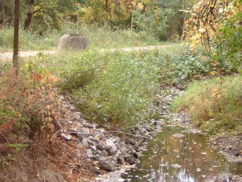

16 2. Environmental Assessment and Conceptual Design Findings Example of Vegetated Rip-Rap Detail Before Add a segment and caption if required. After 16


17 2. Environmental Assessment and Conceptual Design Findings Example of Live Crib Wall Detail Elevation Add a segment and caption if required. Section 17


18 2. Environmental Assessment and Conceptual Design Findings Example of Lunkers TM Construction Side View Add a segment and caption if required. 18

19 2. Environmental Assessment and Conceptual Design Findings Add a segment and caption if required. 19
20 2. Environmental Assessment and Conceptual Design Findings The EA identified a number of factors associated with the next stages of planning and design including, the need to consider: Fluctuating Harbour/Lake levels. Windermere Basin Rehabilitation. Dewatering, material management, fisheries window for construction. Approvals (HCA, DFO, MNRF, MTO, MOECC). EA concluded that project could result in several benefits: Naturalized watercourse Improved water quality Enhanced aquatic habitat Sustainable riparian zone 20
21 3. Predesign of Red Hill Creek Outfall Modification Works (2010).
22 3. Predesign In 2009/2010, the Red Hill Valley Project Team was engaged to prepare the Predesign for the outfall improvement works recommended by the EA; the scope included the following: Bathymetric Survey of Creek Geotechnical & Environmental Investigation of Area soils Terrestrial Habitat Assessment Fisheries Investigation Velocity Profiling Temperature Gauging Supplemental Turtle Survey Hydrologic/Hydraulic Analyses 22
23 3. Predesign Key background data / information included: Woodward Avenue WWTP Existing layout / grading Outfall modifications works, Conceptual Design Assessment Red Hill Valley Parkway Impact Assessment Design Process (IADP) and Permitting Compliance reporting Red Hill Valley Environmental Monitoring Plan Windermere Basin Upgrades / Improvements 23
24 3. Predesign Geotechnical / Materials Sampled soils and subsurface conditions by way of: Boreholes (20) Auger probes (9) Sediment samples (13) Objective to better understand the quality of the materials for: Management / disposal Construction / Engineering 24
25 3. Predesign Terrestrial Existing Conditions Summary Vegetation surveys were conducted in June 2010 including community classification according to ELC and vascular plant species list to confirm composition, abundance and species of conservation concern. The field survey recorded a total of twenty three (23) polygons representing five (5) ELC vegetation community types. A total of 118 species of vascular plants were observed with 71 (60%) considered native in Ontario. 25

26 3. Predesign Terrestrial Existing Conditions Summary 26

27 3. Predesign Terrestrial Existing Conditions Summary 27
28 3. Predesign Fisheries Existing Conditions Red Hill Creek within the study area is low-gradient, and at times in backwater condition. Creek width ranges from about 42 m near the mouth, to 30 m in the vicinity of the existing WWTP outfall, and 20 m in the vicinity of the secondary outfall at Globe Park. Maximum depth is approximately 2.5 m near the mouth, 1.8 m at the existing STP outfall, and 0.7 m in the vicinity of Globe Park. 28
29 3. Predesign Fisheries Overview of Potential Issues The outfall of the upgraded Woodward Ave WWTP will be moved about 1km upstream of the present location, exposing a greater length of Red Hill Creek to treated effluent. Effluent quality from the upgraded WWTP is projected to be dramatically improved over the existing condition, with summer effluent temperatures of approximately 20ºC. Thermal mixing and possible barrier effects of temperature to be considered. The location of the proposed outfall is marsh habitat, that may be utilized by spawning Red Hill Creek fishes. The wetland habitat there will be eliminated. 29
30 3. Predesign River Mechanics and Morphology Existing Conditions and Previous Monitoring Downstream of existing WWTP outfall, the creek is significantly wider relative to upstream. The creek is in the backwater hydraulic of Lake Ontario. From the emergency (maintenance) discharge location downstream the creek is bordered by significant infrastructure. Discharge monitoring has been ongoing by Environment Canada since the 1980 s which will support design. River monitoring below Barton Street has been on-going since 2002 (cross sections, sediment inventory). 30
31 3. Predesign River Mechanics and Morphology Potential Issues Moving the permanent outfall upstream to the current emergency outfall location will alter the channel morphology specifically: Sustained increase in discharge will widen stream, Clear water discharge will further contribute to channel widening, and Channel migration will result. Adjacent infrastructure could be compromised from an increase in channel width. Vertical adjustments in the stream should not occur due to low channel slope. 31
32 3. Predesign Hydrology and Hydraulics Existing Conditions Hydrology Flow rates within the Red Hill Creek in the vicinity of the Woodward Avenue WWTP have been estimated based upon observed flows at the Queenston gauge, as well as the approved HSP-F hydrologic model for the Red Hill Creek Watershed. 32
33 3. Predesign Hydrology and Hydraulics Existing Conditions Hydrology The following background flow rates have been used for this assessment: Baseflow of 0.1 m 3 /s. Observed instantaneous maximum flow rate of 57 m 3 /s (at Queenston gauge) Simulated instantaneous maximum flow rate of 79.9 m 3 /s (using HSP-F) An assessment of the hydraulic impacts of the existing and proposed discharge conditions for the WWTP under low, moderate, and high flow conditions was conducted. 33
34 3. Predesign Hydrology and Hydraulics Existing Conditions Hydrology The hydraulics within Red Hill Creek in the vicinity of the WWTP are influenced By the backwater from Hamilton Harbour, Base flow rate within Red Hill Creek, Geometry of Red Hill Creek (i.e. channel cross-section), Location of discharge from the Woodward Avenue WWTP itself. A total of 24 flow scenarios were evaluated to determine the hydraulic impacts of the proposed WWTP outlet to Red Hill Creek. 34
35 3. Predesign Summary Shallow creek system (0.7 m+/-). Creek bed sediment of poor quality (geotechnical and environmental) 0.3 to 0.6 m thick. High density of breeding birds likely need a pre-clearing contract (September 15 to February 28). No species at risk, 5 species of local concern, none are a constraint. Use of buried seed bank considered excellent restoration opportunity. 35
36 3. Predesign Summary Predominant species of fish include: fathead minnows, green sunfish, pumpkinseed and round goby; limited pike habitat. Baseflow very low 0.1 to 1.0 m 3 /s (Note: proposed WWTP peaks at 11.6 m 3 /s). Average July/August 2010 water temperature was 24.2 C, with a maximum of 30.6 C. Study reach is currently an important nursery area for young-of-theyear white sucker. Geo/environmental assessment shows a range of poor to good quality soil; disposal and re-use opportunities requires careful examination to maintain construction cost effectiveness. 36
37 3. Predesign Summary WWTP expansion site completely covered by Regulatory (Hurricane Hazel) Flood. 100 year flood limits do not extend onto table lands; July 26, 2009 storm caused flows to be 50% higher than 100 year storm peaks Flood protection for development site can be addressed by way of two berm systems; Redesigned railway berm (designed to water retention standards) Backwater prevention berm through the Hamilton Steam Museum lands. Concern with displacement of flood storage due to WWTP expansion advanced to HCA for consideration. 37

38 3. Predesign 70 % Design 38
39 3. Predesign 70 % Design 39
40 3. Predesign 70 % Design 40
41 3. Predesign 70 % Design 41
42 3. Predesign 70 % Design 42
43 4. Predesign since Restart in 2014.
44 4. Predesign Since Re-start in 2014 Early 2011 overall water quality project placed on hold due to variety of factors including: Slower anticipated urban growth (deferral) Reduction in industrial needs Financing / funding 44
45 4. Predesign Since Re-start in 2014 Mid 2014 project re-started Need to re-visit a number of base considerations in the Predesign including: Species at Risk (SAR) to 2015 expectations Fisheries Window for construction Revised flow projections / phasing period for creek system design Flood protection backwater berm Compensatory Triangle 45
46 4. Predesign Since Re-start in 2014 Species-at-Risk (SAR) Additional surveys conducted over 2014 specific to: Amphibians Breeding birds Turtles Two (2) avian SAR observed in 2014 Chimney Swift Barn Swallow neither was nesting in the area; WWTP works deemed not to adversely cause impacts 46
47 4. Predesign Since Re-start in 2014 Species-at-Risk (SAR) Search for snapping turtles resulted in no findings: deemed to be further upstream; WWTP works deemed not to adversely cause impacts No amphibian species detected during nocturnal surveys; Green Frog observed during diurnal surveys; due to habitat conditions no impacts anticipated Species-at-Risk screening Only other species potential Monarch Butterfly Uses common milkweed as host hence no impacts to this is anticipated 47
48 4. Predesign Since Re-start in 2014 Fisheries Window Status of Red Hill Creek as warmwater was potentially being considered to be modified through MNRF. City team engaged MNRF in dialogue concluding that: Red Hill Creek does not support resident salmonid habitat 48
49 4. Predesign Since Re-start in 2014 Fisheries Window As such Given the biological and physical evidence available a fall timing restriction for in-water works for Red Hill Creek seems overly prohibitive. However, the fall migration movement of pacific salmon through the construction site should be monitored at all times 49
50 4. Predesign Since Re-start in 2014 Revised flow Projections / Phasing for Creek System i. Original (2010 +/-) Dry Weather 500 ml/day (5.78 m 3 /s) Maximum Wet Weather 1000 ml/day (11.57 m 3 /s) 5 to 6 year phase-in period (2013/2014 to 2019) ii. Current (2015) Dry Weather 409 ml/day (4.72 m 3 /s) Maximum Wet Weather 614 ml/day (7.09 m 3 /s) 10+ year phase-in period (2015/2016 to 2025) 50
51 4. Predesign Since Re-start in 2014 Revised flow Projections / Phasing for Creek System Three (3) options for consideration: Option 1: Continue to advance 2010 design based on 1000 ml/day maximum (oversize the system short term) Option 2: Consider some proactive measures to allow the current design to adjust over time to allow for the watercourse to be stable over the extended implementation timeframe. (size to ultimate and allow for adjustments) Option 3: Redesign the creek improvements to 2015 flow condition and consider either proactive or reactive measures to transition the system to ultimate flows (allow system to actively erode) 51
52 4. Predesign Since Re-start in 2014 Revised flow Projections / Phasing for Creek System Proactive Approach (Option 2) Preferred Maintains bank stability during the WWTP flow transition period, Lowest of construction costs of the three (3) options considered Ecologically preferable (less sediment deposition and less erosion) More stable than overbuilding the creek 52

53 4. Predesign Since Re-start in 2014 Flood Protection Backwater Berm Current Floodplain 53
54 4. Predesign Since Re-start in 2014 Flood Protection Backwater Berm Design Objective to protect whole of WWTP site to Regulatory standard The proposed berm (which would protect the WWTP during a Regulatory event) may have impacts on adjacent flood levels and spill flows across the QEW. Design developed which requires no manual intervention and avoids impacts to Steam Museum. 54

55 4. Predesign Since Re-start in 2014 Flood Protection Backwater Berm 55
56 4. Predesign Since Re-start in 2014 Compensatory Triangle (Floodplain Optimization) Upon restart, City staff identified a new potential land use constraint associated with the need to possibly protect a portion of the overall land area, previously identified for compensatory cut, for future water plant expansion. As such, new hydraulic analyses were required to assess the impact on flood levels both on-site and off-site. 56

57 4. Predesign Since Re-start in 2014 Compensatory Triangle (Floodplain Optimization) 57
58 4. Predesign Since Re-start in 2014 Compensatory Triangle (Floodplain Optimization) confirms need/requirement for backwater berms limited influence of filling on adjacent flood levels or spill across the QEW continued loss of riparian flood storage, however impact on peak flows <1% need for further consideration of compensation wetland in other locations should this site be utilized for other purposes 58
59 5. Next Steps.
60 5. Next Steps 2010 Predesign is being updated to reflect supplemental work Agency / Regulator Consultation Hamilton Conservation Authority Ministry of Natural Resources and Forestry City Ministry of Transportation Ontario Others Initiate Detailed Design 60

61 61 Thank you
Municipal Class Environmental Assessment for Pottersburg Creek Slope Stability Study South of Hamilton Road, Schedule B
 Municipal Class Environmental Assessment for Pottersburg Creek Slope Stability Study South of Hamilton Road, Schedule B February 13, 2013 Municipal Class EA Process We are here Purpose and Objective of
THE RED HILL VALLEY PROJECT STORMWATER MANAGEMENT DESIGN. Ronald B. Scheckenberger, M. Eng., P. Eng. Philips Engineering Ltd.
 THE RED HILL VALLEY PROJECT STORMWATER MANAGEMENT DESIGN Ronald B. Scheckenberger, M. Eng., P. Eng. Philips Engineering Ltd. Chris Murray Acting Director, Red Hill Valley Project City of Hamilton Paper
Flood Mitigation Opportunities Study Fourteen Mile Creek & McCraney Creek Systems
 Town of Oakville Flood Mitigation Opportunities Study Fourteen Mile Creek & McCraney Creek Systems November 14, 2013 Study Area The limits of the study area extend from Lake Ontario to Dundas Street. McCraney
Public Information Centre No. 2
 Public Information Centre No. 2 Stoney Creek and Battlefield Creek Flood and Erosion Control Project East Escarpment Watershed Restoration Program Conservation Ontario Class Environmental Assessment Date:
Public Information Centre No. 2 June 15, :00 8:00 pm. Valley Park Community Centre (GYM B) 970 Paramount Drive Stoney Creek
 970 Paramount Drive Stoney Creek") Public Information Centre No. 2 June 15, 2017 6:00 8:00 pm Valley Park Community Centre (GYM B) 970 Paramount Drive Stoney Creek Please complete the sign-in sheet and review display materials. The project
Public Information Centre No. 2 June 15, 2017 6:00 8:00 pm Valley Park Community Centre (GYM B) 970 Paramount Drive Stoney Creek Please complete the sign-in sheet and review display materials. The project
South St. Vrain / Hall Meadows Restoration Planning August 20, 2015
 South St. Vrain / Hall Meadows Restoration Planning August 20, 2015 Agenda Introductions Purpose & Goals of Meeting Planning Area Master Plan Restoration Planning: Cost Estimates, Grants, Scope, Timeline
Public Information Centre September 19 th, 2017
 Public Information Centre September 19 th, 2017 WELCOME! Public Information Centre for the Maple Hill Creek Rehabilitation Class Environmental Assessment Please take the time to sign our sign in sheet
Public Information Centre # 2 Flood Mitigation Opportunities Study Fourteen Mile Creek & M c Craney Creek Systems Town of Oakville
 Public Information Centre # 2 Flood Mitigation Opportunities Study Fourteen Mile Creek & M c Craney Creek Systems Town of Oakville Municipal Class Environmental Assessment Study Area The limits of the
Oshawa Creek Watershed Management Plan EXECUTIVE SUMMARY
 Oshawa Creek Watershed Management Plan EXECUTIVE SUMMARY The Central Lake Ontario Conservation Authority (CLOCA) has recognized the need to prepare comprehensive management strategies for all of its watersheds.
Regional Municipality of Halton Skyway Wastewater Treatment Plant Expansion Municipal Class Environmental Assessment Study
 Welcome to the Regional Municipality of Halton Skyway Wastewater Treatment Plant Expansion Municipal Class Environmental Assessment Study September 23, 2009 Please Sign In and take an Information Brief
CREEK RESTORATION/EROSION PROTECTION WORKS. General Submission Requirements
 COMPLETE APPLICATION CHECKLIST Jan 2016 CREEK RESTORATION/EROSION PROTECTION WORKS The following checklist has been compiled to assist the applicant in preparing their application for approval pursuant
Stage 1 Technical Memorandum
 Appendix A Stage 1 Technical Memorandum 2016 Google TECHNICAL MEMORANDUM One River Master Plan Environmental Assessment: Stage 1 Work Plan PREPARED FOR: COPY TO: PREPARED BY: Ashley Rammeloo, City of London
Interesting Solutions for a Culvert Rehabilitation Project in a Sensitive Urban Watershed
 Interesting Solutions for a Culvert Rehabilitation Project in a Sensitive Urban Watershed Jason Stahl, P. Eng., Project Engineer, Amec Foster Wheeler David Sinke, P. Eng., Principal, Transportation Engineering,
Bonsall Creek Watershed Management Plan Gap Analysis
 Bonsall Creek Watershed Management Plan Gap Analysis March 2015 Prepared by Gap Analysis Introduction The Bonsall Creek Watershed Management Plan provides a vision for water use in the watershed, including
TRCA Natural Channel Design Monitoring Program. SOSMART Group Meeting December 7, 2010
 TRCA Natural Channel Design Monitoring Program SOSMART Group Meeting December 7, 2010 Natural Channel Design (NCD) Reconstruction of a stream channel and floodplain using techniques to restore or replicate
Fish Habitat Design, Operation and Reclamation Workbook and Worksheets for Placer Mining in the Yukon Territory
 Fish Habitat Design, Operation and Reclamation Workbook and Worksheets for Placer Mining in the Yukon Territory Version 1.0 April 2008 This document is available from the Yukon Placer Secretariat, Yukon
Detailed Options Evaluation
 Appendix F Detailed Options Evaluation 06 Google Category & Criterion Description Measure/Indicator Natural Environment Rating Scale for Measuring Impacts Comparative Evaluation Score Comparative Evaluation
ILLINOIS URBAN MANUAL PRACTICE STANDARD TEMPORARY STREAM CROSSING (no.) CODE 975. Source: Hey and Associates, Inc.
 CODE 975. Source: Hey and Associates, Inc.") ILLINOIS URBAN MANUAL PRACTICE STANDARD TEMPORARY STREAM CROSSING (no.) CODE 975 Source: Hey and Associates, Inc. DEFINITION A bridge or culvert crossing installed across a stream or watercourse for short-term
ILLINOIS URBAN MANUAL PRACTICE STANDARD TEMPORARY STREAM CROSSING (no.) CODE 975 Source: Hey and Associates, Inc. DEFINITION A bridge or culvert crossing installed across a stream or watercourse for short-term
Chapter 3 Previous Studies
 Chapter 3 Previous Studies The Vista Grande stormwater conveyance system and watershed area has been evaluated in a number of reports and studies for the CCSF, the Daly City and San Mateo County over the
Fish Habitat Design, Operation and Reclamation Workbook and Worksheets for Placer Mining in the Yukon Territory
 Fish Habitat Design, Operation and Reclamation Workbook and Worksheets for Placer Mining in the Yukon Territory Version 1.3 November 2010 This document is available from: Yukon Placer Secretariat, 206B
Appendix M. Criteria, Measures and Indicators for Effects Assessment
 Appendix M Criteria, Measures and Indicators for Effects Assessment Appendix M. Criteria, Measures and Indicators for Effects Assessment Objective 1: Naturalization Changes to Aquatic Habitat Disruption,
Welcome South London Wastewater Servicing Study. Municipal Class Environmental Assessment Master Plan Public Information Centre.
 Welcome South London Wastewater Servicing Study Municipal Class Environmental Assessment Master Plan Public Information Centre February 26, 2018 The purpose of this Public Information Centre (PIC) is to:
Sewer System Flood Reduction Measures in the Rockcliffe Area
 PW28.6 REPORT FOR ACTION Sewer System Flood Reduction Measures in the Rockcliffe Area Date: March 26, 2018 To: Public Works and Infrastructure Committee From: General Manager, Toronto Water Wards: Ward
Controlling CSO Discharges in the City of Toronto: Don River and Central Waterfront Project
 Controlling CSO Discharges in the City of Toronto: Don River and Central Waterfront Project Michael D Andrea, M.E.Sc., P.Eng. Chief Engineer and Executive Director Engineering & Construction Services City
Environmental Assessment Form Part 1 Resource Identification Enclosure C Description of Aquatic Habitat
 Environmental Assessment Form Part 1 Resource Identification Enclosure C Description of Aquatic Habitat 8. Provide a written narrative, identified and labeled as Enclosure C Description of Aquatic Habitat,
Temporary Watercourse Crossing: Culverts
 Temporary Watercourse Crossing: Culverts DRAINAGE CONTROL TECHNIQUE Low Gradient Velocity Control Short Term Steep Gradient Channel Lining Medium-Long Term Outlet Control Soil Treatment Permanent Symbol
Town of Aurora Stream Management Master Plan PUBLIC INFORMATION CENTRE May 1 st, 2018
 Town of Aurora Stream Management Master Plan PUBLIC INFORMATION CENTRE May 1 st, 2018 Your comments are encouraged and appreciated, as this will provide us an opportunity to address project issues and
COON CREEK WATERSHED DISTRICT PERMIT REVIEW Mississippi Dr Coon Rapids, MN SQ FT Residence on 0.64 Acre Lot
 17-082 Van Sloun Residence, Page 1 of 5 COON CREEK WATERSHED DISTRICT PERMIT REVIEW MEETING DATE: May 8, 2017 AGENDA NUMBER: 17 FILE NUMBER: 17-082 ITEM: Van Sloun Residence RECOMMENDATION: Approve with
COON CREEK WATERSHED DISTRICT PERMIT REVIEW
 16-054 Woodland Creek Wetland Banking Restoration Project, Page 1 of 6 COON CREEK WATERSHED DISTRICT PERMIT REVIEW MEETING DATE: August 22, 2016 AGENDA NUMBER: 11 FILE NUMBER: 16-054 ITEM: Woodland Creek
Temporary Stream Crossing
 Categories EC Erosion Control SE Sediment Control TC Tracking Control WE Wind Erosion Control Non-Stormwater NS Management Control Waste Management and WM Materials Pollution Control Legend: Primary Objective
Temporary Stream Crossing
 Temporary Stream Crossing NS-4 Objectives EC Erosion Control SE Sediment Control TR Tracking Control WE Wind Erosion Control Non-Stormwater NS Management Control Waste Management and WM Materials Pollution
May 15, Lower Squaw Creek Restoration Public Workshop. for The Friends of Squaw Creek Truckee River Watershed Council Sierra Nevada Conservancy
 Lower Squaw Creek Restoration Public Workshop for The Friends of Squaw Creek Truckee River Watershed Council Sierra Nevada Conservancy Prepared by: Mike Liquori May 15, 2008 Funding for this project has
CITY OF NEW WESTMINSTER. Bylaw No. 7033, 2005 RIPARIAN AREAS PROTECTION BYLAW
 CITY OF NEW WESTMINSTER Bylaw No. 7033, 2005 RIPARIAN AREAS PROTECTION BYLAW WHEREAS the City may preserve, protect, restore and enhance the natural environment near streams that support fish habitat from
COTTON CREEK CULVERT REPLACMENT
 COTTON CREEK CULVERT REPLACMENT Integrating Mobility with Environmental Innovation Located along a scenic section of Highway 3/95 in British Columbia, Moyie Bluffs, a 6.5 km stretch of inland highway had
Climate Data Training Session April 26, 2017 Ontario Science Centre
 Adaptive Management To Address Climate Change Uncertainty in EA Process A Case Study of the Don Mouth Naturalization and Port Lands Flood Protection Project EA (DMNP EA) Climate Data Training Session April
Stormwater Erosion Control & Post-Construction Plans (Stormwater Quality Plans)
") Stormwater Erosion Control & Post-Construction Plans (Stormwater Quality Plans) Allen County Stormwater Plan Submittal Checklist The following items must be provided when applying for an Allen County Stormwater
Stormwater Erosion Control & Post-Construction Plans (Stormwater Quality Plans) Allen County Stormwater Plan Submittal Checklist The following items must be provided when applying for an Allen County Stormwater
UNDERGROUND UTILITY CROSSING (TRENCHLESS) General Submission Requirements
 General Submission Requirements") COMPLETE APPLICATION CHECKLIST Jan 2016 UNDERGROUND UTILITY CROSSING (TRENCHLESS) The following checklist has been compiled to assist the applicant in preparing their application for approval pursuant
COMPLETE APPLICATION CHECKLIST Jan 2016 UNDERGROUND UTILITY CROSSING (TRENCHLESS) The following checklist has been compiled to assist the applicant in preparing their application for approval pursuant
Planning Considerations for Stormwater Management in Alberta. R. D. (Rick) Carnduff, M. Eng., P. Eng. February 20, 2013.
 Carnduff, M. Eng., P. Eng. February 20, 2013.") Planning Considerations for Stormwater Management in Alberta R. D. (Rick) Carnduff, M. Eng., P. Eng. February 20, 2013 Photo Optional Purpose The purpose of urban stormwater management is to provide solutions
Planning Considerations for Stormwater Management in Alberta R. D. (Rick) Carnduff, M. Eng., P. Eng. February 20, 2013 Photo Optional Purpose The purpose of urban stormwater management is to provide solutions
PUBLIC INFORMATION CENTRE Class Environmental Assessment For. Black Creek Flood Management
 PUBLIC INFORMATION CENTRE Class Environmental Assessment For Conservation Ontario Class Environmental Assessment for Remedial Flood and Erosion Control Projects (2002) The Class EA for Remedial Flood and
Conceptual Design and Feasibility of a Natural Fishway at the Fremont BART Weir, Alameda Creek, California
 Conceptual Design and Feasibility of a Natural Fishway at the Fremont BART Weir, Alameda Creek, California Final Report September 2005 Prepared by Center for Ecosystem Management and Restoration, Oakland,
Temporary Watercourse Crossing: Fords
 Temporary Watercourse Crossing: Fords DRAINAGE CONTROL TECHNIQUE Low Gradient Velocity Control Short Term Steep Gradient Channel Lining Medium-Long Term Outlet Control Soil Treatment Permanent [1] [1]
The following potential environmental receptors and impacts form the basis of TRCA s review under Ontario Regulation 166/06 and the Fisheries Act:
 TRCA Technical Guidelines for the Development of Environmental Management Plans for Dewatering September 2013 Rationale: The Technical Guidelines for the Development of Environmental Management Plans for
Table D1: WC-R1 to WC-R3 (Wilket Creek Park)
") APPENDIX D Table D1: WC-R1 to WC-R3 (Wilket Creek Park) Category of Consideration Criteria Alternative 1 Do Nothing Alternative 2 Local Improvements Alternative 3 Channel Realignment Natural Geomorphic
APPENDIX D Table D1: WC-R1 to WC-R3 (Wilket Creek Park) Category of Consideration Criteria Alternative 1 Do Nothing Alternative 2 Local Improvements Alternative 3 Channel Realignment Natural Geomorphic
The following potential environmental receptors and impacts form the basis of TRCA s review under Ontario Regulation 166/06 and the Fisheries Act:
 Interim TRCA Technical Guidelines for the Development of Environmental Management Plans for Dewatering September 2013 Rationale: The Technical Guidelines for the Development of Environmental Management
Community Services and Utilities & Environmental Protection Report to UE The SPC on Utilities and Environment Page 1 of April 25
 Community Services and Utilities & Environmental Protection Report to UE2007-15 The SPC on Utilities and Environment Page 1 of 2 2007 April 25 ENVIRONMENTAL RESERVE SETBACKS SUMMARY/ISSUE This report recommends
Hamilton Harbour. Area of Concern Status of Beneficial Use Impairments September 2010
 Hamilton Harbour Area of Concern Status of Beneficial Use Impairments September 2010 Hamilton Harbour is a 2150-ha bay located at the western tip of Lake Ontario. The Area of Concern covers about 500 km
SHORELINE INVENTORY AND RESTORATION PLANNING
 CHAPTER 3 SHORELINE INVENTORY AND RESTORATION PLANNING A. PURPOSE OF THE SHORELINE INVENTORY AND CHARACTERIZATION A first step in the comprehensive Master Program update process is development of a shoreline
Massachusetts River and Stream Crossing Standards: Technical Guidelines
 Massachusetts River and Stream Crossing Standards: Technical Guidelines August 6, 2004 INTRODUCTION As long and linear ecosystems, rivers and streams are very important for fish and other wildlife movements,
Chapter 6 Erosion & Stormwater Study Team
 Chapter 6 Erosion & Stormwater Study Team Objective How do we stabilize the Las Vegas Wash environment to most effectively reduce erosion and enhance wetlands? Introduction The Las Vegas Wash (Wash) has
Background. AEM Tier 2 Worksheet Stream & Floodplain Management. Glossary
 AEM Tier 2 Worksheet Stream & Floodplain Management Glossary Bankfull Stage: The stage at which water starts to flow over the flood plain; the elevation of the water surface at bankfull discharge. (This
Chehalis Basin Strategy Programmatic SEPA Draft EIS
 Chehalis Basin Strategy Programmatic SEPA Draft EIS History of Flooding I-5 closed in 1990, 1996, 2007, 2009 Five largest flood events occurred since 1986 2 History of Habitat Degradation Harvest has been
COON CREEK WATERSHED DISTRICT PERMIT REVIEW. Spring Lake Park Schools Westwood Middle School st Avenue NE, Spring Lake Park, MN 55432
 PAN 16-112, Westwood Middle School, Page 1 of 6 COON CREEK WATERSHED DISTRICT PERMIT REVIEW MEETING DATE: August 22, 2016 AGENDA NUMBER: 10 FILE NUMBER: 16-112 ITEM: Westwood Middle School RECOMMENDATION:
Understanding and Restoring Natural Floodplain Function. Gary James CTUIR Fisheries Program Manager
 Understanding and Restoring Natural Floodplain Function Gary James Fisheries Program Manager Future of Our Salmon Technical Workshop on Healthy Floodplains Spokane, WA - August 16-18, 2016 Presentation
7.0 WATER-BASED CONTROL MEASURES
 7.0 WATER-BASED CONTROL MEASURES 7.1 IDENTIFICATION AND DESCRIPTION OF CONTROL MEASURES Table 7-1 lists the water-based options being considered for implementation in the initial screening stage. Descriptions
CHAPTER 3 Environmental Guidelines for WATERCOURSE CROSSINGS GOVERNMENT OF NEWFOUNDLAND AND LABRADOR DEPARTMENT OF ENVIRONMENT AND LABOUR
 GOVERNMENT OF NEWFOUNDLAND AND LABRADOR DEPARTMENT OF ENVIRONMENT AND LABOUR CHAPTER 3 Environmental Guidelines for WATERCOURSE CROSSINGS WATER RESOURCES MANAGEMENT DIVISION Water Investigations Section
Appendix I: Fixed-400,000 af Flood Storage Operation
 Appendix I: Fixed-400,000 af Flood Storage Operation 1.0 FIXED-400,000 AF FLOOD STORAGE OPERATION This operation set provides a comparison of operations before the SAFCA/Reclamation interim agreement in
2012 Toward Safe Harbours Report Card
 2012 Toward Safe Harbours Report Card HamiltonHarbour.ca 2012 Toward Safe Harbours Report Card The Bay Area Restoration Council s 2012 Toward Safe Harbours Report Card is an assessment of the progress
Golf Course and Recreational Facilities Best Management Guidelines. Regional Official Plan Guidelines
 Golf Course and Recreational Facilities Best Management Guidelines Regional Official Plan Guidelines Halton Region Official Plan Guidelines The Regional Official Plan (ROP) is Halton s guiding document
EVALUATION - SECTION 404 OF THE CLEAN WATER ACT DISCHARGE OF SEDIMENTS FROM OR THROUGH A DAM
 EVALUATION - SECTION 404 OF THE CLEAN WATER ACT DISCHARGE OF SEDIMENTS FROM OR THROUGH A DAM U.S. ARMY CORPS OF ENGINEERS, NEW ENGLAND DISTRICT CONCORD, MA PROJECT: Northfield Brook Dam, Naugatuck River
Meacham Creek Restoration Project
 Meacham Creek Restoration Project Meacham Creek Restoration Project Umatilla National Forest Walla Walla Ranger District Michael Rassbach, District Ranger Public Scoping Document Proposal Summary The Walla
CLOCA Rural & Agricultural Guide to Permits
 CLOCA Rural & Agricultural Guide to Permits Regulation of Development, Interference with Wetlands and Alterations to Shoreline and Watercourses, Ontario Regulation 42/06 April 2014 Table of contents Introduction...
DESIGN BULLETIN #16/2003 (Revised July 2007) Drainage Guidelines for Highways Under Provincial Jurisdiction in Urban Areas.
 Drainage Guidelines for Highways Under Provincial Jurisdiction in Urban Areas.") Drainage Guidelines for Highways Under Provincial Jurisdiction in Urban Areas. July 2007 Update to Design Bulletin #16/2003: Added under Design Criteria Culverts of 600mm diameter are commonly used to
Drainage Guidelines for Highways Under Provincial Jurisdiction in Urban Areas. July 2007 Update to Design Bulletin #16/2003: Added under Design Criteria Culverts of 600mm diameter are commonly used to
Lake Samish Comprehensive Stormwater Plan Capital Improvement Recommendations
 Lake Samish Comprehensive Stormwater Plan Capital Improvement Recommendations drainage. The easement could potentially be used to site a surface water quality treatment facility for the flow. The design
The Don River and Central Waterfront are among the most degraded waterways in the City of Toronto.
 This document was put together following the fourth round of public consultation for the Class Environmental Assessment study for this Project. In June 2011, the Project Team consulted with stakeholders
SECTION 10: WETLANDS PROTECTION
 SECTION 10: WETLANDS PROTECTION 10-1 INTENT AND PURPOSE A. Intent 1. The City finds that wetlands serve a variety of beneficial functions. Wetlands maintain water quality, reduce flooding and erosion,
River Restoration, 2018 Has stormwater management been our Achilles Heel in River Management?
 River Restoration, 2018 Has stormwater management been our Achilles Heel in River Management? By Bill Annable, PhD, PhD, PEng, PE, PGeo Department of Civil & Environmental Engineering, University of Waterloo
Lower Mission Creek Watershed Status Survey 2002
 Lower Mission Creek Watershed Status Survey 2002 Prepared For: Mosquito Creek Stewardship Society Prepared By: Fernando F. Junqueira, Ph.D. August 16, 2002 North Vancouver, August 16, 2002 ENVIRONMENTAL
719 Griswold, Suite 820 Detroit, MI DANVERS POND DAM REMOVAL AND STREAM RESTORATION PROJECT
 Great Lakes Restoration Initiative Grant Final Report US EPA Grant GL 00E006 43 October, 2013 Valley Woods Wetland Southfield Lola Valley Grow Zone Wayne County Parks Venoy Park Grow Zone Wayne County
S.R. 4007, Section 14B PADEP Environmental Assessment Form. Enclosure C Description of Aquatic Habitat
 S.R. 4007, Section 14B PADEP Environmental Assessment Form Description of Aquatic Habitat Cresheim Creek is the only water resource that exists within the project area. No jurisdictional wetlands were
Facilities Plan. Technical Memorandum No. TM-WW-7 Hydraulic Analysis and Effluent Pump Station
 City of St. Joseph, Missouri Hydraulic Analysis and Effluent Pump Station By Work Order No. 09-001 B&V Project 163509 May 20, 2010 Table of Contents 1.0 Executive Summary...1 2.0 Purpose of Study...2 3.0
Please complete the sign-in sheet and review display materials.
 Municipal Class Environmental Assessment Please complete the sign-in sheet and review display materials. As you move through the information presented today, we encourage you to ask questions and provide
Hydromodification Management Measures
 Chapter 7 Hydromodification Management Measures This Chapter summarizes the requirements for controlling erosive flows from development projects. 7.1 Why Require Hydromodification Management? Changes in
Hydromodification Management Measures
 Chapter 7 Hydromodification Management Measures This Chapter summarizes the requirements for controlling erosive flows from development projects. 7.1 Why Require Hydromodification Management? Changes in
APPENDIX E SECTION 404 (B) (1) EVALUATION OF DREDGE AND FILL MATERIAL
 (1) EVALUATION OF DREDGE AND FILL MATERIAL") APPENDIX E SECTION 404 (B) (1) EVALUATION OF DREDGE AND FILL MATERIAL SECTION 404 (B) (1) EVALUATION FOR AUGUSTA ROCKY CREEK SECTION 205 FEASIBILITY STUDY, RICHMOND COUNTY, GEORGIA FEBRUARY 2016 TABLE
APPENDIX E SECTION 404 (B) (1) EVALUATION OF DREDGE AND FILL MATERIAL SECTION 404 (B) (1) EVALUATION FOR AUGUSTA ROCKY CREEK SECTION 205 FEASIBILITY STUDY, RICHMOND COUNTY, GEORGIA FEBRUARY 2016 TABLE
RIPARIAN AREAS REGULATION
 Definitions and interpretation RIPARIAN AREAS REGULATION 1 (1) In this regulation: Act means the Fish Protection Act; active floodplain means an area of land that supports floodplain plant species and
Fraser River Water Quality
 Richmond Environmental Project Guidebook Fraser River Water Quality Why You Should Care About This Issue The Fraser River is the largest river in British Columbia. The health of the Fraser River is important
Scenario Modeling and Restoration Implications
 Scenario Modeling and Restoration Implications Paul Kolp 1, Matt Van Ess 2, Keith Marcoe 1, Sam Geisse 2 1 Lower Columbia Estuary Partnership 2 Columbia River Estuary Study Taskforce 1 Background Estuary
ENVIRONMENT ACT TERMS OF REFERENCE NOVA SCOTIA DEPARTMENT OF TRANSPORTATION AND PUBLIC WORKS. Beaver Bank Bypass
 ENVIRONMENT ACT TERMS OF REFERENCE NOVA SCOTIA DEPARTMENT OF TRANSPORTATION AND PUBLIC WORKS Beaver Bank Bypass Highway 101 to the Beaver Bank Road Halifax County, NS NOVA SCOTIA DEPARTMENT OF THE ENVIRONMENT
Fish Habitat Design, Operation and Reclamation Workbook and Worksheets for Placer Mining in the Yukon Territory
 Fish Habitat Design, Operation and Reclamation Workbook and Worksheets for Placer Mining in the Yukon Territory Fish Habitat Design, Operation and Reclamation Workbook and Worksheets for Placer Mining
Technical Memorandum No. 8 June 3, 2013 Page 2. FEMA Floodplain Mapping Flood Elevations at WWTP
 Page 2 FEMA Floodplain Mapping Flood Elevations at WWTP Existing Flood Control Facilities The City of Davis WWTP is located immediately north of the Willow Slough Bypass and west of the Yolo Bypass (see
5.4 Alternative 2: Structural Flood Protection Without Flood Retention Facility
 5.4 Alternative 2: Structural Flood Protection Without Flood Retention Facility Structural Flood Protection Without Flood Retention Facility (Alternative 2) would reduce flood damage during a major flood
RECOMMENDATION. the financing for the project BE APPROVED in accordance with the Sources of Financing Report attached hereto as Appendix A ;
 TO: FROM: SUBJECT: CHAIR AND MEMBERS CIVIC WORKS COMMITTEE MEETING ON JANUARY 9, 2018 KELLY SCHERR, P.ENG., MBA, FEC MANAGING DIRECTOR, ENVIRONMENTAL & ENGINEERING SERVICES & CITY ENGINEER APPOINTMENT
Maitland Valley WATERSHED
 Maitland Valley WATERSHED Report Card 2018 Maitland Conservation has prepared this report card as a summary of the state of your forests, wetlands, and water resources. WHERE ARE WE? We are one of 36 Conservation
PROJECT SCREENING MATRIX: A User s Guide
 Version 2.0 Page 1 of 7 November 9, 2010 PROJECT SCREENING MATRIX: A User s Guide BACKGROUND The Project Screening Matrix (Screening Matrix) is one of several tools that comprise the River Restoration
COMPREHENSIVE ENVIRONMENTAL IMPACT STUDY & MANAGEMENT PLAN South Albion Bolton Community Plan Employment Needs & North Hill Commercial Lands Study
 COMPREHENSIVE ENVIRONMENTAL IMPACT STUDY & MANAGEMENT PLAN South Albion Bolton Community Plan Employment Needs & North Hill Commercial Lands Study Part A Study Components Background Information Review
COTTONWOOD CREEK RECLAMATION PHASE I & II
 COTTONWOOD CREEK RECLAMATION PHASE I & II COTTONWOOD CREEK RECLAMATION Stream Stabilization Approach to Urban Runoff Quality Cherry Creek Basin Water Quality Authority The Problem The Cherry Creek Reservoir
GENERAL SPECIFICATION FOR ENVIRONMENTAL PROTECTION FOR CONSTRUCTION IN WATERBODIES AND ON WATERBODY BANKS
 ONTARIO PROVINCIAL STANDARD SPECIFICATION METRIC OPSS.PROV 182 NOVEMBER 2012 GENERAL SPECIFICATION FOR ENVIRONMENTAL PROTECTION FOR CONSTRUCTION IN WATERBODIES AND ON WATERBODY BANKS TABLE OF CONTENTS
STREAMBANK STABILIZATION: POST CONSTRUCTION MITIGATION MONITORING REPORT (YEAR 4 OF
 STREAMBANK STABILIZATION: POST CONSTRUCTION MITIGATION MONITORING REPORT (YEAR 4 OF 5) July 2008 Contract Number PG3525173 CABIN BRANCH POTOMAC CROSSING CONSULTANTS TABLE OF CONTENTS Executive Summary...
BOSTON BAY HABITAT REHABILITATION AND ENHANCEMENT PROJECT (HREP) MERCER COUNTY, ILLINOIS
 MERCER COUNTY, ILLINOIS") BOSTON BAY HABITAT REHABILITATION AND ENHANCEMENT PROJECT (HREP) MERCER COUNTY, ILLINOIS UPPER MISSISSIPPI RIVER RESTORATION ENVIRONMENTAL MANAGEMENT PROGRAM ROCK ISLAND DISTRICT FACT SHEET I. LOCATION
BOSTON BAY HABITAT REHABILITATION AND ENHANCEMENT PROJECT (HREP) MERCER COUNTY, ILLINOIS UPPER MISSISSIPPI RIVER RESTORATION ENVIRONMENTAL MANAGEMENT PROGRAM ROCK ISLAND DISTRICT FACT SHEET I. LOCATION
Welcome to the Boulevard Lake Dam Class Environmental Assessment. Public Information Session #1. June 14, 2016
 Welcome to the Boulevard Lake Dam Class Environmental Assessment Public Information Session #1 June 14, 2016 Boulevard Dam - Overview Built approximately 100 years ago Owned and operated by the City of
Detroit River. Area of Concern Canadian Section. Status of Beneficial Use Impairments September 2010
 The Detroit River is a major navigation corridor of the Great Lakes, extending 51 km from Lake St. Clair to Lake Erie. Its watershed, which covers about 2000 km 2 (200 000 ha) on both sides of the international
Upper York Sewage Solutions Individual Environmental Assessment Project Update
 Upper York Sewage Solutions Individual Environmental Assessment Project Update Town of Georgina Committee of the Whole October 15, 2012 Daniel Kostopoulos Director, Capital Planning and Delivery Presentation
Water Quality Assessment in the Thames River Watershed
 Water Quality Assessment in the Thames River Watershed Nutrient Trends Karen Maaskant, Upper Thames River Conservation Authority 2015 Lake St. Clair Conference October 21, 2015 Outline Thames River watershed,
498 AVE BRIDGE HYDRAULICS INVESTIGATION OF IMPACTS RELATED TO TOWN OF HIGH RIVER FLOOD MITIGATION WORKS
 498 AVE BRIDGE HYDRAULICS INVESTIGATION OF IMPACTS RELATED TO TOWN OF HIGH RIVER FLOOD MITIGATION WORKS Submitted to: M.D. of Foothills No. 31 High River, Alberta Submitted by: Amec Foster Wheeler Environment
CEAA ENVIRONMENTAL ENVIRONMENTAL IMPACT ASSESSMENT AMBASSADOR BRIDGE ENHANCEMENT PROJECT. Replacement Span and Plaza Expansion APPENDIX E
 Ambassador Bridge Enhancement Project CEAA ENVIRONMENTAL ENVIRONMENTAL IMPACT ASSESSMENT AMBASSADOR BRIDGE ENHANCEMENT PROJECT Replacement Span and Plaza Expansion APPENDIX E DRAFT EROSION AND SEDIMENT
Natural Systems Planning Primer
 Natural Systems Planning Primer Lise.Guevremont@ottawa.ca Amy.Macpherson@ottawa.ca Land Use and Natural Systems Unit Planning and Growth Management November 2015 1 Welcome Policy Framework Development
Feasibility Study for Groundwater Availability for Spring Creek Creation at Squalicum Creek Park
 Feasibility Study for Groundwater Availability for Spring Creek Creation at Squalicum Creek Park Prepared for: City of Bellingham Public Works Department Environmental Resource Division 210 Lottie St.
City of Toronto s Climate Change Adaptation Strategy to Address Urban Flooding
 City of Toronto s Climate Change Adaptation Strategy to Address Urban Flooding Michael D Andrea, M.E.Sc., P.Eng. Chief Engineer and Executive Director Engineering & Construction Services City of Toronto
5. Description, Evaluation and Rationale for Alternative Methods of Carrying Out the Undertaking
 5. Description, Evaluation and Rationale for Alternative Methods of Carrying Out the Undertaking Alternative methods are different ways of doing the same activity or, in other words, functionally similar
Headwater Drainage Features
 Headwater Drainage Features Their Natural Functions and an Interim Guideline for their Evaluation, Classification and Management Susan Jorgenson (CVC) & Laura Del Giudice (TRCA) Urban development within