TRCA Natural Channel Design Monitoring Program. SOSMART Group Meeting December 7, 2010
|
|
|
- Georgiana Spencer
- 5 years ago
- Views:
Transcription

1 TRCA Natural Channel Design Monitoring Program SOSMART Group Meeting December 7, 2010
2 Natural Channel Design (NCD) Reconstruction of a stream channel and floodplain using techniques to restore or replicate natural channel system form and functions; Principal objectives are: Mimic the self-sustaining geomorphic forms and processes of an undisturbed watercourse subject to the same watershedscale influences and local conditions; Support aquatic and riparian ecosystems of composition and quality that are reflective of an undisturbed watercourse subject to the same watershed-scale influences and local conditions.
3 Natural Channel Design is an Adaptive Management Problem Stream projects are designed with prior knowledge that they are experimental, risky, or may require modification later. Monitoring (and adaptive management) is the only means by which such adaptive projects can be implemented with confidence and accountability. -Adaptive Management of Stream Corridors in Ontario, MNR 2001

4 Evolving the practice requires monitoring and evaluation NCD involves complex and inter-related processes and remains experimental; In practice for 15+ years in Ontario with no evaluations of outcomes to date; Limits ability of proponents and practioners to evolve the practice Adaptive Environmental Management Process
5 Evolving the practice requires monitoring and evaluation We in the (U.S.) stream restoration world are currently in the untenable position of spending more than a billion dollars of taxpayer money a year on restoration projects with no real idea of whether or not they are succeeding. Thus supporters and critics of Natural Channel Design should work together to develop a broadly comparable national study evaluating the outcomes of restoration projects based on a variety of approaches. This should give a better sense of what combinations of available tools are working, and indicate the areas where practitioners and researchers need to work together to develop better tools -Rebecca Lave, The controversy over Natural Channel Design: Substantive Explanations and Potential Avenues for Resolution. Journal of the American Water Resources Association, December 2009


6 Natural Channel Projects in TRCA Number of projects: 40+ Project age: 0-18 years Length of affected streams: ~40 km Estimated expenditure: ~$40-50 million
 reaches to undisturbed (control) reaches; Program design is based on TRCA Natural Channel Design Monitoring Protocol (2009);")
7 NCD Monitoring Program Initiated in 2005, 10 year workplan examines 10 project sites in detail Sites range in age from 1 to 15 years post-construction; Evaluating performance in the context of stated and implicit design objectives; Comparing reconstructed (mitigated) reaches to undisturbed (control) reaches; Program design is based on TRCA Natural Channel Design Monitoring Protocol (2009); Lacking pre-construction biological data and as-built geomorphic surveys. Available at

; Aquatic habitat and communities (fish and benthic invertebrates, OSAP); Riparian vegetation communities (ELC")
8 NCD Monitoring Program Parameters assessed (3x over 10 yrs): Geomorphic characteristics (crosssections, longitudinal profiles, bank and substrate character., erosion pins); Engineered elements (functioning of riffles, pools, vanes, bioengineering, mitigation of fish barriers, etc.); Aquatic habitat and communities (fish and benthic invertebrates, OSAP); Riparian vegetation communities (ELC vegetation type and regional species of concern inventories); Amphibians and breeding bird surveys


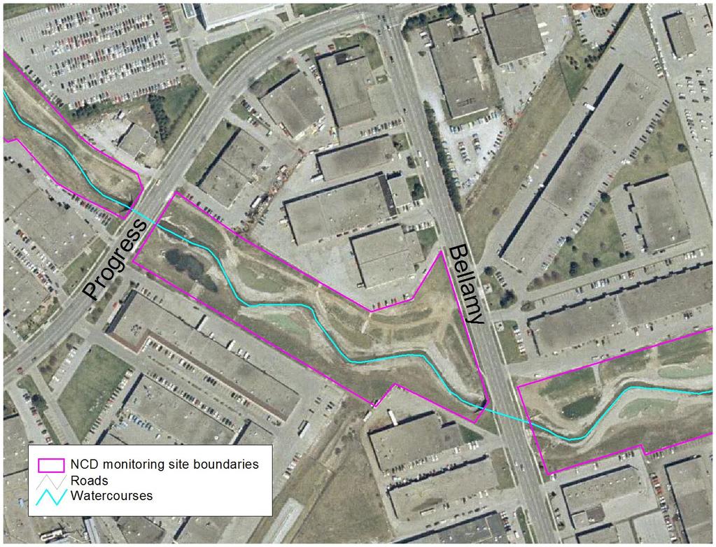
9 NCD 5 Highland Creek, Toronto Constructed in 1997; 2 nd order stream; bankfull discharge of 2.5 m 3 /s Fully urban u/s drainage area with no SWM controls; 1800 m length, 60 m valley width Design objectives: Renaturalize straightened, Constructed in hardened channel and reconnect with floodplain; Appropriate aquatic and terrestrial habitats; Enhance aesthetics. Design features: Removal of gabions, add rock vortex weirs, plunge pools, crib walls, riparian wetlands, tree and shrub plantings.


10 Geomorphic objectives Most vortex weirs found to be functioning (2006) but some becoming buried by sediments or removed by high flows; Crib walls and flow deflectors generally performing as intended; Channel is still in-transition (degradation; widening) and will continue to undergo adjustments; Some outflanking of the constructed channel into riparian wetlands and formation of islands.
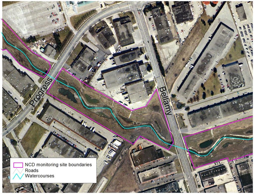
11 1999 (2 years post-construction)
12 2002 (5 years post-construction)
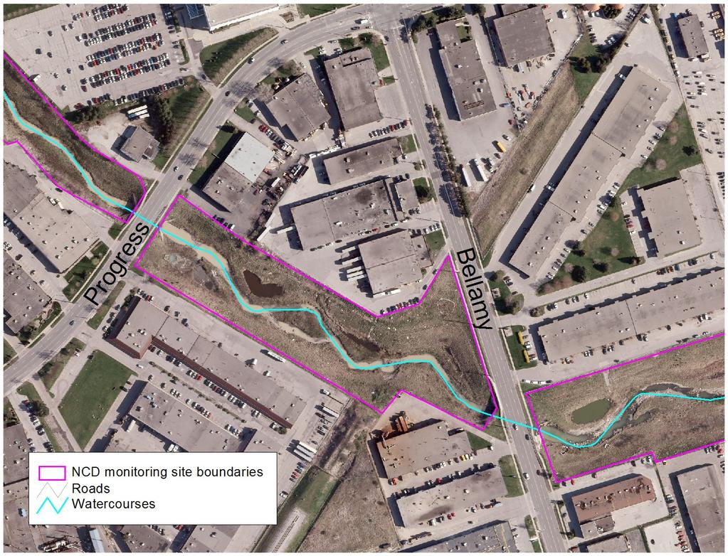
13 2007 (10 years post-construction)
14 Aquatic habitat objectives % in-stream cover is high (70%), composed of flat and round rock, no macrophyte cover yet established; Cool water fish community, mostly native and generalists, similar to u/s control; Species richness, catch per unit effort (CPUE) and index of biotic integrity (IBI) all suggest mitigated reach is providing equivalent quality habitat as u/s control; BUT u/s control represents an unimproved, impaired state! Mean Species Richness
15 Aquatic habitat objectives Benthic invertebrate data indicates poor stream quality (nutrient conditions) at both mitigated and control reaches (Hilsenhof Biotic Index Family level; HBI) %Worms, %EPT, and %Insects indicate that mitigated and control reaches are impaired; CONCLUSION: While habitat of equivalent quality as u/s impaired urban control is being achieved, no improvement from impaired state has been achieved yet. Mean HBI Score Very Poor Poor Fairly Poor Fair Good Very Good Excellent


16 NCD 8 Burndenet Creek, Markham Constructed in 1999; 1 st order stream; bankfull discharge of 3.3 m 3 /s Fully urban u/s drainage area with SWM pond; 900 m length, 60 m valley width Design objectives: Lower channel to accommodate Constructed in SWM pond outlet; Restore natural channel form and function; Rosgen E6 type channel; Appropriate aquatic and terrestrial habitats; Design features: Riffles, pools, fascines, on-line wet meadows, riparian plantings (tree, shrub and grass seed mix).


17 Geomorphic objectives Very little bed variability between riffles and pools; Channel becoming choked with vegetation; Bank erosion and slumping frequently observed - fascines not working or not present; Channel may be oversized; Channel is still in-transition (aggrading; widening).
18 Aquatic habitat objectives % in-stream cover is high (90%) and entirely composed of macrophytes; Cool water fish community, mostly native and generalists, similar to d/s control; Species richness, catch per unit effort (CPUE) and index of biotic integrity (IBI) all suggest mitigated reach is NOT providing equivalent quality habitat as control reach and is NOT positively contributing to watershed average. Mean Catch Per Unit Effort
19 Mean Index of Biotic Integrity Score Very Good Good Fair Poor 9-20
20 Aquatic habitat objectives Benthic invertebrates data indicates poor stream quality (nutrient conditions) at both mitigated reach, but fairly poor to fair at control reach (Hilsenhof Biotic Index Family level; HBI) %Worms, %EPT, and %Insects indicate that mitigated and control reaches are impaired; CONCLUSION: Both fish and benthic invertebrate data suggest aquatic habitat objectives not being achieved. Mean HBI Score Very Poor Poor Fairly Poor Fair Good Very Good Excellent


21 NCD 18 Morningside Creek, Toronto Constructed in 2003; 2 nd order stream; bankfull discharge of 3.32 m 3 /s Fully urban u/s drainage area serviced by SWM ponds; 1750 m length, 8-60 m valley width; Design objectives: Constructed in Realignment; Restore form and function of stream corridor Appropriate and diverse aquatic and terrestrial habitats. Design features: Vortex weirs, rocky ramps, riparian plantings with deep rooting native grasses (prairie cord grass), high root density plants on outside meander bends.
; Vegetation becoming established in channel; Beaver")

22 Geomorphic objectives Minor outflanking of riffles observed but >50% functioning (2006); Vegetation becoming established in channel; Beaver activity contributing to the evolution of the site BUT reducing survival of tree and shrub plantings; Channel is still in-transition (degradation; widening).
23 Aquatic habitat objectives % in-stream cover is 55% and >u/s and d/s controls, predominantly macrophytes, very little wood; Cool water fish community, mostly native and generalists, similar to u/s and d/s controls; Species richness, catch per unit effort (CPUE) and index of biotic integrity (IBI) all suggest mitigated reach is providing equivalent or better quality habitat as control reaches and positively contributing to watershed average. Mean Catch Per Unit Effort
24 Mean Index of Biotic Integrity Score Very Good Good Fair Poor 9-20
25 Aquatic habitat objectives Benthic invertebrates data indicates fair to fairly poor stream quality (nutrient conditions) at both mitigated and control reaches (Hilsenhof Biotic Index Family level; HBI) %Worms, %EPT, and %Insects indicate that mitigated and control reaches are impaired; CONCLUSION: Habitat of similar quality ( good ) as urban control reaches is already being achieved! Mean HBI Score Very Poor Poor Fairly Poor Fair Good Very Good Excellent
 potential opp.")
26 Terrestrial habitat objectives At all sites, immature meadow and plantation communities dominate, with some wetlands; Invasive species are relatively few and low in population (except NCD 11; 71% of veg com.) potential opp. to control them now; Plantings were mostly native species and survival has been moderately successful; Prairie cord grass planted at NCD 18 has been very successful; Highland Creek has the highest number of ELC vegetation types (19), naturally occurring flora species (204) and flora of conservation concern (27)
, including willow flycatcher,")


27 Terrestrial habitat objectives Several breeding bird species observed that are sensitive to urban development (local rank L4), including willow flycatcher, eastern kingbird, grey catbird, northern rough-winged swallow, and swamp swallow; Willow flycatcher recorded at 7 of 10 NCD sites monitored with a total of 17 territories noted best symbolizes an NCD site! American toads, green frogs and northern leopard frogs observed (all are local rank L3). Willow flycatcher Eastern kingbird Grey catbird
28 Overall conclusions All constructed channels are still in-transition BUT very few observations of complete failure to date; Some engineered elements are not functioning at most sites and are in need of maintenance; Biological monitoring suggests positive outcomes are being achieved over the short term opportunities remain to control spread of invasive plants; Disagreement between fish and benthic invertebrate data regarding quality of aquatic habitat, BUT still early in site evolution process; NCD sites already providing habitat for breeding bird species that are sensitive to urban development.
29 Overall conclusions Future NCD projects need more clearly stated design objectives on which to base evaluations of performance; Pre-construction biological data and as-built geomorphic surveys needed to better enable project evaluation; Consistent use of defensible and recognized monitoring methods and protocols is essential for comparisons between sampling events and project sites;


30 Next steps Continuing to monitor current 10 sites until 2015; Repeating full geomorphic assessments; Opportunity to examine evolution of habitats; Initializing new sites that include pre-construction and as-built monitoring; 5 year Progress Report to be completed in early 2011; Final report to be completed in Reports available at
Table D1: WC-R1 to WC-R3 (Wilket Creek Park)
") APPENDIX D Table D1: WC-R1 to WC-R3 (Wilket Creek Park) Category of Consideration Criteria Alternative 1 Do Nothing Alternative 2 Local Improvements Alternative 3 Channel Realignment Natural Geomorphic
APPENDIX D Table D1: WC-R1 to WC-R3 (Wilket Creek Park) Category of Consideration Criteria Alternative 1 Do Nothing Alternative 2 Local Improvements Alternative 3 Channel Realignment Natural Geomorphic
Stream Restoration Proposal 2014, Plum Run Tributary West Branch
 West Chester University Digital Commons @ West Chester University Biology Student Work Biology 2014 Stream Restoration Proposal 2014, Plum Run Tributary West Branch Jesse McLaughlin West Chester University
IMPROVING OUTCOMES FOR STREAM ALTERATION PROJECTS
 IMPROVING OUTCOMES FOR STREAM ALTERATION PROJECTS Bethany Matousek Inland Lakes and Streams Program Coordinator Wetlands, Lakes and Streams Unit DEQ Water Resources Division MatousekB@Michigan.gov 517-243-6421
Urban and Suburban Stream Restoration Structures
 Urban and Suburban Stream Restoration Structures Examples, guidance, construction and long-term performance 3 Rivers Wet Weather Stream Restoration Symposium June 22, 2018 Kelly Lennon, PE Vice President
LITTLE SHADES CREEK RESTORATION PROJECT CWA Section 319(h) Nonpoint Source Implementation Grant Project Workplan #17 ADEM Contract #C
 Nonpoint Source Implementation Grant Project Workplan #17 ADEM Contract #C") LITTLE SHADES CREEK RESTORATION PROJECT CWA Section 319(h) Nonpoint Source Implementation Grant Project Workplan #17 ADEM Contract #C90593066 PARTNERS Alabama Department of Environmental Management Cawaco
LITTLE SHADES CREEK RESTORATION PROJECT CWA Section 319(h) Nonpoint Source Implementation Grant Project Workplan #17 ADEM Contract #C90593066 PARTNERS Alabama Department of Environmental Management Cawaco
NCS Design Approach. Biology/Ecology Primer. Presented by: Jack Imhof, National Biologist Trout Unlimited Canada
 NCS Design Approach Biology/Ecology Primer Presented by: Jack Imhof, National Biologist Trout Unlimited Canada Biology/Ecology Key biological principles that are applied Need to speak the same language
COMPREHENSIVE ENVIRONMENTAL IMPACT STUDY & MANAGEMENT PLAN South Albion Bolton Community Plan Employment Needs & North Hill Commercial Lands Study
 COMPREHENSIVE ENVIRONMENTAL IMPACT STUDY & MANAGEMENT PLAN South Albion Bolton Community Plan Employment Needs & North Hill Commercial Lands Study Part A Study Components Background Information Review
Jan Moryk, Project Manager, Environmental Monitoring and Data Management Section, TRCA
 Distribution of Brook Trout in the TRCA Jurisdiction and what Legislation, Policies, and Guidelines do Conservation Authorities have at their disposal to Protect Brook Trout Habitat Jan Moryk, Project
Headwater Drainage Feature Assessment:
 Prepared for: Jim Dougan, MSc Principal & Senior Ecologist DOUGAN & ASSOCIATES Ecological Consulting & Design 77 Wyndham Street South, Guelph, ON, N1E 5R3, Headwater Drainage Feature Assessment: In Support
Jan Moryk, Project Manager, Environmental Monitoring and Data Management Section, TRCA
 Distribution of Brook Trout in the TRCA Jurisdiction and what Legislation, Policies, and Guidelines do Conservation Authorities have at their disposal to Protect Brook Trout Habitat Jan Moryk, Project
Public Information Centre September 19 th, 2017
 Public Information Centre September 19 th, 2017 WELCOME! Public Information Centre for the Maple Hill Creek Rehabilitation Class Environmental Assessment Please take the time to sign our sign in sheet
Stream Assessment Form (Form 1) Unified Stream Methodology for use in Virginia
 Unified Stream Methodology for use in Virginia") Stream Assessment Form (Form 1) Unified Stream Methodology for use in Virginia Project Name For use in wadeable channels classified as intermittent or perennial Cowardin HUC Date SAR # Class. Impact/SAR
Stream Assessment Form (Form 1) Unified Stream Methodology for use in Virginia Project Name For use in wadeable channels classified as intermittent or perennial Cowardin HUC Date SAR # Class. Impact/SAR
Bluff Creek One Water
 Bluff Creek One Water The Bluff Creek Watershed has no lakes within its boundaries. As the westernmost watershed within the District, land use changes from agricultural to residential have occurred relatively
Introduction to stream assessment
 Why do stream assessment? Introduction to stream assessment Given the current condition of rivers and the heightened public interest in them, there is a significant need for the ability to determine the
Town of Aurora Stream Management Master Plan PUBLIC INFORMATION CENTRE May 1 st, 2018
 Town of Aurora Stream Management Master Plan PUBLIC INFORMATION CENTRE May 1 st, 2018 Your comments are encouraged and appreciated, as this will provide us an opportunity to address project issues and
Maitland Valley WATERSHED
 Maitland Valley WATERSHED Report Card 2018 Maitland Conservation has prepared this report card as a summary of the state of your forests, wetlands, and water resources. WHERE ARE WE? We are one of 36 Conservation
Logan River at Rendezvous Park, Channel and Floodplain Restoration: Crack Willow (Salix fragilis) Issues and Management Strategies
 Issues and Management Strategies") Logan River at Rendezvous Park, Channel and Floodplain Restoration: Crack Willow (Salix fragilis) Issues and Management Strategies Prepared May 2, 2017 by Darren Olsen, BIO-WEST, Inc. Issues Crack willow
Logan River at Rendezvous Park, Channel and Floodplain Restoration: Crack Willow (Salix fragilis) Issues and Management Strategies Prepared May 2, 2017 by Darren Olsen, BIO-WEST, Inc. Issues Crack willow
Headwater Drainage Features
 Headwater Drainage Features Their Natural Functions and an Interim Guideline for their Evaluation, Classification and Management Susan Jorgenson (CVC) & Laura Del Giudice (TRCA) Urban development within
Dr. Paul Villard Toronto and Region International Erosion Control Association March 27, 2012
 Dr. Paul Villard Toronto and Region International Erosion Control Association March 27, 2012 GEOMORPHOLOGICAL CHARACTERIZATION CREEK AND SHORELINE RESTORATION l FLUVIAL AND COASTAL HAZARD ASSESSMENT HYDRAULIC
APPENDIX G METHODOLOGY FOR EVALUATING RETROFIT OPTIONS/RETROFIT STUDIES
 APPENDIX G METHODOLOGY FOR EVALUATING RETROFIT OPTIONS/RETROFIT STUDIES G.1 Introduction Retrofitting of existing infrastructure may be required to achieve water balance, water quantity, water quality,
RIPARIAN PROTECTION. Figure 4.4. Results of the riparian health assessment (Cows and Fish 2001).
.") RIPARIAN PROTECTION A riparian area is the transition zone between aquatic and terrestrial ecosystems, where the presence of water supports the growth of water-tolerant vegetation and soils are modified
RIPARIAN PROTECTION A riparian area is the transition zone between aquatic and terrestrial ecosystems, where the presence of water supports the growth of water-tolerant vegetation and soils are modified
Watershed Hydrology: Go with the flow. Greg Jennings, PhD, PE
 Watershed Hydrology: Go with the flow Greg Jennings, PhD, PE jenningsenv@gmail.com Streams What are your CHALLENGES? Hydrology too much water Pollutants upstream and on-site Vegetation wrong plants, wrong
STREAM RESTORATION PURPOSE, PRACTICE, AND METHODS. By Marcus Rubenstein, CPESC
 STREAM RESTORATION PURPOSE, PRACTICE, AND METHODS By Marcus Rubenstein, CPESC WHAT IS STREAM RESTORATION? The return of a stream s lost natural functions, usually resulting from watershed alterations,
South St. Vrain / Hall Meadows Restoration Planning August 20, 2015
 South St. Vrain / Hall Meadows Restoration Planning August 20, 2015 Agenda Introductions Purpose & Goals of Meeting Planning Area Master Plan Restoration Planning: Cost Estimates, Grants, Scope, Timeline
Ithaca Creek Habitat Monitoring
 Ithaca Creek Habitat Monitoring My name is: Class: Date: Ithaca Creek is part of the Catchment. Today when I was walking at the creek I decided that I wanted to investigate how healthy my waterway was.
Monitoring Report #3 Kenston Lake Stream Restoration Bainbridge, Ohio
 Monitoring Report #3 Kenston Lake Stream Restoration Bainbridge, Ohio Prepared by: EnviroScience, Inc. 5070 Stow Rd Stow OH 44224 (330) 688-0111 Year Ending: December 31, 2013 I. Project Overview The following
Natural Channel Design and Dead River Case Study Stream Restoration in the Great Lakes Basin: Using In-stream Structures & Natural Channel Design
 Natural Channel Design and Dead River Case Study Stream Restoration in the Great Lakes Basin: Using In-stream Structures & Natural Channel Design January 22, 2013 S. Paige Baker, PE, MLE Presentation Outline
Lesson 2-2: Riparian Zones
 2-14 Lesson 2-2: Riparian Zones Time of Lesson: 1 hour Rationale: The purpose of this lesson is to define what a riparian zone is and link its importance for fish and other animals, and humans, and the
Gray s Creek. Gray s Creek
 Gray s Creek 1 Grades F + Forest Conditions B Wetland Conditions C - Surface Water Quality This Watershed Report Card outlines the environmental information for the Gray s Creek watershed as of 2017. The
Carp Creek 2013 Summary Report
 Monitoring Activity in the Carp River Watershed In 2012, Mississippi Valley Conservation Authority (MVCA) worked with Friends of the Carp River (FCR) on a preliminary assessment of the Carp River. This
CREEK RESTORATION/EROSION PROTECTION WORKS. General Submission Requirements
 COMPLETE APPLICATION CHECKLIST Jan 2016 CREEK RESTORATION/EROSION PROTECTION WORKS The following checklist has been compiled to assist the applicant in preparing their application for approval pursuant
WHY ARE STREAM IMPROVEMENTS NEEDED IN TENNESSEE? TENNESSEE STREAMS
 WHY ARE STREAM IMPROVEMENTS NEEDED IN TENNESSEE? TENNESSEE STREAMS Most diverse aquatic fauna in the country Majority of West TN streams are channelized 36,000 miles of degraded stream are in need of restoration
Background. AEM Tier 2 Worksheet Stream & Floodplain Management. Glossary
 AEM Tier 2 Worksheet Stream & Floodplain Management Glossary Bankfull Stage: The stage at which water starts to flow over the flood plain; the elevation of the water surface at bankfull discharge. (This
How Much Habitat Is Enough? How Much Disturbance is Too Much?
 How Much Habitat Is Enough? How Much Disturbance is Too Much? Jocelyn Sherwood Canadian Wildlife Service - Ontario January 27 th, 2017 Page 2 April 19, 2017 Page 3 April 19, 2017 Grasslands Forest Wetlands
Stream Health. Stream Bugs Our Stream Health Communicators. Upper Nottawasaga River Stream Health. NVCA Science & Stewardship
 NVCA Science & Stewardship Stream Health Upper Nottawasaga River, 2015 Stream Bugs Our Stream Health Communicators Stream bugs (benthic macroinvertebrates) are organisms that spend much or all of their
Use of WARSSS in Stream Restoration and Watershed Planning. Michigan Aquatic Restoration Conference 2015
 Use of WARSSS in Stream Restoration and Watershed Planning Michigan Aquatic Restoration Conference 2015 October 22, 2015 Use of WARSSS in Stream Restoration and Watershed Planning 1. Watershed Management
Treatment Strategies based on Stream Stratification Methodology by W. Barry Southerland Fluvial Geomorphologist, WNTSC, USDA, NRCS
 Treatment Strategies based on Stream Stratification Methodology by W. Barry Southerland Fluvial Geomorphologist, WNTSC, USDA, NRCS Cedar Creek, WA - 2005 Cedar Creek, WA - 2005 Asotin Creek, WA 2005: photo
Fish Habitat Design, Operation and Reclamation Workbook and Worksheets for Placer Mining in the Yukon Territory
 Fish Habitat Design, Operation and Reclamation Workbook and Worksheets for Placer Mining in the Yukon Territory Version 1.0 April 2008 This document is available from the Yukon Placer Secretariat, Yukon
Galveston District Stream Condition Assessment June 2013
 Determination of Compensation 5.0 Determination of Compensation Requirements (Credits) This section describes the methods and alternatives for fulfilling the Compensation Requirement (CR), representing
Fish Habitat Design, Operation and Reclamation Workbook and Worksheets for Placer Mining in the Yukon Territory
 Fish Habitat Design, Operation and Reclamation Workbook and Worksheets for Placer Mining in the Yukon Territory Version 1.3 November 2010 This document is available from: Yukon Placer Secretariat, 206B
Eco-engineering on the Edge:
 Eco-engineering on the Edge: Decision Making for Stream Restoration and Stabilization in High Profile or Risk Environments Dan Salas, Ecologist Cardno JFNew Types of Risk Physical/Structural = Property
7.0 WATER-BASED CONTROL MEASURES
 7.0 WATER-BASED CONTROL MEASURES 7.1 IDENTIFICATION AND DESCRIPTION OF CONTROL MEASURES Table 7-1 lists the water-based options being considered for implementation in the initial screening stage. Descriptions
Evaluating the Effectiveness of Natural Channel Design Projects:
 Evaluating the Effectiveness of Natural Channel Design Projects: An Introduction and Preliminary Assessment of Sites in TRCA s Jurisdiction Prepared by: 2009 Geomorphic Solutions, Sernas Group Inc. The
SECTION 10: WETLANDS PROTECTION
 SECTION 10: WETLANDS PROTECTION 10-1 INTENT AND PURPOSE A. Intent 1. The City finds that wetlands serve a variety of beneficial functions. Wetlands maintain water quality, reduce flooding and erosion,
Old Mill School Stream Restoration
 Project Overview This conceptual plan restores and stabilizes two consecutive reaches of a highly incised and unstable stream and reconnects them with the floodplain. The restoration reaches are part of
3.6 Riparian Ecosystem Wildlife
 3.6 Riparian Ecosystem Wildlife 3.6.1 Introduction and Methodology Riparian areas and associated wetlands are widely recognized for the significant and diverse roles they play in the landscape. They clean
Assessments for designing fish habitat programs and restoration. Peter B Moyle Center for Watershed Sciences University of California, Davis
 Assessments for designing fish habitat programs and restoration Peter B Moyle Center for Watershed Sciences University of California, Davis This talk Framing monitoring of aquatic systems in terms of reconciliation
Wetland Monitoring in Cranberry Marsh Through the Durham Region Coastal Wetland Monitoring Project
 Wetland Monitoring in Cranberry Marsh Through the Durham Region Coastal Wetland Monitoring Project Greg Grabas Canadian Wildlife Service Environment Canada Durham Region Coastal Wetlands Great wetlands
DIRECTIONS FOR STRATEGY DEVELOPMENT
 DIRECTIONS FOR STRATEGY DEVELOPMENT CHAPTER 9 This chapter is designed to identify issues which may be considered during the development of a watershed strategy. In the previous Don, Humber, and Rouge
Massachusetts River and Stream Crossing Standards: Technical Guidelines
 Massachusetts River and Stream Crossing Standards: Technical Guidelines August 6, 2004 INTRODUCTION As long and linear ecosystems, rivers and streams are very important for fish and other wildlife movements,
Watts Creek 2014 Summary Report
 Monitoring Activity in the City of Ottawa In 2012, Mississippi Valley Conservation Authority (MVCA) and the Friends of the Carp River (FCR) collaborated to undertake a broad scale assessment of potential
Beaver Creek Hydrology, LLC. Franklin, Tennessee
 Beaver Creek Hydrology, LLC. Franklin, Tennessee The Harpeth River Blueway Problems with Harpeth River EPA s 303(d) Listed for siltation, habitat alteration, nutrient enrichment and low dissolved oxygen
CATEGORY a protection of the natural environment, its ecosystems and biodiversity.
 29. ENVIRONMENTAL DEVELOPMENT PERMIT AREA CATEGORY a protection of the natural environment, its ecosystems and biodiversity. The requirement to obtain an environmental development permit is cited in Section
Public Information Centre No. 2 June 15, :00 8:00 pm. Valley Park Community Centre (GYM B) 970 Paramount Drive Stoney Creek
 970 Paramount Drive Stoney Creek") Public Information Centre No. 2 June 15, 2017 6:00 8:00 pm Valley Park Community Centre (GYM B) 970 Paramount Drive Stoney Creek Please complete the sign-in sheet and review display materials. The project
Public Information Centre No. 2 June 15, 2017 6:00 8:00 pm Valley Park Community Centre (GYM B) 970 Paramount Drive Stoney Creek Please complete the sign-in sheet and review display materials. The project
Rags to Riches - The RVCA Story of Science to Stewardship
 Rags to Riches - The RVCA Story of Science to Stewardship Rideau Valley Conservation Authority Eastern Ontario On Shield off Shield Large Urban population (Ottawa) Rideau Canal connecting St Lawrence to
DEVELOPING A WATERSHED IMPROVEMENT PLAN TO MEET MULTIPLE COMMUNITY OBJECTIVES IN GAINESVILLE AND HALL COUNTY, GEORGIA
 DEVELOPING A WATERSHED IMPROVEMENT PLAN TO MEET MULTIPLE COMMUNITY OBJECTIVES IN GAINESVILLE AND HALL COUNTY, GEORGIA Chrissy, Thom 1, David Dockery 2, Kevin McInturff 3, Betsy Massie 1, and Lauren Murphy
Mill Creek Restoration in Lower Merion Township. PH (610) ; FAX (610) ;
 ; FAX (610) ;") Mill Creek Restoration in Lower Merion Township Vincent L. Sortman 1 and Robert M. Lambert 2 1 Biohabitats, Inc., 15 W. Aylesbury Road, Timonium, MD 21093; PH (410) 337-3659; FAX (410) 583-5678; email:
Mill Creek Restoration in Lower Merion Township Vincent L. Sortman 1 and Robert M. Lambert 2 1 Biohabitats, Inc., 15 W. Aylesbury Road, Timonium, MD 21093; PH (410) 337-3659; FAX (410) 583-5678; email:
COTTONWOOD CREEK RECLAMATION PHASE I & II
 COTTONWOOD CREEK RECLAMATION PHASE I & II COTTONWOOD CREEK RECLAMATION Stream Stabilization Approach to Urban Runoff Quality Cherry Creek Basin Water Quality Authority The Problem The Cherry Creek Reservoir
Environmental Assessment Derry Road and Argentia Road Intersection
 Environmental Assessment Derry Road and Argentia Road Intersection Project 11-4295 City of Mississauga, Region of Peel October 15, 2014 INTRODUCTION Table of Contents Introduction... 2 Description of the
Stream Monitoring at CVC Presented by: Loveleen Clayton & Jon Nodwell
 Stream Monitoring at CVC Presented by: Loveleen Clayton & Jon Nodwell SOSMART Meeting MNR Aurora District Office March 21, 2012 Tiered Monitoring Approach Tier 1 Tier 2 Tier 3 Objective To measure the
Urban Stream Restoration Practices: An Initial Assessment
 Urban Stream Restoration Practices: An Initial Assessment Kenneth B. Brown The Center For Watershed Protection 8391 Main Street Elliot City, MD 21043 www.cwp.org Abstract Urban stream restoration projects
Urban Stream Restoration Practices: An Initial Assessment
 Urban Stream Restoration Practices: An Initial Assessment Kenneth B. Brown The Center For Watershed Protection 8391 Main Street Elliot City, MD 21043 www.cwp.org Abstract Urban stream restoration projects
Carruthers Creek Watershed Plan: Headwater Drainage Features Characterization
 Carruthers Creek Watershed Plan: Headwater Drainage Features Characterization Prepared for: Region of Durham 8/1/2017 This study was funded by the Region of Durham. Prepared by: Jan Moryk, Project Manager,
Functional Uplift Based Stream Assessment & Restoration Design
 Functional Uplift Based Stream Assessment & Restoration Design Darcy K.L. Turner Senior Environmental Scientist, Biohabitats, Inc. (dturner@biohabitats.com) Christopher A. Streb, PE Ecological Engineer,
A Holistic Approach to. Wetland Ecosystem Restoration. and Stewardship
 A Holistic Approach to Wetland Ecosystem Restoration and Stewardship East Refuge: 41.5-42.8 Weir: 43.0 m asl Weir: 43.1 m asl T6 (42.79) 42.8 43.0 42.9 42.3 42.6 Weir: 43.0 m asl 42.8 T3 (42.81) 43.0 42.9
SEV field sheets V10.3 October 2013 Stream Ecological Valuation (SEV) field sheets Site description. Current weather conditions(tick) Clear/sunny
 field sheets Site description. Current weather conditions(tick) Clear/sunny") SEV field sheets V10.3 October 2013 Stream Ecological Valuation (SEV) field sheets Site description Page 1 of 6 Date Stream name Site code Site location GPS coordin ates Easting Northing Current weather
SEV field sheets V10.3 October 2013 Stream Ecological Valuation (SEV) field sheets Site description Page 1 of 6 Date Stream name Site code Site location GPS coordin ates Easting Northing Current weather
Project Goals and Scoping
 Prepared for: Boulder County, Colorado Flood Planning & Preliminary Design Services for South St. Vrain Creek Restoration at Hall Ranch and Scoping May 24, 2016 Meeting with General Public In association
NRCS Programs and Practices for Riparian Areas in Hawaii
 NRCS Programs and Practices for Riparian Areas in Hawaii NRCS Pacific Islands Area Hawaii - State (State (PIA) Office Honolulu, Oahu) Seven field offices (Kauai, Oahu, Molokai, Maui, Hawaii) Plant Materials
OurFuture. Protecting. March Ontario Provincial Plans and Conservation Authorities
 Protecting OurFuture Ontario Provincial Plans and Conservation Authorities March 2015 Greenbelt Plan I Niagara Escarpment Plan I Growth Plan for the Greater Golden Horseshoe I Oak Ridges Moraine Conservation
Get the Rock Out: Engineered wood structures for stream restoration. Joe Berg, Doug Streaker, Matt Koozer and Kevin Nunnery Biohabitats, Inc.
 Get the Rock Out: Engineered wood structures for stream restoration Joe Berg, Doug Streaker, Matt Koozer and Kevin Nunnery Biohabitats, Inc. Examples of Wood Structures in Stream Design Root wads one of
Environmental Implementation Report (EIR) Environmental Impact Study (EIS)
 Environmental Impact Study (EIS)") Environmental Implementation Report (EIR) Environmental Impact Study (EIS) Terms of Reference 2018 1 Table of Contents 1. Introduction... 3 2. Content of an EIR/EIS... 5 2.1. Executive Summary... 5 2.2.
Environmental Implementation Report (EIR) Environmental Impact Study (EIS) Terms of Reference 2018 1 Table of Contents 1. Introduction... 3 2. Content of an EIR/EIS... 5 2.1. Executive Summary... 5 2.2.
Stream Restoration in the Urban Environment Concepts and Considerations
 Stream Restoration in the Urban Environment Concepts and Considerations The Restoration of Our Rivers; October 5, 2012 Matthew A. Van Eps, PE & Sandi J. Formica: Watershed Conservation Resource Center
CLOCA Rural & Agricultural Guide to Permits
 CLOCA Rural & Agricultural Guide to Permits Regulation of Development, Interference with Wetlands and Alterations to Shoreline and Watercourses, Ontario Regulation 42/06 April 2014 Table of contents Introduction...
A landscape perspective of stream food webs: Exploring cumulative effects and defining biotic thresholds
 A landscape perspective of stream food webs: Exploring cumulative effects and defining biotic thresholds Objectives To better understand how stream food webs are embedded in their landscapes To quantify
CITY OF GRIFFIN STREAM BANK RESTORATION PROGRAM
 CITY OF GRIFFIN STREAM BANK RESTORATION PROGRAM Lee Phillips 1, J. Erik Alford2 and M. Brad McLeod 3 AUTHORS: 'Project Engineer, Integrated Science & Engineering, 118 North Expressway, Griffin, GA 30223;
Woodward Avenue Wastewater Treatment Plant Red Hill Creek Outfall Modification Works Joint Stewardship Board City of Hamilton.
 Woodward Avenue Wastewater Treatment Plant Red Hill Creek Outfall Modification Works Joint Stewardship Board City of Hamilton June 30, 2015 Presentation Outline 1. Background 2. Environmental Assessment
CVC & TRCA Water Balance Guidelines for the Protection of Natural Features
 CVC & TRCA Water Balance Guidelines for the Protection of Natural Features Scott Sampson, CVC Supervisor Natural Heritage Program Laura Del Giudice, TRCA Senior Planning Ecologist April 26, 2012 Outline
Session B4- Freshwater fish and aquatic macroinvertebrate biomonitoring of the Eel River Headwaters Restoration sites in Plymouth, Massachusetts
 University of Massachusetts - Amherst ScholarWorks@UMass Amherst International Conference on Engineering and Ecohydrology for Fish Passage International Conference on Engineering and Ecohydrology for Fish
2.4 Floodplain Restoration Principles
 Floodplain Restoration Principles 2.4 Floodplain Restoration Principles Anthropogenic alternation of river corridors and floodplains significantly modified the structure and function of landscapes and
Wetland restoration and monitoring on the Chevelon Wildlife Area
 Wetland restoration and monitoring on the Chevelon Wildlife Area Michael Ingraldi, Ph.D. Research Branch Arizona Game and Fish Department Phoenix, Arizona 85023 The Chevelon State Wildlife Area is located
Watershed. Rigaud River Report Card. Grades: Forest Conditions Wetland Conditions Surface Water Quality
 Watershed Report ard Grades: + onditions Wetland onditions Surface Water Quality This Watershed Report ard outlines the environmental information for the watershed as of 2006. The information provides
How does sediment affect fish and macroinvertebrates?
 How does sediment affect fish and macroinvertebrates? How does sediment affect fish and macroinvertebrates? Suspended sediment (TSS): breathing, vision Sediment on streambed: egg development living space
* For applicants utilizing bank for compensatory mitigation requirements, information below is not applicable.
 Mitigation Plan (33 CFR 332.4(c)/40 CFR 230.92.4(c)) A mitigation plan is required for all forms of compensatory mitigation, whether permittee-responsible mitigation, mitigation banks, or in-lieu fee mitigation
RIPARIAN AREAS REGULATION
 Definitions and interpretation RIPARIAN AREAS REGULATION 1 (1) In this regulation: Act means the Fish Protection Act; active floodplain means an area of land that supports floodplain plant species and
Watershed Investigations: How to Assess the Health of a Stream
 Watershed Investigations: How to Assess the Health of a Stream By Joan Chadde, Western UP Center for Science, Mathematics & Environmental Education. All photos by author, unless otherwise noted. Why Monitor
Step-Pool Creation to Restore Fish Passage and Riparian Health
 Step-Pool Creation to Restore Fish Passage and Riparian Health Jenny Kindig Water Resources Engineer Denny Mengel, Senior Environmental Scientist Steve Miller, Water Resources Engineer Gloria Beattie,
UNDERGROUND UTILITY CROSSING (TRENCHLESS) General Submission Requirements
 General Submission Requirements") COMPLETE APPLICATION CHECKLIST Jan 2016 UNDERGROUND UTILITY CROSSING (TRENCHLESS) The following checklist has been compiled to assist the applicant in preparing their application for approval pursuant
COMPLETE APPLICATION CHECKLIST Jan 2016 UNDERGROUND UTILITY CROSSING (TRENCHLESS) The following checklist has been compiled to assist the applicant in preparing their application for approval pursuant
5A Consider Approval of 60% Design Plans for 2017 Plymouth Creek Stream Restoration Project, Plymouth (CIP 2017CR-P)
") Memorandum Subject: Item 5A Consider Approval of 60% Design Plans for 2017 Plymouth Creek Stream Restoration Project, Plymouth (CIP 2017CR-P) Project: 23270051 2017 635 5A Consider Approval of 60% Design
Memorandum Subject: Item 5A Consider Approval of 60% Design Plans for 2017 Plymouth Creek Stream Restoration Project, Plymouth (CIP 2017CR-P) Project: 23270051 2017 635 5A Consider Approval of 60% Design
Ten Principles of River Restoration and Four River Project of Korea
 Ten Principles of River Restoration and Four River Project of Korea Randolph T. Hester, G. Mathias Kondolf, Marcia McNally, Department of Landscape Architecture and Environmental Planning University of
2002 Rodeo-Chediski Wildfire Survival of Springs. Daniel Pusher, White Mountain Apache Tribe Water Resources Program
 2002 Rodeo-Chediski Wildfire Survival of Springs Daniel Pusher, White Mountain Apache Tribe Water Resources Program PURPOSE Emphasize importance of watershed protection & preservation: Identification Reconnaissance
Enhancing Straightened River Channels
 .6 Creating a sinuous low flow channel in an over-widened river River Dearne Location - Mexborough, West of Doncaster, South Yorkshire SE484012 Date of construction - Summer 1995 Length - 500m Cost - 4,000
Amphibian Protection Strategies. Presented by: Linda Dupuis, M.Sc., R.P.Bio Wildlife Habitat Ecologist
 Amphibian Protection Strategies Presented by: Linda Dupuis, M.Sc., R.P.Bio Wildlife Habitat Ecologist Vulnerability Biphase life histories and physiological limitations make aquatic-breeding amphibians
Riparian Ecology Station OBJECTIVES
 Riparian Ecology Station OBJECTIVES Students learn The basic definition of a riparian area. The condition of any riparian area greatly affects the water quality and aquatic habitat of the water body it
Restoring Ecological & Geomorphic Function on the Heartrock Ranch
 Restoring Ecological & Geomorphic Function on the Heartrock Ranch DAVE ROSGEN BRANDON ROSGEN WILDLAND HYDROLOGY FORT COLLINS, COLORADO RIVER RESTORATION 2018, TWO HARBORS, MN OCTOBER 29 TH, 2018 Cooperators
TOWN OF WINDSOR, CONNECTICUT INLAND WETLANDS & WATERCOURSES COMMISSION. 1. APPLICANT Name: Phone: Address: Cell:
 TOWN OF WINDSOR, CONNECTICUT INLAND WETLANDS & WATERCOURSES COMMISSION This application form is intended to expedite the work of the Town Staff, the Town Inland Wetlands and Watercourses Commission, and
I-3 THE IMPERVIOUS COVER MODEL
 I-3 THE IMPERVIOUS COVER MODEL AT A GLANCE Imperviousness is a metric that represents the sum of roads, parking lots, sidewalks, rooftops, and other impermeable surfaces that prevents water from infiltrating
Chapter Three: Discussion and Conclusion. 3.1 Introduction/Overview. 3.2 Countywide Stream Assessment
 3.1 Introduction/Overview The objective of this study was to develop a stream prioritization tool that evaluates stream reaches in terms of the potential water quality improvements that could be achieved
H ollow R iver. Stewardship Works! S ubwatershed. Grades. Land Water Wetlands Biodiversity. Not Stressed Not Stressed Not Stressed Vulnerable
 s H ollow R iver Land Water Wetlands Biodiversity S ubwatershed T he Hollow River Subwatershed is 40,863 hectares in size and lies predominantly in the Township of Algonquin Highlands in Haliburton County.
Preface. MNR # Queen s Printer for Ontario, 2012 ISBN (PRINT) ISBN (PDF)
 ISBN (PDF)") Preface In 2008, the inter-agency Drainage Act & Section 28 Regulations Team (DART) was established by the Ministry of Natural Resources (MNR) and the Ministry of Agriculture, Food and Rural Affairs (OMAFRA)
Preface In 2008, the inter-agency Drainage Act & Section 28 Regulations Team (DART) was established by the Ministry of Natural Resources (MNR) and the Ministry of Agriculture, Food and Rural Affairs (OMAFRA)
WATERSHED. Maitland Valley. Report Card 201
 Maitland Valley WATERSHED Report Card 201 The Maitland Valley Conservation Authority has prepared this report card as a summary on the state of our forests, wetlands, surface water, and ground water resources.