Unmanned Aircraft for GIS
|
|
|
- Ethan Higgins
- 6 years ago
- Views:
Transcription

1 Unmanned Aircraft for GIS Fred Judson, GISP UAS Program Director For Documents


2 How It Began (For Me) Slide From 2013 Formalization of GIS in the district. Implementation of Dynamic Temporal Webmapping. Development of advanced GPS asset data collection and management software. National GIS for Strategic Asset Manageme nt group Governme nt Should Look Beyond - Gartner Research Unmanned Aircraft Systems for mapping of existing roadway assets, conditions and contractor complyancy Start of Asset Data Collection Information and Management System (ADCIMS) Construction GPS implementation through innovative constructron contracts for contractor complyancy and asset management Advanced Asset collection through webbased video log software.?

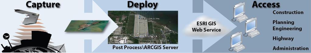
3 ODOT UAS Implementation


4 ODOT UAS Implementation Military's X-47B SenseFly Swinglet CAM Actual Size Compared to the X- 47B For Bombing For Mapping and Photogrammetry Operations


5 ODOT UAS Implementation

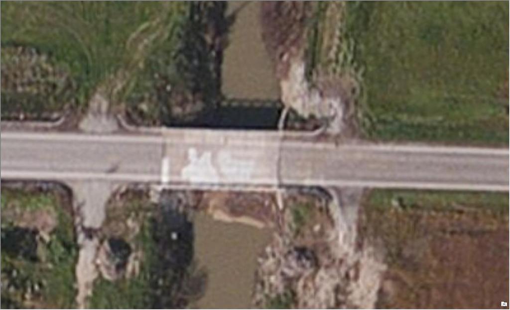


6 UAS High Resolution Aerial Photography

7 Natural Disaster Response Ohio s 1 st Emergency COA


8 OH/IN UAS Center & Test Complex Mission Promote UAS in Ohio and Indiana Enabling Flight 18 Active COAs 23 Approved COAs 20 In Various Review Stages 10 Aerostat Waivers Section 333 Activities Vibrant Response Assisted Penn State Police Guardian Shield Performed over 150 flights last year Participating in FAA COE with OSU FAA/AFRL Ground Based Sense and Avoid

9 OH/IN UAS Center & Test Complex - Services Operations Experience Business Requirement Study Operations Analysis Airspace Analysis Crew Qualifications COA/333 Preparation/Submission UAS Research Independent Safety Review Board Flight Readiness Review Flight Operations FAA Reporting Data Processing


10 Flight Operations Flight Public COA Section 333 Civil COA

11 UAS Activities Newest 333 Are Mostly Standardized 1120 Approved Airframes Companies with 333 s Ohio 105 Indiana 58 Registered UAS for Commercial Use Ohio 77 39% DJI 38% Government Indiana 59

")


12 Manual UAS Autonomous Drone Technology Automated Flight (Automatous) Human- Operated Human- Delegated Human- Supervised Human- On-The- Loop Human- Out-Of- The-Loop
13 UAS for Mapping One of drones many boons is to democratize the process of mapmaking. They are far cheaper than the mapmaking technologies they replace. Enables end users Disrupts Traditional Services Name Platform Software Sensor AGL Accuracy Findings Date Baseline Surveys Ltd. C-Astral Bramor Agisoft Photoscan Sony Nex-7 300' Accuracy 95%, 1.6" horizontal, 2.7" vertical Sept Institute for Sustainable Agriculture MD Agisoft Photoscan Olympus PEN E- PM1 100'- 200' Mean accuracy between 77%-90% Horizontal Mar-14 PIX4D and Helimap Systems Swinglet Cam Socet GXP and Pix4D Canon Ixus 120IS 500' 0.4"-0.59" Horizontal, 0.39" vertical and RMSE 0.04 to 0.07 Sep-11 Canon Digital TU Berlin HiSystems MK Okto Bundler, PMVS2, Photoscan Ixus 100 IS 165' Absolute point cloud deviation= 0.78" 2011 Canon 550D digital 100- Univ. Tasmania TerraLuma UAV Opensource and Custom/MVS (Multiview stereopsis) SLR camera 165' ±0.67" (but never more than 1.02" horizontal, 1.57" vertical) May-12


14 UAS for Mapping Drone Services Low Cost of Entry Job Cost Biased on Risk Geospatial Services Diversity of Services Data Processing Techniques End Users Lowest Cost of Entry Subject Matter Experts Common Factors All Own Drones and Perform Operations at Different Levels Differentiated On Risk Culverts Small Bridges Intersections High Traffic Areas Low Risk End User Geospatial Service Providers Drone Services High Risk


15 Humanitarian Response UAVs Establish clear standards for the responsible use of UAVs Document lessons learned and best practices Provide hands-on UAV training Inform UAV deployments Catalyze research & information sharing By lowering the cost and complexity of aerial mapping property rights, drones can literally put entire communities on the map, enabling them to be counted and formalized so that they can assert their rights and determine their own destinies. New America, Drones and Aerial Observation


16 Structure Investigation What We Want Remove Some Risk Perform Our Tasks Efficiently Provide Added Value Current Issues Regulations Non-participants BLOVS Platform Limitations Sensors Avoidance and GPS Power and Quality Weather Human Perception What We Can Get High Resolution Imagery Typically Difficult to Acquire 3D Modeling Thermal Loading Concrete Delamination
17 UAS for Mapping Potential UAV application areas in surveying tasks Sebastian Siebert, Jochen Teizer Mobile 3D mapping for surveying earthwork projects using an Unmanned Aerial Vehicle (UAV) system Automation in Construction, Volume 41, 2014, j.autcon Name Platform Software Sensor AGL Accuracy Findings Date Baseline Surveys Ltd. C-Astral Bramor Agisoft Photoscan Sony Nex-7 300' Accuracy 95%, 1.6" horizontal, 2.7" vertical Sept Institute for Sustainable Agriculture MD Agisoft Photoscan Olympus PEN E- PM1 100'- 200' Mean accuracy between 77%-90% Horizontal Mar-14 PIX4D and Helimap Systems Swinglet Cam Socet GXP and Pix4D Canon Ixus 120IS 500' 0.4"-0.59" Horizontal, 0.39" vertical and RMSE 0.04 to 0.07 Sep-11 Canon Digital TU Berlin HiSystems MK Okto Bundler, PMVS2, Photoscan Ixus 100 IS 165' Absolute point cloud deviation= 0.78" 2011 Canon 550D digital 100- Univ. Tasmania TerraLuma UAV Opensource and Custom/MVS (Multiview stereopsis) SLR camera 165' ±0.67" (but never more than 1.02" horizontal, 1.57" vertical) May-12
 Inpho UASMaster (Trimble) Postflight Terra 3D (Sensefly +Pix4D) APS 3D Mapping Suite (Sensefly+Menci)")
 Correlator 3D EnsoMOSAIC DroneMaper Mapping/Flight Operations Tips Slow Shutter Speed Unstable Platform")


18 Pix4D Mapper Pro Agisoft Photoscan Pro ERDAS IMAGINE Pro GeoApp.UAS (Hexagon Geospatial) Inpho UASMaster (Trimble) Postflight Terra 3D (Sensefly +Pix4D) APS 3D Mapping Suite (Sensefly+Menci) ICE: Image Composite Editor (Microsoft) 2D3 (Catalina) GeoApp.UAS (HexagonGeospatial) Correlator 3D EnsoMOSAIC DroneMaper Mapping/Flight Operations Tips Slow Shutter Speed Unstable Platform Camera Resolution Things in Motion Trees (Wind), Water etc. Little or no Texture Sand, Snow Repeating Texture Forest, Farm Fields Lighting Changes Clouds or Time of Day Not Enough Overlap Different Software Processing Packages Aerial Imagery Low altitude causes greater perspective change causing more post processing to make it look right for things that protrude from the ground. Ability/ Feature Orthomosaic X X X X X X X X X X X Point Cloud X X X X X X X X X X Generation Mesh X X X X Modeling Texture X X X X X Generation Terrestrial X X X X X X X X X X X X Data Aerial Data X X X X X X X X X X X X D D D D D D D C C C C esktop/cloud

19 The Future


20 Drone Diversity

21 Beyond The Orthophoto


22 Questions Fred Judson, GISP UAS Program Director oh.us Updates: Airframes Approved 9 Day approval times for 333 On-line registrations for commercial UAS Blanket COA raised to 400 On target for 06/17/16
Asset Management Implementations within the Ohio Department of Transportation
 Ohio Department of Transportation John R. Kasich, Governor Jerry Wray, Director Asset Management Implementations within the Ohio Department of Transportation 2012-9th National Conference on Transportation
Mapping with Drones. Key Considerations and Factors to Achieve Desired Accuracy
 JUNE 2017 Mapping with Drones Key Considerations and Factors to Achieve Desired Accuracy 2 Presentation Format 1. Introduction DroneView Technologies 2. Market Focus 2015 through Today 3. Outlook for 2017
Drone Surveying: The Complete Story
 Drone Surveying: The Complete Story NYSAPLS Friday Webinar Series December 1, 2017 Aerotas enables surveyors to map by drone More than: 60 clients, 600 drone surveys, 450 hours of field testing & training,
LOW COST AERIAL MAPPING WITH CONSUMER-GRADE DRONES
 LOW COST AERIAL MAPPING WITH CONSUMER-GRADE DRONES S.L. Madawalagama 1, N. Munasinghe 2, S.D.P.J.Dampegama 3, L. Samarakoon 1 1 Geoinformatics Centre (GIC), Asian Institute of Technology (AIT), PO Box
Cartographic Potential of New Technologies: Aerial Data Collection
 Old Dominion University ODU Digital Commons September 29, 2016: Adaptive Structures and Innovative Solutions Hampton Roads Sea Level Rise/Flooding Adaptation Forum 9-29-2016 Cartographic Potential of New
OCWR DRONE PROGRAM LEA Technical Training Series December 4, 2018
 OCWR DRONE PROGRAM 2018 LEA Technical Training Series December 4, 2018 2 ENTERING THE DANGER ZONE 3 OVERVIEW History of OCWR s Drone Operations Upgrades in Drone Technology FAA Operating Rules FAA Remote
Drones in the Solid Waste Industry
 1 Drones in the Solid Waste Industry Sam Marchant December 4, 2018 Presented By: Sam Marchant, E.I.T. Bachelor of Science in Civil Engineering from Cal Poly, San Luis Obispo Assists in improving efficiency
Drones Use in Forestry: Regulations, Applications, Considerations
 Drones Use in Forestry: Regulations, Applications, Considerations Regulations What is a Drone? Small unmanned aircraft system aka UAV, UAS, suas. Weight is greater than 0.5 lbs. and less than 55 lbs. including
Unmanned Aircraft Transmission Line Maintenance Technology
 Unmanned Aircraft Transmission Line Maintenance Technology RMEL s Transmission Planning and Operations Conference March 14 th -15 th 2018 Dusty Birge UAV Recon Ft. Collins, CO - Solutions Provider www.uav-recon.com
Enhancing the Value of Precision Ag Data with Unmanned Aerial Systems (UASs) Mike Buschermohle Precision Ag Specialist UT Extension
 Mike Buschermohle Precision Ag Specialist UT Extension") Enhancing the Value of Precision Ag Data with Unmanned Aerial Systems (UASs) Mike Buschermohle Precision Ag Specialist UT Extension Unmanned Aerial Systems (UASs) Current FAA Regulations UASs UAV, cameras,
Enhancing the Value of Precision Ag Data with Unmanned Aerial Systems (UASs) Mike Buschermohle Precision Ag Specialist UT Extension Unmanned Aerial Systems (UASs) Current FAA Regulations UASs UAV, cameras,
2016 AASHTO Subcommittee on TSM&O
 2016 AASHTO Subcommittee on TSM&O New Technology Trends for Transportation Unmanned Aerial Systems (UAS) for Transportation Purposes Steven J. Cook, P.E. Engineer of Operations & Maintenance Michigan Department
2017 NMARC/ASMCRA. Take to the Skies: Using Drone Technology as a Tool
 2017 NMARC/ASMCRA Take to the Skies: Using Drone Technology as a Tool Unmanned Aerial Systems (UAS) for Transportation Purposes Hilary Owen, P.E. Systems Operations Engineer Michigan Department of Transportation
The professional mapping tool
 The professional mapping tool The ebee is the easiest-to-use, fully autonomous mini-drone on the market. Our drone is a turn-key solution and includes all the accessories required for operation, as well
AERIAL INSPECTIONS USING UNMANNED AERIAL VEHICLES
 AERIAL INSPECTIONS USING UNMANNED AERIAL VEHICLES MICHAEL A. PEREZ, WESLEY C. ZECH, PH.D., WESLEY N. DONALD, PH.D. MRN/SWANA MID-ATLANTIC A N N UA L C ONFERENCE ELLICOTT CITY, MD JUNE 22, 2016 Research
Mapping on a Budget. Using Drones & Digital Data. Jeff Campbell
 Mapping on a Budget Using Drones & Digital Data Jeff Campbell 1 Mapping with Minimal Investment UAS Mapping suited to Incremental Approach Large Up front investment not necessary. Determine if you have
$ / maximum area Imagery $10-20 No limit $<1-3. $ / minimum area
 Technical Note Forest Industry Applications of UAVs 20 July 2017 Authors: Dr Grant Pearse *, Dr Michael Watt. * Corresponding author: grant.pearse@scionresearch.com Summary A recent project at Scion explored
ASSESSING THE STRUCTURE OF DEGRADED FOREST USING UAV
 ASSESSING THE STRUCTURE OF DEGRADED FOREST USING UAV STUDY CASE IN YUNGAS CLOUD FOREST, NORTH ARGENTINA Fernando Rossi 1, Andreas Fritz 2, Gero Becker 1, Barbara Koch 2 Albert-Ludwigs-Universität Freiburg
SURVEYING CONSTRUCTION FORESTRY AGRICULTURE ENVIRONMENT POWER ENGINEERING
 UAV BIRDIE SURVEYING CONSTRUCTION FORESTRY AGRICULTURE ENVIRONMENT POWER ENGINEERING BIRDIE YOUR TAILOR-MADE UAV Dedicated to surveying and agriculture, UAV BIRDIE is a well-tailored drone, combining intuitive
Flying High. Typical methods
 1 Flying High MicroUAV (Unmanned Air Vehicles) Applications for Public Works APWA National Congress San Antonio, Texas September 2007 Mike Harrell, P.E. Senior Engineer mharrell@ara.com www.ara.com (p)
3D Reconstruction Optimization Using Imagery Captured By Unmanned Aerial Vehicles
 3D Reconstruction Optimization Using Imagery Captured By Unmanned Aerial Vehicles Abby Bassie, Sean Meacham, David Young, Gray Turnage, and Robert J. Moorhead Geosystems Research Institute, Mississippi
Drones in Forestry: Regulations, Applications, and Considerations SESAF Conference Darian Yawn Paul Shepard
 Drones in Forestry: Regulations, Applications, and Considerations 2018 SESAF Conference Darian Yawn Paul Shepard About LMSS Forest Technology Solutions Provider Sales, Training, and Support Project Consulting,
Automating Your Monitoring with the Latest suas Technology. Harry White, Forest Ecologist, Colebrook, CT
 Automating Your Monitoring with the Latest suas Technology Harry White, Forest Ecologist, Colebrook, CT Primary Uses: Annual Property Monitoring Easement and Fee Inspections Big-Block Challenges Stewardship
FSBPA Chip Baumberger, Project Scientist Dustin Myers, UAV Coordinator Brent Gore, GIS Coordinator
 FSBPA 2018 Practical applications of drones (UAVs) for aerial mapping of beach and nearshore habitats & comparison to full-scale manned aircraft using GIS-based hardbottom classification Chip Baumberger,
Unmanned Aerial Vehicle (UAV) Inspection, survey, mapping, modelling & analysis
 Inspection, survey, mapping, modelling & analysis") Unmanned Aerial Vehicle (UAV) Inspection, survey, mapping, modelling & analysis Opus have utilised our own UAV fleet since 2007. They are one of a range of technologies used to enhance our core services.
Unmanned Aerial Vehicle (UAV) Inspection, survey, mapping, modelling & analysis Opus have utilised our own UAV fleet since 2007. They are one of a range of technologies used to enhance our core services.
Unmanned Aerial Vehicles in Municipality Level 3D Topographic Data Production in Urban Areas
 Unmanned Aerial Vehicles in Municipality Level 3D Topographic Data Production in Urban Areas Olli NEVALAINEN, Tomi ROSNELL, Teemu HAKALA, Eija HONKAVAARA, Roope NÄSI, Kimmo NURMINEN, Finland Key words:
Unmanned Aerial Systems
 2016 Southern Consultants Meeting Unmanned Aerial Systems How UAV s Are Helping Us Become More Profitable and Better Stewards of the Land Christian Brodbeck February 25, 2016 Information drives agriculture
Applications for Unmanned Aerial Vehicles (UAVs) in Electric Utility Construction Cross Border Meeting Cartagena, Columbia March 17, 2016
 in Electric Utility Construction Cross Border Meeting Cartagena, Columbia March 17, 2016") Applications for Unmanned Aerial Vehicles (UAVs) in Electric Utility Construction Cross Border Meeting Cartagena, Columbia March 17, 2016 UAV Benefits to the Industry Up-close inspections of energized
Applications for Unmanned Aerial Vehicles (UAVs) in Electric Utility Construction Cross Border Meeting Cartagena, Columbia March 17, 2016 UAV Benefits to the Industry Up-close inspections of energized
Drone Basics 101 Technology, Regulations and Project Examples. Tom Gehrdes & Alton Whittle
 Drone Basics 101 Technology, Regulations and Project Examples Tom Gehrdes & Alton Whittle What are UAVs? Unmanned Aerial Vehicles (UAVs) are remotely operated aircraft that fly without the possibility
A major real estate developer in India approached us, looking to enhance their productivity, for a 30 acre construction site.
 A major real estate developer in India approached us, looking to enhance their productivity, for a 30 acre construction site. They wanted aerial videos of construction progress on a regular basis to help
Research with UASs in the Eel River Watershed
 Research with UASs in the Eel River Watershed Jim Graham Eel River Forum June 8 th, 2016 Photo by Chris Muhl Terminology Drones: Military UAV: Unmanned Aerial Vehicle UAS Unmanned Aerial System Preferred
sensefly Inspection 360 More insights, less risk
 sensefly Inspection 360 More insights, less risk sensefly and Pix4D offer a turnkey solution from take-off to the final 3D model which I would recommend. It avoids wasting time, plus you benefit from customer
Artificial Intelligence applied for electrical grid inspection using drones
 Artificial Intelligence applied for electrical grid inspection using drones 11/08/2018-10.22 am Asset management Grid reliability & efficiency Network management Software Drones are being used for overhead
UNMANNED AERIAL VEHICLE SYSTEMS
 UNMANNED AERIAL VEHICLE SYSTEMS UNMANNED AERIAL VEHICLE SYSTEMS INTRODUCTION UAV SYSTEMS APPLICATIONS LEGISLATION SAFETY CONSIDERATIONS HOW TO SELECT A COMPETENT SUPPLIER OF UAV SERVICES Q&A One of Europe's
USING UNMANNED AERIAL VEHICLES USING UNMANNED AERIAL VEHICLES
 LAND GEOSPATIAL SERVICES SERVICES LAND SURVEY SURVEY AND AND GEOSPATIAL USING UNMANNED AERIAL VEHICLES USING UNMANNED AERIAL VEHICLES AE R I AL IINSPECTION N S P E CT I O N AND AN D SURVEYING S U R V E
Low Cost Aerial Mapping Alternatives for Natural Disasters in the Caribbean
 Low Cost Aerial Mapping Alternatives for Natural Disasters in the Caribbean Raid Al-Tahir, Marcus Arthur, and Dexter Davis The University of the West Indies, Trinidad and Tobago Presentation Outline: The
Aerial Thermal and Visual Inspection of Electric Lines with an Unmanned Aerial System Brandon Rench, CP
 2018 Aerial Thermal and Visual Inspection of Electric Lines with an Unmanned Aerial System Brandon EXECUTIVE SUMMARY Our client has 770 miles of electric Distribution and Transmission lines which provide
Unmanned systems for offshore areas: what is available and what is needed. by William Koski
 Unmanned systems for offshore areas: what is available and what is needed by William Koski The Need Offshore areas are sometimes hazardous to conduct aerial and water based studies because: weather can
II. Presentation of the Project
 I. Introduction The Royal Canadian Mounted Police started using Unmanned Aerial Vehicles to help with their work on collision and crime scene investigations. It allows the investigations to be conducted
Superior. Drone. Solutions. CASE STUDY. Improving Infrastructure Damage Assessment using Drones.
 Superior. Drone. Solutions. CASE STUDY Improving Infrastructure Damage Assessment using Drones www.aerialapplications.com EXECUTIVE SUMMARY In the wake of Hurricane Matthew in October of 2016, Aerial Applications
P310 VTOL UAV CHC P310 VTOL UAV. Zhen Yann Zhen Yann - UAV Product Manager UAV Product Manager Shanghai, 15 February,2017 Shanghai - Feburary 15, 2017
 P310 VTOL UAV CHC P310 VTOL UAV Zhen Yann Zhen Yann - UAV Product Manager UAV Product Manager Shanghai, 15 February,2017 Shanghai - Feburary 15, 2017 1 CHC Profile 2 CHC VTOL UAV Introduction 3 4 CHC VTOL
Unmanned Aerial Vehicles as Data Mules for Reconnaissance and Environmental Monitoring
 Unmanned Aerial Vehicles as Data Mules for Reconnaissance and Environmental Monitoring - Srikanth Saripalli http://robotics.asu.edu srikanth.saripalli@asu.edu ARIZONA STATE UNIVERSITY / SCHOOL OF EARTH
Michigan Department of Transportation
 Evaluating the Use of Unmanned Aerial Systems (UAS) for Transportation Purposes Michigan Department of Transportation Steven J. Cook, P.E. Engineer of Operations & Maintenance UAS Benefits for Transportation
CASE STUDY: POWER ENGINEERS
 CASE STUDY: POWER ENGINEERS How An Engineering Consulting Firm Saved Money, Increased Efficiency, and Preserved Sensitive Wildlife Using Drones POWER Engineers is an employeeowned consulting services and
Stability Operations & Humanitarian Assistance & Other Non-Traditional UAS. Craig A. Woolsey Aerospace & Ocean Engineering Virginia Tech
 Stability Operations & Humanitarian Assistance & Other Non-Traditional UAS Craig A. Woolsey Aerospace & Ocean Engineering Virginia Tech * quest.nasa.gov Stability Operations in Systems Theory Stability
Utilization of Unmanned System Technology in Transportation Engineering
 Utilization of Unmanned System Technology in Transportation Engineering Dr. Michael R. Williamson Assistant Professor Indiana State University Sam Morgan Instructor Indiana State University Overview Parking
Potential for Using Unmanned Aerial Vehicles (UAV) in an On-Site Inspection
 in an On-Site Inspection") Potential for Using Unmanned Aerial Vehicles (UAV) in an On-Site Inspection Dr James Palmer AWE plc, UK CTBTO Science and Technology Conference 2015 T3.2-06 What is an Unmanned Aerial Vehicle? Different
Potential for Using Unmanned Aerial Vehicles (UAV) in an On-Site Inspection Dr James Palmer AWE plc, UK CTBTO Science and Technology Conference 2015 T3.2-06 What is an Unmanned Aerial Vehicle? Different
Drones Interest Group Members
 About the GSMA Drones Interest Group Members GSMA Position on Drones GSMA have created a policy position, on behalf of the mobile industry, to explain to policy makers and regulators the benefits of using
BNSF UAS PROGRAM. Proprietary Information Patent Pending
 BNSF UAS PROGRAM Proprietary Information Patent Pending 1 Concept of Operations 1/27/2018 Proprietary Information Patent Pending 2 BNSF UAS Program Timeline Pilot Program Launched Proof of Concept Flights
Hitachi Drone Platform Contributes to Urban Development
 FEATURED ARTICLES Public and Social Infrastructure for Safe and Pleasant Cities Hitachi Drone Platform Contributes to Urban Development As the shortage of workers due to the aging population and falling
Drones and Their Role in Agriculture. Mike Buschermohle Precision Ag Specialist UT Extension
 Drones and Their Role in Agriculture Mike Buschermohle Precision Ag Specialist UT Extension Current FAA Regulatory Environment Public UASs can fly under a Certificate of Authorization (COA). Government
Precision Agriculture Methods & Cranberry Crop Monitoring with Drones
 Precision Agriculture Methods & Cranberry Crop Monitoring with Drones Presented by: Mike Morellato, M.Sc., GISP Owner, Crop Sensors Remote Sensing and Agriculture Longer history than many realize.of identifying,
A Seismic approach with UAV technologies
 A Seismic approach with UAV technologies Unmanned aircraft technology is being used in many applications across many industries. The benefits of having a bird s eye view in Seismic Exploration are limitless.
Amazon Prime Air. sensefly PRECISION HAWK. Carinthia University of Applied Sciences Austria. Unmanned Aerial Systems II. Group I
 Carinthia University of Applied Sciences Austria Unmanned Aerial Systems II sensefly PRECISION HAWK Amazon Prime Air Group I Dilshod Ikramov Agne Valukonyte Rustam Miyliyev 1. Introduction 2. Companies:
UAS-Platforms for Research, Phenotyping and Precision Management
 UAS-Platforms for Research, Phenotyping and Precision Management Juan Landivar (1), Murilo Maeda (1), Josh McGinty (2), Jinha Jung (3), Anjin Chang (3), Juan Enciso (4), Andrea Maeda (1) (1)Texas A&M AgriLife
OH/IN UAS Center. Overall mission of the UAS Center : Create, Collaborate, and Fly
 OH/IN Center The OH/IN Center is a collaboration between the states of Ohio and Indiana established in 2013 by Governors John Kasich and Mike Pence Overall mission of the Center : Create, Collaborate,
Development and Applications of Unmanned Aerial Vehicles: Challenges and Opportunities
 Development and Applications of Unmanned Aerial Vehicles: Challenges and Opportunities Yanbo Huang Research Ag Engineer, Lead Scientist, USDA-ARS Adjunct Professor, Texas A&M University, Mississippi State
Mapping and Surveying. Reality Modeling for Going Digital Strategy
 IMAGE COURTESY OF IMAO Mapping and Surveying Reality Modeling for Going Digital Strategy Reality modeling makes mapping and surveying faster and safer. Reality modeling is the process of capturing existing
Drones and Its Applications Manzul Kumar Hazarika, Ph.D.
 Drones and Its Applications Manzul Kumar Hazarika, Ph.D. Director (Project Operations), Geoinformatics Center Asian Institute of Technology (AIT) Thailand manzul@ait.asia This learning material was not
Drones to the Rescue: Utilizing Drones for the Preservation and Restoration of Life and Property. Randall Ishikawa
 Drones to the Rescue: Utilizing Drones for the Preservation and Restoration of Life and Property Randall Ishikawa Agenda 1 2 3 4 5 6 Current Conditions UAS Adoption Aerial Imagery Capabilities Use Cases
FRAZIER RELIABILITY SOLUTIONS
 (817) 416-4306 500 North Kimball Ave. Suite 103C Southlake, TX 76092 The name of our company is Frazier Reliability Solutions. Since 1996 we ve been providing state of the art nondestructive testing and
P ublic Safety Ca t a l o g Fa l l
 P ublic Safety Ca t a l o g Fa l l 2 0 1 6 Co n tac t u s at: Phone: 877-979-4552 Fax: 877-979-4552 Company Address: 50 W. 14th Street Holland, MI 49423 Mailing Address: P.O. Box 8233 Holland, MI 49422
New Approach to use Ground Penetrating Radar (GPR) integrated with a drone (UAV)
 integrated with a drone (UAV)") New Approach to use Ground Penetrating Radar (GPR) integrated with a drone (UAV) Ground Penetrating Radar (GPR) The advent of Ground Penetrating Radar (GPR) can be traced back to as early as 1910 when
New Approach to use Ground Penetrating Radar (GPR) integrated with a drone (UAV) Ground Penetrating Radar (GPR) The advent of Ground Penetrating Radar (GPR) can be traced back to as early as 1910 when
11. Precision Agriculture
 Precision agriculture for crop production can be defined as a management system that: is information- and technology-based is site-specific uses one or more of the following sources of data for optimum
Drones in construction: Worker safety
 Drones in construction: Worker safety Vladimir Murashov, PhD U.S. National Institute for Occupational Safety and Health Washington, D.C. "The findings and conclusions in this presentation have not been
Using Drones for Disaster Damage Assessments in Vanuatu
 Drones in Humanitarian Action Case Study No.10: Monitoring and Inspection / Natural Disaster / Acute Emergency / Assessments Using Drones for Disaster Damage Assessments in Vanuatu Cyclone Pam struck Vanuatu
The Sky's the Limit: Using Drones for Environmental Education Seth Engelbourg Naturalist Educator and Program Manager Linda Loring Nature Foundation
 The Sky's the Limit: Using Drones for Environmental Education Seth Engelbourg Naturalist Educator and Program Manager Linda Loring Nature Foundation Uses of Drones Aerial Photography/Cinematography Real
Potential of UAV for field sensing!! Advanced Remote Sensing
 Potential of UAV for field sensing!! Advanced Remote Sensing HONDA Kiyoshi Int l Digital Earth Applied Science Research Center (IDEAS) Chubu University hondak@isc.chubu.ac.jp UAV ( Unmanned Aerial Vehicle
ICT in Disaster Management Initiatives in Asia-Pacific
 ICT in Disaster Management Initiatives in Asia-Pacific Workshop on ICT for Promoting Inclusive and Disaster Resilient Development 14-15 Mai 2015, Ulaanbaatar, Mongolia Christian Wilk metacognition consulting,
UAS Research in Support of ODOT Operations
 UAS Research in Support of ODOT Operations Research Team Profs: Arthur Helmicki, Victor Hunt, Kelly Cohen, Manish Kumar Staff: Mahdi Norouzi, Bryan Brown Students: Paul Guentert, Chan Ventkatesh, Niranjan
UAV SERVICES. Consult. Trust. Innovate.
 UAV SERVICES Aerial surveys and inspection for the property, rail and infrastructure markets using Unmanned Aerial Vehicles (UAVs) Consult. Trust. Innovate. www.plowmancraven.co.uk Why Walk When You Can
GPS & Drone Workshops
 GPS & Drone Workshops Rutgers University Inn, New Brunswick December 11-12, 2017 Presented by Discovery Management Group, LLC Co-sponsored by the Center for Remote Sensing & Spatial Analysis, Rutgers University
Capture the invisible
 Capture the invisible A Capture the invisible The Sequoia multispectral sensor captures both visible and invisible images, providing calibrated data to optimally monitor the health and vigor of your crops.
Military and Commercial Drones: -- Markets Reach $16.1 Billion By 2021
 Military and Commercial Drones: -- Markets Reach $16.1 Billion By 2021 LEXINGTON, Massachusetts (July 30, 2015) WinterGreen Research announces that it has published a new study Drones: Trains, Planes,
DJI PHANTOM 4 PRO. Quick Start Guide. Learn how to use your new DJI Phantom 4 Pro drone with DroneDeploy mapping software.
 DJI PHANTOM 4 PRO Quick Start Guide Learn how to use your new DJI Phantom 4 Pro drone with DroneDeploy mapping software DroneDeploy Introduction In this guide, you ll learn how to use your new DJI Phantom
AW Drone (UAS) Program Summary
 Program Summary") 1 Geospatial technology (GIS) is what gives UAS the ability to be autonomous. The convenience of inspecting vast infrastructure without significant time and manpower invested is enough of a reason - www.gislounge.com
1 Geospatial technology (GIS) is what gives UAS the ability to be autonomous. The convenience of inspecting vast infrastructure without significant time and manpower invested is enough of a reason - www.gislounge.com
Unmanned Aircraft Systems (UAS) Capabilities and Expertise. Applications of UAS in the Water Resource Industry
 Capabilities and Expertise. Applications of UAS in the Water Resource Industry") Unmanned Aircraft Systems (UAS) Capabilities and Expertise Applications of UAS in the Water Resource Industry Alonso Morales Commercial UAS Pilot Joint Unmanned Systems Management Services March 23rd,
Unmanned Aircraft Systems (UAS) Capabilities and Expertise Applications of UAS in the Water Resource Industry Alonso Morales Commercial UAS Pilot Joint Unmanned Systems Management Services March 23rd,
Deliverable 10-A: Commercialization Report on AURA for Day-to-Day Operations
 Deliverable 10-A: Commercialization Report on AURA for Day-to-Day Operations Focusing on education, research, and development of technology to sense and understand natural and manmade environments." Michigan
Drone technology has skyrocketed over the past decade driving costs down and the
 I. ABSTRACT Drone technology has skyrocketed over the past decade driving costs down and the number of potential applications up, one being agricultural crop monitoring. Normalized Difference Vegetation
PES ESSENTIAL. A bird s eye view
 A bird s eye view The latest UAV (unmanned aerial vehicle) technology allows swift, thorough inspections to assess turbines. Drones can be used either as part of routine reporting or for detailed inspections
Committing to Safe and Versatile UAV Inspections
 Committing to Safe and Versatile UAV Inspections Johnathan Morrison UAV Operations Manager Insight Environmental Houston, TX / Minneapolis, MN April 2018 Page 1 Objectives What s the difference between
2016 Mid-Continent Transportation Research Symposium Michigan Connected and Automated Vehicle Support Initiatives
 2016 Mid-Continent Transportation Research Symposium Michigan Connected and Automated Vehicle Support Initiatives Steven J. Cook, P.E. Engineer of Operations and Maintenance Michigan Department of Transportation
Intro to Small Unmanned Aircraft Systems & Recreational Drones
 Intro to Small Unmanned Aircraft Systems & Recreational Drones Room Assignments Tuesday & Thursday Room 112 Neal Leeper nleeper@cfu.net www.nleeper.com/drone Class Introduction What is your Name? Do
Bridging the Gap from Academia to Industry
 Bridging the Gap from Academia to Industry Manos Maragakis, Dean College of Engineering Warren Bum Rapp, Director, NAASIC Business Development State Plan for Economic Development Industry/Private Sector
DATAWING AERIAL ANALYTICS
 1 DATAWING AERIAL ANALYTICS COMPANY OVERVIEW Overview 2 Background Example work / Case Studies Industries and Services UAS Growth 3 Critical Mass Currently, providers are taking a step-by-step approach
Utilities GIS Development
 Utilities GIS Development A Case Study: Comprehensive Data Capture and Geodatabase Development for NAVFAC Utility Systems April 26, 2010 Grant Raudenbush PSM GISP Geospatial Analyst, Utilities Five Operating
Rough and tough Drones for Australia s industry
 Rough and tough Drones for Australia s industry How to select a drone for multiple industrial applications Drone Industry Insights Whitepaper September 2017 Authors: Hendrik Bödecker Kay Wackwitz Rev.
Performing UAV Mission Planning, Design, & Optimization
 Performing UAV Mission Planning, Design, & Optimization Russ Magazzu UAV Product Manager Pg 1 of 30 Agenda Unmanned aerial systems application areas capabilities STK 8 Aircraft Mission Modeler Pg 2 of
Unmanned Aerial Vehicle (UAV)-Based Remote Sensing for Crop Phenotyping
-Based Remote Sensing for Crop Phenotyping") Unmanned Aerial Vehicle (UAV)-Based Remote Sensing for Crop Phenotyping Sanaz Shafian 1, Nithya Rajan 1, Yeyin Shi 2, John Valasek 3 & Jeff Olsenholler 4 1 Dept. of Soil and Crop Sciences; 2 Dept. of Biological
Unmanned Aerial Vehicle (UAV)-Based Remote Sensing for Crop Phenotyping Sanaz Shafian 1, Nithya Rajan 1, Yeyin Shi 2, John Valasek 3 & Jeff Olsenholler 4 1 Dept. of Soil and Crop Sciences; 2 Dept. of Biological
Barge Design Solutions Areas of Service:
 CycloMedia provides Professional Grade 360 degree Street Level Imagery with GIS accuracy for asset inventory, visualizing grade and condition of assets and updating the existing geo-database within a city
Drones: Are they Risky Business?
 Drones: Are they Risky Business? Andrew Kay- Divisional Vice President Great American Property & Casualty Public Sector Division 10-23-2015 Cool `Footage Headlines Secret Service Arrests Man After Drone
CIEEM Autumn Conference Workshop
 CIEEM Autumn Conference Workshop Getting to grips with the use of Small Unmanned Aerial Vehicles (SUAVs) in Ecological Practice Nottingham 2016 Cameron S Crook MCIEEM Cameron S Crook & Associates Introduction
Unmanned Aerial Systems (UAS) Desk and Derrick Club of Dallas May 3 rd, 2018
 Desk and Derrick Club of Dallas May 3 rd, 2018") Unmanned Aerial Systems (UAS) Desk and Derrick Club of Dallas May 3 rd, 2018 Table of Contents Introduction to UASs Current Market Projections Oil and Gas Adoption FAA & Regulations Oil and Gas Applications
Unmanned Aerial Systems (UAS) Desk and Derrick Club of Dallas May 3 rd, 2018 Table of Contents Introduction to UASs Current Market Projections Oil and Gas Adoption FAA & Regulations Oil and Gas Applications
DRONE-OLOGY - TO INFINTY AND BEYOND! ADSK Solutions. Chad Studer Owner/President
 ADSK Solutions Chad Studer Owner/President ADSK SOLUTIONS SALES - RENTALS CONSULTING - TRAINING - SUPPORT AUTODESK 3D SCANNERS UAV aka DRONES BLUEBEAM Supported Application POINT CLOUDS LIDAR/UAV MOBILE
Taking Off With Drones. December 4, :45 4:45 Workshop Block II Brian D Simmons, P.E., FAA 107 Principal Engineer Bolton & Menk Inc.
 Taking Off With Drones December 4, 2017 3:45 4:45 Workshop Block II Brian D Simmons, P.E., FAA 107 Principal Engineer Bolton & Menk Inc. Taking Off With Drones Regulations UAV/Drone Implementation & your
Inside Smart Environment
 Inside Smart Environment Drones R2 is a company doing business in the development of unmanned systems US (Unmanned Systems), both air UAV (Unmanned Aerial Vehicle), as underwater ROV (Remote Operated Vehicle)
Prioritising safety in unmanned aircraft system traffic management
 White paper: drones Prioritising safety in unmanned aircraft system traffic Drones are proliferating throughout the world s airspace, making them impossible to ignore. As their numbers rise, the importance
kg l Without Fuel
 l Link to online registration l Cost (in Euro) Electronic Chip (with National Registration Number) Is Required: l Indicate additional information (if any) that should be included on electronic chip l Authority
Digital Innovation for Pipelines Leveraging emerging technologies to maximize value
 Digitizing Energy Digital Innovation for Pipelines Leveraging emerging technologies to maximize value By deploying available digital technologies, pipeline operators can realize breakthrough improvements
Utilizing Unmanned Aerial Vehicles on Railroad Projects: California High Speed Rail and Metrolink Case Studies
 Title: Utilizing Unmanned Aerial Vehicles on Railroad Projects: California High Speed Rail and Metrolink Case Studies Authors Names: Jacqueline L. Patterson, P.E. was president and founder of J.L. Patterson