Using grid data to locate spesific cultural landscapes
|
|
|
- Damon Carr
- 6 years ago
- Views:
Transcription
1 Using grid data to locate spesific cultural landscapes Grete Stokstad Norwegian Forest and Landscape Institute The European Forum for GeoStatistics 2009, October
2 Outline Background Study area The idea/model Data and quality Database An example The road ahead
3 Background
4 > Initiation of a local farm support system to promote/compensate for management activities that preserve the cultural landscape (RMP). > It is a payment that only qualifying famers will receive. > It is a regional subsidy, designed locally (county) to meet the local needs and to be able to maintain interesting cultural landscapes (- on a national scale as well as locally valuable landscapes).
5 > How do we distinguish a valuable cultural landscape from other landscapes > TODAY: To some extent based on case handlers judgment. > Question: Can we distinguish valuable cultural landscapes with use of objective criteria? > The choice of criteria may never be objective. However, can we shift the discussion: > FROM who is getting support > TO a discussion of choice of criteria such as the size of fields in relation to edges, topography, or the number of archeologically interesting places.

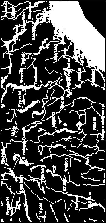
6 Study area East-Agder Telemark Vest-Agder


7
8 The idea or tool! Database North 1 1 East 1 2 NUmber of old houses X 1,hus X 2,hus Area with pasture X 1,dabeite X 2,dabeite 1 3 X 3,hus X 3,dabeite 2 1 X 4,hus X 4,dabeite. Calculated index for cell j: y j = f (x j, old house x j, area pasture ) North East Value 1 1 y y 2 y 3 Calculated value 2 1 y 4
9 Reference group What is interesting to include in the database? What should/could be used to rank areas?
10 Calculation of index to rank areas - some alternatives Count the number of times the cell has a value within a given range (0/1) Predict the probability that a cell belongs to a particular quality grouping. This method requires that we have enough quality controlled cells to estimate a model.
11 Requirements to a tool > Pick out cells that meet some requirements, as for example the index calculation > Visualize the data in the database by using maps > Calculate the total amount of potential selected areas, number of buildings, animals etc. witch are within the selected areas.
12 Data in the database and some examples
13 Database Land capability classification-(1:5000) (MARKSLAG) Farm land, 3 types of surface: Arable land Area that may be harvested mechanically, but it is not arable land Pasture, area not suitable for mechanical harvesting or ploughing Forested areas and other types of areas Calculations based on land capability classification: Hix (identical neighbouring points) Shannon diversity index Length of edges between farm land and other surface types Farmed area with slope (topographical model and land cover)
14 Database - continued Farm buildings (GAB) Old farm buildings (SEFRAK) Application for farm subsidies (PT-2006) Farm location Number of animals per farm Crop type with sum area per farm Archaeological registrations (Askeladden) several types Nature database (protected areas) Stone fences and solitaire trees Roads
15 Grid size We have used 2 km * 2 km and 1 km * 1 km. For data such farm density and number of animals, should we use larger areas, for example 3*3 km for each 1* 1 km cell.
16 Farm land as percent of the total area, 2*2 km grid
17 Percent of area with farm land with slope > 20%

18 Area of pasture, as share of the total farm land
19 Data quality example stone fences


20 How is the quality?

21 An example
22 Selection: Valley and mountain districts Share of cells that satisfy the criteria (%YES) Criteria %YES 1 % pasture of famed land 20%-70% 26 2 Length of stone fences, m Number of old farm buildings > Types of land cover (max 14 groups) > % of famed land with slope > 20 % > 20% 35 6 Water and famed land in the grid Yes 92 7 Old farm building / all farm buildings > 0,3 48
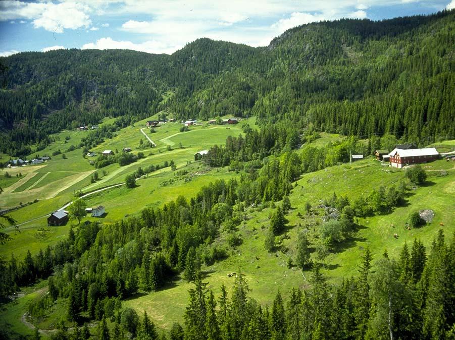
23 Valley and mountain districts

24
25
26 Morgedal Morgedal % pasture of farmed land 18,6 Area with pasture, m 2 % farmed land wit slope > 20 % Length of edges of farm land, m Length of stone fences, m Old farm houses (SEFRAK) # of land cover types (14 groups) Old farm buildings/farm buildings Both water and farmed land in the grid , ,3 1 Select 1 15%-30% 5-100% >15 >=8 > 0,25 1 Select 2 15%- 100% 5-100% >15 >=8 > 0,25 1

27 Morgedal selection 1

28 Morgedal selection 2

29 Arendal

30 Åsgrend in Tokke

31 Åsgrend in Tokke (photo Oskar Puschmann)
32 Other locations We have also looked at some other areas: A typical scenic landscapes along the coast An valued area in the forest region Hix and diversity index are not easy to explain nor understand, however they tend to vary between the different location we have studied.

33 The road ahead
34 Lessons learned Visualisation of the data directly from the database was valuable for the reference group. One should look within (farming) regions (somewhat homogeneous areas). Multiple grid sizes and aggregated data must be available for a given cell. We can find similar cells we can pin point where to take a closer look. We will probably be better at finding typical areas than special rare and interesting features. Data quality is an issue to look into.
35 Implications for future work We need to know what we are looking for! We need a better theoretical foundation for what we are looking at. What we value and want to maintain needs to be defined. Thus: How is the relationship between data we may measure and the quality of: Biodiversity Scenic beauty Accessibility Authentic cultural landscape

36 Morgedal (photo Oskar Puschmann)
Addressing the spatial resolution of agri-environmental indicators in Norway
 Addressing the spatial resolution of agri-environmental indicators in Norway WENDY FJELLSTAD, OSKAR PUSCHMANN AND GRETE STOKSTAD NORWEGIAN FOREST AND LANDSCAPE INSTITUTE ÅS, NORWAY Executive Summary In
Seminário New Deal - Innovation Apresentação de Wendy Fjellstad
 Seminário New Deal - Innovation Apresentação de Wendy Fjellstad Land use in Europe Agriculture in Norway: Status and Trends Wendy Fjellstad Norway: a land of forests and mountains Source: EEA, ETC Land
Are we moving in the right direction? Are we moving in the right direction? Are we moving in the right direction?
 2.1 Losses of cultural monuments and sites will be minimised. Percentage annual loss of cultural monuments and sites in selected areas Percentage annual loss of buildings on the SEFRAK register in selected
Estonian case study Evaluation of agri-environment schemes biodiversity objective
 Estonian case study Evaluation of agri-environment schemes biodiversity objective Eneli Viik Agricultural Research Centre eneli.viik@pmk.agri.ee Good Practice Workshop. Assessing environmental effects
Timberland Property Tax in Texas
 Presentation at the 2018 Texas Timber Workshop Timberland Property Tax in Texas February 13, 2018 Property Tax Assistance Division 1 Joe Holcomb Ag & Timberland Appraiser (512)936-6945 or 1-800-252-9121
Organic Production Requirements: Crop production and animal husbandry in general S S R A N A S R S C I E N T I S T
 Organic Production Requirements: Crop production and animal husbandry in general S S R A N A S R S C I E N T I S T 3.1 CROP PRODUCTION AND ANIMAL HUSBANDRY IN GENERAL 2 3.1.1 CONVERSION REQUIREMENTS 3.1.2
A new policy framework for a more sustainable EU agriculture. Pierre Bascou DG Agriculture and rural development European commission
 A new policy framework for a more sustainable EU agriculture Pierre Bascou DG Agriculture and rural development European commission 2 Objectives of the CAP Policy objectives Reform objectives Viable food
GREENING IN LATVIA. GAEC Workshop, Riga September 1
 GREENING IN LATVIA GAEC Workshop, Riga 10-12 September 1 Plan of the presentation: 1. Framework of the greening requirements 1.1. crop diversification 1.2. permanent grassland 1.3. ecological focus area
MEASURING THE IMPACT OF NORWEGIAN AGRICULTURE ON HABITATS Wendy Fjellstad Plenary Session 2 --
 MEASURING THE IMPACT OF NORWEGIAN AGRICULTURE ON HABITATS Wendy Fjellstad 1 -- Plenary Session 2 -- Ecosystem/Habitats Impacted by Agricultural Activities Tuesday 6 November 2001 Paper presented to the:
Introduction. Property Boundary and Survey Evidence
 Introduction The Peacham Town Forest is approximately 190 acres of land located in the Northwest corner of the town, close to the town line with Cabot. The tract is the former Ike Peck farm and was acquired
Managing archaeological sites in arable systems. Some farming issues
 Managing archaeological sites in arable systems Some farming issues The map above shows a typical arable field with soil marks of possible archaeological sites. The farm and soil marks are based on an
How is Water Quality Affected by Land Use?
 Watershed Connections Lesson Les4 3 How is Water Quality Affected by Land Use? Overview What are the benefits of a healthy watershed? What are examples of land uses? What types of pollution can come from
Chapter 4 Agricultural Resources of Juniata and Mifflin Counties
 Chapter 4 Agricultural Resources of Juniata and Mifflin Counties Agricultural Resources of Juniata and Mifflin Counties Introduction Juniata and Mifflin Counties have significant farmland nestled between
11. Prioritizing Farmlands for Future Protection
 11. Prioritizing Farmlands for Future Protection Identification of Important Farmlands in Putnam County I n order to implement this Plan successfully, Putnam County decision-makers will have to take advantage
Towards FRA 2010 some selected topics. Stein M. Tomter Norwegian Forest and Landscape Institute
 Towards FRA 2010 some selected topics Stein M. Tomter Norwegian Forest and Landscape Institute Forest Resources Assessments (FRA) > Conducted by FAO > Carried out since 1946 > 5-10 years intervals (currently
Crops Environment & Land Use Programme. Forest Roads
 FARM FORESTRY SERIES NO. 13 Crops Environment & Land Use Programme Forest Roads 2 Why build a forest road? Assists plantation inspection and management Provides access for timber transport. Good road design
Organic forest soils in Norway - an overview
 Organic forest soils in Norway - an overview Lise Dalsgaard O. Janne Kjønaas Holger Lange Norwegian Forest and Landscape Institute Organic forest soils in Norway - an overview - more questions than answers
Pastoral Plans to support mountain farming in SW Alps
 Pastoral Plans to support mountain farming in SW Alps Giampiero Lombardi,, Alessandra Gorlier, Michele Lonati, Massimiliano Probo Alpine pasture-lands in Piedmont semi-natural grasslands: 280.000 ha in
Building CSOs Capacity on EU Nature-related Policies EU Rural Development Policy
 Building CSOs Capacity on EU Nature-related Policies EU Rural Development Policy Mark Redman Valjevo, 27 October 2011 Total of 11 different seminatural plant communities can be identified in
Old Enon Plantation 1,330 +/- Acres Hardeman County, TN
 Old Enon Plantation 1,330 +/- Acres Hardeman County, TN Old Enon Plantation Located 1 Hour from Memphis Old Enon takes you back to a time when sharecropper shacks dotted cotton fields and cypress-clad
CURRENT ROLE OF GRASSLANDS IN SHAPING AND DEVELOPMENT OF RURAL AREAS IN POLAND AN EXAMPLE OF MOUNTAIN VOIVODSHIPS MAŁOPOLSKIE AND PODKARPACKIE
 CURRENT ROLE OF GRASSLANDS IN SHAPING AND DEVELOPMENT OF RURAL AREAS IN POLAND AN EXAMPLE OF MOUNTAIN VOIVODSHIPS MAŁOPOLSKIE AND PODKARPACKIE H. Jankowska-Huflejt 1, B. Wróbel 1, S. Twardy 2 1 Institute
SANTA CLARA Protections in place:
 SANTA CLARA s in place: General Plan Language Specific Tree Retention/ Replacement The Tree prohibits cutting 12 dbh trees on hillside zone parcels
St. Joseph County Farmland Preservation Program. Selection Criteria: Scoring System for Prioritizing Landowner Applications
 St. Joseph County Farmland Preservation Program Selection Criteria: Scoring System for Prioritizing Landowner Applications INTRODUCTION Part 362 of the Natural Resources and Environmental Protection Act
Driving forces of species diversity in unmanaged semi-natural grasslands and pastures
 Driving forces of species diversity in unmanaged semi-natural grasslands and pastures Jutta Kapfer, Einar Heegaard, Svein O. Krøgli, Christian Pedersen, Gregory Taff & Wenche Dramstad 57th Annual Symposium
TAC CHARRETTE WORKBOOK Ecosystem Management and Sustainable Forestry Practices
 For Discussion Purposes TAC CHARRETTE WORKBOOK Ecosystem Management and Sustainable Forestry Practices NEW JERSEY HIGHLANDS COUNCIL March 28, 2006 1 Overview of RMP Goals and Structure NEW JERSEY HIGHLANDS
Conservation Agriculture:
 Conservation Agriculture: Its deliverables for effective Soil Conservation and comments on the SoCo findings Gottlieb Basch Soil threats: Erosion Decline in organic matter Soil contamination Soil sealing
ARDTEATLE FOREST. Loch Awe, Argyll Hectares / Acres
 ARDTEATLE FOREST Loch Awe, Argyll 144.10 Hectares / 356.07Acres ARDTEATLE FOREST Dalmally 3 miles Fort William 61 miles Perth 73 miles (Distances are approximate) Glasgow 75 miles ARDTEATLE FOREST 144.10
Lesson 1. Commercial Thinning What is it? Definition. Objectives: Equipment Needs: Method: 60 minutes
 Lesson 1 Commercial Thinning What is it? Definition 60 minutes Objectives: 1. To get people thinking about commercial thinning. 2. To define commercial thinning according to B.C. Ministry of Forests policy.
Initial Stakeholder Meeting Report Intercropping of Walnut Trees in Greece
 Initial Stakeholder Meeting Report Intercropping of Walnut Trees in Greece Work-package 3: Agroforestry for high value trees Specific group: Intercropping of walnut trees with arable crops in Greece Date
Modelling Policies for Multifunctional Agriculture and Rural Development a Norwegian Approach
 Modelling Policies for Multifunctional Agriculture and Rural Development a Norwegian Approach FINAL CONFERENCE Brussels, 7 th May 2008 Karen Refsgaard, Sjur Prestegard and Arild Spissøy Norwegian Agricultural
Reporting of USDA Conservation Practices for Chesapeake Bay
 Reporting of USDA Conservation Practices for Chesapeake Bay Olivia H. Devereux, DEC, Inc. December 6, 2012 BMP Verification Review Panel with Dean Hively, USGS EGSC USGS Project Objectives To assist the
LAND, WATER AND ENVIRONMENT FARM AFRICA S APPROACH
 LAND, WATER AND ENVIRONMENT FARM AFRICA S APPROACH CONTENTS Farm Africa s vision Preface What s the issue? Theory of change Farm Africa s approach Methodology How to use Farm Africa s approach papers FARM
FARM BILL 2002 Colorado Conservation Provisions
 United States Department of Agriculture Natural Resources Conservation Service FARM BILL 2002 Colorado Conservation Provisions Conserving Natural Resources on Colorado s Privately Owned Farmland Farm Bill
Case Study of Payments for Environmental Services: the United Kingdom
 Case Study of Payments for Environmental Services: the United Kingdom Thomas Dobbs, South Dakota State University (USA) Jules Pretty, University of Essex (UK) Workshop on Payments for Environmental Services
Figure 1: Preservation Area
 Figure 1: Figure 2: Land Use Capability Map Zones Regional Master Plan Overlay Zone Designation Zone Protection Lakes Greater Than 10 acres Conservation Existing Community Sub-Zone Existing Community Environmentally
PERMIT APPLICATION FEES Fees must be paid at time of application
 Permits SEPA Checklist Permit # Staff use Governmental agencies use this checklist to help determine whether the environmental impacts of your proposal are significant. This information is also helpful
3 Outcome of the sustainability assessment
 the milk buyer. Where the data were fully entered into the computer on farm, the results were immediately shown to the farmer and there was opportunity for discussion. In all cases, farmers later received
Agri-environmental reporting - a national experience
 Agri-environmental reporting - a national experience By Ole Osvald Moss, Division for Primary Industry Statistics, Statistics Norway, NO-2225 Kongsvinger ole.osvald.moss@ssb.no October 2010 Abstract Statistics
Green Infrastructure: A Guide to Asset Mapping in the Rappahannock-Rapidan Region. Rappahannock-Rapidan Regional Commission December 2015
 Green Infrastructure: A Guide to Asset Mapping in the Rappahannock-Rapidan Region Rappahannock-Rapidan Regional Commission December 2015 What Is Green Infrastructure? Green infrastructure is an interconnected
DRAFT (July 2018) Butte County Oak Woodland Mitigation Ordinance
 Butte County Oak Woodland Mitigation Ordinance") DRAFT (July 2018) Butte County Oak Woodland Mitigation Ordinance Contents XX 1 XX 2 XX 3 XX 4 XX 5 XX 6 XX 7 XX 8 XX 9 Title Findings Purpose Relationship to Other Laws, Regulations and Ordinances Applicability
DRAFT (July 2018) Butte County Oak Woodland Mitigation Ordinance Contents XX 1 XX 2 XX 3 XX 4 XX 5 XX 6 XX 7 XX 8 XX 9 Title Findings Purpose Relationship to Other Laws, Regulations and Ordinances Applicability
Community LID Workgroup Issue Paper #3
 Topic: Clearing, Grading & Healthy Soils Community LID Workgroup Issue Paper #3 Objectives: Limit clearing, grading, and soil disturbance outside of the building footprint on newly developed residential
Rural Development Project
 Rural Development Project Sustainable Pasture, Arable and Forest Land Management (SPAFLM) Paul Strong Team Leader Funded by the Asian Development Bank and the Global Environment Facility RDP Five Components:
Maps for Nutrient Management Planning
 Maps for Nutrient Management Planning Table of Contents Introduction... 3 Dry Poultry NMP Exceptions... 3 Making a Base Map... 3 NRCS Toolkit... 3 Online Maps... 4 Photocopied Maps... 4 Additional or Supporting
Trenches combined with living hedges or grass lines Rwanda - Imiringoti
 Trenches combined with living hedges or grass lines Rwanda - Imiringoti Trenches combined with living hedges or grass lines are slow-forming terraces to control soil erosion by changing the length of the
PITTSBURGH REGIONAL DIVERSITY SURVEY RESULTS U.S.-BORN / FOREIGN-BORN DIFFERENCES
 PITTSBURGH REGIONAL DIVERSITY SURVEY RESULTS U.S.-BORN / FOREIGN-BORN DIFFERENCES Sample sizes: Born in US Frequency Percent Yes 3306 93.5 No 229 6.5 Employment status currently employed: Yes 86.8 87.0
Stone lines Uganda - Ennyiriri z'amayinja eziziyiza ettaka okutwalibwa enkuba (Luganda)
") Stone lines Uganda - Ennyiriri z'amayinja eziziyiza ettaka okutwalibwa enkuba (Luganda) Stone lines are built along a contour to control soil erosion on a degraded steep slope. left: Stone lines established
Stone lines Uganda - Ennyiriri z'amayinja eziziyiza ettaka okutwalibwa enkuba (Luganda) Stone lines are built along a contour to control soil erosion on a degraded steep slope. left: Stone lines established
ABANDONMENT AND LOSSES OF AGRICULTURAL LAND IN CZECHIA SINCE 1990 FROM A REGIONAL PERSPECTIVE
 ABANDONMENT AND LOSSES OF AGRICULTURAL LAND IN CZECHIA SINCE 1990 FROM A REGIONAL PERSPECTIVE JAN KABRDA, Faculty of Science, Charles University in Prague In cooperation with Přemysl Štychand Přemysl Vojáček,
Managing archaeological sites in arable systems. Some farming issues 2
 Managing archaeological sites in arable systems Some farming issues 2 Protecting cropmark sites on arable farms This farm is a run together with a neighbouring unit predominantly as an arable farm to make
EFFECTS OF ANTHROPOGENIC STRESSORS ON WATER QUALITY IN NORWEGIAN FORESTS
 EFFECTS OF ANTHROPOGENIC STRESSORS ON WATER QUALITY IN NORWEGIAN FORESTS Nicholas Clarke Norwegian Institute of Bioeconomy Research Photo: Kjersti Holt Hanssen Photo: Nicholas Clarke 12.9.17 1 Background
Opportunities within the Rural Development Policy
 Opportunities within the Rural Development Policy 3 rd workshop EU Sheep Meat Forum Michael Pielke Head of Unit DG Agriculture and Rural Development 2 Rural development policy principles EU legal framework
Why a forest level strategy?
 Lesson 5: An Overview 45 minutes Lesson Objectives To identify the level of detail out there in higher level plans. To provide guidance on how to use the higher level direction available. Method: Introduce
Riparian Forest Buffer Panel (Bay Area Incentive Programs)
") Program Buffer Incentive Program Virginia Agricultural BMP Cost- Share Program Virginia Agricultural BMP Cost- Share Program Practice Woodland Buffer Filter Area Loafing Lot Management System Incentive,
Program Buffer Incentive Program Virginia Agricultural BMP Cost- Share Program Virginia Agricultural BMP Cost- Share Program Practice Woodland Buffer Filter Area Loafing Lot Management System Incentive,
THE PROFITABILITY OF SEASONAL MOUNTAIN DAIRY FARMING IN NORWAY
 THE PROFITABILITY OF SEASONAL MOUNTAIN DAIRY FARMING IN NORWAY Leif Jarle Asheim 1, Tor Lunnan 2, and Hanne Sickel 2 1. Norwegian Agricultural Economics Research Institute, P. O. Box 8024, Dep., 0030 Oslo,
TYPICAL CONTENTS OF A SITE-SPECIFIC NATURAL RESOURCE AND WOODLAND STAND DELINEATION MAP:
 TYPICAL CONTENTS OF A SITE-SPECIFIC NATURAL RESOURCE AND WOODLAND STAND DELINEATION MAP: A Site Context Map (1"=200') for vicinity within 1000' of the property Scale of map (to match scale of submitted
Analysis of the potential for sustainable, cassava-based bio-ethanol production in Mali. Kjeld Rasmussen
 Analysis of the potential for sustainable, cassava-based bio-ethanol production in Mali Kjeld Rasmussen Institut for Geografi og Geologi Questions Are there land resources available to avoid the negative
PERSONAL WIRELESS COMMUNICATION FACILITY DESIGN STANDARDS. -Section Contents-
 SECTION 27A PERSONAL WIRELESS COMMUNICATION FACILITY DESIGN STANDARDS -Section Contents- 2701A Intent... 27-2 2702A General Policies... 27-2 2703A Approval Standards... 27-3 2704A Abandonment... 27-3 2705A
SURVEY OF PUBLIC ATTITUDES ABOUT WATER ISSUES IN COLORADO
 SURVEY OF PUBLIC ATTITUDES ABOUT WATER ISSUES IN COLORADO Matt Neibauer, Reagan Waskom, and Troy Bauder Colorado State University Dept. of Soil and Crop Sciences 1 Northern Plains and Mountains Regional
The A,B,C s of Marketing Your Timber. Greg Heidebrink Iowa Department of Natural Resources District Forester
 The A,B,C s of Marketing Your Timber Greg Heidebrink Iowa Department of Natural Resources District Forester A Develop a Plan! Your plan is your road map to achieving your goals for the property! Plan Development.
A software tool to support farmers decisions on Ecological Focus Areas
 A software tool to support farmers decisions on Ecological Focus Areas Ref: JRC/IPR/2014/H.4/0022/NC Dr John Tzilivakis & Dr Doug Warner Agriculture and Environment Research Unit (AERU) University of Hertfordshire,
NRI/FSD and FOREST CONSERVATION EXEMPTION SUBMISSION REQUIREMENTS
 Detailed description of the submission requirements for the NRI/FSD and forest conservation exemption requests may be found in the MNCPPC Trees Technical Manual. The applicant, applicant s agent, or qualified
Appendix I. Estimating California s Agricultural Acreage
 Appendix I. Estimating California s Agricultural Acreage How much agricultural land is there in California? Of course, the answer depends on how agricultural land is defined. But even when one is working
Background Paper. Sustainable Bioenergy cropping systems for the Mediterranean. Expert Consultation
 Background Paper Sustainable Bioenergy cropping systems for the Mediterranean Expert Consultation Introduction Bioenergy is a key issue in the context of policies to mitigate global warming, to reduce
ENVIRONMENTAL FEATURES OF THE TOWN
 Town of Aurora Map 1 11 12 ENVRONMENTAL FEATURES TOPOGRAPY Maps 1 and 2 show the locations of important natural features of the Town of Aurora. Aurora is located in the Alleghany Plateau, a region of broad,
BIOENERGY PRODUCTION AND ECOSYSTEM SERVICES CONSERVATION IN THE ALPS
 BIOENERGY PRODUCTION AND ECOSYSTEM SERVICES CONSERVATION IN THE ALPS Florian Kraxner (IIASA), Sylvain Leduc (IIASA), Sabine Fuss (MCC), Georg Kindermann (IIASA), and many more... International Energy Workshop
Solving wicked problems on the Wye. Lessons for elsewhere?
 Solving wicked problems on the Wye Lessons for elsewhere? Wye and Usk Foundation and partners 1996- Successfully dealt with issues within our control. - Salmon exploitation (Nets 2002, Rods 2012) - Riparian
American Tree Farm System Management Plan Template
 American Tree Farm System Management Plan Template State Tree Farm # Tree Farm Property Location Tree Farm Name: Ownership 1 : County: Tax Map ID: Location 2 : State: GPS Coordinates: Tree Farmer Contact
Sudan Sustainable Natural Resources Management Project (SSNRMP)
") Accra, Ghana May, 2017 General Overview: Sudan Sustainable Natural Recourses Management Project Development Objective To increase the adoption of sustainable land and water management (SLWM) practices
Accra, Ghana May, 2017 General Overview: Sudan Sustainable Natural Recourses Management Project Development Objective To increase the adoption of sustainable land and water management (SLWM) practices
Soil Erosion map of Europe based on high resolution input datasets
 Soil Erosion map of Europe based on high resolution input datasets Panagos Panos 1, Pasqualle Borrelli 1, Katrin Meusburger 2, Cristiano Ballabio 1, Christine Alewell 2 1 European Commision Joint Research
Soil Mapping, Classification and Land Use Planning. Environmental Management Branch Ontario Ministry of Agriculture, Food and Rural Affairs
 Soil Mapping, Classification and Land Use Planning Environmental Management Branch Ontario Ministry of Agriculture, Food and Rural Affairs Farmland Forum - March 2017 1 Pressures on Ontario s Soils Loss
Responses to dynamics in the ecosystem service provision in semi-arid Bobirwa sub-district, Limpopo Basin part of Botswana
 Responses to dynamics in the ecosystem service provision in semi-arid Bobirwa sub-district, Limpopo Basin part of Botswana Ephias Mugari, Hillary Masundire & Maitseo Bolaane 5 th INTERNATIONAL CLIMATE
Norwegian financial contributions to the objectives of the Convention on Biological Diversity Content
 Norwegian financial contributions to the objectives of the Convention on Biological Diversity Content 1. Background...2 2. General notes on methodology and scope...2 3. Environmental budgets...4 4. National
VALUATION OF PUBLIC GOODS AND ECOSYSTEM SERVICES PROVIDED BY AGRICULTURE
 VALUATION OF PUBLIC GOODS AND ECOSYSTEM SERVICES PROVIDED BY AGRICULTURE Ligita Melece Ligita.melece@arei.lv Ilze Šēna Institute of Agricultural Resources and Economics 17 th International Scientific Conference
HNV Farmland in Bulgaria. Vyara Stefanova Conference High Nature Value Farmland in Europe June 2010, Vilm
 HNV Farmland in Bulgaria Vyara Stefanova Conference High Nature Value Farmland in Europe 14 18 June 2010, Vilm Facts and figures Total area of Bulgaria = 11.1 million ha UAA = 5.3 million ha - Arable land
Welcome. Welcome and thank you for taking the time to come to this information session for our proposed Denzell Downs wind farm.
 Welcome Welcome and thank you for taking the time to come to this information session for our proposed Denzell Downs wind farm. Update: In 2011 Cornwall Council s Planning Committee granted permission
Forestry Grant Scheme Financial Support: Woodland Creation. Ian Cowe Forestry Commission Scotland - Grampian Conservancy 26 th October 2017
 Forestry Grant Scheme Financial Support: Woodland Creation Ian Cowe Forestry Commission Scotland - Grampian Conservancy 26 th October 2017 Forestry Commission Scotland Grampian Conservancy The conservancies
When the land division tree preservation requirements apply
 INFORMATION GUIDE Tree Preservation on Your Land Division Site The land division process provides the flexibility and opportunity to promote creative site design that considers multiple objectives, including
Valuing New Jersey s Natural Capital:
 Valuing New Jersey s Natural Capital: An Assessment of the Economic Value of the State s Natural Resources April 2007 State of New Jersey New Jersey Department of Environmental Protection Jon S. Corzine,
All farmers subject to greening. Crop Diversification Permanent grassland Ecological focus area (EFA)
") All farmers subject to greening Crop Diversification Permanent grassland Ecological focus area (EFA) Payment calculated as percentage of BPS payment approx. 45% of top-up to BPS payment. Greening payable
All farmers subject to greening Crop Diversification Permanent grassland Ecological focus area (EFA) Payment calculated as percentage of BPS payment approx. 45% of top-up to BPS payment. Greening payable
Farming in the North York Moors
 Resources for topics Farming in the North York Moors Curriculum Links Geography: Geographical regions and their identifying human and physical characteristics, key topographical features and land-use patterns.
Rezoning the Exclusive Farm Use (EFU) portion of the property to to Forest Mixed Use (FMU).
 portion of the property to to Forest Mixed Use (FMU).") Coos County Planning Department CoosCounty Courthouse Annex, Coquille, Oregon 97423 Mailing Address: 250 N. Baxter, CoosCounty Courthouse, Coquille, Oregon97423 Physical Address: 225 N. Adams, Coquille,
Coos County Planning Department CoosCounty Courthouse Annex, Coquille, Oregon 97423 Mailing Address: 250 N. Baxter, CoosCounty Courthouse, Coquille, Oregon97423 Physical Address: 225 N. Adams, Coquille,
Class Principal Soils
 LAND RESOURCES Soil Characteristics Soils in the hilly regions are formed from material weathered from granitic gneiss and other igneous or metamorphosed rocks. They belong to the Chester-Glenville-Brandywine
Chapter 1 Resources and Development
 Chapter 1 Resources and Development Resources Substances available in our environment that can be used for specific purposes and are technologically accessible, economically viable and culturally acceptable
FOSTERING COMMUNITY FOREST MANAGEMENT IN NAGALAND, INDIA
 FOSTERING COMMUNITY FOREST MANAGEMENT IN NAGALAND, INDIA sureshc@teri.res.in The Energy and Resources Institute, New Delhi 5 th February, 2014 Introduction This project is collaboration between State Government
Advisory methodology and system possibilities to educate forest owners, professionals & consultants GUIDE BOOK
 Advisory methodology and system possibilities to educate forest owners, professionals & consultants GUIDE BOOK PREFACE This document was created as a result of a Grundtvig Lifelong Learning adult education
Functional land management and carbon sequestration: balancing the competition for land
 Functional land management and carbon sequestration: balancing the competition for land Rogier P. O. Schulte 1,3, Lilian O Sullivan 2, Kristine Valujeva 3, Rachel E. Creamer 1 and Arwyn Jones 4 1. Wageningen
This page intentionally left blank
 Monterey County has elected to include an as part of the General Plan. Agriculture consisting of crop farming and livestock grazing is the largest industry in the County and contributes a significant amount
Site Condition Evaluation & Environmental Benefits Report
 Site Evaluation & Environmental Benefits Report Background The New York State Conservation Reserve Enhancement Program is a collaborative effort between the USDA and the State of New York. The goal of
WQMP AMENDMENT REVIEW CHECKLIST
 State of New Jersey Highlands Water Protection and Planning Council 100 North Road (Route 513) Chester, New Jersey 07930-2322 (908) 879-6737 (908) 879-4205 (fax) www.highlands.state.nj.us WQMP AMENDMENT
PITTSBURGH REGIONAL DIVERSITY SURVEY RESULTS JOB SECTORS
 PITTSBURGH REGIONAL DIVERSITY SURVEY RESULTS JOB SECTORS Sample sizes: Job Sector Frequency Percent 286 11.2 902 35.4 Health Care & 340 13.4 Information 111 4.4 328 12.9 Professional, 298 11.7 159 6.2
Pinheiro Ranch 55+/- Acres Orchard Development Ground Orland, CA. Presented By:
 Pinheiro Ranch 55+/- Acres Orchard Development Ground Orland, CA Presented By: Pinheiro Ranch 55+/- Acres Orchard Development Ground Orland, CA Location: This property is located on the SE corner of Road
APPENDIX Y SEPA CHECKLIST AND DNS
 APPENDIX Y SEPA CHECKLIST AND DNS Planning & Development Services Division Current Planning Section 840 Northgate Drive Richland, WA 99352 509/942-7598 FAX 509/942-7764 State Environmental Policy Act
Recommended Findings
 A Recommended Findings Aloft Winery P16-00429-UP Planning Commission Hearing Date September 5, 2018 PLANNING COMMISSION HEARING SEPTMBER 5, 2018 RECOMMENDED FINDINGS ALOFT WINERY USE PERMIT P16-0429-UP
22. If you have given up keeping grazing animals, when did this happen: Why did this happen:
 Feedback questionnaire on Bull by the Horns project In lack of other instructions, choose the correct alternative or write your answer. Part A: Project s operation Role in the Bull by the Horns project
Declaring EFA: learning from a virtual case
 Declaring EFA: learning from a virtual case Vincenzo Angileri European Commission, Joint Research Centre, Institute for Environment and Sustainability, Via E. Fermi 2749, I-21027 Ispra (VA), Italy 2014
Functional Land Management: A governance tool to develop the bio-economy? Rogier Schulte & Dina Popluga
 Functional Land Management: A governance tool to develop the bio-economy? Rogier Schulte & Dina Popluga Ireland - Latvia Latvia Area 64 589 km 2 Population 1 989 768 Population density 30.8/km 2 Highest
Biodiversity Conservation
 SITE PLAN REVIEW & BIODIVERSITY CONSERVATION Hudsonia Ltd. Session 3 of a workshop series sponsored by the Teatown Lake Reservation Site Plan Review & Biodiversity Conservation Biodiversity and Ecosystem
Timberland Property Tax in Texas. Texas A&M Forest Service
 Timberland Property Tax in Texas Texas A&M Forest Service 1 Outline Timberland property tax State tax incentives for timberland Landowners rights and remedies Wildlife management valuation on timberland
Jo Ellis The Forestry Commission National Office for England Great Eastern House Tenison Road Cambridge CB1 2DU. 28 January 2002.
 Jo Ellis The Forestry Commission National Office for England Great Eastern House Tenison Road Cambridge CB1 2DU 28 January 2002 Dear Jo Ellis, I am writing on behalf of the Executive Committee (England
The Mountain EbA Project in Peru. Lessons learned from implementing the approach
 The Mountain EbA Project in Peru Lessons learned from implementing the approach implemented by in association with Executed by mandate of Financed by The MOUNTIAN ECOSYSTEM-BASED ADAPTACION (Mountian EbA)
Figure 1: Preservation Area
 Figure 1: Figure 2: Land Use Capability Map Zones Regional Master Plan Overlay Zone Designation Zone Protection Lakes Greater Than 10 acres Conservation Existing Community Sub-Zone Existing Community Environmentally