ICMA Solutions Track Session. Information Rules. Communicating with Residents in the Google Era
|
|
|
- Ferdinand Parsons
- 5 years ago
- Views:
Transcription


1 ICMA Solutions Track Session Information Rules Communicating with Residents in the Google Era October 8, 2012


2 Today s Speakers Benjamin Webb Program Manager DMP Ben works with government customers to implement and extend DMP s Cloud GIS solutions. He has also managed numerous land use planning projects for municipalities and regional economic development organizations. Annie Schwab Vice President Marketing DMP Annie is an expert in the application of user-friendly spatial technology to everyday business, government and consumer problems. She currently works with industry visionaries to understand mapping trends and new technologies. 2
3 Presentation Overview Google Era & Citizen Information Expectations Successful Online Maps for Residents Tips for Creating Useful Maps Helpful Data to Share Benefits for Local Government Questions 3

4 Cloud-Based Mapping Technology Company Located in Orange County, California Over a decade of experience developing mapping technology for the web Mission: embed spatial technology and make it easy to use Mapping Solutions Software-as-a-Service mapping applications Local Government, Real Estate Spatial Development Platform, APIs Web services used by real estate sites, technology firms & government agencies Parcel Data Solutions: Boundaries, Geocodes About Digital Map Products 4

 to engage")
5 Poll 1: Are you Web 2.0? Question: Does your city use Web 2.0 technologies (maps, social media, YouTube, e-gov) to engage citizens? 5

6 Google Era Citizen Expectations In the Google Era: Lives Defined by Information Access to vast amounts of information Plugged in, online, and technology driven Impatient: expect ready info access wherever, whenever Accustomed to working with data on maps Information Expectations Data, data, data 24x7 online access, including mobile Current, interactive & location-enabled Government Expectations Transparency Two-way conversations Available through familiar channels Easy to use technology 6


7 Communicating with Web 2.0 Tech What is it? Two way communication through the web What does it do for you? Allowing for 24/7 communication between the City and its Citizens: Fast, Assessable, Effective A Few Examples Allow the citizens to report Pot holes, Street Outages, General Issues Communicate Road Closures, Projects and Events Services that can help Tips Facebook, Twitter, Google+, Your Website Be dedicated to responding Update Continuously 7

8 External Challenges Organizational Challenges Challenges in Citizen Communication New and Exceedingly High Citizen Expectations Access, Technology Medium, Usability Rapid Pace of Technology Change Economic Realities: budget cuts, staff shortages Solutions don t utilize existing assets Department mindset for data organization Massive volume of data, much spatial in nature Online access adds complexity Lack of expertise in web 2.0, mapping, mobile, usability 8


9 Why Maps? Location is universally understood Maps are one of the easiest ways for our brains to process information Most data can be displayed on maps Consumers increasingly map-savvy and expect location context Ideal medium for: Displaying large amounts of info Relating Data Exploring & Interacting with Data Analyzing Data Maps Optimal for Government/Public Data Sharing 9
10 Successful Online Citizen Maps 10
11 CommunityView Product Overview Online Interactive Maps for Local Government Websites Platform for publishing your data on public facing maps Share Property information Agency data, services, & updates Community amenities & events Easy to use: built on popular & familiar mapping platforms Lets residents self-service information requests 24x7 Reduces in-person & phone inquiries & enhances citizens knowledge of their community 11


12 City of San Juan Capistrano Embracing the Past & Leveraging Technology for the Future Small Southern California city with 35,000 residents and 100 city staff Rich history dating back 230+ years Dedicated to building strong community, maintaining heritage, & preserving open space Committed to using technology Using Cloud GIS since 2002 Recipient of several technology innovation awards 12

13 Community Information & Maps 13
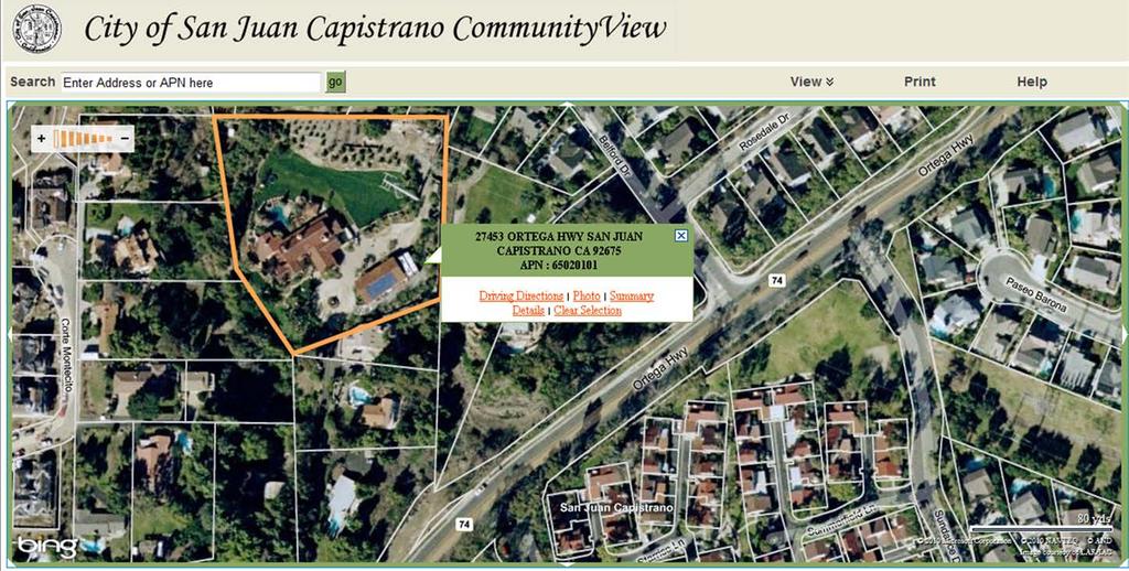


14 Property Information: Boundaries & Details 14


15 Community Amenities Hiking & Horse Trails & Other Community Amenities 15
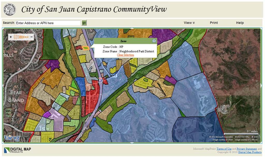

16 Property Information: Zoning & Land Use 16


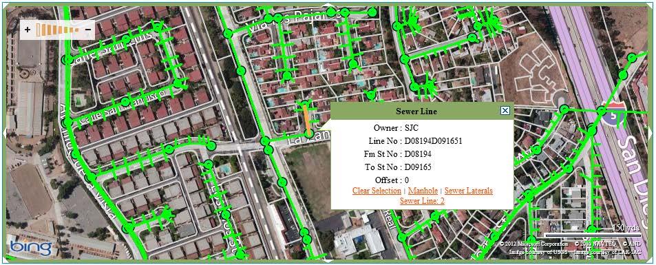
17 Agency Assets: Utilities Water, Sewer 17

18 Agency Services: Street Sweeping Schedules 18


19 City of Longview Leveraging Technology for the Future Small Southern Washington city with 35,000 residents and 335 city staff Budget cuts decimated the GIS staff down to 1 full time employee Long-Standing citizen requests for web-mapping fulfilled Traditional approach not feasible Virtually all city staff and many citizens using Cloud GIS 19
20 City of Longview, WA Easy to Find Map! 20

21 Property & Planning Information Property and Planning Information 21

22 Property & Planning Information Property and Planning Information 22

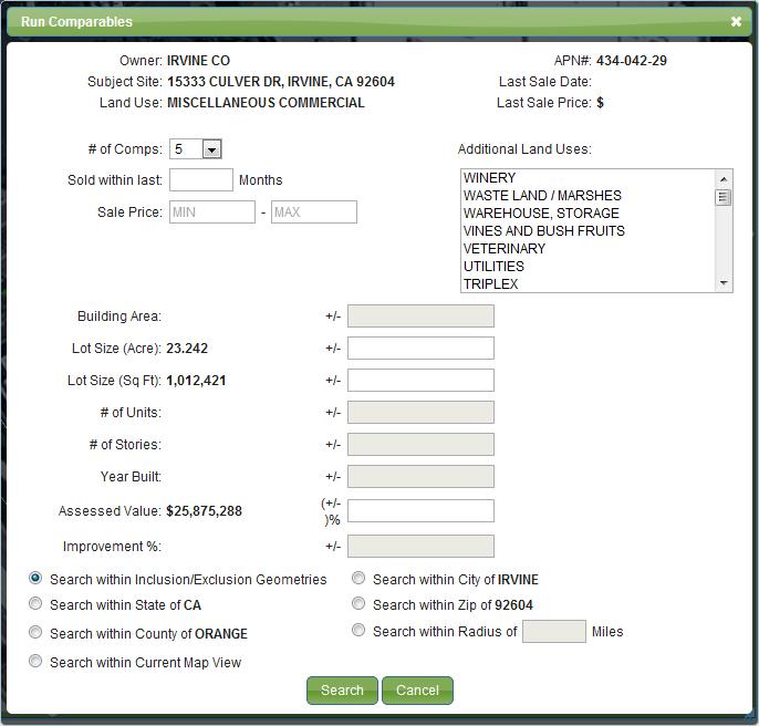
23 Property & Planning Information Future Land Use 23

24 Community Amenities Biking and Walking Trails 24


25 Community Events & Activities Concerts, Farmer s Markets, Celebrations 25


26 Community Services: Parks & Recreation Linked to: Facilities, Hours, Rental Forms, Directions, Events 26


27 Community Services: Public Transportation Bus Stops, Routes Linked to Additional Transit Information 27


28 Public Data: Pulling it all Together Wedding Sites 28


29 Property Information & Related Links Property Information APN Year Built Lot size Legal desc Tax Rate Exemption s Linked Information View Tax Bill File an appeal Get an Exemption Change mailing address 29


30 Property Information: Aerial Imagery High resolution aerial imagery Historical aerials Bird s eye / obliques 30


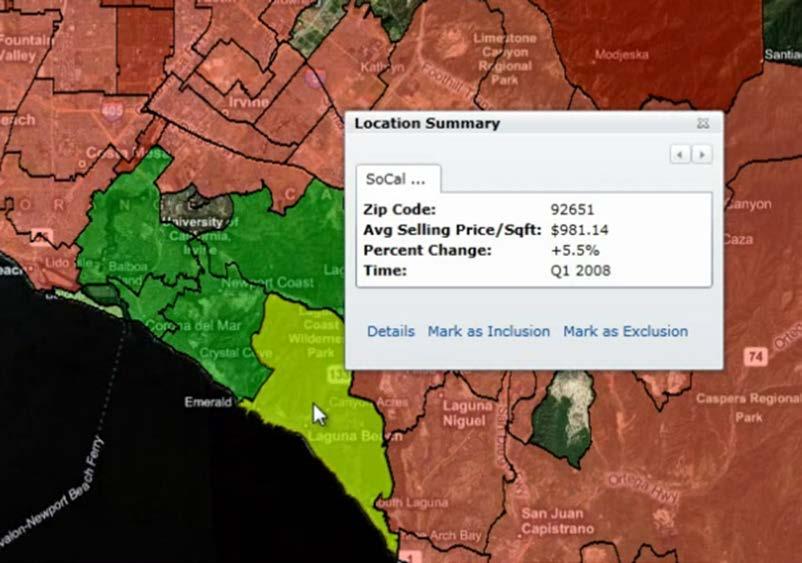
31 Property Information: Recent Sales ½ mile 31


32 Animated Layers: Trends Over Time 32


33 Citizen Engagement Publicizing Community Events Council Meetings location & link to agenda Event Logistics: route, road closures, and parking Holiday celebrations Farmer s Markets Issue Reporting Streetlight Outage Graffiti Abandoned Vehicles / Blight Public Participation Provide feedback on proposed projects Submit events and announcements 33


34 Citizen Engagement Constituent Issue Reporting from CommunityView 34


35 Facilitating Information Transactions Online Tax Maps Comparables Notification Lists Parcels Property Record Data 35


36 Tips for Creating Public Maps 36
37 Example Data to Share on Maps Property Information Details: boundaries, lot size, APN, assessed value, owner Restrictions: setback, easement, ROW Aerial Photos & Historical Images Zoning Permits Tax Maps Redevelopment Areas TODs Tax Rates Municipal Assets & Activities Road work / street closures Capital Improvement Projects Emergency Response / Disaster Info Utilities, streetlights, parking Voting Precincts / Locations Meeting locations Proposed Plans & Updates Municipal Services Street Sweeping / Trash Pickup Days Parks & Recreation Utility Service Areas Government Offices & Post Offices Public Health & Safety (fire, police, hospitals) Publicly owned properties Community Amenities Libraries & Schools School Districts / Attendance Zones Neighborhoods / HOAs Public Transit Stops & Routes FEMA Flood & Fire Hazard Local Events Trails, Bike Lanes Demographics Businesses 37

38 Creating Maps the Public Will Love Tip #1: For Maps that Please, Think of the End User Simple, fast, and familiar Intuitive color schemes & terms, good data display User Interface, UI, Usability: invest in it! Tip #2: Be Obsessed with Performance & Accuracy Layers & searches need to load FAST Optimize for the web environment Keep data current Tip #3: Make Your Maps Easy to Access Prominent Links: home page, departments Group data into themes Cross browser & mobile compatible 38
39 Benefits for your Organization Meets residents 24x7 online information access needs Increases community participation & engagement Heightens resident awareness of community amenities Enables residents to self-service many information requests, saving municipal staff time & money Highlight community features to attract businesses and visitors Supports green initiatives through: Reduced trips to gov t offices, printing Fosters government transparency Online Maps: Progressive Government & Leadership 39
40 Your Citizen Engagement Cheat-Sheet The Information Age Brings New Expectations Residents want 24x7 online access to info through easy to use tools that offer 2-way communication Maps are ideal to share data with the public Longview: leverage the cloud & commercial technologies to make the most of limited resources San Juan Capistrano: combine web 2.0 technologies to highlight amenities Highland: linking info increases usability For maps that please, think of the user Online Maps Improve Efficiency & Constituent Service 40

41 More information and Resources Digital Map Products & CommunityView Information Mapping Best Practices Whitepapers, Articles, Videos, Recorded Webinars Connect With Us Blog: LinkedIn: MAPS (6277) 41


42 42
Digital Map Products. Talk to Me: Using Mapping to Communicate with Citizens in the Google Era
 Digital Map Products Talk to Me: Using Mapping to Communicate with Citizens in the Google Era May 9, 2012 Today s Speakers Skip Cody, Technical Product Manager, DMP Skip has worked in the GIS/Mapping industry
The Cloud Revolution:
 GITA GIS for Oil & Gas Pipeline Conference The Cloud Revolution: Leveraging Cloud Computing for GIS Success October 26, 2011 Today s Speakers Jim Skurzynski, President & CEO, Digital Map Products Jim has
Capital Planning and ROW Permitting Maps and Apps for Local Government. Chris Fox Scott Oppmann
 Capital Planning and ROW Permitting Maps and Apps for Local Government Chris Fox Scott Oppmann Agenda Introduction Solution Offering What s Next Your Feedback ArcGIS Solutions for Local Government Improving
Request for Proposal: Website Development, Design, & Implementation. Issued March 26, 2018
 Request for Proposal: Website Development, Design, & Implementation Issued March 26, 2018 The City of Winooski Department of Community and Economic Development 27 West Allen Street Winooski, VT 05404 802
A Guide for Local Governments: EAM and GIS for Complete Asset Management
 29 91 $1,487 A Guide for Local Governments: EAM and GIS for Complete Asset Management A Guide for Local Governments: EAM and GIS for Complete Asset Management Think back to a time before smartphones. You
Achieve Transparency with Online Access to Property Data
 iasworld public access a tyler appraisal & tax solution Achieve Transparency with Online Access to Property Data iasworld Public Access the Easy and Cost-effective Way to Better Serve and Connect with
ArcGIS Solutions for State and Local Government. Daniel Wickens Scott Oppmann
 ArcGIS Solutions for State and Local Government Daniel Wickens Scott Oppmann Agenda Introduction Solution Offering What s Next Your Feedback Common Goals Every municipality has similar aspirations Well
GIS Consortium BUILDING SMARTER COMMUNITIES
 GIS Consortium BUILDING SMARTER COMMUNITIES residents GIS Consortium Overview Geographic Information Systems (GIS) is an integral tool for cities. It enables efficient and effective planning and implementation
Mosquito Control Maps and Apps for Local Governments. Chris Fox
 Mosquito Control Maps and Apps for Local Governments Chris Fox ArcGIS Solutions for State and Local Government Improving local government operations and enhancing services provided to the public Collection
Branding, Development, and Marketing Action Plan
 Branding, Development, and Marketing Action Plan Town of Concrete 2017 Prepared by Concrete Economic Development Commission The resulting branding and marketing plan, as outlined in this report, is built
ArcGIS for Local Government: An Overview SCOTT OPPMANN
 ArcGIS for Local Government: An Overview SCOTT OPPMANN Agenda Introduction Why? Solution Offering What s Next Your Feedback Using ArcGIS to understand and mitigate challenges Housing Forecasting Urban
VILLAGE OF FOX LAKE STRATEGIC PLAN - AN OVERVIEW
 - AN OVERVIEW 2017-2022 1 THE The Village of Fox Lake (population 10,700) is located 55 miles northwest of downtown Chicago and 20 miles west of Waukegan, Illinois. Fox Lake is a non-home rule community
GOOD NEIGHBOR POLICY
 Regional Open Space MIDPENINSULA REGIONAL OPEN SPACE DISTRICT GOOD NEIGHBOR POLICY Adopted by the Board of Directors October 26, 1988 Amended August 14, 1996 Amended September 26, 2007 Introduction The
Megan Heckert, Avencia Incorporated Robert Cheetham, Avencia Incorporated C H A P T E R N I N E
 Bringing Multi-criterion Siting Decisions to the Web Megan Heckert, Avencia Incorporated Robert Cheetham, Avencia Incorporated C H A P T E R N I N E PhillydotMap 64 In 2000, a young Philadelphia couple
COUNTY OF SAN JOAQUIN STRATEGIC DIRECTION FOR INFORMATION TECHNOLOGY
 COUNTY OF SAN JOAQUIN STRATEGIC DIRECTION FOR INFORMATION TECHNOLOGY San Joaquin County government will transform the manner in which it provides services to the public and its employees so as to promote
Marketing Services for Q2 Customers CAPABILITIES BROCHURE
 Marketing Services for Q2 Customers CAPABILITIES BROCHURE End User Marketing, Creative Services, and Advisory Services We focus on being a strategic partner for future growth and providing the tools and
Marketing Services for Q2 Customers CAPABILITIES BROCHURE
 Marketing Services for Q2 Customers CAPABILITIES BROCHURE End User Marketing, Creative Services, and Advisory Services We focus on being a strategic partner for future growth and providing the tools and
Implementing ArcGIS Solutions. Matt Viverito Scott Oppmann
 Implementing ArcGIS Solutions Matt Viverito Scott Oppmann GIS Has Evolved Your GIS is an Interconnected Platform Apps Web GIS Desktop ArcGIS Server Bringing Together Data, Technology, and People......
Digital Markham Strategy. PRESENTATION TO GENERAL COMMITTEE Jan. 16, 2017
 Digital Markham Strategy PRESENTATION TO GENERAL COMMITTEE Jan. 16, 2017 Digital Markham Strategy Agenda Background Current State Assessment The Vision The Roadmap Opportunities Recommendations 2 Background:
Strategic Plan
 Corporation of the Township of Esquimalt 2008 Strategic Plan Focussing on community priorities, the Township of Esquimalt provides quality municipal services through open and innovative leadership MESSAGE
Enterprise Land Management System (elms ) Integrating Business Processes within Local Government. An Edgesoft Whitepaper
 Integrating Business Processes within Local Government. An Edgesoft Whitepaper") An Edgesoft Integrating Business Processes within Local Government Copyright 2008 Edgesoft, Inc. All Rights Reserved. An Overview At a time when public sector organizations nationwide are facing budget
An Edgesoft Integrating Business Processes within Local Government Copyright 2008 Edgesoft, Inc. All Rights Reserved. An Overview At a time when public sector organizations nationwide are facing budget
Strategic Planning and Performance Measurement
 Strategic Planning and Performance Measurement Performance measurement has been an important component of Shawnee s budget process for a number of years. The City s performance measurement system was driven
VISION Create a progressive and safe community in which to live, work and visit.
 VISION Create a progressive and safe community in which to live, work and visit. MISSION Have a high performance organization that provides high quality services that enhance all citizens quality of life.
The Cloud Using Information to engage your community. Dennis Harward & Robert Tipton ICMA Conference Presenters
 The Cloud Using Information to engage your community Dennis Harward & Robert Tipton ICMA Conference Presenters Presenters Dennis Harward Founder: HTE 50+ Successful applications 1,000+ customers Co-Founder:
State and Local Governments
 Public Engagement Maps and Apps for State and Local Governments ALLISON MUISE SCOTT OPPMANN Agenda Introduction Public Engagement Maps and Apps What s Next Your Feedback ArcGIS as a Platform Simple, Open,
Digital Strategy 1.0. Office of the Chief Information Officer OCIO City of Vaughan
 1.0 Office of the Chief Information Officer OCIO City of Vaughan Rev. December 14, 2016 Communications COMMUNITY ENGAGEMENT eservices + Mobile Apps 24/7 Access to Data + Content TRANSPARENCY Internal Digital
SILVER LEVEL AWARD WINNER. City of Carson Sustainability Best Practices Activities
 SILVER LEVEL AWARD WINNER City of Carson Sustainability Best Practices Activities SPOTLIGHT AWARD Areas of Accomplishment SILVER LEVEL GOLD LEVEL PLATINUM LEVEL Agency GHG Reductions 26% Community GHG
Lake County Internet-based GIS tools
 Lake County Internet-based GIS tools This document highlights twenty-three Internet-based GIS tools that have been developed to provide information and tools that have greatly enhanced the productivity
2015 Connected Cities Report
 INDUSTRY RESEARCH: PUBLIC SECTOR 0 Connected Cities Report A Ranking of U.S. Cities and Their Use of Digital Technologies to Connect with Residents About This Report A connected city is one that joins
DRAFT 2016 Budget and Financial Plan
 DRAFT 2016 Budget and 2017-18 Financial Plan Presentation to Finance, Administration and Audit Committee 1 What Are the Numbers? 2 2016 Budget 2017-18 Plan $M 2016 2017 2018 Budget Forecast Gross Operating
Configuring the ArcGIS for Local Government Solution CHRIS FOX SCOTT OPPMANN
 Configuring the ArcGIS for Local Government Solution CHRIS FOX SCOTT OPPMANN Agenda Introduction Implementation Patterns Configuration Approaches Your Feedback ArcGIS as a Platform Simple, Open, and Configurable
How local governments can better leverage social media. (330)
") How local governments can better leverage social media A rich resource of information from the Fels Research & Consulting study Making the Most of Social Media https://www.fels.upenn.edu/sites/www.fels.upenn.edu/files/final_redesigned_social_media_0.pdf
How local governments can better leverage social media A rich resource of information from the Fels Research & Consulting study Making the Most of Social Media https://www.fels.upenn.edu/sites/www.fels.upenn.edu/files/final_redesigned_social_media_0.pdf
ArcGIS for State Government An Overview. Christian Carlson Nikki Golding
 ArcGIS for State Government An Overview Christian Carlson Nikki Golding Environment DOT Economic Development Public Health Emergency Management Vibrant Community Sustainable Community Safe Community Healthy
ArcGIS. for Land Records
 ArcGIS for Land Records Purpose Built and Configurable Gone are the days of building a custom real-time land records operation from scratch. Such systems are costly to maintain, lack capability, and don
FY2016/17 Approved Budget. SECTION 17 Information Technology
 17 SECTION 17 Information Technology 189 Information Technology The Department of Information Technology (IT) is committed to ensuring IT investments and strategic business technologies deliver the highest
PUBLIC PARTICIPATION PLAN STRATEGY. A general outline for how a community may organize its public participation plan
 PUBLIC PARTICIPATION PLAN STRATEGY A general outline for how a community may organize its public participation plan INTRODUCTION A public participation plan (P³) is essential for outlining how the public
ArcGIS for Local Government Public Works Solutions. Scott Oppmann
 ArcGIS for Local Government Public Works Solutions Scott Oppmann GIS Is Evolving Your GIS Is Becoming Part of an Interconnected Platform Apps Web GIS Desktop Community Content Server Bringing Together
8 Tips to Recruiting, Retaining & Reactivating Anglers. Empowering government to create better lives for more people.
 8 Tips to Recruiting, Retaining & Reactivating Anglers Empowering government to create better lives for more people. WELCOME NATALIE FEDIE GovDelivery Vice President of Client Success Customer Success
ArcGIS for Environment and Natural Resources An Overview. Matt Bullock Nikki Golding
 ArcGIS for Environment and Natural Resources An Overview Matt Bullock Nikki Golding Agenda Introduction Solution Offering What s Next? Your Feedback ArcGIS as a Platform Knowledge Workers Executive Access
Spring PERFECTING The Passenger Experience. Selena Barlow
 Spring 2011 PERFECTING The Passenger Experience Selena Barlow What is the Passenger Experience? Passenger Experience Everything the customer experiences when they use, or try to use, transit. Passenger
OC LAFCO RFPs on San Juan Capistrano Utility System Municipal Services Review Pre-proposal Conference Questions and Answers
 OC LAFCO RFPs on San Juan Capistrano Utility System Municipal Services Review Pre-proposal Conference Questions and Answers On August 24, 2017, the Orange County Local Agency Formation Commission (LAFCO)
Public Works Maps and Apps for Local Governments CHRIS FOX SCOTT OPPMANN
 Public Works Maps and Apps for Local Governments CHRIS FOX SCOTT OPPMANN Agenda Introduction Solution Offering What s Next Your Feedback ArcGIS as a Platform Simple, Open, and Configurable Knowledge Workers
Digital Media M A R I L Y N G O O D M A N
 Digital Media M A R I L Y N G O O D M A N The Evolution of Social Media The world of social media has evolved at a remarkable pace. Social has transformed consumer expectations and corporate structures.
Trends: GIS in Utilities Jeff Rashid Manager Utility Team
 Trends: GIS in Utilities Jeff Rashid Manager Utility Team 2008 EGUG Conference 1 Topics What is a Trend Information sources for ESRI Four (4) areas with measurable change Affect on us (ESRI, Customers,
City of Corinth Strategic Plan
 City of Corinth 2014-2018 Strategic Plan 2015 Update The 2014-2018 City Strategic Plan is shaped by the City s vision and mission statements, and is the result of the elected officials and professional
DEPUTY CITY CLERK
 THE INVITES YOUR INTEREST FOR THE POSITION OF DEPUTY CITY CLERK www.toaks.org C I T Y O F T H O U S A N D OA K S Thousand Oaks has much to be thankful for an exceptional California community with family-friendly
How membership organisations can make themselves fit for purpose online white paper
 The biggest challenges are demographics and talking to different generations JANUARY 2014 How membership organisations can make themselves fit for purpose online white paper The majority of our members
SILVER LEVEL AWARD WINNER. City of Beaumont Sustainability Best Practices Activities
 SILVER LEVEL AWARD WINNER City of Beaumont Sustainability Best Practices Activities About This Document This document tracks and shares local agency best practice activities completed and counted as part
Mass Notification System
 Mass Notification System 2 2,500+ Local Governments 55,000+ Users Emergency and Routine Communications Made Easy 60+ Million People Impacted CivicPlus was founded over 20 years ago to help local governments
PREDICT THROUGH LOCATION UNLOCK THE POTENTIAL OF YOUR LOCATION DATA
 PREDICT THROUGH LOCATION UNLOCK THE POTENTIAL OF YOUR LOCATION DATA ABOUT CARTO CARTO is the platform for turning location data into business outcomes. CARTO s open cloud platform offers visual insights
ArcGIS for Environment and Natural Resources. Matt Bullock Nikki Golding
 ArcGIS for Environment and Natural Resources Matt Bullock Nikki Golding Agenda Introduction Solution Offering What s Next Your Feedback ArcGIS as a Platform Simple, Open, and Configurable Knowledge Workers
CONFERENCE SPONSORSHIP OPPORTUNITIES. Invest in Conference Sponsorship.
 CONFERENCE SPONSORSHIP OPPORTUNITIES Invest in Conference Sponsorship. Why Sponsor a Conference Board Event? The Conference Board of Canada is renowned for its ability to bring together top executives
Configuring for Agility: A Strategy for Sustainable Apps. Christian Carlson Scott Oppmann
 Configuring for Agility: A Strategy for Sustainable Apps Christian Carlson Scott Oppmann Why do you care? Generate greater return from your platform investments Mitigate service delivery issues Transition
City of McHenry Strategic Plan Summary
 City of McHenry Strategic Plan Summary Background In the fall of 2013 the City Council and Department Directors participated in a facilitated strategic planning session and the results of this exercise
Overview & Training. Federation of Greater Baton Rouge Civic Associations March 12,
 Overview & Training Federation of Greater Baton Rouge Civic Associations March 12, 2015 http://data.brla.gov Summary of 2015 Digital Initiatives Redesign of 3-1-1 System (Summer 2015) Adjustments to make
ARKANSAS DEPARTMENT OF PARKS AND TOURISM FY 2018 FY 2019 STRATEGIC PLAN
 ARKANSAS DEPARTMENT OF PARKS AND TOURISM FY 2018 FY 2019 STRATEGIC PLAN MISSION: To enhance the quality of life in Arkansas by promoting, protecting, interpreting, and managing the state s natural, historical
MEETING SUMMARY. October 12, Steering Committee Meeting #3
 Steering Committee Meeting #3 October 12, 2016 MEETING SUMMARY Steering Committee #3 Presentation On October 12, 2016, the third meeting of the PlanNorman Comprehensive Plan Steering Committee was convened
IT S TIME FOR YOUR MARKETING TO SOAR. Strategy. Opportunity. Automation. Results.
 IT S TIME FOR YOUR MARKETING TO SOAR Rise Above the Competition with Eagle s Marketing Platform, SOAR. Building a strong business strategy that includes all of the available marketing channels can seem
PUBLIC WORKS DIRECTOR. $118,716 - $154,392 Plus Excellent Benefits. Apply by November 19, 2017 (First Review, Open Until Filled)
") PUBLIC WORKS DIRECTOR $118,716 - $154,392 Plus Excellent Benefits Apply by November 19, 2017 (First Review, Open Until Filled) WHY APPLY? Located just south of Seattle and west of Renton, Tukwila offers
PUBLIC WORKS DIRECTOR $118,716 - $154,392 Plus Excellent Benefits Apply by November 19, 2017 (First Review, Open Until Filled) WHY APPLY? Located just south of Seattle and west of Renton, Tukwila offers
Strategically Social Making Sense of Social Media
 Strategically Social Making Sense of Social Media The Portland, Oregon Facebook page has 143,469 followers. City of Portland LinkedIn profile has 1,578 followers. Mayor Adams has more than 40,000 Twitter
CANDIDATE QUESTIONNAIRE
 CANDIDATE QUESTIONNAIRE INTRODUCTION Name: Seeking The Office Of: Political Party Affiliation: Campaign Website and/or Facebook page: YES OR NO For each question below please indicate whether you agree
DATA-AS-A-UTILITY: a new era for the public sector. Industry Perspective
 DATA-AS-A-UTILITY: a new era for the public sector Industry Perspective 2 An Industry Perspective EXECUTIVE SUMMARY Imagine, if you can, that the town you live in is suddenly deprived of water or electricity.
ArcGIS for State Government. Chris Nickola Nikki Golding
 ArcGIS for State Government Chris Nickola Nikki Golding Agenda Introduction Solution Offering What s Next Your Feedback Public Safety Transportation Health Economic Development Environment Vibrant Community
Department Business Plan Progress Report. Communications. Reporting Period: Q4/2017
 2015-18 Department Business Plan Progress Report Communications Reporting Period: Q4/2017 Goal 1: Strathcona County meets the need for open, transparent and meaningful stakeholder* communication and engagement.
ArcGIS for Local Government Solutions: An Overview. Rachel Weeden, Esri Patrick Callahan, Prince George s County
 ArcGIS for Local Government Solutions: An Overview Rachel Weeden, Esri Patrick Callahan, Prince George s County ArcGIS is a Platform Knowledge Workers Executive Access Public Engagement Work Anywhere Enterprise
Social Studies Lesson Plan- SS.3.C.3.2 Describe how government is organized at the local level.
 Teacher s Name: Employee Number: School: Social Studies Lesson Plan- SS.3.C.3.2 Describe how government is organized at 1. Title: Organization of Local Government Third Grade 2. Overview - Big Ideas: Enduring
Town of Saratoga. Agriculture and Farmland Protection Plan
 Town of Saratoga Agriculture and Farmland Protection Plan EXECUTIVE SUMMARY Town of Saratoga Saratoga County, New York September 2018 Executive Summary Dramatic Changes in the Agricultural Landscape In
How an Online Organic and Natural Food Retailer Grew Its Social Media Fan Base 600% in 18 Months Session Title
 How an Online Organic and Natural Food Retailer Grew Its Social Media Fan Base 600% in 18 Months Session Title CAMBRIA JACOBS Vice President of Marketing and Customer Service Door to Door Organics Cambria
LI M&E. Location Intelligence for Global Development awhere Inc.
 LI M&E Location Intelligence for Global Development 2012 awhere Inc. 1 awhere Vision Accountability, Transparency, Visibility Location Intelligent Monitoring & Evaluation Evidence-based accountability
Los Angeles River Master Plan Update DRAFT Vision, Goals, and Actions
 Los Angeles River Master Plan Update DRAFT Vision, Goals, and Actions 1996: Los Angeles River Master Plan Mission Statement: The Los Angeles River Master Plan provides for the optimization and enhancement
Workflow. Dayton Freight Lines Improves MPG, Stops per Hour, and Customer Service with Driver Workflow.
 Case Study Case Study Driver Workflow Dayton Freight Lines Improves MPG, Stops per Hour, and Customer Service with Driver Workflow. Moving ahead in the transportation industry today requires more than
The Conference Planner Census: How marketing and technology will change in Presented by Eventbrite and BizBash
 : How marketing and technology will change in 2015 Presented by Eventbrite and BizBash HOW MARKETING AND TECHNOLOGY WILL CHANGE IN 2015 The only thing constant is change, as they say, and it s an especially
AIGA Los Angeles invites you to participate in open nominations for the 2015/16 Board of Directors. Requirements and descriptions are below.
 General Overview Are you ready to drive the future of design? one of the leading chapters of America s professional association for design is seeking nominations for board members. This is an exciting
SMART CITY THE CITY OF
 SMART CITY THE CITY OF ANDREW J. GINTHER, MAYOR COLUMBUS, OHIO SMART CITY 1 Smart City Social Media Campaign About The Smart Cities Challenge seeks to create an innovative, fully-integrated model city
Deputy General Manager
 The Town of Manchester announces the recruitment process for the position of This Recruitment Profile, prepared by the Town of Manchester, will help familiarize prospective candidates with the Town, the
The Henrico County Energy Management program reduces energy use and associated costs in
 Page 1 1. Program Overview (to be used for press releases, etc.) The Henrico County Energy Management program reduces energy use and associated costs in county operations, including Henrico County General
CONCEPTUAL DEVELOPMENT PLAN Land Use, Governance, Funding & Implementation
 M a r y l a n d P a r k L a k e D i s t r i c t Advisory Committee Meeting CONCEPTUAL DEVELOPMENT PLAN Land Use, Governance, Funding & Implementation City of Maryland Heights, Missouri November 07, 2018
A Platform for Loudoun s Future
 A Platform for Loudoun s Future Restoring the Public s Place in Planning for our Community We citizens of Loudoun County are passionate in defense of our communities and our environment. The current quality
2016/2017 Organizational Chart. Effective 7/1/2016 Budgeted 23 FTE Positions Budgeted 1 Part-Time Position. Ramon Ebert
 2016/2017 Organizational Chart Effective 7/1/2016 ed 23 FTE Positions ed 1 Part-Time Position Ramon Ebert Information Technology Manager (1) Senior Administrative Aide (1) Business Systems Analyst II (3)
D123 Communications Plan DISTRICT 123 COMMUNICATIONS PLAN. Prepared by: Ben Grey Director of Technology and Communications
 DISTRICT 123 COMMUNICATIONS PLAN Prepared by: Ben Grey Director of Technology and Communications Presented to the Board of Education December 13, 2010 1 PURPOSE D123 Communications Plan The purpose of
Top Tips for Staffing Agencies: How to reach out to different generations of candidates
 Top Tips for Staffing Agencies: How to reach out to different generations of candidates Contents Page How to Reach Out to Different Generations of Candidates 3 Diverse Labor Force 4 Understanding Generation
Community Vision and Core Values DRAFT SEPTEMBER 2013
 Community Vision and Core Values DRAFT SEPTEMBER 2013 Introduction Plan Rapid City is the effort to update the Rapid City Comprehensive Plan, a long-range planning strategy that will provide a blueprint
INSTAGOOGLETWEETFACE? Social Media for Scholarship Engagement
 INSTAGOOGLETWEETFACE? Social Media for Scholarship Engagement Session Goals Discuss Social Media Strategies and Best Practices Dialogue to exchange ideas to help position your (organization, institution,
Transportation and Utilities
 4 Section 4 Transportation and Utilities 4.0 Introduction Transportation and utility systems are essential to accommodate and support development proposed in the Future Land Use Map. The following pages
Reaching agility in data rich environments. Michel van Zutphen Amsterdam, October 2013
 Reaching agility in data rich environments Michel van Zutphen Amsterdam, October 2013 Agenda Digital Utilities Transformation Illustrative example SDGE Illustrative example Texel Energie Key messages 2
Address Maps and Apps for State and Local Governments NIKKI GOLDING CHRIS FOX SCOTT OPPMANN
 Address Maps and Apps for State and Local Governments NIKKI GOLDING CHRIS FOX SCOTT OPPMANN Agenda Introduction Solution Offering What s Next Your Feedback ArcGIS as a Platform Simple, Open, and Configurable
HANOVER COUNTY PUBLIC SAFETY GEOGRAPHIC INFORMATION SYSTEM WEB APPLICATION JJune 2011
 HANOVER COUNTY PUBLIC SAFETY GEOGRAPHIC INFORMATION SYSTEM WEB APPLICATION JJune 2011 PUBLIC SAFETY GEOGRAPHIC INFORMATION SYSTEM WEB APPLICATION Category: Criminal Justice & Public Safety Project Summary
6 Steps to Social Media Success for Law Firms
 6 Steps to Social Media Success for Law Firms 6 STEPS TO SOCIAL MEDIA SUCCESS FOR LAW FIRMS By Bria Burk Androvett Legal Media & Marketing Social media is a great way to share firm news about new hires,
MUNICIPAL CANDIDATES GUIDE. Serving your community through elected office
 MUNICIPAL CANDIDATES GUIDE Serving your community through elected office Becoming a municipal official Serving as an effective municipal elected official requires dedication, knowledge, and a substantial
SMITHCO. ENGINEERING GROUP, INC.
 SMITHCO. ENGINEERING GROUP, INC. BOROUGH OF LAWNSIDE STATUS UPDATE FOR CAUCUS MEETING APRIL 24, 2017 ABANDONED PROPERTY PROGRAM CDBG FY 36 WARWICK ROAD - STREET LIGHTING PROJECT PHASE I NJDOT MUNICIPAL
When Government Goes Digital with Drupal
 When Government Goes Digital with Drupal Section 1: Introduction / Overview Towards Open Government In the current era of open government, any agency must focus on doing the public s business as transparently
When Government Goes Digital with Drupal
 When Government Goes Digital with Drupal Section 1: Introduction / Overview Towards Open Government In the current era of open government, any agency must focus on doing the public s business as transparently
Building Government for the 21st Century. Embracing Modern Technologies to Engage with Constituents
 Building Government for the 21st Century Embracing Modern Technologies to Engage with Constituents How Government Can Connect with the Modern Citizen Commercial organizations understand the importance
Performing Cost Effective Asset Management Inventories Utilizing GIS. Steve Tyler, Public Works Superintendent Mark Dumford, Consultant
 Performing Cost Effective Asset Management Inventories Utilizing GIS Steve Tyler, Public Works Superintendent Mark Dumford, Consultant Town of Atherton South San Mateo County 5 square miles Approximately
GRAND JUNCTION STRATEGIC PLAN
 GRAND JUNCTION STRATEGIC PLAN PC: James Alsop PC: GJVCB A ugust 2017 Introduction The central purpose in this undertaking was to provide the City of Grand Junction with a tool that can be used during the
LA MESA CITY COUNCIL AGENDA. A Regular Meeting. Tuesday, July 8, :00 p.m. City Council Chambers La Mesa City Hall Allison Avenue
 Art Madrid Mayor Kristine Alessio Vice Mayor Ruth Sterling Councilmember LA MESA CITY COUNCIL AGENDA A Regular Meeting Ernest Ewin Councilmember Tuesday, July 8, 2014 Mark Arapostathis Councilmember David
Environmental Analysis Solution
 An Introduction to the Environmental Analysis Solution Jess Neuner ArcGIS for State Government Esri solutions for state government customers Series of useful maps and apps focused on state government work
Presenters. Matt Smith. Marc DelMonico Diana LeRoi-Schmidt Perisphere Media. 4/17/2016 Running a Digital Campaign 2
 4/17/2016 Running a Digital Campaign 2 Matt Smith Presenters Marc DelMonico Diana LeRoi-Schmidt Perisphere Media 4/17/2016 Running a Digital Campaign 3 About Perisphere Digital Production Agency Strategic
V I L L A G E O F G L E N E L L Y N. Economic Development Strategic Plan
 Economic Development Strategic Plan 2018 Table of Contents I. Introduction II. Economic Development Goals III. Economic Development Plan Strategy IV. Economic Development Initiatives A. Business Recruitment
Municipal GIS Mapping
 Glenn Davison, GIS Project Manager, NH DOT Fay Rubin, GRANIT Director, UNH Sean McNamara, LTAP Exchange Director Bob Strobel, T 2 Project Director, UNH March 30, 2007 Current GIS Usage NHDOT GRANIT survey