Historic Bridge Programmatic Section 4(f) Guidelines and Standards of Uniformity
|
|
|
- Stephen Stanley
- 6 years ago
- Views:
Transcription


1 Texas Department of Transportation Environmental Affairs Division, Historical Studies Branch Historical Studies Report No Historic Bridge Programmatic Section 4(f) Guidelines and Standards of Uniformity By Maryellen Ficker and Heather Goodson
2 Historic Bridge Programmatic Section 4(f) Guidelines and Standards of Uniformity April 2009 Prepared For Environmental Affairs Division Historical Studies Report No By Maryellen Ficker and Heather Goodson Mead and Hunt, Inc Shoal Creek Boulevard Austin, Texas 78757
3 Historic Bridge Programmatic Section 4(f) Guidelines and Standards of Uniformity Copyright 2009 by the Texas Department of Transportation (TxDOT) All rights reserved. TxDOT owns all rights, title, and interest in and to all data and other information developed for this project. Brief passages from this publication may be reproduced without permission provided that credit is given to TxDOT and the author. Permission to reprint an entire chapter or section, photographs, illustrations, and maps must be obtained in advance from the Supervisor of the Historical Studies Branch, Environmental Affairs Division, Texas Department of Transportation, 118 East Riverside Drive, Austin, Texas, Copies of this publication have been deposited with the Texas State Library in compliance with the State Depository requirements. For further information on this and other TxDOT historical publications, please contact: Texas Department of Transportation Environmental Affairs Division Historical Studies Branch Bruce Jensen, Supervisor Historical Studies Report No By Maryellen Ficker and Heather Goodson
4 Historic Bridge Programmatic Section 4(f) Guidelines and Standards of Uniformity Prepared for the Texas Department of Transportation March 2009
5 Executive Summary This technical report presents Guidelines and Standards of Uniformity (SOU) for Historic Bridge Programmatic Section 4(f) Evaluation documents. Part 1 of this document includes the Historic Bridge Programmatic Section 4(f) Guidelines and Part 2 includes the SOU. Mead & Hunt, Inc. (Mead & Hunt) prepared this report for the Texas Department of Transportation (TxDOT) under Work Authorization SH003. Part 1 of this technical report provides guidance in preparing Historic Bridge Programmatic Section 4(f) Evaluation documentation pursuant to the provisions of Title 23, Code of Federal Regulations (CFR) Section 774. The Guidelines provide TxDOT District Environmental Coordinators, cultural resources management staff, and other non-engineers with recommendations on gathering technical and engineering information for establishing a project s purpose and need as well as sufficient justification for the alternatives considered and measures to minimize harm. The Guidelines provide a legal overview of the Historic Bridge Programmatic Section 4(f) Evaluation document, the recommended process for writing these documents, and the components required for inclusion in the documents. Photographs, maps, and other visual aids are used to highlight information in the text and as examples of material recommended in the Programmatic Section 4(f) Evaluation documents. Part 2 of this technical report includes the SOU for Historic Bridge Programmatic Section 4(f) evaluations, which is based on the Guidelines in Part 1. The SOU outlines the information, graphics, maps, and photographs required for Historic Bridge Programmatic Section 4(f) Evaluations. Following TxDOT s established SOU matrix format, the SOU has the tone and structure of existing TxDOT SOUs. ES
6 Table of Contents PART 1 Historic Bridge Programmatic Section 4(f) Guidelines Page I. Introduction... 1 II. Section 4(f) Background... 2 III. Process of Preparing a Programmatic Section 4(f) Evaluation... 6 IV. Elements of Programmatic Section 4(f) Evaluation Description of the Proposed Action Description of the Section 4(f) Property Purpose and Need Statement Structural Deficiencies Functional Inadequacies Geometric Deficiencies Alternatives Analysis No Build Alternative Bypass Alternatives A. Bypass Alternative - Constructing a New Bridge on a New Alignment B. Bypass Alternative - Upgrading Nearby Parallel Roadways Rehabilitation (Avoidance) Alternatives A. Rehabilitation (Avoidance) Alternative - Continued Vehicular Use Carrying Two-Way Traffic B. Rehabilitation (Avoidance) Alternative Continued Vehicular Use as a One-Way Pair C. Rehabilitation (Avoidance) Alternative Pedestrian Use Rehabilitation (Use) Alternative Replace the Historic Bridge Recommended Alternative Measures to Minimize Harm Coordination Conclusion List of Acronyms Bibliography PART 2 Historic Bridge Programmatic Section 4(f) Standards of Uniformity i
7 Appendices A Sample Outline of a Historic Bridge Programmatic Section 4(f) Evaluation B Examples of Incomplete and Complete Purpose and Need Statements C Bridge Marketing Notice D Three-Party Agreement Example E Relocation Package Example Tables 1 Participants and Roles in Programmatic Section 4(f) Evaluation Writing Process Project Location and Setting Information Figures 1 Regulations, Policies, and Guidance Related to Section 4(f) Requirements Sample List of Typical Problems and Needs Associated with Structural Deficiencies, Functional Inadequacies, and Geometric Deficiencies Prudence Criteria for Avoidance Alternatives Alternatives Evaluation Matrix Alternatives Evaluation Matrix Example ii
8 List of Questions What are historic bridges?...2 When does Section 4(f) apply to historic bridges?...2 What is considered a use of a historic bridge?...2 What is the difference between an individual and Programmatic Section 4(f) Evaluation?...3 What are the criteria for a Programmatic Section 4(f) Evaluation?...3 Will Section 4(f) apply to a historic bridge that is left in place after a new bridge is constructed?...3 How do other laws pertain to the Section 4(f) requirements?...3 What information is used to write the Programmatic Section 4(f) Evaluation?...8 What needs to be included in a Historic Bridge Programmatic Section 4(f) Evaluation?...10 What information is included in the Description of the Proposed Action section?...11 What graphics should be included to supplement information in the Proposed Action section?...14 What is required in the Description of the Section 4(f) Property section?...16 What is needed for the physical description of the bridge and where do I get the information?...16 How is the historical significance documented?...17 What are character-defining features and how are they documented?...19 What is the purpose and need statement?...20 Is a low sufficiency rating of a bridge the only thing that needs to be referenced in the purpose and need statement?...20 How is the need for the project demonstrated?...20 How do I gather the information to describe the need for the project?...22 iii
9 What type of illustrations should be included to demonstrate need for the project?...33 How should the purpose of the project be stated?...37 Is the purpose and need statement the same for a Programmatic Section 4(f) Evaluation as it is for NEPA document?...37 What is the purpose of the Alternatives Analysis section?...38 What are avoidance alternatives?...38 What are use alternatives?...38 What is a feasible and prudent avoidance alternative?...38 What is the criterion for a feasible avoidance alternative?...39 How is an avoidance alternative determined to be prudent or not?...39 What alternatives must be considered?...40 What if there is no feasible and prudent avoidance alternative?...41 How is least overall harm determined?...41 How is the discussion of each alternative laid out?...42 What types of supporting graphics need to be included in the alternatives analysis?...65 What information goes in the Recommended Alternative section?...70 What are measures to minimize harm?...71 What is included in the Measures to Minimize Harm section of the document?...75 What type of information is included in the Coordination section?...76 What happens if an avoidance alternative is determined to be feasible and prudent?...77 What happens if more than one use alternative is determined to be feasible and prudent?...77 What is included in the Conclusion section?...77 iv
10 Part 1: Historic Bridge Programmatic Section 4(f) Guidelines Work Authorization SH003 Contract No. 578 XX SH003 I. Introduction Section 4(f) of the US Department of Transportation Act of 1966 mandates that special effort should be made to preserve historic sites (49 United States Code 303). Historic bridges those that are eligible for or listed in the National Register of Historic Places (NRHP) are historic sites under this statute and are subject to Section 4(f) legal requirements. These Historic Bridge Programmatic Section 4(f) Guidelines (Guidelines) provide assistance in preparing Historic Bridge Programmatic Section 4(f) Evaluations (Programmatic Section 4(f) Evaluations) pursuant to the provisions of Title 23, Code of Federal Regulations (CFR) Section 774. Programmatic Section 4(f) Evaluations document the engineering analyses and technical justifications used to determine if there is a feasible and prudent alternative to using a historic bridge. They also document that the selected alternative poses the least overall harm to the historic bridge after all possible planning to minimize harm has been incorporated into project planning efforts. Prepared by the Texas Department of Transportation (TxDOT) on the Federal Highway Administration s (FHWA) behalf, the Programmatic Section 4(f) Evaluation becomes part of the proposed project s public record and is reviewed by engineers and non-engineers alike. Ultimate decision-making responsibility and approval of the alternatives analysis lies with the FHWA. The Guidelines were developed for the TxDOT District Environmental Coordinators, cultural resources management staff, and other non-engineers who are typically the authors of the Programmatic Section 4(f) Evaluations. In the past, understanding what information to use and where to obtain it has been particularly challenging for those non-engineers tasked with completing Programmatic Section 4(f) Evaluations. The Guidelines provide tools to aid preparers in gathering the technical and engineering information used to justify the Programmatic Section 4(f) Evaluation s conclusions. Recommendations for establishing a collaborative process to prepare the Programmatic Section 4(f) Evaluation are also provided. The collaborative process will assist in relaying technical and engineering information to the non-engineer lay readers. Provided in a question and answer format, the Guidelines provide a brief overview of the Section 4(f) legal requirements for historic bridges, describe the recommended process for writing Programmatic Section 4(f) Evaluations, and outline the type of information that should be included in the Programmatic Section 4(f) Evaluation documents. An annotated sample outline of a Programmatic Section 4(f) Evaluation is included in Appendix A. Use it as a quick reference in conjunction with these Guidelines. 1
11 II. Section 4(f) Background What are historic bridges? Historic bridges are bridges that are listed in or eligible for listing in the NRHP. There are two ways that TxDOT determines which bridges are eligible for listing in the NRHP programmatic inventories and bridge-by-bridge evaluations. The programmatic inventories are conducted in accordance with Section 110 of the National Historic Preservation Act (NHPA). Since the 1990s, TxDOT has conducted the following programmatic bridge inventories: Metal Truss Bridge Inventory (1995) Depression Era Masonry Element Bridge Inventory (1997) Non-truss Bridge Inventory (1999) Bridge Inventory (anticipated completion Fall 2009) Another way bridges can be determined eligible is through the NHPA Section 106 process. Such determinations are conducted on a bridge-by-bridge basis and usually occur when a rehabilitation or replacement is proposed for the bridge. For more information regarding the Section 106 or Section 110 processes of the NHPA, please contact TxDOT s Environmental Affairs Division (ENV) Historical Studies staff. When does Section 4(f) apply to historic bridges? Section 4(f) applies because bridges listed or eligible for listing in the NRHP are historic sites as defined by 23 CFR Section 4(f) applies when a project proposes a use of a historic bridge. A use occurs when the action diminishes, either by replacement or rehabilitation, the bridge s historic integrity. In such cases, a Programmatic Section 4(f) Evaluation must be prepared. What is considered a use of a historic bridge? The FHWA determined that a historic bridge is used when it is demolished or when the historic quality for which the resource was determined to be eligible for listing in the NRHP is adversely affected by the proposed improvement as determined through NHPA Section 106 consultation with the State Historic Preservation Officer (SHPO). In circumstances, Section 4(f) applies and a Programmatic Section 4(f) Evaluation must be prepared. If, through NHPA Section 106 consultation, the SHPO concurs that the proposed action does not affect the historic qualities of the bridge for which it was listed or determined eligible for listing in the NRHP, there is no Section 4(f) use of the bridge. For example, restoration, rehabilitation, or maintenance activities that do not affect the historic qualities of the bridge would not pose a Section 4(f) use. Therefore, if the project activities pose no adverse effect to the historic bridge under Section 106, there is no Section 4(f) use and Section 4(f) legal requirements do not apply. For more information about how Section 106 consultation pertains to Section 4(f), see page 3 or ask ENV Historical Studies staff. 2
12 What is the difference between an individual and Programmatic Section 4(f) Evaluation? The primary difference does not lie in the contents of the Section 4(f) Evaluation or a relaxation of the standards of determining which alternatives are feasible and prudent. The difference is in the streamlined approval process and the amount of interagency coordination required. FHWA legal sufficiency review and Department of the Interior review are not required for a Programmatic Section 4(f) Evaluation. Interagency coordination occurs only with the SHPO through the National Historic Preservation Act (NHPA) Section 106 process. As a result, the timeline for approval of a Programmatic Section 4(f) Evaluation is often much shorter than that of an Individual Section 4(f) Evaluation. What are the criteria for a Programmatic Section 4(f) Evaluation? The Programmatic, rather than individual, Section 4(f) Evaluation may be applied if a project meets all the following criteria: Bridge is to be replaced or rehabilitated with Federal funds Project requires the use of a historic bridge, which is listed in or eligible for listing in the NRHP Bridge is not a National Historic Landmark (NHL) In reviewing the Section 4(f) Evaluation, the FHWA Division Administrator agrees that the justifications and data set forth in the Alternatives, Findings, and Mitigation sections of the evaluation document are the same as the facts of the project Agreement between TxDOT and the SHPO about the historic bridge is reached through the NHPA Section 106 consultation process When a project does not meet one or more of these criteria, an Individual Section 4(f) Evaluation is required. Will Section 4(f) apply to a historic bridge that is left in place after a new bridge is constructed? If a historic bridge is left in place, its historic integrity is maintained, and a new bridge s proximity to the historic bridge does not adversely affect the historic bridge, Section 4(f) does not apply. In these situations, the FHWA requires the establishment of a mechanism for continued maintenance to avoid the circumstance of harm to the historic bridge due to neglect. For off-system bridges, which are those bridges that are owned by counties or local jurisdictions, a two- or three-party agreement is usually undertaken to ensure continued maintenance on the bypassed bridge. State-owned bridges are retained as on-system bridges for continued maintenance. How do other laws pertain to the Section 4(f) requirements? The Programmatic Section 4(f) Evaluation may occur concurrently with other legal requirements such as the National Environmental Policy Act (NEPA) and Section 106 of the NHPA. Furthermore, coordination conducted under NHPA and NEPA inform the development of the Programmatic Section 4(f) Evaluation document. 3
13 When the use of a historic bridge is proposed, the NHPA Section 106 process and development of the Programmatic Section 4(f) Evaluation for a historic bridge are intertwined in many ways. First, the definition of use of a historic bridge depends upon the consultation with the SHPO under Section 106 of the NHPA. Second, most measures to minimize harm that are incorporated into the Programmatic Section 4(f) Evaluation are also included in Section 106 consultation. Third, Section 106 has public involvement requirements and the results of the public involvement should be incorporated in the development of the Programmatic Section 4(f) Evaluation. Lastly, a Programmatic Section 4(f) Evaluation may only be approved when the SHPO agrees with the actions that are to be taken regarding the historic bridge. 1 While such agreement occurs under the Section 106 process, the information provided to the SHPO for Section 106 consultation comes directly from the Programmatic Section 4(f) Evaluation. NEPA and Section 4(f) are related as well. The purpose and need statements and the description of the selected alternative must match in the NEPA document and the Programmatic Section 4(f) Evaluation. Additionally, Section 4(f) is one of the many laws that falls under the NEPA umbrella and the results of the Programmatic Section 4(f) Evaluation are reported in the proposed project s NEPA document. The results may be reported in the NEPA document through reference or by including the Programmatic Section 4(f) Evaluation as an appendix to the NEPA document. This decision is made on a project-byproject basis. For more information regarding regulations, policies, or guidance regarding Section 4(f) or other laws that coincide with Section 4(f), see the sources listed in Figure 1. Bridges 1 Programmatic Section 4(f) Evaluation and Approval for FHWA Projects that Necessitate the Use of Historic 4
14 Figure 1 Regulations, Policies, and Guidance Related to Section 4(f) Requirements Department of Transportation Act Section 4(f) (23 CFR 774) Safe, Accountable, Flexible, Efficient Transportation Equity Act: A Legacy for Users (SAFETEA-LU) Section 6009(a) The FHWA s Environmental Review Toolkit website provides information on and links to various regulations, policies, and guidance related to Section 4(f) requirements. See for the following policies and guidance: FHWA s Section 4(f) Policy Paper FHWA s Guidance for Preparing and Processing Environmental and Section 4(f) Documents FHWA s Programmatic Section 4(f) Evaluation and Approval for FHWA Projects that Necessitate the Use of Historic Bridges National Environmental Policy Act (42 USC ) The National Historic Preservation Act Section 106 (36 CFR 800) 5
15 III. Process of Preparing a Programmatic Section 4(f) Evaluation A Programmatic Section 4(f) Evaluation is a complex, technical document that draws upon data and input from various sources. The information-gathering component of the process is often the most timeconsuming aspect. Identifying the potential need for a Programmatic Section 4(f) Evaluation as early as possible in the project development process and establishing clear and open lines of communications for information exchange are keys to streamlining the process. This section provides a recommended approach to the data gathering process of writing a Programmatic Section 4(f) Evaluation. These recommendations assume the TxDOT District Environmental Coordinator, TxDOT ENV Historian, or one of their consultants will be the evaluation s primary author. The process of writing a Programmatic Section 4(f) Evaluation typically involves numerous people. Table 1 describes the likely participants and their roles. Table 1. Participants and Roles in Programmatic Section 4(f) Evaluation Writing Process Participant Role TxDOT Engineering Project Primary liaison between author and other participants; conduit of Manager (District or Area Office information; general input on engineering details for alternatives Engineer in charge of project) analysis Historic Bridge Programmatic Determines information needs; compiles information into Section 4(f) Evaluation Author evaluation document TxDOT District Environmental Liaison between participants and conduit of information to be used Coordinator in evaluation (potential author) Input on historical significance, character-defining features, and TxDOT ENV Historian effects determinations; provides Section 106 coordination results (potential author) Depending on the circumstances of each project, other participants may include the TxDOT Bridge Division s Project Manager, the FHWA Area Engineer or Environmental Manager, and local officials. The TxDOT Engineering Project Manager (Engineering Project Manager) in charge of the project is central to the writing process as they serve as the liaison with other technical participants for the information exchange necessary to complete the Programmatic Section 4(f) Evaluation. As the following graphic shows, the Engineering Project Manager and the Programmatic Section 4(f) Evaluation author work together throughout the evaluation data gathering and writing process, while relying on information and input from other participants. 6
16 Consultation and Meetings Consultation among participants should occur throughout the process of preparing the Programmatic Section 4(f) Evaluation, whether via meetings, telephone calls, or other means. When the need to prepare a Programmatic Section 4(f) Evaluation is initially identified, it is recommended that a kick-off meeting be held with those who will be involved in writing or providing key information for the Programmatic Section 4(f) Evaluation. If an author for the Programmatic Section 4(f) Evaluation has already been identified, the Engineering Project Manager and the author should work together to set up the kick-off meeting. The kick-off meeting can be incorporated into the TxDOT District s preliminary design meeting (e.g. Design Concept Conference or Preliminary Design Conference) if the potential need to prepare a Programmatic Section 4(f) Evaluation is identified in the early stages of project development. At the kick-off meeting, the following activities should occur: Define each person s role in the process Determine who will author the Programmatic Section 4(f) Evaluation (if not already determined) Establish the project s need and purpose Outline alternatives and what type of information may be needed to describe each alternative Set due dates for providing needed information to appropriate person Discuss timeline for preparing Programmatic Section 4(f) Evaluation Establish the protocol for communication among participants Establish point(s) of contact 7
17 After the kick-off meeting, it is recommended that the primary participants visit the historic bridge and discuss its condition and the options available for the bridge. Subsequent meetings could be scheduled to focus on the details of the alternatives analysis. The subsequent meetings are an opportunity for participants to discuss each alternative, present opposing cases in order to enhance the justifications (i.e. play devil s advocate), and identify final data needs. Following this meeting, the Programmatic Section 4(f) Evaluation author should have the information necessary to prepare the draft document. Throughout the process, the information exchange is ongoing and frequent. Therefore, consultation among the participants in the overall process is recommended. What information is used to write the Programmatic Section 4(f) Evaluation? The TxDOT Bridge Division s Historic Bridge Manual sets forth procedures that help historic bridge projects move through the project development process smoothly without undue delays or last minute surprises. One of the keys to the historic bridge project development process is the Historic Bridge Team (HBT). The HBT is an interdisciplinary team formed for any project involving a historically significant bridge to develop a preservation feasibility analysis of the historic bridge. The HBT is formed by the TxDOT Bridge Division s Project Manager during the preliminary engineering and environmental analysis process. The report resulting from the team s work HBT Report forms the basis from which discussions about the Programmatic Section 4(f) Evaluation and alternatives analysis can begin. The TxDOT Bridge Division s Project Manager can provide the HBT Report if it is not provided at the outset of the Programmatic Section 4(f) Evaluation process. Other sources of information that might be used to write the Programmatic Section 4(f) Evaluation include: Bridge condition evaluation report Bridge inspection reports Bridge Inspection Database data Traffic studies Accident statistics Federal Emergency Management Agency (FEMA) rating maps Right-of-way information TxDOT Design Standards and Guidelines o Roadway Design Manual o Bridge Project Development Manual o Bridge Design Manual o Historic Bridge Manual American Association of State Highway and Transportation Officials (AASHTO) Standards and Guidelines o A Policy on Geometric Design of Highways and Streets (Green Book) o Bridge Design Specifications o Guidelines for Historic Bridge Rehabilitation and Replacement 8
18 FHWA Standards and Guidelines o Technical Advisory: Guidance for Preparing and Processing Environmental and Section 4(f) Documents, Part IX (T A) o Programmatic Section 4(f) Evaluation and Approval for FHWA Projects that Necessitate the Use of Historic Bridges NHPA Section 106 coordination Project s NEPA document (if available) Other project-related data or data from project-specific studies required as project warrants 9
19 IV. Elements of Programmatic Section 4(f) Evaluation What needs to be included in a Historic Bridge Programmatic Section 4(f) Evaluation? The Historic Bridge Programmatic Section 4(f) Evaluation must include thorough explanations and detailed justifications for the engineering decisions that are made throughout the project planning process. In accordance with FHWA guidance, information in a Programmatic Section 4(f) Evaluation document should be organized under the following headings: An annotated sample outline of a Programmatic Section 4(f) Evaluation is included in Appendix A. Use it as a quick reference in conjunction with Section IV of these Guidelines. Description of the proposed action Description of the 4(f) property Purpose and need Alternatives analysis Recommended alternative Measures to minimize harm Coordination Conclusion The majority of the Programmatic Section 4(f) Evaluation is narrative; however, various types of graphics, photographs, and maps should be included to illustrate and support the information that is presented in the text of the document. The next section outlines the information that should be included in the Programmatic Section 4(f) Evaluation document, what types of questions should be addressed, where to find the information to answer the questions, and what illustrations should accompany the information presented in the text. 10
20 Description of the Proposed Action What information is included in the Description of the Proposed Action section? The Description of the Proposed Action section serves as the introduction to the Programmatic Section 4(f) Evaluation and includes two main components: 1. Introduction and Section 4(f) s applicability in proposed project 2. Specific information regarding the project location and setting 1. Introduction and Section 4(f) s applicability in the proposed project The beginning of the document should begin by stating that a Programmatic Section 4(f) Evaluation is being completed because TxDOT proposes to replace or rehabilitate the subject bridge in accordance with the Statewide Transportation Improvement Program (STIP). When referencing the STIP, it is important to reference the years for which the STIP was issued. This section should also note if the bridge is eligible for or listed in the NRHP and that the proposed project calls for a use of the historic bridge. In addition, the text below must be included in the Proposed Action section of the document: REQUIRED TEXT: In accordance with 23 CFR 774, the following Section 4(f) Evaluation provides a discussion for recommending that there are no feasible and prudent alternatives to the use of the bridge and the proposed action includes all possible planning to minimize harm to the historic bridge resulting from such use. 2. Specific information regarding the project location and setting Specific information regarding the project location and setting should be included in the Description of the Proposed Action section. In the description of the setting, it is important to describe the properties and landscape surrounding the project and to note the presence of other Section 4(f) properties located in the project area. Knowledge of other Section 4(f) properties in the project area is imperative when reviewing the avoidance alternatives later in the document. Table 2 below provides a list of the information that is recommended for inclusion in the project location and setting description, and where such information can be found. 11
21 Table 2. Project Location and Setting Information Location and setting information Source Bridge-specific information Road name or highway number Feature bridge crosses Location of subject bridge Distance to nearby major highways Distance to nearby cities (rural bridges only) Roadway-specific information Location of roadway in relation to other roads Length of roadway, if applicable (likely rural roads only) Orientation of roadway, such as north/south or east/west Function classification of roadway Roadway surface Roadway width Average Daily Traffic (ADT) Year ADT count completed Projected ADT Projected year for ADT Bridge Inventory Database (BID) BID Aerial, topographic, or highway maps Aerial, topographic, or highway maps Aerial, topographic, or highway maps Aerial, topographic, or highway maps BID, bridge inspection reports Photographs, site visit BID BID BID NEPA document, HBT report NEPA document, HBT report Bridge s setting General setting, for example: Suburban Urban Rural Surrounding property types, for example: Agricultural Residential Commercial Industrial Recreational Land use, for example: Farms (specify type if possible) Ranches Natural gas or oil fields Railroad Photographs, site visit, recent aerial photographs Photographs, site visit, recent aerial photographs Photographs, site visits, recent aerial photographs 12
22 Table 2. Project Location and Setting Information Location and setting information Features and obstacles surrounding bridge, for example: Canyons Cliffs Ravines Railroad lines Railroad bridges Dams Other Section 4(f) properties in project area, which may include: significant publicly-owned public parks publicly-owned recreation areas publicly-owned wildlife and waterfowl refuges publicly- or privately-owned historic sites listed in or eligible for the NRHP Source Photographs, site visits, recent aerial photographs, topographic maps TxDOT District Environmental Coordinator, Environmental Affairs Project Manager 13


23 What graphics should be included to supplement information in the Proposed Action section? Maps that show the project location must be included, and photographs of the project area are recommended. To accurately illustrate the project location, three types of maps are recommended for inclusion in the document and are illustrated below: Roadway map showing location of bridge Topographic map showing location of bridge BRIDGE Aerial photograph with bridge identified 14


 resources.")

24 Photographs of the project area that show the bridge approaches, views looking upstream and downstream of the bridge, and land use surrounding the bridge are recommended. The photographs should be labeled to describe subject of image, including the location in relation to the historic bridge. Sample photographs with example captions are included below. (Note: Features of properties adjacent to the historic bridge location, such as the presence of fields shown in photographs below, could indicate the need to review the NRHP eligibility of adjacent properties to identify other potential Section 4(f) resources.) Looking south along CR 250, brush and scattered Looking north along CR 250 trees surround the bridge Looking downstream of bridge toward grazing fields east of the bridge Looking upstream of bridge toward railroad tracks west of the bridge Looking east from bridge toward fields east of the bridge Looking northeast toward fields to the east of the bridge 15
25 Description of the Section 4(f) Property What is required in the Description of the Section 4(f) Property section? The description of the Section 4(f) property includes detailed information regarding the bridge, its physical appearance, and its historical significance. The description of the Section 4(f) property should include the following information: 1. Physical description of the historic bridge 2. Historical significance of the structure 3. Bridge s character-defining features Photographs of the bridge s superstructure, substructure, and deck should be included to supplement the description of the historic bridge. See Exhibit C in the Sample Outline (Appendix A). What is needed for the physical description of the bridge and where do I get the information? The physical description of the bridge should include a detailed narrative of the bridge s superstructure, substructure, approaches, and load capacity. The information that should be included in the physical description will vary from bridge to bridge; however, the list below provides the basic information that should be included in the physical description and location of the information. Data Need Superstructure All bridge types Superstructure type and material Year built Builder, fabricator, and/or designer, if known Number of spans Overall structure length Maximum span length Vertical clearance on and under the bridge Horizontal clearance Bridge width Roadway width on the bridge Skew or curve Number of lanes on bridge Width of lanes on the bridge Shoulders on the bridge If present, note width If not present, note absence Sidewalks If present, note width If not present, note absence Source BID BID Historic Bridge Database (HBD) BID, site visit, photographs, HBT report BID BID BID BID BID, HBT report BID, site visit, photographs, HBT report Engineering project manager Engineering project manager BID 16
26 Data Need Source Type of deck BID, site visit, photographs, bridge inspection reports Type of wearing surface BID, site visit, photographs, bridge inspection reports Type of bridge railing Site visit, photographs Sufficiency rating BID, HBT report Other information, as necessary - For truss bridge types Truss configuration Site visit, photographs, ENV Historical Studies staff Connection type Photographs, site visit, bridge inspection reports, HBT report, ENV Historical Studies staff Other information, as necessary - For non-truss bridge types Connection type, if steel Photographs, site visit, bridge inspection reports, HBT report, ENV Historical Studies staff Reinforcement, if concrete (reinforced or prestressed) Bridge inspection reports, HBT report, as-built plans Description of stone work and mortar details, if masonry Photographs, site visit, HBT report, ENV Historical Studies staff Other information, as necessary - Substructure Substructure material Photographs, site visit, bridge inspection reports, HBT report Number of piers Photographs, site visit Other information, as necessary - Approaches Roadway width at approaches BID Shoulder width at approaches Engineering project manager Guard rail or other fencing at approaches Site visit, photographs Other information, as necessary - Load capacity As-built load rating BID, HBT report Operating vehicular load rating BID, HBT report, bridge inspection report Operating pedestrian load rating HBT Other information, as necessary - How is the historical significance documented? The historical significance of the bridge documents why the bridge is eligible for or listed in the NRHP, includes a statement of significance for the historic bridge, and describes the bridge s character-defining features. ENV Historical Studies staff provides the majority of the information that informs this section of the document. This section includes the following information: NRHP criteria and level of significance under which the bridge is eligible for or listed in the NRHP o A historic bridge is eligible or listed under Criterion A (Events), Criterion B (People), Criterion C (Design/Construction), and/or Criterion D (Information Potential), and 17
27 o A historic bridge is eligible or listed at the local, state, or national level of significance. 2 Example text: The CR 515 bridge at Clear Creek is eligible for the NRHP under Criterion C, Engineering, at the local level of significance. Other designations, such as State Archeological Landmarks (SAL) or local landmarks, if applicable. 3 Significance statement that outlines why the bridge is listed in or eligible for the NRHP. 2 As noted on page 3, a Programmatic Section 4(f) Evaluation cannot be completed for a bridge that is eligible for or listed in the NRHP under any criterion at the national level. 3 On-system bridges that are listed in the NRHP are designated SALs. 18


 Evaluation, as")
28 What are character-defining features and how are they documented? The bridge s character-defining features are the elements of the bridge that significantly contribute to its physical character and make it eligible for the NRHP. For example, the character-defining features of the NRHP-eligible Warren pony truss shown below are its polygonal top chord, riveted connections, and external sway braces. Without these character-defining features the bridge would not be listed, or eligible for listing, in the NRHP for its engineering merit. ENV Historical Studies staff is the best source for this information. To best document the character-defining features of a bridge, include photographs of these features in an exhibit of the Programmatic Section 4(f) Evaluation, as noted in the Sample Outline (Appendix A). NRHP-eligible Warren Pony Truss Character defining feature: Polygonal top chord Character defining feature: External sway braces and riveted connections 19
29 Purpose and Need Statement What is the purpose and need statement? The purpose and need statement justifies why a proposed project is necessary. It establishes the objective of the project. Establishing a detailed analysis of the purpose and need statement is vital to the development of the Programmatic Section 4(f) Evaluation since this statement lays the foundation for the alternatives analysis. Furthermore, the purpose and need statement must be parallel to the purpose and need statement in the NEPA See Appendix B for document, which will require a coordination of effort. examples of Purpose and Need Statements Establishing the need for the project is the most important part of the purpose and need statement since the need outlines the problem that exists and provides the justification for the expenditure of public funds to correct the problem. Conversely, the purpose defines the objective and focuses on the desired outcome for the traveling public. For this reason, this statement is sometimes informally referred to as the need and purpose statement since the need for the project should be established first and the purpose is determined second. Is a low sufficiency rating of a bridge the only thing that needs to be referenced in the purpose and need statement? Sufficiency ratings of bridges are not adequate to illustrate the purpose and need for a project. While factors regarding the bridge s While the sufficiency rating physical condition and geometry inform sufficiency ratings, the should be cited in the purpose ratings are only a tool indicating that a bridge is eligible for federal and need, it alone is not funding for rehabilitation (bridges with a score less than 75) or adequate justification for the replacement of the structure (bridges with a score less than 50). 4 purpose and need statement. The sufficiency rating does not provide sufficient detail regarding the problems that prompted the need for the proposed action. How is the need for the project demonstrated? Since establishing the need for the project is essential to the overall development of the Programmatic Section 4(f) Evaluation, attention should be paid to demonstrating why the project must be completed. Demonstrating the need for a proposed project requires that specific details be outlined for each problem that the proposed action will address. Description of the needs of the project should be overt and easy to understand for the lay reader. The needs of the project cannot just be stated, they must be justified with supporting evidence. In essence, this portion of the Programmatic Section 4(f) Evaluation convinces the reader that the proposed action is defensible and warranted. 4 TxDOT Bridge Project Development Manual 20
30 The types of needs often associated with bridge replacement projects fall into three main groups: structural deficiencies, functional inadequacies, and geometric deficiencies. A sample list of typical problems and needs associated with these three groups as related to historic bridges are illustrated in Figure 2. Figure 2 Sample List of Typical Problems and Needs Associated with Structural Deficiencies, Functional Inadequacies, and Geometric Deficiencies Structural deficiencies o Physical condition of the bridge o Hydraulic problems causing scour and/or substructure deterioration o Load capacity rating of bridge does not meet minimum requirement of HS 20 for onsystem bridges or minimum requirements noted in the TxDOT Historic Bridge Manual for off system bridges Functional inadequacies o Bridge poses horizontal clearance restrictions o Bridge is narrower than the roadway and does not meet 3R design criteria for bridge width o Road is being upgraded and bridge is too narrow for upgraded facility, according to 3R design criteria o Bridge has a vertical clearance lower than the minimum of 14-feet, 6 inches and poses vertical clearance restrictions (can apply to through trusses, overpasses, and underpasses) that prevent use by specific types of vehicles such as tractor-trailers, recreation vehicles, and over-sized vehicles o Water overtops bridge deck during high water events, requiring periodic closure of the bridge o Bridge acts as a dam in high flood events and floods properties upstream Geometric deficiencies o Poor line of sight approaching the bridge o Access to surrounding properties is limited or blocked due to configuration of bridge at crossing o At least one of the approaches has a curve that is too sharp When writing the purpose and need section, the existing conditions and problems of the subject bridge should be described and grouped under these three categories. Therefore, the needs would be discussed under the headings Structural Deficiencies, Functional Inadequacies, and Geometric Deficiencies. In doing so, the reader is made clearly aware of the bridge s various problems that need to be addressed. Only discuss and include information regarding the needs identified by project engineers for your specific project. For example, if a bridge only has structural deficiencies and functional inadequacies, do not include a discussion of geometric deficiencies in the Purpose and Need Statement. 21
31 How do I gather the information to describe the need for the project? To adequately explain the need for the project, the problems with the current bridge and/or roadway must be described thoroughly and in detail. Below are the types of questions that should be answered when describing the needs of a proposed action and the sources that can be reviewed or consulted to answer the questions. While additional questions may be warranted, the questions below are a springboard for describing the need for the proposed action. Structural Deficiencies Questions What superstructure and/or substructure members/ elements are in poor physical condition or are deteriorated? Are there fracture critical members of this bridge that require immediate attention/action? If so, what are the members and what are the issues requiring immediate attention/action? Why do the members/elements that are in poor physical condition/deteriorated require repair or replacement? How was it determined that these bridge members/elements require repair or replacement? According to the most recent bridge inspection report, what are the condition ratings for the members/elements that require repair or replacement? Are there TxDOT standards that dictate that these bridge members/elements require repair or replacement? If so, what are they? Physical condition HBT Condition Bridge TxDOT Other Report Evaluation Inspection Engineering Reports PM X X X X X X X X X X X X X X X X X X TxDOT Bridge Project Development Manual 22
32 Questions How do the bridge s current condition ratings compare to the TxDOT standards identified in answer to previous question? Does the railing need to be replaced? If so, why does it need to be replaced? What are the consequences if the bridge was closed? How long is a detour route around the bridge? Can the detour route handle similar traffic and vehicles as the existing bridge? Do school buses or emergency vehicles need to use the bridge? Physical condition HBT Condition Bridge TxDOT Other Report Evaluation Inspection Engineering Reports PM X X X X X X X X Traffic engineer BID; roadway maps; Area office engineer Bridge Inspection reports for bridge(s) on detour route to review current load ratings; traffic studies; local planning efforts X X Area office engineer; city/county officials; traffic studies; local planning efforts Hydraulic problems causing scour and/or substructure deterioration Question HBT Condition Bridge TxDOT Other Report Evaluation Inspection Reports Engineering PM What superstructure and/or X X X X substructure members/elements are deteriorated due to hydraulic problems? How was it determined that X X X X these bridge members/elements require repair or replacement? According to the most recent bridge inspection report, what are the condition ratings for the members/elements that require repair or replacement? X 23
33 Hydraulic problems causing scour and/or substructure deterioration Question HBT Condition Bridge TxDOT Other Report Evaluation Inspection Reports Engineering PM Are there TxDOT standards that dictate that these bridge X X TxDOT Bridge Project Development Manual members/elements require repair or replacement? If so, what are they? What is causing the scour or X X X X Hydraulics engineer substructure deterioration? Is the flow in the channel X X X X Hydraulics engineer causing the scour and/or deterioration? If so, how? Is a modification required to X X Hydraulics engineer the channel or streambed? If so, how would the channel or streambed be modified? What are the consequences if X X X Traffic engineer the bridge was closed? How long is a detour route around the bridge? BID; roadway maps; Area office engineer Can the detour route handle similar traffic and vehicles as the existing bridge? X Bridge Inspection reports for bridge(s) on detour route to review current load ratings; traffic studies; local planning efforts Do school buses or emergency vehicles need to use the bridge? X Area office engineer; city/county officials; traffic studies; local planning efforts Question What is the current load rating of the bridge? What load was the bridge originally designed to carry? What is the minimum load capacity required for the roadway as dictated by TxDOT standards? Load capacity of bridge is too low HBT Condition Bridge TxDOT Other Report Evaluation Inspection Engineering Reports PM X X BID X X As-built plans for the subject bridge X X TxDOT Bridge Project Development Manual; TxDOT Historic Bridge Manual 24
34 Load capacity of bridge is too low Question HBT Condition Bridge TxDOT Other Report Evaluation Inspection Reports Engineering PM What members/elements of X X X X the bridge are causing the low load capacity rating? Is the bridge load posted? X X Site visit Are vehicles that exceed the bridge s current load rating X X Area office engineer; city/county officials using the bridge? What types of vehicles are these? X X Area office engineer; city/county officials What type of damage is the X X X X bridge sustaining when heavier vehicles use the bridge? What are the consequences if X X X Traffic engineer the bridge was closed? How long is a detour route around the bridge? BID; roadway maps; Area office engineer Can the detour route handle similar traffic and vehicles as the existing bridge? X Bridge Inspection reports for bridge(s) on detour route to review current load ratings; traffic studies; local planning efforts Do school buses or emergency vehicles need to use the bridge? X Area office engineer; city/county officials; traffic studies; local planning efforts Functional Inadequacies Question What circumstances require a wider bridge at this location? Are there TxDOT standards that require a wider bridge at this location? If so, what are those standards? How does the bridge s horizontal clearance compare to the TxDOT standards? Bridge poses horizontal clearance restrictions HBT Condition Bridge TxDOT Other Report Evaluation Inspection Engineering Reports PM X X X X TxDOT Roadway Design Manual; TxDOT Historic Bridge Manual X X X BID 25
35 Question What types of vehicles are using the structure? Have there been accidents at the bridge? If so, how many and in what time period? Is the bridge sustaining damage from vehicles using the bridge? If so, what elements of the bridge have been impacted? Do damaged members pose a safety hazard or cause a reduced load capacity of the bridge? How long is a detour route around the bridge for wide vehicles? Can bridges on the detour route handle wide vehicles? Does the width restriction cause school buses and emergency vehicles to avoid using the bridge? Bridge poses horizontal clearance restrictions HBT Condition Bridge TxDOT Other Report Evaluation Inspection Engineering Reports PM X X Area office engineer, site visit (If needed, determine what types of vehicles use road based on surrounding property types) X X Area office engineer; traffic engineer; accident statistics, if available X X X X X X X X X BID; roadway maps; Area office engineer X Site visit, Bridge Inspection reports for bridge(s) on detour route X X Area office engineer Question Is problem caused by bridge having narrow or no shoulders, or does problem stem from bridge having fewer or narrower lanes than roadway? Do lanes have to merge at each bridge approach? If so, does this cause traffic delays? Bridge is narrower than the roadway HBT Condition Bridge TxDOT Other Report Evaluation Inspection Engineering Reports PM X X X Traffic engineer; roadway engineer X X Traffic engineer; site visit 26
36 Question Has the disparity between the roadway width and bridge width caused accidents? If so, how many and in what time period? If so, have accidents damaged the bridge? Can bridge be used as part of a one-way pair? Bridge is narrower than the roadway HBT Condition Bridge TxDOT Other Report Evaluation Inspection Engineering Reports PM X X Area office engineer; traffic engineer; accident statistics, if available X X X X X X X Roadway is being upgraded and bridge is too narrow for the upgraded facility Question HBT Condition Bridge TxDOT Other Report Evaluation Inspection Reports Engineering PM Are there TxDOT standards that require the road to be upgraded? Is so, what are X Area office engineer; TxDOT Roadway Design Manual they? What is the bridge s width X X compared to the TxDOT standard? Can road be tapered to the width of the historic bridge? X X Traffic engineer; roadway designer If not, why can t the road be tapered? X X Traffic engineer; roadway designer Can bridge be used as part of X X X a one-way pair? Can a design exception be obtained to keep the bridge in service for the upgraded roadway? If not, why? X Traffic engineer; roadway designer 27
37 Question What is causing the vertical clearance restrictions? What is the TxDOT standard that dictates the vertical clearance requirements? What is the bridge s vertical clearance, compared to the TxDOT standard? What type of vehicles cannot use the bridge due to vertical restrictions? Do school buses or emergency vehicles use the bridge? Do the height restrictions cause school buses and emergency vehicles to avoid using the bridge? Has bridge sustained damage when tall vehicles use the bridge? If so, what type of damage has it caused? How long is a detour route around the bridge? Can the detour route handle similar vehicles as the existing bridge? Bridge poses vertical clearance restrictions HBT Condition Bridge TxDOT Other Report Evaluation Inspection Engineering Reports PM X X X X TxDOT Roadway Design Manual; TxDOT Bridge Project Development Manual X X X Area office engineer, site visit (If needed, determine what types of vehicles use road based on surrounding property types, land uses) X X Area office engineer X X Area office engineer X X X X BID; roadway maps X Bridge Inspection reports for bridge(s) on detour route to review current vertical clearances Water overtops deck during high water events, requiring periodic closure of the bridge Question HBT Condition Bridge TxDOT Other Report Evaluation Inspection Reports Engineering PM How often does water overtop X X Area office engineer bridge deck during high water events? Was the bridge designed too low to the waterway? X X X Hydraulics engineer 28
38 Water overtops deck during high water events, requiring periodic closure of the bridge Question HBT Condition Bridge TxDOT Other Report Evaluation Inspection Reports Engineering PM Was the bridge designed to be X X overtopped? What has changed to make X X Hydraulics engineer this condition unacceptable? Is it a TxDOT standard, FEMA requirement, or other circumstance such as safety considerations? What are the consequences X X X when bridge is closed during flood events? Has the bridge sustained X X X X damage during flood events? How long is a detour route BID; roadway maps around the bridge? Can the detour route handle similar traffic and vehicles as the existing bridge? X Bridge Inspection reports for bridge(s) on detour route to review current load ratings Do school buses or emergency vehicles need to use the bridge? X Area office engineer Bridge acts as a dam in high flood events and floods properties upstream Question HBT Condition Bridge TxDOT Other Report Evaluation Inspection Reports Engineering PM What specifically causes the X X X Hydraulics engineer bridge to act as a dam? When bridge acts like a dam, X X X Area office engineer what types of safety hazards does that situation pose? How many times has the bridge caused flooding of X X X Area office engineer; hydraulics engineer properties upstream? How much does the bridge increase flooding upstream in X X X Hydraulics engineer; FEMA rating maps relation to how much flooding would occur with a new bridge in place? What types of properties are upstream? Site visit; aerial photographs; topographic maps 29
39 Bridge acts as a dam in high flood events and floods properties upstream Question HBT Condition Bridge TxDOT Other Report Evaluation Inspection Reports Engineering PM Does flooding impact vacant land or buildings? Site visit; aerial photographs; topographic maps Are buildings upstream in the existing 100-year floodplain? FEMA rating maps; hydraulics engineer Can the detour route handle similar traffic and vehicles as the existing bridge? X Bridge Inspection reports for bridge(s) on detour route to review current load ratings Do school buses or emergency vehicles need to use the bridge? X Area office engineer Geometric Deficiencies Question What circumstances cause poor line of sight approaching the bridge? Has poor line of sight caused accidents? If so, how many and in what time period? Where are the accidents occurring? Has bridge sustained damage from these accidents? If so, what type of damage has it caused? What causes poor line of sight man made obstacles or natural features? Do school buses or emergency vehicles use the bridge? How long is a detour route around the bridge? Poor line of sight approaching the bridge HBT Condition Bridge TxDOT Other Report Evaluation Inspection Engineering Reports PM X X Area office engineer; traffic engineer X Area office engineer; traffic engineer; accident statistics, if available X X X X X X X Area engineer; site visit X X Area office engineer BID; roadway maps 30
40 Question How has access to surrounding properties been limited or blocked? What properties have limited or no access due to the presence of the bridge? Have properties always had limited or blocked access? Do travelers ignore traffic rules to access the properties? Have accidents occurred due to limited or no access to surrounding properties? If so, how many and in what time period? Can emergency vehicles access the properties? Access to surrounding properties HBT Condition Bridge TxDOT Other Report Evaluation Inspection Engineering Reports PM X X Area office engineer; traffic engineer X Site visit Historical maps and/or historical aerial photographs X Site visit; area office engineer; traffic engineer; accident statistics, if available X X Area office engineer, traffic engineer, accident statistics, if available X Area office engineer; traffic engineer; site visit At least one of the approaches has a curve that is too sharp Question HBT Condition Bridge TxDOT Other Report Evaluation Inspection Reports Engineering PM What issues/problems does the sharp curve cause for X X Area office engineer; traffic engineer vehicles using the bridge? Has the sharp curve caused accidents at/near the bridge? If so, how many and in what time period? X X Area office engineer; traffic engineer; accident statistics, if available What type of vehicles cannot use the bridge due to the roadway curvature? X X Area office engineer; site visit (If needed, determine what types of vehicles use road based on surrounding property types, land uses); local traffic data, if available 31
41 At least one of the approaches has a curve that is too sharp Question HBT Condition Bridge TxDOT Other Report Evaluation Inspection Reports Engineering PM Do emergency vehicles and school buses avoid using the X X Area office engineer; traffic engineer bridge? If so, what impact does this have on surrounding properties? Are there properties that have limited or no access due to X X Area office engineer; site visit sharp curve? If so, which ones? Is realignment of road required? X X Roadway engineer 32


.")
42 What type of illustrations should be included to demonstrate need for the project? The need for the project should be demonstrated with photographs, maps, and typical sections if possible. Not only do photographs and maps supplement the justification and need for the project, they also provide the lay reader a visual understanding of the problems at hand. Illustrations and photographs should be included in exhibits at the end of the Programmatic Section 4(f) Evaluation document, as illustrated in the Sample Outline (Appendix A). Type of need Illustrations to help demonstrate need All needs Map illustrating detour route around the existing bridge Structural deficiencies Physical condition Photographs of deteriorated or damaged elements of the bridge Upstream side of bridge showing exposed rebar 33


43 Type of need Illustrations to help demonstrate need Hydraulic problems causing scour and/or substructure deterioration Photographs of scour and/or substructure deterioration Piers collect debris causing damage to bents and channel flow is causing north abutment to rotate Photographs of vehicles using bridge that exceed posted load, if available Load capacity Photographs showing specific bridge members/elements that cause low load capacity, if applicable Functional inadequacies Overweight truck using the load-posted bridge Bridge poses horizontal clearance restrictions Photographs of damaged bridge members caused by wide loads, if available Photographs showing the width of the road in relation to the width of the bridge Impact damage shown on downstream vertical member 34


44 Type of need Illustrations to help demonstrate need Typical sections of existing roadway and existing bridge Bridge is narrower than the roadway Aerial photographic maps or photographs showing the disparity between the roadway and bridge width Looking east towards bridge showing taper of shoulders Roadway is being upgraded and bridge is too narrow for the upgraded facility Typical section of proposed roadway and typical section of existing bridge Typical section showing difference in width between the existing bridge and proposed new roadway Bridge poses vertical clearance restrictions Photographs showing the elements that cause the vertical clearance restrictions Photographs of damaged bridge members caused by vehicles that were too tall, if available Impact damage at east portal 35


45 Type of need Illustrations to help demonstrate need Water overtops bridge deck during high water events, requiring periodic closure of the bridge Photographs of water overtopping bridge deck, if possible Water overtopping bridge deck during high flood event Bridge acts as a dam in high flood events and floods properties upstream Photographs of bridge acting as a dam during a high flood event, if possible Topographic map or aerial photograph illustrating water flow during high water events with the bridge in place, if available Geometric deficiencies Bridge causing flooding during high-water event (Photo Credit: Tim Talley and Clifton Aero) Poor line of sight approaching the bridge Photographs illustrating the poor line of sight Oncoming traffic using one-lane bridge not visible 36

46 Type of need Illustrations to help demonstrate need Access to surrounding properties is limited or blocked Photographs or labeled aerial maps showing relationship between the bridge and the properties that have limited or no access Access across the river is limited for area businesses and homes At one of the approaches, the curve is too sharp Photographs or labeled aerial maps illustrating the turning radius Curve in foreground and background are too sharp for school buses and emergency vehicles to use bridge How should the purpose of the project be stated? The purpose is the objective of the proposed action and it should state what the proposed action would accomplish. The purpose should always reference how the project will improve transportation along a roadway or corridor, which can often be stated in one or two sentences. An example of a Purpose and Need Statement is included in Appendix B. Is the purpose and need statement the same for a Programmatic Section 4(f) Evaluation as it is for NEPA document? The purpose and need statement in the Programmatic Section 4(f) Evaluation should be consistent with the purpose and need set forth in the NEPA document. Although the statements should address the same basic issues, the purpose and need statement in the Programmatic Section 4(f) Evaluation needs to be more descriptive and explanatory than the purpose and need statement that appears in the NEPA document. 37
47 Alternatives Analysis What is the purpose of the Alternatives Analysis section? It is the intent of the Section 4(f) statute to avoid the use of historic sites, including historic bridges, as part of a proposed action unless there is no feasible and prudent alternative to that use. Therefore, the alternatives analysis evaluates each alternative to determine if there is a feasible and prudent alternative that avoids the use of a historic bridge. If a feasible and prudent alternative is identified that avoids the use of a historic bridge, that alternative must be chosen (see page 40 for a list of avoidance alternatives that must be considered). If no avoidance alternative is determined to be feasible and prudent, then an alternative that uses the historic bridge, while posing the least harm to the historic bridge, may be chosen. As a result, the alternatives analysis must prove why each alternative is or is not feasible and prudent, and it should document the justification for the decision to proceed with the selected alternative. As in the purpose and need section, it is very important to document all aspects of engineering assessments and decisions, and to provide these in non-technical terms as much as possible for the lay reader. What are avoidance alternatives? Avoidance alternatives are those alternatives that do NOT cause a Section 4(f) use to the bridge. See page 2 for more information about what constitutes a use of a historic bridge. What are use alternatives? Use alternatives are those which cause a Section 4(f) use to the historic bridge. See page 2 for more information about what constitutes a use of a historic bridge. Section 4(f) Feasible and Prudent Criteria for Avoidance Alternatives What is a feasible and prudent avoidance alternative? Federal regulations define a feasible and prudent avoidance alternative as one that avoids using a Section 4(f) property According to FHWA guidance, the and does not cause other severe problems of a magnitude use of the Section 4(f) property is that substantially outweighs the importance of protecting the to be balanced against competing Section 4(f) property (23 CFR ). factors, with a thumb on the scale in favor of preserving the Applying the criteria for a feasible and prudent avoidance Section 4(f) property. alternative is a subjective process; however, it is critical to the Historic Bridge Programmatic Section 4(f) Evaluation that the alternatives analysis process is fully documented with supporting evidence. A comparison of current conditions to expected conditions under each avoidance alternative should be used when applying the feasible and prudent criteria. Furthermore, quantifying information included in the alternatives analysis will support the comparison. For example, providing the costs associated with alternatives will help inform a direct comparison of alternatives. 38
48 The FHWA makes the ultimate decision on whether or not an avoidance alternative is feasible and prudent with the measurable evidence used to justify and support the alternatives analysis. What is the criterion for a feasible avoidance alternative? A feasible alternative is one that is possible to design and build using sound engineering judgment. How is an avoidance alternative determined to be prudent or not? Figure 3 provides the prudence criteria for avoidance alternatives: Figure 3 Prudence Criteria for Avoidance Alternatives An alternative is not prudent if: 1. It compromises the project to a degree that it is unreasonable to proceed with the project in light of its stated purpose and need; 2. It results in unacceptable safety or operational problems; 3. After reasonable mitigation it still causes: a. Severe social, economic, or environmental impacts; b. Severe disruption to established communities; c. Severe disproportionate impacts to minority or low income populations; or d. Severe impacts to environmental resources protected under other federal statutes 4. It results in additional construction, maintenance, or operational costs of an extraordinary magnitude; 5. It causes other unique problems or unusual factors; or 6. There is an accumulation of circumstances that collectively, rather than individually, have adverse impacts that present unique problems or reach extraordinary magnitudes. (23 CFR ) Although not an inclusive list of examples, the FHWA s Programmatic Section 4(f) Evaluation and Approval for FHWA Projects that Necessitate the Use of Historic Bridges provides a number of circumstances where an avoidance alternative would not be prudent: Current structure is built at the only feasible and prudent site, and building a new structure would pose extraordinary bridge and approach engineering and construction difficulty 39
49 Extensive severing of productive farmlands Displacement of a significant number of families or businesses Serious disruption of established travel patterns Access and damage to wetlands Significantly increased roadway and structure costs Serious foundation problems Extreme difficulty in reaching the new site with construction equipment Lack of ability to achieve minimum design standards or meet requirements of various permitting agencies Additionally, AASHTO s Guidelines for Historic Bridge Rehabilitation and Replacement provide instruction and examples for determining whether the avoidance alternative results in additional construction, maintenance, or operation costs of an extraordinary magnitude. The Guidelines for Historic Bridge Rehabilitation and Replacement also provide guidance to determine if a bridge is so structurally or geometrically deficient that it cannot be rehabilitated to meet acceptable load requirements without affecting the bridge s historic integrity. What alternatives must be considered? In accordance with FHWA guidance, Historic Bridge Programmatic Section 4(f) Evaluations must consider and fully discuss three avoidance alternatives: no build, bypass, and rehabilitation that does not affect the bridge s historic integrity. TxDOT explores variations within these alternatives to show that they have been fully considered. Therefore, the alternatives that must be considered are: 1. No build alternative do nothing, which involves no expenditure of federal funding. 2. Bypass alternative build a new structure at a different location without affecting the characterdefining features and historic integrity of the existing historic bridge, as determined by NHPA Section 106 procedures. This alternative may require that the historic bridge be left in place as a monument. There are two ways in which a historic bridge can be bypassed: A. Construct new bridge on same road B. Upgrade nearby parallel roadways 5 3. Rehabilitation (avoidance) alternative rehabilitate the historic bridge without affecting the character-defining features and historic integrity of the structure, as determined by NHPA Section 106 procedures. The following rehabilitation alternatives should be considered: A. Continued vehicular use carrying two-way traffic B. Continued vehicular use as one-way pair C. Pedestrian use While the order in which the alternatives are presented does not matter, the FHWA puts particular emphasis on the rehabilitation (avoidance) alternative since it considers long-term preservation of the 5 If parallel roadways can already sufficiently carry the vehicles that the historic bridge cannot, this alternative does not need to be included in the alternatives analysis. 40
50 historic bridge. Discussions regarding the feasibility and prudence of this alternative should be thoroughly described and detailed. If information regarding this alternative has not been fully explored and discussed in the HBT, a re-examination of the alternative may need to be completed. As noted on page 1, the purpose of the Section 4(f) alternatives analysis is to determine if there is a feasible and prudent avoidance alternative. If an avoidance alternative is determined to be feasible and prudent, that alternative must be chosen; however, if no avoidance alternative is determined to be feasible and prudent, the alternatives analysis may include feasible and prudent alternatives that call for a use of the bridge. While it is not required by the FHWA, Historic Bridge Programmatic Section 4(f) Evaluations can include the discussion of more than one use alternative. The most common use alternatives are as follows: Rehabilitation (use) alternative rehabilitate the historic bridge while affecting the historic integrity of the historic bridge, as determined by NHPA Section 106 procedures OR Replacement replace existing bridge with a new bridge at the same or nearby location. What if there is no feasible and prudent avoidance alternative? If the Programmatic Section 4(f) Evaluation concludes there is no feasible and prudent avoidance alternative from among the remaining alternatives that uses the historic bridge, then the only feasible and prudent use alternative that causes the least overall harm to the historic bridge can be recommended. How is least overall harm determined? According to 23 CFR 774.3, least overall harm is determined by balancing the following factors: 1. The relative significance of each Section 4(f) property 2. The ability to mitigate adverse impacts to each Section 4(f) property (including any measures that result in benefits to the property) 3. The relative severity of the remaining harm, after mitigation, to the protected activities, attributes, or features that qualify each Section 4(f) property for protection 4. The views of the official(s) with jurisdiction over each Section 4(f) property (Texas SHPO is the official with jurisdiction for historic bridges) 5. The degree to which each alternative meets the purpose and need for the project 6. After reasonable mitigation, the magnitude of any adverse impacts to resources not protected by Section 4(f) 7. Substantial differences in costs among the alternatives. 41
51 How is the discussion of each alternative laid out? It is recommended that the discussion of each alternative be divided into three parts: the description of the alternative, the implications of the alternative in light of the established need for the project, and a recommendation of whether the alternative is feasible and prudent. First, the description of the alternative should include detailed information regarding the alternative, including the amount of right-ofway and temporary and permanent easements (in acres) required for the alternative. It should also state if the alternative poses a use to the historic bridge. The second part of the alternative analysis should explain how the alternative does or does not correct the problems presented in the purpose and need statement. It is suggested that this discussion be subdivided by Structural See Appendix A for the Deficiencies, Functional Inadequacies, and Geometric Deficiencies. sample outline of a Remember, only the applicable subheadings are used for the specific Historic Bridge bridge s issues. For example, if a bridge only has structural Programmatic Section 4(f) deficiencies and functional inadequacies, do not include a discussion Evaluation. of how the alternative does or does not correct geometric deficiencies. Lastly, each alternative should include a summary, which outlines the itemized costs of the alternative and describes why the alternative is recommended or is not recommended as feasible and prudent. See page 38 for guidance on how to determine if an alternative is feasible and prudent. 42
52 1. No Build Alternative The no build alternative should begin by stating that this alternative means that no federal funds will be expended and that the proposed action would not occur. It should be noted that the no build alternative is an avoidance alternative since it would not use the historic bridge. The evaluation should consider all consequences of proceeding with the no build alternative to determine if it is feasible and prudent. The author should rely heavily on the need that was set forth for the proposed action. The no build alternative should include much of the information presented in the purpose and need statement. The following list outlines the type of details that should be included in the analysis of the no build alternative, the questions the author should ask, and the sources that may have the answers to these questions. Each project has unique circumstances and existing conditions; therefore, the questions below are sample questions to ascertain the type of information that should be included for most projects. However, additional issues may need to be addressed to adequately investigate the no build alternative. 1. No Build Alternative Information to be included Questions to ask Source Needs as identified in the --- Purpose and need statement purpose and need statement explained in detail Short term and long term implications of performing routine maintenance Who will perform maintenance on the bridge? Can the bridge remain open in the short term if routine maintenance is performed? Purpose and need statement, HBT report, condition assessment, engineering project manager Can the bridge remain open in the long term if routine maintenance is performed? Will maintaining the bridge in its current state pose safety issues to the traveling public? Detour route around bridge What is the cost of routine maintenance? If detour route must be used, how long is it? Purpose and need statement How will detour route impact the traveling public? Will school buses or emergency vehicles have to use the detour route? What impacts will detour route have to residents near the bridge? 43
53 Once the questions above are answered, outline how the needs of the project (as stated in the purpose and need statement) will or will not be addressed by this alternative. Remember, the argument should always relate back to the established purpose and need statement. 2. Bypass Alternatives Bypass alternatives should also be considered as part of the alternatives analysis since they avoid the use of the historic bridge. There are two ways in which the historic bridge can be bypassed: A. Constructing a new bridge on a new alignment and leaving the existing bridge in place B. Upgrading nearby parallel roadways, diverting select traffic onto parallel roadways, and leaving the historic bridge in continued two-way vehicular use 2A. Bypass Alternative - Constructing a New Bridge on a New Alignment This alternative involves the construction of a new bridge adjacent to the historic bridge. Discussion of this bypass alternative should begin by stating that this alternative is an avoidance alternative since it would not use the historic bridge. The description of this alternative should include detailed information regarding the placement of the new bridge in relation to the existing bridge, the appearance of the new bridge, issues with hydraulics and water flow with the existing and new bridge in place, the amount of right-of-way required, information regarding the future maintenance of the historic bridge, and the cost of the alternative. The following list outlines the type of details that should be included in the analysis of this alternative, the questions the author should ask, and the sources that may have the answers to these questions. Each project has unique circumstances and existing conditions; therefore, the questions below are sample questions to ascertain the type of information that should be included for most projects. However, additional issues may need to be addressed to adequately investigate this alternative. 44
54 2A. Bypass Alternative - Constructing a New Bridge on a New Alignment Information to be included Questions to ask Source Location of new bridge Where exactly will the new bridge be in relation to the existing bridge? HBT report; schematics of the alternative; engineering project manager; District environmental Will the new bridge be upstream or downstream from the existing bridge? staff; ENV Project Management staff Why does the new bridge have to be located on the selected side of the historic bridge? How many feet upstream or downstream will the new bridge be from the existing bridge? What hydraulic or safety issues dictate that the new bridge is put on the upstream or downstream side of the historic bridge? What other environmental resources would be impacted if the new bridge is put on the upstream or downstream side of the historic bridge? Appearance of the new bridge What roadway work will have to be included in the project to accommodate the new bridge or to meet TxDOT standards? What type of structure will the new bridge be? Engineering project manager Hydraulic issues Will the new bridge change the setting of the existing bridge? How will the new and existing bridge impact the hydraulics in the waterway? How will the new and existing bridge impact flow rate, velocity, water level, and vorticity? HBT report; hydraulic analysis; engineering project manager, hydraulic engineer New right-of-way for new alignment Other Section 4(f) resources If the new bridge is upstream from the existing bridge, will it change water flow in the channel and pose potential impacts to the existing bridge? What is the amount (in acres) of new right-ofway required for this alternative? Will the new alignment pose a use of any other Section 4(f) properties? HBT report; engineering project manager; right-of-way agent District environmental staff; ENV Project Management staff 45
55 2A. Bypass Alternative - Constructing a New Bridge on a New Alignment Information to be included Questions to ask Source Maintenance of the existing bridge What will happen to the existing bridge? HBT report; engineering project manager If the existing bridge will be left in place as a monument, how will the bridge be maintained? What is the cost of such maintenance? Who will maintain the structure? Cost of the alternative Who will be the parties to the two- or threeparty agreement ensuring the future maintenance of the bridge if it is an offsystem structure? What is the approximate cost of the new right-of-way? What is the basis for this estimate? HBT report; engineering project manager What is the approximate cost for the new bridge? What is the approximate cost for the roadway work? What is the total cost of this bypass alternative, including mobilization, engineering, and contingencies? What is the breakdown of total costs? Once the questions above are answered, outline how the needs of the project (as stated in the purpose and need statement) will or will not be addressed by this alternative. Remember, the argument should always relate back to the established purpose and need statement. 2B. Bypass Alternative - Upgrading Nearby Parallel Roadways This alternative involves upgrading nearby parallel roadways, diverting select traffic onto these roadways, and maintaining the historic bridge as a two-way vehicular bridge. The vehicles that should be diverted off the historic bridge are those that are too heavy, wide, or tall for the historic bridge as identified in the purpose and need statement. If parallel roadways can already sufficiently carry the vehicles that the historic bridge cannot, and the parallel roadways do not require an upgrade to do so, this alternative does not need to be included in the alternatives analysis. Discussion of this bypass alternative should begin by stating that this alternative is an avoidance alternative since it does not call for a use of the historic bridge. The document should clearly outline the details of this alternative by describing the location of the parallel roadways; work involved in the upgrading of parallel roadways; the future maintenance of the historic bridge; implications of detouring 46
56 school buses, emergency vehicles, and traveling public onto parallel roadways; and the cost of the alternative. The following list outlines the type of details that should be included in the analysis of this alternative, the questions the author should ask, and the sources that may have the answers to these questions. Each project has unique circumstances and existing conditions; therefore, the questions below are sample questions to ascertain the type of information that should be included for most projects. However, additional issues may need to be addressed to adequately investigate this alternative. 2B. Bypass Alternative - Upgrade Nearby Parallel Roadways Information to be included Questions to ask Source Maintenance of the existing bridge Will routine maintenance be sufficient for any identified structural deficiencies? HBT report; engineering project manager What will happen if vehicles that are too heavy, wide, or tall still use the historic bridge after parallel roadways are upgraded? Location of nearby roadways What measures will be taken to keep vehicles that are too heavy, wide, or tall from using the bridge? Which nearby parallel roadways can be upgraded to handle the existing and projected traffic that currently uses the historic bridge? HBT report; schematics of the alternative; engineering project manager Upgrading the parallel roadways How far would the traveling public have to go on these roadways? What work is involved in upgrading the parallel roadways to prepare them for traffic using the existing bridge? HBT report; engineering project manager Will bridges on parallel roadways have to be replaced to upgrade these roads? Will roads have to be paved or widened? School bus and emergency vehicle use of parallel roadways Other Section 4(f) resources Is new right-of-way required on parallel roadway? If so, what is the amount of new right-of-way (in acres) required? What implications, including school bus and emergency vehicle access, does closing the bridge to vehicular traffic pose to residents near the bridge? Will upgrading nearby parallel roads pose a use to other Section 4(f) resources? Purpose and need statement; HBT report; engineering project manager District environmental staff; ENV Project Management staff 47
57 2B. Bypass Alternative - Upgrade Nearby Parallel Roadways Information to be included Questions to ask Source Cost of the alternative What are the approximate maintenance costs for the historic bridge? HBT report; engineering project manager What is the approximate cost of upgrading the parallel roadways? If applicable, what is the cost of replacing bridge(s) on parallel roadways? If applicable, what is the approximate cost of the new right-of-way? What is the total cost of this bypass alternative, including mobilization, engineering, and contingencies? What is the breakdown of total costs? Once the questions above are answered, outline how the needs of the project (as stated in the purpose and need statement) will or will not be addressed by this alternative. Remember, the argument should always relate back to the established purpose and need statement. 3. Rehabilitation (Avoidance) Alternatives Rehabilitation alternatives that do not affect the historic integrity of the historic bridge must be considered as part of the alternatives analysis. Remember that according to FHWA guidance, if the historic integrity of the bridge is not affected, there is no use of that historic bridge. The historic integrity of a bridge is not affected The Rehabilitation (avoidance) alternatives when the character-defining features of the bridge are are the most desirable alternative for the maintained and the Secretary of the Interior (SOI) long-term preservation of the historic Standards for Rehabilitation have been followed. bridge. Since the FHWA and the Texas Determining if the rehabilitation alternative affects the SHPO review information for this alterative bridge s historic integrity is done in consultation between very carefully, discussions regarding such TxDOT, the FHWA, and the Texas SHPO under the alternatives should be thorough. National Historic Preservation Act. AASHTO s Guidelines for Historic Bridge Rehabilitation and Replacement provide procedures for defining when rehabilitation of a historic bridge is feasible and prudent based on engineering data and analysis. Since the Guidelines for Historic Bridge Rehabilitation and Replacement provide detailed information regarding rehabilitation of historic structures, it should be utilized by the Historic Bridge Team and the Engineering Project Manager when assessing the rehabilitation alternatives. 48
58 Three rehabilitation (avoidance) alternatives should be considered as part of Historic Bridge Programmatic Section 4(f) Evaluations: A. Rehabilitation (avoidance) alternative continued vehicular use carrying two-way traffic B. Rehabilitation (avoidance) alternative continued vehicular use as part of a one-way pair C. Rehabilitation (avoidance) alternative pedestrian use 3A. Rehabilitation (Avoidance) Alternative - Continued Vehicular Use Carrying Two-Way Traffic Discussion of this rehabilitation alternative should begin by stating that this alternative is an avoidance alternative since it does not call for a use of the historic bridge. The document should describe the members or elements that are in need of replacement or repair, the materials and construction techniques that will be used in the rehabilitation, the bridge s load capacity before and after the rehabilitation, how the bridge will serve traffic following the rehabilitation, how the rehabilitation does not affect the historic integrity of the bridge, and the cost of the alternative. The following list outlines the type of details that should be included in the analysis of this alternative, the questions the author should ask, and the sources that may have the answers to these questions. Please note that each project has unique circumstances and existing conditions; therefore, the questions below are sample questions to ascertain the type of information that should be included for most projects. However, additional issues may need to be addressed to adequately investigate this alternative. 3A. Rehabilitation (Avoidance) Alternative - Continued Vehicular Use Carrying Two-Way Traffic Information to be included Questions to ask Source Members/elements in need of replacement or repair What are the superstructure or substructure members/elements that need to be repaired or replaced? Purpose and need Why do they need to be repaired or replaced? Are there TxDOT standards that require that the superstructure or substructure members/elements need to be repaired or replaced? If so, what are they? Does the railing need to be replaced or repaired? How would the railing be repaired? Why does the railing need to be replaced? Is there a TxDOT standard that requires the repair or replacement of the railing? Are there alternatives to the standard railing design that could be used? 49
59 3A. Rehabilitation (Avoidance) Alternative - Continued Vehicular Use Carrying Two-Way Traffic Information to be included Questions to ask Source Materials and construction techniques Is it possible to replace deteriorated, cracked, or failed members, connection types, or other elements in kind? HBT report; engineering project manager What types of repairs are necessary for these members, connection types, and elements? Can deteriorated, cracked, or failed members be repaired with additional materials bolted to it? If rivets have to be replaced, can they be replaced with rivets or dome-headed bolts? If concrete has to be repaired, how would the repairs be accomplished? Would the concrete be patched or reconstructed, or would another method be used? Does the bridge have to be lifted off the substructure? What is the lifting plan for the bridge? If bridge s superstructure and/or substructure need cleaning, how will they be cleaned? Bridge s load capacity and strength Does the bridge need to be painted? What color would the bridge be painted? How does the proposed color compare to the historic color? What is the AASHTO design standard for load capacity for the roadway type on which the project is located? HBT report, engineering project manager Traffic needs Will the bridge s load capacity be raised to the minimum AASHTO design standard? If not, can a design exception be granted? Can the bridge safely handle two-way traffic after rehabilitation? HBT report, engineering project manager Will school buses and emergency vehicles be able to use the bridge after rehabilitation? 50
60 3A. Rehabilitation (Avoidance) Alternative - Continued Vehicular Use Carrying Two-Way Traffic Information to be included Questions to ask Source Historic integrity of the bridge Will this rehabilitation alternative call for the retention of the bridge s character-defining features? If so, which features? ENV Historical Studies staff Cost of the alternative How does this rehabilitation alternative follow the SOI Standards? What is the approximate cost for the rehabilitation work? HBT report; engineering project manager What is the cost of cleaning and painting the bridge, if applicable? What is the total cost of this rehabilitation alternative, including mobilization, engineering, and contingencies? What is the breakdown of the total cost? Once the questions above are answered, outline how the needs of the project (as stated in the purpose and need statement) will or will not be addressed by this alternative. Remember, the argument should always relate back to the established purpose and need statement. 3B. Rehabilitation (Avoidance) Alternative Continued Vehicular Use as a One-Way Pair Discussion of this rehabilitation alternative should begin by stating that this alternative is an avoidance alternative since it does not call for a use of the historic bridge. In addition to many of the same issues that are addressed in Alternative 3A, which can be incorporated into the discussion by reference, the analysis of this alternative should include details regarding the new bridge and its appearance, location, and potential impacts to the historic bridge. Additionally, this alternative must outline how much new right-of-way will be required, how much it costs, and how such cost estimates were established. The following list outlines the type of details that should be included in the analysis of this alternative, the questions the author should ask, and the sources that may have the answers to these questions. Each project has unique circumstances and existing conditions. Therefore, the questions below are sample questions to ascertain the type of information that should be included for most projects. However, additional issues may need to be addressed to adequately investigate this alternative. 51
61 3B. Rehabilitation (Avoidance) Alternative - Continued Vehicular Use as a One-Way Pair Information to be included Questions to ask Source Members/elements in need of replacement or repair What are the superstructure or substructure members/elements that need to be repaired or replaced? Purpose and need Why do they need to be repaired or replaced? Are there TxDOT standards that require that the superstructure or substructure members/elements need to be repaired or replaced? If so, what are they? Does the railing need to be replaced or repaired? How would the railing be repaired? Why does the railing need to be replaced? Is there a TxDOT standard that requires the repair or replacement of the railing? Are there alternatives to the standard railing design that could be used? 52
62 3B. Rehabilitation (Avoidance) Alternative - Continued Vehicular Use as a One-Way Pair Information to be included Questions to ask Source Materials and construction techniques Is it possible to replace deteriorated, cracked, or failed members, connection types, or other elements in kind? HBT report; engineering project manager What types of repairs are necessary for these members, connection types, and elements? Can deteriorated, cracked, or failed members be repaired with additional materials bolted to it? If rivets have to be replaced, can they be replaced with rivets or dome-headed bolts? If concrete has to be repaired, how would the repairs be accomplished? Would the concrete be patched or reconstructed, or would another method be used? Does the bridge have to be lifted off the substructure? What is the lifting plan for the bridge? If bridge s superstructure and/or substructure need cleaning, how will they be cleaned? Bridge s load capacity and strength Does the bridge need to be painted? What color would the bridge be painted? How does the proposed color compare to the historic color? What is the AASHTO design standard for load capacity for the roadway type on which the project is located? HBT report; engineering project manager Will the bridge s load capacity be raised to the minimum AASHTO design standard? If not, can a design exception be granted? Will school buses and emergency vehicles be able to use the bridge after rehabilitation? 53
63 3B. Rehabilitation (Avoidance) Alternative - Continued Vehicular Use as a One-Way Pair Information to be included Questions to ask Source Location of new bridge Where exactly will the new bridge be in relation to the existing bridge? HBT report; schematics of the alternative; engineering project manager Will the new bridge be upstream or downstream from the existing bridge? What hydraulic or safety issues dictate that the new bridge is put on the upstream or downstream side of the historic bridge? What other environmental resources would be impacted if the new bridge is put on the upstream or downstream side of the historic bridge? How many feet upstream or downstream will the new bridge be from the existing bridge? Appearance of the new bridge What roadway work will have to be included in the project to accommodate the new bridge or to meet TxDOT standards? What type of structure will the new bridge be? Engineering project manager Hydraulic issues Will the new bridge change the setting of the existing bridge? How will the new and existing bridges impact the hydraulics on the waterway? How will the new and existing bridges impact flow rate, velocity, water level, and vorticity? HBT report; hydraulic analysis; engineering project manager; hydraulic engineer New right-of-way for new bridge Other Section 4(f) resources Historic integrity of the bridge If the new bridge is upstream from the existing bridge, will it change water flow in the channel and pose potential impacts to the existing bridge? What is the amount of new right-of-way (in acres) required for the construction of the new bridge? Will the new alignment pose a use of any other Section 4(f) properties? Will this rehabilitation alternative call for the retention of the bridge s character-defining features? If so, which features? HBT report; engineering project manager; right-of-way agent District environmental staff; ENV Project Management staff ENV Historical Studies staff Does this rehabilitation alternative follow the SOI Standards? 54
64 3B. Rehabilitation (Avoidance) Alternative - Continued Vehicular Use as a One-Way Pair Information to be included Questions to ask Source Cost of the alternative What is the approximate cost for the rehabilitation work? HBT report; engineering project manager What is the approximate cost of the new structure? What is the approximate cost for the roadway work? What is the approximate cost of the new right-of-way? What is the cost estimate based upon? What is the approximate cost of cleaning and painting the bridge, if applicable? What is the total cost of this rehabilitation alternative, including mobilization, engineering, and contingencies? What is the breakdown of total cost? Once the questions above are answered, outline how the needs of the project (as stated in the purpose and need statement) will or will not be addressed by this alternative. Remember, the argument should always relate back to the established purpose and need statement. 3C. Rehabilitation (Avoidance) Alternative Pedestrian Use Discussion of this rehabilitation alternative should begin by stating that this alternative is an avoidance alternative since it does not call for a use of the historic bridge. Since this alternative calls for the rehabilitation of the historic bridge and the construction of a new bridge, many of the same issues that are covered by Alternative 3B must also be included or referenced in the analysis of this alternative. It is important to note that load capacity and safety requirements for pedestrian bridges are not the same as vehicular bridges. As a result, additional information regarding pedestrian load ratings and railings should be included in the discussion of this alternative. The following list outlines the type of details that should be included in the analysis of this alternative, the questions the author should ask, and the sources that may have the answers to these questions. Please note that each project has unique circumstances and existing conditions; therefore, the questions below are sample questions to ascertain the type of information that should be included for most projects. However, additional issues may need to be addressed to adequately investigate this alternative. 55
65 3C. Rehabilitation (Avoidance) Alternative - Pedestrian Use Information to be included Questions to ask Source Members/elements in need of replacement or repair What are the superstructure or substructure members/elements that need to be repaired or replaced? Purpose and need Why do they need to be repaired or replaced? Are there TxDOT standards that require that the superstructure or substructure members/elements need to be repaired or replaced? If so, what are they? Does the railing need to be replaced or repaired? How would the railing be repaired? Why does the railing need to be replaced? Is there a TxDOT standard that requires the repair or replacement of the railing? Are there alternatives to the standard railing design that could be used? 56
66 3C. Rehabilitation (Avoidance) Alternative - Pedestrian Use Information to be included Questions to ask Source Materials and construction techniques Is it possible to replace deteriorated, cracked, or failed members, connection types, or other elements in kind? HBT report; engineering project manager What types of repairs are necessary for these members, connection types, and elements? Can deteriorated, cracked, or failed members be repaired with additional materials bolted to it? If rivets have to be replaced, can they be replaced with rivets or dome-headed bolts? If concrete has to be repaired, how would the repairs be accomplished? Would the concrete be patched or reconstructed, or would another method be used? Does the bridge have to be lifted off the substructure? What is the lifting plan for the bridge? If bridge s superstructure and/or substructure needs cleaning, how will they be cleaned? Does the bridge need to be painted? What color would the bridge be painted? How does the proposed color compare to the historic color? 57
67 3C. Rehabilitation (Avoidance) Alternative - Pedestrian Use Information to be included Questions to ask Source Location of new bridge Where exactly will the new bridge be in relation to the existing bridge? HBT report; schematics of the alternative; engineering project manager Will the new bridge be upstream or downstream from the existing bridge? What hydraulic or safety issues dictate that the new bridge is put on the upstream or downstream side of the historic bridge? What other environmental resources would be impacted if the new bridge is put on the upstream or downstream side of the historic bridge? How many feet upstream or downstream will the new bridge be from the existing bridge? Appearance of the new bridge What roadway work will have to be included in the project to accommodate the new bridge or to meet TxDOT standards? What type of structure will the new bridge be? Engineering project manager Hydraulic issues Will the new bridge change the setting of the existing bridge? How will the new and existing bridge in place impact the hydraulics on the waterway? How will the new and existing bridge impact flow rate, velocity, water level, and vorticity? HBT report; hydraulic analysis; engineering project manager; hydraulic engineer New right-of-way for new bridge Other Section 4(f) resources If the new bridge is upstream from the existing bridge, will it change water flow in the channel and pose potential impacts to the existing bridge? What is the amount of new right-of-way (in acres) required for the construction of the new bridge? Will the new alignment pose a use of any other Section 4(f) properties? HBT report, engineering project manager; right-of-way agent District environmental staff; ENV Project Management staff 58
68 3C. Rehabilitation (Avoidance) Alternative - Pedestrian Use Information to be included Questions to ask Source Use as pedestrian bridge What type of protective railing or fencing needs to be added to the bridge for pedestrian or bicycle use? Engineering project manager; area office engineer; site visit Is there a local interest or need for a pedestrian bridge at this location? Historic integrity of the bridge Are there existing facilities (sidewalks, trail systems, other pedestrian walkways, and/or parks) or plans for future facilities, nearby the historic bridge that promote the structure s use as a pedestrian bridge? Will this rehabilitation alternative call for the maintenance of the bridge s characterdefining features? If so, which features? ENV Historical Studies staff Maintenance of the existing bridge Does this rehabilitation alternative follow the SOI Standards? Who will perform maintenance on the structure? HBT report; engineering project manager Who will be the parties to the two- or threeparty agreement ensuring the future maintenance of the bridge if it is an offsystem structure? 59
69 3C. Rehabilitation (Avoidance) Alternative - Pedestrian Use Information to be included Questions to ask Source Cost of the alternative What is the approximate cost for the rehabilitation work? HBT report; engineering project manager What is the approximate cost of painting and cleaning the bridge, if applicable? What is the approximate cost for the protective railing? What is the approximate cost of the new structure? What is the approximate cost for the roadway work? What is the approximate cost of the new right-of-way? What is the cost estimate based upon? What is the cost of this rehabilitation alternative, including mobilization, engineering, and contingencies? What is the breakdown of total cost? Once the questions above are answered, outline how the needs of the project (as stated in the purpose and need statement) will or will not be addressed by this alternative. Remember, the argument should always relate back to the established purpose and need statement. 4. Rehabilitation (Use) Alternative Discussion of this rehabilitation alternative should begin by stating that this alternative is a use alternative since it would affect the historic integrity of the historic bridge. Since this alternative calls for the rehabilitation of the historic bridge, many of the same issues that are covered by Alternative 3 must also be included in the analysis of this alternative. The following list outlines the type of details that should be included in the analysis of this alternative, the questions the author should ask, and the sources that may have the answers to these questions. Please note that each project has unique circumstances and existing conditions; therefore, the questions below are sample questions to ascertain the type of information that should be included for most projects. However, additional issues may need to be addressed to adequately investigate this alternative. 60
70 4. Rehabilitation of the Historic Bridge that Affects the Historic Integrity of the Historic Bridge Information to be included Questions to ask Source Members/elements in need of replacement or repair What are the superstructure or substructure members/elements that need to be repaired or replaced? Purpose and need Why do they need to be repaired or replaced? Are there TxDOT standards that require that the superstructure or substructure members/elements need to be repaired or replaced? If so, what are they? Does the railing need to be replaced or repaired? How would the railing be repaired? Why does the railing need to be replaced? Is there a TxDOT standard that requires the repair or replacement of the railing? Materials and construction techniques Are there alternatives to the standard railing design that could be used? Why can t members, connection types, or other elements be replaced in-kind? HBT report; engineering project manager What types of repairs are necessary? If concrete has to be repaired, how would the repairs be accomplished? Would the concrete be patched or reconstructed, or would another method be used? Does the bridge have to be lifted off the substructure? What is the lifting plan for the bridge? If bridge s superstructure and/or substructure needs cleaning, how will they be cleaned? Does the bridge need to be painted? What color would the bridge be painted? How does the proposed color compare to the historic color? What roadway work will have to be included in the project to meet TxDOT standards? 61
71 4. Rehabilitation of the Historic Bridge that Affects the Historic Integrity of the Historic Bridge Information to be included Questions to ask Source Historic integrity of the bridge Which character-defining features of the historic bridge will be modified or replaced by the rehabilitation work? ENV Historical Studies staff; HBT; engineering project manager How would rehabilitation work affect character defining features? Bridge s load capacity and strength In what ways does the rehabilitation work not meet the SOI Standards? What is the AASHTO design standard for load capacity for the roadway type on which the project is located? HBT report; engineering project manager Will the bridge s load capacity be raised to the minimum AASHTO design standard? If not, can a design exception be granted? Other Section 4(f) resources Cost of the alternative Will school buses and emergency vehicles be able to use bridge after rehabilitation? Will the new alignment pose a use of any other Section 4(f) properties? What is the approximate cost for the rehabilitation work? District environmental staff; ENV Project Management staff HBT report; engineering project manager What is the approximate cost of painting and cleaning the bridge, if applicable? What is the approximate cost for the roadway work, if applicable? What is the total cost of this rehabilitation alternative, including mobilization, engineering, and contingencies? What is the breakdown of total cost? Once the questions above are answered, outline how the needs of the project (as stated in the purpose and need statement) will or will not be addressed by this alternative. Remember, the argument should always relate back to the established purpose and need statement. 62
72 5. Replace the Historic Bridge Discussion of this replacement alternative should begin by describing the replacement alternative in detail and stating that this alternative is a use alternative since it would affect the historic integrity of the bridge. The description of the alternative should describe any realignment of the roadway, new right-of-way or easements that are required by the replacement alternative, and what type of structure will replace the existing historic bridge. The following list outlines the type of details that should be included in the analysis of this alternative, the questions the author should ask, and the sources that may have the answers to these questions. Each project has unique circumstances and existing conditions; therefore, the questions below are sample questions to ascertain the type of information that should be included for most projects. However, additional issues may need to be addressed to adequately investigate this alternative. 5. Replace the Historic Bridge Information to be included Questions to ask Source Appearance of the new bridge What type of structure will the new bridge be? Engineering project manager Hydraulic issues Bridge s load capacity and strength How will the new bridge impact the hydraulics on the waterway? What will the load capacity of the new bridge be? HBT report; hydraulic analysis; engineering project manager; hydraulic engineer HBT report; engineering project manager New right-of-way for new bridge Will school buses and emergency vehicles be able to use bridge when the new bridge is in place? Is a realignment of the road necessary? What roadway work will have to be included in the project to meet TxDOT standards? HBT report; engineering project manager; right-of-way agent Is new right-of-way required for replacement? What is the amount of new right-of-way (in acres) required for the construction of the new bridge? What is the approximate cost of the new right-of-way cost? Other Section 4(f) resources What is the basis for the cost estimates? Will the new alignment pose a use of any other Section 4(f) properties? District environmental staff; ENV Project Management staff 63
73 5. Replace the Historic Bridge Information to be included Questions to ask Source Cost of the alternative What is the estimated cost of the new structure? HBT report; engineering project manager What is the estimated cost to demolish the existing bridge? What is the approximate cost for the roadway work? What is the total cost of this replacement alternative, including mobilization, engineering, and contingencies? What is the breakdown of total cost? Once the questions above are answered, outline how the needs of the project (as stated in the purpose and need statement) will or will not be addressed by this alternative. Remember, the argument should always relate back to the established purpose and need statement. 64
74 What types of supporting graphics need to be included in the alternatives analysis? Supporting graphics should be included as attachments to the Programmatic Section 4(f) Evaluation to strengthen the alternatives analysis. As previously noted, graphics provide the non-engineer with a visual understanding of what is being described in the text. Therefore, the following graphics should be included. Alternatives evaluation matrix Typical sections Schematics or line drawings illustrating alternatives in relation to the historic bridge or any other 4(f) resource Alternatives evaluation matrix An alternatives evaluation should be included to show comparable information regarding the avoidance and use alternatives side-by-side. While there are several ways to show how the alternatives compare to each other, the matrix illustrated in Figure 4 is recommended since it includes the issues considered in the alternatives analysis. An example of a completed matrix is included in Figure 5. 65
75 Figure 4. Alternatives Evaluation Matrix Alternative Does alternative use the historic bridge? Meets Need and Purpose for the Project? Does the project address the following deficiencies? 1) Structural; 2) Functional; 3) Geometric Construction ($) Costs ROW Amount and Cost ($) Total cost ($) Social, Economic or Environmental Impacts? Constructability/ Safety/Design Issues? 1. No-build No Yes/No 1) Yes/No 2) Yes/No 3) Yes/No Cost ROW in acres and cost Cost If applicable, explain If applicable, explain 2. Bypass alternative No Yes/No 1) Yes/No 2) Yes/No 3) Yes/No Cost ROW in acres and cost Cost If applicable, explain If applicable, explain 3A. Rehabilitation (avoidance) alternative continued twoway vehicular use No Yes/No 1) Yes/No 2) Yes/No 3) Yes/No Cost ROW in acres and cost Cost If applicable, explain If applicable, explain 3B. Rehabilitation (avoidance) alternative one-way pair No Yes/No 1) Yes/No 2) Yes/No 3) Yes/No Cost ROW in acres and cost Cost If applicable, explain If applicable, explain 3C. Rehabilitation (avoidance) alternative pedestrian use No Yes/No 1) Yes/No 2) Yes/No 3) Yes/No Cost ROW in acres and cost Cost If applicable, explain If applicable, explain 4. Rehabilitation (use) alternative No Yes/No 1) Yes/No 2) Yes/No 3) Yes/No Cost ROW in acres and cost Cost If applicable, explain If applicable, explain 5. Replacement alternative Yes Yes/No 1) Yes/No 2) Yes/No 3) Yes/No Cost ROW in acres and cost Cost If applicable, explain If applicable, explain 66
76 Figure 5. Alternatives Evaluation Matrix Example Alternative Does the alternative use the historic bridge? Meets Purpose and Need for the Project? 1. No-build No No 2. Bypass alternative No Yes 3A. Rehabilitation (avoidance) alternative continued 2-way vehicular use 3B. Rehabilitation (avoidance) alternative one-way pair 3C. Rehabilitation (avoidance) alternative pedestrian use 4. Rehabilitation (use) alternative 5. Replacement alternative No No No Yes Yes No No Yes Yes Yes Does the project address the following deficiencies? 1) Structural; 2) Functional; 3) Geometric 1.) No 2.) No 3.) N.A. 1.) Yes 2.) Yes 3.) N.A. 1.) No 2.) No 3.) N.A. 1.) No 2.) No 3.) N.A. 1.) Yes 2.) Yes 3.) N.A. 1.) Yes 2.) Yes 3.) N.A. 1.) Yes 2.) Yes 3.) N.A. Construction ($) Costs ROW Amount and Cost ($) Total cost ($) Social, Economic, or Environmental Impacts? N.A. N.A. N.A. None $1,218, acre ($10,000) $1,228,429 Impact to 1.71 acres of vegetation $1,266, acre ($10,000) $1,276,429 Impact to 1.71 acres of vegetation $1,454,973 No new right-ofway required $1,454,973 Impact to 1.71 acres of vegetation $1,266, acre ($10,000) $1,276,429 Impact to 1.71 acres of vegetation $1,759, acre ($10,000) $1,769,101 $1,266,429 No new right-ofway required $1,266,429 Alternative poses an adverse effect to the historic bridge. A temporary detour would be utilized during construction activities and cause short-term inconvenience to the traveling public. Impact to approximately 0.6 acre of vegetation (only 0.08 acre permanent impact from bridge and road footprint). Removal of the historic bridge is an adverse effect. A temporary detour would be utilized during construction activities and cause short-term inconvenience to the traveling public. Impact to approximately 0.6 acre of vegetation (only 0.08 acre permanent impact from bridge and road footprint). Constructability/Safety/Design Issues? Backwall pressure on the substructure and deterioration of superstructure would continue and would lead to eventual closure of the bridge. Bridge does not meet the required HS 20 load capacity for on-system bridges. Backwall pressure on the substructure and deterioration of superstructure would continue. In its isolated location, the bridge may suffer vandalism. Backwall pressure on the substructure and deterioration of the superstructure would continue. Bridge would not meet the required HS 20 load capacity for on-system bridges. Backwall pressure on the substructure and deterioration of the superstructure would continue. Although the new bridge would have adequate load capacity, the historic bridge would not meet the required HS 20 load capacity for on-system bridges. Backwall pressure on the substructure and deterioration of the superstructure would continue. In its isolated location, there is not a need for a pedestrian walkway in this area, and the bridge may suffer vandalism. Long term affects of leaving the existing substructure free standing is unknown. None 67
77 Typical sections Typical sections should be included to illustrate the width of the existing and proposed bridge, and right of way. Schematics or line drawings While not required, schematics or line drawings can be extremely helpful when illustrating the alternatives considered for the proposed project. They do not need to be elaborate; however, they should show each alternative in relation to the historic bridge. 68
78 69
79 Recommended Alternative What information goes in the Recommended Alternative section? The recommended alternative section should specifically note which alternative is recommended as feasible and prudent, and therefore is the recommended alternative for the proposed action. This statement should be short and explicit. An example recommended alternative statement is as follows: TxDOT proposes to replace the existing historic bridge located on CR 1234 at No Name Creek with a new bridge structure. This is the only feasible and prudent alternative and, therefore, Alternative 5 is the recommended alternative. 70

80 Measures to Minimize Harm What are measures to minimize harm? In addition to evaluating if there is a feasible and prudent avoidance alternative, the law requires the consideration of all possible planning to minimize harm to the historic bridge. Determined on a project-byproject basis, measures to minimize harm to historic bridges are generally grouped into two categories: planning efforts and mitigation. Planning efforts occur during the project development phases, prior to the completion of the Section 4(f) process. On the other hand, mitigation includes actions that will be taken following the completion of the Section 4(f) process that compensate for residual impacts to the historic bridge. It is important to consider and incorporate both types of measures into projects. Planning Efforts The project team can include many types of planning efforts that attempt to lessen the impacts to the historic bridge. Three common types of planning efforts design modifications, consideration of public input, and bridge marketing are outlined below; however, circumstances may warrant additional planning efforts. Design modifications Modifications to the design that lessen the harm to the historic bridge are considered and should be noted as measures to minimize harm in the Programmatic Section 4(f) Evaluation. The following are examples of design modifications that would lessen the impacts to the historic bridge: Hiding strengthening members on a rehabilitated bridge Replacing rivets with dome-head bolts Replacing rivets in-kind (shown in photograph on right) Use of non-standard or aesthetic railing for rehabilitated bridge Consideration of public input The historic bridges that are the subjects of the Programmatic Section 4(f) Evaluations are public property. It is important to incorporate input from the public, advocacy groups, and preservation officials into the project s planning process. Input gathered during public meetings or hearings held in Example of design modifications: Replacing rivets during rehabilitation rather than using bolts compliance with Section 106 of the NHPA and/or NEPA should be considered by project planners and included in the measures to minimize harm section of the Programmatic Section 4(f) Evaluation. Additionally, consultations with the Historic Bridge Foundation, the County Historical Commission, and the SHPO that may occur as part of the Section 106 process should also be incorporated into the evaluation as a measure to minimize harm. For controversial projects, project engineers may consider having a charrette and inviting the public to provide their input into the design. 71
81 Bridge marketing FHWA policy requires that if any historic bridge (regardless of type) is to be replaced, it must be made available to a state, local, or responsible private entity. Proactively finding a location for the historic bridge in the same county or region is recommended because keeping the bridge within the same general area is preferred. Approaching local officials and park commissioners should be considered before other potential recipients or marketing the bridge to the public. TxDOT s Area Offices engineers may provide suggestions of local entities that may be potential recipients of the bridge. It is important to remember, however, that the Texas SHPO requires that if a bridge spanned water in its historic location, it must span a waterway in its new location. If a recipient cannot be found through proactive measures, TxDOT must market the bridge to the public. TxDOT has a bridge marketing program to market publicly available bridges. Copies of documentation, such as public notices in newspapers and certification of publication related to the bridge marketing effort, should also be included. Examples of a public notice and proof of publication are included in Appendix B. For information regarding the relocation of historic bridges, please see the section on mitigation below. For step-by-step instructions about the bridge marketing program, see TxDOT Bridge Division s Historic Bridge Manual. If a recipient for the historic bridge is not located through marketing efforts, mothballing the historic bridge should be considered. Mothballing is a method to protect the historic bridge by storing it until a recipient can be identified. When mothballing is undertaken, careful planning to protect the bridge members and elements is necessary. See the National Park Service s Preservation Brief No. 31, Mothballing Historic Buildings for additional information on the mothballing process. Mitigation In consultation between TxDOT and the SHPO, as well as any other applicable parties, mitigation options are identified. It is important to remember that SHPO concurrence is required prior to implementing a mitigation plan. Consultation provides an additional opportunity to think outside the box to identify possible mitigation options. The cost of mitigation should be a reasonable public expenditure in relation to the severity of impacts to the 4(f) resource. Although each situation will be unique and it is not possible to anticipate all possibilities, the following are a few examples that may help generate discussion about other options: Relocation Relocation is a mitigation option common for truss bridges as they are generally structures that are designed to be moved. Once a recipient of the historic bridge is found, TxDOT must enter into a two- or three-party agreement with the recipient describing TxDOT s and the recipient s responsibilities toward the bridge as a result of the relocation. A relocation plan, developed and used in the NHPA Section 106 effects determination, is included in the Programmatic Section 4(f) Evaluation as an exhibit (see Appendices D and E for examples of a three-party agreement and relocation package, respectively). 72
 standards, or other suitable means of documentation developed through consultation")
82 Documentation For bridges that are to be rehabilitated to the point that the historic integrity is affected, or that are to be moved or demolished, a detailed history of the bridge, high-quality photographs, and drawings of the bridge are made in accordance with the Historic American Engineering Record (HAER) standards, or other suitable means of documentation developed through consultation with the SHPO. New bridge aesthetics/design If a new vehicular bridge is to be built, engineers can make the new bridge aesthetically pleasing or evocative of the historic bridge. For example, a variable depth concrete slab bridge can be replaced with a variable depth box girder bridge. Another example is using a crash-test railing that is reminiscent of the historic bridge s railing (as shown below). Remember that coordination with the SHPO should be conducted prior to proceeding with this type of mitigation effort. New bridge designed with crash-tested railing reminiscent of the historic bridge s railing 73


83 Interpretation Interpretive signs or plaques can be placed at a historic bridge or new bridge to explain the history and engineering significance of the historic bridge. Plaque near a rehabilitated bridge to describe the bridge s history Educational materials Educational materials developed as mitigation can be targeted toward the general public, such as informational brochures and driving tour pamphlets, or the materials regarding the historic bridge can be developed in conjunction with local schools and targeted toward children. This is an opportunity for creativity in developing the mitigation plan. Examples of educational materials targeted at the general public 74
84 What is included in the Measures to Minimize Harm section of the document? In this section of the Programmatic Section 4(f) Evaluation, the measures to minimize harm and mitigation should be fully described. Provide information such as: Steps taken in decision-making process to identify measures to minimize harm Details about each measure to minimize harm Description of how each measure balances factors described in 23 CFR to impose the least harm on the Section 4(f) property (see page 41 for additional information on how to determine least harm) Documentation of bridge marketing effort Description of agreements, such as two- and three-party agreements, to be executed and implemented in order to carry out measures, if applicable Documentation of public meeting(s), if applicable Bridge relocation plan, if applicable 75
85 Coordination What type of information is included in the Coordination section? The Texas SHPO, FHWA, TxDOT, and other consulting parties must reach an agreement regarding the alternative selected and measures to minimize harm via the National Historic Preservation Act procedures. For this reason, it is important to clearly document the agreements reached through the NHPA Section 106 process and include supporting documentation, such as coordination and consultation letters, that illustrates such agreement. The document should identify with whom the coordination occurred, how coordination was conducted, when it was conducted, and the topic of coordination. 76
86 Conclusion What happens if an avoidance alternative is determined to be feasible and prudent? If an avoidance alternative is determined to be feasible and prudent, the avoidance alternative must be selected. Since an avoidance alternative means that there is no use of the historic bridge, completion of a Programmatic Section 4(f) document is not required. What happens if more than one use alternative is determined to be feasible and prudent? Just as with the avoidance alternatives, if more than one use alternative is determined to be feasible and prudent, the alternative that poses the least overall harm to the historic bridge must be chosen. For information about the least overall harm determination, please see page 41. What is included in the Conclusion section? The Conclusion section should state which alternative is recommended as the feasible and prudent alternative that poses the least overall harm to the historic bridge. Then, if a use alternative is selected, the following text must be included: REQUIRED TEXT: Based upon the above considerations, it is recommended there is no feasible and prudent alternative to the use of the Section 4(f) property, the XX Bridge, and the proposed action includes all possible planning to minimize harm to the property resulting from such use. 77
87 List of Acronyms AASHTO - American Association of State Highway and Transportation Officials ADT - Average Daily Traffic BID - Bridge Inventory Database BRG - Texas Department of Transportation Bridge Division CFR - Code of Federal Regulations CHC - County Historical Commission ENV - Texas Department of Transportation Environmental Affairs Division FEMA - Federal Emergency Management Agency FHWA - Federal Highway Administration HAER - Historic American Engineering Record HBD - Historic Bridge Database HBF - Historic Bridge Foundation HBT - Historic Bridge Team NBI - National Bridge Inventory NEPA - National Environmental Policy Act NHL - National Historic Landmark NHPA - National Historic Preservation Act NRHP - National Register of Historic Places SAFETEA-LU - Safe, Accountable, Flexible, Efficient Transportation Equity Act: A Legacy for Users SAL - State Archeological Landmarks SHPO - State Historic Preservation Officer 78
88 SOI - Secretary of the Interior SOU - Standards of Uniformity STIP - Statewide Transportation Improvement Program THC - Texas Historical Commission TxDOT - Texas Department of Transportation 79
89 Bibliography Claxton, Theresa, message to Maryellen Ficker, September 10, Federal Highway Administration. Guidance for Preparing and Processing Environmental and Section 4(f) Documents, Technical Advisory A. (Federal Highway Administration, October 1987.) Accessed July 2008 at < "Programmatic Section 4(f) Evaluation and Approval for FHWA Projects that Necessitate the Use of Historic Bridges." (Federal Highway Administration, 1983.) Accessed August 2008 at < Project Development: Section 4(f). (Federal Highway Administration, n.d.) Accessed July 2008 at < Section 4(f) Checklist. (Federal Highway Administration Western Resource Center, May 1997.) Accessed July 2008 at < Section 4(f) Final Rule: New Guidance on a Complex Regulation. Successes in Stewardship Monthly Newsletter, March Accessed August 2008 at < Section 4(f) Policy Paper. (Federal Highway Administration Office of Planning, Environment and Realty, Project Development and Environmental Review, March 2005.) Accessed July 2008 at < Harshbarger, J. Patrick, McCahon, Mary E., Pulluro, Joseph J., and Shaup, Steven A. Guidelines for Historic Bridge Rehabilitation and Replacement. American Association of State Highway and Transportation Officials Standing Committee on the Environment, Henderson, Kitty (Executive Director, Historic Bridge Foundation), interview with Maryellen Ficker and Heather Goodson, August, 27, Holmes, Jill (Environmental Coordinator, Texas Department of Transportation Wichita Falls District), interview with Heather Goodson and Maryellen Ficker, September 11, Mahon, Scott. TxDOT unveils 4 plans for Landa Street Bridge. The Herald-Zeitung, February 16, Maley, Barbara and Claxton, Theresa (Environmental Managers, Federal Highway Administration Texas Division), interview with Maryellen Ficker and Heather Goodson, September 3, Maryland Department of Transportation. Section 4(f) Interactive Training. Accessed August 2008 at < 80
90 Noble, Dianna (Director, Texas Department of Transportation Environmental Affairs Division), interview by Heather Goodson and Maryellen Ficker, September 12, Ohio Department of Transportation. Office of Environmental Services Section 4(f) Handbook. (Ohio Department of Transportation, n.d.) Accessed July 2008 at strmlng/searchresults.asp?keyword=&stateselect=ohio&categoryselect=all&startrow=1&results Select=10>.. Programmatic Agreement for Applicability Determination and Programmatic Section 4(f) Between the Federal Highway Administration and the Ohio Department of Transportation Agreement Number (Ohio Department of Transportation, 2001.) Accessed July 2008 at < CategorySelect=all&startrow=1&ResultsSelect=10> O Toole, Michael (Director of Project Development, Texas Department of Transportation Bridge Division) and Rummel, Tom (Project Manager, Texas Department of Transportation Bridge Division), interview with Heather Goodson and Maryellen Ficker, September 12, Parks, Recreation Areas, Wildlife and Waterfowl Refuges, and Historic Sites. Code of Federal Regulations, Title 23, parts 771 and 774 (2008). Parks, Recreation Areas, Wildlife and Waterfowl Refuges, and Historic Sites - Correction. Federal Register, Vol. 73, no. 107 (2008). Pennsylvania Department of Transportation. Nationwide/Programmatic Section 4(f) Evaluation for Projects that Necessitate the Use of Historic Bridges. (Pennsylvania Department of Transportation, April 2007.) Policy on lands, wildlife and waterfowl refuges, and historic sites. U.S. Code Vol. 49, sec. 303 (2006). Preservation of parklands. U.S. Code Vol. 23, sec. 138 (2006). Rhodes, Mike (Environmental Coordinator, Texas Department of Transportation Waco District), interview by Maryellen Ficker and Heather Goodson, August 29, Rummel, Tom, messages to Maryellen Ficker and Heather Goodson, September 12 and 17, Tally, Tim and Clifton Aero. Photograph of Meridian River. The Bosque Globe. Volume 10, No. 12. Texas Department of Transportation. Comments on Draft Programmatic Section 4(f) County Road 403 at Camp Creek Bridge, Washington County, Texas. (Texas Department of Transportation, n.d.). Draft Historic Bridge Team Report County Road 227 at Briar Creek, Young County, Texas. 81
91 (Texas Department of Transportation, August, 2008.). Draft Programmatic Section 4(f) Evaluation for a Historic Bridge Skalak Road at West Mill Creek, Austin County, Texas. (Texas Department of Transportation, March 2001.). Draft Programmatic Section 4(f) Evaluation - Gregory Road at Duck Creek, Denton County, Texas. (Texas Department of Transportation, June 2005.). Programmatic Section 4(f) Evaluation County Road 284 at Leon River, Hamilton County, Texas. (Texas Department of Transportation, March 2006.). Programmatic Section 4(f) Evaluation County Road 314 at Station Creek, Coryell County, Texas. (Texas Department of Transportation, July 2007.). Programmatic Section 4(f) Evaluation Gruene Road at Guadalupe River, Comal County, Texas. (Texas Department of Transportation, n.d.). Programmatic Section 4(f) Evaluation Loop 230 at Colorado River, Bastrop County, Texas. (Texas Department of Transportation, October, 2003.). Programmatic Section 4(f) Evaluation State Highway 94 at Neches River, Angelina and Trinity Counties, Texas. (Texas Department of Transportation, October, 2005.). Programmatic Section 4(f) Evaluation United States Highway 84 at Sabine River, Shelby County, Texas. (Texas Department of Transportation, May 2007.). Programmatic Section 4(f) Evaluation United States Highway 84 at Union Pacific Railroad, Limestone County, Texas. (Texas Department of Transportation, June 2007.). Historic Bridge Manual. (Texas Department of Transportation Bridge Division, 2006.). 4(f) Evaluation Guidance. (Texas Department of Transportation Environmental Affairs Division, n.d.). Project Coordination Process for Bridges 50 Years Old or Older in Texas. (Texas Department of Transportation Environmental Affairs Division, 2002.) Utah Department of Transportation. Memorandum Regarding Section 4(f) Final Rule 23 CFR 774 Preparation of Interim Guidance and Required Revisions for Current Section 4(f) documents. (Utah Department of Transportation, April 2008.) Accessed July 2008 at < West Virginia Department of Transportation. Final Section 4(f) Evaluation Delbarton Arch Bridge/County Road 65/5 at Pigeon Creek, Mingo County, West Virginia. (West Virginia Department of Transportation, n.d.) 82
92 Appendix A. Sample Outline of a Historic Bridge Programmatic Section 4(f) Evaluation
93 DRAFT Programmatic Section 4(f) Evaluation County Road 1234 at No Name Creek bridge replacement Somewhere County, Texas TxDOT CSJ Prepared for the Federal Highway Administration and Texas Department of Transportation Month Year A-1
94 Draft Programmatic Section 4(f) Evaluation County Road 1234 at No Name Creek bridge replacement Somewhere County, Texas TxDOT CSJ Description of the Proposed Action Introduction/Section 4(f) Applicability Include: Project CSJ Location of bridge Statewide Transportation Improvement Plan that includes bridge project How bridge was determined NRHP-eligible o For example, the bridge was determined eligible as part of the 1995 Metal Truss Inventory. Note that the proposed action uses the historic bridge Required Text: The proposed action would result in a use of the NRHP-eligible bridge. In accordance with 23 CFR 774, the following Section 4(f) Evaluation provides a discussion recommending that there are no feasible and prudent alternatives to the use of the bridge and the proposed action includes all possible planning to minimize harm to the historic bridge resulting from such use. *For more information about what to include in this section, see page 11 of the Historic Bridge Programmatic Section 4(f) Guidelines. Project Location and Setting Include: Bridge-specific information Roadway-specific information Bridge setting *A full list of what should be included in this section and where to find it is included on pages of the Historic Bridge Programmatic Section 4(f) Guidelines. A-2
95 Description of Section 4(f) Property Physical Description Provide: The physical description of the historic bridge, including detailed information about the superstructure and substructure *A full list of what should be included in this section and where to find it is included on pages of the Historic Bridge Programmatic Section 4(f) Guidelines. Significance of the Section 4(f) Property Explain: The historical significance of the structure The bridge s character-defining features *A full list of what should be included in this section and where to find it is included on pages of the Historic Bridge Programmatic Section 4(f) Guidelines. Purpose and Need Include an introductory paragraph that: Summarizes the main, overarching problems with the bridge, or needs for project States the purpose of the project Structural deficiencies Carefully and thoroughly describe the structural deficiencies of the bridge Functional inadequacies Carefully and thoroughly describe the functional inadequacies of the bridge Geometric deficiencies Carefully and thoroughly describe the geometric deficiencies of the bridge Note: if the bridge does not have all three types of needs, only include headings and describe the types of needs that the bridge has. For example, if a bridge only has structural deficiencies and functional inadequacies, do not include a discussion of geometric deficiencies in the Purpose and Need and Alternatives Analysis. *A full list of what should be included in this section and where to find it is included on pages and 37 of the Historic Bridge Programmatic Section 4(f) Guidelines. A-3
96 Alternatives Analysis 1. No Build Alternative Provide an introductory section that, at a minimum, includes: Statement that says that there would be no use of the Section 4(f) resource as there would be no federal funding or project costs directly related to this alternative. Information regarding how the bridge will fare if routine maintenance is only completed on the bridge Structural Deficiencies Describe how no build would affect the structural deficiencies outlined in the purpose and need Functional Inadequacies Describe how no build would affect the functional inadequacies outlined in the purpose and need Geometric Deficiencies Describe how no build would affect the geometric deficiencies outlined in the purpose and need Summary Describe: If the alternative is feasible and prudent (see pages of the Historic Bridge Programmatic Section 4(f) Guidelines to determine if the alternative is feasible and prudent) If the alternative meets the purpose and need The long term affects of proceeding with this alternative, including how long the detour route is, should the bridge eventually be closed *For information regarding how to document this alternative, see pages of the Historic Bridge Programmatic Section 4(f) Guidelines. 2A. Bypass Alternative - Constructing a New Bridge on a New Alignment Provide an introductory section that, at a minimum, includes: Statement that indicates this alternative is an avoidance alternative since it would not use the historic bridge and that the historic bridge would be left as a monument Description of the alternative: o Note if the new bridge will be constructed upstream or downstream from the historic bridge. o Justify why that side was chosen. Remember to note the appropriate hydraulic, safety, and environmental issues that contributed to the reason why the upstream or downstream side was chosen. A-4
97 o Describe the new bridge. o Note how much new right-of-way will be required with this alternative. Structural Deficiencies Describe how this alternative would affect the structural deficiencies outlined in the purpose and need. Functional Inadequacies Describe how this alternative would affect the functional inadequacies outlined in the purpose and need. Geometric Deficiencies Describe how this alternative would affect the geometric deficiencies outlined in the purpose and need. Summary Include an itemized list of costs associated with this alternative. At a minimum, provide the cost of the new bridge, right-of-way costs, and roadway work. Describe: If the alternative is feasible and prudent (see pages of the Historic Bridge Programmatic Section 4(f) Guidelines to determine if the alternative is feasible and prudent) If the alternative meets the purpose and need The long term affects of proceeding with this alternative *For information regarding how to document this alternative, see pages of the Historic Bridge Programmatic Section 4(f) Guidelines. 2B. Bypass Alternative Upgrade nearby parallel roads Provide an introductory section that, at a minimum, includes: Statement that indicates this alternative is an avoidance alternative since it would not use the historic bridge and describe what would happen to the historic bridge Description of the alternative: o Specify and describe the location of the parallel roadways o Outline the work involved in the upgrading of parallel roadways o State how the historic bridge will be maintained and who will be responsible for the maintenance Structural Deficiencies Describe how this alternative would affect the structural deficiencies outlined in the purpose and need. A-5
98 Functional Inadequacies Describe how this alternative would affect the functional inadequacies outlined in the purpose and need. Geometric Deficiencies Describe how this alternative would affect the geometric deficiencies outlined in the purpose and need. Summary Include an itemized list of costs associated with this alternative. At a minimum, provide the cost of the new bridge, right-of-way costs, and roadway work. Describe: If the alternative is feasible and prudent (see pages of the Historic Bridge Programmatic Section 4(f) Guidelines to determine if the alternative is feasible and prudent) Note the implications of detouring school buses, emergency vehicles, and traveling public onto parallel roadways If the alternative meets the purpose and need The long term affects of proceeding with this alternative *For information regarding how to document this alternative, see pages of the Historic Bridge Programmatic Section 4(f) Guidelines. 3A. Rehabilitation (avoidance) alternative Continued Vehicular Use for 2-way traffic Provide an introductory section that, at a minimum, includes: Statement that indicates this alternative is an avoidance alternative since it would not affect the historic integrity of the bridge and therefore would not use the historic bridge Description of the alternative: o Describe in detail the proposed repairs to the superstructure and substructure o Describe why such repairs will not affect the historic integrity of the bridge Structural Deficiencies Describe how this alternative would affect the structural deficiencies outlined in the purpose and need. Functional Inadequacies Describe how this alternative would affect the functional inadequacies outlined in the purpose and need. Geometric Deficiencies Describe how this alternative would affect the geometric deficiencies outlined in the purpose and need. A-6
99 Summary Include an itemized list of costs associated with this alternative. At a minimum, provide the cost of the repairing the historic bridge, cleaning and painting the historic bridge, and any proposed roadway work. Describe: If the alternative is feasible and prudent (see pages of the Historic Bridge Programmatic Section 4(f) Guidelines to determine if the alternative is feasible and prudent) If the alternative meets the purpose and need *For information regarding how to document this alternative, see pages of the Historic Bridge Programmatic Section 4(f) Guidelines. 3B. Rehabilitation (avoidance) alternative One-way pair Provide an introductory section that, at a minimum, includes: Statement that indicates this alternative is an avoidance alternative since it would not affect the historic integrity of the bridge and therefore would not use the historic bridge Description of the alternative: o Describe in detail the proposed repairs to the superstructure and substructure. If the repairs are exactly the same as those in Alternative 3A, reference the repairs described in Alternative 3A. o Describe why such repairs will not affect the historic integrity of the bridge. o Note if the new bridge will be constructed upstream or downstream from the historic bridge. o Justify why that side was chosen. Remember to note the appropriate hydraulic, safety, and environmental issues that contributed to the reason why the upstream or downstream side was chosen. o Describe the new bridge. o Note how much new right-of-way will be required with this alternative. Structural Deficiencies Describe how this alternative would affect the structural deficiencies outlined in the purpose and need. Functional Inadequacies Describe how this alternative would affect the functional inadequacies outlined in the purpose and need. Geometric Deficiencies Describe how this alternative would affect the geometric deficiencies outlined in the purpose and need. A-7
100 Summary Include an itemized list of costs associated with this alternative. At a minimum, provide the cost of the repairing the historic bridge, cleaning and painting the historic bridge, constructing the new bridge, cost of new right-of-way, and any proposed roadway work. Describe: If the alternative is feasible and prudent (see pages of the Historic Bridge Programmatic Section 4(f) Guidelines to determine if the alternative is feasible and prudent) If the alternative meets the purpose and need *For information regarding how to document this alternative, see pages of the Historic Bridge Programmatic Section 4(f) Guidelines. 3C. Rehabilitation (avoidance) alternative pedestrian Provide an introductory section that, at a minimum, includes: Statement that indicates this alternative is an avoidance alternative since it would not affect the historic integrity of the bridge and therefore would not use the historic bridge. Description of the alternative: o Describe in detail the proposed repairs to the superstructure and substructure, including the installation of pedestrian railing, if applicable. o Describe why such repairs will not affect the historic integrity of the bridge. o Note if the new bridge will be constructed upstream or downstream from the historic bridge. o Justify why that side was chosen. Remember to note the appropriate hydraulic, safety, and environmental issues that contributed to the reason why the upstream or downstream side was chosen. o Describe the new bridge. o Note how much new right-of-way will be required with this alternative. Structural Deficiencies Describe how this alternative would affect the structural deficiencies outlined in the purpose and need. Functional Inadequacies Describe how this alternative would affect the functional inadequacies outlined in the purpose and need. Geometric Deficiencies Describe how this alternative would affect the geometric deficiencies outlined in the purpose and need. A-8
101 Summary Include an itemized list of costs associated with this alternative. At a minimum, provide the cost of the repairing the historic bridge, cleaning and painting the historic bridge, constructing the new bridge, cost of new right-of-way, and any proposed roadway work. Describe: If the alternative is feasible and prudent (see pages of the Historic Bridge Programmatic Section 4(f) Guidelines to determine if the alternative is feasible and prudent) If the alternative meets the purpose and need *For information regarding how to document this alternative, see pages of the Historic Bridge Programmatic Section 4(f) Guidelines. 4. Rehabilitation (use) alternative 1 Provide an introductory section that, at a minimum, includes: Statement that indicates this alternative is a use alternative since it would affect the historic integrity of the bridge. Description of the alternative: o Describe in detail the proposed repairs to the superstructure and substructure. o Describe how such repairs will affect the historic integrity of the bridge o Note why this rehabilitation (use) alternative is considered. Structural Deficiencies Describe how this alternative would affect the structural deficiencies outlined in the purpose and need. Functional Inadequacies Describe how this alternative would affect the functional inadequacies outlined in the purpose and need. Geometric Deficiencies Describe how this alternative would affect the geometric deficiencies outlined in the purpose and need. Summary Include an itemized list of costs associated with this alternative. At a minimum, provide the cost of the repairing the historic bridge, cleaning and painting the historic bridge, and any proposed roadway work. 1 While it is not required by FHWA, Historic Bridge Programmatic Section 4(f) Evaluations can have more than one use alternative. For more information about what a use alternative is, see page 38 of the Historic Bridge Programmatic Section 4(f) Guidelines. A-9
102 Describe: If the alternative is feasible and prudent (see pages of the Historic Bridge Programmatic Section 4(f) Guidelines to determine if the alternative is feasible and prudent) If the alternative meets the purpose and need *For information regarding how to document this alternative, see pages of the Historic Bridge Programmatic Section 4(f) Guidelines. 5. Replace Historic Bridge 2 Provide an introductory section that, at a minimum, includes: Statement that indicates this alternative is a use alternative since it would result in the use of the historic bridge. Description of the alternative: o Describe in detail the new bridge. o Describe any roadway work associated with this alternative. Structural Deficiencies Describe how this alternative would affect the structural deficiencies outlined in the purpose and need. Functional Inadequacies Describe how this alternative would affect the functional inadequacies outlined in the purpose and need. Geometric Deficiencies Describe how this alternative would affect the geometric deficiencies outlined in the purpose and need. Summary Include an itemized list of costs associated with this alternative. At a minimum, provide the cost of constructing the new bridge, any proposed roadway work, and any proposed new right-of-way. Describe: If the alternative is feasible and prudent (see pages of the Historic Bridge Programmatic Section 4(f) Guidelines to determine if the alternative is feasible and prudent) If the alternative meets the purpose and need *For information regarding how to document this alternative, see pages of the Historic Bridge Programmatic Section 4(f) Guidelines. 2 While it is not required by FHWA, Historic Bridge Programmatic Section 4(f) Evaluations can have more than one use alternative. For more information about what a use alternative is, see page 38 of the Historic Bridge Programmatic Section 4(f) Guidelines. A-10
103 Evaluation Matrix Include a matrix of alternatives considered. Example matrices are on pages of the Historic Bridge Programmatic Section 4(f) Guidelines. Recommended alternative State the alternative that is recommended for the proposed action. *For information regarding how to write this section of the document, see pages 70 of the Historic Bridge Programmatic Section 4(f) Guidelines. Measures to minimize harm Planning Efforts Describe: Planning efforts that were used in an attempt to minimize the impacts to the historic bridge; this can include the Historic Bridge Team process and resulting report Any design modifications or types of in-kind repairs that were considered Bridge marketing efforts Mitigation Explain the mitigation efforts that will be completed prior to the project s commencement. Mitigation efforts typically include relocation, documentation, interpretation/signage, educational materials, and incorporating aesthetics or special design features into new bridges. *For information regarding how to write this section of the document, see pages of the Historic Bridge Programmatic Section 4(f) Guidelines. Coordination Provide a summary of all coordination efforts with the SHPO, HBF, CHC, bridge owner (if bridge is offsystem), the public, or other interested parties. *For information regarding how to write this section of the document, see page 76 of the Historic Bridge Programmatic Section 4(f) Guidelines. A-11
104 Conclusion Include a statement that specifically mentions which alternative is recommended. This section must also include the following statement: Based upon the above considerations, it is recommended that there is no feasible and prudent alternative to the use of the Section 4(f) property, the XX Bridge, and the proposed action includes all possible planning to minimize harm to the property resulting from such use. *For information regarding how to write this section of the document, see page 77 of the Historic Bridge Programmatic Section 4(f) Guidelines. Exhibits Exhibit A Project Location Maps See page 14 for list of maps that should be included. Exhibit B Photographs of Project Setting See page 15 for types of photographs that should be included. Exhibit C Photographs of the Historic Bridge Include photographs of the superstructure, substructure, deck, and all character-defining features of the bridge. For more information on the photographs that should be included see pages 16, 19, and Exhibit D Schematics and Typical Sections See pages for examples of the schematics and typical sections that should be included. Exhibit E Coordination Include copies of all correspondence with SHPO, CHC, HBF, bridge owner (if bridge is off-system), public, or any other interested parties. Exhibit F Bridge Marketing Include copies of all bridge marketing materials. See page 72 for discussion of bridge marketing and see Appendix C of the Historic Bridge Programmatic Section 4(f) Guidelines for example materials to include. A-12
105 Appendix B. Examples of Incomplete and Complete Purpose and Need Statements
106 Example of Incomplete Purpose and Need Statement Although it possesses local historical significance, the existing bridge structure has continuing structural deficiencies, functional inadequacies, and low vehicular load ratings, making it dangerous for ongoing vehicular traffic, including oil service trucks, agricultural vehicles, and school buses in the area. The purpose and need for this project is to provide a safe and efficient crossing over No Name Creek along CR 1234 that meets the current and future needs. TxDOT Bridge Division performed a condition evaluation of the No Name Creek bridge. The bridge has a sufficiency rating of 24.0 and must be replaced. Example of Complete Purpose and Need Statement The existing bridge exhibits structural deterioration and worsening hydraulic issues that result in severely reduced load capacity, while functional issues related to the bridge s narrow width limit its ability to accommodate agricultural vehicles and implements that operate in the immediate area. The purpose and need of the project is to provide a safe and efficient crossing over No Name Creek along CR 1234 with the structural and functional capacity meeting current and projected traffic requirements, including specialized oilfield service and agricultural vehicles that operate in the area. Structural Deficiencies The existing CR 1234 at No Name Creek bridge displays major structural deficiencies and general deterioration to both substructure and superstructure elements. Most importantly, the bridge s abutments, particularly the south abutment, are in poor and deteriorating condition. The No Name Creek channel is aligned at a 15-degree skew to the existing structure and narrows by approximately five to seven feet at the CR 1234 bridge. The water flow direction and channel constriction cause turbulent flow at the structure and allow water to seep behind the abutment backwalls, particularly at the bridge s northeast and southwest corners. Embankment pressure behind the abutments has resulted in the inward shifting of the steel abutment columns/truss endposts and caused buckling of the bottom chord of the truss. The bridge s south abutment, made up of steel pile columns and a timber backwall, was rated in poor condition in the December 2006 inspection report. The report noted that the flange and web of the steel column on the west side of the south abutment were cracked at the connection with the column cap, weakening the connection. The 2006 inspection report and the May 2008 condition assessment both noted that the south timber backwall was severely decayed. At the bridge s north abutment, severe rusting and deterioration of the northeast endpost/abutment column, with an estimated 90 percent section loss, required immediate repairs to prevent bridge closure in A concrete collar was added to the lower half of the deteriorated steel column to encase the deteriorated material. New timber backwall planks were also inserted behind the columns. The repairs were noted as adequate in the 2006 inspection report; however, a slight gap is now present between the north backwall and the north end of the bridge, which may indicate renewed water seepage behind the recently repaired abutment. B-1
107 The condition assessment also listed severe rust at the remaining steel endpost/abutment columns with up to 50 percent section loss evident on these character-defining features of the bridge. Since section loss of the northeast endpost/abutment column previously led to the closure of the bridge, the deteriorated condition of the remaining endpost/abutment columns should be addressed promptly. In the mid-1990s the poor load capacity of the bridge s metal truss led Somewhere County to add metal supports under the floorbeam at the midpoint of the bridge channel. With this addition, the bridge s timber stringers now act as the bridge s load-carrying members rather than the steel truss. According to the December 2006 inspection report, the bridge s timber stringers exhibited moderate weathering and decay and the May 2008 condition assessment of the bridge stated the timber stringers were in overall poor condition due to weathering, decay, warping, and cracking. The metal truss superstructure, which no longer functions as the bridge s load-carrying system, also exhibits bent vertical and diagonal members due to collision impact, sagging bracing members, and widespread minor to moderate rust. Due to poor condition of the abutments and the timber stringers, the bridge received an Operating load rating of HS 4.1 in the May 2008 condition assessment. Previously, the findings of the December 2006 bridge inspection resulted in an Operating load rating of HS 5.7 and an Inventory load rating of HS 4.6. These figures indicate that the bridge s load capacity is decreasing over time due to its structural deficiencies and overall deterioration. The bridge is currently load posted at 5,000 pounds axle or tandem weight limit. School buses used this crossing until 1998, when the poor structural capacity of the bridge led to discontinuance of the school bus route on CR 1234 at this location. Currently, the bridge does not meet TxDOT s reduced minimum design criteria for continued vehicular use of an off-system historically significant bridge. The reduced design criteria require an Operating load rating of at least HS 5 for a historically significant bridge with ADT of fewer than 50 vehicles per day and with an available alternate detour route less than five miles in length (TxDOT Historic Bridge Manual, 2-13). In spite of the load restrictions, the bridge is commonly used by heavy-load and wide-load vehicles, such as oil field service vehicles and agricultural equipment. Typical oil field vehicles include vacuum trucks and hot-oil trucks. Types of agricultural equipment using the road are: large tractors; mowers and balers for hay production; and grain combines, row tillers, and harvesters for wheat and sorghum production. A detailed study of car/truck percentage use of the bridge has not been conducted. However, TxDOT Alpha District staff estimate that half of the bridge s average daily traffic of 20 vehicles per day is truck traffic. If the bridge were closed due to structural deficiencies and low load capacity, local traffic would be required to use a detour route. As shown in Exhibit A, the shortest detour route for through north-south traffic is via Tree Farm Road, FM 15, and Mesa Road, with an added detour distance B-2
108 of approximately two miles. The detour route can accommodate vehicles of similar or greater loading than the CR 1234 at No Name Creek bridge. It should be noted that property owners adjacent to the existing bridge have land on both sides of No Name Creek and currently use the CR 1234 crossing to access their property. Closure of the CR 1234 bridge would require them to travel approximately 4.2 miles to reach their property on either side of No Name Creek. Functional Inadequacies The existing bridge has a deck width of 12.2 feet, with structural vertical, diagonal, and endpost members that extend approximately three feet above the bridge deck. The approach roadway varies from approximately 14 feet to 17 feet in width. No guard fence or railing is present at the approaches and delineators are missing on the bridge corners. With the sharp transition between approach roadway and bridge deck, collision damage is evident on the bridge s four corner endposts and two center verticals, as well as many diagonal members. The damage to these structural elements was likely caused by wide-load agricultural or oil field equipment using the structure. According to TxDOT s Historic Bridge Manual, the alternative minimum design criteria for off-system, historically significant bridges allows for a clear roadway width of 10 feet when the bridge has an ADT of fewer than 50 vehicles per day and an available alternate detour route less than five miles in length (TxDOT Historic Bridge Manual, 2-13). However, the agricultural vehicles and implements commonly operating in the area have widths that meet or exceed the bridge s 12.2-foot horizontal clearance. Therefore, use of the alternative Minimum Criteria to Support Continued Use by Vehicular Traffic Off the State Highway System (hereinafter Minimum Criteria ) would not be appropriate for this bridge. As noted above, the shortest detour route for north-south traffic is approximately two miles in added distance, with a greater distance for adjoining property owners who need to access their property on both sides of No Name Creek. The detour route can accommodate vehicles of similar or greater width than the CR 1234 at No Name Creek bridge. Another functional issue is repeated drift and debris collection at the bridge, resulting from the channel constriction and the mid-1990s installation of the center support. The December 2006 bridge inspection report noted heavy build-up of drift, including debris lodged against stringers in south span. The May 2008 condition assessment reported similar observations, with a moderate amount of drift caught at the bridge. A September 2008 field visit to the bridge showed debris again lodged against the center support and abutments, with driftwood wedged into the bridge s stringers and bottom chord. As seen in the photographs in Exhibit C, drift timber and other debris collects on the upstream side of the bridge, clogging the channel and impeding water flow. The reduction in water flow results in occasional upstream flooding and overtopping of the bridge deck during heavy rain and high-flow events. Debris collection at the bridge also causes increased scour, which can lead to many maintenance issues. Another concern is the possibility of debris hitting the center supports, resulting in damage to or failure of these load-carrying substructure members. B-3
109 Due to its structural deficiencies and functional inadequacies, the bridge received a sufficiency rating of 24.0 out of a possible 100 points. The sufficiency rating measures a bridge s capability to remain in vehicular service, based on a formula incorporating condition rankings, load capacity, roadway and structure geometrics, traffic counts, presence of suitable detour routes, and other bridge inspection factors. This rating is used when determining if federal funding can be used for rehabilitation and/or replacement of an existing bridge structure. B-4
110 Appendix C. Bridge Marketing Notice

111 C-1
112 C-2
113 C-3
114 C-4
115 C-5
116 Appendix D. Three-Party Agreement Example
117 D-1
118 D-2
119 D-3
120 D-4
121 D-5
122 D-6
123 Appendix E. Relocation Package Example
124 E-1
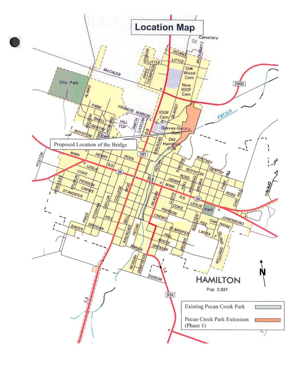
125 E-2
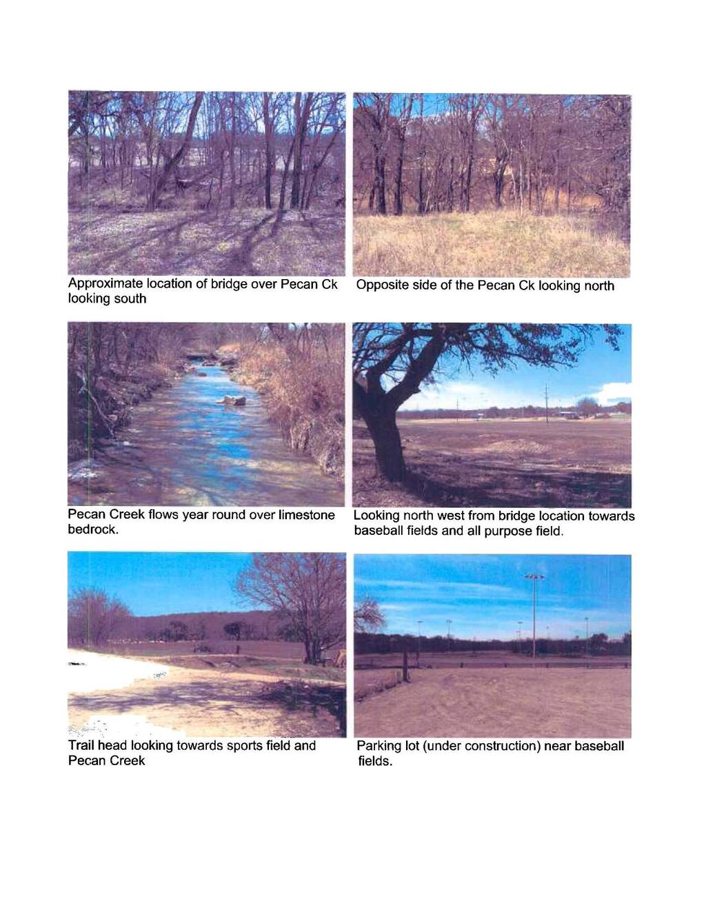
126 E-3
GEOMETRIC DESIGN CRITERIA for Non-freeway Resurfacing, Restoration, and Rehabilitation Projects
 GEOMETRIC DESIGN CRITERIA for Non-freeway Resurfacing, Restoration, and Rehabilitation Projects SEPTEMBER 1989 Arkansas State Highway and Transportation Department GEOMETRIC DESIGN CRITERIA for Non-freeway
Historic Bridge Adoption Information Packet. Medina County CR 662 Francisco Perez Creek
 Historic Bridge Adoption Information Packet Medina County CR 662 Francisco Perez Creek April 16, 2018 Table of Contents Announcement... 3 Bridge Location... 4 Bridge Information... 4 Bridge Condition and
THE COMMONWEALTH OF MASSACHUSETTS NON-NHS BRIDGE R&R POLICY
 THE COMMONWEALTH OF MASSACHUSETTS Number: P-92-010 Date: 10-08-92 - ) HIGHWAY DEPARTMENT FROM: NON-NHS BRIDGE R&R POLICY The purpose of this Engineering Directive is to formally notify Department Personnel
SAN ANTONIO STREET BRIDGE AT COMAL RIVER. Open House
 SAN ANTONIO STREET BRIDGE AT COMAL RIVER Open House May 1, 2018 SAN ANTONIO STREET BRIDGE AT COMAL RIVER, NEW BRAUNFELS COMAL COUNTY OPEN HOUSE MAY 1, 2018 5:00 P.M 7:00 P.M. New Braunfels Civic/Convention
State Level Historic Documentation Report. Poca Truss Bridge Roane County
 State Level Historic Documentation Report State Project No. S344-13-7.42 Federal Project No. ACST-0013(062)D Poca Truss Bridge Roane County Prepared by: Randy Epperly, Historian Department of Transportation
Chapter 1. General Design Information. Section 1.02 Structure Selection and Geometry. Introduction
 Chapter 1 Bridge Design Manual General Design Information Section 1.02 Selection and Geometry Introduction Selection or Rehabilitation Report This section of the design manual provides guidance on the
CHAPTER 3 SCOPE SUMMARY
 CHAPTER 3 SCOPE SUMMARY GENERAL The SDDOT is an active member of AASHTO to share common national design standards for the state highway system. The AASHTO Task Force on Geometric Design has completed the
STRUCTURE AND BRIDGE DIVISION
 Sheet 1 of 8 VIRGINIA DEPARTMENT OF TRANSPORTATION STRUCTURE AND BRIDGE DIVISION INSTRUCTIONAL AND INFORMATIONAL MEMORANDUM GENERAL SUBJECT: State of Good Repair Bridge Project Selection and Eligible Work
Conceptual Design Report
 Conceptual Design Report I-244/Arkansas River Multimodal Bridge Tulsa, Oklahoma Prepared for the Oklahoma Department of Transportation Prepared by: August 2009 I-244 / ARKANSAS RIVER MULTIMODAL BRIDGE
Definitions 3/3/2010. Choosing the Select: The Results of the Indiana Historic Bridge Inventory. Road School 2010
 Choosing the Select: The Results of the Indiana Historic Bridge Inventory Road School 2010 Definitions Historic bridge: A bridge that is listed in, or eligible for listing in, the National Register of
Report on. Texas Bridges. as of September Prepared by the Bridge Division Texas Department of Transportation
 Report on Texas Bridges as of September 2003 Prepared by the Bridge Division Texas Department of Transportation Printed April 30, 2004 Austin, Texas Copies of this publication have been deposited with
REHABILITATION PACKAGE 4-a
 4-a WINONA BRIDGE (BRIDGE 5900) REHABILITATION PACKAGE 4-a Rehab option 4-a is a rehabilitation package whereby all spans of the existing steel truss structure would be rehabilitated and strengthened.
TABLE OF CONTENTS. Manual Section. Introduction 1. Using This Manual 2-3. Administrative Actions 4-6. Road and Bridge Project Types 7
 ii TABLE OF CONTENTS Manual Section Pages Introduction 1 Using This Manual 2-3 Administrative Actions 4-6 Road and Bridge Project Types 7 Road and Bridge Funding Programs 8-9 Project Planning and Eligible
Chester Bridge Environmental Assessment (EA) CAG Meeting #2. October 12, 2017
 CAG Meeting #2. October 12, 2017") Chester Bridge Environmental Assessment (EA) CAG Meeting #2 October 12, 2017 Agenda Introductions Purpose & Need review and Merger Approval Review of the Conceptual Alternatives Recap of the Public Meeting
Chester Bridge Environmental Assessment (EA) CAG Meeting #2 October 12, 2017 Agenda Introductions Purpose & Need review and Merger Approval Review of the Conceptual Alternatives Recap of the Public Meeting
An Overview and Comparison of the Tennessee Department of Transportation s Environmental Evaluation Process
 Introduction This document provides a brief overview of the policy and procedures that govern the environmental evaluation process that the Tennessee Department of Transportation (TDOT) must follow for
CHAPTER 18 TEMPORARY ROADS AND BRIDGES
 Change #1 - Revised 12/12 CHAPTER 18 TEMPORARY ROADS AND BRIDGES 18.0 INTRODUCTION These guidelines are to be used to design temporary roads and bridges where traffic will be maintained at the construction
Historic Bridge Adoption Information Packet
 Historic Bridge Adoption Information Packet Harris County Navigation Boulevard Underpass Bridge Commerce Street and Houston Belt & Terminal Railroad over Navigation Boulevard May, 2018 Table of Contents
Preserva on Assessment
 Preserva on Assessment For Seidersville Road Bridge over Saucon Creek BMS # 48 7301 0000 9019 Northampton County PennDOT Engineering District 5 0 Final Report June 2016 Prepared by TranSystems for the
MINNESOTA ARCHITECTURE - HISTORY INVENTORY FORM
 Identification Historic Name Bridge 5388 Current Name Bridge R0529 Field # Address State Highway 2 over the Little Iowa River City/Twp LeRoy Township County Mower Legal Desc. Twp 101N Range 14W Sec 21
Draft. WHEREAS, the MDT participated in the consultation and has been invited to concur in this Programmatic Agreement; and
 Draft PROGRAMMATIC AGREEMENT AMONG THE FEDERAL HIGHWAY ADMINISTRATION, THE ADVISORY COUNCIL ON HISTORIC PRESERVATION AND THE MONTANA STATE HISTORIC PRESERVATION OFFICE AFFECTING HISTORIC ROADS AND BRIDGES
6 th STREET VIADUCT SIESMIC IMPROVEMENT PROJECT
 6 th STREET VIADUCT SIESMIC IMPROVEMENT PROJECT Project Location The 6 th Street Viaduct (Bridge No. 53C-1880) and Sixth Street Overcrossing (Bridge No. 53-0595) comprise a single structure, which spans
LOCATION AND DESIGN DIVISION
 VIRGINIA DEPARTMENT OF TRANSPORTATION LOCATION AND DESIGN DIVISION INSTRUCTIONAL AND INFORMATIONAL MEMORANDUM GENERAL SUBJECT: Design Exceptions / Waivers SPECIFIC SUBJECT: Design Exception Request Form
Oklahoma Department of Transportation Environmental Programs Division Office Fax
 Oklahoma Department of Transportation Environmental Programs Division Office 521-3050 Fax 522-5193 Documented Categorical Exclusion (DCE) for I-40: Pavement Reconstruction and Added Lanes from the Douglas
Rapid City, SD HDR Project No RE: Replacement of Existing I-190 Twin Bridges at I-190/Silver Street Interchange, Rapid City, SD
 To: Steve Gramm, SDDOT Memo From: HDR Project: SDDOT I-190 Silver Street Interchange Study Rapid City, SD HDR Project No. 000000000137390 Date: December 27, 2011 RE: Replacement of Existing I-190 Twin
MINNESOTA HISTORIC PROPERTY RECORD PART I. PROPERTY IDENTIFICATION AND GENERAL INFORMATION
 MINNESOTA HISTORIC PROPERTY RECORD PART I. PROPERTY IDENTIFICATION AND GENERAL INFORMATION Common Name: Camp Ripley Bridge Bridge Number: 4969 Identification Number: Location: Feature Carried: TH 115 Feature
Evaluation of Rehabilitation Alternatives for the Cedar Avenue Bridge
 Evaluation of Rehabilitation Alternatives for the Cedar Avenue Bridge Mn/DOT Bridge No. 3145 Prepared for Minnesota Department of Transportation and City of Bloomington, Minnesota Prepared by www.meadhunt.com
CHAPTER 4 GRADE SEPARATIONS AND INTERCHANGES
 CHAPTER 4 GRADE SEPARATIONS AND INTERCHANGES 4.0 INTRODUCTION The ability to accommodate high volumes of intersecting traffic safely and efficiently through the arrangement of one or more interconnecting
Exhibit A Mn/DOT Contract No
 Exhibit A Mn/DOT Contract No. 98142 SCOPE OF WORK AND DELIVERABLES Preliminary Design Red Wing US 63 Bridge and Approach Roadways State Project (SP) 2515-21 SCOPE OVERVIEW... 2 SCHEDULE... 2 PROJECT TASK
FINAL Rehabilitation and Replacement Strategy Analysis Report
 FINAL Rehabilitation and Replacement Strategy Analysis Report Bridge Street at Arroyo Grande Creek Bridge Existing Bridge No. 49C-0196 Bridge Rehabilitation and Replacement Project Federal Project No.
Clear Creek Road (PM 1.82 & 0.25) Bridge Replacement Projects. Public Meeting, Wednesday, November 20, 2013 Pleasant Valley Middle School
 Bridge Replacement Projects. Public Meeting, Wednesday, November 20, 2013 Pleasant Valley Middle School") Clear Creek Road (PM 1.82 & 0.25) Bridge Replacement Projects Public Meeting, Wednesday, November 20, 2013 Pleasant Valley Middle School Presented By: County of El Dorado Community Development Agency Transportation
Clear Creek Road (PM 1.82 & 0.25) Bridge Replacement Projects Public Meeting, Wednesday, November 20, 2013 Pleasant Valley Middle School Presented By: County of El Dorado Community Development Agency Transportation
SECTION 4(f) EVALUATION ALASKA RAILROAD MOODY TUNNEL REMOVAL FEDERAL TRANSIT ADMINISTRATION U.S. Department of Transportation
 EVALUATION ALASKA RAILROAD MOODY TUNNEL REMOVAL FEDERAL TRANSIT ADMINISTRATION U.S. Department of Transportation") SECTION 4(f) EVALUATION ALASKA RAILROAD MOODY TUNNEL REMOVAL FEDERAL TRANSIT ADMINISTRATION U.S. Department of Transportation INTRODUCTION This has been prepared in compliance with the requirements of
SECTION 4(f) EVALUATION ALASKA RAILROAD MOODY TUNNEL REMOVAL FEDERAL TRANSIT ADMINISTRATION U.S. Department of Transportation INTRODUCTION This has been prepared in compliance with the requirements of
Preserva on Assessment
 Preserva on Assessment For Upham Road Bridge over Gaylord Creek BMS # 57 7221 0498 0130 Susquehanna County PennDOT Engineering District 4 0 Final Report Dec 2017 Prepared by TranSystems for the Pennsylvania
Minnesota Department of Transportation (Mn/DOT) Historic Bridge Management Plan
 Historic Bridge Management Plan") Minnesota Department of Transportation (Mn/DOT) Historic Bridge Management Plan Executive Summary Bridge Number: 4969 Bridge 4969, the Camp Ripley Bridge, was built in 1930 to carry vehicular traffic on
Minnesota Department of Transportation (Mn/DOT) Historic Bridge Management Plan Executive Summary Bridge Number: 4969 Bridge 4969, the Camp Ripley Bridge, was built in 1930 to carry vehicular traffic on
PROJECT SCOPING PHASE ~ SCOPE OF SERVICES MAIN STREET BRIDGE OVER WINOOSKI RIVER CITIES OF BURLINGTON & WINOOSKI VERMONT
 PROJECT SCOPING PHASE ~ SCOPE OF SERVICES MAIN STREET BRIDGE OVER WINOOSKI RIVER CITIES OF BURLINGTON & WINOOSKI VERMONT PROJECT DESCRIPTION McFarland-Johnson, Inc. (MJ) has prepared this proposal to perform
GUIDE FOR THE PREPARATION OF TRAFFIC IMPACT STUDIES
 GUIDE FOR THE PREPARATION OF TRAFFIC IMPACT STUDIES Adopted by Town Council on November 25, 2008 Prepared By: HNTB Engineering Department Planning Department TABLE OF CONTENTS I. INTRODUCTION... 1 II.
APPENDIX B. Public Works and Development Engineering Services Division Guidelines for Traffic Impact Studies
 APPENDIX B Public Works and Development Engineering Services Division Guidelines for Traffic Impact Studies Revised December 7, 2010 via Resolution # 100991 Reformatted March 18, 2011 TABLE OF CONTENTS
Preserva on Assessment
 Preserva on Assessment For Sheep Hole Road over Tinicum Creek BMS # 09 7009 0432 0361 Bucks County PennDOT Engineering District 6 0 Final Report Dec 2017 Prepared by TranSystems for the Pennsylvania Department
5.D.1 HISTORIC, ARCHITECTURAL, ARCHEOLOGICAL, AND CULTURAL RESOURCES
 5.D.1 HISTORIC, ARCHITECTURAL, ARCHEOLOGICAL, AND CULTURAL RESOURCES Section 106 of the National Historic Preservation Act (NHPA) of 1966, as amended (16 U.S.C. Section 470(f)) protects properties that
Preparing a Reevaluation Using the Documented Reevaluation Checklist (DRC)
") Guidance Preparing a Reevaluation Using the Documented This guidance outlines the TxDOT process for preparing a documented reevaluation as required by 43 TAC 2.85 and 23 CFR 771.129. TxDOT Environmental
Guidance Preparing a Reevaluation Using the Documented This guidance outlines the TxDOT process for preparing a documented reevaluation as required by 43 TAC 2.85 and 23 CFR 771.129. TxDOT Environmental
Preserva on Assessment
 Preserva on Assessment For Mill Road over Neshaminy Creek BMS # 09 7009 0381 0127 Bucks County PennDOT Engineering District 6 0 Final Report Dec 2017 Prepared by TranSystems for the Pennsylvania Department
Lubbock Outer Route Feasibility Study Report Executive Summary
 Lubbock Outer Route Feasibility Study Report Executive Summary Prepared for: Texas Department of Transportation Lubbock District Prepared by: MACTEC Engineering and Consulting, Inc. 6701 Aberdeen, Suite
Designing Bridges for Inspectability
 Designing Bridges for Inspectability Sreenivas Alampalli 1 and Arthur P. Yannotti 2 1 New York State Department of Transportation 50 Wolf Road, Albany, NY 12232 (518) 457-5498; salampalli@dot.state.ny.us
FEDERAL HIGHWAY ADMINISTRATION RECORD OF DECISION FOR THE LYNNWOOD LINK EXTENSION
 FEDERAL HIGHWAY ADMINISTRATION RECORD OF DECISION FOR THE LYNNWOOD LINK EXTENSION AUGUST 2015 Table of Contents 1 Decision... 1 1.1 Project Description... 2 1.2 Basis for the FHWA Decision... 7 1.2.1
NEPA THE NATIONAL ENVIRONMENTAL PROTECTION ACT CEQA THE CALIFORNIA ENVIRONMENTAL QUALITY ACT
 NEPA THE NATIONAL ENVIRONMENTAL PROTECTION ACT Enacted in 1969 to provide review of Federal projects to identify significant impacts. NEPA applies to a project that requires discretionary actions by a
1.0 NEED AND PURPOSE FOR THE PROPOSED PROJECT
 0 0.0 NEED AND PURPOSE FOR THE PROPOSED PROJECT The Harbor Bridge is located on US Highway (US ) approximately one-half mile north of the US and Interstate Highway (I-) interchange in Corpus Christi, Texas
The Norwich Street Bridge
 The Norwich Street Bridge Class Environmental Assessment Open House May 17, 2017 6:30-8 p.m. Guelph City Hall Phase 1 Phase 2 Project File Our Study Process: This study is being undertaken as a Schedule
Work Breakdown Structure Element Dictionary Preliminary Engineering
 Element Name Initiation PE 3.1 Initiation includes the implementation of the project s funding and notification of the consultant or in-house design staff to commence work, the Kickoff Meeting with the
LOCATION AND DESIGN DIVISION
 VIRGINIA DEPARTMENT OF TRANSPORTATION LOCATION AND DESIGN DIVISION INSTRUCTIONAL AND INFORMATIONAL MEMORANDUM GENERAL SUBJECT: Interstate, NHS Non-Interstate and Non-NHS (IJR / IMR Guidance) SPECIFIC SUBJECT:
Preserva on Assessment
 Preserva on Assessment For Bardo Road Over Li le Fishing Creek BMS # 19 7209 0536 0089 Columbia County PennDOT Engineering District 3 0 Prepared by TranSystems Final Report Dec 2017 for the Pennsylvania
The FHWA Long-Term Bridge Performance Program
 The FHWA Long-Term Bridge Performance Program by John M. Hooks, J. M. Hooks & Associates An ever-growing volume of cars and trucks move people and goods on modern bridges spanning highways and topographical
STANDARDIZED CONCRETE BRIDGES IN TEXAS. John Holt, PE, Texas Department of Transportation Ronald Medlock, PE, Texas Department of Transportation
 STANDARDIZED CONCRETE BRIDGES IN TEXAS John Holt, PE, Texas Department of Transportation Ronald Medlock, PE, Texas Department of Transportation ABSTRACT Standardized concrete bridge plans are used extensively
Preserva on Assessment
 Preserva on Assessment For Ftorkowski Road Bridge over Hun ngton Creek BMS # 40 7217 0482 6006 Luzerne County PennDOT Engineering District 4 0 Final Report June 2016 Prepared by TranSystems for the Pennsylvania
ARROWS RANSPORTATION LAN
 ARROWS RANSPORTATION LAN Developed by the Transportation Planning Division Of the Virginia Department of Transportation In Cooperation With The U.S. Department Of Transportation, Federal Highway Administration
AMERICAN ASSOCIATION OF STATE HIGHWAY AND TRANSPORTATION OFFICIALS, CENTER FOR ENVIRONMENTAL EXCELLENCE, HISTORIC BRIDGES COMMUNITY OF PRACTICE
 AMERICAN ASSOCIATION OF STATE HIGHWAY AND TRANSPORTATION OFFICIALS, CENTER FOR ENVIRONMENTAL EXCELLENCE, HISTORIC BRIDGES COMMUNITY OF PRACTICE HISTORIC BRIDGE REHABILITATION AND MAINTENANCE CASE STUDY
DOUGLAS COUNTY ZONING RESOLUTION Section 17 Wildfire Hazard - Overlay District 3/10/99. -Section Contents-
 SECTION 17 WILDFIRE HAZARD - OVERLAY DISTRICT -Section Contents- 1701 Intent... 17-2 1702 Definitions... 17-2 1703 Applicability... 17-5 1704 Wildfire Hazard Overlay District Map... 17-6 1705 Wildfire
Preserva on Assessment
 Preserva on Assessment For Walp Road over Nescopeck Creek BMS # 40 7230 0342 7312 Luzerne County PennDOT Engineering District 4 0 Final Report Dec 2017 Prepared by TranSystems for the Pennsylvania Department
Traffic Technical Memorandum: Hickman Road over Tuolumne River Bridge Replacement Project, Stanislaus County (BRLO-5938(199))
)") 11060 White Rock Road, Suite 200 Rancho Cordova, CA 95670 Phone: (916) 363-4210 Fax: (916) 363-4230 M e m o r a n d u m To: Reena Gohil, Environmental Planner Date: May 30, 2017 California Department of
11060 White Rock Road, Suite 200 Rancho Cordova, CA 95670 Phone: (916) 363-4210 Fax: (916) 363-4230 M e m o r a n d u m To: Reena Gohil, Environmental Planner Date: May 30, 2017 California Department of
Inventory Methodology for Oklahoma Depression-era Bridges and Bridgeclass
 Inventory Methodology for Oklahoma Depression-era Bridges and Bridgeclass Culverts (interim final) Prepared for Oklahoma Department of Transportation Prepared by www.meadhunt.com December 2012 Table of
Selecting Projects for Accelerated Bridge Construction
 Selecting Projects for Accelerated Bridge Construction In January of 2017, the Engineering Services and Operations Division Directors issued a memo instructing Districts to consider accelerated bridge
General Guidelines for the Preparation of Traffic Impact Studies
 ENGINEERING & OPERATIONS DIVISION General Guidelines for the Preparation of Traffic Impact Studies April 2010 Prepared by: Highway Planning and Design Branch Table of Contents 1. INTRODUCTION 1 2. TRAFFIC
Cochran Mill Road Bridge over Tuscarora Creek
 Cochran Mill Road Bridge over Tuscarora Creek July 15, 2014 Brian Morrison, P.E. NOVA District Senior Structural Engineer (703) 259-2606 brian.morrison@vdot.virginia.gov Purpose & Need Purpose Update project
NJTPA 2014 Local Concept Development Study Hudson & Essex Counties Clay Street Bridge over the Passaic River. Public Information Center
 NJTPA 2014 Local Concept Development Study Hudson & Essex Counties Clay Street Bridge over the Passaic River Public Information Center June 24, 2015 PROJECT STATUS Study Began January 2014 Data collection
Austin Avenue Bridges Project Walking Tour Agenda
 Agenda Event Start End Introductions and Overview 9:00 Environmental Process Section 106 and Consulting Parties Historic Significance of Bridges Project Background Bridge Components Bridge Conditions 9:30
Public Meeting. US Highways 18 & 281 and SD Highway 50 From Douglas County Line to SD46 Charles Mix County
 Public Meeting US Highways 18 & 281 and SD Highway 50 From Douglas County Line to SD46 Charles Mix County Cary Cleland Road Design Engineering Supervisor January 17, 2017 Project Limits US18/US281 US281
Feasibility Assessment Study
 August 19, 2010 Feasibility Assessment Study Historic Sites Council Meeting Today s Agenda Historic Overview Project Overview Barrier Issues Concrete Parapet Recommendations Steel Parapet Recommendations
Interstate 73 FEIS: I-95 to the Myrtle Beach Region Chapter 4. Public Involvement and Agency Coordination
 4-65 Interstate 73 FEIS: I-95 to the Myrtle Beach Region 4-66 Comment noted. The use of existing roadways was considered during alternative development (refer to Chapter 2, Section 2.1, page 2-1 and the
BRIDGE INSPECTION REPORTS 101. Protecting Your Bridge Inventory for the Future Jason Kelly, PE
 BRIDGE INSPECTION REPORTS 101 Protecting Your Bridge Inventory for the Future Jason Kelly, PE >> Presentation Overview Program History Data Collection Reporting Sufficiency Rating 5/26/2016 Bridge Inspection
MASTER AGREEMENT FOR BRIDGE DESIGN SERVICES SCOPE OF WORK
 MASTER AGREEMENT FOR BRIDGE DESIGN SERVICES SCOPE OF WORK The professional services to be provided by the Consultant under this Agreement shall be as necessary to complete the required analyses, layouts,
STATE OF NEW HAMPSHIRE DEPARTMENT OF TRANSPORTATION LOAD RATING REPORT GENERAL SULLIVAN BRIDGE - DOVER 200/023 OVER THE LITTLE BAY
 STATE OF NEW HAMPSHIRE DEPARTMENT OF TRANSPORTATION LOAD RATING REPORT GENERAL SULLIVAN BRIDGE - DOVER 200/023 OVER THE LITTLE BAY NEWINGTON-DOVER, 11238S August 15, 2016 Vanasse Hangen Brustlin, Inc.
Red Wing Bridge Alternates
 Alternate 1 Tied Arch Alternate 2 Simple Span Truss Alternate 1 Design Drawing Alternate 2 Design Drawing Similar Bridge Design to Alternate 1 Similar Bridge Design to Alternate 2 Evaluation Matrix for
CLA /10.54, PID Project Description:
 Project Description: The proposed project will consist of widening IR 70 to three lanes from Enon Road (SLM 06.75) to the US 68 interchange ramps (SLM 10.55). IR 70 is a component of the Strategic Highway
Appendix E-1. FDOT MPO Program Management Handbook. (Excerpts)
") Appendix E-1 FDOT MPO Program Management Handbook (Excerpts) TABLE OF CONTENTS Chapter 4 Long-Range Transportation Plan Section Page 4.1 PURPOSE... 4-2 4.2 AUTHORITY... 4-2 4.3 SCOPE... 4-2 4.4 REFERENCES...
Appendix E-1 FDOT MPO Program Management Handbook (Excerpts) TABLE OF CONTENTS Chapter 4 Long-Range Transportation Plan Section Page 4.1 PURPOSE... 4-2 4.2 AUTHORITY... 4-2 4.3 SCOPE... 4-2 4.4 REFERENCES...
Bridge Inspection Manual. Revised July 2002 by Texas Department of Transportation (512) all rights reserved
 all rights reserved") Bridge Inspection Manual Revised July 2002 by Texas Department of Transportation (512) 416-2055 all rights reserved Bridge Inspection Manual July 2002 Manual Notices Manual Notice 2002-1 To: From: Manual:
Bridge Inspection Manual Revised July 2002 by Texas Department of Transportation (512) 416-2055 all rights reserved Bridge Inspection Manual July 2002 Manual Notices Manual Notice 2002-1 To: From: Manual:
2.0 Purpose. 3.0 Work Plan. Page 1 of 7
 2.0 Purpose The purpose of this document is to present the findings of the field investigation and concept design study, as well as recommend appropriate track relocation and bridge modifications to provide
APPENDIX G Enviromental Documents
 APPENDIX G Enviromental Documents CACHE CREEK APN 060-230-007 LOWREY KATHERINE A ETAL 5.20 ACRES APN 060-230-009 FACCIUTO VINCENT R & VICTORIA 7.78 ACRES APN 060-251-001 LLOYD TRUST ETAL & LLOYD FAM REV
Introduction. Background
 Example Transportation Asset Management Plan Outline This outline was created using the Transportation Asset Management Plan (TAMP) Builder ( www.tamptemplate.org ), a product of NCHRP Project 8-36/116.
Research Initiatives at TxDOT Related to Utilities and Right of Way
 Research Initiatives at TxDOT Related to Utilities and Right of Way Transportation Research Board Workshop on Transportation Law, New Orleans, LA July 17, 2012 Overview 2 TxDOT utility/right of way research
Appendix Q Draft Location Hydraulic Study Report For the State Route 32 Widening Between Fir Street and Yosemite Drive at Dead Horse Slough and South
 Appendix Q Draft Location Hydraulic Study Report For the State Route 32 Widening Between Fir Street and Yosemite Drive at Dead Horse Slough and South Fork Dead Horse Slough in the, California Draft Location
PROGRAMMATIC SECTION 4(f) EVALUATION
 EVALUATION") 7 LA 1 PM 42.3/44.7 0A3800, Santa Monica, CA PROGRAMMATIC SECTION 4(f) EVALUATION Submitted Pursuant to: 49 USC 303 THE STATE OF CALIFORNIA Department of Transportation as assigned Date of Approval Gary
7 LA 1 PM 42.3/44.7 0A3800, Santa Monica, CA PROGRAMMATIC SECTION 4(f) EVALUATION Submitted Pursuant to: 49 USC 303 THE STATE OF CALIFORNIA Department of Transportation as assigned Date of Approval Gary
BRIDGE INSPECTION REPORT
 NC DEPARTMENT OF TRANSPORTATION ATTENTION DIVISION OF HIGHWAYS BRIDGE MANAGEMENT UNIT BRIDGE INSPECTION REPORT INSPECTION TYPE: Routine Inspection COUNTY IREDELL BRIDGE NUMBER 480596 INSPECTION CYCLE 2
New Jersey Department of Transportation. Local Freight Impact Fund Handbook. Procedures and Criteria for Local Freight Impact Fund Grant Program
 New Jersey Department of Transportation Local Freight Impact Fund Handbook Procedures and Criteria for Local Freight Impact Fund Grant Program Page 1 of 10 Overview The New Jersey Department of Transportation
Bridge Barrier Development Presentation to the MFLNRO April John Deenihan Ph.D., EIT Julien Henley M.A.Sc., P.Eng
 Bridge Barrier Development Presentation to the MFLNRO April 2014 John Deenihan Ph.D., EIT Julien Henley M.A.Sc., P.Eng Contents Introduction Contents Introduction Background Information / Synopsis Contents
Maclay Bridge Preservation Alternatives Analysis
 Maclay Bridge Preservation Alternatives Analysis Bitterroot River W of Missoula BR 9032(65) UPN 6296000 August 30, 2018 Maclay Bridge Preservation Alternatives Analysis August 30, 2018 Table of Contents
Get Involved Design Public Hearing
 Get Involved Design Public Hearing VDOT representatives will review and evaluate Mail comments to Mr. Vicente Valeza at the address John G. Lewis Memorial Bridge any information received as a result of
Table Table 7.2 Potential Environmental Impacts and Mitigation Measures
 7.2 Natural Environment/Environmental Planning Executive Summary/Key Points The Environmental Consultation and Mitigation Plan establishes: o A process for consultation with environmental resource agencies
Guideline for Bridge Safety Management February 2012
 Guideline for Bridge Safety Management February 2012 Table of Contents Foreword Part A General 0.1 Definitions 0.2 Scope 0.3 Application 0.4 Responsibility Part B Bridge Safety Assurance 1.1 Scope 1.2
Preliminary Project Assessment
 DISCLAIMERS: Date: March 14, 2014 Case No.: 2014.0097U Project Address: Third Street Crossing of Islais Creek Block/Lot: Public Right-of-Way Zoning: Not Applicable Area Plan: Not Applicable Project Sponsor:
Categorical Exclusion Programmatic Agreement Between the Federal Highway Administration And the Indiana Department of Transportation
 Categorical Exclusion Programmatic Agreement Between the Federal Highway Administration And the Indiana Department of Transportation Introduction The Indiana Department of Transportation (INDOT) and the
PUBLIC HEARING LOOP 9
 PUBLIC HEARING LOOP 9 From Interstate (I)-35E to I-45 Dallas and Ellis Counties, Texas CSJ: Loop 2964-10-005 9: I-35E to I-45 Tuesday, June 20, 20, 2017 2017 Public Hearing Introductions ELECTED & PUBLIC
D.R. Maniar, M. D. Engelhardt, and D.E. Leary Research Report Project conducted in cooperation with the U.S. Department of Transportation
 Technical Report Documentation Page 1. Report No. 2. Government Accession No. 3. Recipient s Catalog No. FHWA/TX-03/1741-3 4. Title and Subtitle 5. Report Date Evaluation and Rehabilitation of Historic
Northeast Bridge Preservation Partnership Meeting
 Northeast Bridge Preservation Partnership Meeting Superstructure Preservation Strategies Aetna Viaduct Superstructure Repairs Route I-84 City of Hartford, CT State Project No. 63-648 David A. Cutler, P.E.
7 Transportation Improvement strategies
 7-1 7 Transportation Improvement strategies Based on analyses conducted during the course of the /I-10 Feasibility Study, it was determined that various alternatives for improving the entire corridor to
Minnesota Department of Transportation (MnDOT) Local Historic Bridge Report
 Local Historic Bridge Report") Executive Summary Bridge 3130, constructed in 1920, carries Township Road 232 over the Blue Earth River about one-half mile south of Blue Earth in rural southwestern Faribault County. Blue Earth City Township
Executive Summary Bridge 3130, constructed in 1920, carries Township Road 232 over the Blue Earth River about one-half mile south of Blue Earth in rural southwestern Faribault County. Blue Earth City Township
CONNECTICUT HISTORIC BRIDGE INVENTORY FINAL REPORT: PRESERVATION PLAN. Federal Aid Project # HPR-PR-1(27) Submitted to
 Submitted to") CONNECTICUT HISTORIC BRIDGE INVENTORY FINAL REPORT: PRESERVATION PLAN Federal Aid Project # HPR-PR-1(27) Submitted to Connecticut Department of Transportation Office of Environmental Planning May 1991
CONNECTICUT HISTORIC BRIDGE INVENTORY FINAL REPORT: PRESERVATION PLAN Federal Aid Project # HPR-PR-1(27) Submitted to Connecticut Department of Transportation Office of Environmental Planning May 1991
Public Meeting. SD 37 James River Bridge Beadle County P 0037(140)140 PCN 04FH. Steve Johnson, PE Chief Bridge Design Engineer.
140 PCN 04FH. Steve Johnson, PE Chief Bridge Design Engineer.") Public Meeting SD 37 James River Bridge Beadle County P 0037(140)140 PCN 04FH Steve Johnson, PE Chief Bridge Design Engineer August 9, 2016 Purpose of the Meeting Provide a Project Overview Background
Public Meeting SD 37 James River Bridge Beadle County P 0037(140)140 PCN 04FH Steve Johnson, PE Chief Bridge Design Engineer August 9, 2016 Purpose of the Meeting Provide a Project Overview Background
Transportation Conformity Guidance for Qualitative Hot-spot Analyses in PM 2.5 and PM 10 Nonattainment and Maintenance Areas
 Transportation Conformity Guidance for Qualitative Hot-spot Analyses in PM 2.5 and PM 10 Nonattainment and Maintenance Areas United States Environmental Protection Agency Federal Highway Administration
OPTIONAL STATIONAVIATION/MANCHESTER
 CRENSHAW/LAX TRANSIT CORRIDOR PROJECT FEIS/FEIR OPTIONAL STATIONAVIATION/MANCHESTER Aviation and Manchester, Looking East Aviation/Manchester Station (Optional) The Optional Aviation/Manchester Station
A Framework for Historic Bridge Preservation in Tarrant County
 TTI: 409139 A Framework for Historic Bridge Preservation in Tarrant County Technical Report 409139-1 Cooperative Research Program TEXAS A&M TRANSPORTATION INSTITUTE COLLEGE STATION, TEXAS in cooperation
Winona Bridge Work Package #6. Options Overview
 Winona Bridge Work Package #6 Bridge No. 5900 (Existing Bridge) Approach Span Reconstructions Options Overview May 29, 2016 Background The scope of work on the Winona Bridge project consists of new Bridge
PRACTITIONER S HANDBOOK
 AASHTO PRACTITIONER S HANDBOOK 03 August 2016 MANAGING THE NEPA PROCESS FOR TOLL LANES AND TOLL ROADS This Handbook provides recommendations for conducting National Environmental Policy Act (NEPA) studies