Using the ForWarn System
|
|
|
- Barnard Chandler
- 6 years ago
- Views:
Transcription

1
2
3 Highlights of Satellite-Based Forest Change Recognition and Tracking Using the ForWarn System Steven P. Norman, William W. Hargrove, Joseph P. Spruce, William M. Christie, and Sean W. Schroeder
4 ii Table of Contents Abstract Introduction The Technology Overview of Forest Changes HIGHLIGHTS Heavy Snowpack Early Frost Tornadoes and Hail Hurricanes Drought Wildfires Insect Defoliation Development and Deforestation Summary
5 Abstract Satellite-based remote sensing can assist forest managers with their need to recognize disturbances and track recovery. Despite the long standing availability of raw imagery, the systematic delivery of spatially continuous, ready-to-use, processed products has evaded us until recently. The web-based ForWarn system moves us a step forward by generating forest change maps at high frequency in a format that is usable to forest managers, planners, and the public. The ForWarn system shows change in the Normalized Difference Vegetation Index derived from moderate resolution imagery according to a range of baseline normals. Expectations of normal derive from previously observed changes in seasonal leaf phenology; this adjustment is critical for forests dominated by deciduous vegetation that vary in greenness through the year. After these seasonal adjustments are made behind the scene, the remaining forest change that ForWarn users see may result from an array of climatic and disturbance causes. These include insects and disease, wildland fire, wind, hail, human development, drought, or variation in the timing of spring and fall. This publication outlines the data and methods that underlie this technology, and provides examples that illustrate selected capabilities of this system for coarse-scale forest monitoring. Keywords: Disturbance, monitoring, phenology, recovery, remote sensing.
6 2 Satellite-Based Forest Change Recognition and Tracking Introduction Forest conditions can change rapidly from violent storms, severe fire or human development, but they can also change gradually from the progressive effects of altered disturbance regimes, slow-acting stress, or the cumulative impact of multiple factors (fig. 1, 2). Forest monitoring is difficult because we want to know about rapid change as soon as it occurs, while not neglecting the slower changes that can easily go unnoticed. Satellite-based monitoring has long been used to monitor rapid and gradual forest change, but not as systematically as it could be. Regular, high frequency observations that are corrected for the confounding effects of clouds would provide meaningful insights into how background conditions change naturally with climate variation and across seasons. This is important for the accurate recognition of change. Diagnosing the cause or causes of change is the subsequent challenge. Fortunately, forest change assessment efforts can build on preexisting efforts. Thanks to Federal and State programs, we have specialized knowledge of wildfires, insects and diseases, and climatic stress. What these efforts lack is an overarching system for integrated monitoring, assessment, tracking and communication for those who need this information. The highlights of forest change presented in this document reveal the capabilities of an important part of just such a system: a satellite-based change recognition and tracking system that leverages insights derived from these complementary, but specialized efforts.

7
8 4 Satellite-Based Forest Change Recognition and Tracking The Technology The National Early Warning System (EWS) is a coordinated effort to bring cutting-edge monitoring and assessment technologies and forest professionals together (Hargrove and others ). Today, technological advances allow us to systematically detect and track forest disturbances from space in near-real time, and a network of professionals is required to accurately interpret observations and communicate conditions to those who can take action, as appropriate. The core technology, ForWarn, is a satellite-based change recognition and tracking system developed by the Forest Service, USDA s Threat Assessment Centers, 2 and NASA Stennis Space Center, with substantive involvement by the U.S. Geological Survey, Department of Energy s Oak Ridge National Laboratory, and the University of North Carolina, Asheville s National Environmental Modeling and Analysis Center. ForWarn provides a strategic national overview of potential forest change which directs attention to places where forest behavior seems unusual or abnormal. These insights can help focus ground and aircraft observation efforts (such as those conducted by the Forest Service s National Insect and Disease Detection Survey program or post-disturbance response efforts). Operating since January 2010, ForWarn generates national disturbance maps covering the conterminous United States every eight days, even throughout the winter. It detects all types of forest disturbances, including insects, disease, wildfires, frost and ice damage, tornadoes, hurricanes, blow-downs, harvest, urbanization, and landslides. It also detects drought, flood, and other extreme climate effects and tracks early and delayed vegetation development during spring and fall. ForWarn uses the Normalized Difference Vegetation Index (NDVI) to measure vegetational vigor, or relative greenness. NDVI measures the degree to which solar radiation is differentially absorbed across red and infrared wavelengths due to the chlorophyll in plants. Reflectance data are obtained from the MODIS 3 sensors aboard NASA s Terra and Aqua satellites; 1 Hargrove, W.W.; Spruce, J.P.; Gasser, G.E.; Hoffman, F.M Toward a national early warning system for forest disturbances using remotely sensed canopy phenology. Photogrammetric Engineering & Remote Sensing. 75: [Date accessed: May 15, 2013] 2 The Eastern Forest Environmental Threat Assessment Center (EFETAC) is located in Asheville, NC, and the Western Wildland Environmental Threat Assessment Center (WWETAC) is in Prineville, OR. 3 Moderate Resolution Imaging Spectroradiometer.
9 Using the ForWarn System 5 these satellites provide a daily record of the condition of vegetation, when the view is not obstructed by smoke or clouds. The data are available at a nominal spatial resolution of 250 m, which translates to a map cell size of about 13 acres, or 5.4 ha (the equivalent to about 9 football fields each). While seemingly coarse compared to the dozens to hundreds of individual trees that normally exist within a single hectare of forest, finer resolution data do not exist at high frequency, and even with moderate resolution, this database grows by billions of data points each year. ForWarn works by comparing current conditions with the normal greenness that would be expected for healthy, undisturbed vegetation growing at a location during a given time of year. Locations that are currently less green than expected are marked as potentially disturbed (as indicated by shades of red, orange, and yellow on figure 3a and 3b on pages 6 7). Unfortunately, clouds can act to decrease the current observed greenness, mimicking the actions of forest disturbance agents. ForWarn overcomes this problem by relying on a moving 24-day window of daily satellite observations that nearly always provides a cloudless view. The moving window advances forward in eight day time steps. ForWarn also includes maps and time series graphs of raw NDVI values since Assessing forest change requires a historical baseline or multiple historical baselines of varying durations to determine how normal, healthy vegetation should appear. ForWarn utilizes three baselines (1) the prior year, (2) the maximum value of the last three years, and (3) the entire period of record. The maximum greenness value is kept from each of the 46 different 8-day time periods per year. Several of the forest change highlights in this document illustrate the insights that come from having a range of baselines for comparison. Forest change maps generated using ForWarn are available to anyone via the Forest Change Assessment Viewer, a Web-based tool that is accessible at New, near-real time maps are available at this Web site, as well as an archive of forest change products since 2000.
10

11
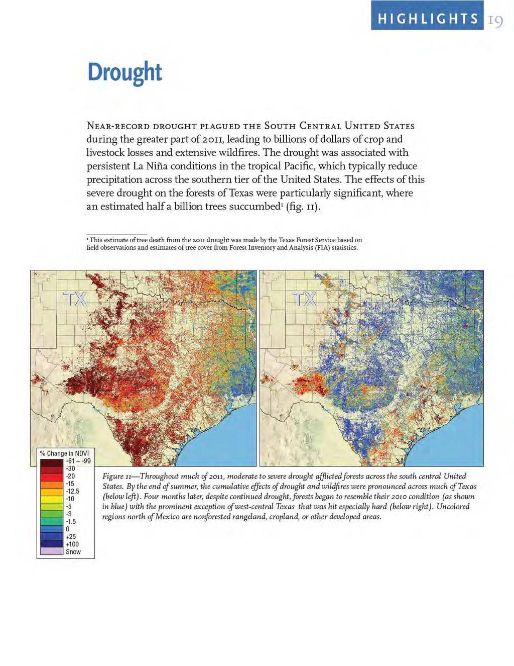
12 8 Satellite-Based Forest Change Recognition and Tracking Overview of Forest Changes Recent years have experienced remarkable forest disturbances and climate anomalies across the United States. Their co-occurrence has tested ForWarn s ability to detect disturbances during drought, and to map climate stress despite disturbance. For example, in 2011, extreme drought dominated much of the south-central and south-eastern United States. This drought was particularly strong in Texas where western portions of that State experienced extreme and prolonged drought that led to a sharp decline in rangeland productivity and a record outbreak of wildfires. Large fires also occurred from the ponderosa pine forests of eastern Arizona to the peaty forests of the Coastal Plain of Florida, North Carolina, and Virginia in areas that were and were not experiencing drought. Despite causing a directionally similar decline in greenness, ForWarn successfully distinguished wildfire from drought by mapping the relative severity of the decline. Earlier in 2011, spring was delayed across much of the United States by cool temperatures or an abnormally heavy snowpack. In the Southeast, the spring of 2011 brought one of the most notable tornado outbreaks in memory. Researchers used ForWarn to map tornado scars from these tornado outbreaks across northern Mississippi, Alabama, Tennessee, and Georgia. In contrast, 2012 experienced a remarkably early spring across the East due to early warm temperatures with fewer, yet still destructive tornadoes. ForWarn successfully detected these storm effects during both years. ForWarn has also detected defoliating insects across the United States. Particularly noteworthy examples of detected defoliation include the bald cypress forests of Louisiana; the ponderosa pine forests of South Dakota; the pine and fir forests of Montana, Idaho, and Washington; the northern hardwood forests of northwestern Pennsylvania; and the hemlockdominated forests of the Central and Southern Appalachians.
13 H I G H L I G H T S 9 Heavy Snowpack Winter snowpack has a major influence on spring flooding and water supplies, and snowpack can vary considerably from year to year. While ForWarn does not directly measure snowpack depth, it maps changes in snow cover compared to historical cover. 1 Heavy snowpacks can lower satellite-based measurements of NDVI either by temporarily obscuring evergreen vegetation or by delaying the spring greenup of deciduous grasses, herbs, shrubs, or trees. This snow-obscuring effect likely explains differences between December 2010 s high elevation forest anomalies in the Sierra Nevada and that of 2011 (fig. 4 on page 10). In high elevation and northern portions of the Northeast, spring was delayed by below average winter temperatures and the lingering heavy snowpack, despite March and April having normal to above-average temperatures 2 (fig. 5 on page 11). 1 For archival maps of snow cover and modeled snowpack, see the National Weather Service s National Operational Hydrologic Remote Sensing Center Web site located here: 2 Monthly temperature and precipitation departures from average for the United States are available on NOAA s climate monitoring Web site:

14

15

16 12 H I G H L I G H T S Early Frost The end of the growing season can be gradual or sudden in response to nuances of temperature and precipitation. In the Northeast, fall s onset is sensitive to the first frost. Progressively lower nighttime temperatures can lead to an extended fall, but unusually cold days or a series of cold days can lead to a rapid decline in observed NDVI measurements. These spatial and year to year differences are evident in ForWarn. The first severe frost in northern Minnesota, Wisconsin, and Michigan varies among years. In 2011, northeastern Minnesota experienced freezing temperatures on September 14, and the temperature dropped several degrees more the following night. In contrast, during 2010, widespread frost occurred on October 2, and a broad, killing frost occurred at the end of the month. 1 While mid-september frosts have occurred there in the past, 2011 s cold temperatures were reached relatively early (fig. 6). 1 RAWS climate data are from Meander, MN. See Joseph O Brien, USDA Forest Service

17

18

19

20

21

22
23

24

25

26

27

28

29

30

31 H I G H L I G H T S 27 Figure 19 The grey canopies in the background image are hemlocks that have succumbed to the hemlock woolly adelgid. ForWarn captured the rapid and widespread mortality of these evergreen trees by this invasive insect across the southern Appalachians in recent years. The time trace of 8 day NDVI from (see inset graph) shows how winter NDVI has progressively fallen for this area in Great Smoky Mountains National Park east of Gatlinburg, TN. This decline is due to the selective mortality of the evergreen component of this stand, which is most apparent during the winter months. The sudden drop in early 2010 was caused by a wet snow that covered branches and understory vegetation for weeks.
32

33
34 30 Summary ForWarn has successfully detected diverse climate and disturbance effects on forest vegetation. Climate effects include delayed spring greenup in the East, an early fall in the Midwest, the effects of an exceptionally severe drought in Texas, and an unusually heavy snowpack in the West. Despite variation in the climate-affected background condition, ForWarn successfully detected a range of local disturbances. These disturbances included the effects of tornadoes and windstorms in spring, variations in the severity of wildfires, the complex effects of a hurricane and tropical storm during regional drought, and defoliation and mortality from insects. ForWarn also detected deforestation associated with urbanization and mining among other drivers of forest change. ForWarn s near-real time and broad spatial approach to monitoring allows managers to systematically follow the progression of long-duration disturbances and recovery as readily as ephemeral disturbances that are detectable for only part of the growing season. This flexibility empowers forest managers and researchers to understand the condition and dynamics of forests across the United States.
35 Norman, S.P.; Hargrove, W.W.; Spruce, J.P. [and others] Highlights of satellitebased forest change recognition and tracking using the ForWarn System. Gen. Tech. Rep. SRS-180. Asheville, NC: U.S. Department of Agriculture Forest Service, Southern Research Station. 30 p. Satellite-based remote sensing can assist forest managers with their need to recognize disturbances and track recovery. Despite the long standing availability of raw imagery, the systematic delivery of spatially continuous, ready-to-use, processed products has evaded us until recently. The web-based ForWarn system moves us a step forward by generating forest change maps at high frequency in a format that is usable to forest managers, planners, and the public. The ForWarn system shows change in the Normalized Difference Vegetation Index derived from moderate resolution imagery according to a range of baseline normals. Expectations of normal derive from previously observed changes in seasonal leaf phenology; this adjustment is critical for forests dominated by deciduous vegetation that vary in greenness through the year. After these seasonal adjustments are made behind the scene, the remaining forest change that ForWarn users see may result from an array of climatic and disturbance causes. These include insects and disease, wildland fire, wind, hail, human development, drought, or variation in the timing of spring and fall. This publication outlines the data and methods that underlie this technology, and provides examples that illustrate selected capabilities of this system for coarse-scale forest monitoring. Keywords: Disturbance, monitoring, phenology, recovery, remote sensing. How do you rate this publication? Scan this code to submit your feedback or go to You may request additional copies of this publication by at pubrequest@fs.fed.us. Number of copies is limited to two per person.

36
Mapping the Cheatgrass-Caused Departure From Historical Natural Fire Regimes in the Great Basin, USA
 Mapping the Cheatgrass-Caused Departure From Historical Natural Fire Regimes in the Great Basin, USA James P. Menakis 1, Dianne Osborne 2, and Melanie Miller 3 Abstract Cheatgrass (Bromus tectorum) is
Adapting to Climate Change in the Northeast: Experiences from the Field. Climate Projections for Forests: A Quick Summary
 Adapting to Climate Change in the Northeast: Experiences from the Field NE SAF Annual Meeting, Nashua, NH 26 March 2014 Small Urban Mid coast Maine Large industrial Irving Woodlands Small woodlot Allen
Adapting to Climate Change in the Northeast: Experiences from the Field
 Adapting to Climate Change in the Northeast: Experiences from the Field NE SAF Annual Meeting, Nashua, NH 26 March 2014 Small Urban Mid-coast Maine Large industrial Irving Woodlands Small woodlot Allen
Forest Resources of the United States, 2017: A Technical Document Supporting the Forest Service Update of the 2010 RPA Assessment
 Forest Resources of the United States, 2017: A Technical Document Supporting the Forest Service Update of the 2010 RPA Assessment Abstract Oswalt, Sonja N.; Miles, Patrick D.; Pugh, Scott A.; Smith, W.
Nantahala Pisgah NF Plan Process - Natural Range of Variation. Gary Kauffman National Forests in NC Ecologist
 Nantahala Pisgah NF Plan Process - Natural Range of Variation Gary Kauffman National Forests in NC Ecologist 1 NRV Plan Directives indicate must contain plan components, including standards or guidelines,
The Forest Changescape: a view from above
 The Forest Changescape: a view from above Daniel J. Hayes ORNL Environmental Science Division SAMSI - Program on Mathematical and Statistical Ecology (ECOL) Workshop Wednesday, 20 August 2014 Research
U.S. Census Bureau Lumber Production and Mill Stocks MA321T(07) Issued May 2008
 Issued May 2008") U.S. Census Bureau Lumber Production and Mill Stocks - 2007 MA321T(07) Issued May 2008 Address inquiries concerning these data to Primary Goods Industries Branch, U.S. Department of Commerce, Census Bureau,
U.S. Census Bureau Lumber Production and Mill Stocks - 2007 MA321T(07) Issued May 2008 Address inquiries concerning these data to Primary Goods Industries Branch, U.S. Department of Commerce, Census Bureau,
The Economic Impact of Privately-Owned Forests in the United States
 The Economic Impact of Privately-Owned Forests in the United States The Economic Impact of Privately-Owned Forests in the United States Prepared for: National Alliance of Forest Owners Contact: Gretchen
Classification of Forest Dominate Types Using an Integrated Landsat and Ecological Model
 Classification of Forest Dominate Types Using an Integrated Landsat and Ecological Model Southern Region Existing Vegetation Mapping Pilot Project Test Supported By Region 8 Engineering/GeoSpatial 3 Year
SOYBEANS: LARGE SUPPLIES CONFIRMED, BUT WHAT ABOUT 2005 PRODUCTION?
 SOYBEANS: LARGE SUPPLIES CONFIRMED, BUT WHAT ABOUT 2005 PRODUCTION? JANUARY 2005 Darrel Good 2005 NO. 2 Summary USDA s January reports confirmed a record large 2004 U.S. crop, prospects for large year-ending
Dendrochronology and fire scars: Reconstructing the past to understand the future
 Dendrochronology and fire scars: Reconstructing the past to understand the future Michael C. Stambaugh Research Assistant Professor Department of Forestry, University of Missouri Seminar outline Introduction
Hay being cut last week was more of a clipping or hay that either needs to be taken off due to weeds or because. Ellensburg Division - PNW
 Vol. 7 No. 1-2014 May Spring Edition Ellensburg Division - PNW Hay being cut last week was more of a clipping or hay that either needs to be taken off due to weeds or because the field is planted to timothy.
Climate and Biodiversity
 LIVING IN THE ENVIRONMENT, 18e G. TYLER MILLER SCOTT E. SPOOLMAN 7 Climate and Biodiversity Core Case Study: A Temperate Deciduous Forest Why do forests grow in some areas and not others? Climate Tropical
Wildlife Conservation Strategy
 Wildlife Conservation Strategy Boise National Forest What is the Wildlife Conservation Strategy? The Boise National Forest is developing a Wildlife Conservation Strategy (WCS) in accordance with its Land
Forensic Forestry Reading the Land
 Principles of Forest Ecology and Management or Forensic Forestry Reading the Land Jonathan Kays University of Maryland Extension Where Do We Start? Think Like A Plant Act Like A Plant Thinking and Acting
Drought Mortality Assessment. Chris Edgar Texas Forest Service February 8, 2012
 Drought Mortality Assessment Chris Edgar Texas Forest Service February 8, 2012 The date of the onset of the 2011 drought can be stated with remarkable precision: September 27, 2010. On that date a storm
CLIMATE CHANGE AND ITS EFFECTS ON ECOSYSTEMS
 CLIMATE CHANGE AND ITS EFFECTS ON ECOSYSTEMS H2H Conservation in a Changing Climate www.forestadaptation.org Northern Institute of Applied Climate Science Climate Carbon Bioenergy NIACS is a regional multi-institutional
Chapter 21 Global Climate Change
 Chapter 21 Global Climate Change Overview of Chapter 21 Introduction to Climate Change Causes of Global Climate Change Effects of Climate Change Melting Ice and Rising Sea Level Changes in Precipitation
Climate Change. (Adopted by AMS Council on 1 February 2007) Bull. Amer. Met. Soc., 88
 Bull. Amer. Met. Soc., 88") Climate Change An Information Statement of the American Meteorological Society (Adopted by AMS Council on 1 February 2007) Bull. Amer. Met. Soc., 88 The following is an Information Statement intended to
Climate Change An Information Statement of the American Meteorological Society (Adopted by AMS Council on 1 February 2007) Bull. Amer. Met. Soc., 88 The following is an Information Statement intended to
Analysis & Comments. Livestock Marketing Information Center State Extension Services in Cooperation with USDA. National Hay Situation and Outlook
 Analysis & Comments Livestock Marketing Information Center State Extension Services in Cooperation with USDA April 2, 2015 Letter #12 www.lmic.info National Hay Situation and Outlook The 2014 calendar
The Denver Water System
 The Denver Water System Established in 1918 Unique structure Serves 1.3 million people 25% of Colorado s population System footprint - 4,000 square miles (2.5 million acres) 19 raw water reservoirs Critical
Silas Little Experimental Forest Network
 United States Department of Agriculture Service Silas Little Experimental Northern Research Station Experimental Network NRS-INF-19-12 Silas Little Experimental The Silas Little Experimental (SLEF) is
Ecological Succession
 Ecological Succession Do communities change? Ponder this. Do communities change? yes, of course What makes them change? Ponder this. Ponder this. Do communities change? yes, of course What makes them change?
FOREST COMPOSITION CHANGE IN THE EASTERN UNITED STATES
 FOREST COMPOSITION CHANGE IN THE EASTERN UNITED STATES Songlin Fei and Peilin Yang 1 Abstract. Forest ecosystems in the eastern United States are believed to be experiencing a species composition change,
Red Pine Management Guide A handbook to red pine management in the North Central Region
 Red Pine Management Guide A handbook to red pine management in the North Central Region This guide is also available online at: http://ncrs.fs.fed.us/fmg/nfgm/rp A cooperative project of: North Central
Forest Biomes. Chapter 9
 Forest Biomes Chapter 9 9.1 Objectives ~Describe the characteristics of the coniferous forest. ~Explain adaptations that enable organisms to survive in coniferous forests. 9.1 Coniferous Forests Coniferous
Climate Change Specialist Report final
 United States Department of Agriculture Forest Service Rocky Mountain Region Climate Change Specialist Report final La Garita Hills Restoration Submitted by: Trey Schillie R2 Climate Change Coordinator
TNC-MD Controlled burn program: past, present, and why
 Mark Godfrey TNC-MD Controlled burn program: past, present, and why Fire Ecology and Management in the Mid-Atlantic Coastal Plain Workshop January 30, 2014, Salisbury, MD Deborah Landau, The Nature Conservancy
OTBA. THEME: Forests - Friends for Life
 OTBA THEME: Forests - Friends for Life The forest is a complex ecosystem consisting mainly of trees that have formed a buffer for the earth to protect life forms. The trees which make up the main area
Intrepid Potash New Capital Investments Support Future Opportunities
 Intrepid Potash New Capital Investments Support Future Opportunities MMSA Colorado Section September 7, 2012 Presentation Overview Company Overview Capital Investment Overview Presentation of Select Capital
Introduction of CropWatch a global agricultural monitoring system. Zhang Miao, Wu Bingfang RADI, CAS Sep. 30 th, 2015
 Introduction of CropWatch a global agricultural monitoring system Zhang Miao, Wu Bingfang RADI, CAS Sep. 30 th, 2015 GLOBCAST Dissemination Event - 30 September 2015 Outline Methodology Activities and
John F. Kennedy Adminisitration Collection: Records of the U.S. Office of Emergency Planning, Author Index
 All Regional Offices Called and Alerted, Senior Watch Duty Began, Octcber 21, 1962, 8:20 p.m. Briefing of Agencies Having Support Functions under Department of the Treasury. Committee on Civil Defense
GLOBAL CLIMATE CHANGE
 1 GLOBAL CLIMATE CHANGE From About Transportation and Climate Change (Source; Volpe center for Climate Change and Environmental forecasting, http://climate.volpe.dot.gov/trans.html Greenhouse effect has
Collaborative Forest Landscape Restoration Program
 Collaborative Forest Landscape Restoration Program Meg Roessing U.S.D.A. Forest Service Forest Management Staff Washington Office mroessing@fs.fed.us Background: Department and Agency Priority Our shared
Aerial Survey Highlights for Colorado, 2016
 Aerial Survey Highlights for Colorado, 2016 Aerial detection surveys of tree-killing or damaging insects and diseases are conducted annually over Colorado s forestlands. This is a cooperative effort between
Appendix B: Site Index Curves for Selected Tree Species. Interpreting Site Index Curves
 199 Appendix B: Site Index Curves for Selected Tree Species Interpreting Site Index Curves Site index is the height to which trees will grow over a given period usually 50 years in the Lake States. Trees
Climate Change Impacts in Washington State
 Climate Change Impacts in Washington State Lara Whitely Binder Climate Impacts Group College of the Environment University of Washington Evergreen College January 13, 2016 Climate Science in the Public
Managing for a healthy sugarbush in a changing climate
 Managing for a healthy sugarbush in a changing climate Vermont Maple Conference, Peoples Academy, Morrisville, VT January 28, 2017 Jared Nunery & Nancy Patch County Foresters Vermont Dept. of Forests,
Trends in. U.S. Delivered Coal Costs: July 2012
 Trends in U.S. Delivered Coal Costs: 2004-2011 July 2012 By Teresa Foster, William Briggs and Leslie Glustrom Version 1.1 Inquiries or corrections to info@cleanenergyaction.org 1 2 Table of Contents INTRODUCTION...
Appendix J. Forest Plan Amendments. Salvage Recovery Project
 Forest Plan Amendments Salvage Recovery Project APPENDIX J Lynx and Old Growth Forest Plan Amendments CHANGES BETWEEN DRAFT EIS AND FINAL EIS Changes in Appendix J between the Draft and Final EIS include:
Forest Resources of the Black Hills National Forest
 United States Department of Agriculture Forest Service Rocky Mountain Research Station August 22 Forest Resources of the Black Hills National Forest Larry T. DeBlander About the author Larry T. DeBlander
Adaptation Strategy of the Slovak Republic on Adverse Impacts of Climate Change Overview: Executive Summary
 Adaptation Strategy of the Slovak Republic on Adverse Impacts of Climate Change Overview: Executive Summary Ministry of Environment of the Slovak Republic December 2016 Climate change has caused a wide
Fire History in the Colorado Rockies
 Fire History in the Colorado Rockies Brief overview of fire regimes in different forest ecosystem types Relationship of wildfire activity to climate variability Effects of fire exclusion and fire suppression
Presentation to the Yunnan Forestry Visiting Delegation to the Faculty of Forestry, UBC, Vancouver, British Columbia, Canada, April29th, 2005
 Presentation to the Yunnan Forestry Visiting Delegation to the Faculty of Forestry, UBC, Vancouver, British Columbia, Canada, April29th, 2005 By J. P. (Hamish) Kimmins Professor of Forest Ecology Senior
20 Global Climate Change
 20 Global Climate Change Overview of Chapter 20 Introduction to Climate Change Causes of Global Climate Change Effects of Climate Change Melting Ice and Rising Sea Level Changes in Precipitation Patterns
Climate Change and Vermont s Forests
 Impacts and Vulnerabilities Climate Change and Vermont s Forests Sandy Wilmot, May 2011 Forests are an invaluable economic and environmental resource of Vermont. Climate change will likely affect many
Landsat 5 & 7 Band Combinations
 Landsat 5 & 7 Band Combinations By James W. Quinn Landsat 5 (TM sensor) Wavelength (micrometers) Resolution (meters) Band 1 0.45-0.52 30 Band 2 0.52-0.60
SOYBEANS: FOCUS ON SOUTH AMERICAN AND U.S. SUPPLY AND CHINESE DEMAND
 SOYBEANS: FOCUS ON SOUTH AMERICAN AND U.S. SUPPLY AND CHINESE DEMAND APRIL 2002 Darrel Good 2002-NO.4 Summary Soybean prices during the first half of the 2001-02 marketing year were well below the prices
Adaptation and Forest. Conservation
 Adaptation and Forest Stephen Handler Conservation Stephen Handler Northern Institute of Applied Climate Science USDA Forest Service sdhandler@fs.fed.us www.forestadaptation.org www.nrs.fs.fed.us/niacs/
Putting Resilience and Resistance Concepts into Practice
 Number 1 2015 Putting Resilience and Resistance Concepts into Practice Estimates of resilience and resistance provide information on how an area is likely to respond to disturbances and management. Relative
PRESCRIBED FIRE IN SOUTHWEST IDAHO
 2016 PRESCRIBED FIRE IN SOUTHWEST IDAHO In southwest Idaho, public land managers work to: address public health and safety concerns; treat insect and disease infestations; reduce the risk of severe wildfires
Acreage. Special Note
 Acreage ISSN: 1949-22 Released June,, by the National Agricultural Statistics Service (NASS), Agricultural Statistics Board, United s Department of Agriculture (USDA). Special Note NASS is in the process
Production, Prices, Employment, and Trade in Northwest Forest Industries, All Quarters 2010
 OF AGRICU LT URE United States Department of Agriculture Forest Service Pacific Northwest Research Station Resource Bulletin PNW-RB-260 July 2011 Production, Prices, Employment, and Trade in Northwest
Pre-Program Student Sheet
 Pre-Program Student Sheet The North American Agreement on Environmental Cooperation (NAAEC) is a supplemental agreement of NAFTA (the North American Free Trade Agreement). Ecological regions are a way
GEO-DRI Drought Monitoring Workshop, May 10-11, 2010, Winnipeg, Manitoba Drought in Southeast Asia
 GEO-DRI Drought Monitoring Workshop, May 10-11, 2010, Winnipeg, Manitoba Drought in Southeast Asia Orn-uma Polpanich Stockholm Environment Institute Asia Bangkok, Thailand Southeast Asia Is located on
Monitoring forests to anticipate and respond to climate change in BC. John Innes, Margie Eddington, Laurie Kremsater Project in 4 phases
 Monitoring forests to anticipate and respond to climate change in BC. John Innes, Margie Eddington, Laurie Kremsater Project in 4 phases 1 Outline for today 1. Intent of project 2. Review project steps
Crop Production ISSN:
 Crop Production ISSN: 1936-3737 Released August 12, 2014, by the National Agricultural Statistics Service (NASS), Agricultural Statistics Board, United States Department of Agriculture (USDA). Corn Production
How climate effects who lives where. The World s Terrestrial Biomes
 How climate effects who lives where. The World s Terrestrial Biomes Widely separated regions share similarities Biome = major regional complex of similar communities recognized by Plant type Vegetation
Forestry. A Big Thanks
 Forestry Jeffrey S. Ward, Station Forester The Connecticut Agricultural Experiment Station A Big Thanks Thomas E. Worthley - Assistant Extension Professor 1 Established in 1875 Services Applied research
Weather&Wildfire: Winter Fire Weather Webinar. What you should know. What your audience should know. Juan Acuna Tom Spencer Stuart Coombs
 Winter Fire Weather Webinar Weather&Wildfire: What you should know. What your audience should know. Dec. 11, 2015 10 a.m. Juan Acuna Tom Spencer Stuart Coombs Winter Fire Weather Webinar: 2016 Winter Fire
Species Dataform and Scoresheet for Hedera helix L (English ivy) Dataform and Scoresheet
 Dataform and Scoresheet") Species Dataform and Scoresheet for Hedera helix L (English ivy) Dataform and Scoresheet Hedera helix L (English ivy) Native range: Europe Date evaluated: March 25, 2009 Answer Choices Response Introductory
Species Dataform and Scoresheet for Hedera helix L (English ivy) Dataform and Scoresheet Hedera helix L (English ivy) Native range: Europe Date evaluated: March 25, 2009 Answer Choices Response Introductory
November 18, 1996 Ames, Iowa Econ. Info. 1706
 November 18, 1996 Ames, Iowa Econ. Info. 1706 LEAN HOG CARCASS BASIS The new Lean Hog futures contract differs from its predecessor in several ways. It is traded on carcass weight and price rather than
WILDFIRE AND DROUGHT: IMPACTS ON WILDFIRE PLANNING, BEHAVIOR, AND EFFECTS
 WILDFIRE AND DROUGHT: IMPACTS ON WILDFIRE PLANNING, BEHAVIOR, AND EFFECTS INTRODUCTION T WHAT IS NIDIS? The National Oceanic and Atmospheric Administration s (NOAA) National Integrated Drought Information
ENSC425/625 Climate Change and Global Warming
 ENSC425/625 Climate Change and Global Warming 1 Emission scenarios of greenhouse gases Projections of climate change Regional climate change (North America) Observed Changes and their Uncertainty 2 Figure
Climate Change Research: Monitoring and Detection
 Climate Change Research: Monitoring and Detection John Hom Richard Birdsey Northern Global Change Program Climate, Fire, and Carbon Cycle Science Group USFS Northern Research Station Environmental Monitoring
2/24/2009. The factors that determine what type of forest will grow in a region are temperature precipitation growing season soil land forms
 FOREST FACTS Forestry 37% of Canada's land area covered by forests. Stretches in a continuous band from BC to NL. Commercial forests are forests that could be easily be harvested for timber. Non-commercial
Knowledge Exchange Report. Economic Impact of Mandatory Overtime on New York State Agriculture
 Farm Credit East Knowledge Exchange Report September, 2014 Economic Impact of Mandatory Overtime on New York State Agriculture The New York State Legislature and Governor Andrew Cuomo are considering legislation
Managing Sugar Maple Decline in the Mid Atlantic Presented by Sam Mathes SFR 557 December 10, 2013
 Managing Sugar Maple Decline in the Mid Atlantic Presented by Sam Mathes SFR 557 December 10, 2013 http://www.forestryimages.org/browse/subthumb.cfm?sub=3249&cat=57 Presentation Overview Introduction Forest
Small Grains 2017 Summary
 United s Department of Agriculture National Agricultural Statistics Service Small Grains 7 Summary September 7 ISSN: 9962X All wheat production totaled.7 billion bushels in 7, down percent from the revised
TEMPERATE FORESTS Ed Jensen, College of Forestry, OSU. Temperate Deciduous Forests
 TEMPERATE FORESTS Ed Jensen, College of Forestry, OSU Temperate Deciduous Forests TEMPERATE DECIDUOUS FORESTS Primarily northern hemisphere (but not exclusively) Bordered on the north by the boreal forest;
General Information. Reviewers Miles Hemstrom Steve Acker
 R#DFHEdy Rapid Assessment Reference Condition Model The Rapid Assessment is a component of the LANDFIRE project. Reference condition models for the Rapid Assessment were created through a series of expert
To provide timely, accurate, and useful statistics in service to U.S. agriculture
 NASS MISSION: To provide timely, accurate, and useful statistics in service to U.S. agriculture What does NASS do? Administer USDA s Statistical Estimating Program Conduct the 5-year Census of Agriculture
in an Uncertain Climate Future
 Western North Carolina Vitality Index WNC Forests in an Uncertain Climate Future Forests are integral to our economy, culture, and environment. They provide clean water and habitat for wildlife, they filter
LOWER WATER TEMPERATURES WITHIN A STREAMSIDE BUFFER STRIP
 L USDA Forest Service Research Note SE- 193 April 1973 LOWER WATER TEMPERATURES WITHIN A STREAMSIDE BUFFER STRIP Abstract. --The removal of streamside vegetation increases the water temperature in mountain
GLOBAL WARMING: THE BIOLOGICAL DIMENSION
 FOCUS THE NATION GLOBAL WARMING: THE BIOLOGICAL DIMENSION Thomas W. Sherry Department of Ecology & Evolutionary Biology Tulane University, New Orleans, Louisiana Environmental misconceptions rampant Global
HAZARD DESCRIPTION... 1 LOCATION AND HISTORICAL...
 W I L D F I R E HAZARD DESCRIPTION... 1 LOCATION AND HISTORICAL... 1 SIGNIFICANT PAST EVENTS... 1 EXTENT... 2 PREVIOUS OCCURRENCES... 6 PROBABILITY OF FUTURE EVENTS... 7 VULNERABILITY AND IMPACT... 7 HAZARD
Industrial Energy Efficiency as a Resource by Region
 Industrial Energy Efficiency as a Resource by Region Garrett Shields and Robert D. Naranjo, BCS Incorporated Sandy Glatt, U.S. Department of Energy ABSTRACT The energy intensity of specific manufacturing
March 29, Caring for Trees in a Changing Climate
 March 29, 2017 Caring for Trees in a Changing Climate Leslie Brandt Climate Change Specialist Northern Institute of Applied Climate Science US Forest Service Impacts of Climate Change on Trees and Ecosystems
Water Yield in Thinned Stands: Observations from the Sierra Nevada
 Water Yield in Thinned Stands: Observations from the Sierra Nevada Roger Bales, UC Merced Topics in this talk Sierra Nevada hydrology Estimating evapotranspiration Drought impacts Thinning impacts Wildfire
Characteristics of Five Climax Stands in New Hampshire
 United States Department of Agriculture Forest Service Northeastern Forest Experiment Station Research Note NE-336 Characteristics of Five Climax Stands in New Hampshire W. B. Leak Abstract Analysis of
Farm Radio Habits Wave 1, Winter Conducted by Millennium Research, Inc.
 Farm Radio Habits Wave 1, Winter 2015 Conducted by Millennium Research, Inc. TAKE A PICTURE OF THE RADIO YOU LISTEN TO THE MOST OFTEN? 2 Radio Is An Important Part Of Farmers And Ranchers Day I started
Trends in. U.S. Delivered Coal Costs: October 2013
 Trends in U.S. Delivered Coal Costs: 2004-2012 October 2013 By Teresa Foster and Leslie Glustrom Inquiries or corrections to info@cleanenergyaction.org 1 2 TABLE OF CONTENTS Introduction... 5 UNITED STATES
Fire severity in the Klamath Mountains: past, present, and future.
 Fire severity in the Klamath Mountains: past, present, and future. Eric Knapp US Forest Service, Pacific Southwest Research Station Research collaborators: Carl Skinner, Becky Estes, Jay Miller, Haiganoush
Biophysical Indicators of Longleaf Pine Sandhill Change. Ryan R. Jensen Department of Geography, Geology, and Anthropology
 Biophysical Indicators of Longleaf Pine Sandhill Change Ryan R. Jensen Department of Geography, Geology, and Anthropology Sandhills Species Long-leaf pine Turkey oak Wiregrass Extremely rich herbaceous
Human Biology 100A Biome Images
 Human Biology 100A Biome Images Coastal Zone Kelp Forest (temperate latitudes) Instructor: Mark Eberle Oregon Coast Aquarium, Newport, Oregon (photographs by Megan Rohweder) Coral Reef (tropical latitudes)
A Model Modernization: Edith Green-Wendell Wyatt Federal Building and GSA s Mid-Century Inventory
 A Model Modernization: Edith Green-Wendell Wyatt Federal Building and GSA s Mid-Century Inventory Leslie Shepherd, Chief Architect, General Services Administration Les Shepherd, FAIA Chief Architect General
Whoa Tornado just hit my DC! Now what do I do???
 Whoa Tornado just hit my DC! Now what do I do??? Gerry Greenleaf Vice President Distribution & Transportation & Lou DeLorenzo Regional Director of Distribution TPA Supply Chain Conference January 23, 2012
1 Mile. 1 Kilometer. USDA Forest Service General Technical Report PSW
 1 Mile 1 Kilometer m 1 USDA Forest Service General Technical Report PSW-119. 1990. CHALLENGE Experimental Forest The Challenge Experimental Forest comprises 1446 hectares surrounding the town of Challenge.
Climate Change: Background and Implications
 Climate Change: Background and Implications American Public Works Association Conference on Climate Change Tempe, AZ April 9, 2008 Peter Schultz U.S. Climate Change Science Program Office, Director Outline
Introduction. Methodology for Analysis
 Scenic Report Prepared by: /s/gary Kedish Natural Resources Specialist for: Warner Mountain Ranger District Modoc National Forest January 20, 2016 Introduction This report focuses on the Visual Quality
By Gerald Urquhart, Walter Chomentowski, David Skole, and Chris Barber
 By Gerald Urquhart, Walter Chomentowski, David Skole, and Chris Barber The clearing of tropical forests across the Earth has been occurring on a large scale basis for many centuries. This process, known
An Assessment of Potential Active Restoration in Departed Forest Ecosystems. Marissa Ponder 3/31/2014
 Restoration Needs Analysis in Nantahala and Pisgah National Forests An Assessment of Potential Active Restoration in Departed Forest Ecosystems Marissa Ponder marissa.ponder@gmail.com 3/31/2014 ABSTRACT
Land Values and Cash Rents
 United States Department of Agriculture National Agricultural Statistics Service Land Values and Cash Rents 2009 Summary August 2009 ISSN: 19491867 Contents Agricultural Land Values Highlights... 4 U.
The Hemlock Crisis in Georgia (and the eastern U.S.)
") The Hemlock Crisis in Georgia (and the eastern U.S.) James Johnson Forest Health Coordinator Georgia Forestry Commission Thanks to the University of Georgia and the USDA Forest Service for review of this
The Hemlock Crisis in Georgia (and the eastern U.S.) James Johnson Forest Health Coordinator Georgia Forestry Commission Thanks to the University of Georgia and the USDA Forest Service for review of this
Rating the States on Their Risk of Natural Gas Overreliance
 Rating the States on Their Risk of Natural Gas Overreliance Analysis Document www.ucsusa.org/naturalgasoverreliance October 2015 All rights reserved Natural gas has a role to play in our transition to
Fourth Assessment Report (AR4) of the IPCC (2007) on Climate Change. Part II Climate Change Impacts, Adaptation and Vulnerability.
 of the IPCC (2007) on Climate Change. Part II Climate Change Impacts, Adaptation and Vulnerability.") Fourth Assessment Report (AR4) of the IPCC (2007) on Climate Change Part II Climate Change Impacts, Adaptation and Vulnerability Summary 06/04/07 The report from Working Group II of the Intergovernmental
Fourth Assessment Report (AR4) of the IPCC (2007) on Climate Change Part II Climate Change Impacts, Adaptation and Vulnerability Summary 06/04/07 The report from Working Group II of the Intergovernmental
The State of the Logging Workforce in the Southern United States
 The State of the Logging Workforce in the Southern United States Dana Mitchell 1 and Erin J. Huffaker 2 Abstract There is a need to understand the current state of the logging industry. Many U.S. woods
Is the Climate Changing? Is the Climate Changing? Is the Climate Changing? Is the Climate Changing? 12/13/2016. Yes!
 1 2 3 Yes! 4 Yes! But Earth's climate is always changing! 5 Yes! But Earth's climate is always changing! 6 Throughout its 4.5 billion year history, Earth's climate has alternated between periods of warmth