The Forest Changescape: a view from above
|
|
|
- Victoria White
- 6 years ago
- Views:
Transcription


 Workshop Wednesday, 20 August")
1 The Forest Changescape: a view from above Daniel J. Hayes ORNL Environmental Science Division SAMSI - Program on Mathematical and Statistical Ecology (ECOL) Workshop Wednesday, 20 August 2014 Research Triangle Park, NC
 and Doug")
2 What is a changescape? Credit: Joe Hughes (image) and Doug Kaylor (term coinage)


3 A Spatiotemporal Perspective on 30 Years of Forest Change as Viewed from Space Dan Hayes, Joe Hughes, Doug Kaylor, and Virginia Dale Oak Ridge National Laboratory and the University of Tennessee Jeff Masek NASA Goddard Space Flight Center Robert Kennedy and Warren Cohen US Forest Service and Oregon State University
4 A Spatiotemporal Perspective on 30 Years of Forest Change as Viewed from Space Outline Forest disturbance ecology Ecosystem services Characteristics of disturbance Vulnerability / Resilience Remote Sensing & Change Detection Discrete date comparison Trend analysis New Methods The Eastern U.S. Forest Changescape Challenges and Opportunities Methods Applications


5 Forest Ecosystem Services All over the world, society depends on critical ecosystem services provided by forests. Source: The Millennium Ecosystem Assessment (2005)

6 Forest Dynamics Change is ubiquitous and unceasing in forest ecosystems and landscapes Source: USDA Forest Service, Southern Research Station
 Pulse Disturbances Spatial Scale of Impact Local Landscape Region Continent HURRICANES FIRE DEFORESTATION WINDTHROW Abrupt CLIMATE CHANGE INSECT OUTBREAKS PERMAFROST THAW")
7 Characteristics of Disturbance Adapted from Bender et al. (1984), Peterson et al. (1998) and Dale et al. (1998) Pulse Disturbances Spatial Scale of Impact Local Landscape Region Continent HURRICANES FIRE DEFORESTATION WINDTHROW Abrupt CLIMATE CHANGE INSECT OUTBREAKS PERMAFROST THAW LOGGING DROUGHT DISEASE Temporal Scale of Impact INVASIVES Gradual Press Disturbances
8 Characteristics of Disturbance Adapted from Bender et al. (1984), Peterson et al. (1998) and Dale et al. (1998) Spatial Scale of Impact Local Landscape Region Continent HURRICANES FIRE DEFORESTATION WINDTHROW CLIMATE CHANGE INSECT OUTBREAKS PERMAFROST THAW LOGGING DROUGHT DISEASE INVASIVES Natural Anthropogenic Abrupt Temporal Scale of Impact Gradual
9 Disturbance Interactions Adapted from Bender et al. (1984), Peterson et al. (1998) and Dale et al. (1998) Spatial Scale of Impact Local Landscape Region Continent HURRICANES FIRE DEFORESTATION WINDTHROW CLIMATE CHANGE INSECT OUTBREAKS PERMAFROST THAW LOGGING DROUGHT DISEASE INVASIVES Natural Anthropogenic Abrupt Temporal Scale of Impact Gradual


10 Vulnerability / Resiliency of Forests Dale et al. (2001) BioScience Shifts in disturbance regime outside the normal range of variability? Dale, Hughes and Hayes (in review)


11 nps.gov Bill de Groot, NR-Can A continental tour of natural (or indirectly anthropogenic) for.gov.bc.ca disturbances maineforestry.net ucanr.edu NASA / J. Chambers D. Kaylor, UTK

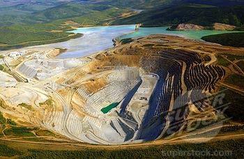
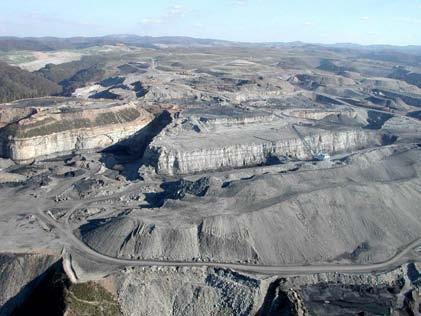


12 Alberta Geological Survey A continental tour of anthropogenic disturbances Bangor Daily News Google Earth NASA / Tom Sever Vivian Stockman, OVEC 2003
13 Remote Sensing of Forest Disturbances Change Detection Techniques Up to 2009: Discrete comparison (differencing, thresholding, classification, etc.) between each specific image (airphoto or satellite) acquisition date (two or more years) Since 2009: Trend analysis over a more full and continuous archive of satellite imagery
 on Landsat imagery Hayes and Sader")
14 Remote Sensing of Forest Disturbances Large and severe pulse disturbance (deforestation) on Landsat imagery Hayes and Sader (2001) PERS
 on Landsat imagery Cohen et al.")
15 Remote Sensing of Forest Disturbances Large and severe pulse disturbance (clear-cutting) on Landsat imagery Cohen et al. (2002) Ecosystems


16 Remote Sensing of Forest Disturbances Trends in disturbance and recovery: exploiting the full historical Landsat archive Kennedy et al. (2010) RSE

 Repeat observations every 16 days Coverage since 1972 (moreor-less)")
17 Methods: Image acquisition Trends in disturbance and recovery: exploiting the full historical Landsat archive What do you do with this stuff?? Landsat Thematic Mapper 30m spatial resolution (per pixel) 6 spectral bands (wavelength ranges) Repeat observations every 16 days Coverage since 1972 (moreor-less) Full archive freely available (since 2009)
 Hughes and Hayes (2014) Remote")
18 Methods: Pre-processing Summer clear-sky composite (aka cloud removal) Hughes and Hayes (2014) Remote Sensing

")
19 Methods: Vegetation Indices Landsat spectral bands Hughes and Hayes (2014) Remote Sensing
 (NIR Red)/(NIR + Red) (Band4 Band3)/(Band4 +")
20 Methods: Vegetation Indices Normalized Difference Vegetation Index (NDVI) (NIR Red)/(NIR + Red) (Band4 Band3)/(Band4 + Band3)


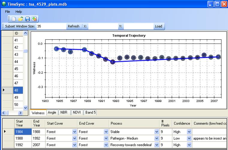
21 Methods: Trend Analysis Vegetation Index (Single Pixel Through Time) Hughes and Hayes (2014) Remote Sensing

22 Results: Spatial patterns of severity
 RSE Hughes and Hayes (2014) Remote Sensing")
23 Methods: Validation Vegetation Index Cohen et al. (2010) RSE Hughes and Hayes (2014) Remote Sensing


24 Results: Broad-scale patterns Monitoring rates of disturbance: the North American Forest Dynamics project Goward et al.; Masek et al.


25 Can we detect more subtle trends? Stress-related decline? Source: Warren Cohen


26 Results: Beyond the single pixel Disturbance Increases Patch Variance in Vegetation Index Hughes et al. in prep
27 Methods: Patch Identification Vegetation Index Patch-ified : TVR Hughes et al. in prep Hughes and Hayes (2014) Remote Sensing

28 Remote Sensing of Forest Disturbances Can we distinguish between different disturbance agents? USFS Areal Insect and Disease Survey (IDS)


29 Remote Sensing of Forest Disturbances Can we distinguish between different disturbance agents? USFS Areal Insect and Disease Survey (IDS)


30 Results: Patch Variance Agents Distinguished by Patch Variance Hughes et al. in prep

")
31 Methods: Scales of Disturbance Vegetation Index Patch-ified α = 0.20 α = 0.05 α = 0.02 Hughes et al. in prep Hughes and Hayes (2014) Remote Sensing


32 Methods: Automated Classification Training a neural network Hughes et al. in prep


33 Results: Spatial Patterns


34 Results: Validation Evaluation and Analysis Hughes et al. in prep


35 Results: Temporal Patterns % of area affected Southern Pine Beetle


36 Results: Regional Patterns Southern Pine Beetle Gypsy Moth Beech Bark Disease Hemlock Wooly Adelgid Fire TOTAL
37 Future Directions The method More truth : testing / validation Model parameter sensitivity (e.g. α in TVR) Train for anthropogenic agents (land use change) The analysis First comprehensive reports, statistics and maps of disturbance (by time, space, severity & agent) for eastern U.S. Conservation (protected areas) and management
 Impacts of disturbance on the forest carbon sink Detection of thaw-driven landscape")
38 Future Directions The applications Impacts of climate change, pollution, etc. on vegetation productivity (both increases and declines) Impacts of disturbance on the forest carbon sink Detection of thaw-driven landscape change in permafrost ecosystems (Arctic Tundra and Boreal Forest)


39 Thank You! Dan Hayes Oak Ridge National Laboratory: Meeting the challenges of the 21st century
Using Landsat time series to characterize forest insect invasions
 Using Landsat time series to characterize forest insect invasions Valerie Pasquarella Postdoctoral Fellow // University of Massachusetts Amherst Research Associate // Harvard Forest APIPP / TNC Innovations
Assessment of North American Industrial Forests Disturbances, Biomass Extraction Growth Vigor
 Assessment of North American Industrial Forests Disturbances, Biomass Extraction Growth Vigor Chengquan Huang 1, Feng Aron Zhao 1, Xin Tao 1, Ming Feng 1, Pui-Yu Ling 1, Samuel Goward 1, Karen Schleeweis
MODIS Imagery & Aerial Detection Survey
 MODIS Imagery & Aerial Detection Survey Jim Ellenwood Remote Sensing Program Manager USDA Forest Service Forest Health Technology Enterprise Team Fort Collins, CO Eric Nielsen (formerly) Remote Sensing
Forest Change Caused by Wind, Water, Ice, Fire, Insects/Disease & Harvesting
 Forest Change Caused by Wind, Water, Ice, Fire, Insects/Disease & Harvesting Why use remote sensing for mapping forest changes? Synoptic view of damage on a forest landscape or regional level. Can stop
A Landscape Perspective on Conservation for NRC Committee Addressing Sustainability Linkages
 A Landscape Perspective on Conservation for NRC Committee Addressing Sustainability Linkages Virginia Dale Oak Ridge National Laboratory Otb October 2010 Roadmap for talk Landscape perspective Gaps in
A North-American Forest Disturbance Record from Landsat Imagery
 GSFC Carbon Theme A North-American Forest Disturbance Record from Landsat Imagery Jeffrey Masek, NASA GSFC Forrest G. Hall, GSFC & UMBC Robert Wolfe, GSFC & Raytheon Warren Cohen, USFS Corvallis Eric Vermote,
Climate change, fire, insects, and disturbance interactions: adaptation challenges in the West
 http://www.yakima.net/ Climate change, fire, insects, and disturbance interactions: adaptation challenges in the West W Climate Impacts Group Don McKenzie Pacific Wildland Fire Sciences Lab U.S. Forest
Climate Change: A New Partnership for Restoration in the Rogue Basin
 Climate Change: A New Partnership for Restoration in the Rogue Basin Gwyn Myer Southern Oregon Forest Restoration Collaborative Dave Peterson USFS Pacific Northwest Research Station Ken Wearstler Rogue
Progress Report for COMBINED SATELLITE MAPPING OF SIBERIAN LANDSCAPES: NATURAL AND ANTHROPOGENIC FACTORS AFFECTING CARBON BALANCE
 Progress Report for COMBINED SATELLITE MAPPING OF SIBERIAN LANDSCAPES: NATURAL AND ANTHROPOGENIC FACTORS AFFECTING CARBON BALANCE Submitted to : Dr. Garik Gutman, LCLUC Program Manger Dr. Waleed Ablati,
Using the ForWarn System
 Highlights of Satellite-Based Forest Change Recognition and Tracking Using the ForWarn System Steven P. Norman, William W. Hargrove, Joseph P. Spruce, William M. Christie, and Sean W. Schroeder ii Table
Forest Disturbance Detection and Aboveground Biomass Modeling Using Moderate-Resolution, Time-Series Satellite Imagery
 The University of Maine DigitalCommons@UMaine Electronic Theses and Dissertations Fogler Library Summer 8-13-2018 Forest Disturbance Detection and Aboveground Biomass Modeling Using Moderate-Resolution,
Modeling endemic bark beetle populations in southwestern
 Modeling endemic bark beetle populations in southwestern ponderosa pine forests Christopher Garza 1, Barbara Bentz 2, Andrew Birt 1, Robert Coulson 1, Diana Doan-Crider 1 1 Knowledge Engineering Lab, Texas
Remote Sensing for Fire Management
 Remote Sensing for Fire Management FOR 435/535: Remote Sensing for Fire Management 5. Severity A Source of Confusion Field Measures Remote Sensing Measures FOR 435: A Source of Confusion The terms fire
MULTI-ANGULAR SATELLITE REMOTE SENSING AND FOREST INVENTORY DATA FOR CARBON STOCK AND SINK CAPACITY IN THE EASTERN UNITED STATES FOREST ECOSYSTEMS
 MULTI-ANGULAR SATELLITE REMOTE SENSING AND FOREST INVENTORY DATA FOR CARBON STOCK AND SINK CAPACITY IN THE EASTERN UNITED STATES FOREST ECOSYSTEMS X. Liu, M. Kafatos, R. B. Gomez, H. Wolf Center for Earth
USING REMOTELY SENSED DATA TO MAP FOREST AGE CLASS BY COVER TYPE IN EAST TEXAS
 USING REMOTELY SENSED DATA TO MAP FOREST AGE CLASS BY COVER TYPE IN EAST TEXAS Daniel Unger 1, I-Kuai Hung, Jeff Williams, James Kroll, Dean Coble, Jason Grogan 1 Corresponding Author: Daniel Unger (unger@sfasu.edu)
Remote Sensing Uses in Agriculture at NASS
 Remote Sensing Uses in Agriculture at NASS United States Department of Agriculture (USDA) National Agriculture Statistics Service (NASS) Research and Development Division Geospatial Information Branch
Opportunities and challenges for monitoring tropical deforestation and forest degradation in dynamic landscapes using Sentinel-2!
 Sentinel-2 For Science Workshop 20-22 May, 2014 ESA-ESRIN Frascati Opportunities and challenges for monitoring tropical deforestation and forest degradation in dynamic landscapes using Sentinel-2 Dirk
Remote Sensing (C) School Name: Student Name(s):
 School Name: Student Name(s):") School Name: Student Name(s): Remote Sensing (C) Nebraska Science Olympiad State Competition University of Nebraska-Lincoln Saturday, April 2 nd 2011 Question and Answer Sheet 100 points total Show all
School Name: Student Name(s): Remote Sensing (C) Nebraska Science Olympiad State Competition University of Nebraska-Lincoln Saturday, April 2 nd 2011 Question and Answer Sheet 100 points total Show all
Lessons learned in modeling forest responses to climate change
 Lessons learned in modeling forest responses to climate change Richard Waring College of Forestry Oregon State University Challenge Satellite-borne instruments can view current conditions, classify landscapes,
Remote Measurements of Active Fire Behavior and Post-Fire Effects
 Remote Measurements of Active Fire Behavior and Post-Fire Effects Alistair Smith (and many many others ) Remote Sensing: A very Brief Overview ~ 5 million years B.C. : Humans Begin to Understand their
Forest and land cover change detection is one of the major applications of satellite-based remote
 4.3 Trend, Nature and Rate of Forest Cover Change 4.3.1 Extent of Ikhoho Forest Cover in the year 2000 and to 2010 Forest and land cover change detection is one of the major applications of satellite-based
To provide timely, accurate, and useful statistics in service to U.S. agriculture
 NASS MISSION: To provide timely, accurate, and useful statistics in service to U.S. agriculture What does NASS do? Administer USDA s Statistical Estimating Program Conduct the 5-year Census of Agriculture
Potential Effects of Climate Change on Mixed Severity Fire Regimes of the Western U.S.
 Potential Effects of Climate Change on Mixed Severity Fire Regimes of the Western U.S. Jessica E. Halofsky David L. Peterson Pacific Wildland Fire Sciences Lab Seattle, WA Climate controls ecosystem processes
Mapping Hemlocks to Estimate Potential Canopy Gaps Following Hemlock Woolly Adelgid Infestations in the Southern Appalachian Mountains
 Mapping Hemlocks to Estimate Potential Canopy Gaps Following Hemlock Woolly Adelgid Infestations in the Southern Appalachian Mountains Tuula Kantola, Maria Tchakerian, Päivi Lyytikäinen-Saarenmaa, Robert
8/21/13. Outline. Feasibility of measuring individual trees using remote sensing. Introduction. Introduction -definition -usage -limitation
 Feasibility of measuring individual trees using remote sensing Mega Binti Abang PhD Candidate University of Tennessee Department of Forestry, Wildlife and Fisheries Room 160 Plant Biotech Building Wednesday
Ecological Restoration on the Klamath National Forest
 Ecological Restoration on the Klamath National Forest Dan Blessing Natural Resources Staff Officer Uncles Complex Klamath National Forest 08/17/2006 09:00 Objectives Policy overview What does it look like?
Understanding Juniper Forest Encroachment into Grasslands in Oklahoma and the Impacts on Primary Production, Evapotranspiration, and Climate
 Understanding Juniper Forest Encroachment into Grasslands in Oklahoma and the Impacts on Primary Production, Evapotranspiration, and Climate Jie Wang 04/24/2018 Earth observation and modeling Department
FIVE THINGS THAT MATTER IN PREDICTING DISTURBANCES & ECOSYSTEM RESPONSES
 FIVE THINGS THAT MATTER IN PREDICTING DISTURBANCES & ECOSYSTEM RESPONSES Richard Waring NASA s Carbon Cycling and Ecosystems Joint Science Workshop April 20-22th, 2015 1 st CLIMATIC VARIATION The most
Adapting to Climate Change in the Northeast: Experiences from the Field. Climate Projections for Forests: A Quick Summary
 Adapting to Climate Change in the Northeast: Experiences from the Field NE SAF Annual Meeting, Nashua, NH 26 March 2014 Small Urban Mid coast Maine Large industrial Irving Woodlands Small woodlot Allen
Adapting to Climate Change in the Northeast: Experiences from the Field
 Adapting to Climate Change in the Northeast: Experiences from the Field NE SAF Annual Meeting, Nashua, NH 26 March 2014 Small Urban Mid-coast Maine Large industrial Irving Woodlands Small woodlot Allen
Effects of the Development of the Baikal-Amur Mainline Railroad on Patterns of Boreal Forest Cover and Carbon Fluxes in Southern Siberia
 Effects of the Development of the Baikal-Amur Mainline Railroad on Patterns of Boreal Forest Cover and Carbon Fluxes in Southern Siberia Eric Kasischke (Co-Principal Investigator) Kathleen Bergen, Nancy
REMOTE SENSING NEEDS FOR STATE FORESTRY AGENCIES:
 REMOTE SENSING NEEDS FOR STATE FORESTRY AGENCIES: A VIRGINIA PERSPECTIVE John A. Scrivani Research Forester Virginia Department of Forestry Presented at the LCLUC Science Team Meeting on GOFC and Disturbance,
30 Years of Tree Canopy Cover Change in Unincorporated and Incorporated Areas of Orange County,
 30 Years of Tree Canopy Cover Change in Unincorporated and Incorporated Areas of Orange County, 1986-2016 Final Report to Orange County July 2017 Authors Dr. Shawn Landry, USF Water Institute, University
Multi-sensor imaging of tree and water cover time-series at continental to global scales
 1 Multi-sensor imaging of tree and water cover time-series at continental to global scales Joe Sexton Min Feng, Saurabh Channan, John Townshend (PI) Global Land Cover Facility Department of Geographical
The NISAR Mission. Paul Siqueira Emerging Technologies and Methods in Earth Observation for Agriculture Monitoring College Park, 2018
 The NISAR Mission Paul Siqueira Emerging Technologies and Methods in Earth Observation for Agriculture Monitoring College Park, 2018 Flyer A one-page paper-flyer is available with more information NISAR
NASA and Carbon Management
 NASA Land-Cover and Land-Use Change Science Team Meeting NASA and Carbon Management Ed Sheffner Earth Science Division April 11, 2006 1 NASA Organization Four Mission Directorates: 1. Aeronautics 2. Exploration
Afforestation/Reforestation Afforestation/Reforestation Clean Development Mechanism Projects in Uttar Pradesh State August
 Afforestation/Reforestation Clean Development Mechanism Projects in Uttar Pradesh State August 9, 2014 Suresh Chauhan TERI, New Delhi Presentation outlines 1. Guidelines for preparing Project Design Document
Future distribution and productivity of spruce-fir forests under climate change
 Future distribution and productivity of spruce-fir forests under climate change Principal Investigator: Erin Simons-Legaard, School of Forest Resources, 5755 Nutting Hall, University of Maine, Orono, ME
From Impacts to Adaptation: Canada in a Changing Climate 2007 Chapter 3 - Northern Canada
 From Impacts to Adaptation: Canada in a Changing Climate 2007 Chapter 3 - Northern Canada Chris Furgal Co-lead Author Trent University Peterborough, ON chrisfurgal@trentu.ca Photo D Vaughan 1 Context of
Impacts of Climate Change on Ecosystems
 Introduction The main objective of the UN Framework Convention on Climate Change is to stabilise greenhouse gas concentrations in the atmosphere at a level which will avoid dangerous human interference
Arctic-Boreal Vulnerability Experiment (ABoVE)
") Arctic-Boreal Vulnerability Experiment (ABoVE) Peter Griffith NASA update to UNIDATA Policy Committee May 14, 2012 Slides from Diane Wickland, NASA Terrestrial Ecology Program Manager Why ABoVE? (Motivation)
Arctic-Boreal Vulnerability Experiment (ABoVE) Peter Griffith NASA update to UNIDATA Policy Committee May 14, 2012 Slides from Diane Wickland, NASA Terrestrial Ecology Program Manager Why ABoVE? (Motivation)
Climate change, fire, and forests
 http://www.yakima.net/ Climate change, fire, and forests W Climate Impacts Group Don McKenzie Pacific Wildland Fire Sciences Lab Pacific Northwest Research Station UW Climate Impacts Group Forest Health
MOBILE BAY. Darius Hixon (Project Lead) Austin Clark Tyler Lynn Manoela Rosa. Monitoring Marsh Conditions in Coastal Alabama. Conservation Initiatives
 Austin Clark Tyler Lynn Manoela Rosa. Monitoring Marsh Conditions in Coastal Alabama. Conservation Initiatives") National Aeronautics and Space Administration MOBILE BAY MOBILE ECOLOGICAL BAY ECOLOGICAL FORECASTING FORECASTING II II Monitoring Marsh Conditions in Coastal Alabama Monitoring Using NASA Marsh Earth
National Aeronautics and Space Administration MOBILE BAY MOBILE ECOLOGICAL BAY ECOLOGICAL FORECASTING FORECASTING II II Monitoring Marsh Conditions in Coastal Alabama Monitoring Using NASA Marsh Earth
Analysis of Vegetation Mortality and Prior Landscape Condition, 2002 Biscuit Fire Complex. Kirsten Harma and Peter Morrison
 Analysis of Vegetation Mortality and Prior Landscape Condition, 2002 Biscuit Fire Complex Kirsten Harma and Peter Morrison Pacific Biodiversity Institute February 14, 2003 Introduction The Biscuit Fire
Deforestation in the Kayabi Indigenous Territory: Simulating and Predicting Land Use and Land Cover Change in the Brazilian Amazon
 Deforestation in the Kayabi Indigenous Territory: Simulating and Predicting Land Use and Land Cover Change in the Brazilian Amazon Hugo de Alba 1, Joana Barros 2 GEDS, Birkbeck, University of London, Malet
Remotely sensed change product considerations
 Remotely sensed change product considerations M. Wulder, J. White CFS, N. Coops, T. Hermosilla, D. Bolton UBC R Kennedy, W. Cohen OSU T. Schroeder - USGS Outline Nature of change from time series Hierarchy
Science Mission Directorate Carbon Cycle & Ecosystems Roadmap NACP
 Science Mission Directorate Carbon Cycle & Ecosystems Roadmap NACP Bill Emanuel Program Scientist, Terrestrial Ecology Carbon Cycle & Ecosystems Focus Area Carbon Cycle & Ecosystems Focus Area Program
Monitoring and Climate Change. Dave Cleland
 Monitoring and Climate Change Dave Cleland Presentation Outline National perspective on status and needs of climate change monitoring Brief review of emerging monitoring programs Short term approach to
Monitoring Natural Sal Forest Cover in Modhupur, Bangladesh using Temporal Landsat Imagery during
 Monitoring Natural Sal Forest Cover in Modhupur, Bangladesh using Temporal Landsat Imagery during 1972 2015 Hasan Muhammad Abdullah *, M. Golam Mahboob, Md.Mezanur Rahman, Tofayel Ahmed * Assistant Professor,
VERMONT. Forest Health Programs in the Northeast. Forest Resource Summary. Forest Land Ownership
 2008 Foresthighlights Health VERMONT Forest Resource Summary Vermont s forests, which encompass 4.6 million acres, offer valuable ecological, economic, and social benefits. Healthy forests are resilient
FOREST CHANGE DETECTION AND MAPPING IN GATINEAU PARK, QUÉBEC, 1987 TO 2010 USING LANDSAT IMAGERY
 FOREST CHANGE DETECTION AND MAPPING IN GATINEAU PARK, QUÉBEC, 1987 TO 2010 USING LANDSAT IMAGERY Christopher J. Czerwinski 1, Doug J. King 2, Scott W. Mitchell 3 Carleton University, Department of Geography
Managing Alberta s Forests: Lessons from Research Basins
 Managing Alberta s Forests: Lessons from Research Basins Marmot Creek Research Basin 50 th Anniversary Workshop March 21-22, 2013 John Diiwu Forest Management Branch Alberta Environment and Sustainable
Forest monitoring information needs in Canada
 Forest monitoring information needs in Canada Mike Wulder and Joanne White Canadian Forest Service Pacific Forestry Centre, Victoria GEOBIA 2008 Mandate of the Canadian Forest Service (CFS) National science-based
Panel Discussion. Sergey Bartalev: Russia Tuomas Hame: Finland Eva Konkoly-Gyuro: Hungary Anu Reinart: Estonia Premysl Stych: Czech Republic
 Panel Discussion Sergey Bartalev: Russia Tuomas Hame: Finland Eva Konkoly-Gyuro: Hungary Anu Reinart: Estonia Premysl Stych: Czech Republic Panel Discussion Notes Russia Emphasis on Applications Forest/Agric/Wetland
United States Forest Disturbance Trends Observed Using Landsat Time Series
 Ecosystems (2013) 16: 1087 1104 DOI: 10.1007/s10021-013-9669-9 Ó 2013 Springer Science+Business Media New York (Outside the USA) United States Forest Disturbance Trends Observed Using Landsat Time Series
Next decade research needs for managing the climate/vegetation nexus in Australia
 Next decade research needs for managing the climate/vegetation nexus in Australia An NCAS/AGO View Vegetation Dynamics and Climate Change 14 August 2007 Expanded Topic To help position Australian land
Improvements in Landsat Pathfinder Methods for Monitoring Tropical Deforestation and Their Extension to Extra-tropical Areas
 Improvements in Landsat Pathfinder Methods for Monitoring Tropical Deforestation and Their Extension to Extra-tropical Areas PI: John R. G. Townshend Department of Geography (and Institute for Advanced
Presentation plan General aims, approaches and tools Our approaches to zoning and classification of vegetation at hierarchical levels General backgrou
 Presentation plan General aims, approaches and tools Our approaches to zoning and classification of vegetation at hierarchical levels General background on status of ecological regionalization and mapping
Mangrove deforestation analysis in Northwestern Madagascar Stage 1 - Analysis of historical deforestation
 Mangrove deforestation analysis in Northwestern Madagascar Stage 1 - Analysis of historical deforestation Frédérique Montfort, Clovis Grinand, Marie Nourtier March 2018 1. Context and study area : The
Fire Ecology and Conservation Mary Jane Epps
 Fire Ecology and Conservation Mary Jane Epps 1 84% of important global conservation areas are considered at risk because of human-caused changes to the natural fire regime. (TNC) 1 Fire History Pre-1900
COMPARATIVE STUDY OF NDVI AND SAVI VEGETATION INDICES IN ANANTAPUR DISTRICT SEMI-ARID AREAS
 International Journal of Civil Engineering and Technology (IJCIET) Volume 8, Issue 4, April 2017, pp. 559 566 Article ID: IJCIET_08_04_063 Available online at http://www.iaeme.com/ijciet/issues.asp?jtype=ijciet&vtype=8&itype=4
Anne Hairston-Strang MD DNR Forest Service September 7, 2017
 Anne Hairston-Strang MD DNR Forest Service September 7, 2017 Improving Forest-related BMPs Riparian Forest Buffers Consider drainage flow context and Farm Plan Address concentrated flows with companion
Forest change detection in boreal regions using
 Forest change detection in boreal regions using MODIS data time series Peter Potapov, Matthew C. Hansen Geographic Information Science Center of Excellence, South Dakota State University Data from the
DETERMINING LAND USE CHANGE WITHIN THE DOG RIVER WATERSHED USING LANDSAT IMAGERY
 DETERMINING LAND USE CHANGE WITHIN THE DOG RIVER WATERSHED USING LANDSAT IMAGERY Joshua M. Pritchard, Department of Earth Sciences, University of South Alabama, Mobile, AL 36688-0002. E-mail: jmp601@gmail.com.
Temporal Relationship Between Landsat 8 Spectral Reflectance and Transparency in Grand Lake O' the Cherokee
 Temporal Relationship Between Landsat 8 Spectral Reflectance and Transparency in Grand Lake O' the Cherokee 37 TH Annual Oklahoma Governor s Water Conference October 11 th 12 th, 2016 Norman, Oklahoma
The Future of our Boreal Forests. Mike Flannigan and Tim Lynham Canadian Forest Service
 The Future of our Boreal Forests Mike Flannigan and Tim Lynham Canadian Forest Service Outline Recent climate - Climate change Impacts of climate change on forests primarily disturbances Options Summary
The Role of Biotic Disturbance Agents in Carbon-Climate Connections
 The Role of Biotic Disturbance Agents in Carbon-Climate Connections Jeffrey Hicke Department of Geography University of Idaho Emphasis: Forests, bark beetles, western North America Credit: Leslie Manning/Canadian
Climate Change. Introduction
 Climate Change This environmental assessment incorporates by reference (as per 40 CFR 1502.21) the Climate Change specialists report and other technical documentation used to support the analysis and conclusions
Objectives: New Science:
 Edge effects enhance carbon uptake and its vulnerability to climate change in temperate broadleaf forests Reinmann, A.B. and Hutyra, L.R., PNAS 114 (2017) 107-112 DOI: 10.1073/pnas.1612369114 Objectives:
Agricultural monitoring of Russia using Remote Sensing: an overview
 Russian Academy of Sciences Space Research Institute Agricultural monitoring of Russia using Remote Sensing: an overview Savin I., Bartalev S., Loupian E. Some features of R&D at IKI Focus is on national
Forest Health Protection funding for tribal lands
 Forest Health Protection funding for tribal lands Tom W. Coleman Entomologist USDA FS, Forest Health Protection San Bernardino, CA Forest Service & BIA Forest Health Projects The Cooperative Forestry Assistance
2. Climate change and forests
 7 2. Climate change and forests CLIMATE CHANGE PROCESSES AND PROJECTIONS The Earth s climate changes continually under the influence of a range of natural forces. Currently, however, observed significant
WESTERN WILDLANDS ENVIRONMENTAL THREATS ASSESSMENT CENTER. Nancy Grulke, WWETAC John B. Kim, Pacific Northwest Research Station & WWETAC
 WESTERN WILDLANDS ENVIRONMENTAL THREATS ASSESSMENT CENTER Nancy Grulke, WWETAC John B. Kim, Pacific Northwest Research Station & WWETAC WWETAC DIRECTOR: FUNDING: Nancy Grulke US Forest Service DURATION:
Navigating Climate Change: the Role of the Terrestrial Biosphere
 Navigating Climate Change: the Role of the Terrestrial Biosphere Scott Goetz Northern Arizona University g2p2pop workshop Flagstaff, AZ Sept 2018 Trends in Global Air Temperature Patterns 1950-2017 NASA
Identifying and and Understanding Carbon Cycle Implications of of North American Natural and and Anthropogenic Disturbances:
 Identifying and and Understanding Carbon Cycle Implications of of North American Natural and and Anthropogenic Disturbances: 1982-2005 Progress Progress Report Report NRA-04-OES-01 NRA-04-OES-01 Christopher
Carbon Cycle & Ecosystems. Diane E. Wickland, Focus Area Lead April 12, 2006
 Carbon Cycle & Ecosystems Diane E. Wickland, Focus Area Lead April 12, 2006 Carbon Cycle & Ecosystems Program Elements & Managers Ocean Biology and Biogeochemistry Paula Bontempi Land Cover and Land Use
Performance anomalies are a relative measure of ecosystem services
 Performance anomalies are a relative measure of ecosystem services Bruce K. Wylie 1, J. Rover 2, and E. Fosnight 1 1 ASRC Research and Technology Solutions, contractor to the USGS at the EROS Center. Work
Climate Change and the Arctic Ecosystem
 Climate Change and the Arctic Ecosystem Key Concepts: Greenhouse Gas WHAT YOU WILL LEARN Biome Carbon sink Global warming Greenhouse effect Permafrost 1. You will analyze how global warming is impacting
Remote Sensing for Monitoring USA Crop Production: What is the State of the Technology
 Remote Sensing for Monitoring USA Crop Production: What is the State of the Technology Monitoring Food Security Threats from Space - A CELC Seminar Centurion, SA 21 April 2016 David M. Johnson Geographer
2.5. Accuracy Testing
 Remote Sens. 2016, 8, 542 8 of 19 to quantify due to difficulties in measuring tree height in the field. We assume that each CHM has an uncertainty of less than 1 m, and changes in canopy height between
NORTH AMERICAN CARBON PROGRAM. Continental carbon budgets, dynamics, processes, and management. Program Overview and Progress
 NORTH AMERICAN CARBON PROGRAM Continental carbon budgets, dynamics, processes, and management. Program Overview and Progress NACP Questions 1. What is the carbon balance of North America and adjacent oceans?
Environmental Hotspot Alert
 UNEP Global Environmental Alert Service (GEAS) Taking the pulse of the planet: connecting science with policy Website: www.unep.org/geas E-mail: geas@unep.org To view online and download Alerts, go to
Everett A. Hinkley National Remote Sensing Program Manager
 USDA Forest Service Wildfire Support Programs Update GOFC-Fire IT Meeting October 2011 Everett A. Hinkley National Remote Sensing Program Manager USDA Forest Service / Geospatial Management Office Brad
Remote Sensing of Environment
 Remote Sensing of Environment 113 (2009) 1430 1442 Contents lists available at ScienceDirect Remote Sensing of Environment journal homepage: www.elsevier.com/locate/rse Dynamics of national forests assessed
A Remote Sensing Based System for Monitoring Reclamation in Well and Mine Sites
 A Remote Sensing Based System for Monitoring Reclamation in Well and Mine Sites Nadia Rochdi (1), J. Zhang (1), K. Staenz (1), X. Yang (1), B. James (1), D. Rolfson (1), S. Patterson (2), and B. Purdy
Remote Sensing (C) Team Name: Student Name(s):
 Team Name: Student Name(s):") Team Name: Student Name(s): Remote Sensing (C) Nebraska Science Olympiad Regional Competition Henry Doorly Zoo Saturday, February 27 th 2010 96 points total Please answer all questions with complete sentences
Team Name: Student Name(s): Remote Sensing (C) Nebraska Science Olympiad Regional Competition Henry Doorly Zoo Saturday, February 27 th 2010 96 points total Please answer all questions with complete sentences
Narration: This presentation is divided into four sections. It looks first at climate change and adaptation for natural forests, and then for
 1 Narration: This presentation is an overview of the impacts of climate change on forest ecosystems. You will learn about the impacts of climate change on natural forests and tree plantations. You will
SandYare the strata-weighted mean, and standard
 A LANDSAT STAND BASAL AREA CLASSIFICATION SUITABLE FOR AUTOMATING STRATIFICATION OF FOREST INTO STATISTICALLY EFFICIENT STRATA Emily B. Schultz a, Thomas G. Matney a, David L. Evans a, and Ikuko Fujisaki
Standard Methods for Estimating Greenhouse Gas Emissions from Forests and Peatlands in Indonesia
 Standard Methods for Estimating Greenhouse Gas Emissions from Forests and Peatlands in Indonesia (Version 2) Chapter 5: Standard Method Forest Cover Change MINISTRY OF ENVIRONMENT AND FORESTRY RESEARCH,
Forest and Land Cover Monitoring by Remote Sensing Data Analysis
 Low Carbon Asia Research Network (LoCARNet) 3rd Annual Meeting Bogor, Indonesia November 24 26, 2014 Forest and Land Cover Monitoring by Remote Sensing Data Analysis Muhammad Ardiansyah Center for Climate
ASSESSING THE DIRECTION OF THE FOREST RESOURCE
 ASSESSING THE DIRECTION OF THE FOREST RESOURCE C U R T W I L S O N - R E G I O N A L F O R E S T R Y L E A D E R N O R T H E A S T R E G I O N - G R E E N B A Y, W D N R J U N E 2 0 1 2 QUESTIONS FOR TODAY
Reflections on user needs from the research community for monitoring of terrestrial ecosystems
 Reflections on user needs from the research community for monitoring of terrestrial ecosystems Terry V. Callaghan and Friends Royal Swedish Academy of Sciences Abisko Scientific Research Station Why do
AIMS pilot project. Monitoring the rehabilitation of degraded landscapes from Food Assistance for Assets programmes with satellite imagery
 Fighting Hunger Worldwide AIMS pilot project Monitoring the rehabilitation of degraded landscapes from Food Assistance for Assets programmes with satellite imagery September 2017 BEFORE road construction
AN ABSTRACT OF THE DISSERTATION OF
 AN ABSTRACT OF THE DISSERTATION OF Daniel J. Hayes for the degree of Doctor of Philosophy in Forest Science presented on November 17, 2006. Title: Remote Sensing for Monitoring Regional Carbon Dynamics
Synergies, feedbacks and tipping points: mountain pine beetle s rapid range expansion threatens invasion of North American boreal pine forests
 Synergies, feedbacks and tipping points: mountain pine beetle s rapid range expansion threatens invasion of North American boreal pine forests Allan L. Carroll The University of British Columbia Department
Analysis of forest disturbance dynamics in the Tatra Mountains using Landsat time series from 1986 to 2015
 Analysis of forest disturbance dynamics in the Tatra Mountains using Landsat time series from 1986 to 2015 Bachelorarbeit Humboldt-Universität zu Berlin Geographisches Institut eingereicht von: Katja Kowalski
Estimating the spatial pattern and extent of hemlock mortality after HWA infestation in the Linville River Gorge via aerial imagery
 Estimating the spatial pattern and extent of hemlock mortality after HWA infestation in the Linville River Gorge via aerial imagery Sheryl Strauch 1, Tuula Kantola 2, Maria Tchakerian 1, Robert Coulson
Science affects the way we think together. MONITORING FORESTS FROM SPACE: QUANTIFYING FOREST CHANGE BY USING SATELLITE DATA
 PNW Pacific Northwest Research Station I n s i d e An Index of Forest Change... 2 A Breakthrough in Mapping... 3 Scaling Up... 4 Supplementing Forest Inventories... 5 F I N D I N G S issue eighty nine
MARYLAND. Forest Resource Summary. Forest Health Programs
 2014 Foresthighlights Health MARYLAND Forest Resource Summary Maryland occupies a land area of 6,264,876 acres. Forest land comprises 2,709,062 acres, of which 72 percent is privately owned. Healthy, productive
Invasive Species Mapping in Hawaiian Rainforests Using Multi-Temporal Hyperion Spaceborne Imaging Spectroscopy
 Application Invasive Species Mapping in Hawaiian Rainforests Using Multi-Temporal Hyperion Spaceborne Imaging Spectroscopy Ben Somers Gregory P Asner invasive species threat? invasive species threat? Molnar