RECOGNIZED AQUATIC AND WETLAND RESOURCES
|
|
|
- Regina Walters
- 5 years ago
- Views:
Transcription
1 RECOGNIZED AQUATIC AND WETLAND RESOURCES IN WESTERN PLACER COUNTY, CALIFORNIA Prepared for: Placer County Planning Department 'B' Avenue Auburn, California Prepared by: 110 Maple Street, Suite 100, Auburn, California (530) December 2003
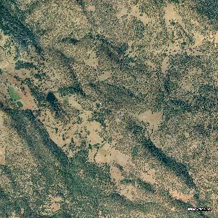
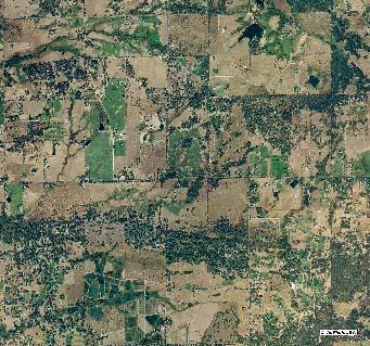
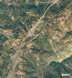
2 TABLE OF CONTENTS Introduction...1 Goals and Objectives...1 Wetland Classification...1 Study Area...2 Western Placer County Environment...2 Topography...2 Rainfall...7 Geology and Soils...7 Land Use...7 Methods...8 Available GIS Data...8 Mapping Criteria...8 Aerial Mapping...9 Field Documentation...10 Map Metadata...10 Placer County Water Management...10 Western Placer County Wetlands and Open Water Habitats...10 Riverine Systems...13 Lacustrine Systems...13 Palustrine Systems...14 Complexes...14 References...14 FIGURES Figure 1. Study Area with USGS Basemap...3 Figure 2. Recognized Aquatic and Wetland Resources in Western Placer County with USGS Basemap...4 Figure 3. Recognized Aquatic and Wetland Resources in Western Placer County with Aerial Photo Basemap...5 Figure 4. Recognized Aquatic and Wetland Resources in Western Placer County with DEM Basemap...6 Figure 5. Typical Wetland Types in Western Placer County...11 Figure 6. Typical Wetland Types in Western Placer County...12 APPENDICES Appendix A. Recognized Aquatic and Wetland Resources in Western Placer County ii
3 Recognized Aquatic and Wetland Resources in Western Placer County INTRODUCTION Over the past 150 years, many of the natural communities in western Placer County have been converted to urban, rural, suburban, industrial, and agricultural uses. The County Planning Department, through the Placer Legacy program, is currently mapping and documenting what remains and what might be preserved. Vernal pool and riparian resources have been documented and mapped to some extent. Likewise, a considerable amount is known about the rivers, creeks, and streams. But, aside from the major reservoirs, little is known about the County s open water ponds. In addition, very little is known about the location and extent of non-vernal pool wetlands within western Placer County. Without this knowledge, planning for future development cannot accurately take into account the impact that development will have on wetlands in the area. To help fill this data gap, the County, with the help of an EPA grant, has funded a work program to map these under documented resources. Before beginning the work, North Fork Associates prepared a Quality Assurance Project Plan (NFA, February 28, 2003) that was submitted to the County and the EPA. In general, we followed the methods described in Group B: Data Generation and Acquisition. In the early stages, North Fork Associates biologists provided the County with a detailed description of the habitat types and habitat attributes that would be mapped during the project. Once the photointerpretation started, however, it became apparent that the level of effort needed to document the detailed attributes originally described far exceeded the constraints of both time allocation and budget. Consequently, the level of mapping detail was reduced to a scope that would fit within the time and budget framework of the EPA grant. This level of detail fits well with the existing Placer Legacy program and is described in the following sections. GOALS AND OBJECTIVES The primary goal of this study was to determine the location and extent of wetlands and open water habitats in western Placer County (Figure 1). To meet that goal, we mapped these features on aerial photographs, using USGS maps and aerial and ground surveys to check those results. The process is described in the Methods section. The criteria used for mapping are also discussed in the Methods section. All data were compiled in ArcView GIS for use by the County and other interested parties. WETLAND CLASSIFICATION No simple universal system is available for categorizing wetland types. To complicate matters further, not all wetlands in California are wet for 12 months. Most people recognize a marsh as a wetland because this type usually has standing water all year. But, vernal pools, which are special wetlands occurring in shallow depressions, are inundated during the winter and dry out by late spring or early summer. Seeps and other seasonal wetland may not exhibit surface inundation, but the soil is often saturated long enough to develop wetland indicators. 1
4 In a 1979 publication, Cowardin et al. developed a hierarchical system of classifying wetlands. The uppermost categories are marine, estuarine, riverine, lacustrine, and palustrine systems. Placer County does not have the first two systems, but it does have various types of the last three. Cowardin s system went on to describe lower levels of the hierarchy, but these levels are of little use when mapping large areas at relatively small scales. All wetland and open water habitats in western Placer County were mapped as riverine, lacustrine, or palustrine. Riverine and lacustrine systems are open water habitats. That is, they are either too deep or have too much flowing water to support vegetation. Palustrine systems are wet, vegetated habitats. Riverine and lacustrine systems often have a palustrine component on the margins that is not strictly part of the riverine or lacustrine habitat. I some instances, features were so large and diverse that they could not be separated into components, and these were mapped as complexes. Figure 2 shows a small-scale map of the various wetland types overlaid on the USGS quadrangles. Figure 3 is a similar map overlaid on the mosaic of fall 2003 aerial photos. Also included on both figures are the vernal pool areas mapped in the early 1990s. STUDY AREA The study area, western Placer County, is defined roughly by Highway 49 and the American River on the east, Sacramento County to the south, Sutter County to the west, and Yuba County and Nevada County (roughly the Bear River) to the north. Figure 1 shows the study area on the USGS quadrangles for the region. The study area covers approximately 428 square miles and encompasses the rapidly growing cities of Roseville, Rocklin, and Lincoln. Western Placer County can be divided into three geographic provinces. These areas are the valley floor, the lower foothills, and the upper foothills. The valley floor is generally considered the area west of State Route 65 and ranges in elevation from 40 to 150 feet. It is relatively flat and devoted to urbanization in the south and agricultural crops, primarily small grains such as rice and wheat, in other areas. There is a conspicuous lack of native woody vegetation in this area, other than along riparian corridors such as Auburn Ravine. Somewhere east of Highway 65, the landscape changes from the flat valley to low undulating hills supporting grassland and oak woodland. It ranges in elevation from 150 to about 600 feet. This area was historically cattle country, and large portions of it are still devoted to that activity. However, much of it has been subdivided into smaller parcels ranging from one to twenty acres. The smaller parcels are often used for raising horses, orchards, and other activities. The eastern portion of the study area from Loomis to Auburn north consists of the steeper Sierra Nevada foothills covered with various types of oak woodland. It ranges in elevation from 600 to 1,200 feet. This part of the county, too, has been subdivided into smaller parcels, although orchards and horse pastures are still common from State Highway 193 north. WESTERN PLACER COUNTY ENVIRONMENT Topography Topography in western Placer County is varied (Figure 4). The western portion is nearly flat or gently sloping. The central portion consists of rolling foothills with several higher ridges running east to west. The higher portions in the northeast corner are more highly dissected 2
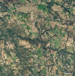
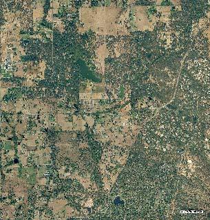
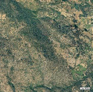
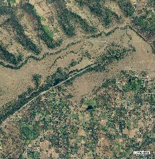
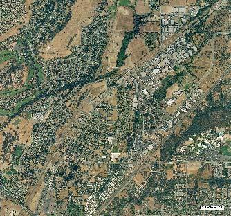
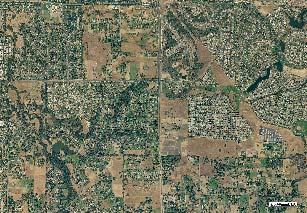
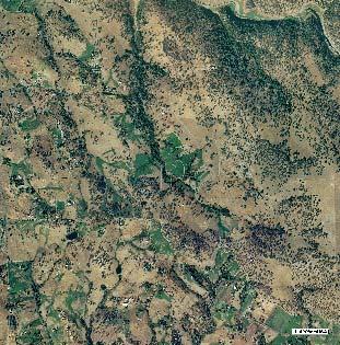
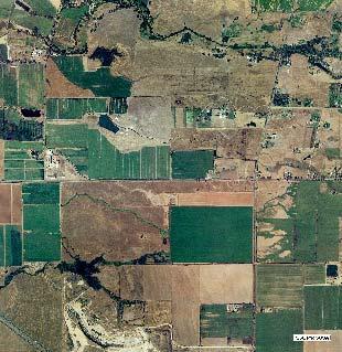
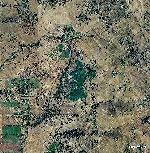
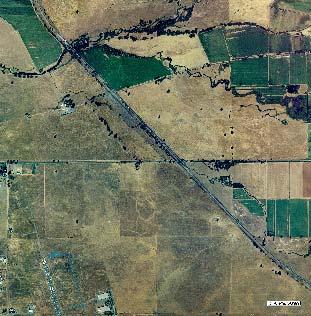
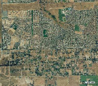
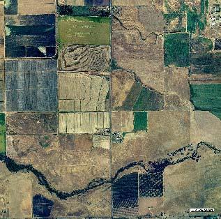
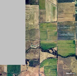
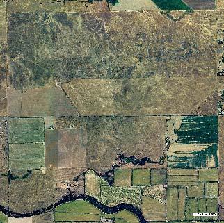
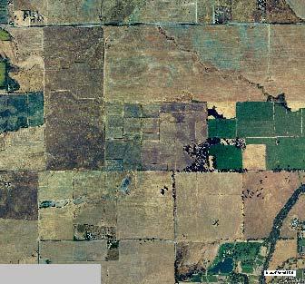
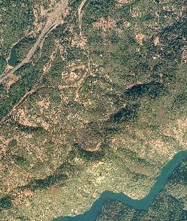
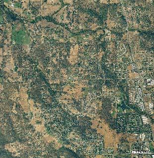
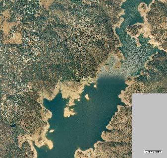
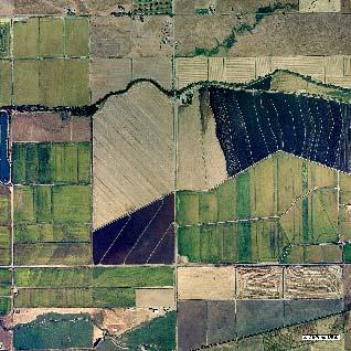
5 Wetland Types Riverine Palustrine Lacustrine Complex Vernal Pool Complex 0 3 Miles W N Photos taken Fall of 2002 by AirPhoto USA S E Figure 3 Recognized Aquatic and Wetland Resources in Western Placer County with Aerial Photo Basemap


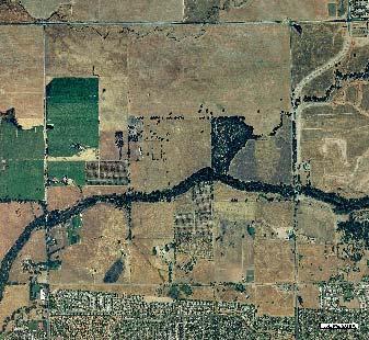
6 Wetland Types Riverine Palustrine Lacustrine Complex Vernal Pool Complex 0 3 Miles N W E S Figure 2 Recognized Aquatic and Wetland Resources in Western Placer County with USGS Basemap

7 W N S E 0 4 Miles Figure 1 Study Area with USGS Basemap

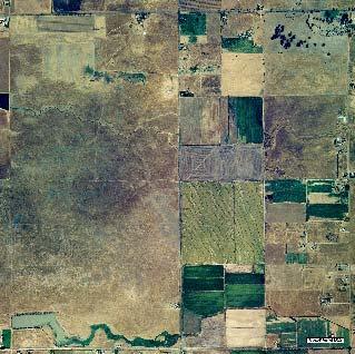
8 Wetland Types Riverine Palustrine Lacustrine Complex Vernal Pool Complex 0 3 Miles N W E S Figure 4 Recognized Aquatic and Wetland Resources in Western Placer County with DEM Basemap
9 with steeper slopes and higher peaks and valleys. The primary effect of topography is the production of higher rainfall amounts and, therefore, greater and stronger runoff. Rainfall The rainy season in the western county occurs between November and May, and the majority falls between December and March. Rainfall amounts are largely the result of topography and increase rapidly from the valley floor to the higher foothills. Average precipitation at Roseville is 18 inches and at Lincoln it is 20 inches. Rocklin receives over 20 inches and Auburn gets over 35 inches. Geology and Soils The area immediately around Auburn consists of Jurassic and Triassic metavolcanic rocks. The remainder of the upper foothills is composed of Mesozoic granitic rocks. Pliocene nonmarine sediments occur between the granitic rocks to the east and Highway 65 between Roseville and Lincoln. These sediments form the Mehrten Formation, which consists of a variety of cemented material, and is well known for supporting some of the best vernal pools along the east side of the Central Valley. Eocene deposits of he Ione Formation form small pockets associated with the Mehrten. West of highway 65, is a large extent of Pliocene and Pleistocene nonmarine sediments. These tend to form coarse, well drained soils. Further to the west, more recent alluvial fan deposits form coarse to fine grained soils. Soils in the upper and lower foothills of western Placer County include Auburn, Sobrante, Andregg, Caperton, Sierra, Exchequer, and Inks. The upper foothill soils are shallow to moderately deep and are typically well drained. As a result, much of the rainfall in this region finds its way into streams either through direct runoff or groundwater discharges. The Exchequer-Inks soils occur over shallow volcanic rock. Inks soils are formed from consolidated or cemented sediments derived from volcanic rock. This is one of the primary Mehrten Formation soils. Valley soils include San Joaquin, Cometa, Fiddyment, Kasberg, Ramona, Kilga, Redding, and Corning Series. Several of these are Alfisols and have dense, subsurface clay layers that impede water percolation. Wetlands are often found on these soils because they tend to hold water, especially in depressions. Land Use Western Placer County has a variety of land uses including urban centers and agriculture. Most of the county is in private hands. Roseville, Rocklin, and Lincoln are rapidly growing urban communities in the southern part of the county. Loomis, Penryn, and Auburn still retain some of the rural atmosphere that once was more common in the area. Outside the city limits of these communities, residential lots are larger and the population density is lower. The far western part of the county is devoted to crop production. Rice is a common crop on the heavy clay soils of the northwest. The thinner soils of the valley and lower foothills are used for livestock grazing. Orchards are still relatively common from Newcastle north and east to Auburn. This part of the county also has a few vineyards, and small strawberry patches are common on open ground throughout the foothills. 7
10 METHODS Available GIS Data The Placer Legacy program has developed a number of GIS data layers for various parts of the county. These are available for viewing at These data sets can be made available in GIS format to approved users. Mapping Criteria As mapping progressed, it became clear that guidelines were needed to help determine what was to be mapped. Western Placer County supports a large and extensive system of wetland caused by leaking water delivery canals, irrigation runoff, irrigated pastures, and others. For the most part, the wetland types were excluded from this analysis. Natural and manmade habitats: Rivers and streams in western Placer County are natural features, although many have been substantially affected by man s activities. Because so few wetlands in western Placer County are natural, decisions had to be made about what to include. Wetlands associated with impoundments were usually mapped, especially if they were large and connected to other habitats. Very small or isolated wetlands and open water habitats were usually not mapped. These usually occur on small parcels (one to five acres, or so) and are not amenable to long-term conservation by public agencies. For the most part, wet areas created by leaky canals and pipelines, or from irrigation runoff, were not mapped, although some might be within the Corps 404 regulatory authority. Habitat value: Habitat value played a large part in determining what was mapped. Areas that that had species, habitat, or structural diversity were typically mapped, even though they were the result of human activities. Markham Ravine in Lincoln and portions of lower Auburn Ravine are good examples. These area support several habitat types and provide structural diversity that would not otherwise exist in the region. Mapped areas that support wetlands, open water, and riparian vegetation were particularly highly rated. We also looked at wetlands and open water habitats to see whether they were contiguous with other similar habitats. Small isolated ponds, for example, were often not mapped. Ponds in or near streams usually were. Some county streams have stretches with natural channels and good habitat and stretches where the channel has been realigned and channelized. In these cases, the good stretches were mapped and the channelized stretches may not have been (we were not always consistent with this guideline). Mixed categories: Areas of high habitat value are often also areas with more than one category of wetlands and open water. Persons using the data set should realize that polygons mapped as riverine or lacustrine usually also include palustrine habitats on the edges of those systems. Ponds, for example, usually have a substantial fringe of freshwater marsh, a palustrine system. Where the area mapped was large and complex it was mapped as a miscellaneous category. The best of these mixed habitats includes a riparian canopy of trees and shrubs. Temporal changes: The extent of the various systems changes annually in some mapped polygons. For example, a pond might appear as open water (lacustrine) in February and as cattail marsh (palustrine) in September. Likewise, some streams may be mostly open water, flowing water (riverine) during the winter but have a large wetland fringe (palustrine) during 8
11 the summer and fall. These annual shifts provide a variety of wildlife habitats throughout the year. A second temporal change affects how the maps are viewed. Wetlands obvious at one season may not be so obvious in another, and this can affect what the view sees. Wetlands mapped on summer aerials may not be readily identified on winter aerials. Also, some wetlands obvious in late spring or early summer may not be apparent on fall aerials. Perennial, intermittent, and ephemeral systems: Perennial streams were always mapped. Intermittent streams were usually mapped, except where they have been converted to ditches for considerable distances. This conversion is most apparent in the valley portion of the county west of Highway 65. Ephemeral streams were rarely mapped. These are areas that may be within the Section 404 authority of the Corps of Engineers, but are too narrow and too extensive to map. Scale and edge matching: Some of the aerial sets had very high resolution, allowing us to use very large scales while looking for mappable features. Many natural wetlands, mostly seeps and springs, are small or obscured by tree and shrub cover. For the most part these were not mapped. On the other hand, marshes and wetland complexes created in part by man tend to be large and in open areas, and these were readily mapped. Consequently, most of the mapped wetland features are areas affected by human activities. The various aerials used for this study did not match perfectly. As a result, the viewer may see some map polygons offset slightly from what the aerial shows. This probably occurred because the polygon was mapped on another aerial that was not matched exactly. Other data sets show similar offsets, again, probably the result of poorly matched aerials. USGS maps: We attempted to map all features shown as blueline streams or bodies of open water shown on USGS quadrangle maps. In some cases, particularly rapidly growing areas such as Rocklin and Roseville, what is shown on the maps and what is evident on recent aerial photographs were vastly different. Regulatory issues: The Corps of Engineers regulates activities in waters of the United States as prescribed by the federal Clean Water Act. The definition of waters of the United States includes wetlands, which also are sometimes described as special aquatic sites. Except for isolated wetlands, the Corps would probably regulate all mapped areas. The Regional Water Quality Control Board regulates all Corps areas under Section 401 of the Clean Water Act. It now regulates isolated wetlands under the state Porter-Cologne Water Quality Act. The Department of Fish and Game regulates perennial and intermittent streams, and some ponds, but may not claim jurisdiction over ephemeral drainages with no riparian cover. This map is not intended to show all potentially regulated areas. Few if any ephemeral drainages have been mapped. Many of the unmapped stock ponds may also be regulated by one or more of the agencies. Ditches, and wetlands emanating from leaky canals and pipelines may also be regulated, but these were rarely mapped. Aerial Mapping A series of aerial photographs were used for this project. Dates ranged from March 1999 to January These also covered a period of months. Summer photographs were particularly useful in some areas because wetland areas are usually obvious during the dry parts of the year. 9
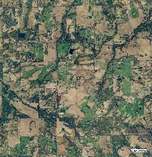
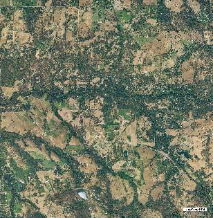
12 The final map was prepared on the fall 2003 series of photographs in order to match this data set with existing data (see Appendix A) Field Documentation Field identification of the mapped features took place throughout the study period, with the emphasis occurring after the draft map was complete. Aerial reconnaissance was conducted on one occasion to cover as much ground as possible as well as view landscapes not available to see from the ground. Map Metadata All map data is in California State Plane, Zone 3, NAD 27. PLACER COUNTY WATER MANAGEMENT The first water distribution system in the county was developed in the early 1850s to provide water for mining operations. By the 1890s, agriculture began to replace mining as the dominant economic force in the county, and the canal system began to supply more water to orchards, farms, and ranches in western Placer County. A substantial orchard and fruit packing industry arose in the foothills between Folsom and Lincoln in the early part of the 20 th century. Remnants of this industry are still evident, but it is nowhere near as extensive as it was between 1935 and Three agencies store or distribute water in Placer County: Placer County Water Agency, Nevada Irrigation District, and Pacific Gas & Electric. Placer County Water Agency has 165 miles of canals in the County, and the majority of these are in the western Placer County study area. The Nevada Irrigation District has 425 miles of canals and 300 miles of pipelines in four counties. These agencies supply water for various uses, but does not always know how the water is used. Once it is delivered, the buyer may use it for irrigation, stock ponds, or other uses. Pacific Gas & Electric accumulates and stores water, but much of its water is purchased by the other water agencies for dispersal. Most of the lacustrine habitats in western Placer County are the result of water deliveries to stock ponds. In addition, many of the wetlands occur because of leaky canals and pipelines, and from agricultural runoff. WESTERN PLACER COUNTY WETLANDS AND OPEN WATER HABITATS The map and GIS files included with this report show the locations of substantial riverine, lacustrine, and palustrine systems in western Placer County. Most of the riverine features are natural features, whereas most of the lacustrine features are the result of mans activities. Palustrine features in the western County are a mix of man-induced and natural wetlands. The Corps of Engineers often refers to areas that have flowing or standing water and lack vegetation as other waters, and these are mapped as riverine and lacustrine respectively. Wetlands, on the other hand, are waters of the United States that are vegetated, and these are mapped as palustrine. Figure 5 and Figure 6 show various wetland types that have been mapped. 10


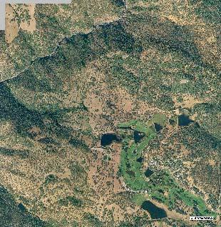
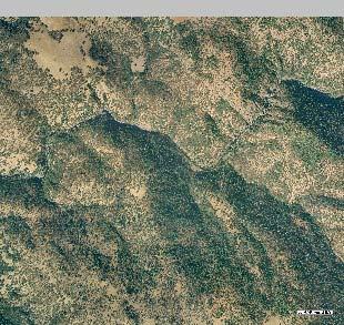
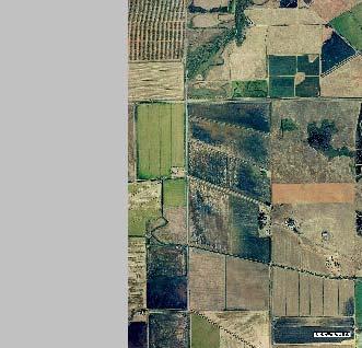
13 Typical vernal pool complex adjacent to cultivation. Irrigation-influenced palustrine area in foothills. Riverine corridor (Coon Creek) Photos taken July 4, 2003 Figure 5 Typical Wetland Types in Western Placer County
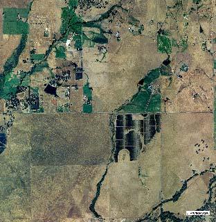
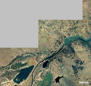
14 Riverine Systems Riverine systems are linear open water habitats characterized by the presence of flowing water. Examples are rivers, streams, creeks, and other drainages. Streams may be further classified by the duration of running water. Perennial streams have flowing water all year. The American River and the Bear River are natural perennial streams. Intermittent streams flow during and for some time after the rainy season, but they are usually dry before the beginning of the next rainy season. Intermittent streams often have a large groundwater component. Many western Placer County streams were intermittent, and a few may have been naturally perennial. Ephemeral streams flow only and shortly after periods of rainfall, and they do not have a strong groundwater component. Cowardin et al. did not discuss ephemeral streams, but many of these are regulated by the Corps of Engineers. The American River on the southern county line and the Bear River on the northern county line are the primary riverine systems in the western part of the county. Both rivers have been dammed at lower elevations and reservoirs have formed behind the dams. A portion of Folsom Lake on the American River forms the southeast corner of the county. To the north, Camp Far West Reservoir along the Bear River is partially in Placer County. Coon Creek, Auburn Ravine, Secret Ravine, and Miners Ravine are other significant watersheds in the county. These stream systems have their origins at middle elevations. Numerous creeks arise in the lower foothills just east of highway 65. The primary watersheds of the county are now and probably were historically perennial streams. That is, they had flowing water for the entire year. Snowmelt, seeps, springs, and other discharged groundwater permitted at least some year round flow. Creeks forming in the lower foothills (roughly highway 65 west) probably lacked sufficient groundwater discharges to create year round flow. These streams were more likely ephemeral (flowing only during and shortly after rainfall) or intermittent (flowing for portions of the year and dry for the remainder). Irrigation, urban runoff, and other sources of water have converted many of these intermittent and ephemeral streams to perennial or nearly perennial status. In addition, some streams are used by various water agencies as conveyance facilities that may carry high flows for short periods. Lacustrine Systems Lacustrine systems are open water habitats characterized by the presence of standing water deep enough to prevent the growth of rooted vegetation. Lakes and ponds are examples. As near as we can tell, western Placer County has no natural lacustrine systems. However, the diversion and impoundment of water over the years has created numerous lacustrine areas. Folsom Lake and Camp Far West Reservoir are large, manmade lacustrine habitats. The many stock ponds in the western County are also lacustrine systems. Western Placer County now has a large number of ponds. Many were created as a water source for livestock, but rural homeowners also have created a many smaller ponds. Individually, these are probably an insignificant resource. Cumulatively, however, they provide a substantial amount of open water and associated wetland habitat that otherwise would not occur in the county. Not all ponds have been mapped as discussed in the Mapping Criteria section. 13
15 Palustrine Systems Palustrine systems are wetlands. Wetlands are areas that are inundated or saturated long enough to meet the technical definition of wetlands in the 1987 Corps of Engineers Wetlands Delineation Manual (Environmental Laboratory 1987). Wetlands are also vegetated. Aerial cover by vegetation is usually 50 percent or more, often 100 percent. Wetland categorization is an inexact science at best. Wetlands can be defined broadly (that is, freshwater wetlands and salt water wetlands) or narrowly (as might be done for ecological studies of relatively small areas). Wetlands in western Placer County include marshes and various types of seasonal wetlands. Like riverine systems, palustrine systems can be further characterized by the duration of inundation. Marshes, meadows, bogs, and fens tend to be inundated or saturated for most or all of the year. Meadows, bogs, and fens usually occur at higher elevations and are rare or absent in western Placer County. Marshes usually have standing water with emergent cattails and bulrushes, and are particularly common at the edges of stock ponds and in areas where water flow in creeks and streams has been impeded. Vernal pools are inundated only during the winter and spring. Seeps, springs, and other groundwater discharge points create wetlands that may not be saturated for the entire year. These are typically referred to as seasonal wetlands. Vernal pools are a special type of seasonal wetland that is inundated during the winter and spring and dry during the summer and fall. Vernal pools were not mapped for this study. Fringe wetlands, those forming along streams and ponds, are another wetland type that varies in duration depending on the amount of water supplied by the stream or the period of inundation in the pond. At small scales on aerial photographs, fringe wetlands are difficult to separate from the stream or pond. Complexes Some areas of wetland and open water defy easy categorization. For example, Markham Ravine on the north side of the city of Lincoln has been dammed, in part by beavers. The result is a significant wetland complex of open water, freshwater marsh, seasonal fringe wetland, and riparian habitat. The amounts of each type vary through the year as the amount of open water is reduced and freshwater marsh expands. Although these complexes are in part or wholly caused by human activities, they nevertheless provide significant habitat variables for wildlife. REFERENCES Cowardin, L. M., V. Carter, F. C. Golet, E. T. LaRoe Classification of wetlands and deepwater habitats of the United States. U. S. Department of the Interior, Fish and Wildlife Service, Washington, D.C. Jamestown, ND: Northern Prairie Wildlife Research Center Home Page (Version 04DEC98). Environmental Laboratory Corps of Engineers wetlands delineation manual. Tech. Report Y-87-1 (on-line edition). North Fork Associates Quality Assurance Project Plan. Unpublished report prepared for the EPA. 14


16 N LEGEND Feet Riverine Palustrine Lacustrine Complex Vernal Pool Complex W Important Wetlands and E S Aerial photos taken Fall 2002 by AirPhoto USA Waters of the U.S. in Western Placer County December 2003
Resource Protection Areas: Nontidal Wetlands Guidance on the Chesapeake Bay Preservation Area Designation and Management Regulations June 18, 2007
 Resource Protection Areas: Nontidal Wetlands Guidance on the Chesapeake Bay Preservation Area Designation and Management Regulations June 18, 2007 Purpose: This document provides guidance on requirements
A GUIDE TO THE WETLAND, DEEPWATER HABITATS, AND RIPARIAN CLASSIFICATIONS USED IN WETLAND AND RIPARIAN MAPPING IN MONTANA
 A GUIDE TO THE WETLAND, DEEPWATER HABITATS, AND RIPARIAN CLASSIFICATIONS USED IN WETLAND AND RIPARIAN MAPPING IN MONTANA Purpose: The Montana Natural Heritage Program s Wetland and Riparian Mapping Center
 Good Morning! Bruce Gilman Department of Environmental Conservation and Horticulture Finger Lakes Community College 3325 Marvin Sands Drive Canandaigua, New York 14424 585-785- 1255 gilmanba@flcc.edu Northern
Riparian Vegetation Protections. Heritage Tree Protection
 PLACER Protections in place: Oak Tree Retention/ Replacement Requirements General Plan Language Specific Voluntary Rural Design require preservation of native trees and groves through replacement and dedication
Chapter 13: Wildlife and Vegetation
 Chapter 13: Wildlife and Vegetation Introduction and Setting Nevada County contains an extremely wide range of plants, animals and habitat types. With topographic elevations ranging from 300 feet in the
2 Okanogan County Regional Setting
 1 1 1 1 1 1 1 1 0 1 0 1 Okanogan County Regional Setting.1 Okanogan County Profile Okanogan County is in North Central Washington State. The county borders Canada in the North and the southern and eastern
7.6 Wetlands, Riparian and Littoral Habitats
 7.6 Wetlands, Riparian and Littoral Habitats 7.6.1 Overview Yuba County Water Agency This section discusses wetland, riparian and littoral habitats in the vicinity 1 of Yuba County Water Agency s (YCWA
CHAPTER 7 PHYSICAL INVENTORY OF THE CITY
 CHAPTER 7 PHYSICAL INVENTORY OF THE CITY Chapter 7: Physical Inventory of the City 39 This page intentionally left blank. Chapter 7: Physical Inventory of the City 40 SECTION 1 PHYSICAL SETTING While communities
PROJECT HIGHLIGHTS,
 PROJECT HIGHLIGHTS, 2012-003 935 linear feet of fence encompassing livestock pond 1 water tank, 2 water troughs, 3800 linear feet pipeline Project: 2012-003 Watershed: Tomales Bay, East Shore Practices:
Background. Literature Review
 Ms. Joanna Helms Economic Development Director Town of Apex 73 Hunter Street P.O. Box 250 Apex, North Carolina 27502 October 23, 2015 Reference: Report of Wetland Determination Cash Perkins Site ECS Project
LOWER DRUM PLANNING UNIT Yuba-Bear River Watershed
 Existing Conditions & Uses Overview Provides open space and recreation opportunities within the Sierra Nevada foothills 1,098 acres in Placer and Nevada Counties 789 acres outside the FERC boundary; 309
Deep River-Portage Burns Waterway Watershed 2015
 2.4 Soils Soil development is the product of the interaction of parent material, topography, climate, organisms and time. Understanding the types of soils that exist within a watershed and their characteristics
Funding Guidelines State Fiscal Year 2016
 State Fiscal Year 2016 Water Quality Financial Assistance Centennial Clean Water Program Clean Water Act Section 319 Program Stormwater Financial Assistance Program Washington State Water Pollution Control
Section 3 Current and Future Water Demand
 Understanding the magnitude and location of future water demands, and any potential changes from existing water demands, allows the County to develop recommendations that will meet or manage demands for
Dry Creek Flood Control Improvement Project
 Dry Creek Flood Control Improvement Project The following is a brief overview of the planned IRWM Stormwater Flood Management Grant Application from the Fresno Metropolitan Flood Control District (FMFCD)
Ecology and Conservation of California's Coastal Freshwater Wetlands An Introduciton to the diversity of coastal freshwater wetlands Lorraine Parsons
 California s Coastal Freshwater Wetlands Lorraine Parsons Point Reyes Station, Calif. Habitat Definition Holland - e.g., Coastal and Valley Freshwater Marsh Cowardin Classification Wetlands are lands transitional
Case Study: Camp Far West Reservoir Spill as an indicator of water supply availability in the Bear River system for Centennial Reservoir
 Bear River Awakening Project Camp Far West/Centennial Dam Case Study page 1 of 9 Case Study: Camp Far West Reservoir Spill as an indicator of water supply availability in the Bear River system for Centennial
Aquatic Science Unit 1. Introduction to Freshwater Ecology
 Aquatic Science Unit 1 Introduction to Freshwater Ecology Water is essential to life Water is essential to the survival of all living things No living organism can survive without water Humans cannot go
SECTION I: BACKGROUND INFORMATION
 1 of 8 6/17/2008 1:05 PM APPROVED JURISDICTIONAL DETERMINATION FORM U.S. Army Corps of Engineers SECTION I: BACKGROUND INFORMATION A. REPORT COMPLETION DATE FOR APPROVED JURISDICTIONAL DETERMINATION (JD):
Characteristics of Land Resources
 Chapter Chapter 1 Characteristics of Land Resources The geology, soils and topography of Woodford County T he geology, soils and topography of an area are important to the community planning process for
39. WETLANDS Introduction. Wetlands and Waterbodies Cook Inlet Drainages
 39. WETLANDS 39.1 Introduction This chapter summarizes the wetlands and waterbodies study for the Cook Inlet drainages study area (Figure 39-1). The objectives of the study were to determine and map the
NAR Fact Sheet Proposed Changes to Clean Water Act Regulations
 On April 21, 2014, the Environmental Protection Agency and Army Corps of Engineers proposed these changes to their interpretation of which waters are automatically subject to Clean Water Act regulations
Calleguas Creek Watershed Wetland Restoration Plan. David L. Magney. David Magney Environmental Consulting
 Calleguas Creek Watershed Wetland Restoration Plan David L. Magney David Magney Environmental Consulting Calleguas Creek Watershed About the Watershed Located in southeastern Ventura County Drains 343
Prioritizing restoration activities for salmonid habitat within a watershed
 Prioritizing restoration activities for salmonid habitat within a watershed Author: Lisa Lackey Co-author: Laurel Marcus Abstract Maacama Creek, a tributary of the Russian River has 45 miles of tributary
The Nature Conservancy Cosumnes River Preserve Franklin Boulevard Galt CA 95632
 Study Partners The Nature Conservancy Cosumnes River Preserve 13501 Franklin Boulevard Galt CA 95632 East Bay Municipal Utility District 1 Winemaker Way, Unit K Lodi CA 95240 Sacramento County Water Agency
3.2 AGRICULTURAL RESOURCES
 3.2 AGRICULTURAL RESOURCES 3.2.1 INTRODUCTION This section analyzes the potential direct, and indirect, impacts to agricultural resources within the project site and surrounding vicinity, as a result of
Basic Information: Individual Vernal Pool
 Basic Information: Individual Vernal Pool Assessment Area Name: Project Name: Assessment Area ID #: Project ID #: Assessment Team Members for This AA Date: AA Location: Latitude: Longitude: Datum: Wetland
Waters of the United States. National Conference of State Legislatures August 20, 2014 Virginia S. Albrecht
 Waters of the United States National Conference of State Legislatures August 20, 2014 Virginia S. Albrecht The New Definition 1. Traditional navigable waters 2. Interstate waters 3. Territorial seas 4.
Agricultural/Rural Riparian Buffer Analysis
 Agricultural/Rural Riparian Buffer Analysis December 2014 Executive Summary The Agricultural/Rural Riparian Buffer Analysis was developed from a 2014 analysis of current requirements for the riparian areas
s. w. Wolff T.A. Wesche W.A. Hubert
 ASSESSMENT OF A FLOW ENHANCEMENT PROJECT AS A RIPARIAN AND FISHERY HABITAT MITIGATION EFFORT s. w. Wolff T.A. Wesche W.A. Hubert 1986 Symposium Proceedings WWRC - 8 6-20 In Proceedings of the Twenty-First
year within the area of Kings County (California Department of Water Resources, 1979).
.") 4.3 WATER RESOURCES 4.3 WATER RESOURCES This section describes the existing hydrological setting for the County, including a discussion of water quality, based on published and unpublished reports and
4.3 WATER RESOURCES 4.3 WATER RESOURCES This section describes the existing hydrological setting for the County, including a discussion of water quality, based on published and unpublished reports and
VEGETATIVE, WATER, FISH AND WILDLIFE RESOURCES POLICIES
 VEGETATIVE, WATER, FISH AND WILDLIFE RESOURCES POLICIES The County will: GOALS AND OBJECTIVES 1.1 Conserve, Enhance, Protect, Maintain and Manage Vegetative, Water, Fish and Wildlife Resources Promote
Technical Memorandum
 Specialists in Agricultural Water Management Serving Stewards of Western Water since 1993 To: From: Technical Memorandum Butte County Department of Water and Resource Conservation Davids Engineering Date:
PROSPECTUS. Proposed Beech River Canal Wetland and Stream Mitigation Bank
 PROSPECTUS Proposed Beech River Canal Wetland and Stream Mitigation Bank INTRODUCTION This prospectus provides an overview of Beech River Farms, LLC s (BRF) proposed Beech River Canal Wetland and Stream
Riparian Corridors and Required Setbacks
 Riparian Corridors and Required Setbacks This document is intended to explain where development and structures are allowed to be constructed adjacent to riparian corridors. Any proposed development (such
Option 11. Divert Water from Miocene and Hendricks Canal to Supply the Ridge
 Integrated Water Resources Plan Option 11 Divert Water from Miocene and Hendricks Canal to Supply the Ridge This option would use water from the Miocene Canal and/or Hendricks Canal for municipal supplies
ABBREVIATED NOTICE OF RESOURCE AREA DELINEATION YANKEE NUCLEAR POWER STATION ROWE, MASSACHUSETTS MARCH 2004 PREPARED FOR
 ABBREVIATED NOTICE OF RESOURCE AREA DELINEATION YANKEE NUCLEAR POWER STATION ROWE, MASSACHUSETTS MARCH 2004 PREPARED FOR YANKEE ATOMIC ELECTRIC COMPANY 49 YANKEE ROAD ROWE, MASSACHUSETTS 01367 PREPARED
Public Notice ISSUED: 11 February 2019 EXPIRES: 13 March 2019
 SPONSOR: Minnesota Board of Water and Soil Resources Public Notice ISSUED: 11 February 2019 EXPIRES: 13 March 2019 REFER TO: MVP-2019-0122-JTB SECTION: 404 - Clean Water Act 1. WETLAND COMPENSATORY MITIGATION
EFFECT OF UPSTREAM DEVELOPMENT ON THE CLEAR CREEK AREA
 EFFECT OF UPSTREAM DEVELOPMENT ON THE CLEAR CREEK AREA Technical Memorandum Farming in the Floodplain Project Prepared for May 2017 PCC Farmland Trust Photo credit: Google Earth TABLE OF CONTENTS Page
3 PROJECT DESCRIPTION
 3.1 PROJECT OVERVIEW 3 PROJECT DESCRIPTION The Rocklin 60 project (proposed project) includes the subdivision of 56.9 acres of land, construction of 179 single-family, detached dwelling units, and installation
Rainfall, runoff and sediment transport in the Napa River watershed: now and a possible future
 Rainfall, runoff and sediment transport in the Napa River watershed: now and a possible future Lester McKee San Francisco Estuary Institute 5/24/2017 1 The importance of the natural water cycle of infiltration
Names: ESS 315. Lab #6, Floods and Runoff Part I Flood frequency
 Names: ESS 315 Lab #6, Floods and Runoff Part I Flood frequency A flood is any relatively high flow of water over land that is not normally under water. Floods occur at streams and rivers but can also
New Castle County, DE. Floodplain Regulations
 New Castle County, DE Floodplain Regulations John J. Gysling, PE CFM Department of Land Use New Castle County, DE February 26, 2009 Today s Presentation Floodplain Protection and Uses Terms and Definitions
Ponds. Pond A water impoundment made by excavating a pit, or constructing a dam or an embankment.
 POND SITE SELECTION AND CONSTRUCTION Uses, Planning, & Design David Krietemeyer Area Engineer USDA-NRCS June 20, 2008 Uses Considerations for Location of Commonly Used Terms Pond A water impoundment made
Report. Environmental Water Demands. Butte County Department of Water and Resource Conservation Integrated Water Resources Plan.
 Report Butte County Department of Water and Resource Conservation Integrated Water Resources Plan s June 2004 s Section 1 - Introduction 1.1 Project Description This project is a preliminary investigation
COASTAL CONSERVANCY. Staff Recommendation June 16, 2005 ESTERO AMERICANO NATURE PRESERVE ENHANCEMENT PROJECT
 COASTAL CONSERVANCY Staff Recommendation June 16, 2005 ESTERO AMERICANO NATURE PRESERVE ENHANCEMENT PROJECT File No. 05-017 Project Manager: Richard Retecki RECOMMENDED ACTION: Authorization to disburse
ENVIRONMENTAL FEATURES OF THE TOWN
 Town of Aurora Map 1 11 12 ENVRONMENTAL FEATURES TOPOGRAPY Maps 1 and 2 show the locations of important natural features of the Town of Aurora. Aurora is located in the Alleghany Plateau, a region of broad,
Appendix C-3. Wetlands and Other Surface Waters Report
 Appendix C-3 Wetlands and Other Surface Waters Report WETLANDS AND OTHER SURFACE WATERS REPORT Hatchet Ridge Wind Energy Project Shasta County, California Prepared for: Hatchet Ridge Wind, LLC Portland,
3F. Hydrology and Water Quality
 This section provides an analysis of potential hydrological and water quality impacts associated with implementation of the proposed project. The section also evaluates and describes the potential impacts
Agricultural Ditches, Waterways and Wetlands: Sorting It Out
 Agricultural Ditches, Waterways and Wetlands: Sorting It Out Eric Metz Planning & Policy Manager Aquatic Resource Management 503-986-5266 eric.metz@state.or.us Clatsop SWCD Waterways Seminar March 16,
The Clean Water Act Waters of the US Proposed Rule -- What is it and what are the implications for agriculture?
 The Clean Water Act Waters of the US Proposed Rule -- What is it and what are the implications for agriculture? August 1, 2014 1 Acronyms and Terms Agencies CWA WOTUS Rule FEMA USGS Environmental Protection
LAKE COUNTY HYDROLOGY DESIGN STANDARDS
 LAKE COUNTY HYDROLOGY DESIGN STANDARDS Lake County Department of Public Works Water Resources Division 255 N. Forbes Street Lakeport, CA 95453 (707)263-2341 Adopted June 22, 1999 These Standards provide
HEADQUARTERS WEST LTD. FARM, RANCH, AGRIBUSINESS REAL ESTATE SALES & SERVICES
 Offered For Sale GOLD TRAP RANCH Coconino County, Arizona Exclusively Listed By: Traegen Knight Headquarters West, Ltd. P.O. Box 1980 St. Johns, Arizona 85936 Ph. 928 524-3740 Fx. 928 563-7004 Gold Trap
Mapping and Understanding YOUR LAKE S WATERSHED By: Tony Groves, Pam Tyning, and Tory Meyers Water Resources Group, Progressive AE
 By: Tony roves, Pam Tyning, and Tory Meyers Water Resources roup, Progressive A What is a Watershed? A watershed is the land area surrounding a lake from which water drains to the lake. The imaginary line
3 Baseline and Existing Conditions
 1 2 3 4 5 6 7 8 9 10 11 12 13 14 3 Baseline and Existing Conditions The effective date of the VSP legislation is July 22, 2011. This is also the date chosen by the legislature as the applicable baseline
Draft Fact Sheet Butte County Stable Isotope Recharge Study
 Agenda Item #4 Draft Fact Sheet Butte County Stable Isotope Recharge Study Purpose of the Study: To develop a better understanding of how various water sources contribute to recharge of Butte County groundwater.
Case Study 1 Red Clover Rock Ford
 Case Study Red Clover Rock Ford Location Northeastern California. Plumas National Forest. An unnamed tributary to Red Clover Creek in McReynolds Valley, 5 miles north of Lake Davis, CA. Forest Road 25N05,
15A NCAC 02B.0238 NEUSE RIVER BASIN-NUTRIENT SENSITIVE WATERS MANAGEMENT STRATEGY: AGRICULTURAL NITROGEN REDUCTION STRATEGY The following
 15A NCAC 02B.0238 NEUSE RIVER BASIN-NUTRIENT SENSITIVE WATERS MANAGEMENT STRATEGY: AGRICULTURAL NITROGEN REDUCTION STRATEGY The following requirements apply to all persons in the Neuse River Basin who
Sabine River Basin Big Sandy Creek Watershed Characterization Report 2015
 67. Big Sandy Big Sandy Creek at White Oak Road Station 16011 Sabine River Basin Big Sandy Creek Watershed Characterization Report 2015 Prepared in Cooperation with the Texas Commission on Environmental
Hydrology Attribute 1/15/2016. California Rapid Assessment Method for Wetlands. Hydrology. Precipitation Increases the Extent of Wetlands
 California Rapid Assessment Method for Wetlands Hydrology Attribute Hydrology Determines existence of wetlands, drives primary physical and ecological processes: Establishment of reducing conditions Nutrient
Section 8 Stevinson Water District Study Area
 Stevinson Water District Study Area Figure 8-1. Location of Stevinson Water District & the Merquin County Water District (SWD 2005). 8.1 Introduction and Overview The Stevinson Water District (SWD) is
Appendix 2 Critical Areas
 A2 Critical Areas White Paper: Wetlands and Development in Buckley Executive Summary Buckley is required by the Growth Management Act (GMA) to accommodate population growth targets established by Pierce
Wetland Delineation for the 53 rd Street Overpass Project Corvallis, Oregon
 Wetland Delineation for the 53 rd Street Overpass Project (Township 12 South, Range 5 West, Section 4 West end of Tax Lot 120 & north side of Union Pacific right-of-way) Prepared for Benton County Public
SOUTH BRANCH SUBWATERSHED
 SOUTH BRANCH SOUTH BRANCH SUBWATERSHED The South Branch Subwatershed includes the South Branch drainage area plus all the drainage area along the main stream to the south from the mouth of Surrena Run
1. Executive Summary. Valley Branch and Trout Brook Watershed Grishma Shrestha
 1. Executive Summary Introduction This report intends to explore various environmental characteristics in the Valley Branch and Trout Brook watersheds, Washington County. The report primarily emphasizes
MANZANITA LAKE PLANNING UNIT Willow Creek Watershed
 Existing Conditions & Uses Overview Area surrounding a small afterbay and creeks with ethnobotanical resources and valuable habitat 472 acres in Madera County; 337 acres outside the FERC boundary and 135
River Talk Patterns. Student Copy Page PART I (1 of 1) 3. Human nervous system. Waters and drainage patterns. Road system.
 3. Human nervous system. Waters and drainage patterns. Road system.") River Talk Patterns Student Copy Page PART I (1 of 1) 3 Human nervous system photo credit: Hemera Thinkstock Photos Waters and drainage patterns photo credit: Comstock Getty Images Road system photo credit:
River Talk Patterns Student Copy Page PART I (1 of 1) 3 Human nervous system photo credit: Hemera Thinkstock Photos Waters and drainage patterns photo credit: Comstock Getty Images Road system photo credit:
Vegetation Cover Type Mapping Study Plan for Energy Northwest's Packwood Lake Hydroelectric Project FERC No Lewis County, Washington
 Revised Vegetation Cover Type Mapping Study Plan for Energy Northwest's Packwood Lake Hydroelectric Project FERC No. 2244 Lewis County, Washington Submitted to P.O. Box 968 Richland, Washington 99352-0968
Duwamish Waterway Self Guided Tour: Turning Basin Number Three and Terminal 105 Aquatic Habitat Restoration Sites
 Duwamish Waterway Self Guided Tour: Turning Basin Number Three and Terminal 105 Aquatic Habitat Restoration Sites Text and illustrations in the following pages include: (1) summary information describing
APPENDIX H Guidance for Preparing/Reviewing CEQA Initial Studies and Environmental Impact Reports
 APPENDIX H H.1 Guidance for Preparing and Reviewing CEQA Initial Studies Step 1: Consider the Project Characteristics as Provided by the Project Applicant Review the project application and draft plan
Bluff Creek One Water
 Bluff Creek One Water The Bluff Creek Watershed has no lakes within its boundaries. As the westernmost watershed within the District, land use changes from agricultural to residential have occurred relatively
ICELANDIC RIVER / WASHOW BAY CREEK INTEGRATED WATERSHED MANAGEMENT PLAN STATE OF THE WATERSHED REPORT CONTRIBUTION SURFACE WATER HYDROLOGY REPORT
 ICELANDIC RIVER / WASHOW BAY CREEK INTEGRATED WATERSHED MANAGEMENT PLAN STATE OF THE WATERSHED REPORT CONTRIBUTION SURFACE WATER HYDROLOGY REPORT Disclaimer: The hydrologic conditions presented in this
Wetland name or number 2
 H. Does the wetland unit have the opportunity to provide habitat for many species? H.1 Buffers (see P. 80) Choose the description that best represents condition of buffer of wetland unit. The highest scoring
What is an ecosystem?
 What is an ecosystem? An ecosystem is generally defined as a community of organisms living in a particular environment and the physical elements in that environment with which they interact. (http://www.enviroliteracy.org/category.php/3.html)
Culvert Sizing procedures for the 100-Year Peak Flow
 CULVERT SIZING PROCEDURES FOR THE 100-YEAR PEAK FLOW 343 APPENDIX A: Culvert Sizing procedures for the 100-Year Peak Flow A. INTRODUCTION Several methods have been developed for estimating the peak flood
Attachment C Applicant s Proposed Mitigation Statement Alaska DOT&PF Northern Region Pilot Station Airport Relocation Project POA
 Attachment C Applicant s Proposed Mitigation Statement Alaska DOT&PF Northern Region Pilot Station Airport Relocation Project POA-2004-1223 Introduction This mitigation statement was prepared as an attachment
2015 Reinvest in Minnesota (RIM) Reserve Wetlands Program
 Reserve Wetlands Program") 2015 Reinvest in Minnesota (RIM) Reserve Wetlands Program Site Evaluation Form Instructions Document 12/31/14 This instructions document is to be used for guidance in completing the Site Evaluation Form
2015 Reinvest in Minnesota (RIM) Reserve Wetlands Program Site Evaluation Form Instructions Document 12/31/14 This instructions document is to be used for guidance in completing the Site Evaluation Form
WATER SUPPLY ASSESSMENT AND RANKING OF WATERSHED DAMS IN GEORGIA
 WATER SUPPLY ASSESSMENT AND RANKING OF WATERSHED DAMS IN GEORGIA Charles D. Absher, P.E., CFM 1, and David M. Ashley, RLA 2 AUTHORS: 1 Senior Water Resources Engineer; and 2 Vice President, respectively,
Chapter 10 Natural Environment
 Chapter 10 Natural Environment Existing Conditions The Natural Environment Element addresses the protection, conservation, preservation, and restoration of the natural resources the Bayview Ridge Subarea,
Cokato Lake (86-263) Wright County. Hydrologic Investigation
 Wright County. Hydrologic Investigation") Cokato Lake (86-263) Wright County Hydrologic Investigation April 14, 2005 Cokato Lake (86-263) Wright County Hydrologic Investigation April 14, 2005 Problem Statement In recent years, heavy rainfall has
Cokato Lake (86-263) Wright County Hydrologic Investigation April 14, 2005 Cokato Lake (86-263) Wright County Hydrologic Investigation April 14, 2005 Problem Statement In recent years, heavy rainfall has
APPENDIX P EL DORADO COUNTY GENERAL PLAN: APPLICABLE SECTIONS FROM CONSERVATION AND OPEN SPACE ELEMENT
 APPENDIX P EL DORADO COUNTY GENERAL PLAN: APPLICABLE SECTIONS FROM CONSERVATION AND OPEN SPACE ELEMENT SOIL CONSERVATION OBJECTIVE 7.1.2: EROSION/SEDIMENTATION Minimize soil erosion and sedimentation.
Goose Creek Watershed Assessment Summary October 2003
 Goose Creek Watershed Assessment Summary October 2003 The Goose Creek Watershed The Goose Creek watershed is 385 square miles, covering nearly half of Loudoun County and one-quarter of Fauquier County
5. Basin Evaluation Salt and Nitrate Balance
 SNMP Attachment B, Section B.2.1.3 (originally Section 5 in CV-SALTS Phase 2 Conceptual Model Task 5 deliverables) 5. As part of the evaluation of water quality the SNMP requires loading estimates and
CHECKLIST FOR ECOLOGICAL ASSESSMENT/SAMPLING
 CHECKLIST FOR ECOLOGICAL ASSESSMENT/SAMPLING Introduction The checklist that follows provides guidance in making observations for an ecological assessment. It is not intended for limited or emergency response
MN CREP CP23 and CP23A
 MN CREP CP23 and CP23A Environmental Benefits Scoring Sheet Instructions 4/14/17 Scoring is a primary means of comparing the environmental benefits of each submitted application for MN CREP. To properly
Public Notice ISSUED: 17 April 2018 EXPIRES: 17 May 2018
 SPONSOR: Kevin Root Public Notice ISSUED: 17 April 2018 EXPIRES: 17 May 2018 REFER TO: MVP-2017-00698-BBY SECTION: 404 - Clean Water Act 1. WETLAND COMPENSATORY MITIGATION BANK PROPOSAL 2. SPECIFIC INFORMATION
3.2 AGRICULTURAL RESOURCES
 3.2 AGRICULTURAL RESOURCES 3.2.1 INTRODUCTION This section evaluates direct impacts associated with converting existing agricultural and vacant land located within the project site and alternative site
Snitz Creek Park Wetland Mitigation Bank Prospectus. Pennsylvania Department of Transportation Engineering District 8-0
 Snitz Creek Park Wetland Mitigation Bank Prospectus Pennsylvania Department of Transportation Engineering District 8-0 February 2010 In accordance with 33 CFR 332.8(d)(2), The Pennsylvania Department of
APPENDIX 2.0 Technical Memorandum: Alternatives Development and Screening
 APPENDIX 2.0 Technical Memorandum: Alternatives Development and Screening U.S. Army Corps of Engineers Westbrook Project EIS TECHNICAL MEMORANDUM: ALTERNATIVES DEVELOPMENT AND SCREENING JUNE 28, 2012 This
Beverly. Produced in This report and associated map provide information about important sites for biodiversity conservation in your area.
 CONSERVING THE BIODIVERSITY OF MASSACHUSETTS IN A CHANGING WORLD Beverly Produced in 2012 This report and associated map provide information about important sites for biodiversity conservation in your
Camp Far West Hydroelectric Project Relicensing
 Camp Far West Hydroelectric Project Relicensing Water Operations Model FERC Project No. 2997 July 16, 2018 Overview Project and South Sutter Water District overview Operations model Overview Model Updates
Hydrologic Characteristics of the Owens River Basin below the Upper Owens River
 Appendix T. Hydrologic Characteristics of the Owens River Basin below the Upper Owens River The hydrology of Mono Basin is described in detail in Chapter 3A. This appendix describes the Owens River basin
Dye Creek Orchards Los Molinos, California
 AG-LAND INVESTMENT BROKERS 275Sale Lane / P. O. Box 896 Red Bluff, CA 96080 530.529.4400 office / 530.527.5042 fax Dye Creek Orchards Los Molinos, California Listing Price: $1,950,000. Seller financing
APPENDIX N Guidance for Preparing/Reviewing CEQA Initial Studies and Environmental Impact Reports
 APPENDIX N N.1 Guidance for Preparing and Reviewing CEQA Initial Studies Step 1: Consider the Project Characteristics as Provided by the Project Applicant Review the project application and draft plan
Restoration of Riparian Forests and Riparian Ecosystem Processes and Implications for Salmon Restoration. Katie Ross-Smith Jennifer Hammond
 Restoration of Riparian Forests and Riparian Ecosystem Processes and Implications for Salmon Restoration Katie Ross-Smith Jennifer Hammond Outline > Background California riparian communities Riparian
CENTRAL COAST POST-CONSTRUCTION REQUIREMENTS IMPLEMENTATION GUIDANCE SERIES 1
 CENTRAL COAST POST-CONSTRUCTION REQUIREMENTS IMPLEMENTATION GUIDANCE SERIES 1 SERIES ISSUE #2: DECENTRALIZED STORMWATER MANAGEMENT TO COMPLY WITH RUNOFF RETENTION POST-CONSTRUCTION STORMWATER CONTROL REQUIREMENTS
Crow s Foot Conservation Area Feasibility Study
 Crow s Foot Conservation Area Feasibility Study Site Opportunities Presentation Trust For Public Land PRESENTED BY SmithGroup JJR August, 2002 McHenry County Conservation District Boone County Conservation
Class Principal Soils
 LAND RESOURCES Soil Characteristics Soils in the hilly regions are formed from material weathered from granitic gneiss and other igneous or metamorphosed rocks. They belong to the Chester-Glenville-Brandywine
FOSTER FIRS FOREST HEALTH AND FUELS REDUCTION PROJECT HYDROLOGY REPORT. May 27, Steve G. Markman, Hydrologist Eldorado National Forest
 FOSTER FIRS FOREST HEALTH AND FUELS REDUCTION PROJECT HYDROLOGY REPORT May 27, 2015 Meadow and forest adjacent to road 09N14. Anderson Canyon. Steve G. Markman, Hydrologist Eldorado National Forest EXECUTIVE
General Groundwater Concepts
 General Groundwater Concepts Hydrologic Cycle All water on the surface of the earth and underground are part of the hydrologic cycle (Figure 1), driven by natural processes that constantly transform water