State Route 37 Stewardship Study
|
|
|
- Randell Norman
- 6 years ago
- Views:
Transcription

1 State Route 37 Stewardship Study Road Ecology Center, University of California, Davis Caltrans District 4 System Planning & Environmental Divisions Caltrans Headquarters Sonoma Land Trust, Sonoma Ecology Center, Southern Sonoma Resource Conservation District, Napa County Resource Conservation District
2 COLLABORATIVE STAFFING: CALTRANS District 4: Erik Alm, Joseph Aguilar & Rob Bregoff (System Planning) plus Jeffrey Jensen and others from Biological, Joseph Peterson Engineering Services Hydrology, Others from Storm-water, Maintenance, Safety & Katie Benouar, Director s Office UC DAVIS Fraser Shilling, Mary Madison, Helene Le Maitre, David Waetjen, Abby Monroe SONOMA ECOLOGY CENTER, Caitlin Cornwall SOUTHERN SONOMA COUNTY RCD, Leandra Swent SONOMA LAND TRUST, Wendy Eliot
3 Update on Ecological and Transportation Framework for Highway 37 Corridor Stakeholder Meeting 3, July 19, 2011


4 PROCESS: Monthly stakeholder meetings Meet at various places along corridor Web site and data sharing Impacts assessment and valuation
5 TRB Study: Outcomes/Deliverables Test Products of Transportation Research Board projects: Integration of conservation, highway planning, and environmental permitting using an outcome-based ecosystem approach & Development of an ecological assessment process and credits system for enhancements to highway capacity Preliminary environmental framework and assessment Valuation of ecological impacts (crediting system) Foundation for agreements between transportation agencies and permitting agencies
6 SHRP 2 Products Core Site: es.com Library: ities.com/shrpc01/library
7 TRB Stewardship Process Steps Collaborative partnerships Planning region, partners, stakeholders, MOU building Characterize natural conditions Spatial data, endangered species, data sharing, conservation prioritization Regional ecosystem framework Combined conservation and transportation planning Quantify land-use and transportation impacts Cumulative effects assessment, location and extent of impacts Establish ecological-stewardship actions Select stewardship actions that have the least impact and avoid need for impact-compensatory mitigation as much as possible Develop crediting strategy Valuation of affected ecosystem attributes and services, develop system for comparison of transportation and ecological benefits Develop permitting strategy Adaptive management approach to permit and performance measurement Implement agreements, conservation, transportation Describe implementation of package consistent with stewardship principles Update regional ecosystem framework
8 Process Step 1 1. Collaborative partnerships Planning region, partners, stakeholders, MOU building Bi-monthly stakeholder meetings Big get-together in Fall to collaborate on different future scenarios Winter discussion of regional, state, and federal permitting/regulatory issues with scenarios Information-sharing via website:
9 Process Step 2 2. Characterize natural conditions Spatial data, endangered species, data sharing, conservation prioritization Defining study needs Collecting metadata (descriptions of data)
10 Process Step 3 3. Regional ecosystem framework Combined conservation and transportation planning Developing the State Route 37 Corridor Context
11 Process Step 6 6. Develop crediting strategy Valuation of affected ecosystem attributes and services, develop system for comparison of transportation and ecological benefits Developed system Collecting data for impacts of system for scenario comparison
12 Next Steps Collecting locations of data for impacts assessment and valuation Making draft models and maps of impacts Developing calculation strategies for valuation Developing information-sharing web site
13
14 STATE ROUTE 37 CORRIDOR CONTEXT ENVIRONMENT/LAND-USE Restoring Marshlands Adjacent Agricultural Lands Climate Change


15 San Pablo Bay: Past and Present Over 85% of the Bay s and 82 % of the North Bay s historic tidal wetlands have been lost.

16 Protected Lands along the 37 Corridor Petaluma Marsh Skaggs Island Sears Point 3 7 Hamilton & Bel Marin Keys Napa-Sonoma Marshes 3 7


17 Corridor Vegetation and Protected Areas Sea Level Rise and Protected Areas
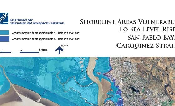


18 The Intergovernmental Panel on Climate Change predicts a 20inch rise in sea level over the next half-century


19 Eroding levee along San Pablo Bay Erosion at Tolay Lagoon Highway 37 at Tolay Levee breach during
20 Building the Corridor Context Access Congestion Multi-modal Transportation Community Environment Land-Use Health Employment Recreation Habitat Water Quality Climate Change Housing/Jobs Agriculture Smart Planning

21 Building the Corridor Context Traffic Noise Habitat Water Quality Climate Change

22 Building the Corridor Context Roadkill Habitat Water Quality Climate Change
23 Fraser Shilling UC Davis Road Ecology Center
WELCOME AND INTRODUCTIONS!
 State Route 37 Stewardship Study: Integrating Environment and Community in Transportation Planning WELCOME AND INTRODUCTIONS! Fraser Shilling, Ph.D. University of California, Davis Road Ecology Center
Highway 37 Stewardship Study Meeting #6 Draft Agenda
 Highway 37 Stewardship Study Meeting #6 Draft Agenda Meeting # 6 will focus on regional planning practices and the current scenario matrix Time Topic Presented By 9:00 Welcome and Introductions 9:15 Corridor
Estuarine Restoration in San Francisco Bay: Design and Adaptive Management. Environmental Management of Enclosed Coastal Seas
 Estuarine Restoration in San Francisco Bay: Design and Adaptive Management Environmental Management of Enclosed Coastal Seas August 31, 2011 Eric Jolliffe, Bill Brostoff, and Fari Tabatabai U. S. Army
ATTACHMENT E. Meeting Notes. June 24, 2017
 ATTACHMENT E Meeting Notes San Pablo Baylands /State Route 37 Planning Meeting June 19, 2017 10:00 am 12:00 pm Ralph Benson Baylands Center 2100 Sears Point Road, Sonoma A. Meeting Purpose: Discuss a unified,
Fraser Shilling welcomed everyone, gave a brief overview of the meeting and introduced Joy Villafranca, AECOM.
 Stakeholder Meeting #4 Minutes: Friday, August 21st, 2015 State Route 37 Integrated Traffic, Infrastructure and Sea Level Rise Analysis Marin Humane Society, 171 Bel Marin Keys Blvd. Novato, California
Summary of the Highway 37 Corridor World Cafe
 116 12 25,000 12 17,200 17,000 Summary of the Highway 37 Corridor World Cafe 121 To l a y Lakeville Highway Marin County 37 33,500 erton Avenue 35,000 San Pablo Bay October 4, 2011 Vallejo, CA 1 0.5 0
SAN FRANCISCO DISTRICT TRAVIS J. RAYFIELD, PE, PMP LIEUTENANT COLONEL, US ARMY DISTRICT COMMANDER/ENGINEER
 SAN FRANCISCO DISTRICT 1 ENGINEERING WITH NATURE SYMPOSIUM UC SANTA CRUZ 237 217 200 80 NATURAL 237 AND 217 NATURE 200 BASED 119 237 217 200 27 FEATURES 252 174.59 255 255 255 0 0 0 163 163 163 131 132
ECOSYSTEM SERVICES CREDITING STRATEGIES FOR TRANSPORTATION AGENCIES
 ECOSYSTEM SERVICES CREDITING STRATEGIES FOR TRANSPORTATION AGENCIES Jimmy Kagan Institute for Natural Resources Oregon State University & Portland State University Bobby Cochran Willamette Partnership
Role of Ecosystem Services in Watershed Management. Steve Gruber Dennis King David Moore
 Role of Ecosystem Services in Watershed Management Steve Gruber Dennis King David Moore Los Peñasquitos Lagoon Ecosystem Services within the Regulatory Framework Impairment Identified Sedimentation of
San Pablo Baylands: Ensuring a Resilient Shoreline
 San Pablo Baylands: Ensuring a Resilient Shoreline October 26, 2017 State Route 37 Baylands Group Audubon California Ducks Unlimited Friends of San Pablo Bay Wildlife Refuge Marin Audubon Point Blue Conservation
[FWS R8 R 2016 N061; FXRS282108E8PD0 167 F ] South Bay Salt Pond Restoration Project, Phase 2 at the Eden Landing Ecological
![[FWS R8 R 2016 N061; FXRS282108E8PD0 167 F ] South Bay Salt Pond Restoration Project, Phase 2 at the Eden Landing Ecological](/thumbs/88/115154959.jpg "[FWS R8 R 2016 N061; FXRS282108E8PD0 167 F ] South Bay Salt Pond Restoration Project, Phase 2 at the Eden Landing Ecological") This document is scheduled to be published in the Federal Register on 06/20/2016 and available online at http://federalregister.gov/a/2016-14565, and on FDsys.gov Billing Code: 4333 15 DEPARTMENT OF THE
This document is scheduled to be published in the Federal Register on 06/20/2016 and available online at http://federalregister.gov/a/2016-14565, and on FDsys.gov Billing Code: 4333 15 DEPARTMENT OF THE
CALIFORNIA OCEAN PROTECTION COUNCIL. Staff Recommendation June 14, San Francisco Bay Hydrodynamic and Sediment Transport Modeling
 CALIFORNIA OCEAN PROTECTION COUNCIL Staff Recommendation June 14, 2007 San Francisco Bay Hydrodynamic and Sediment Transport Modeling Developed By: Abe Doherty RECOMMENDED ACTION: Consideration of the
COASTAL CONSERVANCY. Staff Recommendation May 18, 2005 NAPA RIVER SALT MARSH RESTORATION PROJECT FINAL DESIGN FOR PHASE 2
 COASTAL CONSERVANCY Staff Recommendation May 18, 2005 NAPA RIVER SALT MARSH RESTORATION PROJECT FINAL DESIGN FOR PHASE 2 File No. 01-022 Project Manager: Amy Hutzel RECOMMENDED ACTION: Authorization to:
NOVATO FLOOD CONTROL ZONE No. 1 Marin County Flood Control and Water Conservation District
 NOVATO FLOOD CONTROL ZONE No. 1 Marin County Flood Control and Water Conservation District Photo by R. Tong. Marin IJ INFORMATION ON MEASURE E: NOVEMBER 7, 2017 PARCEL TAX MEASURE PRESENTATION TO NOVATO
Robert Brown, Community Development Director. PRESENTER: Christine O Rourke, General Plan Project Manager
 STAFF REPORT MEETING DATE: March 3, 2015 TO: FROM: City Council Robert Brown, Community Development Director 922 Machin Avenue Novato, CA 94945 (415) 899-8900 FAX (415) 899-8213 www.novato.org PRESENTER:
County of San Diego DEPARTMENT OF PARKS AND RECREATION. Administrative Office: (858) Fax: (858) Reservations: (858)
 Fax: (858) Reservations: (858)") BRIAN ALBRIGHT DIRECTOR County of San Diego DEPARTMENT OF PARKS AND RECREATION Administrative Office: (858) 694-3030 Fax: (858) 495-5841 Reservations: (858) 565-3600 www.sdparks.org NOTICE OF PREPARATION
BRIAN ALBRIGHT DIRECTOR County of San Diego DEPARTMENT OF PARKS AND RECREATION Administrative Office: (858) 694-3030 Fax: (858) 495-5841 Reservations: (858) 565-3600 www.sdparks.org NOTICE OF PREPARATION
Request for a Proposal The Bolsa Chica Lowlands Restoration Project: Sustainability Alternatives Study January 2019
 Request for a Proposal The Bolsa Chica Lowlands Restoration Project: Sustainability Alternatives Study January 2019 Introduction The Bolsa Chica Land Trust (BCLT) has applied for and been selected to receive
Climate Change Adaptation in Action
 Climate Change Adaptation in Action Incorporating Adaptation to Climate Change in Pinole s General Plan Update Synopsis Pinole, California has created a blueprint for maintaining its unique character and
Alternatives Analysis
 CHAPTER 6 Alternatives Analysis 6.1 Introduction The National Environmental Policy Act (NEPA) and the California Environmental Quality Act (CEQA) require that an Environmental Impact Statement (EIS) and
Preliminary Feasibility Study for South San Francisco Bay Shoreline Economic Impact Areas 1-10 Executive Summary
 Economic Impact Areas 1-10 Executive Summary Prepared For: Department of Water Resource Division of Flood Management State Of California Prepared By: Santa Clara Valley Water District February 2017 A preliminary
Preparing New Jersey for Climate Change
 Photo: Jane Thomas, UMCES Preparing New Jersey for Climate Change Adaptation for Watersheds, Rivers and Coasts Zoë Johnson, Office for a Sustainable Future Global Climate Change: Real Consequences Chesapeake
Integrating Sea Level Rise Considerations in the South Bay Salt Ponds Restoration Project. Norma J. Camacho Chief Operating Officer, Watersheds
 Integrating Sea Level Rise Considerations in the South Bay Salt Ponds Restoration Project Norma J. Camacho Chief Operating Officer, Watersheds Presentation Overview Mission of the District Santa Clara
DRAFT ANNOTATED OUTLINE 12/4/2006
 DRAFT ANNOTATED OUTLINE 12/4/2006 INTEGRATED WATER MANAGEMENT PLAN SAN DIEGO REGION A. INTRODUCTION AND REGIONAL WATER MANAGEMENT GROUP Summary This Integrated Regional Water Management Plan (IRWM Plan)
Multi-Benefit Planning in the San Joaquin River Basin-wide Feasibility Study
 Multi-Benefit Planning in the San Joaquin River Basin-wide Feasibility Study September 8 th, 2016 Presented by: Eric Tsai, P.E. California Department of Water Resources Eric.Tsai@water.ca.gov Jeremy Thomas,
Free Bridge Congestion Relief Project: Using FHWA s Eco-Logical Process
 Free Bridge Congestion Relief Project: Using FHWA s Eco-Logical Process An Ecosystem Approach to Developing Infrastructure Projects June 27, 2014 Charlottesville Albemarle Metropolitan Planning Organization
Appendix J. Existing Efforts for Identifying Multi-Benefit Projects
 Appendix J Existing Efforts for Identifying Multi-Benefit Projects Water Purveyor Projects Existing Efforts for Identifying Multi Benefits Projects In-lieu groundwater recharge under RWA planning efforts
TREASURE COAST REGIONAL PLANNING COUNCIL M E M O R A N D U M. To: Council Members AGENDA ITEM 5E
 TREASURE COAST REGIONAL PLANNING COUNCIL M E M O R A N D U M To: Council Members AGENDA ITEM 5E From: Date: Subject: Staff March 15, 2013 Council Meeting Intergovernmental Coordination and Review Log The
State Route 37 Integrated Traffic, Infrastructure and Sea Level Rise Analysis: Final Report
 State Route 37 Integrated Traffic, Infrastructure and Sea Level Rise Analysis: Final Report Road Ecology Center University of California, Davis http://hwy37.ucdavis.edu State Route 37 Integrated Traffic,
FHWA Climate Change Adaptation Activities
 FHWA Climate Change Adaptation Activities Southern Transportation & Air Quality Summit 2011 Raleigh, NC July 20, 2011 U.S. Department of Transportation Federal Highway Administration Heather Holsinger
1. Claim: Asphalt is not a toxic environmental hazard.
 By way of their website, press releases and various advertisements, the Dutra Group has made a variety of claims about their proposed asphalt plant at Haystack Landing. They state these opinions as if
Mitigation and Adaptation through Adaptive Conservation
 Mitigation and Adaptation through Adaptive Conservation North Bay Watershed Association Ellie M. Cohen and PRBO staff April 4, 2008 Key Points 1. Climate Change = happening now & accelerating 2. Birds
Revised 8-4. Board of Directors Water Planning and Stewardship Committee. September 11, 2007 Board Meeting. Subject. Description
 Board of Directors Water Planning and Stewardship Committee September 11, 2007 Board Meeting Subject Adopt criteria for conveyance options in implementation of Long Term Delta Plan Description Revised
How to Reduce Costs While Improving the Reliability and Quality of Water Resources. The water in a watershed is essential for supporting all life.
 Land Use and Watersheds How to Reduce Costs While Improving the Reliability and Quality of Water Resources The water in a watershed is essential for supporting all life. Mary Nichols, Director, UCLA Institute
Coastal Defense and Climate Change An overview of NatCap work and a plea for help
 Coastal Defense and Climate Change An overview of NatCap work and a plea for help Anne Guerry, Greg Guannel, Greg Verutes, Jess Silver, Joe Faries, Katie Arkema, Rob Griffin, Suzanne Langridge Annual Meeting
QUANTIFYING COASTAL ECOSYSTEM SERVICES Session 3: State of the Knowledge on Incentives of the Blue Carbon Approach
 QUANTIFYING COASTAL ECOSYSTEM SERVICES Session 3: State of the Knowledge on Incentives of the Blue Carbon Approach Katie Arkema Stanford University Workshop on Blue Carbon, July 26, 2017 National Academies
3.14 Public Services Physical Setting. Methodology
 3.14 Public Services This section of the Draft Environmental Impact Statement/Report (EIS/R) describes the existing public services within the Eden Landing Phase 2 area of the South Bay Salt Pond (SBSP)
SAN FRANCISCO DISTRICT
 LETTER REPORT SAN FRANCISCO BAY SHORELINE STUDY U.S. ARMY CORPS OF ENGINEERS SAN FRANCISCO DISTRICT,APRIL 1992 LETTER REPORT SAN FRANCISCO BAY SHORELINE STUDY U.S. ARMY CORPS OF ENGINEERS SAN FRANCISCO
CHESAPEAKE BAY COMPREHENSIVE WATER RESOURCES AND RESTORATION PLAN - UPDATE. Update to Chesapeake Bay Program STAR January 25, 2018
 CHESAPEAKE BAY COMPREHENSIVE WATER RESOURCES AND RESTORATION 255 255 255 237 237 237 0 0 0 217 217 217 163 163 163 200 200 200 PLAN - UPDATE 131 132 122 239 65 53 80 119 27 110 135 120 252 174.59 112 92
3.0 CUMULATIVE PROJECTS SCENARIO
 3.0 CUMULATIVE PROJECTS SCENARIO The CEQA Guidelines define cumulative impacts as two or more individual effects that, when considered together, are considerable or which compound or increase other environmental
The Nature Conservancy Cosumnes River Preserve Franklin Boulevard Galt CA 95632
 Study Partners The Nature Conservancy Cosumnes River Preserve 13501 Franklin Boulevard Galt CA 95632 East Bay Municipal Utility District 1 Winemaker Way, Unit K Lodi CA 95240 Sacramento County Water Agency
Nature-based Solutions in the Climate Change Tool Kit: an Example from Rangelands
 Nature-based Solutions in the Climate Change Tool Kit: an Example from Rangelands Libby Porzig PhD, Nat Seavy PhD, Tom Gardali, Ellie Cohen CCAPC August 14, 2015 Point Blue Conservation Science Advancing
Sacramento River Basin Report Card
 Sacramento River Basin Report Card FEATHER RIVER WATERSHED April 2010 Using Indicators to Measure Watershed Health Environmental, economic, and social indicators are used world-wide to report the status
FHWA Climate Change Adaptation Activities
 FHWA Climate Change Adaptation Activities Albany, NY Climate Change Workshop September 21, 2011 U.S. Department of Transportation Federal Highway Administration Diane Turchetta FHWA, Office of Natural
Wildlife Management Area
 Proposed Wildlife Management Area A wildlife management area designation is being proposed for the Harrison-Chehalis area to conserve fish and wildlife habitats while also respecting existing and compatible
Community Benefits of Land Restoration
 Community Benefits of Land Restoration Introducing Green Infrastructure for Coastal Resilience Matt Fulda, Acting Director Monroe May 23 rd, 2017 Avery Point Campus, University of Connecticut Easton Trumbull
Butano Creek Channel Reconnection and Resilience Project CEQA Process. Lead Agency: San Mateo Resource Conservation District June 27, 2018
 Butano Creek Channel Reconnection and Resilience Project CEQA Process Lead Agency: San Mateo Resource Conservation District June 27, 2018 Outline 1. Brief Project Overview 2. Project Timeline 3. CEQA Objectives/Requirements
An Overview of the NOAA Habitat Blueprint
 An Overview of the NOAA Habitat Blueprint Improving fisheries, marine life, and coastal communities through habitat conservation Designing Sustainable Coastal Habitats Workshop April 17, 2013 NOAA S HABITAT
Appendix M. Summary of Local Sea Level Rise Planning Efforts. Draft
 Appendix M Summary of Local Sea Level Rise Planning Efforts Appendix M: Summary of Local Sea Level Rise Planning Efforts Summary of Local Sea Level Rise Planning Efforts Half Moon Bay SLR Planning Efforts
Integrating Mitigation, Carbon Sequestration and Ecosystem Services at Community- relevant Scales
 Integrating Mitigation, Carbon Sequestration and Ecosystem Services at Community- relevant Scales Steve Kohlmann, PhD, Point Richmond, CA Mark Mondik, Vice President, San Francisco, CA 2050: 67% of world
Esri Ocean GIS Forum Redlands, CA Samantha Coccia-Schillo NatureServe Patrick Crist - NatureServe Chris Jeffery & Dan Dorfman- NOAA
 Esri Ocean GIS Forum Redlands, CA 2016 Samantha Coccia-Schillo NatureServe Patrick Crist - NatureServe Chris Jeffery & Dan Dorfman- NOAA Study Area Area of focus for ILSP is the Northeast Ecological Corridor
U.S. 101 / San Mateo County Smart Corridor Project
 Department of Transportation District 4 - Traffic Operations October 1, 2013 U.S. 101 / San Mateo County Smart Corridor Project www.dot.ca.gov California Department of Transportation (Caltrans) Overview
COASTAL CONSERVANCY. Staff Recommendation March 2, 2006 BALLONA WETLANDS ENHANCEMENT PLANNING. File No Project Manager: Mary Small
 COASTAL CONSERVANCY Staff Recommendation March 2, 2006 BALLONA WETLANDS ENHANCEMENT PLANNING File No. 04-088 Project Manager: Mary Small RECOMMENDED ACTION: Authorization to amend the Conservancy's December
Team Member Affiliation WEDA Member Role
 Summary: Dominion Cove Point LNG, LP (DCP) owns and operates the Cove Point Liquefied Natural Gas (LNG) Terminal (terminal), an LNG import terminal in Lusby, Maryland (Figure 1). The terminal includes
THIS IS NOT A PAID ADVERTISEMENT. Public Notice. Public Notice No. CENAP-OP-R September 7, 2017
 THIS IS NOT A PAID ADVERTISEMENT Public Notice Wanamaker Building 100 Penn Square East Philadelphia, PA 19107-3390 ATTN: CENAP-OP-R Public Notice No. Date CENAP-OP-R-2017-00042 September 7, 2017 Application
Community. Restoration. Prevention.
 Community. Restoration. Prevention. Truckee Wetlands Restoration Project Thank you to our Funders Donors to the OUR VALUES PARTNERSHIPS ECOLOGICALLY SOUND ECONOMICS Truckee River Watershed Council May
ADOPT A RESOLUTION OF THE CITY COUNCIL IN SUPPORT OF THE CALIFORNIA WATERFIX AND CALIFORNIA ECO RESTORE
 ADOPT A RESOLUTION OF THE CITY COUNCIL IN SUPPORT OF THE CALIFORNIA WATERFIX AND CALIFORNIA ECO RESTORE Presented by Gary Takara City Council September 18, 2017 Agenda Item 12 Recommendations Find that
Wastewater System Upgrades Project
 Wastewater System Upgrades Project Final Master Environmental Impact Report State Clearinghouse # 2013082006 Lead Agency: City of Modesto Utilities Department Prepared By: Jerry Haag, Urban Planner November
TABLE OF CONTENTS Brisbane Baylands Final EIR
 TABLE OF CONTENTS Brisbane Baylands Volume I 1. Introduction 1-1 1.1 Project Location 1-1 1.2 Project Overview 1-2 1.3 Format of the 1-4 1.4 Use of the in Agency Decision Making 1-5 1.5 Public Participation
CALIFORNIA COASTAL COMMISSION DRAFT SEA-LEVEL RISE POLICY GUIDANCE
 South Imperial Beach, TRNERR 1 CALIFORNIA COASTAL COMMISSION DRAFT SEA-LEVEL RISE POLICY GUIDANCE 17 September 2014 CMANC Fall 2014 Meeting Overview of Presentation 2 California and Coastal Act s Draft
LETTER G. City of San Diego
 LETTER G City of San Diego G-1 The comment provides introductory statements and acknowledges collaboration between interested stakeholders and agency representatives in the development of the proposed
Gulf of Mexico Hydrological Restoration Criteria for Identifying and Prioritizing Projects
 Gulf of Mexico Hydrological Restoration Criteria for Identifying and Prioritizing Projects Definition of hydrological restoration for this Partnership To remove or modify anthropogenic barriers to restore
Flood Protection Meets Climate Change
 Flood Protection Meets Climate Change Robin Grossinger, San Francisco Estuary Institute, robin@sfei.org Scott Dusterhoff, San Francisco Estuary Institute Julie Beagle, San Francisco Estuary Institute Climate
C-SMART: Planning for Sea Level Rise in Tomales Bay, September 23, 2016 Jack Liebster, Planning Manager, Marin County
 C-SMART: Planning for Sea Level Rise in Tomales Bay, September 23, 2016 Jack Liebster, Planning Manager, Marin County Sustainable Marin? Sea Level Rise Adaptation Process Evaluate Science Info. Implement
Roadmap to Tree Planning and Planting Dallas, TX
 Roadmap to Tree Planning and Planting Dallas, TX A New Innovative Approach to an Old Problem City Council Briefing March 4, 2009 Janette Monear, Executive Director Texas Trees Foundation Matt Grubisich,
1.0 INTRODUCTION 1.1 EIR REQUIREMENT
 This Draft Environmental Impact Report (EIR) describes the potential environmental effects that could result from implementation of the proposed Sonoma County General Plan 2020 (Draft GP 2020), which provides
Wetland Policy In Vermont and Louisiana. Litsey Corona and Emily Karwat
 Wetland Policy In Vermont and Louisiana Litsey Corona and Emily Karwat What is a wetland? An area inundated by surface or groundwater with a frequency sufficient to support plants and animals that depend
RECOMMENDATION FROM TODD ROAD WORKING GROUP
 STAFF REPORT MEETING DATE: August 8, 2006 THE CITY OF NOVATO CALIFORNIA TO: FROM: City Council Glenn Young, Public Works Director Mary Neilan, Assistant City Manager 75 Rowland Way #200 Novato, CA 94945-5054
NDCEE. Ecosystem Banking Best Practices. Elizabeth Keysar, NDCEE/CTC. National Defense Center for Energy and Environment
 NDCEE Ecosystem Banking Best Practices DoD Executive Agent Office Office of the of the Assistant Assistant Secretary of the of Army the Army (Installations and and Environment) Elizabeth Keysar, NDCEE/CTC
Notice of Preparation for the Copeland Creek Stormwater Detention Basin (CIP Project )
") Copeland Creek Stormwater Detention Basin (CIP Project 2006-04) Date: December 20, 2017 To: Public Agencies and Interested Persons From: Mary Grace Pawson, Director of Development Services, City of Rohnert
Copeland Creek Stormwater Detention Basin (CIP Project 2006-04) Date: December 20, 2017 To: Public Agencies and Interested Persons From: Mary Grace Pawson, Director of Development Services, City of Rohnert
Indirect assessment of West Coast historical tidal wetland loss
 Indirect assessment of West Coast historical tidal wetland loss PMEP Annual Meeting Seattle, Washington, USA October 2017 Laura Brophy 1, Brett Holycross 2, Van Hare 2 1 Estuary Technical Group, Institute
Estimated Influence of 2050 Climate Change on Chesapeake Bay Water Quality Standards.
 Estimated Influence of 2050 Climate Change on Chesapeake Bay Water Quality Standards. Water Quality Goal Implementation Team Meeting NCTC Shepherdstown, WV December 14, 2015 Lewis Linker 1, Gopal Bhatt
Uncovering Shared Vulnerabilities: Participant Guide
 ART BAY AREA Regional Working Group Meeting #4 June 19, 2018 Uncovering Shared Vulnerabilities: Participant Guide The assets that are being analyzed in ART Bay Area are interconnected in many ways. For
NOVATO WATERSHED PROGRAM
 NOVATO WATERSHED PROGRAM NOVATO CITY COUNCIL Photo Credit: Sue Lattanzio AGENDA OVERVIEW OF TONIGHT S TALK Slide 2 Context what is a watershed? Process how did we implement the watershed approach? Content
Information for File # ARC
 Information for File # 2015-02993-ARC Applicant Corps Contact St. Louis-Lake Counties Regional Rail Authority Andrew R. Chambers Address 600 South Lake Avenue, Suite 211, Duluth, MN 55802 E-Mail Andrew.R.Chambers@usace.army.mil
FINDING COMMON GROUND: INTEGRATING NATURE, INFRASTRUCTURE, AND PEOPLE INTO SEA-LEVEL RISE PLANNING. Laguna Bluebelt, by Mitch Ridder
 FINDING COMMON GROUND: INTEGRATING NATURE, INFRASTRUCTURE, AND PEOPLE INTO SEA-LEVEL RISE PLANNING Laguna Bluebelt, by Mitch Ridder California Adaptation Forum August 19, 2014 FINDING COMMON GROUND CALIFORNIA
COASTAL TX PROTECTION AND RESTORATION FEASIBILITY STUDY
 COASTAL TX PROTECTION AND RESTORATION FEASIBILITY STUDY Stakeholders Forum Dr. Kelly Burks-Copes, Project Manager Mr. Tony Williams, Coastal Resources US Army Corps of Engineers, Galveston District Texas
10. INDEX. South Bay Salt Pond Restoration Project December 2007 Final Environmental Impact Statement/Report
 10. INDEX A Adaptive management, ES-4, ES-17, ES-18, ES-20, ES-54, ES-55, ES-56, 1-23, 3.1-5, 3.1-6, 3.3-45, 3.3-51, 3.3-52, 3.3-53, 3.3-55, 3.3-64, 3.3-65, 3.3-71, 3.4-25, 3.4-30, 3.4-45, 3.4-56, 3.4-58,
Sacramento County Board of Supervisors Sacramento County Water Agency. October 21, 2008
 Sacramento County Board of Supervisors Sacramento County Water Agency October 21, 2008 Adopt Resolutions Approving the Sacramento County and the Sacramento County Water Agency Policies With Respect to
Testimony of Shari T. Wilson, Secretary Maryland Department of the Environment. Before. The Senate Committee on Environment and Public Works
 Testimony of Shari T. Wilson, Secretary Maryland Department of the Environment Before The Senate Committee on Environment and Public Works The Clean Energy Jobs and American Power Act (S. 1733) Wednesday,
Outcomes. Kelly Karll-SEMCOG Margaret Barondess - MDOT
 Eco-Logical: I-75 Corridor I-75 Conservation Transportation Action Planning in to Monroe Achieve County: Multiple Stormwater Environmental Considerations Outcomes Kelly Karll-SEMCOG Karll@semcog.org Margaret
MARTINSVILLE SOUTHERN CONNECTOR STUDY CITIZEN INFORMATION MEETING Magna Vista High School 701 Magna Vista School Road Ridgeway, Virginia May 8,
 MARTINSVILLE SOUTHERN CONNECTOR STUDY CITIZEN INFORMATION MEETING Magna Vista High School 701 Magna Vista School Road Ridgeway, Virginia 24148 May 8, 2018 MEETING OVERVIEW AND OBJECTIVES Introduce study
DEFINITIONS KEY FINDINGS COMMUNITY ADAPTATION PLANNING FOR CHANGING LANDSCAPES & CLIMATE. For more information visit
 KEY FINDINGS & IMPLICATIONS FOR TAKING ACTION DEFINITIONS Community Adaptation is a planning process designed to improve the capacity of local communities to adapt to changing conditions. It requires an
CHAPTER TWO PROJECT SUMMARY
 2.1 INTRODUCTION CHAPTER TWO PROJECT SUMMARY This section provides a brief summary of the Proposed Project and its impacts in accordance with California Environmental Quality Act (CEQA) guidelines. As
FACT SHEET. The UC Davis Biosentinel Mercury Program. The Fish Mercury Project
 The Fish Mercury Project The UC Davis Biosentinel Mercury Program Using Small Fish to Monitor Fine-scale Patterns of Methylmercury Contamination in the Watershed Principal Investigator Dr. Darell Slotton
Habitat. Summary and Accomplishments. Claude Lafrance St. Clair River RAP Coordinator
 Summary and Accomplishments Claude Lafrance St. Clair River RAP Coordinator St. Clair River AOC Symposium The Path to a Healthy River Working Towards Delisting the St. Clair River June 7, 2012 Sarnia,
Los Cerritos Wetlands Oil Consolidation and Restoration Project
 Volume 1a: Responses to Comment and Draft EIR Revisions Los Cerritos Wetlands Oil Consolidation and Restoration Project Final Environmental Impact Report State Clearinghouse #2016041083 Prepared for City
J O I N T P U B L I C N O T I C E
 J O I N T P U B L I C N O T I C E CHARLESTON DISTRICT, CORPS OF ENGINEERS 69A Hagood Avenue Charleston, South Carolina 29403-5107 and THE S.C. DEPARTMENT OF HEALTH AND ENVIRONMENTAL CONTROL Office of Ocean
Chapter 5 Transportation Draft
 Chapter 5 Transportation Draft Discussion Similar to the other elements in the Comprehensive Plan, the transportation element impacts the quality of life, economic development and public safety of the
NEW YORK NEW JERSEY HARBOR AND TRIBUTARIES COASTAL STORM RISK MANAGEMENT
 NEW YORK NEW JERSEY HARBOR AND TRIBUTARIES COASTAL STORM RISK MANAGEMENT 237 217 200 80 237 217 200 119 FEASIBILITY 237 217 200 STUDY 27 255 0 163 131 239 110 112 62 102 130 National Environmental Policy
Goals of This Orientation
 East Contra Costa County Habitat Conservation Plan / Natural Community Conservation Plan (HCP/NCCP) HCP/NCCP Orientation for Project Proponents and Scientific Consultants January 9, 2008 John Kopchik (Contra
Adapting to Rising Tides
 Access on and off Bay Farm Island and to and from Oakland International Airport (OAK) is already limited due to the island s geography, is vulnerable to future flooding and seismic events, and will affect
AMENDED Memorandum of Understanding for Integrated Regional Water Management in the Monterey Peninsula, Carmel Bay, and South Monterey Bay Region
 AMENDED Memorandum of Understanding for Integrated Regional Water Management in the Monterey Peninsula, Carmel Bay, and South Monterey Bay Region 1. PURPOSE The purpose of this Memorandum of Understanding
Landscape-Level Mitigation
 Landscape-Level Mitigation From Greenprints to RAMP: A multiple benefit approach Liz O Donoghue, The Nature Conservancy July 15, 2014 The Problem Population increase Infrastructure development Increased
Draft Environmental Impact Report
 Revised Draft Environmental Impact Report San Francisquito Creek Flood Protection, Ecosystem Restoration, and Recreation Project Upstream of Highway 101 This notice announces that a Draft Environmental
Prioritizing Climate Change Impacts and Action Strategies
 Prioritizing Climate Change Impacts and Action Strategies Chesapeake Bay Program STAC December 8, 2015 2014 Chesapeake Bay Agreement CLIMATE RESILIENCY GOAL: Increase the resiliency of the Chesapeake Bay
SRCD s Review of Impacts the Proposed Bay Delta Conservation Plan (BDCP) and Companion EIR/EIS on the Suisun Marsh
 and Companion EIR/EIS on the Suisun Marsh") SRCD s Review of Impacts the Proposed Bay Delta Conservation Plan (BDCP) and Companion EIR/EIS on the Suisun Marsh By Steve Chappell, Executive Director Suisun RCD BDCP Document is Extremely Challenging
SRCD s Review of Impacts the Proposed Bay Delta Conservation Plan (BDCP) and Companion EIR/EIS on the Suisun Marsh By Steve Chappell, Executive Director Suisun RCD BDCP Document is Extremely Challenging
Southern Sonoma County Storm Water Resource Plan
 DRAFT Southern Sonoma County Storm Water Resource Plan Implementation Strategy May, 2018 0 Funding has been provided in full or in part through an agreement with the State Water Resources Control Board
Public Notice U.S. Army Corps In Reply to Application Number NAB-OP-RMS(WSSC JOHN HANSON HIGHWAY) Baltimore District
 Baltimore District") Public Notice U.S. Army Corps In Reply to Application Number of Engineers NAB-OP-RMS(WSSC JOHN HANSON HIGHWAY) Baltimore District 2012-61326 PN 13-60 Comment Period: October 2, 2013 to November 2, 2013
Public Notice U.S. Army Corps In Reply to Application Number of Engineers NAB-OP-RMS(WSSC JOHN HANSON HIGHWAY) Baltimore District 2012-61326 PN 13-60 Comment Period: October 2, 2013 to November 2, 2013
Environmental Impact Statement; Lone Star Regional Rail Project Williamson, Travis, Bastrop, Hays, Caldwell, Comal, Guadalupe, and Bexar Counties, TX
 This document is scheduled to be published in the Federal Register on 10/06/2014 and available online at http://federalregister.gov/a/2014-23711, and on FDsys.gov [4910-22] DEPARTMENT OF TRANSPORTATION
Engineering Excellence 2016
 A first in the world, a small infinity loop is being constructed at the Port of Vancouver in British Columbia. ODOT s new Transportation System Plan Guidelines represents one of the first digital online