Robert Brown, Community Development Director. PRESENTER: Christine O Rourke, General Plan Project Manager
|
|
|
- Cuthbert Barton
- 6 years ago
- Views:
Transcription

1 STAFF REPORT MEETING DATE: March 3, 2015 TO: FROM: City Council Robert Brown, Community Development Director 922 Machin Avenue Novato, CA (415) FAX (415) PRESENTER: Christine O Rourke, General Plan Project Manager SUBJECT: SEA LEVEL RISE AND ADAPTATION WHITE PAPER REQUEST Consider providing direction to staff on sea level rise and adaptation policy and program options for inclusion in the Draft General Plan and associated Environmental Impact Report. RECOMMENDATION Provide direction to staff. SUMMARY The Sea Level Rise and Adaptation White Paper is the eighth in a series of white papers being prepared to assist in updating the Novato General Plan. The purpose of the white paper process is to provide initial direction on key policy issues, which will aid staff in crafting policies for the draft General Plan and then eventual evaluation in an environmental impact report (EIR). As such, the Planning Commission's recommendations and City Council direction are preliminary and will be reconsidered upon review of the draft General Plan and its accompanying EIR. The Sea Level Rise White Paper provides: background information on sea level rise trends and projections; an overview of federal, State and regional responses to sea level rise; a description of planning studies and adaptation strategies underway in Marin; a high-level assessment of Novato areas at risk for sea level rise by mid-century and beyond; and an overview of potential adaptation strategies. POLICY OPTIONS The Sea Level Rise White Paper describes tasks and actions to consider for incorporation into new General Plan policies and programs. The primary program options discussed in the Sea Level Rise White Paper are: cc15_037 1
2 1. Stay Current on Data a. Update GIS maps to include new data as it becomes available (e.g., update of FEMA FIRM maps, mapping areas of vulnerability, mapping inventory of levees and shorelines); utilize GIS as a tool for tracking and make available to the public. b. Complete an accurate inventory of levees and shorelines. Include baseline information on County-maintained levees such as topographic surveys (elevation and cross-sectional data), geotechnical data (soil profile of the embankment and the underlying strata), overall physical condition, and an inventory of associated structures (access roads, tide gates, culverts, etc.) 2. Monitor and Participate in Studies and Efforts Underway a. Work with and participate in the County of Marin Public Works Department Novato Creek Watershed Project. b. Monitor updates to FEMA FIRM Maps; document changes as needed and inform affected property owners; continue participation in the FEMA National Flood Insurance Program Community Rating System. c. Maintain the Hamilton levee s FEMA accreditation. 3. Prioritize Preparation of a Vulnerability and Risk Assessment a. Identify local, County, state and regional agencies with Bay and shoreline oversight; participate in coordinating a collective effort, partnership and/or assistance in preparation of a vulnerability assessment. Participate in proportional funding for an assessment, if available. b. Investigate and determine Public Works Department staff resources needed to participate in preparation of a vulnerability and risk assessment for Novato. c. Identify stakeholders and initiate early outreach. d. Identify vulnerable infrastructure (utilities, roadways, etc.) and structures at risk for inundation. 4. Investigate and Pursue Funding Sources for Staffing, Studies and Adaptation a. Monitor and pursue funding opportunities such as federal grants and regional grants. 5. Assess the potential impacts of sea level rise in all applications for new development in shoreline areas. a. Adopt requirements to assess sea level rise risks and design projects to cope with projected flood levels. cc15_037 2
3 6. Prepare a guidance document for incorporating sea level rise into the City s capital planning process. 7. Incorporate the likelihood of sea level rise and extreme heat and storm events in the City s Local All-Hazard Mitigation Plan. ENVIRONMENTAL ASSESSMENT No environmental assessment is necessary for the policy white papers being prepared for the update of the General Plan. However, an environmental impact report will be prepared for the draft General Plan, which will include an analysis of the preliminary policy direction and alternatives developed through the white paper process. ALTERNATIVES 1. Direct staff to incorporate desired policy options into the Draft General Plan; or 2. Direct staff to provide additional analysis and recommendations. ATTACHMENTS 1. Sea Level Rise and Adaptation White Paper cc15_037 3


4 City of Novato General Plan 2035 Policy White Paper SEA LEVEL RISE AND ADAPTATION March 2015 Photo Credit: Randall Cohen 4
5 WHITE PAPER PURPOSE The General Plan white papers are intended to inform and elicit discussions regarding key policy issues relevant to updating the 1996 Novato General Plan. The policy direction provided through the white paper process is considered to be preliminary and will be used by staff when crafting policies and programs for the draft General Plan. All draft policies and programs will be reconsidered upon review of the draft General Plan and its accompanying environmental impact report (EIR). EXECUTIVE SUMMARY This document presents a white paper on the topic of sea level rise. This topic has been a growing concern in the last decade as studies continue to report and confirm its direct connection to climate change associated with global warning. This paper was prepared as a first step in responding to the City of Novato Climate Change Action Plan (CCAP), which was adopted in A discussion of the CCAP and these programs is provided in Section III of this paper. Section III also summarizes other measures that the City of Novato has employed or identified to address flooding such as the Safety element within the City of Novato s General Plan, and the City of Novato s Multi-Hazard Mitigation Plan. This white paper is not a technical study nor is it a detailed quantitative analysis of sea level rise or its potential impacts on the community. Further, this paper does not present answers or solutions to sea level rise in Novato. Rather, this paper has been prepared to provide information that can be used in understanding this issue and moving forward to the next steps for long-range planning. This paper: a) identifies the key agencies that have been involved in studying and planning for this topic; b) presents the most current information and studies on sea level rise, particularly in the Bay Area; c) identifies potential funding sources to pursue for next steps; d) summarizes the studies underway in Marin and the North Bay; e) describes techniques and tools that have been developed for adaptation; f) identifies the City of Novato s shoreline and levees areas to study, as well as potential opportunity areas for studying adaptation; and g) presents suggestions for next steps in moving forward with preparing a vulnerability assessment and long-term adaptation strategies for sea level rise. There are a number of federal, state, regional and county agencies as well as one North Bay organization that are currently addressing or studying sea level rise and related issues such as flooding. These efforts are presented in Section II of this paper. The Bay Conservation and Development Commission (BCDC) has been in the lead with its initial publication of sea level prediction maps in Also, at the regional level, the Association of Bay Area Governments (ABAG) and the Metropolitan Transportation Commission (MTC) have joined to prepare a Sustainable Communities Strategy (SCS) required by Senate Bill 375. Known as the Plan Bay Area, this SCS includes, among others, the formation of a Joint Policy Committee (JPC), which is a collaboration of four regional agencies working to develop: a) tools for conducting vulnerability and sea level rise assessments; b) a sea level adaptation strategy; and c) a funding plan for counties and local jurisdictions to plan for and assess sea level rise. There is an abundance of studies, reports and assessments that have been prepared on sea level rise since the 2007 publication of the BCDC prediction maps. Section IV of this paper provides a summary of studies and assessment efforts that have been completed since 2007, with the primary City of Novato Sea Level Rise and Adaptation White Paper i 5
6 focus on the Bay Area. Most notable is a 2011 risk assessment pilot project completed for the Alameda County shoreline, which was sponsored by BCDC, MTC and Caltrans. Known as the ART (Adapting to Rising Tides) Project, this pilot project has established a template for other pilot projects and for the preparation of sub-regional vulnerability assessments. SPUR, a Bay Areabased, member-supported non-profit organization, has completed several reports and publications. One of the publications (2009) identifies seven adaptive strategies for addressing sea level rise, which are suited to the Bay Area conditions. One of the biggest challenges to assessing and planning for sea level rise is funding. Section IV of this paper provides a list of available and possible funding sources for pursuing studies and adaptation. Funding sources and grant opportunities for studies include, among others: Government Issue (GI) bonds, FEMA, the California Emergency Management Agency (CalEMA), and the California Coastal Conservancy. Funding sources for construction (e.g., adaptation) include the US Army Corps of Engineers (funding shoreline restoration projects), the Coastal Conservancy and the North Bay Watershed Association. The major take-away regarding the availability of grants is that the City must have a current, adopted Multi-Hazard Mitigation Plan. These plans are required to be updated every five years. The City s current Multi-Hazard Mitigation Plan was last updated in There are a number of on-going pilot programs and studies underway in Marin County, which are discussed in Section V of this paper. Most notable is the Richardson Bay Pilot Program, initiated by the Marin County Department of Public Works in Rather than focusing on assessing vulnerability, the pilot program has employed actual engineering concepts at bay front locations along the Richardson Bay. This program includes the Aramburu Beach/Island Restoration Project, the first demonstration project of its kind in the Bay Area. This demonstration project is designed to test natural shoreline approaches to monitor wind and wave erosion, as well as sea level rise. Further, Marin County Supervisor Kate Sears has initiated and is implementing a vulnerability assessment pilot program for the Tamalpais Valley and Marin City areas (Southern Marin Vulnerability Assessment Pilot Program). This pilot program primarily uses the BCDC ART Project template with a more grassroots approach that involves community input through all phases of the program. Closer to home, the County of Marin Department of Public Works is overseeing the Novato Creek Watershed Program, which is studying flood protection and wetland restoration, which are both tied to planning for predicted sea level rise. Finally, the City s Storm Drain Master Plan will include new drainage design standards that take into account sea level rise. There have been a number of adaptation measures and tools that have been developed and tested to combat or plan for sea level rise. Section VI of this paper provides a description of some of the measures that have been developed, with some tested locally. Phillip Williams and Associates (now ESA-PWA), a Bay Area environmental planning and engineering firm, has been in the forefront by introducing measures such as retreat - levee relocation (moving levees inland) and the horizontal levee (conversion of mudflats/tidelands to marsh). Other, more conventional measures include barriers (sea walls, tidal gates) and raising levees. The City of Novato s shoreline and levees are diverse, and there are expansive areas that are vulnerable to projected sea level rise. Appendix A of this paper broadly identifies the levees and shorelines areas. This paper also includes areas that are vulnerable to sea level rise and are worthy of study for adaptation. These areas are described in Section VI and Appendix B of this paper. City of Novato Sea Level Rise and Adaptation White Paper ii 6
7 Please note that the areas presented in the appendices were not identified based on engineering studies or technical data, but on historic knowledge and familiarity with the community. This paper presents a number of challenges that need to be acknowledged and considered before preparing a vulnerability assessment. As summarized in Section VII of this paper, long term planning for sea level rise cannot be done in isolation; it will require the collaborative effort of multiple agencies. Given the expanse of area that would be affected by predicted sea level rise, the number of stakeholders is substantial. Thirdly, the City of Novato s shoreline and levee conditions substantially vary by area, so a one-size-fits-all approach is not possible. Further, there are limited City resources and funding. Lastly, this paper provides a list of suggested next steps (see Section VIII) which include, among others, a City commitment to prioritize and staff the preparation of a vulnerability assessment. City of Novato Sea Level Rise and Adaptation White Paper iii 7
8 TABLE OF CONTENTS I. INTRODUCTION & PURPOSE...1 II. SEA LEVEL RISE TRENDS AND PROJECTIONS...1 III. BACKGROUND...2 A. Federal Level... 2 B. State Level... 5 C. Regional & County Levels... 7 IV. BRINGING IT TO A LOCAL LEVEL A. City of Novato s General Plan B. Novato s Climate Change Action Plan Adaptation Measures C. City of Novato s Hazard Mitigation Plan D. GIS MapGuide System V. WHAT HAS BEEN STUDIED AND EXPLORED IN THE BAY AREA AND BEYOND A. Studies and Assessment Efforts Completed to Date B. Lessons Learned from Completed Assessments C. Approaches and Tools to Conducting a Vulnerability Assessment D. Strategies in Managing Sea Level Rise VI. CURRENT STUDIES AND STRATEGIES UNDERWAY IN MARIN A. Richardson Bay Pilot Program B. C-SMART C. Southern Marin Vulnerability Assessment Pilot Program D. Novato Watershed Program E. Marin Climate & Energy Partnership (MCEP) VII. ASSESSING LOCAL CONDITIONS AND OPPORTUNITIES A. Identifying Novato s Levees and Shorelines B. Mapping Sea Level Rise Scenarios for Novato C. Identifying Adaptation Strategies Potentially Suitable for Novato VIII. CHALLENGES IX. PROGRAM OPTIONS City of Novato Sea Level Rise and Adaptation White Paper iv 8
9 APPENDICES Appendix A. Appendix B. Appendix C. Appendix D. Appendix E. Novato s Levees and Shorelines Vulnerable Buildings and Infrastructure Sea Level Rise Impacts on Selected Areas Funding Sources and Regulatory Requirements Bibliography & Acknowledgements LIST OF FIGURES 1 Figure 1: City of Novato and Vicinity FEMA "Areas of Special Flood Hazard," Figure 7: Example of FEMA Flood Zone GIS Overlay in MarinMap Figure 8: Retreat-Levee Relocation Figure 9: Horizontal Levee, Cross-Section Figure 10: Horizontal Levee Figure 2: Northern Novato, 2-Foot Sea Level Rise Figure 3: Central Novato, 2-Foot Sea Level Rise Figure 4: Southern Novato, 2-Foot Sea Level Rise Figure 5: Highway 101 and 37 Interchange, 50-Centimeter (20-Inch) Sea Level Rise Figure 6: Highway 101 and 37 Interchange, 50-Centimeter (20-Inch) Sea Level Rise with 20- Year Storm City of Novato Sea Level Rise and Adaptation White Paper v 9
10 I. INTRODUCTION & PURPOSE In the past decade, there have been groundbreaking studies and an increased public awareness on the worldwide effects of climate change associated with global warming. Studies continue to document that global warming is continuing at progressive rates, which has been demonstrated by warmer and colder seasonal temperatures and patterns of more severe seasonal storm events. It is projected that sea levels will continue to rise as precipitation continues to increase and ice caps continue to melt. While we will not be able to stop the rise in sea levels resulting from these changes, we have the opportunity and must plan to adapt to this change. There are a number of large geographic areas within the City of Novato that are at risk for flooding and will be dramatically impacted by sea level rise. These geographic areas include valley floors, properties with low-lying elevations (some at or below sea level), and areas that are now filled and were once marshland. Most of these areas are developed so returning them to original, natural state is not a viable option. To this end, the effects of sea level rise, while viewed as a climate problem is a people problem; the focus must be on adaptation, to plan for and protect vulnerable populations and neighborhoods. Starting with the big picture, there is a need to identify what is going to happen, how fast is it going to happen, and what can be done about it. The purpose of this paper is to: a) Identify key agencies that have some level of oversight on this topic; b) Provide a summary of resources and data prepared and available to date on the topic of sea level rise; c) Preliminarily identify vulnerable areas within the City of Novato that require further study, and potential areas for adaptation; d) Report on what has been or is being studied and pursued in the Bay Area to date; and e) Identify possible next steps for the City of Novato to complete a vulnerability assessment. II. SEA LEVEL RISE TRENDS AND PROJECTIONS The San Francisco Bay is vulnerable to a range of natural hazards, including storms, extreme high tides, and rising sea levels resulting from global climate change. Flooding already poses a threat to communities along the Bay and there is compelling evidence that these risks will increase in the future. As temperatures rise globally, sea levels are rising mainly because ocean water expands as it warms, and water from melting major stores of land ice like ice sheets and glaciers flow into the ocean. In the past century, average global sea level has increased by 17 to 21 centimeters (7 to 8 inches), and sea level at the San Francisco tidal gauge has risen 20 centimeters (8 inches). 1 1 California Coastal Commission, Sea-Level Rise Policy Guidance, Public Review Draft, October 14, City of Novato Sea Level Rise and Adaptation White Paper 1 10
11 Rising seas put new areas at risk of flooding and increase the likelihood and intensity of floods in areas that are already at risk. The State s Sea-Level Rise Guidance Document recommends using a range of 4 to 30-centimeter (2 to 12-inch) sea level rise increase by 2030 and 12 to 61-centimeter (5 to 24-inch) increase by These recommendations are based on the scientific findings of the National Research Council (NRC) Sea-Level Rise for the Coasts of California, Oregon, and Washington released June 2012 and shown in Table 1. Table 1: Regional Sea Level Rise Projections Relative to Year 2000 Sea Level Rise (inches) NRC 2012 Projection (mean ± the standard Low Year deviation for the A1B (mean of the B1 scenario) scenario 3 ) High (mean of the A1F1 scenario) (±2) (±4) (±10) Source: National Research Council (NRC), Sea-Level Rise for the Coasts of California, Oregon, and Washington, June Planning for sea level rise involves not only protecting existing structures and resources but ensuring new projects are designed to adapt to potential sea level rise. Factors to consider for any future coastal facility or infrastructure project include: 1. The projected lifespan of the project or facility; 2. The cost or value of the project or a replacement facility; and 3. The impact or consequence of damage to or loss of a facility or project. III. BACKGROUND As a global issue, sea level rise crosses over a number of federal, state, regional and county agencies. The following is a brief summary of the key agencies that are currently involved in studying and planning for this hazard. A. Federal Level Congress passed the National Flood Insurance Act of 1968 and the Flood Disaster Protection Act of 1973 to address the increasing cost of flood-related disaster relief. The intent of the National Flood Insurance Program (NFIP) is to reduce the need for large, publicly-funded flood control structures and disaster relief by restricting development on floodplains. 2 Coastal and Ocean Working Group of the California Climate Action Team, State of California Sea-Level Rise Guidance Document, March The A1 scenario family assumes high economic growth, low population growth that peaks mid-century, and the rapid introduction of more efficient technologies. A1B is balanced and A1F1 is fossil fuel intensive. The B1 scenario family assumes the same low population growth as the A1 scenarios, but a shift toward a loweremission service and information economy and cleaner technologies. City of Novato Sea Level Rise and Adaptation White Paper 2 11
12 The Federal Emergency Management Agency (FEMA) administers the NFIP to provide subsidized flood insurance to communities that comply with FEMA regulations and limit development on floodplains. FEMA issues Flood Insurance Rate Maps (FIRMs) for communities participating in the NFIP. FIRMs delineate flood hazard zones in the community. Executive Order (Floodplain Management) addresses floodplain issues related to public safety, conservation and economics. It requires federal agencies constructing, permitting or funding a project in a floodplain to: avoid incompatible floodplain development; maintain consistency with the standards and criteria of the NFIP; and restore and preserve natural and beneficial floodplain values. Historically, local and county jurisdictions have relied on and deferred to FEMA to document and map areas that are prone to flooding. Generally, every five to six years, FEMA updates and publishes Flood Insurance Rate (FIRM) Maps identifying flood prone areas and zones of vulnerability. As discussed below, the next preliminary update of the FIRM maps for the City of Novato will be completed and released in 2014, however a commenting and review period will last until sometime in The FIRM maps delineate several flood zones, which are defined as follows: Zones A, AE, AH, AO, AR, A99, V and VE (referenced as Areas of Special Flood Hazard ) areas subject to 1% chance of flooding in any given year (formerly referred to as the 100- year flood zone) Zone X areas subject to 0.2% chance of flooding in any given year and areas protected by levees from the 1% chance of flooding in any given year Zone D areas where flood hazards are undetermined, but possible The FIRM maps play several critical roles. First, the maps are used by local and county agencies to identify and plan for local or area flood protection. Second, the maps are used by the banking and insurance industries to determine if flood insurance is mandated for a specific property or area. Lands located within the Areas of Special Flood Hazard require that flood protection insurance be secured for federally-regulated or insured loans. Lastly, the maps are used at the federal and state level to plan for waterway projects that are administered by the US Army Corps of Engineers. The most current FIRM maps that are available were updated and published in For all lands within the FEMA 100-year flood zone, construction is required to comply with elevation regulations. The 2009 FEMA regulations require a finished floor height elevation for buildings of +9.0 National Geodetic Vertical Datum (NGVD). This finished floor elevation requirement is applied to all new construction and is also required for substantial renovations or additions to existing buildings. As a matter of precaution, the City of Novato s policy and practice is to require an additional 1-foot of elevation ("freeboard") above the FEMA standard. FEMA is in the process of updating the FIRM maps for Marin County. FEMA issued preliminary maps for public review in May 2014 and held community workshops in June The final FIRM maps will be issued in September Following this round of FIRM map updates, FEMA will be changing the finished floor height elevation thresholds for flood zone delineation and federal requirements for protective levees. FEMA has reported that the new regulations (expected to be adopted for application next year) will require a finished floor height elevation of North American Vertical Datum of 1988 (NAVD), which is City of Novato Sea Level Rise and Adaptation White Paper 3 12

13 being administered to address, in part, more detailed and technical information available on tidal and wave action. Therefore, it is expected that the geographic boundaries of the flood zones will increase or change. A sample map of a portion of the City of Novato is provided in Figure 1. This map delineates Areas of Special Flood Hazard, noted on the map as 100 Year Flood Zones. Figure 1: City of Novato and Vicinity FEMA "Areas of Special Flood Hazard," 2013 City of Novato Sea Level Rise and Adaptation White Paper 4 13
14 With the exception of the bayfront levee improvements along the former Hamilton Airfield in Novato, none of the existing Marin bay front levees meet the predicted federal standards for height or type. The City s Hamilton Field Levee is currently accredited by FEMA and the City is in the process of re-accreditation in light of the proposed FIRM updates. B. State Level In 2006, the State Legislature passed and former Governor Arnold Schwarzengger signed AB 32, the Global Warming Solutions Act of This action established a law mandating a statewide reduction of greenhouse gas (GHG) emissions by While AB 32 focuses on reducing GHG emissions, not rising sea levels, it was a landmark action as it is the first State law to establish mandates for combating global warming. Bay Conservation and Development Commission (BCDC) The Bay Conservation and Development Commission (BCDC) is a state agency that provides regulatory authority over the San Francisco Bay. Operating since 1970, BCDC is responsible for implementing and enforcing the San Francisco Bay Plan and has review and permit authority over baylands and upland areas within 100 feet of the shoreline. In 2011, BCDC adopted policies to deal with the expected impacts of climate change in San Francisco Bay, summarized below: Risk Assessments: Sea level rise risk assessments are required when planning shoreline areas or designing larger shoreline projects. If sea level rise and storms that are expected to occur during the life of the project would result in public safety risks, the project must be designed to cope with flood levels expected by mid-century. If it is likely that the project will remain in place longer than midcentury, the applicant must have a plan to address the flood risks expected at the end of the century. Risk assessments are not required for repairs of existing facilities, interim projects, small projects that do not increase risks to public safety, and infill projects within existing urbanized areas. Risk assessments are only required within BCDC s jurisdiction. Risk assessments for projects located only in the shoreline band, an area within 100 feet of the shoreline, need only address risks to public access. Sea Level Rise Projections: Risk assessments must be based on the best estimates of future sea level rise. The National Research Council s sea level rise projections, 4 ranging from 5-24 inches at midcentury and inches at the end of the century, currently provide the best available sea level rise projections for the West Coast. However, scientific uncertainty remains regarding the pace and amount of future sea level rise, and project applicants may use other sea level rise projections if they provide an explanation. 4 National Research Council (NRC), Sea-Level Rise for the Coasts of California, Oregon, and Washington, June City of Novato Sea Level Rise and Adaptation White Paper 5 14
15 Protecting Existing and Planned Development: Fill may be placed in the Bay to protect existing and planned development from flooding as well as erosion. New projects on fill that are likely to be affected by future sea level rise and storm activity during the life of the project must: Be set back far enough from the shoreline to avoid flooding; Be elevated above expected flood levels; Be designed to tolerate flooding; or Employ other means of addressing flood risks. Designing Shoreline Protection: Shoreline protection projects, such as levees and seawalls, must be designed to withstand the effects of projected sea level rise and to be integrated with adjacent shoreline protection. Whenever feasible, projects must integrate hard shoreline protection structures with natural features that enhance the Bay ecosystem, e.g., by including marsh or upland vegetation in the design. Preserving Public Access: Public access must be designed and maintained to avoid flood damage due to sea level rise and storms. Any public access provided as a condition of development must either remain viable in the event of future sea level rise or flooding, or equivalent access consistent with the project must be provided nearby. Ecosystem Protection and Restoration: Where feasible, ecosystem restoration projects must be designed to provide space for marsh migration as sea level rises. Encouraging Resilient Development: The policies encourage projects if their regional benefits, such as reducing carbon emissions by locating jobs and housing near public transportation, outweigh the risk from flooding. Projects that do not negatively impact the Bay and do not increase risks to public safety, such as repairs, small and interim projects, and parks, are also encouraged. Preserving Undeveloped Areas: The policies encourage preservation and habitat enhancement in undeveloped areas that are vulnerable to future flooding and contain significant habitats or species, or are especially suitable for ecosystem enhancement. Regional Strategy. The policies call on the Commission, working with other agencies and the general public, to develop a regional strategy for Protecting critical developed areas along the shoreline from flooding; Enhancing the natural resources of the Bay by preserving existing habitat and identifying areas where tidal wetlands can migrate landward; and Improving the ability of communities to adapt to sea level rise in ways that advance economic prosperity, social equity and environmental protection. BCDC has taken a lead in developing a Local Government Adaptation Assistance Program (AAP) to provide information and resources to Bay Area local and regional governments to assist them in planning for and adapting to the impacts of a changing climate. These outreach efforts primarily focus on addressing the needs of land use planning, public works, park and open space districts, flood control districts and wastewater authorities, as well as resource-based managers. The longterm goal of the AAP is to help San Francisco Bay Area communities achieve coordinated and regional adaptation to climate change impacts. The AAP contributes to this goal by building capacity City of Novato Sea Level Rise and Adaptation White Paper 6 15
16 within local governments to assess climate change issues, and to plan for and implement adaptation strategies. BCDC has identified five broad program components for accomplishing these AAP objectives: (1) building partnerships that cut across jurisdictional boundaries, both geographic and sectorial; (2) public outreach to build community and institutional support for adaptation planning; (3) education to help planners and managers develop knowledge and skills for adaptation planning; (4) creation of a one-stop shop website and information clearinghouse; and (5) development and dissemination of strategies to improve the region s resilience and adaptive capacity. C. Regional & County Levels Plan Bay Area - Strategy for a Sustainable Region The Bay Area, which encompasses nine counties, is served by a number of regional agencies, including the Association of Bay Area Governments (ABAG) and the Metropolitan Transportation Commission (MTC). ABAG and MTC manage, administer and oversee regional planning and transportation matters. In 2008, Governor Schwarzenegger signed Senate Bill 375 (SB 375), which promoted a direct linkage of regional transportation plans with the statewide goals to reduce GHG emissions. SB 375 requires that metropolitan transportation organizations such as MTC develop a Sustainable Communities Strategy (SCS), which is to serve as a new element of the regional transportation plan. The goal of the SCS is to reach a GHG reduction target for each region. The transportation emissions target for the Bay Area is a 7% GHG reduction per capita by 2020 and a 15% reduction per capita by For the Bay Area region, the SCS process involves a partnership of four regional agencies MTC, ABAG, BCDC and the Bay Area Air Quality Management District (BAAQMD). MTC and ABAG led the SCS effort with the preparation of the Plan Bay Area Strategy for a Sustainable Region (Plan Bay Area). The final Plan Bay Area was adopted by MTC and ABAG on July 18, While most of the Plan Bay Area addresses ways to achieve reductions in GHG emissions through tools such as concentrated growth ( Priority Development Areas ) and funding strategies to promote increased transit use, it includes a section addressing climate adaptation and sea level rise. The Plan promotes, endorses and commits to regional efforts through a Joint Policy Committee (JPC) comprised of representatives from MTC, ABAG, BCDC and BAAQMD. The JPC is commissioned to work collectively to conduct vulnerability and risk assessments and a sea level adaptation strategy, and develop a Transportation Asset Management Plan to provide funding to counties and local jurisdictions for planning and assessments. In 2011, the JPC was given direction to produce a Bay Area Climate and Energy Resilience Project to provide guidance on how to include protecting the Bay Area s economy, public health, infrastructure and ecosystems from sea level rise, water shortages, high energy prices and other impacts in longterm regional and local planning, including Plan Bay Area. In May 2013, the project was completed, presenting a six-month Needs Assessment and a proposed Action Plan. The findings from the Needs Assessment are contained in five reports: Stakeholder Interview Summary (including an inventory of nearly 100 Bay Area projects) City of Novato Sea Level Rise and Adaptation White Paper 7 16
17 Mapping Our Future: A Work Plan for Public Engagement and Social Equity Bay Area Integrated Win-Win Strategies (resilience and GHG reduction) What s Going to Happen and What Can We Do About It? (science information for decisionmakers) Effective Governance for Multi-Jurisdictional, Multi-Sector Climate Adaptation The 12-Month Action Plan outlines a five-point plan to significantly accelerate and strengthen Bay Area adaptation planning. The plan will now be used to engage funders and supporters in discussions on moving forward. The reports and action plan can be accessed at In September 2012, the JPC adopted a work plan to develop a Regional Sea Level Rise Adaptation Strategy. The objective of this project is to: ensure the ongoing health and ecological viability of regional natural resources, such as San Francisco Bay; coordinate adaptation mechanisms that transcend local jurisdictional boundaries; and share the costs of adaptation responses at a regional level, especially when regional resources are involved. The sea level rise adaptation strategy work plan focuses on providing enough background information and support to develop a bottom-up regional strategy where the regional agencies work with local entities to assess vulnerabilities and risks, identify critical assets, explore adaptation options, and use a balanced approach to identify costs, benefits and adaptation strategies for the natural resources/ecosystem services provided by the Bay and its watersheds. The lessons learned from these collaborative efforts will be used to inform the second iteration of Plan Bay Area and be fully integrated into the third iteration. County of Marin The County of Marin Department Public Works (including Flood Control) takes the lead on addressing countywide issues related to flood control/protection and water quality. More recently, some of this work has transitioned into addressing sea level rise. The County manages over nine flood control zones, including one covering the City of Novato (Zone 1), which includes both incorporated and unincorporated lands. These are independent assessment districts formed for the sole purpose of addressing flood control. In 2008, the Marin County Watershed Program was initiated as a project of the Marin County Department of Public Works. This watershed program covers all major developed watersheds in Marin including the Novato Creek and Rush Creek watersheds. The goals of this program are as follows: Partner with local municipalities, agencies and non-profits System-wide analysis of flood protection options Identify multi-benefit type projects Protect, enhance and restore habitat and water quality Improve efficiency of flood control maintenance operations Evaluate the beneficial re-use of dredged material Identify sea level rise adaptation strategies Work with the natural watershed processes The base of this program is stakeholder engagement. The program utilizes three working groups/committees which are: a Policy Advisory Committee which includes elected officials; a City of Novato Sea Level Rise and Adaptation White Paper 8 17
18 Technical Working Group which includes staff from participating and regulatory agencies with a science and technical background; and an Operations and Finance Committee that evaluates progress and sets priorities. Some of the goals are to develop models and other tools, potential alternatives and funding strategies. The funding partners include, among others, the County of Marin, the City of Novato, the City of San Rafael, the City of Mill Valley and several of the flood control and service districts. A 10-year work plan has been developed for this program, which includes the Novato Watershed Program. This project is discussed under Section V of the paper (Current Studies and Strategies Underway in Marin). For more information on the Marin County Watershed Program, please see the Marin County website at 5 North Bay Watershed Association (NBWA) While not a regulatory agency, the North Bay Watershed Association (NBWA) is a membership group of 16 regional and local public agencies located throughout Marin, Sonoma, and Napa counties, including the City of Novato (Associate Member), the North Marin Water District, and the Novato Sanitary District. NBWA is committed to crafting a set of regional approaches to the problems and issues associated with managing the North Bay watersheds. The mission of NBWA is to facilitate partnerships across political boundaries that promote stewardship of the North Bay watershed resources. The NBWA was created to help regulated local and regional public agencies work cooperatively on water resources issues that impact areas beyond traditional boundaries in order to promote stewardship of the North Bay watershed. Agencies participate in the NBWA in order to discuss issues of common interest, explore ways to work collaboratively on water resources projects of regional concern, and share information about projects, regulations and technical issues. More recently, NBWA has been in the forefront of researching and addressing sea level rise. In 2013, NBWA commissioned PRBO, environmental consultants, to prepare a report on adapting to sea level rise. This report is summarized in Section IV below. 5 Meeting with Marin County Department of Public Works; December 16, 2013 City of Novato Sea Level Rise and Adaptation White Paper 9 18
19 IV. BRINGING IT TO A LOCAL LEVEL A. City of Novato s General Plan The City addresses flooding, dam and levee failure, and rising sea level hazards in the Safety element of the General Plan. The element seeks to reduce flood risks by maintaining effective flood storm drainage systems and regulating construction. In addition, the element includes the following policy and program specifically related to sea level rise: SF Policy 11 Rising Sea Level. Consider the potential for sea level rise when processing development applications that might be affected by such a rise. SF Program 11.1: Work with the County Flood Control and Water Conservation District to prepare a plan for responding to a potential rise in sea level. Consider developing flood control projects and modifying the City s land use regulations for areas subject to increased flooding from sea level rise. Consider the potential for sea level rise when process B. Novato s Climate Change Action Plan Adaptation Measures In response to AB 32, the City of Novato embarked on preparing a Climate Change Action Plan (CCAP) in The CCAP was prepared with the assistance and participation of the City of Novato Sustainability Committee and stakeholders. Adopted in 2009, the CCAP sets forth steps and implementing measures to combat and/or adapt to climate change. Chapter 5 of the CCAP contains goals and adaptation measures to address sea level rise as follows: GOAL 9 Novato will become resilient to climate change. Improve the City s resilience to reduce vulnerability to extreme events resulting from climate change. Adaptation Measure 1: Incorporate climate change threats, impacts, projections, adaptation needs, and strategies in the General Plan, hazard mitigation plans, emergency response and preparedness plans, development plan review, capital project planning, and other ongoing activities as appropriate. 1.1 Coordinate internally and with water districts, wildlife agencies, flood control and fire districts, Marin County, and other relevant organizations. Address human health and the health and adaptability of natural systems, including the following: a. Water resources including expanded rainwater harvesting, water storage and conservation techniques, water reuse, desalination, and water-use and/or irrigation efficiency. b. Biological resources including land acquisition, creation of marshlands/wetlands as a buffer against sea level rise and flooding, and protection of existing natural barriers. c. Public health including heat-related health plans, vector control, safe water, and improved sanitation. d. Environmental hazards including seawalls, storm surge barriers, and fire protection. City of Novato Sea Level Rise and Adaptation White Paper 10 19
20 Adaptation Measure 2: Identify and reassess regional climate change vulnerabilities. 2.1 On a regular basis, work with neighboring cities, counties, and regional agencies to establish more uniform approaches to addressing climate change. Adaptation Measure 3: Prepare for sea level rise. 3.1 Cooperate with the San Francisco Bay Conservation and Development Commission (BCDC) and other regional agencies preparing for sea level rise, coastal erosion, and peak storm events. C. City of Novato s Hazard Mitigation Plan The City of Novato Hazard Mitigation Plan, adopted and approved by FEMA in 2011, analyzes risks posed to people and property in Novato by natural and man-made hazards, and presents a list of mitigation strategies that the City can implement prior to such events occurring. Flooding is prioritized as a high risk. The plan addresses flooding that occurs from a temporary rise in stream flow, resulting in water overtopping stream banks and inundating areas adjacent to the channel. In particular, Novato Creek is identified as having a long history of flooding and representing the main flood hazard to the community. Additionally, the plan identifies flood risks that may occur when winter storms generate heavy wave action along the bay coastal areas of Novato which, either by itself or when combined with high tides and/or high winds, initiate flooding along the coastline. Although the plan does not directly address inundation risks due to sea level rise, there are several programs related to sea level rise, including programs to: limit development in floodplains; require development in the 100 year flood zone to comply with federal, state and local codes; and work with the Marin County Flood Control District to ensure that structural projects for flood control are considered. The City is required to update the Hazard Mitigation Plan every five years, and will have an opportunity to more comprehensively address sea level rise risks at that time. D. GIS MapGuide System The City will be utilizing MarinMap s Geographic Information System (GIS) software in 2015, which provides mapping of the City and the neighboring unincorporated areas. MarinMap is programmed to provide assessor parcel-based data such as property zoning, land use, property ownership, parcel size, etc. The program includes sea level rise (based on the NOAA maps described on page 5) and FEMA flood zone information. MarinMap will be updated to incorporate the FEMA flood zone mapping that is currently being prepared. A public viewer is available on MarinMap at An example of a location showing FEMA flood zones from MarinMap s GIS Map Guide Program is shown in Figure 7. City of Novato Sea Level Rise and Adaptation White Paper 11 20

21 Figure 2: Example of FEMA Flood Zone GIS Overlay in MarinMap V. WHAT HAS BEEN STUDIED AND EXPLORED IN THE BAY AREA AND BEYOND A. Studies and Assessment Efforts Completed to Date Since the 2006 publication of the BCDC sea level prediction maps, there have been numerous reports and studies commissioned and completed to address climate adaptation for sea level rise. This section summarizes what has been prepared that is relative to the Bay Area and may be applicable and valuable for long-term planning in Novato. This section presents these studies and resource documents in chronological order. In 2009, BCDC, the Association of Bay Area Governments (ABAG) and the San Francisco Bay National Estuarine Research Reserve presented Preparing for Sea Level Rise: Planning Sustainable Communities, which recommended the inclusion of the Marin bayside into the Baylands Corridor and the need to develop detailed mapping and analysis for determining vulnerability and strategies for long-term adaptation. City of Novato Sea Level Rise and Adaptation White Paper 12 21
22 In 2009, the County of Marin adopted the Marin Countywide Plan, which includes mapping, analysis and policies to limit development and access and control shoreline modification among other strategies. While the Marin Countywide Plan Baylands Corridor designation and policies are primarily focused on the protection of biological resources, water quality and flood protection, the issue of sea level rise is inherent in the Plan. The County of Marin has indicated that the Baylands Corridor will likely be a good planning tool to address sea level rise and adaptation. County staff will be reviewing the Baylands Corridor designation and policies for this purpose. In 2009, SPUR, a Bay Area-based, member-supported non-profit organization, completed its first report on the topic of sea level rise. Entitled Strategies for Managing Sea Level Rise, this report weighs the advantages and disadvantages of seven strategies for managing sea level rise. The seven adaptive strategies assessed are barriers, coastal armoring, elevated development, floating development, floatable development, living structures and managed retreat. See the section below entitled Strategies in Managing Sea Level Rise for a description of these strategies. In 2010, the City of Hayward contracted with Philip Williams & Associates, Ltd (PWA) to conduct a Preliminary Study of the Effects of Sea Level Rise on the Resources of the Hayward Shoreline. The study includes a map and analysis of each water management function, described by location and including the types of and proximity to hazards, mode of failure, and severity and risk of damage. It also identified three possible adaptation strategies: hold-the-line (levee construction), realignment (move levees inland), and gradual steeping (provides a mechanism to increase surface elevation at about the rate of sea level rise). The study found realignment and gradual steeping strategies preferable adaptation methods because of the various implementation benefits. Following these results, the study identified next steps for Hayward including a more detailed assessment of coastal hazards to specific infrastructure to gauge vulnerability based on the proximity of future erosion and flooding hazard zones to facilities. In 2011, BCDC, MTC and the State Department of Transportation (Caltrans) commissioned the preparation of Adapting to Rising Tides: Transportation Vulnerability and Risk Assessment Pilot Project (with technical assistance of AECOM, consultants). Known as the ART Project, this pilot study includes a partnership with the National Oceanic and Atmospheric Administration Coastal Service Center, with funding from the Federal Highway Administration and ICLEI. The ART Project assessed the highly varied and diverse shoreline in Alameda County (Emeryville to Union City), defining five shoreline categories based on their primary physical characteristics, functions and abilities to inhibit inland inundation. The five categories are: engineered flood protection structures (e.g., levees, sea walls); engineered shoreline protection structures (e.g., bulkheads, revetments); non-engineered berms (e.g., salt pond and agricultural berms); wetlands; and natural non-wetland shorelines (e.g., beaches, cliffs). The following are two fundamental take-aways from the ART Project: The shoreline categories developed for Alameda County reasonably encompass the range of shoreline types found throughout the nine-county San Francisco Bay Area. Non-engineered berms are common around the San Francisco Bay shoreline, including within Novato. Non-engineered berms protect marshes, ponds and agricultural areas from wave erosion and provide flood protection to inland developments. These berms are often comprised of Bay mud that has been excavated from the Bay floor and piled and/or stacked City of Novato Sea Level Rise and Adaptation White Paper 13 22
23 in a mound. Many non-engineered berms have been in place around the Bay for several decades, with some dating back over 100 years. Most berms are periodically maintained to compensate for settlement, erosion, failure and rising sea levels. Several areas around the Bay contain extensive networks of non-engineered berms that provide multiple lines of flood defense between the Bay and developed areas. However, the non-engineered nature of their construction typically classifies them as highly vulnerable to sea level rise and seismic events. The ART Project template has been structured to implement a phased planning process as follows: 1. Scope & Organize. Identify and convene partners and stakeholders; define planning area. 2. Assess. Inventory and assess conditions. 3. Plan. Identify appropriate adaptation strategies 4. Implement & Monitor. Progress has been made on the ART Project. In 2012, a Vulnerability and Risk Assessment Report was completed. More recently, in December 2013, BCDC published two documents: 1) ART Vulnerability & Risk: The Define Step; and 2) ART Developing an Adaptation Response: The Plan Step. These documents serve as starting points for further adaption planning that will need to occur at multiple scales in the region. The next steps of ART involve working with partners throughout the Bay Area to utilize the tools, resources and lessons learned from the ART pilot project to assist resilience planning efforts that address specific sectors, neighborhoods and assets, as well as the broader resilience planning that is underway in the region. In 2011, SPUR completed a second report on sea level rise entitled Climate Change hits home: Adaptation Strategies for the San Francisco Bay Area, which reviews sea level rise by sector impacts. This report recommends conducting shoreline risk assessments and preparing coastal inundation maps while revising local general plans so that policies relating to climate change hazards and sea level rise are included. In 2012, the California Emergency Management Agency, California Natural Resources Agency, and the Federal Emergency Management Agency developed California adaptation planning guide: Planning for Adaptive Communities. The guide recommends assessing climate change impacts, identifying areas most vulnerable, and developing reasonable and rational risk reduction strategies at both a regional and local level. The guide also includes nine steps for conducting a vulnerability assessment, which are listed as follows: Phase I- Identifying Conditions and Risks Step 1. Exposure: What climate change effects will a community experience? Step 2. Sensitivity: What aspects of a community (functions, structures, and populations) will be affected? Step 3. Potential Impacts: How will climate change affect the points of sensitivity? Step 4. Adaptive Capacity: What is or can be currently done to address the impacts? Step 5. Risk and Onset: How likely are the impacts and how quickly will they occur? Phase II- Developing Adaptive Strategies Step 6. Prioritize Adaptive Needs: Which impacts require actions to address them? City of Novato Sea Level Rise and Adaptation White Paper 14 23
24 Step 7. Identify Strategies: Which strategies should be pursued to address adaptation needs? Step 8. Evaluate and Prioritize Strategies: Which strategies should be implemented first? Step 9. Phase and Implement: How can the strategies be funded, staffed and monitored? In 2013, the North Bay Watershed Association (NBWA) commissioned PRBO Conservation Science, environmental consultants, to prepare Adapting to Sea Level Rise Along the North Bay Shoreline, which examined tidal marsh sites from Richardson Bay to the Upper Petaluma River, including the Novato Creek area. PRBO had previously developed and published the Future San Francisco Bay Tidal Marsh Climate Smart Planning Tool (2011), which NBWA had commissioned PRBO to use in the North Bay shoreline study. This report presents excellent information that is specific to North Bay conditions. The purpose of the North Bay shoreline report is to demonstrate how the PRBO planning tool could be used by agencies responsible for coastal areas in North San Francisco Bay to develop adaptive management plans. Two NBWA workshops were held that brought together 50 managers, scientists and other stakeholders from groups in the North Bay to identify what information they needed, but currently lacked, to make decisions. As a result of feedback gathered in these workshops and a pre-workshop survey, the NBWA established the following goals for this study: Address the ecosystem value of tidal marshes by estimating the amount by which they attenuate incoming waves; Analyze tidal marshes and other sites of interest in the North Bay region by calculating projected marsh composition, wave attenuation, and tidal marsh bird abundance; Add summary reports containing data for 344 tidal marshes across San Francisco Bay to PRBO s sea level rise decision support tool ( and Produce more detailed vulnerability assessments (including estimates of adaptive capacity) for three case study areas selected as being of high interest to workshop participants: Novato Creek, Inner Richardson Bay, and Gallinas Creek. PRBO had previously produced models of sea level rise in San Francisco Bay that looked at projected tidal elevations five times over the next 100 years (2030, 2050, 2070, 2090 and 2110). Uniquely, these models include not only the rate of sea level rise but also the rate of marsh accretion due to the deposition of suspended sediment and organic material. PRBO has found that marsh accretion serves to offset the effects of sea level rise, as it causes increases in marsh elevation that can potentially match losses due to sea level rise. Adapting to Sea Level Rise Along the North Bay Shoreline found that there are opportunities in the Novato Creek watershed for tidal marsh restoration which could be resilient to high rates of sea level rise with adaptation actions. Initial elevations of restoration projects within the watershed should be raised to allow the marshes a better chance of keeping pace with sea level rise. ] In 2013, the environmental firm of ESA-PWA completed Analysis of the costs and benefits of using tidal marsh restoration as a sea level rise adaptation strategy in San Francisco Bay, which assigned financial value to tidal marshes for restoration cost-benefit analysis. The goal of the Marin Conservation League and the San Francisco Bay Area Wetlands Restoration Project is to restore at least 100,000 acres of wetlands within the footprint of the Bay s original tidal marshes as 92% have been lost. The report indicated two cost effective strategies in adapting to sea level rise: City of Novato Sea Level Rise and Adaptation White Paper 15 24
, while restoring a 200-foot-wide marsh is about $6.3 million per mile.")
25 Retreat- Levee Relocation. The first is a levee and wetland strategy that suggests moving the levee to a new location further inland. The total cost for a new levee is over $12 million per mile (over 50 years), while restoring a 200-foot-wide marsh is about $6.3 million per mile. Figure 3: Retreat-Levee Relocation Source: ESA-PWA, 2013 Horizontal Levee. The second strategy is a horizontal levee shoreline management system, which has an estimated total cost of $6.3 million per mile (over 50 years). The horizontal levee shoreline management system (levee, wetland and upland ecotone slope ) would increase in elevation over time, enhance the ability of the flood risk management system to keep pace with sea level rise and reduce damage to the levee, thus reducing maintenance costs. The report demonstrated that complete tidal marshes have a better ability to provide a broad range of ecosystem and economic services; yet if restoration is delayed for too long, it may be unable to keep pace with expected sea level increases and fail to provide the desired benefits. City of Novato Sea Level Rise and Adaptation White Paper 16 25


26 Figure 4: Horizontal Levee, Cross-Section Source: ESA-PWA, 2013 Figure 5: Horizontal Levee Source: ESA-PWA, 2013 Lastly, in 2013, the San Francisco Bay Conservation and Development Commission and Corte Madera Baylands contracted with ESA-PWA to prepare Conceptual Sea Level Rise Adaptation Strategy for the Corte Madera Baylands. The study reviewed existing literature and utilized field City of Novato Sea Level Rise and Adaptation White Paper 17 26
27 measurements and one- and two-dimensional modeling to determine current tidal marsh and future response to sea level rise. A geomorphic conceptual model was used to identify alternative management measures for key processes of Baylands evolution and resilience. Currently, waves entering Corte Madera Bay were reduced in height and energy by roughly 80% by the time they reached the marsh edge. Both historic and restored tidal marshes are keeping pace with sea level rise; however, modeling studies suggest that they will not keep pace with accelerated sea level rise. The Corte Madera shoreline has already retreated inland by an average of 485 feet over the past 153 years and marsh habitats will continue to downshift until they are eventually lost and convert to mudflat before the end of the century. Further research is necessary to determine how much increase in sea level rise the marshes can handle. B. Lessons Learned from Completed Assessments A review of sea level rise literature offers regional and national lessons that can be applied at the local level. The following section details recommendations on choosing sea level rise predictions, areas and infrastructure of concern, partnerships and communication. Sea Level Rise predictions and models for California are 11 (±4 ) by 2050 and 36 (±10 ) by 2100 (NRC, 2012). Locally, the Corte Madera Baylands study discussed above projected sea level rise rates of 6 by 2030, 11 by 2050, and 36 by 2100 (ESA PWA 2013b). Due to the uncertainty in identifying the exact quantity of sea level rise, regional studies suggest developing sea level rise models through an inclusive public process (PWA, 2010) and creating several sea level rise scenarios that include considerations for the amount of sea level rise and variability (ICLEI, 2012). Overall, regional studies recognize an increase in depth, duration and frequency in baylands inundation and erosion (SFBCDC and ESA PWA, 2013), with the greatest threat from storms that occur in tandem with high tides (ESA-PWA, 2013). The City of Novato s main transportation corridors (Highway 101 and Highway 37) are threatened by sea level rise and inundation. According to the 2011 SPUR Report, Climate Change hits home: Adaptation Strategies for the San Francisco Bay Area, about half of the roads in the Bay Area are at risk of inundation and 60% of the state s railroads are at risk of a 100-year flood event. Additionally, wastewater treatment plants on the shoreline, such as the Novato Sanitary District, are vulnerable to a rise in sea level. The development of a countywide adaptation plan is recommended to ensure projects are resilient to predicted 2100 sea level rise. Regional partnerships have developed to address and adapt to sea level rise. BCDC, ABAG and the San Francisco Bay National Estuarine Research Reserve have developed a plan to help protect the Baylands corridor through mapping, analysis and policies to limit development, access and shoreline modifications among other measures. Additionally, the California Emergency Management Agency provides tools to increase partnerships such as Cal Adapt (cal-adapt.org), which provides local profiles, climate change tools, data and other resources. Furthermore, the California Emergency Management Agency, the California Natural Resource Agency, and the Federal Emergency Management Agency have indicated the importance of engaging a wide variety of stakeholders in order for vulnerability assessment strategies to be adopted, equitable and implemented efficiently (2012). City of Novato Sea Level Rise and Adaptation White Paper 18 27
28 To increase communication of sea level rise measures, the Bay Area Climate & Energy Resilience Project calls for a Bay Area Campaign. The Campaign would make the case for climate change adaptation work and would tell a single science-based story explaining the impacts of climate change. The campaign should emphasize short-term and long-term benefits and demonstrate why it is not just a government issue (Riordan, Bruce, n.d). In developing the campaign, establishing a climate change adaptation public outreach and education program is necessary because this campaign requires community support so the potential consequences are understood. It is recommended that communication focus on raising public awareness to the potential threats of climate change and the community benefits of taking action to achieve tangible outcomes. C. Approaches and Tools to Conducting a Vulnerability Assessment There is a wealth of sea level rise vulnerability assessment studies. Regionally and around the world, organizations have conducted assessments to better understand the impacts and possible strategies in addressing sea level rise vulnerabilities. Following is a description of the various approaches used in determining vulnerability and categorizing risk. Spatial Assessment of Impacts on Environmental and Socioeconomic Systems. In 1999, Klein, R. and Nicholls, R. focused on biogeophysical affects when conducting a vulnerability assessment. Their report, Assessment of Coastal Vulnerability to Climate Change, focused on knowing the spatial and temporal dynamics of biogeophysical affects (flood frequency, erosion, inundation, rising water tables, saltwater intrusion and biological effects) that trigger impacts and recommended including anticipated impacts and available adaptation options as well as environmental and socioeconomic systems. Map-Based Assessment and Inventory of Watershed. In 2012, the engineering firm of Aldaron Laird Trinity Associates created a GIS database to inventory and map existing shoreline conditions, assess existing shoreline vulnerability, and identify land uses and infrastructure that could be affected in Humboldt Bay. In the report, Humboldt Bay: shoreline inventory, mapping and sea level rise vulnerability assessment, the inventory included the location of tidal and upland boundary, distribution of shoreline attributes, presence of water control structures, and salt marsh. The database analysis determined that dikes are actively eroding, unmaintained, or with surfaces that are regularly overtopped. Previous fortification and rehabilitation of dikes did not offer protection from rising sea levels above 3-6 feet, with a 6-foot rise in water levels, concluding that nearly 94% of the dikes would fail to hold back rising tidewater. Participatory Citizen Engagement and Capacity-Building. A participatory approach has also been the focus of two sea level rise vulnerability assessments. The first study was conducted in 2011 by the UNHabitat Cities and Climate Change Initiative, Negombo, Sri Lanka: Climate Change Vulnerability Assessment. The purpose of the participatory approach was to build the citizen capacity to address city vulnerability to climate change scenarios and develop adaptation strategies. Data was collected through focus group discussions, interviews, field and participatory mapping, and GPS surveys. The study attempted to relate global predictions using local accounts of historic data and previous events to emphasize the evidence of climate change impacts in the city. This process was chosen to enable increased mobilization of effective local actions. In 2012, ICLEI Local Governments for Sustainability City of Novato Sea Level Rise and Adaptation White Paper 19 28
29 utilized a participatory approach to engage multiple stakeholders in developing Sea Level Rise Adaptation Strategy for San Diego Bay. A steering committee was organized to list guiding principles and develop milestones and deliverables. Multiple workshops and subgroup meetings were held. An adaptation working group was formed with representatives from public agencies that provided opportunities for stakeholder engagement, outreach and education to build capacity while promoting a regional research agenda. Sector Vulnerability Analysis. The 2009 and 2011 SPUR reports (discussed above) reviewed sea level rise vulnerabilities by sector and created a storm vulnerability index (authored by Santos, M., Rio, L. & Benavente, J.). The index provides a rapid assessment of vulnerability and exposure levels and is based on location to pin-point areas of action (2013). The aforementioned approaches demonstrate useful practices that may be adopted for the City of Novato s sea level rise vulnerability assessment. The general message in these approaches is that there is not one approved method for conducting a sea level rise vulnerability assessment. However, it is important that the assessment method meet the goals and needs of the community being assessed. D. Strategies in Managing Sea Level Rise Based on the results of various vulnerability assessments, several agencies have created a list of possible strategies in managing sea level rise. The California Emergency Management Agency, California Natural Resources Agency, & FEMA provide examples of management actions with descriptions, factors to consider, sources of information, examples of applications, funding sources, sector overlaps and co-benefits detailed by sector in their report, California adaptation planning guide: identifying adaptation strategies (2012). The following list includes recommendations dealing specifically with sea level rise. Review any existing communitywide health assessments to evaluate their responsiveness to climate change impacts. Utilize mapping technologies to identify vulnerable neighborhoods, show differential exposures to the health-damaging impacts, and examine from a geographical equity perspective with GIS. Refine emergency preparedness and response to address health impacts. Incorporate climate change risks into existing emergency preparedness plans and designs. Public health agencies should evaluate proposed/implemented climate adaptation strategies related to public health. Require accounting of sea level rise in all applications for new development in shoreline areas. Preserve undeveloped and vulnerable shorelines. Develop coordinated plans for mitigating future flood, landslide and related impacts through concurrent adoption of updated general plan safety elements and local hazard mitigation plans. City of Novato Sea Level Rise and Adaptation White Paper 20 29
30 Update general plan elements to reduce potential losses of life and property from existing and increased flooding and landslide risks. Implement AB 167 (2002) requiring flood hazard information in the local general plan. Restore existing flood control and riparian corridors. Convert concrete-lined channels to soft bottomed waterways, install landscaping on embankments to slow flood water, provide natural planting to encourage biodiversity, and build retention basins for percolation into aquifers. Implement general plan safety elements through zoning and subdivisions practices that restrict development in floodplain and landslide hazard areas. Minimize or avoid development in 100-year floodplain or landslide areas. Update plans that manage community infrastructure systems to include assessments of climate change impacts on community infrastructure. Create a hot spots map that identifies critical locations in infrastructure systems with economic risks and costs. Use low impact development stormwater practices in areas where storm sewers may be impaired by high water due to sea level rise or flood waters. Conduct an assessment to identify stormwater outfalls most likely to be flooded. Additionally, as briefly discussed above, the 2009 SPUR report Strategies for Managing Sea Level Rise identified seven strategy measures to consider for long-term shoreline protection. These strategies are discussed below, which have their advantages and disadvantages: Barrier a large dam, gate or lock that manages tidal flows in and out of the Bay. Barriers protect a large area of land in a single sweep with no social equity issues; however, they are expensive and ecologically damaging, and they may not work. Coastal Armoring linear protection such as levees and seawalls that fix the shoreline in its current place. Coastal armoring can be used in combination with other strategies; however, it is a short-term solution requiring costly annual maintenance and regular monitoring. Additionally, armored shorelines are more vulnerable to erosion and increase erosion of nearby beaches. Elevated Development raising the height of land or existing development and protecting it with coastal armoring. Allows structures to be built in vulnerable areas; however, this is a short-term strategy. Floating Development structures that float on the surface of the water or may be floated during a flood. This strategy is largely invulnerable to changing tides, but structures do not work well in places subject to wind and wave action from storms. City of Novato Sea Level Rise and Adaptation White Paper 21 30
31 Floodable Development structures that are designed to withstand flooding or to retain stormwater. This strategy is designed to resist damage with retention areas for ocean surges or heavy rainfall that catch water and slowly release it. This strategy is experimental and polluted stormwater is a public health hazard that requires combined sewer systems and new treatment facilities to ensure the released water meets water quality standards. Living Shorelines wetlands are the natural shoreline formation and absorb floods, slow erosion, provide habitat, and are essential for estuarine health. Requires at least 100,000 acres of tidal wetlands, and the San Francisco Bay currently has 73,000 acres. Managed Retreat the planned abandonment of threatened areas near the shoreline is used when other efforts have become too expensive or are thought to be a losing battle. Minimizes human suffering and is less expensive than armoring strategies, but causes a loss of coastal property values, legal and equity issues, and may require significant clean-up costs. Some of these strategies may or may not be suitable for the Marin County Bay shoreline because of cost, environmental factors, existing development and feasibility. VI. CURRENT STUDIES AND STRATEGIES UNDERWAY IN MARIN A. Richardson Bay Pilot Program In 2010, the Marin County Department of Public Works initiated a pilot program in the Richardson Bay. Rather than focusing on assessing vulnerability, the pilot program employed actual engineering concepts at bay front locations along Richardson Bay. The goals of the pilot program have been to: a) provide the education and engineering basis for adaptation planning; b) describe options along with their opportunities and constraints; c) determine costs; d) anticipate impacts; e) identify and plan for permitting; and f) prepare for grants as they become available. Part of the pilot program effort has been the Aramburu Beach/Island Restoration Project, which was built in The first demonstration project of its kind in the San Francisco Bay, it is designed to test natural shoreline approaches to wind and wave erosion, as well as sea level rise. The demonstration project involves the construction of a gravel/cobble beach with a sandy foreshore, as well as the use of wood micro groins (tree stumps). This project is currently being monitored. B. C-SMART The Marin County western coastline is predicted to be subject to combined effects of sea level rise, more intense storms, extreme high tides and more coastal erosion. The State of California has invited local governments to apply for funding support to begin to understand, assess and prepare for these possibilities. The County of Marin, in partnership with affected local communities and leading organizations working on these issues, has proposed C-SMART (Collaboration on Sea-level Marin: Adaptation Response Team) to begin the process of responding to this challenge. C-SMART is overseen by the Marin County Community Development Agency. The C-SMART team includes the Marin County Department of Public Works, Office of Emergency Services, the County Counsel s office, the Gulf of the Farallones National Marine Sanctuary, the U.S. Geological Survey, the U.S. City of Novato Sea Level Rise and Adaptation White Paper 22 31
32 National Park Service, Point Blue Conservation Science, the Federal Emergency Management Administration, and the Coravai research and consulting firm. In November 2013, the California Ocean Protection Council (OPC) awarded $1.3 million to seven local governments, which includes a $250,000 grant to C-SMART. The project will evaluate the potential risks to homes, businesses, public facilities (including Highway 1) as well as coastal resources such as shoreline wetlands, beaches and recreational areas that could be subject to inundation and damage from extreme storm surge events and projected sea level rise. While C-SMART is not relevant to the Novato bayfront, the formula, process and output of this effort may be useful for future planning along the Bay shoreline. The take-aways include: a) assembling the right team for this project; b) finding the funding sources to conduct the project; and c) developing the appropriate scope for the study. C. Southern Marin Vulnerability Assessment Pilot Program The County of Marin is implementing a vulnerability assessment pilot program for Tamalpais Valley and Marin City entitled, Climate Change, Sea Level Rise, Resilience and Adaptation: How can we best prepare to meet the challenges ahead? Initiated and sponsored by Marin County Supervisor Kate Sears, the project seeks to address how climate change impacts of sea level rise and storm events will affect these southern Marin communities, infrastructure, ecosystems and economy, and develop strategies to pursue to reduce and manage these risks. The project area focuses on the portion of Mill Valley that touches Richardson Bay at the SASM Sewage Treatment Plan, continues along Shoreline Highway to Tamalpais Valley, and then south to Marin City. The area was selected for its diverse shoreline features, the presence of a regionally-significant transportation infrastructure that includes US 101 and State Highway 1, as well as a wide variety of public, private, commercial and recreational assets. While this pilot program primarily uses the BCDC ART Project template, the unique approach to this pilot program is that there is the commitment to engage the entire community through outreach in order to educate, share data and information, and obtain feedback. Using a grassroots approach, it is the intent of this program to ultimately develop relevant adaptation strategies with the assistance of the community. As a pilot program, it is hopeful that this project will develop a template for other similar efforts throughout Marin County. A 12 to 13-member steering committee has been formed that is comprised of community members, County of Marin Department of Public Works staff and BCDC staff. County and BCDC staff provide the scientific data and projections, mapping and strategies; these are shared with the steering committee for comment and feedback. Ultimately, the steering committee will identify and evaluate possible adaptation strategies that take into account social, economic, environmental, jurisdictional, recreational and health impacts. 6 D. Novato Watershed Program As discussed in Section II above, in 2008 the County of Marin initiated the Marin County Watershed Program for five of Marin s developed watersheds (Novato, Gallinas, Ross Valley, Southern Marin 6 Meeting with Marin Co Supervisor Sears, Supervisor Aides Maureen Parton and Leslie Alden; December 18, 2013 City of Novato Sea Level Rise and Adaptation White Paper 23 32
33 and Stinson Beach). One of the projects is the Novato Watershed Program. Its purpose is to identify opportunities to integrate flood protection goals with creek and wetland restoration elements. This process includes evaluating alternatives that would reduce flood protection maintenance costs and impacts and be resilient to sea level rise. The first phase of work will provide a unified hydrology and hydraulics model and the development of conceptual project alternatives. A contract was awarded to Kamman Hydrology & Engineering to prepare an existing conditions report which included data acquisition, topographic surveys and development of hydraulic models. The report is available at The third and final phase will evaluate three alternatives that support flood protection, water quality improvements and habitat restoration. This third phase of work will begin this fall and completion is anticipated in the spring of A GIS-based database will be developed to identify habitat restoration opportunities and assist with project prioritization. Once the multi-benefit alternatives are identified, it is anticipated a revenue measure will be proposed to fund implementation. This work would also support efforts to secure grant funds. More information on the program is available at the Marin County Watershed Program s website at E. Marin Climate & Energy Partnership (MCEP) Efforts are underway to coordinate a county-wide approach to adaptation to sea level rise. The Marin Climate & Energy Partnership (MCEP), a consortium of all Marin cities and some other agencies in Marin working on climate projects, in December 2013, convened a meeting of entities on behalf of the ABAG Joint Policy Committee (JPC). The intent of the meeting was to identify the major projects and priorities in Marin County that the JPC could support through a planned resource hub, which would offer financial, technical and informational resources and guidance to local efforts to mitigate and adapt to climate change. A major discussion point was adaptation and sea level rise, and representatives from the County were there to offer insights on the projects they are involved with in the county regarding vulnerability assessments and other planning programs. MCEP has a goal to understand the current state of planning with regard to adaptation and sea level rise in order to become grant ready in 2014 to augment the efforts in the most efficient way. VII. ASSESSING LOCAL CONDITIONS AND OPPORTUNITIES A. Identifying Novato s Levees and Shorelines Novato has a diversity of shoreline and bayfront conditions. Conditions range from flat shorelines that are developed with levees and sea walls to steep uplands that drop to tidelands. Further, there are low-lying areas of the City that are developed, but are vulnerable to sea level rise because they were formerly tidelands or tidal marsh. A broad, general review of the Novato bayfront and shoreline conditions has been completed and is surveyed in Appendices A and B. The information in this paper is not based on technical engineering studies of the levees or shorelines. Rather, the following areas of Novato have been identified based on general, long-term knowledge of the community and past history of flooding, inundation and infrastructure failure during past storm events and high tides: City of Novato Sea Level Rise and Adaptation White Paper 24 33
34 Northern Novato Susceptible areas at lower elevations include parts of San Marin, North Redwood Boulevard, Highway 101, and parts of Bahia bordering the lagoons near the Petaluma River. Central Novato Areas around Novato Creek are filled and developed at lower elevations susceptible to seasonal flooding, and including Rowland Plaza, Vintage Oaks, Scottsdale Marsh, Stonetree/Renaissance, and low-lying agricultural areas stretching out to San Pablo Bay. Southern Novato A significant watershed basin, the Highway 101 & 37 Interchange, Ignacio, lowlying agricultural lands, and Hamilton flats are built upon areas already susceptible to seasonal flooding. The inherent characteristics of these sites add to their vulnerability. B. Mapping Sea Level Rise Scenarios for Novato National Oceanic and Atmospheric Administration (NOAA) The National Oceanic and Atmospheric Administration (NOAA) provides an on-line sea level rise mapping tool that identifies geographic areas vulnerable to sea level rise from one to six feet, in one-foot increments. The NOAA maps below show sea level rise projection for the following areas of Novato at 2-foot inundation, which is at the high end of the projected 5 to 24-inch sea level rise expected by mid-century: Northern Novato - including San Marin, North Redwood Boulevard, Highway 101 and Bahia (Figure 2). Central Novato including Highway 101, Rowland Plaza, Vintage Oaks, and low-lying agricultural areas adjacent to San Pablo Bay (Figure 3). Southern Novato including Highways 101 and 37, Ignacio, the agricultural lands east of Highway 101, and Hamilton (Figure 4). NOAA maps do not consider natural processes such as erosion or marsh migration that will be affected by future sea level rise. Also, the data used for the mapping may not completely capture the area s hydrology, such as canals, ditches, and stormwater infrastructure. Levels represent inundation at high tide. Areas that are hydrologically connected are shown in shades of blue (darker blue = greater depth). Low-lying areas, displayed in green, are hydrologically "unconnected" areas that may flood. They are determined solely by how well the elevation data captures the area's hydraulics. A more detailed analysis of these areas is required to determine the susceptibility to flooding. City of Novato Sea Level Rise and Adaptation White Paper 25 34


35 Figure 6: Northern Novato, 2-Foot Sea Level Rise Source: NOAA Office for Coastal Management, Sea Level Rise Viewer, accessed 10/23/14. Figure 7: Central Novato, 2-Foot Sea Level Rise Source: NOAA Office for Coastal Management, Sea Level Rise Viewer, accessed 10/23/14. City of Novato Sea Level Rise and Adaptation White Paper 26 35
 provides interactive, online maps and tools to help visualize vulnerabilities to sea level rise and storms within the San Francisco Bay and on the")
36 Figure 8: Southern Novato, 2-Foot Sea Level Rise Source: NOAA Office for Coastal Management, Sea Level Rise Viewer, accessed 10/23/14. Our Coast Our Future Our Coast, Our Future (OCOF) provides interactive, online maps and tools to help visualize vulnerabilities to sea level rise and storms within the San Francisco Bay and on the outer coast from Half Moon Bay to Bodega Bay. The online tools allow the user to zoom in and out on an area and to visualize inundation with tidal and storm surge effects for sea level rise scenarios in 25 centimeter increments. Figure 5 shows the inundation effect of a 50-centimer (20-inch) sea level rise near the Highway 101 and 37 interchange, while Figure 6 shows the same area with a 50-centimeter sea level rise and the 20-year storm, which is a severe storm expected once every twenty years. The on-line tool also models the effect of a king tide, which is a high tide that occurs approximately twice per year when the gravitational pull of the sun and moon are in alignment, as well as the impacts of an annual and 100-year storm. City of Novato Sea Level Rise and Adaptation White Paper 27 36


37 Figure 9: Highway 101 and 37 Interchange, 50-Centimeter (20-Inch) Sea Level Rise Source: Our Coast our Future, accessed 10/23/14. Figure 10: Highway 101 and 37 Interchange, 50-Centimeter (20-Inch) Sea Level Rise with 20-Year Storm Source: Our Coast our Future, accessed 10/23/14. City of Novato Sea Level Rise and Adaptation White Paper 28 37
38 The OCOF maps rely upon a sophisticated modeling system which takes into account wave run-up, wave set-up, storm surge, seasonal effects, tides, and sea level rise, as well as vertical land motions, levees, river discharge, and wind waves for San Francisco Bay. Heights of levees and manufactured mounds were included in the study. Levees were not allowed to fail in the model, but water was allowed to flow over them in cases when the total water level was sufficiently high. Nonetheless, inundation maps are intended as planning level tools to illustrate the potential for flooding under future sea level rise and storm surge scenarios. Although the information is appropriate for conducting vulnerability and risk assessments, finer-grained information may be needed for detailed engineering design and implementation. The OCOF maps show flooding of low-lying agricultural lands adjacent to San Francisco Bay with a 10-inch sea level rise. Flooding becomes more pronounced under storm and king tide scenarios. Although buildings and infrastructure do not appear to be at risk, other assets may be at risk, including underground facilities that have unprotected opening (tubes, tunnels, ventilation grates) and water and salt-sensitive electronic and mechanical components that are at or below ground. At 20-inch sea level rise, which is expected sometime during the second half of the century, flooding impacts buildings and infrastructure under the 20-year flood scenario, as shown in Figure 6. Additional at-risk assets include the South Novato Electrical Substation and the Novato Sanitary District (see Appendix B). Areas such as Bahia, Rowland Plaza, Bel Marin Keys Industrial Park, and Hamilton appear to experience little to no flooding under this scenario (see Appendix C). Although outside the Novato city limits, Gnoss Field, a section of Binford Road, and the railway at the northern border of Novato would be inundated under this scenario. The residential neighborhood of Bel Marin Keys, which is within the County of Marin s jurisdiction, would be impacted with a 20- inch sea level rise without any storm or king tide events. C. Identifying Adaptation Strategies Potentially Suitable for Novato Based on the research summarized in this paper, there are a number of adaptation strategies that may be suitable for study by the City of Novato. The following strategies should be considered and studied in conjunction with the preparation of a vulnerability assessment: 1. Hold-the-line levee/sea wall enforcement. Some areas of Novato s shoreline that are developed with levees may be suitable for raising or structural enhancement to adapt to rising tides. Possible areas suitable for this strategy are the Bahia and Hamilton shorelines. In addition, the City should maintain FEMA accreditation of the Hamilton levee to preclude Hamilton residents from having to purchase flood insurance. 2. Retreat and conversion of undeveloped upland and diked baylands to tidal marsh. This strategy may be suitable for some areas in Novato. There are a number of sites that border the Bay and creeks that should be studied (e.g., Novato Creek east of Vintage Oaks, Ignacio Creek Near Hamilton, Arroyo de San Jose, and Pacheco Creek). 3. Horizontal Levee that converts mudflats to marsh plain. The horizontal levee concept has been successfully studied in other areas of the Bay. The outboard tidelands in eastern Novato may have the characteristics and conditions suitable for this strategy. 4. Barrier or controlled/locked gate system. This type of improvement is effective in controlling tide levels along channels but is very costly to install and maintain. Nonetheless, City of Novato Sea Level Rise and Adaptation White Paper 29 38
39 the feasibility of a gate system at the mouth of the Novato Creek could be studied as part of ongoing watershed work. 5. Continued dredging of Novato Creek for basin drainage. While it may not be a tool for combatting sea level rise, maintaining the channel will help the flow of runoff from upstream. Depending upon the level of contamination, the dredged spoils may be locally useful for other adaptive strategies (e.g., raising or reinforcing levees or raising existing wetland areas). VIII. CHALLENGES Moving forward, there will be a number of challenges that need to be acknowledged and considered before preparing a vulnerability assessment. The following is a brief discussion of the challenges. 1. Assessment and long-term strategy planning requires the involvement of multiple agencies for sea level adaptation cannot be done in isolation or be piecemeal in its approach. There are no jurisdictional boundaries to the impacts of or planning for sea level rise along the the Marin Bay shores and beyond. Given the complexity of this issue, assesing and planning requires the participation, coordination and resources of a number of agencies. In addition to the City of Novato, other participating agencies would include the County of Marin, BCDC, Regional Water Quality Control Board, FEMA, and US Army Corps of Engineers. 2. The number of stakeholders involved and effected is substantial. In Novato, there are potentially hundreds of property owners and business owners that are impacted by projected sea level rise, as well as the cost and implications of potential adaptation solutions. Public outreach and participation is critical. 3. Information on sea level rise continues to evolve which could impact impact long-range planning. For example, in the short-term, the long-awaited update of the FEMA FIRM maps will present new flood zone mapping information that may have broader area impacts and will likely result in higher insurance costs to affected property owners and higher construction costs for new developments. 4. Novato has diverse shoreline and levee conditions that vary by neighborhood and area. So, a one-size-fits-all approach to long-term adaptation strategies is impossible. While an areawide assessment is critical, the assessment must carefully look at and consider localized conditions and solutions. 5. City resources and funding are limited. At this time, there are no Public Works Department staff resources, nor is there an earmarked City budget to intiate the preparation of a vulnerability assessment. 6. Long-term adaptation strategies will require trade-offs. Some of the adaptation strategies would have environmental implications that may be at odds with current policies and priorities. For example, the retreat strategy that converts upland or seasonal marsh to tidal marsh could significantly impact private property rights, private view loss, and biological City of Novato Sea Level Rise and Adaptation White Paper 30 39
40 resources. Assessing the trade-offs will require the cooperation of and coordination with the appropriate stakeholders. 7. Long-term adaptation strategies will be costly. The cost of strategies such as barriers could be staggering. Even the raising of an earthen levee is extremely costly unless fill material is locally available. Planning the appropriate strategy for an area will need to consider cost in addition to effectiveness. While federal, state and other agency sources may be available to partially fund these strategies, the formation of local assessment districts or other taxing measure will likely be necessary and may polarize the interests of property owners subject to innundation versus those above flood levels. IX. PROGRAM OPTIONS The following is a list of suggested tasks and actions to consider for incorporation into new General Plan policies and programs: 1. Stay Current on Data Update GIS maps to include new data as it becomes available (e.g., update of FEMA FIRM maps, mapping areas of vulnerability, mapping inventory of levees and shorelines); utilize GIS as a tool for tracking and make available to the public. Complete an accurate inventory of levees and shorelines. Include baseline information on County-maintained levees such as topographic surveys (elevation and cross-sectional data), geotechnical data (soil profile of the embankment and the underlying strata), overall physical condition, and an inventory of associated structures (access roads, tide gates, culverts, etc.) 2. Monitor and Participate in Studies and Efforts Underway Work with and participate in the County of Marin Public Works Department Novato Creek Watershed Project. Monitor updates to FEMA FIRM Maps; document changes as needed and inform affected property owners; continue participation in the FEMA National Flood Insurance Program Community Rating System. Maintain the Hamilton levee s FEMA accreditation. 3. Prioritize Preparation of a Vulnerability and Risk Assessment Identify local, County, state and regional agencies with Bay and shoreline oversight; participate in coordinating a collective effort, partnership and/or assistance in preparation of a vulnerability assessment. Participate in proportional funding for an assessment, if available. Investigate and determine Public Works Department staff resources needed to participate in preparation of a vulnerability and risk assessment for Novato. Identify stakeholders and initiate early outreach. City of Novato Sea Level Rise and Adaptation White Paper 31 40
41 Identify vulnerable infrastructure (utilities, roadways, etc.) and structures at risk for inundation. 4. Investigate and Pursue Funding Sources for Staffing, Studies and Adaptation Monitor and pursue funding opportunities such as federal grants and regional grants. 5. Assess the potential impacts of sea level rise in all applications for new development in shoreline areas. Adopt requirements to assess sea level rise risks and design projects to cope with projected flood levels. 6. Prepare a guidance document for incorporating sea level rise into the City s capital planning process. 7. Incorporate the likelihood of sea level rise and extreme heat and storm events in the City s Local All-Hazard Mitigation Plan. City of Novato Sea Level Rise and Adaptation White Paper 32 41
42 Appendix A Novato s Levees and Shorelines 42
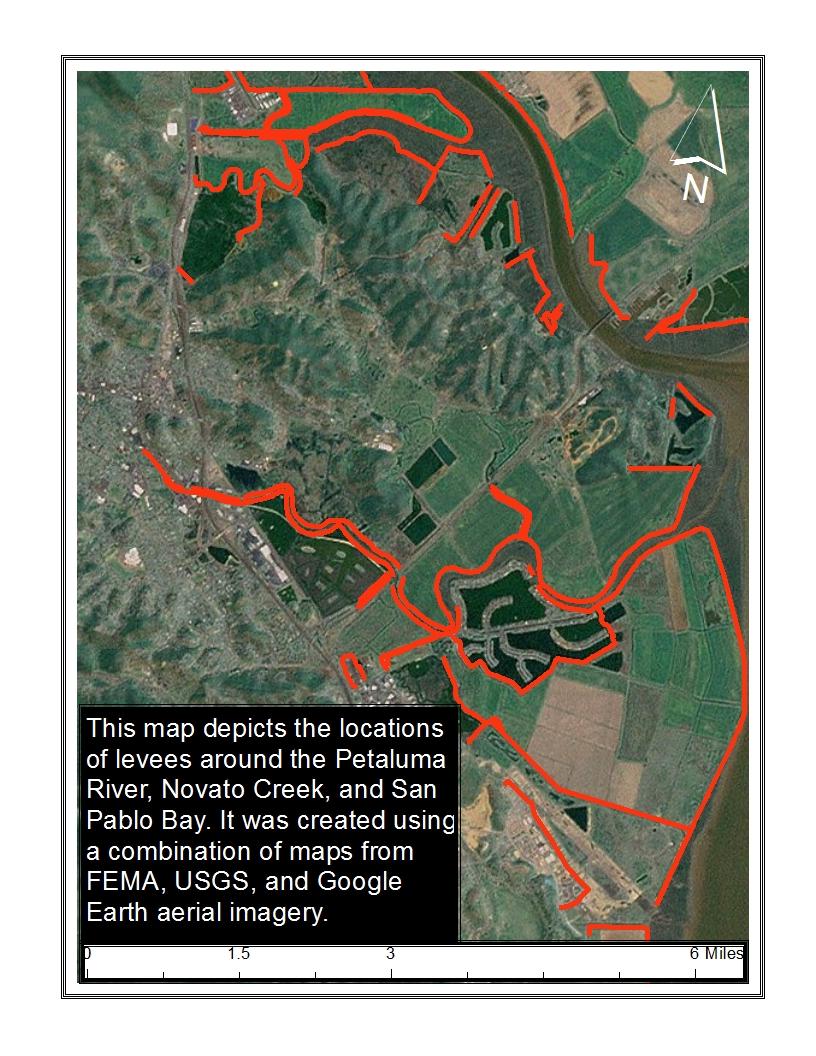
43 43


44 Appendix A Novato s Levees and Shorelines Section A: Rowland Plaza A.1 Rowland Plaza Conditions and Characteristics The levee network at this location guides Novato Creek past Rowland Plaza and Novato Community Hospital. Areas behind the levees areas are below sea level and are subject to regular flooding during high tides and heavy rain. According to the USGS, a 20inch rise in sea level would threaten the nearby shopping plaza and hospital, as well as the future SMART rail infrastructure and Highway


45 Appendix A Novato s Levees and Shorelines Section A: Vintage Oaks A.2 Vintage Oaks Conditions and Characteristics Protected by a one-mile long levee, Vintage Oaks at Novato is susceptible to a 20-inch rise in sea level according to the USGS. The SMART rail travels along the top of the levee behind the shopping plaza which would act as the first line of defense before an earthen berm that runs the length of the property. Threatened by sea level rise, this plaza is vulnerable on low-lying ground throughout the property. 45


46 Appendix A Novato s Levees and Shorelines Section A: Bahia A.3 Bahia Conditions and Characteristics The levee network at Bahia holds back the seasonal flooding of the Petaluma River, and is the only solid barrier protecting parts of the development from sea level rise. Recent restoration efforts have breached levees to allow for marsh lands to reestablish. Research suggests that the earlier tidal flows can be re-introduced, the sooner a property can return to tidal elevations and the more likely it will be able to remain resilient to future sea level rise by promoting future migration of wetlands inland as sea level rises. 46


47 Appendix A Novato s Levees and Shorelines Section A: Hamilton AFB A.4 Hamilton Conditions and Characteristics The low-lying areas behind the levee include properties that are up to two feet below sea level. An earth fill levee approximately 1.4 miles in length constructed in 1996 satisfies the minimum floodplain management criteria removing the properties behind the structure from the FEMA Special Flood Hazard Area. 47
48 Appendix B Vulnerable Buildings and Infrastructure 48


49 Appendix B Vulnerable Buildings and Infrastructure Section B. Highway 101 and Highway 37 Interchange B.1 Highway 101 and Highway 37 Conditions and Characteristics Situated in a lower-lying area, the Highway 101 and Highway 37 interchange would be vulnerable to a 20-inch rise in sea level with a 20-year annual flood according to the Our Coast, Our Future (OCOF) mapping tool (left). 49


50 Appendix B Vulnerable Buildings and Infrastructure Section B. Novato Sanitary District B.2 Novato Sanitary District Conditions and Characteristics Located in a low-lying area, the Sanitary District would be impacted by a 20-inch rise in sea level with a 20-year storm event according to OCOF maps (left). 50


51 Appendix B Vulnerable Infrastructure Section B. South Novato Electrical Substation B.3 PG&E Electrical Substation Conditions and Characteristics Located in an area prone to flooding the South Novato Electrical Station, a barrier was constructed around the substation in 1998 during a severe storm event to halt flooding. The substation is threatened by a 20-inch increase in sea level with a 20-year storm (left). 51
52 Appendix C Sea Level Rise Impacts on Selected Areas 52


53 Bahia: 20-inch Sea Level Rise with 20-year Storm Event Rowland Plaza: 20-inch Sea Level Rise with 20-Year Storm Event 53


54 Bel Marin Keys Industrial Park: 20-inch Sea Level Rise with 20-Year Storm Event Hamilton: 20-inch Sea Level Rise with 20-Year Storm 54
Adapting to Rising Tides
 Adapting to Rising Tides A regional program that uses findings, processes, tools and relationships built by ART and its partners to lead and support efforts that increase the resilience of San Francisco
CHAPTER 7. San Dieguito River Flooding Adaptation
 CHAPTER 7 San Dieguito River Flooding Adaptation This chapter includes a range of adaptation measures to address vulnerabilities from flooding along the San Dieguito River, including the river valley,
Climate Change Adaptation Strategies for Infrastructure Managers
 Climate Change Adaptation Strategies for Infrastructure Managers Green Streets and Highways Conference November 17, 2010 Butch Wlaschin Office of Asset Management Federal Highway Administration U.S. Department
ACKNOWLEDGEMENTS. Sincerely, Executive Director and Staff. Rockingham Planning Commission. 156 Water Street Exeter, NH (603)
") ACKNOWLEDGEMENTS The gratefully acknowledges the participation of coastal New Hampshire municipalities in the preparation of this report: City of Portsmouth Town of New Castle Town of Rye Town of North
ACKNOWLEDGEMENTS The gratefully acknowledges the participation of coastal New Hampshire municipalities in the preparation of this report: City of Portsmouth Town of New Castle Town of Rye Town of North
SECTION 6: MITIGATION STRATEGIES
 SECTION 6: MITIGATION STRATEGIES This section presents mitigation actions for Onondaga County to reduce potential exposure and losses identified as concerns in the Risk Assessment portion of this plan.
CITY OF PACIFICA 170 Santa Maria Avenue Pacifica, California
 CITY OF PACIFICA 170 Santa Maria Avenue Pacifica, California 94044-2506 www.cityofpacifica.org MAYOR Karen Ervin MAYOR PRO TEM Sue Digre Scenic Pacifica Incorporated Nov. 22, 1957 COUNCIL Mary Ann Nihart
The newly updated and comprehensive SWMP shall:
 RFQ SCOPE OF SERVICES 2.1 Project Purpose The City of Miami, ( City ) is seeking professional engineering services from a qualified firm for the purpose of planning and developing a newly updated and comprehensive
Adapting to Rising Tides. Contra Costa County Sea Level Rise Vulnerability Assessment
 Adapting to Rising Tides Contra Costa County Sea Level Rise Vulnerability Assessment Final Report February 2016 Acknowledgments CONSULTANT TEAM: Michael Mak, Julie Guyenet, Mark Lightner, Justin Vandever,
GUIDANCE FOR INCORPORATING SEA LEVEL RISE INTO CAPITAL PLANNING IN SAN FRANCISCO: ASSESSING VULNERABILITY AND RISK TO SUPPORT ADAPTATION
 GUIDANCE FOR INCORPORATING SEA LEVEL RISE INTO CAPITAL PLANNING IN SAN FRANCISCO: ASSESSING VULNERABILITY AND RISK TO SUPPORT ADAPTATION Prepared by the City and County of San Francisco Sea Level Rise
SAN FRANCISCO DISTRICT
 LETTER REPORT SAN FRANCISCO BAY SHORELINE STUDY U.S. ARMY CORPS OF ENGINEERS SAN FRANCISCO DISTRICT,APRIL 1992 LETTER REPORT SAN FRANCISCO BAY SHORELINE STUDY U.S. ARMY CORPS OF ENGINEERS SAN FRANCISCO
Overview of National and State erosion management reviews & reports
 Overview of National and State erosion management reviews & reports National Research Council: Managing Coastal Erosion 1990 Heinz Center: Evaluation of Erosion Hazards 2000 Maryland: Shore Erosion Task
SECTION 6: MITIGATION STRATEGY
 SECTION 6: MITIGATION STRATEGY This section describes the process by which the Lehigh Valley Steering Committee and municipal planning partnership performed the update to the county and local mitigation
Developing Evaluation Criteria
 ART SUPPLY: HOW-TO GUIDE Design Your Project Step 7: Evaluate Responses Developing Evaluation Criteria ADAPTING TO RISING TIDES PROGRAM This guide helps with Developing and using a set of criteria for
Intergovernmental Affairs and Communications Subcommittee. Initial recommendations for consideration by the Broward County Climate Change Task Force
 Intergovernmental Affairs and Communications Subcommittee Initial recommendations for consideration by the Broward County Climate Change Task Force September 17, 2009 The Intergovernmental Affairs and
Sea Level Rise Adaptation Strategy for San Diego Bay. Brian Holland, AICP, Climate Program Manager City of San Diego EESTF June 29, 2011
 Sea Level Rise Adaptation Strategy for San Diego Bay Brian Holland, AICP, Climate Program Manager City of San Diego EESTF June 29, 2011 Five Milestones for Climate Adaptation Adapted from Preparing for
STATE MAPPING BUSINESS PLAN OUTLINE
 STATE MAPPING BUSINESS PLAN OUTLINE good beginnings are not the measure of success. What matters in the end is completion. Performance. Results. Not just making promises, but making good on promises. George
Vulnerability Assessment
 Brief coastal vulnerability assessment for the City of Cocoa Beach, conducted utilizing available NOAA and UF GeoPlan tools. Vulnerability Assessment City of Cocoa Beach East Central Florida Regional Planning
Funding a More Holistic Effort - Bringing In New Partners and Resources Case Study: San Mateo County Shoreline Vulnerability Assessment
 Funding a More Holistic Effort - Bringing In New Partners and Resources Case Study: San Mateo County Shoreline Vulnerability Assessment Craig Conner Flood Risk Management Program Manager 3 December 2015
CHAPTER 11 Climate Change Considerations
 CHAPTER 11 CHAPTER 11 CLIMATE CHANGE CONSIDERATIONS 11.1 INTRODUCTION Human activities, such as energy production and land development also result in both direct and indirect emissions that contribute
PLEASE do not reuse without permission from NYCDEP. [Please notify Pinar Balci and Alan Cohn
 PLEASE do not reuse without permission from NYCDEP. [Please notify Pinar Balci (PBalci@dep.nyc.gov) and Alan Cohn (AlanC@dep.nyc.gov) if you intend to use any of these slides, and indicate where and when
CITY OF PORTSMOUTH, NEW HAMPSHIRE
 TIDES TO STORMS PREPARING FOR NEW HAMPSHIRE S FUTURE COAST Assessing Risk and Vulnerability of Coastal Communities to Sea Level Rise and Storm Surge Seabrook - Hampton Falls Hampton - North Hampton Rye
Natural Hazards Mitigation Plan Kankakee County, Illinois Executive Summary
 1. Introduction Natural Hazards Mitigation Plan Kankakee County, Illinois Executive Summary Kankakee County s first Natural Hazards Mitigation Plan was adopted by the Kankakee County Board on October 11,
Hydrology and Flooding
 Hydrology and Flooding Background The 1996 flood Between February 4, 1996 and February 9, 1996 the Nehalem reporting station received 28.9 inches of rain. Approximately 14 inches fell in one 48 hour period.
Transportation Vulnerability and Risk Assessment Pilot. American Planning Association Monday, April 16, 2012
 Transportation Vulnerability and Risk Assessment Pilot American Planning Association Monday, April 16, 2012 Goal The goal of Adapting to Rising Tides is to increase preparedness and resilience of Bay Area
Long term planning for NJ Coastal Resiliency: Coastal Flood Exposure Assessment and Salt Marsh Migration under future sea level rise
 Long term planning for NJ Coastal Resiliency: Coastal Flood Exposure Assessment and Salt Marsh Migration under future sea level rise Richard Lathrop, Lisa Auermuller, Jeanne Herb, Marjorie Kaplan, James
Climate Change Impact and Adaptation Assessment
 Climate Change Impact and Adaptation Assessment Projected warming (ºF) by NASA center, 2080s minus 1980s averaged across 16 GCMs under the A1B emissions scenario Cynthia Rosenzweig NASA Goddard Institute
Guidance for NEPA and SEPA Project-Level Climate Change Evaluations
 Guidance for NEPA and SEPA Project-Level Climate Change Evaluations Environmental Services Office November 2014 Update Introduction to the 2014 Version WSDOT s Environmental Services Office developed the
Revised 8-4. Board of Directors Water Planning and Stewardship Committee. September 11, 2007 Board Meeting. Subject. Description
 Board of Directors Water Planning and Stewardship Committee September 11, 2007 Board Meeting Subject Adopt criteria for conveyance options in implementation of Long Term Delta Plan Description Revised
State Route 37 Stewardship Study
 State Route 37 Stewardship Study Road Ecology Center, University of California, Davis Caltrans District 4 System Planning & Environmental Divisions Caltrans Headquarters Sonoma Land Trust, Sonoma Ecology
MECKLENBURG COUNTY HAZARD MITIGATION PLAN
 MECKLENBURG COUNTY HAZARD MITIGATION PLAN 2010 Plan Update Adopted By: Mecklenburg County City of Charlotte Town of Cornelius Town of Davidson Town of Huntersville Town of Matthews Town of Mint Hill Town
U.S. Army Corps of Engineers Broward County Planning Assistance to States. Flood Risk Management Study for Tidally Influenced Coastal Areas
 U.S. Army Corps of Engineers Broward County Planning Assistance to States Flood Risk Management Study for Tidally Influenced Coastal Areas Initial Stakeholder Resiliency Meeting Wednesday, November 9,
CITY OF MOUNTAIN VIEW
 CITY OF MOUNTAIN VIEW Incorporate Climate Change Adaptation in Municipal Scale, Urban Watershed Planning at the City of Mountain View Raymond Wong, PhD, PE, LEED AP Lisa Au, PE Floodplain Management Association
CHNEP/SWFRPC Climate Ready Programs
 CHNEP/SWFRPC Climate Ready Programs Southwest Florida is currently experiencing climate change. The natural setting of southwest Florida coupled with extensive overinvestment in the areas closest to the
8.2 How the Climate May Be Changing in Marin County
 Chapter 8 Climate Change Adaptation 8.1 Introduction Climate change planning includes at least two distinct response categories mitigation and adaptation. Mitigation refers to minimizing the magnitude
A State Policy Framework for Adaptation to Climate Change
 A State Policy Framework for Adaptation to Climate Change James Murley, Director Barry N. Heimlich Nick Bollman* Center for Urban and Environmental Solutions at Florida Atlantic University *In Memoriam
Chesapeake Bay TMDL 2017 Mid-Point Assessment
 Chesapeake Bay TMDL 2017 Mid-Point Assessment Guiding Principles and Options for Addressing Climate Change Considerations in the Jurisdictions Phase III Watershed Implementation Plans CBP Climate Resiliency
Creating a Resilient Community. The City of Satellite Beach Community Resiliency Project
 Creating a Resilient Community The City of Satellite Beach Community Resiliency Project Resources www.climate.gov www.climate.nasa.gov Agenda Creating A Resilient Community Project Overview Resiliency
Memorandum. FROM: Jim Ortbal Rosalynn Hughey Barry Ng TO: HONORABLE MAYOR, CITY COUNCIL. DATE: June 16, 2017
 CITY OF SANjOSE CAPITAL OF SILICON VALLEY TO: HONORABLE MAYOR, CITY COUNCIL SUBJECT: TRANSPORTATION POLICY UPDATE REQUIRED BY STATE LAW - LOS TO VMT Memorandum FROM: Jim Ortbal Rosalynn Hughey Barry Ng
Kane County Natural Hazards Mitigation Committee
 Kane County Natural Hazards Mitigation Committee Annual Report For 2004 TO: Members of the Kane County Board FROM: Kane County Natural Hazards Mitigation Committee SUBJECT: Annual Report for 2004 Date:
State of the Estuary Report 2015
 State of the Estuary Report 2015 Technical Appendix People Recycling Water Peter Vorster vorster@bay.org The Bay Institute TECHNICAL APPENDIX: RECYCLED WATER USE CONTEXT Most of the surface and ground
NOTICE OF PREPARATION
 NOTICE OF PREPARATION Date: June 12, 2014 To: From: Subject: Governor s Office of Planning and Research/State Clearinghouse Unit, Responsible Agencies, Trustee Agencies, and Interested Parties Announcement
CALIFORNIA COASTAL COMMISSION DRAFT SEA-LEVEL RISE POLICY GUIDANCE
 South Imperial Beach, TRNERR 1 CALIFORNIA COASTAL COMMISSION DRAFT SEA-LEVEL RISE POLICY GUIDANCE 17 September 2014 CMANC Fall 2014 Meeting Overview of Presentation 2 California and Coastal Act s Draft
Appendix D. San Francisco Bay Plan Consistency Analysis
 Appendix D San Francisco Bay Plan Consistency Analysis San Francisco Bay Plan Consistency Analysis Page 1 of 9 Protection of the Shoreline Policy 2: Riprap revetments, the most common shoreline protective
FEMA s Mitigation Support for Resiliency: Innovative Drought and Flood Mitigation Projects
 FEMA s Mitigation Support for Resiliency: Innovative Drought and Flood Mitigation Projects Jordan Williams, CFM Eric Kenney, PE, CFM May 4, 2017 2 Hazard Mitigation Purpose: Research climate resilient
Maryland Adaptation and Vulnerability Assessment Maryland State Highway Administration
 Maryland Adaptation and Vulnerability Assessment Maryland State Highway Administration October 4, 2016 Maryland: Introduction Atlantic Ocean and Chesapeake Bay 7,719 miles of shoreline Coastal in the East
Long-term Management Plan For The Mitigation Bank
 Note: The California multi-agency Project Delivery Team developed this general outline to assist in the development of the Long-term Management Plan for mitigation banks. Objectives and tasks are provided
SURREY COASTAL FLOOD ADAPTATION STRATEGY (CFAS) Improving Coastal Flood Adaptation Approaches (ICFAA) Stakeholder Workshop
 Improving Coastal Flood Adaptation Approaches (ICFAA) Stakeholder Workshop") SURREY COASTAL FLOOD ADAPTATION STRATEGY (CFAS) Improving Coastal Flood Adaptation Approaches (ICFAA) Stakeholder Workshop Workshop Introductions and Opening Remarks Our objectives for the day To explore
SURREY COASTAL FLOOD ADAPTATION STRATEGY (CFAS) Improving Coastal Flood Adaptation Approaches (ICFAA) Stakeholder Workshop Workshop Introductions and Opening Remarks Our objectives for the day To explore
A Salt Marsh Advancement Zone Assessment of West Haven, Connecticut
 A Salt Marsh Advancement Zone Assessment of West Haven, Connecticut Front cover image: Open space and unprotected parcels critical to the conservation of marsh advancement corridors in West Haven; from
CLIMATE CHANGE ADAPTATION IN MASSACHUSETTS
 CLIMATE CHANGE ADAPTATION IN MASSACHUSETTS Kathleen Baskin, Director of Water Policy June 3, 2013 MA Global Warming Solutions Act of 2008 Mitigation Reduce greenhouse gas emissions below 1990 levels by
Mitigation Plan Mission, Goals and Action Items
 Section 4: Mitigation Plan Mission, Goals and Action Items Introduction... 2 Mission... 2 Mitigation Plan Goals... 2 Natural Hazard Mitigation Plan Action Items... 3 Coordinating Organization... 4 Partner
Everglades Restoration Goals
 Everglades Restoration Goals Restore natural hydrologic conditions in the remaining 50% of historic Everglades Water quantity, quality, timing and distribution Maintain existing services in developed areas
7. NATURAL HAZARDS 7.1 SECTION INTRODUCTION
 7. NATURAL HAZARDS 7.1 SECTION INTRODUCTION 7.1.1 The Resource Management Act empowers Council to control any actual or potential effects of the use, development, or protection of land for the purpose
June 22, Francis E. Borcalli, P.E.
 CACHE CREEK SETTLING BASIN SYMPOSIUM Managing the Settling Basin Who s Doing What! June 22, 2009 Francis E. Borcalli, P.E. CACHE CREEK SETTLING BASIN SYMPOSIUM Managing the Settling Basin Who s Doing What!
2. Does not require, involve or include any additions to, or repair or modification of, the existing foundation.
 SECTION 3109 STRUCTURES SEAWARD OF A COASTAL CONSTRUCTION CONTROL LINE 3109.1 General. The provisions of this section shall apply to the design and construction of habitable structures, and substantial
Flooded Bus Barns and Buckled Rails: Public Transportation and Climate Change Adaptation
 Flooded Bus Barns and Buckled Rails: Public Transportation and Climate Change Adaptation Tina Hodges Federal Transit Administration September 22, 2011 Tina.Hodges@dot.gov 1 Key Themes Proactive instead
TREASURE COAST REGIONAL PLANNING COUNCIL M E M O R A N D U M. To: Council Members AGENDA ITEM 3E
 TREASURE COAST REGIONAL PLANNING COUNCIL M E M O R A N D U M To: Council Members AGENDA ITEM 3E From: Date: Subject: Staff May 19, 2017 Council Meeting Local Government Comprehensive Plan Review Draft
Session I: Introduction
 STAC Workshop M O N I T O R I N G A N D A S S E S S I N G I M P A C T S O F C H A N G E S I N W E A T H E R P A T T E R N S A N D E X T R E M E E V E N T S O N B M P S I T I N G A N D D E S I G N Session
Atlantic Coast of New York East Rockaway Inlet to Rockaway Inlet and Jamaica Bay, NY
 Atlantic Coast of New York East Rockaway Inlet to Rockaway Inlet and Jamaica Bay, NY Draft Reformulation Public Information October 2016 US Army Corps of Engineers Presentation Outline Project Overview
Port of Camas/Washougal Levee Recertification and Engineering Analysis Request for Proposal May 3, 2011
 I. Project Summary As part of their Map Modernization Program, FEMA has initiated a countywide Flood Insurance Study (FIS) and Digital Flood Insurance Rate Map (DFIRM) for the Port of Camas/Washougal.
Why a Regional Plan?
 Why a Regional Plan? Population Growth in the Golden State California grows by 300,000 500,000 people each year due mostly to new births and longer lifespans 700,000 600,000 500,000 400,000 300,000 200,000
Adapting to Rising Sea Level: A Florida Perspective
 Adapting to Rising Sea Level: A Florida Perspective Randall W. Parkinson RW Parkinson Consulting, Inc., 2018 Melbourne Ct., Suite 205, Melbourne, Florida 32901, USA Abstract. Global climate change and
Practical Needs and Approaches for Water Resources Adaptation to Climate Uncertainty
 Practical Needs and Approaches for Water Resources Adaptation to Climate Uncertainty Rolf Olsen, PhD Senior Lead, Climate Change Institute for Water Resources U.S. Army Corps of Engineers Alexandria, Virginia
Environment & Conservation Introduction
 Environment & Conservation Introduction Anacortes is blessed with an abundance of natural beauty. Residents identify marine shorelines, streams, lakes, forested areas, and other natural features as defining
PARSONS SLOUGH SILL PROJECT. Regulatory Compliance
 SUPPORTING MATERIALS PARSONS SLOUGH SILL PROJECT November 2009 Request for Proposals Contents Project Overview...2 Goals and Objectives... 2 Parsons Slough Restoration Project goals... 2 Ecologic goals
Vulnerabilities to Climate Change Impacts and Strengthening Disaster Risk Management in East Asian Cities
 2008 Primer Reducing Vulnerabilities to Climate Change Impacts and Strengthening Disaster Risk Management in East Asian Cities I/ CITY DESCRIPTION New York City comprises five boroughs, each of which is
Natural Breaks: A New Framework for Place-Based Sea Level Rise Adaptation in SF Bay
 Natural Breaks: A New Framework for Place-Based Sea Level Rise Adaptation in SF Bay Julie Beagle, SFEI, julieb@sfei.org Laura Tam, SPUR, lauraetam@gmail.com Many efforts are underway to assess the Bay
CHESAPEAKE BAY COMPREHENSIVE WATER RESOURCES AND RESTORATION PLAN. Habitat GIT Meeting 9 May 2017
 CHESAPEAKE BAY COMPREHENSIVE WATER RESOURCES AND 255 255 255 237 237 237 0 0 0 217 217 217 163 163 163 200 200 200 131 132 122 239 65 53 80 119 27 RESTORATION PLAN 110 135 120 252 174.59 112 92 56 62 102
IV. ENVIRONMENTAL IMPACT ANALYSIS G. HYDROLOGY/WATER QUALITY
 IV. ENVIRONMENTAL IMPACT ANALYSIS G. HYDROLOGY/WATER QUALITY ENVIRONMENTAL SETTING The project site is located in the Wilshire community of the City of Los Angeles and is bound by S. Wetherly Drive to
New Castle County, DE. Floodplain Regulations
 New Castle County, DE Floodplain Regulations John J. Gysling, PE CFM Department of Land Use New Castle County, DE February 26, 2009 Today s Presentation Floodplain Protection and Uses Terms and Definitions
Outcomes. Kelly Karll-SEMCOG Margaret Barondess - MDOT
 Eco-Logical: I-75 Corridor I-75 Conservation Transportation Action Planning in to Monroe Achieve County: Multiple Stormwater Environmental Considerations Outcomes Kelly Karll-SEMCOG Karll@semcog.org Margaret
Climate Change Impacts on Joint Riverine and Coastal Flooding on Calleguas Creek in Ventura County, CA
 Climate Change Impacts on Joint Riverine and Coastal Flooding on Calleguas Creek in Ventura County, CA James Gregory, James Jackson (ESA) Lily Verdone (TNC) FMA, September 8, 2016 Project Overview Coastal
10.1 Local Water Planning
 10 COORDINATION WITH EXISTING LOCAL/REGIONAL PLANS Each of the IRWM agencies plan and execute both short-term capital improvement programs and long-term plans and management programs. It is their plans,
Programmatic Environmental Impact Statement (EIS) for Lower Green River Corridor Plan Request for Proposals:
 for Lower Green River Corridor Plan Request for Proposals:") Programmatic Environmental Impact Statement (EIS) for Lower Green River Corridor Plan Request for Proposals: The King County Flood District (District) is seeking proposals from firms to prepare a programmatic
Programmatic Environmental Impact Statement (EIS) for Lower Green River Corridor Plan Request for Proposals: The King County Flood District (District) is seeking proposals from firms to prepare a programmatic
Introduction Page I-1 INTRODUCTION
 Introduction Page I-1 INTRODUCTION The Arcata General Plan: 2020 will help shape how the city of Arcata will look, function, provide services, and manage resources for the next 20 years. The plan is the
The Northern Waterfront Seawall History and Earthquake Performance Waterfront Plan Working Group Meeting April 13, 2016
 The Northern Waterfront Seawall History and Earthquake Performance Waterfront Plan Working Group Meeting April 13, 2016 Steven Reel, PE - Project Manager, Engineering Division, Port 1 The Northern Waterfront
II. CLIMATE CHANGE AND ADAPTATION
 II. CLIMATE CHANGE AND ADAPTATION Human beings have been adapting to the variable climate around them for centuries. Worldwide local climate variability can influence peoples decisions with consequences
Chapter 13: Wildlife and Vegetation
 Chapter 13: Wildlife and Vegetation Introduction and Setting Nevada County contains an extremely wide range of plants, animals and habitat types. With topographic elevations ranging from 300 feet in the
DAKOTA COUNTY SOIL AND WATER CONSERVATION DISTRICT COMPREHENSIVE PLAN
 DAKOTA COUNTY SOIL AND WATER CONSERVATION DISTRICT COMPREHENSIVE PLAN 2011-2015 4100 220 th Street West, Suite 102 Farmington, MN 55024 651-480-7777 www.dakotacountyswcd.org I. INTRODUCTION A. Purpose
COASTAL TX PROTECTION AND RESTORATION FEASIBILITY STUDY
 COASTAL TX PROTECTION AND RESTORATION FEASIBILITY STUDY Stakeholders Forum Dr. Kelly Burks-Copes, Project Manager Mr. Tony Williams, Coastal Resources US Army Corps of Engineers, Galveston District Texas
Climate Change Impacts of Most Concern for CB Agreement Goal & Outcome Attainment
 Climate Change Impacts of Most Concern for CB Agreement Goal & Outcome Attainment Zoë P. Johnson, Climate Change Coordinator Chesapeake Bay Program STAC Workshop March 7-8, 2016 Climate Change: Real Consequences
Climate Adaptation & California Native American Tribes
 Climate Adaptation & California Native American Tribes Contact Information Please call or email us if you d like us to walk through this information and if you have questions, comments, or concerns. For
Sea Level Rise: Impacts, Adaptation and Information Gaps
 University of New Orleans ScholarWorks@UNO Coastal Resilience Workshop Coastal Resilience Workshop 2015 Oct 28th, 10:00 AM - 12:00 PM Sea Level Rise: Impacts, Adaptation and Information Gaps Jeffrey R.
WATERSHED MANAGEMENT INITIATIVE: GOALS & IMPLEMENTATION OBJECTIVES, JULY 26, 1999
 WATERSHED MANAGEMENT INITIATIVE: GOALS & IMPLEMENTATION OBJECTIVES, JULY 26, 1999 The following table indicates the draft goals and objectives for the Santa Clara Basin WMI process. The overall objectives
SIZING UP CLIMATE RESILIENCE IN THE BAY AREA
 SIZING UP CLIMATE RESILIENCE IN THE BAY AREA A white paper by the Bay Area Joint Policy Committee and SPUR PUBLISHED JULY 24, 2014 With support from the San Francisco Foundation Primary authors: Laura
Water and Environment. Monterey Peninsula, Carmel Bay and South Monterey Bay Integrated Regional Water Management Draft Plan
 Water and Environment Monterey Peninsula, Carmel Bay and South Monterey Bay Integrated Regional Water Management Draft Plan December 11, 2006 Presentation Outline Purpose of IRWM Planning Status of Plan
Climate Change in the Northwest Territories. Heather Auld Adaptation and Impacts Research Section, Environment Canada
 Climate Change in the Northwest Territories Heather Auld Adaptation and Impacts Research Section, Environment Canada Climate Change means???? To Policy-Makers: Conventions, GHG reductions, regulations
King County, Washington Climate Change Adaptation Efforts
 King County, Washington Climate Change Adaptation Efforts Models for Adapting to Climate Change New Partners for Smart Growth Conference Seattle, WA, Feb. 4, 2010 Matt Kuharic (matt.kuharic@kingcounty.gov)
15A NCAC 07H.0209 COASTAL SHORELINES (a) Description. The Coastal Shorelines category includes estuarine shorelines and public trust shorelines.
 Description. The Coastal Shorelines category includes estuarine shorelines and public trust shorelines.") 15A NCAC 07H.0209 COASTAL SHORELINES (a) Description. The Coastal Shorelines category includes estuarine shorelines and public trust shorelines. Estuarine shorelines AEC are those non-ocean shorelines
15A NCAC 07H.0209 COASTAL SHORELINES (a) Description. The Coastal Shorelines category includes estuarine shorelines and public trust shorelines. Estuarine shorelines AEC are those non-ocean shorelines
Sea Level Rise in New York:
 Sea Level Rise in New York: Vulnerabilities and Methods of Analysis Westchester Municipal Planning Federation 2017 Land Use Training Institute April 5, 2017 Anjali Sauthoff What is Sea Level Rise? Image
Mississippi Coastal Improvements Program (MsCIP) Comprehensive Barrier Island Restoration Plan
 Comprehensive Barrier Island Restoration Plan") Mississippi Coastal Improvements Program (MsCIP) Comprehensive Barrier Island Restoration Plan BOEM Gulf of Mexico Sand Management Working Group October, 205 Justin McDonald, P.E. US Army Corps of Engineers
Mississippi Coastal Improvements Program (MsCIP) Comprehensive Barrier Island Restoration Plan BOEM Gulf of Mexico Sand Management Working Group October, 205 Justin McDonald, P.E. US Army Corps of Engineers
Sea-level Rise Science and Decision Making in an Uncertain Future. Rob Thieler U.S. Geological Survey Woods Hole, MA
 Sea-level Rise Science and Decision Making in an Uncertain Future Rob Thieler U.S. Geological Survey Woods Hole, MA Concepts Sea-level rise is one of the most certain impacts of climate change. There is
POLICY FOR NATURAL RESOURCE MANAGEMENT AREAS
 POLICY FOR NATURAL RESOURCE MANAGEMENT AREAS I. POLICY STATEMENT Auburn University's (the University's) "Policy for Natural Resource Management Areas" implements the Campus Master Plan Land Use Element
From: John D. Hines, P.E. Re: Old Dominion University Campus Master Plan Sea Level Rise Narrative
 Transportation Land Development Environmental S e r v i c e s Two Columbus Center 4500 Main Street, Suite 400 Virginia Beach, Virginia 23462 Telephone 757 490 0132 Fax 757 490 0136 Memorandum To: File
Case Study: Climate Change Adaptation in the City of Irvine, CA. ND-GAIN Urban Adaptation Assessment Gracie Georgi
 Case Study: Climate Change Adaptation in the City of Irvine, CA ND-GAIN Urban Adaptation Assessment Gracie Georgi 8.11.17 Author Gracie Georgi is a junior at the University of Notre Dame studying Political