Outcomes. Kelly Karll-SEMCOG Margaret Barondess - MDOT
|
|
|
- Jemimah Butler
- 6 years ago
- Views:
Transcription
1 Eco-Logical: I-75 Corridor I-75 Conservation Transportation Action Planning in to Monroe Achieve County: Multiple Stormwater Environmental Considerations Outcomes Kelly Karll-SEMCOG Margaret Barondess - MDOT BarondessM@michigan.gov

2 Project Overview FHWA SHRP2 Program Address landscape-level environmental priorities during planning 20 year complete reconstruction I-75 Monroe County, Michigan

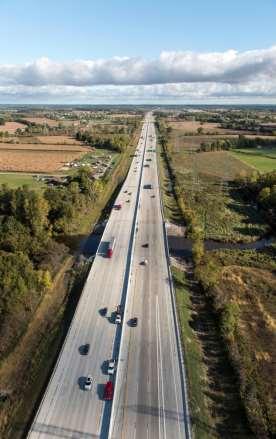
3 Monroe County, Michigan Corridor of Highest Significance Critical component of North American freight network International connection Ambassador bridge 40% of all trade with Canada transported through region 2.5 million truck trips per year 21%of all U.S. exports to Canada Opening of Gordie Howe Bridge

4 20 Year Reconstruction in Five Phases 20 year reconstruction of I-75 in 5 phases enables: Partnerships Data collection Consider environment Design Engineering Construction Align transportation plans with watershed plans Adaptive management Cost savings
5 Conservation Action Planning Identify Stakeholders & Create a Vision Develop Strategies & Objectives for Implementation I-75 Corridor Conservation Action Plan Select Geographic Scope & Conservation Targets Characterize Stressors Evaluate Viability of Targets & Establish Goals
6 Identify Stakeholders & Create a Vision Technical Advisory Committee Michigan Department of Transportation Michigan Natural Features Inventory Southeast Michigan Council of Governments Michigan Department of Natural Resources Michigan Department of Environmental Quality Michigan Department of Rural and Agricultural Development Michigan Sea Grant Federal Highway Administration The Nature Conservancy of Michigan Natural Resources Conservation Service US Army Corps of Engineers Monroe County U.S. Fish and Wildlife Service Local Implementation Partners Monroe County Road Commission Monroe County Drain Commission Monroe County Conservation District Monroe County Business Development Corporation City of Monroe Detroit River-Lake Erie Cooperative Weed Management Area Green Ribbon Initiative Southeast Michigan Land Conservancy Oak Openings Cooperative Weed Management Area The Nature Conservancy of Ohio Detroit River International Wildlife Refuge IHM Sisters

7 Vision Develop and implement a collaboratively based, landscape-scale conservation plan, that facilitates rebuilding the I-75 corridor while maximizing conservation and restoration outcomes in the region

8 Select Geographic Scope Geographic Scope Primary Zone: Defined by historic lake level fluctuation 575 ft. elevation contour US-24/ Historical Native American trail Secondary Zone: HUC-12 subwatersheds western boundary Northern boundary: Lower Huron River Watershed Water Resources were considered from the beginning!


9 Data collection for planning Landscape Level Functional Wetland Assessment (LLFWA) Water Quality Data Land Use/ Landcover Analysis Conservation Targets


10 Conservation Action Planning Process Identify Stakeholders & Create a Vision Develop Strategies & Objectives for Implementation I-75 Corridor Conservation Action Plan Characterize Stressors Select Geographic Scope & Conservation Targets Evaluate Viability of Targets & Establish Goals Conservation Targets: Coastal Tributaries - Fair Coastal Wetlands - Fair Migratory Fish - Good Herpetofauna Connectivity - Fair Globally Rare Natural Communities - Poor Aerial Migrants - Fair


11 Conservation Action Planning Process Identify Stakeholders & Create a Vision Top Stressors & Strategies: Agricultural Drainage and Runoff Develop Strategies & Objectives for Implementation I-75 Corridor Conservation Action Plan Select Geographic Scope & Conservation Targets Urban Development and Runoff Poorly Functioning Road Stream Crossings Invasive Species Characterize Stressors Evaluate Viability of Targets & Establish Goals

12 Strategies Agricultural Drainage and Runoff Priority Action: Develop a Smart Drain Assessment Project that incentivizes the implementation of Lake plain BMPs USDA Cropland

13 Strategies Urban Development & Runoff Priority Action: Create a new County initiative that takes an integrative approach to economic development and ecological enhancement Impervious land cover, I-75 at River Raisin


 in the I-75")
14 Strategies Invasive Species: Priority Action: Enhance the impact and capacity of existing Cooperative Weed Management Areas (CWMAs) in the I-75 Eco-Logical study area

15 Strategies Road Stream Crossings Priority Action: Conduct a comprehensive needs assessment for road stream crossings in the I-75 Eco-Logical study area
16 Implementation

17 MDOT Implementation Urban & Agricultural Runoff To manage runoff: Widened ditches to install BMPs Swales for water quality volume and conveyance Small infiltration component Check dams


18 MDOT Implementation Urban & Agricultural Runoff Estimated annual volume and pollutant reductions* Water quality volume: approx 1-inch over drainage area Runoff Volume: 24% reduction Total Phosphorous (TP): 44% reduction Total Suspended Solids (TSS): 58% reduction *Center for Watershed Protection Watershed Treatment Model


19 MDOT Implementation Wetland Mitigation Coastal wetland restoration Conversion of agricultural land to wetlands Considered opportunities for Hibernacula
20 MDOT Implementation Invasive Species MDOT joining local CWMA Creating management plan for I-75 corridor Prioritizing control locations Work with partners who seek access to ROW for treatment


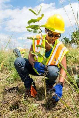
21 MDOT Implementation Native Plants Largest plant mitigation in MDOT history! 16,000 state-listed threatened plants in ROW Relocated 1,550 Sullivant s Milkweed to Sterling State Park Partnership with MDNR & Youth Corps
22 MDOT Implementation

23 MDOT Implementation Road Stream Crossings Monroe County has over 2,000 RSXs! Most miles of county drain in Michigan! Survey on culvert passability Established priorities for migratory fish


24 MDOT Implementation Herpetofauna Survey Evaluated connectivity Established priorities for Herpetofauna and wildlife


25 MDOT Implementation Improved Culvert Design Removal of Priority Flap Gates Extended Bridge Lengths Wildlife curbs and shelves Wildlife friendly erosion control Water Course Previous size or span length (1952) I-75 over Sandy Creek 30 feet 80 feet I-75 over Stony 130 feet 167 feet Creek I-75 over Miller and Malosh Drain B 6 feet 10 feet I-75 over Webb & Reisdorf Drain 8 feet 10 feet New size or span length (2016)


26 MDOT Implementation Benefits of improved culvert and bridge design: Reduces scour Reduces flooding Reduces velocity of flow


27 MDOT Implementation Considering Recreation Otter Creek Water Trail: Planned to reduce bridge clearance, but now increasing to accommodate water trail use! Added a bridge span and smaller beam to increase clearance Bridge Clearance: 8 11 to to 7 11

28 Migratory Fish Benefits Improving water quality helps migratory fish Western Banded Killifish Endangered in Ohio No listing in Michigan Orangethroat Darter Species of Concern in Michigan Northern Pike Spawn in low gradient, vegetated, smaller tributaries Benefit from removal of flap gates, increased culvert sizes

29 MDOT Implementation Public Education NOAA B-WET Grant Year 1: Piloting transportation and environment curriculum Topics: water quality, invasive species, etc. Monroe & Wayne County High School students creating interpretative material for MDOT Welcome Center Year 2: Training more teachers on curriculum

30 MDOT Implementation Cost Savings Saved $1,000,000 in land acquisition costs through MDNR partnership 50% Transplant Sullivant s milkweed to Sterling State Park 50% from constructing 34 acres of coastal wetlands at Erie State Game Area Partnership opened door for future MDOT/MDNR partnerships on wetland mitigation

31 Environment & Transportation Reconstruction continues Adaptive management Local implementation of Plan Water Resources Plan for Southeast Michigan Regional policies on stormwater & transportation Roads Action Team on Stormwater Discuss challenges related to managing road runoff Updating SEMCOG Long Range Transportation Plan Environmental Sensitivity Climate Resiliency


32 How else is SEMCOG Linking Watershed & Transportation Planning?

33 SEMCOG Long Range Transportation Plan SEMCOG 2045 Long Range Transportation Plan (LRP) Complete early 2019 Guides transportation investments in SE Michigan Improve quality and reliability pr transportation system to: Increase economic prosperity, Achieve fiscal sustainability Increase accessibility, Protect the environment Make communities desirable
34 Environmental Sensitivity Analysis Updating Environmental Sensitivity Analysis for 2045 LRP Identify potential impact of planned projects on natural resources Natural Resources Rivers, Lakes and Streams Designated Trout Lakes/Streams & Natural Rivers TMDLs Location in watershed T & E species Wetlands Floodplains Parks and Recreation Historic Sites & Heritage Routes Cemeteries
35 Water Resources Plan for Southeast Michigan DRAFT TRANSPORTATION POLICY #1: Support coordinated efforts to align water, natural resources and transportation priorities. ACTIONS: a. Enhance environmental considerations within the regional transportation planning process. b. Utilize the environmental sensitivity analysis to inform transportation agencies of potential impacts. c. Support and facilitate collaboration between road agencies and local jurisdictions regarding stormwater management opportunities that work towards water quality standards.
36 Water Resources Plan for Southeast Michigan TRANSPORTATION POLICY #2: Integrate multiple outcomes, including mobility, recreation and habitat, into road stream crossing and culvert designs. ACTIONS: a. Inventory and conduct condition assessments of road stream crossings. b. Categorize road stream crossings and prioritize improvements for multiple transportation modes, water trails, streamflow condition and fish migration. c. Evaluate adaptive capacity of high priority road stream crossings.
37 Eco-Logical: I-75 Corridor I-75 Conservation Transportation Action Planning in to Monroe Achieve County: Multiple Stormwater Environmental Considerations Outcomes Kelly Karll-SEMCOG Margaret Barondess - MDOT BarondessM@michigan.gov
Habitat Grant Projects Clinton River Watershed
 Habitat Grant Projects Clinton River Watershed L Y N N E S E Y M O U R E N V I R O N M E N T A L E N G I N E E R O F F I C E O F T H E M A C O M B C O U N T Y P U B L I C W O R K S C O M M I S S I O N
Municipal Stormwater Management Planning
 Municipal Stormwater Management Planning Christopher C. Obropta, Ph.D., P.E. Water Resources Extension Specialist with Rutgers Cooperative Extension Assistant Professor with Department of Environmental
Regional Watershed Planning. Calumet Summit 2010: A Call to Connect Calumet Conference Center April 27, 2010
 Regional Watershed Planning Calumet Summit 2010: A Call to Connect Calumet Conference Center April 27, 2010 Basins The Calumet Region Watershed Communities Land Cover- 2006 Impervious Cover 303d Listed
CHESAPEAKE BAY COMPREHENSIVE WATER RESOURCES AND RESTORATION PLAN. Habitat GIT Meeting 9 May 2017
 CHESAPEAKE BAY COMPREHENSIVE WATER RESOURCES AND 255 255 255 237 237 237 0 0 0 217 217 217 163 163 163 200 200 200 131 132 122 239 65 53 80 119 27 RESTORATION PLAN 110 135 120 252 174.59 112 92 56 62 102
COON CREEK WATERSHED DISTRICT PERMIT REVIEW. Spring Lake Park Schools Westwood Middle School st Avenue NE, Spring Lake Park, MN 55432
 PAN 16-112, Westwood Middle School, Page 1 of 6 COON CREEK WATERSHED DISTRICT PERMIT REVIEW MEETING DATE: August 22, 2016 AGENDA NUMBER: 10 FILE NUMBER: 16-112 ITEM: Westwood Middle School RECOMMENDATION:
TORCH LAKE TOWNSHIP WATER QUALITY ACTION PLAN
 TORCH LAKE TOWNSHIP WATER QUALITY ACTION PLAN Elk-River-Chain-of-Lakes Gaps Analysis Project The Watershed Center Grand Traverse Bay Tip of the Mitt Watershed Council Michigan Department of Natural Resources
A Summary Guide to the. Rifle River WATERSHED MANAGEMENT PLAN. Know Your Watershed Protect Its Resources
 A Summary Guide to the Rifle River WATERSHED MANAGEMENT PLAN Know Your Watershed Protect Its Resources Table of Contents The Watershed... 3 The Management Plan... 4 Designated and Desired Uses... 5 Sources
Water and Watersheds. Data Maps Action
 Water and Watersheds Data Maps Action What is the Wildlife Action Plan? Restore rare wildlife and habitats. Keep common species common. 2015 Revision: Partners in Conservation Science 2015 Revision Data
STREAM RESTORATION PURPOSE, PRACTICE, AND METHODS. By Marcus Rubenstein, CPESC
 STREAM RESTORATION PURPOSE, PRACTICE, AND METHODS By Marcus Rubenstein, CPESC WHAT IS STREAM RESTORATION? The return of a stream s lost natural functions, usually resulting from watershed alterations,
719 Griswold, Suite 820 Detroit, MI DANVERS POND DAM REMOVAL AND STREAM RESTORATION PROJECT
 Great Lakes Restoration Initiative Grant Final Report US EPA Grant GL 00E006 43 October, 2013 Valley Woods Wetland Southfield Lola Valley Grow Zone Wayne County Parks Venoy Park Grow Zone Wayne County
DAKOTA COUNTY SOIL AND WATER CONSERVATION DISTRICT COMPREHENSIVE PLAN
 DAKOTA COUNTY SOIL AND WATER CONSERVATION DISTRICT COMPREHENSIVE PLAN 2011-2015 4100 220 th Street West, Suite 102 Farmington, MN 55024 651-480-7777 www.dakotacountyswcd.org I. INTRODUCTION A. Purpose
The total population of the township is 9,942 (2015 Five-Year American Community Survey [ACS]). The median household income is over $109,000.
![The total population of the township is 9,942 (2015 Five-Year American Community Survey [ACS]). The median household income is over $109,000.](/thumbs/72/67990406.jpg "The total population of the township is 9,942 (2015 Five-Year American Community Survey [ACS]). The median household income is over $109,000.") East Bradford Township, Pennsylvania Motivated by watershed impairment caused by suburban development over the past 30 years, a township with a full slate of water quality improvement programs looks outside
East Bradford Township, Pennsylvania Motivated by watershed impairment caused by suburban development over the past 30 years, a township with a full slate of water quality improvement programs looks outside
Chapter 10 Natural Environment
 Chapter 10 Natural Environment Existing Conditions The Natural Environment Element addresses the protection, conservation, preservation, and restoration of the natural resources the Bayview Ridge Subarea,
EFFECT OF UPSTREAM DEVELOPMENT ON THE CLEAR CREEK AREA
 EFFECT OF UPSTREAM DEVELOPMENT ON THE CLEAR CREEK AREA Technical Memorandum Farming in the Floodplain Project Prepared for May 2017 PCC Farmland Trust Photo credit: Google Earth TABLE OF CONTENTS Page
Nutrient Management in. A presentation to the West Metro Water Alliance
 Nutrient Management in Developing and Agricultural Areas A presentation to the West Metro Water Alliance Chris Meehan, P.E. May 25, 2011 Agenda Physical Improvements Planning Improvements How to get it
Hydrologic and Ecologic Impacts from the CERP Indian River Lagoon South Project
 Hydrologic and Ecologic Impacts from the CERP Indian River Lagoon South Project Dr. Gretchen Ehlinger Senior Biologist US Army Corps of Engineers Jacksonville District November 15, 2016 AWRA Conference
Chapter 13: Wildlife and Vegetation
 Chapter 13: Wildlife and Vegetation Introduction and Setting Nevada County contains an extremely wide range of plants, animals and habitat types. With topographic elevations ranging from 300 feet in the
VILLAGE OF BELLAIRE WATER QUALITY ACTION PLAN
 VILLAGE OF BELLAIRE WATER QUALITY ACTION PLAN Elk-River-Chain-of-Lakes Gaps Analysis Project The Watershed Center Grand Traverse Bay Tip of the Mitt Watershed Council Michigan Department of Natural Resources
Chapter 3 Affected Environment and Environmental Consequences
 Sterling Highway MP 45 60 Draft SEIS and Draft Section 4(f) Evaluation Chapter 3 Affected Environment and Environmental Consequences Prepared for: Alaska Department of Transportation and Public Facilities
BIG ROCHE A CRI LAKE CHARACTERISTICS
 BIG ROCHE A CRI LAKE CHARACTERISTICS Lake Description Big Roche Cri Lake is located in north central Adams County and has a surface area of 205 acres, a shoreline length of 6.1 mile, a volume of 6,993
Wisconsin Wastewater Operators Association. Protecting Our Water Resources: The Future Bill Hafs - NEW Water 10/2014
 Wisconsin Wastewater Operators Association Protecting Our Water Resources: The Future Bill Hafs - NEW Water 10/2014 The Fox River Contributes 1/3 of All Nutrients to Lake Michigan APRIL 15, 2011 Photo
 Good Morning! Bruce Gilman Department of Environmental Conservation and Horticulture Finger Lakes Community College 3325 Marvin Sands Drive Canandaigua, New York 14424 585-785- 1255 gilmanba@flcc.edu Northern
Environmental Information Worksheet
 Environmental Information Worksheet Water System Owner (Attach additional sheets if necessary) Needs and Alternatives Provide a brief narrative that describes: Current drinking water system needs. Project
SECTION 3 NATURAL RESOURCES
 SECTION 3 NATURAL RESOURCES The natural environment plays a large role in planning for future development. Environmental conditions, such as topography, wetlands, floodplains, and water bodies, can often
APPENDIX H Guidance for Preparing/Reviewing CEQA Initial Studies and Environmental Impact Reports
 APPENDIX H H.1 Guidance for Preparing and Reviewing CEQA Initial Studies Step 1: Consider the Project Characteristics as Provided by the Project Applicant Review the project application and draft plan
King County Flood Control District approves grants for flood prevention projects Regional projects to benefit from district funds
 News Release Contact: Al Sanders 206-477-1016 August 31, 2015 Flood Control District approves grants for flood prevention projects Regional projects to benefit from district funds The Flood Control District
All driveways shall have a separate site plan when the application is submitted.
 Driveway Submittal Requirements All driveways shall have a separate site plan when the application is submitted. Within 24 hours of application submittal, all proposed driveways shall: be addressed with
FEMA s Mitigation Support for Resiliency: Innovative Drought and Flood Mitigation Projects
 FEMA s Mitigation Support for Resiliency: Innovative Drought and Flood Mitigation Projects Jordan Williams, CFM Eric Kenney, PE, CFM May 4, 2017 2 Hazard Mitigation Purpose: Research climate resilient
Crow s Foot Conservation Area Feasibility Study
 Crow s Foot Conservation Area Feasibility Study Site Opportunities Presentation Trust For Public Land PRESENTED BY SmithGroup JJR August, 2002 McHenry County Conservation District Boone County Conservation
Trails Permitting Process
 Appendix H: Trail Permitting Process A PPENDIX H: T RAIL P ERMITTING P ROCESS Trails Permitting Process The permitting process is a critical component in the successful development of a trail network.
Doyle Park Reconstruction Project Improving Flood Control Facilities to Meet a TMDL
 Doyle Park Reconstruction Project Improving Flood Control Facilities to Meet a TMDL Ann Arbor, Michigan Washtenaw County Drain Commissioner & Malletts Creek Coordinating Committee November, 2007 Janis
Chapter 11 Culverts and Bridges
 Chapter 11 Culverts and Bridges Contents 1.0 Introduction... 1 2.0 General Design... 1 2.1 Design Criteria... 1 2.2 Design Flows... 1 2.3 Permitting and Regulations... 1 2.4 Aesthetics and Safety... 2
General Plan Update Workshop 6 Agriculture, Conservation, & Open Space February 23, 2005
 General Plan Update Workshop 6 Agriculture, Conservation, & Open Space February 23, 2005 Municipal Services Agency Planning and Community Development Department Workshop Outline GPU Update Background &
Holly Swartz and Jason Shirey
 Chapter 105 General Permits for Stream and Wetland Impacts DEP Ch. 105 CONTACTS FOR BERKS COUNTY: Holly Swartz and Jason Shirey What DEP Regulates Under Chapter 105 Waters of the Commonwealth, which includes
Appendix 12. Pollutant Load Estimates and Reductions
 Appendix 12. Pollutant Load Estimates and Reductions A pollutant loading is a quantifiable amount of pollution that is being delivered to a water body. Pollutant load reductions can be calculated based
RURAL RESIDENTIAL COMMUNITY ROLE COUNCIL ROLE RURAL RESIDENTIAL ALL COMMUNITIES
 Orderly and Efficient Land Use Align land use, development patterns, and infrastructure to make the best use of public and private investment. Discourage future development of rural residential patterns
Department of the Army Permit Application
 Department of the Army Permit Application DA File Number U.S. Army Corps of Engineers Honolulu District Date Received by CEPOH-RO Send Completed Application to: Honolulu District, U.S. Army Corps of Engineers
Project Goals and Scoping
 Prepared for: Boulder County, Colorado Flood Planning & Preliminary Design Services for South St. Vrain Creek Restoration at Hall Ranch and Scoping May 24, 2016 Meeting with General Public In association
Climate Change Adaptation Strategies for Infrastructure Managers
 Climate Change Adaptation Strategies for Infrastructure Managers Green Streets and Highways Conference November 17, 2010 Butch Wlaschin Office of Asset Management Federal Highway Administration U.S. Department
Polluted Runoff and Land Conservation: What s the Connection?
 Polluted Runoff and Land Conservation: What s the Connection? Caroly Shumway, Ph.D. Executive Director, Merrimack River Watershed Council In partnership with NMCOG Overview Purpose Of This Talk Is To Convey
Information for File # PRH
 Information for File # 2016-02602-PRH Applicant Corps Contact Tom Morley Paul Hauser Address 152 Baker Drive, Redwood Falls, MN 56283 E-Mail Paul.R.Hauser@usace.army.mil Phone 651-290-5357 Primary County
Acres within Planning Area. Total Acres Burned
 Calf-Copeland Project Description Figure 1: Dead sugar pine in the Calf-Copeland planning area. Sugar pine grow best in open conditions. In the absence of fire disturbance, high densities of Douglas-fir
Georgia's Nonpoint Source Management Program. Linda MacGregor Watershed Protection Branch Georgia Environmental Protection Division
 Georgia's Nonpoint Source Linda MacGregor Watershed Protection Branch Georgia Environmental Protection Division Overview of Georgia s Nonpoint Source Georgia s s Nonpoint Source is a comprehensive framework
https://orm.usace.army.mil/orm2/f?p=106:34: ::no::
 Page 1 of 7 APPROVED JURISDICTIONAL DETERMINATION FORM U.S. Army Corps of Engineers SECTION I: BACKGROUND INFORMATION A. REPORT COMPLETION DATE FOR APPROVED JURISDICTIONAL DETERMINATION (JD): 26-Dec-2013
Stormwater Management Studies PDS Engineering Services Division ES Policy # 3-01
 Stormwater Management Studies PDS Engineering Services Division Revised Date: 2/28/08 INTRODUCTION The City of Overland Park requires submission of a stormwater management study as part of the development
DESIGN BULLETIN #16/2003 (Revised July 2007) Drainage Guidelines for Highways Under Provincial Jurisdiction in Urban Areas.
 Drainage Guidelines for Highways Under Provincial Jurisdiction in Urban Areas.") Drainage Guidelines for Highways Under Provincial Jurisdiction in Urban Areas. July 2007 Update to Design Bulletin #16/2003: Added under Design Criteria Culverts of 600mm diameter are commonly used to
Drainage Guidelines for Highways Under Provincial Jurisdiction in Urban Areas. July 2007 Update to Design Bulletin #16/2003: Added under Design Criteria Culverts of 600mm diameter are commonly used to
NEW CASTLE CONSERVATION DISTRICT. through. (Name of Municipality) PLAN REVIEW APPLICATION DRAINAGE, STORMWATER MANAGEMENT, EROSION & SEDIMENT CONTROL
 PLAN REVIEW APPLICATION DRAINAGE, STORMWATER MANAGEMENT, EROSION & SEDIMENT CONTROL") NEW CASTLE CONSERVATION DISTRICT through (Name of Municipality) PLAN REVIEW APPLICATION DRAINAGE, STORMWATER MANAGEMENT, EROSION & SEDIMENT CONTROL Office use only: Received by Municipality: Received by
NEW CASTLE CONSERVATION DISTRICT through (Name of Municipality) PLAN REVIEW APPLICATION DRAINAGE, STORMWATER MANAGEMENT, EROSION & SEDIMENT CONTROL Office use only: Received by Municipality: Received by
CHAPTER 7. San Dieguito River Flooding Adaptation
 CHAPTER 7 San Dieguito River Flooding Adaptation This chapter includes a range of adaptation measures to address vulnerabilities from flooding along the San Dieguito River, including the river valley,
Council of Governments
 Metropolitan Washington Council of Governments Anne Arundel County Draft Phase II Watershed Implementation Plan January 18, 2011 Chesapeake Bay TMDL Pollutants of Concern Nitrogen Phosphorus Sediment 2
Location Drainage Study
 Location Drainage Study PROJECT ROUTE: LIMITS: MUNICIPALITY/COUNTY: JOB NUMBER: IL 47 at Burlington Road 750ft NW to 750ft SE of IL 47(Burlington), & 1000ft S to 1000ft N of Burlington (IL47) Kane County
Natural Resources and Climate Resiliency in Germantown
 Natural Resources and Climate Resiliency in Germantown Ingrid Haeckel, Andrew Meyer, and Elizabeth Murphy NYSDEC Hudson River Estuary Program and Cornell University Presentation to the Town of Germantown,
6.0 Runoff. 6.1 Introduction. 6.2 Flood Control Design Runoff
 October 2003, Revised February 2005 Chapter 6.0, Runoff Page 1 6.1 Introduction 6.0 Runoff The timing, peak rates of discharge, and volume of stormwater runoff are the primary considerations in the design
Constructed Wetland Pond T-8
 Constructed Wetland Pond T-8 Description A constructed wetlands pond is a shallow retention pond designed to permit the growth of wetland plants such as rushes, willows, and cattails. Constructed wetlands
PUBLIC NOTICE. Section 404 of the Clean Water Act (33 U.S.C. 1344) Section 10 of the Rivers and Harbors Act of 1899 (33 U.S.C.
 Section 10 of the Rivers and Harbors Act of 1899 (33 U.S.C.") US Army Corps Of Engineers Wilmington District PUBLIC NOTICE Issue Date: June 17, 2014 Comment Deadline: July 17, 2014 Corps Action ID#: SAW-2009-00655 NC DOT TIP: R-4903 The Wilmington District, Corps
US Army Corps Of Engineers Wilmington District PUBLIC NOTICE Issue Date: June 17, 2014 Comment Deadline: July 17, 2014 Corps Action ID#: SAW-2009-00655 NC DOT TIP: R-4903 The Wilmington District, Corps
FREQUENTLY ASKED QUESTIONS: URBAN STREAM RESTORATION BMP. David Wood Chesapeake Stormwater Network. Lisa Fraley-McNeal Center for Watershed Protection
 FREQUENTLY ASKED QUESTIONS: David Wood Chesapeake Stormwater Network URBAN STREAM RESTORATION BMP Lisa Fraley-McNeal Center for Watershed Protection Bill Stack Center for Watershed Protection FREQUENTLY
POLICY FOR NATURAL RESOURCE MANAGEMENT AREAS
 POLICY FOR NATURAL RESOURCE MANAGEMENT AREAS I. POLICY STATEMENT Auburn University's (the University's) "Policy for Natural Resource Management Areas" implements the Campus Master Plan Land Use Element
5 th National Conference on Ecosystem Restoration. Alliance for the Great Lakes. Policy & Partnership for Ecosystem Restoration
 5 th National Conference on Ecosystem Restoration Policy & Partnership for Ecosystem Restoration Alliance for the Great Lakes Angela Larsen Coastal Program Manager, Lake Michigan Watershed Ecosystem Partnership
POND SITING REPORT TABLE OF CONTENTS LIST OF TABLES LIST OF FIGURES EXECUTIVE SUMMARY SECTION 1.0 INTRODUCTION SECTION 2.0 PROJECT DESCRIPTION
 November, 2014 TABLE OF CONTENTS LIST OF TABLES LIST OF FIGURES EXECUTIVE SUMMARY POND SITING REPORT Summary of section 1.0 & 2.0. Specify datum used in the design calculations and the construction plans.
L-THIA Online and LID in a watershed investigation
 L-THIA Online and LID in a watershed investigation Larry Theller Agricultural and Biological Engineering, Purdue University Great Lakes Sedimentation Workshop Ann Arbor Mi. L-THIA On-line watershed delineation
C O M P R E H E N S I V E P R O T E C T I O N & R E S T O R AT I O N P L A N. f or th e
 C O M P R E H E N S I V E P R O T E C T I O N & R E S T O R AT I O N P L A N f or th e R O S S B A R NE T T R E SERV O I R WATERS HED, MI S S I S S I P P I E X E C U T I V E S U M M A R Y O C T O B E R
Oregon Department of State Lands. Protecting Natural and Fiscal Resources to Support Schools
 Oregon Department of State Lands Protecting Natural and Fiscal Resources to Support Schools Heidi Hartman Jefferson, Hood River, Sherman, Wasco, Morrow, Gilliam, Union, Baker, Grant, Wallowa, Umatilla,
SW-74 SERENOVA PRESERVE SITES 2, 3, 4, 8 MITIGATION PLAN
 SW-74 SERENOVA PRESERVE SITES 2, 3, 4, 8 MITIGATION PLAN BACKGROUND INFORMATION Project SWIM? Aquatic Control? Exotic Control? Mitigation Bank? Type No No No No Mitigation Restoration and enhancement Type
Stormwater Local Design Manual For Houston County, Georgia
 Stormwater Local Design Manual For Houston County, Georgia Adopted November 15, 2005 TABLE OF CONTENTS 1. FORWARD... 1 2. GENERAL LEVEL OF SERVICE STANDARDS... 2 2.1. DETENTION REQUIREMENTS... 2 2.1.1.
New Castle County, DE. Floodplain Regulations
 New Castle County, DE Floodplain Regulations John J. Gysling, PE CFM Department of Land Use New Castle County, DE February 26, 2009 Today s Presentation Floodplain Protection and Uses Terms and Definitions
Raritan River Basin. How to protect quality & quantity of water resources? Land Protection and Management to Protect Water Resources
 Land Protection and Management to Protect Water Resources New Jersey Water Supply Authority: Kathy Hale, Principal Watershed Protection Specialist (908) 685-0315 x228 khale@raritanbasin.org Jen Zhang,
EAST TORRANCE SOIL AND WATER CONSERVATION DISTRICT. LONG RANGE PLAN July 1, 2009 June 30, 2019
 EAST TORRANCE SOIL AND WATER CONSERVATION DISTRICT LONG RANGE PLAN July 1, 2009 June 30, 2019 INTRODUCTION The East Torrance Soil and Water Conservation District covers 1,142,028 acres of land in Torrance
S.O.P. No. HMD
 Page: 1 of 9 PURPOSE: To establish (SOP) for submission requirements, review process and approval of applications for Non-vehicular Access Permits for the purpose of connection or discharge to any MassDOT
DRAFT GREATER MOOSES TOOTH TWO (GMT2) DEVELOPMENT PROJECT PERMITTEE RESPONSIBLE WETLANDS MITIGATION PLAN NATIONAL PETROLEUM RESERVE-ALASKA
 DEVELOPMENT PROJECT PERMITTEE RESPONSIBLE WETLANDS MITIGATION PLAN NATIONAL PETROLEUM RESERVE-ALASKA") DRAFT GREATER MOOSES TOOTH TWO (GMT2) DEVELOPMENT PROJECT PERMITTEE RESPONSIBLE WETLANDS MITIGATION PLAN NATIONAL PETROLEUM RESERVE-ALASKA Prepared for: ConocoPhillips Alaska, Inc. Anchorage, AK March
DRAFT GREATER MOOSES TOOTH TWO (GMT2) DEVELOPMENT PROJECT PERMITTEE RESPONSIBLE WETLANDS MITIGATION PLAN NATIONAL PETROLEUM RESERVE-ALASKA Prepared for: ConocoPhillips Alaska, Inc. Anchorage, AK March
Public Notice. Applicant: City of Dallas Project No.: SWF Date: April 18, Name: Chandler Peter Phone Number:
 Public Notice Applicant: City of Dallas Project No.: SWF- 2014-00151 Date: April 18, 2014 The purpose of this public notice is to inform you of a proposal for work in which you might be interested. It
Local Flood Hazard Mitigation Program. A framework for hazard mitigation in the NYC West of Hudson Water Supply Watersheds
 Local Flood Hazard Mitigation Program A framework for hazard mitigation in the NYC West of Hudson Water Supply Watersheds Flood Hazard Mitigation Defined 2 2 Presentation Overview Why and how is the NYC
Comfort Lake-Forest Lake Watershed District Six Lakes Total Maximum Daily Load Implementation Plan
 Prepared by: for the Comfort Lake-Forest Lake Watershed District and the Minnesota Pollution Control Agency Comfort Lake-Forest Lake Watershed District Six Lakes Total Maximum Daily Load February 16, 2010
UMD Storm Water Program Construction Requirements. Greg Archer, MBA Environmental Compliance Specialist
 UMD Storm Water Program Construction Requirements Greg Archer, MBA Environmental Compliance Specialist Phase 2 Regulatory Overview Dec. 1999 EPA issues Phase 2 Federal Register Municipalities (MS4) from
MODEL Stormwater Local Design Manual. City of Centerville
 MODEL Stormwater Local Design Manual City of Centerville Adopted December 6, 2005 TABLE OF CONTENTS 1. FORWARD... 1 2. GENERAL LEVEL OF SERVICE STANDARDS... 1 2.1. DETENTION REQUIREMENTS... 1 2.1.1. Discharge
CRJC Mount Ascutney Local River Subcommittee
 CRJC Mount Ascutney Local River Subcommittee Tuesday, November 15, 2016 Windsor Welcome Center 3 Railroad Ave, Windsor Vermont DRAFT MINUTES Present: John Bruno, Charlestown Cordie Merritt, Hartland Judy
The project will be conducted in partnership with the Nez Perce Tribe.
 DECISION MEMO Tributary to Brushy Fork Culvert Replacements Private Land USDA Forest Service, Northern Region Powell Ranger District Nez Perce Clearwater National Forests Idaho County, Idaho I. Decision
E. STORMWATER MANAGEMENT
 E. STORMWATER MANAGEMENT 1. Existing Conditions The Project Site is located within the Lower Hudson Watershed. According to the New York State Department of Environmental Conservation (NYSDEC), Lower Hudson
West Branch LeClerc Creek Watershed Restoration Project Environmental Assessment
 West Branch LeClerc Creek Watershed Restoration Project Environmental Assessment Decision Notice, Finding of No Significant Impact, and Response to Public Comments April 2015 USDA Forest Service Colville
Walnut Creek Watershed Management Authority. Project Kick Off March 18, 2015
 Walnut Creek Watershed Management Authority Project Kick Off March 18, 2015 Agenda Schedule & Meeting Purpose Meeting Purpose TMDL Raccoon River TMDL Impaired by Nitrate and E.coli Includes Walnut Creek
BOONE COUNTY COMPREHENSIVE STORMWATER MANAGEMENT PLAN
 BOONE COUNTY COMPREHENSIVE STORMWATER MANAGEMENT PLAN Approved by the Boone County Stormwater Committee September 23, 2010 Approved by the Boone County Board December 21, 2011 Prepared for: Boone County
Integrating Water Quality and Natural Filters into Maryland s Marine Spatial Planning Efforts
 Integrating Water Quality and Natural Filters into Maryland s Marine Spatial Planning Efforts Nicole Carlozo NOAA Coastal Management Fellow July 31, 2014 Watershed-scale restoration targeting helps direct
NIAGARA RIVER WATERSHED MANAGEMENT PLAN (Phase 1) Buffalo Sewer Authority (BSA), Long Term Control Plan, Buffalo: BSA, 2012
 Buffalo Sewer Authority (BSA), Long Term Control Plan, Buffalo: BSA, 2012") Bibliography Alden, M., Mortsch, L., Sheraga, J., Climate Change & Water Quality in the Great Lakes Region: Risks, Opportunities & Responses. Detroit: Report of the Great Lakes Water Quality Board to the
Bibliography Alden, M., Mortsch, L., Sheraga, J., Climate Change & Water Quality in the Great Lakes Region: Risks, Opportunities & Responses. Detroit: Report of the Great Lakes Water Quality Board to the
Drain Code Basics: A Little-Known Law with a Large Impact. Michigan Water Environment Association 91 st Annual Conference June 19-22, 2016
 Drain Code Basics: A Little-Known Law with a Large Impact Michigan Water Environment Association 91 st Annual Conference June 19-22, 2016 Stacy L. Hissong shissong@fsbrlaw.com From my observation, the
Keefer Pasture Drift Fence Project. Challis-Yankee Fork Ranger District Salmon-Challis National Forest
 Keefer Pasture Drift Fence Project Challis-Yankee Fork Ranger District Salmon-Challis National Forest PROPOSED ACTION The Challis-Yankee Fork Ranger District proposes construction of approximately.11 miles
Minnesota River Basin Interagency Study
 650 Minnesota River Basin Interagency Study Agencies collaborate for basin water quality and ecosystem restoration in Minnesota, Iowa, North Dakota, and South Dakota A multi-state effort is underway to
Chapter 6. Hydrology. 6.0 Introduction. 6.1 Design Rainfall
 6.0 Introduction This chapter summarizes methodology for determining rainfall and runoff information for the design of stormwater management facilities in the City. The methodology is based on the procedures
CATEGORICAL EXCLUSION WORKSHEET: RESOURCE CONSIDERATIONS
 CATEGORICAL EXCLUSION WORKSHEET: RESOURCE CONSIDERATIONS Developed Recreation/Trails, Wilderness & Roadless Jasper Mountain Priest Lake Ranger District Idaho Panhandle National Forest Description of the
3 PROJECT DESCRIPTION
 3.1 PROJECT OVERVIEW 3 PROJECT DESCRIPTION The Rocklin 60 project (proposed project) includes the subdivision of 56.9 acres of land, construction of 179 single-family, detached dwelling units, and installation
Solano Multi-Species Habitat Conservation Plan
 Solano Multi-Species Habitat Conservation Plan 580,000 Acres 37 Covered Species 4 Natural Communities 12,000 acres of Proposed Development Approximately 23,000 acres will be Preserved Plan Participants
ALABAMA S BEST MANAGEMENT PRACTICES. Protection of Water Quality During Timber Harvesting
 ALABAMA S BEST MANAGEMENT PRACTICES Protection of Water Quality During Timber Harvesting Water Quality Responsibility Landowners and/or involved professional forestry practitioners such as: Forest resource
Quantifying the Benefits of Stream Restoration
 Quantifying the Benefits of Stream Restoration 10 th Annual GAFM Technical Conference, March 2016 Jarrod Karl, Hazen and Sawyer Presentation Outline Benefits of Stream Restoration The Watershed Approach
Stream Corridor Protection and Adaptive Management Manual. Prepared for the City of Independence, Missouri
 Stream Corridor Protection and Adaptive Management Manual Prepared for the City of Independence, Missouri Rock Creek Independence, Missouri By Patti Banks Associates and Applied Ecological Services, Inc.
Natural Resource Management of Pipeline Infrastructure
 Natural Resource Management of Pipeline Infrastructure Dan Devlin Director, Bureau of Forestry www.dcnr.state.pa.us Connection between Pipelines & DCNR Commonwealth s forests Fragmentation or reduction
Blanche Park Reservoir Decision Notice and Finding of No Significant Impact
 Blanche Park Reservoir Decision Notice and Finding of No Significant Impact U.S. Forest Service Grand Mesa, Uncompahgre, and Gunnison National Forests Delta County, Colorado INTRODUCTION The Grand Mesa
WATER QUALITY WORKSHOP
 OAK HILL PARKWAY WATER QUALITY WORKSHOP August 25, 2015 6 8 PM Oak Hill United Methodist Church Fellowship Hall AGENDA I. Welcome Lynda Rife, Facilitator II. III. Green Mobility Challenge Melissa Hurst,
STREAM AND BUFFER AREA PROTECTION/RESTORATION
 STREAM AND BUFFER AREA PROTECTION/RESTORATION AMENDMENT OPTIONS TO STRENGTHEN POLICY IN HEADWATERS AREAS DRAFT SUBSEQUENT TO THE JANUARY 25, 2007 MEETING OF THE PLANNING COMMISSION ENVIRONMENT COMMITTEE
Climate Change: Impacts, Monitoring, and Solutions
 Climate Change: Impacts, Monitoring, and Solutions 1 Responding to Climate Change 1. Projections/Impacts 2. Adaptation and Resiliency 3. Monitoring 4. What about emissions? 2 Native trout and salmon are
CORPS REGULATORY PROGRAM
 CORPS REGULATORY PROGRAM Emily Hughes Special Projects Manager/Outreach Specialist Wilmington Regulatory Field Office USACE, Wilmington District US Army Corps of Engineers BUILDING STRONG Corps Regulatory