The COLA Experience. A Partnership to Save the Lake
|
|
|
- Gwenda Little
- 6 years ago
- Views:
Transcription

1 The COLA Experience A Partnership to Save the Lake
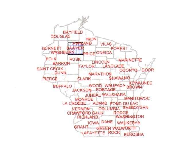
2 State Map

3 County map


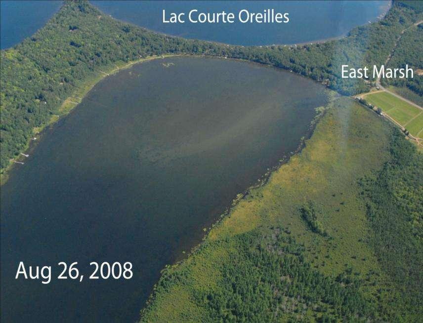
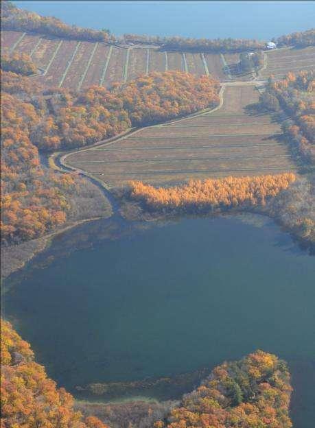
4 Lake map Lac Courte Oreilles Watershed 68,990 ac Lac Courte Oreilles

5 Hayward Round L Grindstone L LCO Sand L Whitefish L
6 Lac Courte Oreilles A very sensitive lake 5,039 acre --8 th largest natural drainage lake in Wisconsin, Classified: oligotrophic, Outstanding Resource Water (ORW) Max. depth 95 ft, Avg. depth ft, stratified two-story cold/cool/warm water fishery 68,990 acre watershed--84% forest /water/wetland 4% urban, 4% animal/crop agriculture Current condition: TP 10 ppb, Chl-a --2 ppb, Secchi--14 feet
7 WATER QUALITY # 1 THE 8 TH LARGEST LAKE IN THE STATE IS ON THE VERGE OF IRREVERSIBLE DECLINE OF ITS WATER QUALITY WHY? EXCESSIVE IN-FLOW OF NUTRIENTS PRIMARILY PHOSPHORUS
8
9
10
11

12
13
14 History of COLA In the early 1960 s Lac Courte Oreilles Protective Association formed Concerned about water quality, clarity, water levels, native plants and animals Funded first lake study of water quality BARR study (1996) est. base line nutrient study In 1995 COLA established as the official lake organization
15 History of LCOFI The Lac Courte Oreilles Foundation Inc. was founded in 2009 as a 501 (c) (3) non-profit Primary purpose is the protection, preservation, and restoration of the water quality of LCO COFI raises and uses funds to stop pollution, restore habitat, research and study water quality issues, combat AIS, and educate people about proper lake stewardship
16 LCO Tribe Tribe monitors water quality on all lakes within the reservation COLA partners with the Tribe Conservation Dept Water quality testing - Major input Tribe hired to complete grant funded studies on the lake On-going and detailed monitoring of Musky Bay water quality

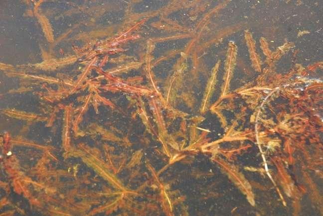
17 Tribal boundary line LCO TRIBAL LANDS
18 COLA Actions Staff and fund Clean Boats inspection program at DNR boat landing Monitor and treat AIS Purchase and maintain buoys Fish stocking Purchase and place fish cribs Water quality/clarity testing Lakes studies, grants, and plans Shoreland monitoring COLA officially supported previous litigation COLA e-blasts members on important issues affecting the lake Annual picnic for members and guests
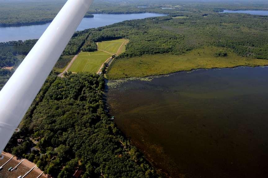
19 COFI Activities Raise funds for COLA activities Promote the education and awareness of lake issues to restore water quality Fund outside studies of lake i.e.. Turtle study Fund AIS treatments K per year

20 COFI Fund Raising Brochure

21 COFI Fund Raising Brochure
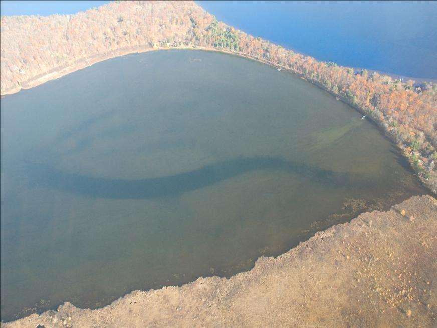
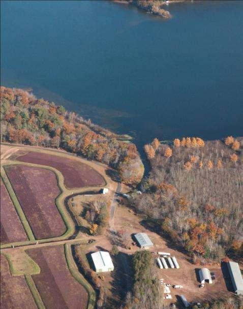
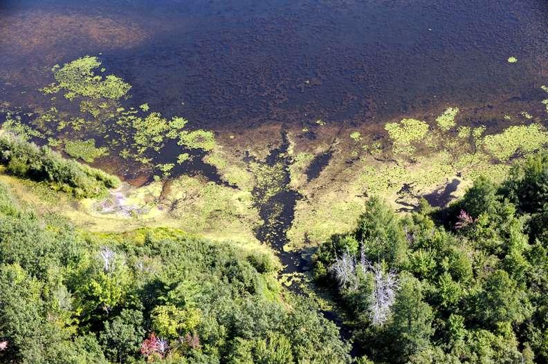
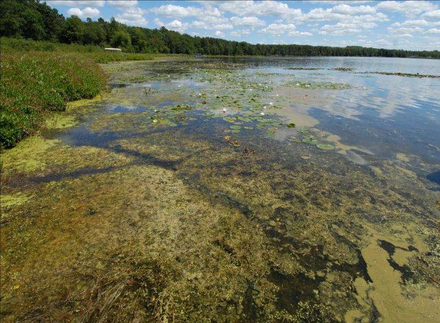
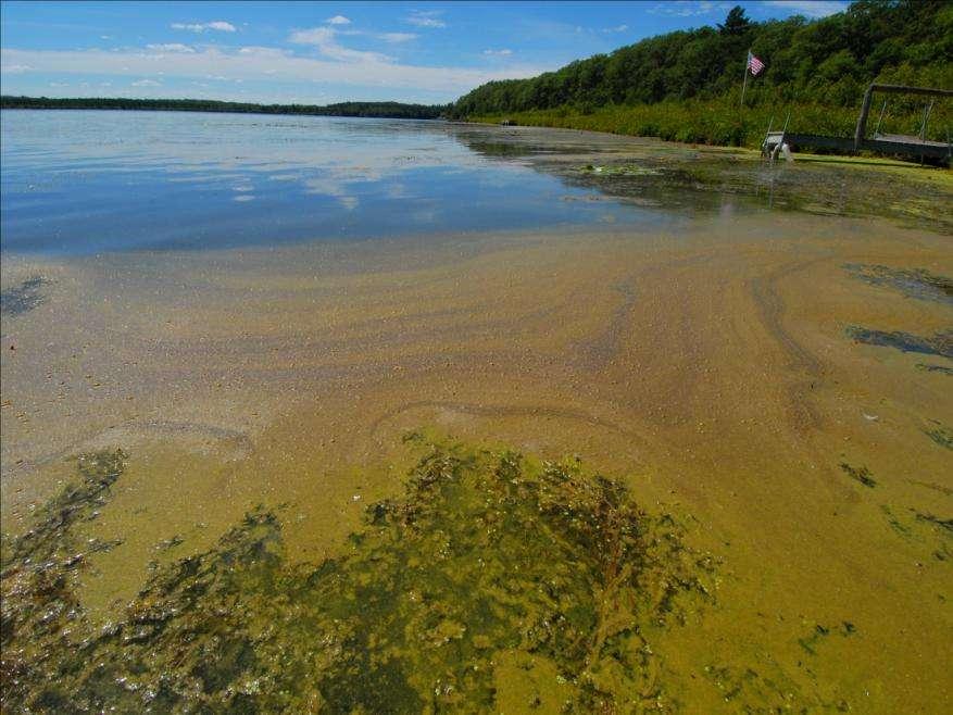
22 CHALLENGES FOR LCO THE 8 TH LARGEST LAKE IN THE STATE IS ON THE VERGE OF IRREVERSIBLE DECLINE OF ITS WATER QUALITY WHY? EXCESSIVE IN-FLOW OF NUTRIENTS PRIMARILY PHOSPHORUS THE PRIMARY SOURCE? CRANBERRY BOG DISCHARGES Effect of phosphorus on AIS in LCO
23


24 AIS in LCO 2009 CLP 2010 CLP

25 AIS in LCO untreated

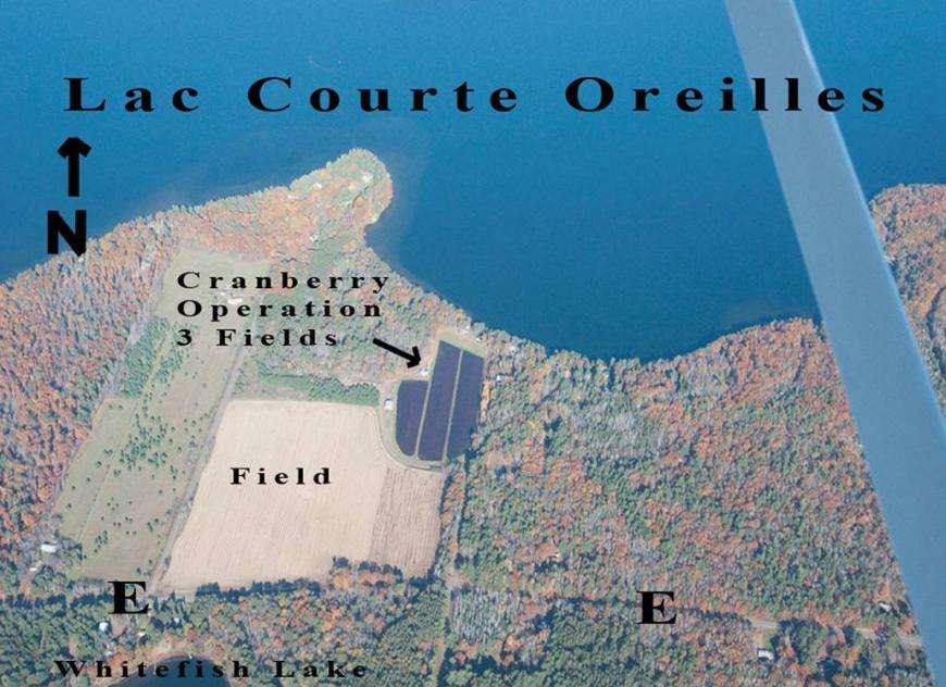
26 POINTS OF INFLOW

27 SOURCES OF PHOSPHORUS 78% OF THE CONTROLLABLE PHOPHORUS IN-FLOW INTO MUSKY BAY IS FROM CRANBERRY BOGS
28
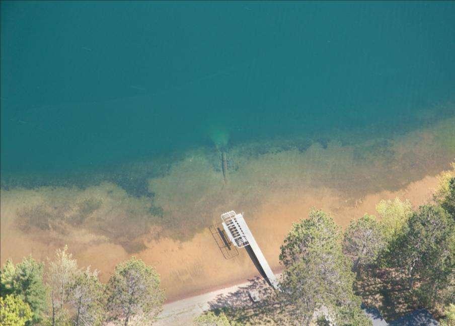
29
30

31
32
33

34 May 19, P levels times normal

35
36
37 May, 2010 Point source discharge pipe into the lake 40 +/- dia.
38
39
40 Major Concerns for LCO Slow degradation of water quality Explosive growth of Curly Leaf Pondweed (AIS) Fueled by excessive phosphorus inflow Changes in land use with LCO watershed Shoreland development and buffers
41 LCO and Cranberry bogs Cranberry bog discharges have the single greatest detrimental impact upon the water quality of Musky Bay and impacts LCO 15+ years of water testing, water studies, and legal action have proven this Bog discharges account for 78% of the controllable P inflow into Musky Bay Lack of meaningful regulation at local, regional, state, and federal levels
42 Cranberry Fun Facts Cranberry farms are exempt from DNR regulations related to water use cranberry law - NO regulations from DNR Cranberry farms do not report pesticide use only ag crop in State that does not (Lake Tides, Vol. 34, No.2 spring 2009) Cran Assoc advocates BMP #447 Tail water recovery system- 250 farms - only 12 use this BMP (2009). Their marketing leads you to believe all do NOT sustainable farming environmental impacts to surface waters
43 Cranberry Fun Facts pg 2 Cran Assoc has its own in-house liaison to NRCS Why does no other ag entity have a liaison? Great for marketing? OR do they have special conservation needs?
44 If we can t eliminate the controllable phosphorus inputs into the lake How will this affect us? Property Values Water Quality Watershed degradation Regional economics

45 The Lake Economy
46 WATER QUALITY- PROPERTY VALUES AS WATER QUALITY DEGRADES PROPERTY VALUES DECLINE AS LAKEFRONT PROPERTY VALUES DECLINE NON-LAKEFRONT TAXES GO UP
47 Competition for Travel and Tourism $ Travel and tourism relies upon discretionary dollars that can be spent in other competing areas for better (1) quality products and (2) quality of experience. Water Quality is Job #1. Northwood Charm product must compete against other states & Canada. Survey Respondents: 28% WI, 49% MN, 11% IL, OH, FL, KY, AZ, KS, GA, TX, HI, Mexico
48 Economic Survey (2009) 219 Respondents (out of 650) Northwood Charm has economic value Real estate value linked to clarity ~84,000 Visitor Days ~$11 to $15 million per year to local economy Average Family Spends ~$16,000/year

49 COLA Resident Expenditures: Significant (and Shouldn t Be Takenfor-Granted!) Dollars largely generated from out-of-region sources
50 COLA Real-Estate & Taxes(2009) $331 million tabulated Fair Market Value ~ 85% seasonal, 15% year-round residents $2.9 million local taxes ~ $ 2 million cranberry - FMV ~ $ 15,000 + cranberry taxes Watershed estimates - ~ 1.18 Billion dollars FMV ~10.4 million local taxes
51 Survey Results 93% Pursue Water-Based Recreation Boat, swim, fish strongly related to water quality 77% Perceived Excellent Water Quality at purchase 59% Perceive Water Quality Worse Today
52 Long-Term Considerations: Community Stability: 57% Long-term Family Ownership, 11% Plan Retirement Water quality strongly influences long-term ownership intent, based on loss of clarity 20% would not stay if lost avg 2-3 feet 49% would not stay if lost avg 4-6 feet 61% would not stay if lost avg 7-10 feet
53 LCO Lake Management Plan To achieve the water goals, COLA must address the following five management areas over the coming years and decades: 1. Cranberry Discharge 2. Changing land use in the LCO Watershed 3. LCO Shore Land Development and buffer areas 4. Invasive Species Management 5. Lake and Stream Monitoring 6. Establish a watershed coalition of all lake Assoc.
54 The Solution? Best Management Practice #447 Tail Water Recovery Systems
55 YOUR LAKE Do you have degraded water quality/clarity on your Lake? Is there excessive growth of native and invasive plants? Look around - is there a cranberry bog draining into your lake? Is there a bog upstream in your watershed? Grindstone Lake examples (1700 ppb measured)
Clam Lakes (Lower & Upper), Burnett County Four-Phased Lake Management Planning Project Description
, Burnett County Four-Phased Lake Management Planning Project Description") 1 Clam Lakes (Lower & Upper), Burnett County Four-Phased Lake Management Planning Project Description Lake and Watershed Characteristics The Clam Lakes are a combined 1544 acres with Upper Clam Lake essentially
1 Clam Lakes (Lower & Upper), Burnett County Four-Phased Lake Management Planning Project Description Lake and Watershed Characteristics The Clam Lakes are a combined 1544 acres with Upper Clam Lake essentially
JORDAN LAKE MANAGEMENT6 PLAN PT 2--REVISED 8/16/14 Page 19 ITEM GOALS and ACTION ITEMS WHO WHEN
 JORDAN LAKE MANAGEMENT6 PLAN PT 2--REVISED 8/16/14 Page 19 EDUCATION Goal A: Educate community and public about lake management concerns. 1. Establish community events to encourage & educate the community
JORDAN LAKE MANAGEMENT6 PLAN PT 2--REVISED 8/10/13 Page 19 ITEM GOALS and ACTION ITEMS WHO WHEN
 JORDAN LAKE MANAGEMENT6 PLAN PT 2--REVISED 8/10/13 Page 19 EDUCATION Goal A: Educate community and public about lake management concerns. 1. Establish community events to encourage & educate the community
Amnicon & Dowling Lakes Aquatic Plant Management Planning Project
 Amnicon & Dowling Lakes Aquatic Plant Management Planning Project Project Background Aquatic Invasive Species Education, Prevention and Planning Grant Application Submitted to WDNR in August 2011 Awarded
Erosion Vulnerability Index
 Erosion Vulnerability Index Evaluating the Vulnerability of Agricultural Lands to Erosion in the Upper Couderay River Watershed at the Parcel Level Presented by Douglas Miskowiak Senior GIS Education Specialist
Portage County Lake Planning Process
 Portage County Lake Planning Process Lake Leaders Kemp Field Station September 2010 Jen McNelly and Nancy Turyk Center for Watershed Science and Education UW-Stevens Point Types of Planning Emotional Crisis
CLMP+ Report on Grass Lake (Anoka County) Lake ID# CLMP+ Data Summary
 Lake ID# CLMP+ Data Summary") CLMP+ Report on Grass Lake (Anoka County) Lake ID# 02-0113-00 2012-2013 CLMP+ Data Summary October 2014 Authors Shannon Martin, MPCA Editing and graphic design Public Information Office Staff The (MPCA)
CLMP+ Report on Grass Lake (Anoka County) Lake ID# 02-0113-00 2012-2013 CLMP+ Data Summary October 2014 Authors Shannon Martin, MPCA Editing and graphic design Public Information Office Staff The (MPCA)
Hubbard County Water Quality and You Celebrating 20 Years of Water Quality Testing in Hubbard County!
 Hubbard County Water Quality and You Celebrating 20 Years of Water Quality Testing in Hubbard County! A Collaborative Effort by: Citizen Volunteers Hubbard County Coalition of Lake Associations (HC COLA)
DNR Lake Vegetation Management Plan
 DNR Lake Vegetation Management Plan Lake Sarah, Hennepin County (DOW# 27019100) Final LVMP with Signatures Date Signed: 3/27/2018 Expiration Date: 3/27/2023 Management Targets(s): Curly-leaf pondweed (CLP)
awetlands aprairie aforests ahabitat for Fish, Game & Wildlife
 Rec. H1 priority land habitats pp. 63-67 Priority areas identified in integrated mapping assessing critical land habitat and threats to habitat pp.33-63 o Mapping is scalable for use in localized areas
VADNAIS LAKE AREA WATER MANAGEMENT ORGANIZATION Sustainable Lake Management Plan Charley Lake, Ramsey County, MN
 VADNAIS LAKE AREA WATER MANAGEMENT ORGANIZATION Sustainable Lake Management Plan Charley Lake, Ramsey County, MN Prepared by Kristine Jenson, Tyler Thompson, and Dawn Tanner December 2018 VADNAIS LAKE
2017 Data Report for Perch Lake, Iron County
 Michigan Lakes Ours to Protect 217 Data Report for Perch Lake, Iron County Site ID: 3646 46.361392 N, 88.658338 W The CLMP is brought to you by: 1 About this report: This report is a summary of the data
2018 Data Report for. Lotus Lake, Oakland County
 Michigan Lakes Ours to Protect 218 Data Report for Lotus Lake, Oakland County 42.6941 N, 83.4244 W The CLMP is brought to you by: 1 About this report: This report is a summary of the data that have been
2016 Data Report for Iron Lake, Iron County
 Michigan Lakes Ours to Protect Data Report for Iron Lake, Iron County.1397 N,.533 W The CLMP is brought to you by: 1 About this report: This report is a summary of the data that have been collected through
Gull Lake CASS & CROW WING COUNTIES
 Gull Lake 11-0305-00 CASS & CROW WING COUNTIES Summary Gull Lake is located just northwest of Brainerd, Minnesota, on the border of Cass and Crow Wing Counties. It covers 9,947 acres, which places it in
2017 Data Report for Ottawa Lake, Iron County
 Michigan Lakes Ours to Protect 2017 Data Report for Site ID: 360033 46.08484 N, 88.76419 W The CLMP is brought to you by: 1 About this report: This report is a summary of the data that have been collected
Water Quality in Mayflower Lake. N. Turyk Water Resource Scientist UW-Stevens Point
 Water Quality in Mayflower Lake N. Turyk Water Resource Scientist UW-Stevens Point Tonight s discussion Water movement Water quality Zoning/Build-outs in the Watersheds Recommendations and Considerations
BIG ROCHE A CRI LAKE CHARACTERISTICS
 BIG ROCHE A CRI LAKE CHARACTERISTICS Lake Description Big Roche Cri Lake is located in north central Adams County and has a surface area of 205 acres, a shoreline length of 6.1 mile, a volume of 6,993
2016 Data Report for Magician Lake, Cass County
 Michigan Lakes Ours to Protect 216 Data Report for Magician Lake, Cass County Site ID: 1465 42.649 N, 86.179 W The CLMP is brought to you by: 1 About this report: This report is a summary of the data that
Mayflower Lake Management Planning Committee UWSP Center for Watershed Science and Education Marathon County Wisconsin Department of Natural
 Mayflower Lake Management Planning Committee UWSP Center for Watershed Science and Education Marathon County Wisconsin Department of Natural Resources Reduces conflicts Addresses problems Allows for proactive
2017 Data Report for Hoags Lake, Mason County
 Michigan Lakes Ours to Protect 17 Data Report for Hoags Lake, Mason County.171 N,.19575 W The CLMP is brought to you by: 1 About this report: This report is a summary of the data that have been collected
The Boardman: A River Reborn Project Fact Sheet
 The Boardman: A River Reborn Project Fact Sheet What is The Boardman: A River Reborn Project? In 2005, Traverse City Light and Power determined that is was not economically feasible to produce hydropower
Phosphorus Goal Setting Process Questions and Answers 2010
 Lake Winnipesaukee Watershed Management Plan Phase I: Meredith, Paugus, Saunders Bays 1. What is phosphorus? Phosphorus (P) is a naturally occurring element and a major nutrient required for biological
Sustaining Colorado s Watersheds: Making the Water Quality Connections October 2-4, 2007
 Sustaining Colorado s Watersheds: Making the Water Quality Connections October 2-4, 2007 Barr Lake and Milton Reservoir Watershed Management Plan ~ Brief History of the Reservoirs ~ Overview of the BMW
Big Chetac Lake Getting Rid of the Green Phase 3. Nutrient Budget and Management Data Analysis Report
 Big Chetac Lake Getting Rid of the Green Phase 3 Nutrient Budget and Management Data Analysis Report Prepared for: Big Chetac Chain Lake Association and Wisconsin Department of Natural Resources Prepared
2018 Data Report for Pickerel Lake, Kalkaska County
 Michigan Lakes Ours to Protect 2018 Data Report for Pickerel Lake, Kalkaska County Site ID: 400035 44.800559 N, 84.97667 W The CLMP is brought to you by: 1 About this report: This report is a summary of
Portage Lake Hubbard County
 Prepared in cooperation with the Minnesota Department of Natural Resources Minnesota Lake ID: 9- Area: acres Watershed Area: 6,7 acres Ecoregion: Northern Lakes and Forests (NLF) Portage Lake Hubbard County
2016 Data Report for Bruin Lake, Washtenaw County
 Michigan Lakes Ours to Protect 1 Data Report for Bruin Lake, Washtenaw County Site ID: 8575.189788 N, 8.39387 W The CLMP is brought to you by: 1 About this report: This report is a summary of the data
An Overview of Vermont s Clean Water Act Julie Moore, P.E. August 14, 2017
 An Overview of Vermont s Clean Water Act Julie Moore, P.E. August 14, 2017 (with credit due to Marli Rupe) 1 What is a TMDL? (Total Maximum Daily Load) 1. The maximum amount (load) of a pollutant any surface
Red Rock Lake: A Path Forward
 University of Minnesota Morris Digital Well University of Minnesota Morris Digital Well Center for Small Towns 6-2016 Red Rock Lake: A Path Forward Colette Millard Student - University of Minnesota, Morris
3D modeling and prediction of coolwater fish habitat under changing climate
 3D modeling and prediction of coolwater fish habitat under changing climate Shahram Missaghi Water Resources Team; University of Minnesota Extension 4100 220th Street W.; Farmington, MN 55024-8087 Miki
2018 Data Report for. Crystal Lake, Montcalm County
 Michigan Lakes Ours to Protect 218 Data Report for Crystal Lake, Montcalm County Site ID: 5915 43.25584 N, 84.93362 W The CLMP is brought to you by: 1 About this report: This report is a summary of the
2015 Data Report for South Torch Lake, Antrim County
 Michigan Lakes Ours to Protect 2015 Data Report for South Torch Lake, Antrim County Site ID: 050240 44.91590 N, 85.30280 W The CLMP is brought to you by: About this report: This report is a summary of
2017 Data Report for Shingle Lake, Clare County
 Michigan Lakes Ours to Protect 217 Data Report for Shingle Lake, Clare County Site ID: 1818 43.96359 N, 84.95282 W The CLMP is brought to you by: 1 About this report: This report is a summary of the data
2016 Data Report for Barlow Lake, Barry County
 Michigan Lakes Ours to Protect 216 Data Report for Barlow Lake, Barry County Site ID: 8176 42.67559 N, 85.5242 W The CLMP is brought to you by: 1 About this report: This report is a summary of the data
East Okoboji Lake Aquatic Vegetation Management Plan. Curlyleaf Pondweed Control
 East Okoboji Lake Aquatic Vegetation Management Plan Curlyleaf Pondweed Control What is Curlyleaf Pondweed? Non-native submersed, rooted aquatic plant Introduced in the mid 1800 s First found in Iowa
2017 Data Report for Earl Lake, Livingston County
 Michigan Lakes Ours to Protect 217 Data Report for Earl Lake, Livingston County Site ID: 755 2.191 N, 3.95 W The CLMP is brought to you by: 1 About this report: This report is a summary of the data that
2017 Data Report for Big Maggie Lake, Iron County
 Michigan Lakes Ours to Protect 2017 Data Report for Big Maggie Lake, Iron County Site ID: 360173 46.01 N, 88.4626 W The CLMP is brought to you by: 1 About this report: This report is a summary of the data
2017 Data Report for Painter Lake, Cass County
 Michigan Lakes Ours to Protect 217 Data Report for Painter Lake, Cass County Site ID: 1418 41.81667 N, 85.99194 W The CLMP is brought to you by: 1 About this report: This report is a summary of the data
Portage Lake CASS COUNTY
 Portage Lake 11-0204-00 CASS COUNTY Summary Portage Lake is located near Bena, MN in Cass County. It covers 1,539 acres, which places it in the upper 10% of lakes in Minnesota in terms of size. Portage
2017 Data Report for Arbutus Lake, Grand Traverse County
 Michigan Lakes Ours to Protect 217 Data Report for Arbutus Lake, Grand Traverse County Site ID: 2819 44.65917 N, 85.519726 W The CLMP is brought to you by: 1 About this report: This report is a summary
2017 Data Report for Duck Lake, Muskegon County
 Michigan Lakes Ours to Protect 217 Data Report for Duck Lake, Muskegon County Site ID: 61778 43.33785 N, 86.39258 W The CLMP is brought to you by: 1 About this report: This report is a summary of the data
2017 Data Report for Fern Lake, Grand Traverse County
 Michigan Lakes Ours to Protect 2017 Data Report for Site ID: 280438 44.73475 N, 85.73409 W The CLMP is brought to you by: 1 About this report: This report is a summary of the data that have been collected
Phase III Watershed Implementation Plans
 Phase III Watershed Implementation Plans Including programmatic outcomes in your planning to provide co-benefits for your community and reduce pollution Rachel Felver Chesapeake Bay Program Director of
2017 Data Report for Rogers Pond, Mecosta County
 Michigan Lakes Ours to Protect 2017 Data Report for 43.6175478 N, 85.4718313 W The CLMP is brought to you by: 1 About this report: This report is a summary of the data that have been collected through
2017 Data Report for Deer Lake, Alger County
 Michigan Lakes Ours to Protect 2017 Data Report for Deer Lake, Alger County Site ID: 020127 46.48016 N, 86.98277 W The CLMP is brought to you by: 1 About this report: This report is a summary of the data
2017 Data Report for Lake Tahoe, Oceana County
 Michigan Lakes Ours to Protect 17 Data Report for Lake Tahoe, Oceana County Site ID: 33 3.1 N,.3 W The CLMP is brought to you by: 1 About this report: This report is a summary of the data that have been
2017 Data Report for Pleasant Lake, Wexford County
 Michigan Lakes Ours to Protect 2017 Data Report for Pleasant Lake, Wexford County Site ID: 830183 44.3 N, 85.4775 W The CLMP is brought to you by: 1 About this report: This report is a summary of the data
2017 Data Report for Loon Lake, Iosco County
 Michigan Lakes Ours to Protect 2017 Data Report for Loon Lake, Iosco County Site ID: 350078 The CLMP is brought to you by: 1 About this report: This report is a summary of the data that have been collected
2017 Data Report for Oxbow Lake, Oakland County
 Michigan Lakes Ours to Protect 2017 Data Report for Oxbow Lake, Oakland County Site ID: 630666 42.64167 N, 83.477226 W The CLMP is brought to you by: 1 About this report: This report is a summary of the
Blue Lake Stormwater Retrofit Analysis
 P a g e 1 Blue Lake Stormwater Retrofit Analysis Prepared by: Isanti Soil and Water Conservation District And Sherburne Soil and Water Conservation District P a g e 4 Executive Summary Blue Lake and its
Northern Chain of Lakes
 Northern Chain of Lakes Presented by Pat Conrad and Joe Pallardy on behalf of the Brown s Creek Watershed District Board of Managers w a t e r I e c o l o g y I c o m m u n i t y Lake by Lake Analysis
3D WETLAND MANAGEMENT
 3D WETLAND MANAGEMENT 1. ISSUE Wetlands are one of the most productive ecosystems. They provide biological and chemical functions to the landscape that serve the watershed including the moderation of nutrient
Purpose of Shoreland Zoning:
 January, 2016 Purpose of Shoreland Zoning: 1. Further the maintenance of safe and healthful conditions 2. Prevent and control water pollution 3. Protect spawning grounds, fish, and aquatic life 4. Regulate
2017 Data Report for Portage Lake, Washtenaw County
 Michigan Lakes Ours to Protect 2017 Data Report for Portage Lake, Washtenaw County Site ID: 810248 42.420559 N, 83.921392 W The CLMP is brought to you by: 1 About this report: This report is a summary
Northeastern Forest and Conservation Nursery Association
 Northeastern Forest and Conservation Nursery Association Springfield, IL July 14 17, 2003 Illinois Conservation Reserve Enhancement Program (CREP): A Model for Watershed Restoration Debbie Bruce Debbie
2017 Data Report for Silver Lake, Van Buren County
 Michigan Lakes Ours to Protect 2017 Data Report for Silver Lake, Van Buren County Site ID: 800534 42.3891 N, 86.0599 W The CLMP is brought to you by: 1 About this report: This report is a summary of the
ONTONAGON RIVER BOND FALLS HYDROELECTRIC PROJECT (P-1864)
") ONTONAGON RIVER BOND FALLS HYDROELECTRIC PROJECT (P-1864) A. SUMMARY 1. License Issued: August 20, 2003 2. Expiration: July 31, 2043 3. Waterway: Ontonagon River 4. Capacity: 12 MW (megawatts) 5. Licensee:
ONTONAGON RIVER BOND FALLS HYDROELECTRIC PROJECT (P-1864) A. SUMMARY 1. License Issued: August 20, 2003 2. Expiration: July 31, 2043 3. Waterway: Ontonagon River 4. Capacity: 12 MW (megawatts) 5. Licensee:
A Citizen led Success Story to Improve Water Quality and Battle AIS
 A Citizen led Success Story to Improve Water Quality and Battle AIS English Lake Protection and Rehabilitation District in Manitowoc County Presenter: Tom Ward, Invasive Species Coordinator, Manitowoc
Phosphorus Rules NR , NR 151 and NR 217 Subchapter III
 Phosphorus Rules NR 102.06, NR 151 and NR 217 Subchapter III Jim Baumann Wisconsin Department of Natural Resources james.baumann@wisconsin.gov 608/266-9277 Phosphorus 3 Rule Changes S. NR 102.06 phosphorus
Movil Lake BELTRAMI COUNTY
 Movil Lake 04-0152-00 -BELTRAMI COUNTY Lake Water Quality Summary Movil Lake is located 8 miles north of Bemidji, MN in Beltrami County. It is an irregular shaped lake covering 853 acres with a maximum
CHAPTER 4 WATERSHED PLAN GOALS & OBJECTIVES
 4.0 Introduction CHAPTER 4 WATERSHED PLAN GOALS & OBJECTIVES After the watershed analysis had been completed, the next step in the planning process followed by the group was to come up with goals and objectives
Cannon River One Watershed, One Plan. POLICY COMMITTEE MEETING January 10, 2018 Rice County Government Center Faribault, MN
 Cannon River One, One Plan POLICY COMMITTEE MEETING January 10, 2018 Rice County Government Center Faribault, MN TASK Task 1. Aggregate Existing Physical & Spatial Data 1A. Create project maps 1B. Meeting
Wakefield Lake TMDL Public Meeting 3/17/2014. Jen Koehler, PE Barr Engineering
 Wakefield Lake TMDL Public Meeting 3/17/2014 Jen Koehler, PE Barr Engineering Outline Project Contacts Introduction to Wakefield Lake Thoughts/Questions/Concerns About TMDL Studies Lake Water Quality and
Green Lake Subwatershed Retrofit Analysis For Areas Draining Directly to the Lake
 Green Lake Subwatershed Retrofit Analysis For Areas Draining Directly to the Lake Prepared by: Isanti Soil and Water Conservation District in partnership with the Metro Conservation Districts Funding provided
Long Prairie River Watershed Restoration and Protection Strategies (WRAPS) Report Summary
 Report Summary") Long Prairie River Watershed Restoration and Protection Strategies (WRAPS) Report Summary Minnesota has adopted a watershed approach to address the state s 80 major watersheds (denoted by 8-digit hydrologic
Long Prairie River Watershed Restoration and Protection Strategies (WRAPS) Report Summary Minnesota has adopted a watershed approach to address the state s 80 major watersheds (denoted by 8-digit hydrologic
Environment and Natural Resources Trust Fund 2018 Request for Proposals (RFP)
") Environment and Natural Resources Trust Fund 2018 Request for Proposals (RFP) Project Title: Prioritize and Target North-Central Minnesota Lakes for Protection Category: G. Land Acquisition, Habitat and
Environment and Natural Resources Trust Fund 2018 Request for Proposals (RFP) Project Title: Prioritize and Target North-Central Minnesota Lakes for Protection Category: G. Land Acquisition, Habitat and
Water Quality Standards What s coming up for lakes? Kristi Minahan, WI DNR WI Lakes Convention April 7, 2017
 Water Quality Standards What s coming up for lakes? Kristi Minahan, WI DNR WI Lakes Convention April 7, 2017 Water Quality Standards Water Quality Standards 1. Designated Uses 2. Water Quality Criteria
Wisconsin Wastewater Operators Association. Protecting Our Water Resources: The Future Bill Hafs - NEW Water 10/2014
 Wisconsin Wastewater Operators Association Protecting Our Water Resources: The Future Bill Hafs - NEW Water 10/2014 The Fox River Contributes 1/3 of All Nutrients to Lake Michigan APRIL 15, 2011 Photo
2017 Data Report for Little Paw Paw Lake, Berrien County
 Michigan Lakes Ours to Protect 2017 Data Report for Site ID: 110765 42.21899 N, 86.29072 W The CLMP is brought to you by: 1 About this report: This report is a summary of the data that have been collected
What s New in Shoreland Zoning and the Scientific Research Behind It. Lynn Markham WLWCA March 11, 2014
 What s New in Shoreland Zoning and the Scientific Research Behind It Lynn Markham WLWCA March 11, 2014 Outline Shoreland zoning 101 - in 2 minutes or less Recent research: How impervious surfaces impact
Hadlock Pond, Washington Co., Lake Hadlock Association, Inc.
 Hadlock Pond, Washington Co., Lake Hadlock Association, Inc. Lake Characteristics Watershed Characteristics Surface Area (ac/ha) Max Depth (ft/m) Mean Depth (ft/m) Retention Time (years) Water Class Dam
Mud Lake Lakeshed Assessment
 Mud Lake Lakeshed Assessment The lakeshed vitals table identifies where to focus organizational and management efforts for each lake. Criteria were developed using limnological concepts to determine the
Lakes and Wetlands and the Economy of Vilas County
 Lakes and Wetlands and the Economy of Vilas County Outline The aquatic habitats of Vilas County The economic value of those aquatic habitats How the Vilas County Land & Water Conservation fits in to the
(Must be a county, city, township, watershed district, watershed management organization or joint powers organization.)
") 2010 Proposal Form Minnesota Clean Water Partnership (CWP) Resource Investigation Project Implementation Project Doc Type: Proposal Proposal Deadline: 4:30 p.m. Friday, August 13, 2010 Review the 2010
2010 Proposal Form Minnesota Clean Water Partnership (CWP) Resource Investigation Project Implementation Project Doc Type: Proposal Proposal Deadline: 4:30 p.m. Friday, August 13, 2010 Review the 2010
Healthy Lakes have value to a community for a number of reasons. They provide a
 Rice Lake Eastern Marathon County Lake Study Preliminary Results 2010-2012 University of Wisconsin-Stevens Point and Marathon County Staff and Citizens Healthy Lakes have value to a community for a number
CLMP+ Report on Fleming Lake (Aitkin County)
") CLMP+ Report on Fleming Lake (Aitkin County) Lake ID# -5-5-6 CLMP+ Data Summary July 7 Authors Shannon Martin Contributors/acknowledgements Terry Dahlberg Sandy Dahlberg Pam Anderson For questions regarding
CLMP+ Report on Fleming Lake (Aitkin County) Lake ID# -5-5-6 CLMP+ Data Summary July 7 Authors Shannon Martin Contributors/acknowledgements Terry Dahlberg Sandy Dahlberg Pam Anderson For questions regarding
Lake Partnerships. Assembly Required
 Lake Partnerships Assembly Required WATERSHED INTRODUCTION Charlie Marks, Green Lake Sanitary District Wisconsin s Major Watersheds Big Green Lake Green Lake Watershed Watershed Area 107 square miles County
C. Staffing Needs Approximately 150 staff days TSA #3 staff time will also be utilized.
 2017 Annual Plan I. Introduction The purpose of this annual plan is to detail work items that will be completed in 2017. The annual plan will provide a tool for SWCD staff and supervisors to evaluate program
2017 Data Report for Klinger Lake, St. Joseph County
 Michigan Lakes Ours to Protect 217 Data Report for Klinger Lake, St. Joseph County Site ID: 75136 41.82781 N, 85.543893 W The CLMP is brought to you by: 1 About this report: This report is a summary of
Final TMDL Implementation Plan. Prepared for Minnesota Pollution Control Agency
 Wirth Lake Final TMDL Implementation Plan Prepared for Minnesota Pollution Control Agency September 2010 4700 West 77 th Street Minneapolis, MN 55435-4803 Phone: (952) 832-2600 Fax: (952) 832-2601 wq-iw11-03c
2017 Data Report for Lake Independence, Marquette County
 Michigan Lakes Ours to Protect 217 Data Report for Lake Independence, Marquette County Site ID: 2149 46.88337 N, 87.711393 W The CLMP is brought to you by: 1 About this report: This report is a summary
ANCR INDIVIDUAL RESPONSES SUMMARY: 2/11/04 WATER RESOURCES GOALS AND OBJECTIVES
 ANCR INDIVIDUAL RESPONSES SUMMARY: 2/11/04 WATER RESOURCES GOALS AND OBJECTIVES Goal 1: Protect the health and safety of the Dane County population. a. Prevent development that may have an adverse effect
Lake Creek Watershed Management Plan Public Meeting. Arrowhead Lake May 3, :00 PM
 Lake Creek Watershed Management Plan Public Meeting Arrowhead Lake May 3, 2018 6:00 PM Agenda I. Welcome and Introductions II. III. IV. Watershed Basics Overview of Lake Creek Watershed Elements of a Successful
US Forest Service Open Space Conservation Strategy
 US Forest Service Open Space Conservation Strategy Transportation Research Board September 3, 2008 Atlanta, Georgia Photo Credit: Regents at the University of Minnesota. All rights reserved. Used with
Shawano Area Waterways Management, Inc.
 WISCONSIN DEPARTMENT OF NATURAL RESOURCES AQUATIC INVASIVE SPECIES GRANT PROGRAM Application Overview Materials Shawano Lake AIS Control and Prevention Project Phase 1: Trial EWM Treatment Prepared for
Providing local politically supported water access opportunities to the waterways of Virginia s Middle Peninsula
 Contact: Lewis Lawrence Title: Director of Regional Planning Affiliation: Middle Peninsula Planning District Commission Address: P.O. Box 286 Saluda, Virginia 23149 Email address: LLawrence@mppdc.com Phone:
2016 Summit Lake Water Quality Report Prepared by Thurston County Environmental Health Division
 ! 216 Summit Lake Water Quality Report Prepared by Thurston County Environmental Health Division PART OF TOTTEN INLET WATERSHED LENGTH OF LAKE: 2.2 miles SHORELINE LENGTH: 5.6 miles LAKE SIZE: 53 acres
Whitefish Lake CROW WING COUNTY
 Lake 18-0310-00 CROW WING COUNTY Lake Water Quality Summary Lake is located just east of Pine River, Minnesota. It covers 7,715 acres, which places it in the upper 5% of lakes in Minnesota in terms of
WATERSHEDS. City Council Workshop August 21, 2018
 WATERSHEDS City Council Workshop August 21, 2018 Watersheds City of Ames was a founding member of the 28E Agreement that established the Squaw Creek Watershed Management Authority in 2012 Reduce Riverine
2016 Data Report for Klinger Lake, St. Joseph County
 Michigan Lakes Ours to Protect 216 Data Report for Klinger Lake, St. Joseph County Site ID: 75136 41.82781 N, 85.543893 W The CLMP is brought to you by: 1 About this report: This report is a summary of
Contiguous Lots, Relationships & Special Topics Fall Darrin Hoverson Area Hydrologist
 Contiguous Lots, Relationships & Special Topics Fall 2018 Darrin Hoverson Area Hydrologist 1. Nonconforming Lots 2. SL Model Ordinance Update 3. New Review Process 4. Website Resources Regs & Administration
Working with partners to manage Invasive Aquatic Plants
 Working with partners to manage Invasive Aquatic Plants By: Chip Welling Coordinator, Management of Invasive Aquatic Species MnDNR To: State of Water conference Alexandria Date: 2016 April 15 S-o-W_2016_Apr_15-CW.ppt
Addressing Water Quality in the East Fork Watershed: A Collaborative Effort
 Addressing Water Quality in the East Fork Watershed: A Collaborative Effort John McManus and Jake Hahn Clermont (OH) Soil & Water Conservation District OKI Annual Meeting Cincinnati Nature Center March
BWSR PROGRAMS THAT ADDRESS NUTRIENT LOSS
 BWSR PROGRAMS THAT ADDRESS NUTRIENT LOSS DRAINAGE LAW BUFFER PROGRAM CREP - GRANT PROGRAMS - PROJECTS 2017 MVTL Agronomy Update Meeting New Ulm, MN February 28, 2017 Jill Sackett Eberhart ~ BWSR Board
A Lake Classification and Conservation Portfolio for Wisconsin
 A Lake Classification and Conservation Portfolio for Wisconsin Kristen Blann Freshwater ecologist The Nature Conservancy Based on development of the lake classification and conservation portfolio for MN,
WATERSHED MANAGEMENT IN MINNESOTA. GOVERNANCE, PLANNING, AND FUNDING June 19, 2018 Cedar Rapids, Iowa
 WATERSHED MANAGEMENT IN MINNESOTA GOVERNANCE, PLANNING, AND FUNDING June 19, 2018 Cedar Rapids, Iowa GOVERNANCE - WD 1955 Watershed Act (MN Statute 103D) Local petition to form VOLUNTARY watershed district
Minnesota s Alternative Shoreland Management Standards
 Minnesota s Shoreland Management Standards In summary, the Standards include, but are not limited to: Multiple shoreland lake classifications on a single lake, for example, a natural environment bay of
Potato Lake 2010 Project Results and APM Plan. Saturday May 28, 2011 Dave Blumer, Jake Macholl SEH Lake Scientists
 Potato Lake 2010 Project Results and APM Plan Saturday May 28, 2011 Dave Blumer, Jake Macholl SEH Lake Scientists Lake and Aquatic Plant Management Planning Goal: To maintain or improve the overall condition
Boy Lake CASS COUNTY
 Boy Lake 11-143- CASS COUNTY Summary Boy Lake is located near Remer, MN in Cass County. It covers 3,452 acres, which places it in the upper 1% of lakes in Minnesota in terms of size. Boy Lake has two main