Wakefield Lake TMDL Public Meeting 3/17/2014. Jen Koehler, PE Barr Engineering
|
|
|
- Alan Fitzgerald
- 6 years ago
- Views:
Transcription


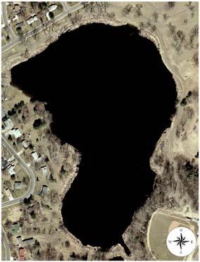
1 Wakefield Lake TMDL Public Meeting 3/17/2014 Jen Koehler, PE Barr Engineering Outline Project Contacts Introduction to Wakefield Lake Thoughts/Questions/Concerns About TMDL Studies Lake Water Quality and Ecology 101 Sources of Phosphorus to Wakefield Lake Wakefield Lake TMDL What are we going to do?? Follow-up Questions 1


2 Wakefield Lake Project Contacts Brooke Asleson MPCA Project Manager Tina Carstens RWMWD Representative Erin Anderson Wenz & Jen Koehler Barr Engineering Project Contacts What is a watershed? A watershed is an area of land from which all of the storm water that it drains flows to the same place a river, stream or lake. Topography Storm sewer Other drainage features Source: MPCA 2


3 Wakefield Lake Watershed Watershed Characteristics Watershed Area = 944 acres Direct Watershed to Lake Surface Area = 43:1 Varied Land Use fully developed 3
4 Wakefield Lake Characteristics Surface Area = 22 acres Maximum Depth = 9 feet Average Depth = 5 feet MPCA Shallow Lake Littoral Area (Area with enough light for plants to grow) = 22 acres (100%) Dominated by Aquatic Plants Mixes many times throughout the summer Primarily panfish; no carp observed to date Sediment Cores and Fossil Diatom Analysis What are your thoughts and experiences in relation to Wakefield Lake? Do you have any past memories or experiences to share? What do you think of when you think of Wakefield Lake? What are your concerns? Do you have a vision for the lake? 4
5 Let s Clarify the Terminology Impaired: When a water body fails to meet standards set by MPCA, it is listed as an impaired on the MPCA 303(d) Impaired Waters List and a Total Maximum Daily Load (TMDL) study is required Required by Section 303(d) of the Federal Clean Water Act TMDL Total Maximum Daily Load: Water quality study to determine allowable pollutant loading from point and nonpoint sources to lakes/rivers so as to achieve the water quality standards Approved by both the MPCA and the USEPA Wakefield Lake Historic Water Quality Total Phosphorus TP TP Concentration (mg/l) ( g/l) Average for Past 10 Years ( ) = 360 Average for Past 10-Years = 114 ug/l ug/l MPCA Shallow MPCA Shallow Lake Criteria = Lake Criteria = 60 g/l 60 g/l Impaired for Excess Nutrients Listed in 2002 Wakefield Lake Growing Growing Season (June --September) Mean Mean Total Total Phosphorus Concentrations 1979, ,


: MPCA MDNR BWSR MetCouncil RWMWD")
6 TMDL Study Process Assess Water Quality Determine Pollutant Sources Evaluate Response to Pollutants Develop Protection and Improvement Strategies Stakeholder Participation Wakefield Lake TMDL MS4s & Stakeholders MS4s: City of Maplewood City of St. Paul City of North St. Paul Ramsey County And ALL of you!! Technical Stakeholders (TAC): MPCA MDNR BWSR MetCouncil RWMWD Ramsey Conservation District 6


 Where does the phosphorus come from?")

7 TMDL study focuses on excess nutrients The Problem: Cultural Eutrophication The accelerated increase in concentrations of nutrients, primarily phosphorus and nitrogen, in a lake as a result of human activities in the watershed Water Quality Parameters: - Total Phosphorus (TP) - Chlorophyll a (Chl a) - Secchi Disk Transparency (SD) Where does the phosphorus come from? External Sources Stormwater runoff from hard (impervious) surfaces Soil erosion Pet/animal waste Leaves & grass clippings Fertilizers Septic systems Point discharges 7


8 Where does the phosphorus come from? Internal Sources Phosphorus can be stored in lake bottom sediments and released when oxygen levels are low Bottom sediment can also be re-suspended and bring phosphorus into the water column P P P P P P P Where does the phosphorus come from? Internal Sources Die-off of aquatic plants releases phosphorus to the lake water 8


9 Lake ecology: Shallow vs. Deep Lakes Lake ecology There is a wide spectrum between deep lakes and wetlands Deep Lakes Wetlands Shallow lakes fall in middle of the spectrum Generally less than 10 feet deep, with maximum depth of 15 feet 9

 Shallow versus deep lakes Shallow lakes do not form")

10 Shallow versus deep lakes During the summer, deep lakes thermally stratify, separating into layers based on temperature Graphic from Fin Farm LLC ( Shallow versus deep lakes Shallow lakes do not form stable, distinct thermal layers Layers mix frequently throughout summer Phosphorus released from bottom sediments will mix throughout summer 10


 Algae and")


11 Shallow lakes have two typical states 1. Healthy, clear water state Lush and diverse aquatic plant population Balanced, healthy ecosystem Clear water Shallow lakes have two typical states 2. Turbid State (Algal-Dominated) Algae and sediment prevent aquatic plant growth Without aquatic plants, water stays cloudy Poor habitat for diverse fish & invertebrate population Wind and bottom feeding fish re-suspend sediment 11

 Loss of dissolved oxygen in")


12 Excess phosphorus fuels Eutrophication Phosphorus feeds algae and causes algal blooms Algae decreases water transparency (or clarity) Loss of dissolved oxygen in water near the lake bottom Shift in the lake ecosystem Fewer Plants Impacts on Zooplankton Shift in fish species from gamefish to fish species tolerant of low oxygen levels (carp & bullheads) TMDL Estimation Methods Data Review Review monitoring data What does this data tell us? Water Quality Sediment Data Aquatic Plants Fishery 12
 = 360 Average for Past 10-Years = 114 ug/l 360 106 ug/l 263 263 MPCA Shallow 228 228 Lake MPCA Criteria Shallow = Lake Criteria 60 g/l = 60 g/l")

 Lake Surface MPCA Standard = 60 g/l Lake")
13 Wakefield Lake Historic Water Quality Total Phosphorus TP TP Concentration (mg/l) ( g/l) Average for Past 10 Years ( ) = 360 Average for Past 10-Years = 114 ug/l ug/l MPCA Shallow Lake MPCA Criteria Shallow = Lake Criteria 60 g/l = 60 g/l Wakefield Lake Growing Growing Season (June --September) Mean Mean Total Total Phosphorus Concentrations 1979, , Total Phosphorus in Wakefield Lake (2004) Lake Surface MPCA Standard = 60 g/l Lake Bottom 13


14 Sediment Cores Bottom Sediments - Potential to Release Phosphorus Fossil Diatom Analysis - Significant changes in sediment composition and rate since the early 1800 s; transitions from mesotrophic to eutrophic since European settlement Aquatic Plants Aquatic Plant Surveys 2008 & 2012 Dominated by Aquatic Plants (96-99%) Most Common: Coontail Filamentous Green Algae Curlyleaf Pondweed is Present 14
15 Fishery Surveyed by the MDNR in 2006 & 2011 Stocked by the MDNR Fishing in the Neighborhood Program Primarily panfish species Black bullhead abundant No carp TMDL Estimation Methods Modeling P8 Modeling to estimate watershed runoff loads In-Lake Mass Balance Modeling calibrated to actual water quality (total phosphorus) data in the lake Watershed Runoff Atmospheric Deposition Upstream Lakes In Lake Observed TP Discharge Internal Loads Settling & Uptake 15
 Average TP Concentration (ug/l) MPCA Standard (ug/l) 186 154 60 Wakefield")


16 Wakefield Lake Existing Conditions Growing Season Phosphorus Budget Sediment Curlyleaf Pondweed Existing Total Phosphorus Load (lbs) Average TP Concentration (ug/l) MPCA Standard (ug/l) Wakefield Lake TMDL: Growing Season Phosphorus Budget to Meet Standards Atmospheric Deposition 1 lbs, 1% Internal Loading 23 lbs, 22.3% Watershed Runoff 79 lbs, 76.7% Total Phosphorus Load (lbs) Average TP Concentration (ug/l) MPCA Standard (ug/l) Phosphorus Reduction Source Needed to Meet the MPCA Water Quality Standards Watershed Load 38% Atmospheric Deposition 0% Internal Load 60% Total Load 45% (83 lbs) 16


17 So what can we do to reduce the phosphorus load to Wakefield Lake? Maplewood Ramsey County North St Paul RWMWD is taking the lead on Implementation (in partnership with the MS4s) St Paul So what can we do to reduce the phosphorus load to Wakefield Lake? Preferred Implementation Approach: First, work on the watershed load Then, pursue the internal loading Phased Implementation: Begin now may take 20 years to complete Continue to monitoring water quality 17


 - Sediment Removal from Grit Chamber")
18 Existing Watershed BMPs Rainwater Garden PHAL 05 Pond Wicklander Pond Rainwater Gardens Grit Chamber Stormwater Ponds Watershed BMP Maintenance Activities Recently Completed Projects: - Dredging of Wicklander Pond (Winter ) - Sediment Removal from Grit Chamber (November 2013) 18


 RWMWD BMP Incentive Program Residential")
19 Other Watershed Activities Ongoing Activities: - Street Sweeping - Public Education and Outreach - Continued Maintenance of Existing BMPs - RWMWD permit program redevelopment and road reconstruction - RWMWD BMP incentive program (costshare) RWMWD BMP Incentive Program Residential Projects: 50 75% Cost Share 19


20 Other Potential Watershed BMPs - Wicklander s Pond Outlet IESF Retrofit - Inspections along County Ditch 17 - Subsurface infiltration in Wakefield Park - Retrofits rainwater gardens at sites - Redevelopment of Prosperity Avenue - Expansion of the spent lime treatment system MAP showing locations of potential projects Clean Water Fund Grants 2014 Clean Water Fund Grants: Focus on retrofit opportunities and owner partnerships in commercial and school sites in TMDL watersheds Also working with churches 20


21 Internal Load Reductions Curlyleaf pondweed management Alum treatment Implementation Summary BMP Watershed (External) Load Reductions Dredging Wicklander Pond Grit Chamber Maintenance Wicklander IESF Retrofit Wakefield Park Infiltration Spent Lime Expansion Other Potential Retrofits (rainwater gardens, retrofits with churches, commercial properties, and schools) Redevelopment Internal Load Reductions Estimated Phosphorus Reduction Will achieve the required 38% watershed phosphorus load reduction Curlyleaf Pondweed Mgmt Will achieve the required 60% Alum Treatment internal phosphorus load reduction Estimated Cost = $1.6 million to $2.8 million 21


22 Questions? 22
Welcome. Thank you for joining us! Lower Mississippi River Watershed Management Organization
 Welcome. Thank you for joining us! Lower Mississippi River Watershed Management Organization Lower Mississippi River Watershed Management Organization Watershed Restoration and Protection (WRAP) Study
Welcome. Thank you for joining us!
 Welcome. Thank you for joining us! Watershed Restoration and Protection Strategy (WRAPS) Study Implementation Workshop June 24, 2014 Lower Mississippi River Watershed Management Organization Tonight s
Northern Chain of Lakes
 Northern Chain of Lakes Presented by Pat Conrad and Joe Pallardy on behalf of the Brown s Creek Watershed District Board of Managers w a t e r I e c o l o g y I c o m m u n i t y Lake by Lake Analysis
Final TMDL Implementation Plan. Prepared for Minnesota Pollution Control Agency
 Wirth Lake Final TMDL Implementation Plan Prepared for Minnesota Pollution Control Agency September 2010 4700 West 77 th Street Minneapolis, MN 55435-4803 Phone: (952) 832-2600 Fax: (952) 832-2601 wq-iw11-03c
CLMP+ Report on Grass Lake (Anoka County) Lake ID# CLMP+ Data Summary
 Lake ID# CLMP+ Data Summary") CLMP+ Report on Grass Lake (Anoka County) Lake ID# 02-0113-00 2012-2013 CLMP+ Data Summary October 2014 Authors Shannon Martin, MPCA Editing and graphic design Public Information Office Staff The (MPCA)
CLMP+ Report on Grass Lake (Anoka County) Lake ID# 02-0113-00 2012-2013 CLMP+ Data Summary October 2014 Authors Shannon Martin, MPCA Editing and graphic design Public Information Office Staff The (MPCA)
Please join us to learn the results of the project!!
 Wirth Lake Excess Nutrients TMDL Public Notice Meeting When: June 24 th, 5:30 p.m. 7:00 p.m. Where: Theodore Wirth Park, Wirth Golf Chalet, 1339 Theodore Wirth Pkwy. Minneapolis, MN 55411 Why: The Minnesota
REQUEST FOR COUNCIL ACTION. Lake Augusta Alum Treatment Lower Mississippi Watershed Management Org. COMMENT:
 REQUEST FOR COUNCIL ACTION DATE: March 7, 2017 TO: FROM: SUBJECT: Mayor, City Council, and City Administrator Ryan Ruzek, P.E., Public Works Director Lake Augusta Alum Treatment Lower Mississippi Watershed
2016 Monitoring Report; Mississippi River Tributaries
 2016 Monitoring Report; Mississippi River Tributaries SWWD s East Mississippi watershed (Map 1) is named after the former East Mississippi Watershed Management Organization which managed the area prior
CLMP+ Report on Fleming Lake (Aitkin County)
") CLMP+ Report on Fleming Lake (Aitkin County) Lake ID# -5-5-6 CLMP+ Data Summary July 7 Authors Shannon Martin Contributors/acknowledgements Terry Dahlberg Sandy Dahlberg Pam Anderson For questions regarding
CLMP+ Report on Fleming Lake (Aitkin County) Lake ID# -5-5-6 CLMP+ Data Summary July 7 Authors Shannon Martin Contributors/acknowledgements Terry Dahlberg Sandy Dahlberg Pam Anderson For questions regarding
8 LITTLE CROSBY LAKE RESULTS
 8 LITTLE CROSBY LAKE RESULTS 8.1 LITTLE CROSBY LAKE BACKGROUND Figure 8-1: View of the south shoreline of. is 8 acres with an average depth of 7 ft and a maximum depth of 34 ft. Little Crosby Lake is a
Stubbs Bay Feasibility Study. Completed for: Minnehaha Creek Watershed District By: Barr Engineering July 2004
 Stubbs Bay Feasibility Study Completed for: Minnehaha Creek Watershed District By: Barr Engineering July 2004 Stubbs Bay, Lake Minnetonka Lake surface area of 199 acres Maximum depth of 37 feet, mean
Lino Lakes Chain of Lakes Nutrient TMDL
 Lino Lakes Chain of Lakes Nutrient TMDL Prepared for Rice Creek Watershed District Minnesota Pollution Control Agency July 213 Lino Lakes Chain of Lakes Nutrient TMDL Wenck File #1137-5 Prepared for: RICE
Evaluation of Water Quality in. Sylvia Heaton Water Bureau, MDNRE
 Evaluation of Water Quality in Ford and Belleville Lakes Sylvia Heaton Water Bureau, MDNRE Objectives of 2010 TMDL Reevaluation Evaluate nutrient (total phosphorus) levels in Ford and Belleville Lakes
Lake Magda Nutrient TMDL FINAL
 Lake Magda Nutrient TMDL FINAL Prepared for Shingle Creek Watershed Management Commission Minnesota Pollution Control Agency September 2010 Lake Magda Nutrient TMDL FINAL Wenck File #1240-22 Prepared for:
Appendix A. General Concepts in Lake Water Quality. Black Dog WMO Watershed Management Plan P:\23\19\513\plan\Black Dog WMO adopted plan.
 Appendix A General Concepts in Lake Water Quality Black Dog WMO Watershed Management Plan P:\23\19\513\plan\Black Dog WMO adopted plan.doc General Concepts in Lake Water Quality There are a number of concepts
Red Rock Lake: A Path Forward
 University of Minnesota Morris Digital Well University of Minnesota Morris Digital Well Center for Small Towns 6-2016 Red Rock Lake: A Path Forward Colette Millard Student - University of Minnesota, Morris
Cedar Island, Pike, and Eagle Lakes Nutrient TMDL Implementation Plan
 Cedar Island, Pike, and Eagle Lakes Nutrient TMDL Implementation Plan Wenck File #1240-76 Prepared for: SHINGLE CREEK WATERSHED MANAGEMENT COMMISSION MINNESOTA POLLUTION CONTROL AGENCY Prepared by: May
Hydrology 101. Impacts of the Urban Environment. Nokomis Knolls Pond Summer June 2008
 Hydrology 101 Nokomis Knolls Pond Summer 2002 Impacts of the Urban Environment Hydrologic Cycle; What is it? Geography, Topography, Geology, Land Cover and Climate determine the Amount and Behavior of
Phosphorus Goal Setting Process Questions and Answers 2010
 Lake Winnipesaukee Watershed Management Plan Phase I: Meredith, Paugus, Saunders Bays 1. What is phosphorus? Phosphorus (P) is a naturally occurring element and a major nutrient required for biological
VADNAIS LAKE AREA WATER MANAGEMENT ORGANIZATION Sustainable Lake Management Plan Charley Lake, Ramsey County, MN
 VADNAIS LAKE AREA WATER MANAGEMENT ORGANIZATION Sustainable Lake Management Plan Charley Lake, Ramsey County, MN Prepared by Kristine Jenson, Tyler Thompson, and Dawn Tanner December 2018 VADNAIS LAKE
Lake Washington. Water Quality Assessment Report. Copyright 2012 PLM Lake & Land Management Corp.
 Lake Washington 2012 Water Quality Assessment Report Copyright 2012 PLM Lake & Land Management Corp. Water Quality Report On May 22nd, June 18th, July 30th, August 29th, and September 27 th, 2012, PLM
Spring Lake Upper Prior Lake Nutrient TMDL
 Spring Lake Upper Prior Lake Nutrient TMDL Prepared for Prior Lake-Spring Lake Watershed District Minnesota Pollution Control Agency May 2011 Spring Lake Upper Prior Lake Nutrient TMDL Wenck File #1242-53
Kohlman Lake Total Maximum Daily Load Implementation Plan
 Kohlman Total Maximum Daily Load Implementation Plan Prepared for Ramsey Washington Metro Watershed District April 2010 Modified July 2015 wq-iw11-01c Kohlman Total Maximum Daily Load Implementation Plan
Silver Lake Watershed Management Plan. F. X. Browne, Inc.
 Silver Lake Watershed Management Plan F. X. Browne, Inc. Eutrophication Trophic means food or energy level Oligotrophic ecologically young lake with low nutrients, low populations of algae and macrophytes
Schmidt, Pomerleau and Bass Lakes Nutrient TMDL Five Year Review
 WENCK File #B1240-0186 July 2017 Schmidt, Pomerleau and Bass Lakes Nutrient TMDL Five Year Review Prepared for: Shingle Creek Watershed Management Commission 3235 Fernbrook Lane Plymouth, MN 55447 shinglecreek.org
Skogman Fannie Elms Florence Lakes Chain Stormwater Retrofit Analysis
 Skogman Fannie Elms Florence Lakes Chain Stormwater Retrofit Analysis Prepared for the ISANTI COUNTY SOIL AND WATER CONSERVATION DISTRICT By Funding provided in part by the Clean Water Fund of the Clean
City of Fairmont Storm Water Pollution Prevention Plan (SWPPP) January 23, 2017
 January 23, 2017") City of Fairmont Storm Water Pollution Prevention Plan (SWPPP) January 23, 2017 Why is Water Quality Important? Water has always been important to Minnesota and is a key part of our history, culture, economy
City of Fairmont Storm Water Pollution Prevention Plan (SWPPP) January 23, 2017 Why is Water Quality Important? Water has always been important to Minnesota and is a key part of our history, culture, economy
Comfort Lake-Forest Lake Watershed District Six Lakes Total Maximum Daily Load Implementation Plan
 Prepared by: for the Comfort Lake-Forest Lake Watershed District and the Minnesota Pollution Control Agency Comfort Lake-Forest Lake Watershed District Six Lakes Total Maximum Daily Load February 16, 2010
Portage Lake Hubbard County
 Prepared in cooperation with the Minnesota Department of Natural Resources Minnesota Lake ID: 9- Area: acres Watershed Area: 6,7 acres Ecoregion: Northern Lakes and Forests (NLF) Portage Lake Hubbard County
PROTECTING OUR WATERWAYS: STORMWATER POLLUTION REDUCTION EFFORTS
 PROTECTING OUR WATERWAYS: STORMWATER POLLUTION REDUCTION EFFORTS Public Information Meeting ~ May 2, 2018 Public Works Stormwater Management Division OVERVIEW Surface Water Quality Protection Municipal
Big Chetac and the Red Cedar River Watershed. Dan Zerr University of Wisconsin-Extension Natural Resource Educator
 Big Chetac and the Red Cedar River Watershed Dan Zerr University of Wisconsin-Extension Natural Resource Educator The Water Cycle An area that all drains to a particular stream, river, lake, or ocean.
Best Management Practices for Stormwater Quality Treatment in Urban Settings. Lower Mississippi River WMO September 2017
 Best Management Practices for Stormwater Quality Treatment in Urban Settings Lower Mississippi River WMO September 2017 Stormwater 101 Impervious surfaces (pavement, parking lots, etc.): quickly produce
Twin Lake. Lake Status Report. Prepared for Ramsey-Washington Metro Watershed District. April 2007
 Twin Status Report Prepared for Ramsey-Washington Metro Watershed District April 2007 4700 West 77 th Street Minneapolis, MN 55435-4803 Phone: (952) 832-2600 Fax: (952) 832-2601 Twin Status Report Table
B4N BMW TMDL MIRL. CLRMA Annual Fall Conference. Barr Lake & Milton Reservoir Watershed Association
 B4N BMW TMDL MIRL CLRMA Annual Fall Conference Nov. 16th, 2011 Barr Lake & Milton Reservoir Watershed Association History Watershed (datashed) Population: o 2.5 Million (1 in 2 Coloradoans) 850 Sq. Miles
2016 Summit Lake Water Quality Report Prepared by Thurston County Environmental Health Division
 ! 216 Summit Lake Water Quality Report Prepared by Thurston County Environmental Health Division PART OF TOTTEN INLET WATERSHED LENGTH OF LAKE: 2.2 miles SHORELINE LENGTH: 5.6 miles LAKE SIZE: 53 acres
Okabena-Ocheda-Bella Clean Water Partnership Diagnostic Study
 Okabena-Ocheda-Bella Clean Water Partnership Diagnostic Study The Okabena-Ocheda-Bella Clean Water Partnership project was sponsored by the City of Worthington and the Okabena-Ocheda Watershed District.
Owasco Lake Day
 Introductions Halfman apologizes for not presenting this talk himself. A family reunion took precedent. Owasco Lake Day 6-25--14 1 The beginnings Preliminary water quality comparison of the Finger Lakes
Envirothon Aquatics. Mike Archer, NE Dept. of Environmental Quality. Katie Pekarek, Nebraska Extension Jeff Blaser, Nebraska Game and Parks
 Envirothon Aquatics Mike Archer, NE Dept. of Environmental Quality Katie Pekarek, Nebraska Extension Jeff Blaser, Nebraska Game and Parks Lake Watersheds Watershed = area contributing water to pond Surface
City of Stillwater Lake Management Plans. Lily Lake McKusick Lake. Wenck File # Prepared for:
 City of Stillwater Lake Management Plans Lily Lake McKusick Lake Wenck File #1848-01 Prepared for: City of Stillwater Brown s Creek Watershed District Prepared by: WENCK ASSOCIATES, INC. 1800 Pioneer Creek
Ponds: Careful of the Fish!
 Ponds: Careful of the Fish! Dr. Chuck Cichra Extension Fisheries Specialist University of Florida / IFAS SFRC - Program of Fisheries & Aquatic Sciences All Plants Need Water, Light, and Nutrients Aquatic
Blue Lake Stormwater Retrofit Analysis
 P a g e 1 Blue Lake Stormwater Retrofit Analysis Prepared by: Isanti Soil and Water Conservation District And Sherburne Soil and Water Conservation District P a g e 4 Executive Summary Blue Lake and its
11. Public Utilities. Key Terminology: OVERVIEW STORMWATER MANAGEMENT WATERSHED MANAGEMENT ORGANIZATIONS AND COMMISSIONS. Inventory and Analysis
 Inventory and Analysis 11. Public Utilities Urbanized (drainage): Defined as an area where natural soils, waterways, and environmental functions are replaced with impervious surfaces (roads, parking lots,
City of Fairmont Storm Water Pollution Prevention Plan Annual Public Meeting. June 11, 2018
 City of Fairmont Storm Water Pollution Prevention Plan Annual Public Meeting June 11, 2018 Why is Water Quality Important? Water has always been important to Minnesota and is a key part of our history,
Prepared by: Capitol Region Watershed District and Emmons & Olivier Resources, Inc. DRAFT Como Lake TMDL. February 22, water ecology community
 Prepared by: Capitol Region Watershed District and Emmons & Olivier Resources, Inc. DRAFT February 22, 2010 water ecology community Cover Image Como Lake Document Component Specs Text: Corporate Express
Prepared by Middle St. Croix Watershed Management Organization With Emmons & Olivier Resources, Inc. Lily Lake Impaired Waters Delisting Roadmap
 Prepared by Middle St. Croix Watershed Management Organization With Emmons & Olivier Resources, Inc. Lily Lake Impaired Waters Delisting Roadmap XX.XX.2016 Cover Image: Lily Lake Fall 2017 by Emmons &
Comparative Analysis of Minnesota Lakes Treated with Alum to Inform Spring Lake Treatment
 Comparative Analysis of Minnesota Lakes Treated with Alum to Inform Spring Lake Treatment Prepared for the Prior Lake Spring Lake Watershed District (PLSLWD) April 23, 2013 Comparative Analysis of Minnesota
Phosphorus Rules NR , NR 151 and NR 217 Subchapter III
 Phosphorus Rules NR 102.06, NR 151 and NR 217 Subchapter III Jim Baumann Wisconsin Department of Natural Resources james.baumann@wisconsin.gov 608/266-9277 Phosphorus 3 Rule Changes S. NR 102.06 phosphorus
What Does It All Mean? CWA? Sara Esposito, P.E. DNREC Division of Watershed Stewardship
 What Does It All Mean? CWA? Sara Esposito, P.E. DNREC Division of Watershed Stewardship sara.esposito@state.de.us Why are we here? Just like pavement has helped move cars faster; it has also helped water
Surface Water Management
 Surface Water Management Figure 7: Examples of Nonpoint Source Pollution The water quality leaving the metropolitan area is as good as the water quality entering the metropolitan area, and in compliance
Fact Sheet. Chesapeake Bay Water Quality
 Fact Sheet Chesapeake Bay Water Quality Water quality is a critical measure of the Chesapeake Bay s health. For the Bay to be healthy and productive, the water must be safe for people and must support
Byllesby Reservoir Phosphorus TMDL Public Meeting & Open House May 13, 2013 Phillippo Scout Reservation
 Byllesby Reservoir Phosphorus TMDL Public Meeting & Open House May 13, 2013 Phillippo Scout Reservation Minnesota Pollution Control Agency Cannon River Watershed Partnership wq-iw9-10n Thank you for your
Portage Lake CASS COUNTY
 Portage Lake 11-0204-00 CASS COUNTY Summary Portage Lake is located near Bena, MN in Cass County. It covers 1,539 acres, which places it in the upper 10% of lakes in Minnesota in terms of size. Portage
Science Enhanced Scope and Sequence Grade 6. Water Quality
 Water Quality Strand Topic Living Systems Investigating water quality Primary SOL 6.7 The student will investigate and understand the natural processes and human interactions that affect watershed systems.
Ploof s Creek South. Johannes Creek. Grand Lake, Ploof s Creek South, Johannes Creek. Introduction
 524 4th Street South Sauk Centre, MN 56378 320.352.2231 Grand Lake, Ploof s Creek South, Johannes Creek Introduction Since the 2012 monitoring season, the Grand Lake Improvement District (Grand LID) and
The Collaborative Quest for Water Quality: Teaming Towns and Engineers for Assessment, Selection, and Construction of Stormwater Management Practices
 The Collaborative Quest for Water Quality: Teaming Towns and Engineers for Assessment, Selection, and Construction of Stormwater Management Practices 2017 Maine Stormwater Conference, Portland Maine Taylor
Sand Lake ( ) Carnelian - Marine - St. Croix Watershed District
 Carnelian - Marine - St. Croix Watershed District") Sand Lake (82-0067) Carnelian - Marine - St. Croix Watershed District Sand Lake is a 46-acre lake located within City of Scandia (Washington County). The lake has a surface area of 46 acres. On each sampling
Sand Lake (82-0067) Carnelian - Marine - St. Croix Watershed District Sand Lake is a 46-acre lake located within City of Scandia (Washington County). The lake has a surface area of 46 acres. On each sampling
Interpreting Lake Data
 Interpreting Lake Data Indiana Clean Lakes Program The Indiana Clean Lakes Program was created in 1989 as a program within the Indiana Department of Environmental Management's (IDEM) Office of Water Management.
Bald Eagle Lake Nutrient TMDL
 Bald Eagle Lake Nutrient TMDL Prepared for The Rice Creek Watershed District January 2011 Bald Eagle Lake Nutrient TMDL Report Wenck File #1137-13 Prepared for: RICE CREEK WATERSHED DISTRICT Prepared by:
BIG ROCHE A CRI LAKE CHARACTERISTICS
 BIG ROCHE A CRI LAKE CHARACTERISTICS Lake Description Big Roche Cri Lake is located in north central Adams County and has a surface area of 205 acres, a shoreline length of 6.1 mile, a volume of 6,993
DRAFT Green Lake Subwatershed Retrofit Analysis For Areas Draining Directly to the Lake. Prepared by: Isanti Soil and Water Conservation District
 DRAFT Green Lake Subwatershed Retrofit Analysis For Areas Draining Directly to the Lake Prepared by: Isanti Soil and Water Conservation District DRAFT June 12, 2014 4 Executive Summary Map of stormwater
An Introduction to The Ecology of Lakes, Ponds and Reservoirs. Developing a Management Plan
 An Introduction to The Ecology of Lakes, Ponds and Reservoirs Developing a Management Plan Stephen J. Souza, Ph.D. Princeton Hydro, LLC 1108 Old York Road Ringoes, NJ 08551 ssouza@princetonhydro.com Objective
Twin and Ryan Lakes Nutrient TMDL
 Twin and Ryan Lakes Nutrient TMDL Prepared for Shingle Creek Watershed Management Commission Minnesota Pollution Control Agency August 2007 Wq-iw8-05b Twin and Ryan Lakes Nutrient TMDL Wenck File #1240
Draft: Peltier Lake and Centerville Lake TMDL
 Prepared by: Emmons & Olivier Resources, Inc. for the Minnesota Pollution Control Agency Draft: Peltier Lake and Centerville Lake TMDL November 2011 water ecology community TMDL Summary Table EPA/MPCA
Big Chetac Lake Getting Rid of the Green Phase 3. Nutrient Budget and Management Data Analysis Report
 Big Chetac Lake Getting Rid of the Green Phase 3 Nutrient Budget and Management Data Analysis Report Prepared for: Big Chetac Chain Lake Association and Wisconsin Department of Natural Resources Prepared
Boy Lake CASS COUNTY
 Boy Lake 11-143- CASS COUNTY Summary Boy Lake is located near Remer, MN in Cass County. It covers 3,452 acres, which places it in the upper 1% of lakes in Minnesota in terms of size. Boy Lake has two main
Nonpoint Source Pollution A Challenge to Control
 Nonpoint Source Pollution A Challenge to Control Connecticut Envirothon Aquatics Workshop January 14, 2017 Presented by Denise Savageau Conservation Director, Town of Greenwich Point Source Pollution is
Appendix D Monitoring Program
 Appendix D Monitoring Program [This page left intentionally blank.] Shingle Creek and West Mississippi Watershed Management Commissions Third Generation Watershed Management Plan Monitoring Program Minnesota
Level 1 One-Box Steady-State Model of Jennings Bay
 D R A F T Modeling Three levels of lake modeling are discussed below as they relate to management of water quality in Jennings Bay and Lake Minnetonka in general. Specific data requirements vary, but are
CHAPTER 15 WATER POLLUTION. INTO THE GULF Researchers try to pin down what s choking the Gulf of Mexico
 CHAPTER 15 WATER POLLUTION INTO THE GULF Researchers try to pin down what s choking the Gulf of Mexico SAVING THE BAY Teams of researchers try to pin down what s choking the Chesapeake Water pollution
Beltrami County Lake Protection Summary Report
 Beltrami County Lake Protection Summary Report 2012 Beltrami County Minnesota Board of Soil and Water Resources Beltrami County Lakes Summary Report generation: 2012, RMB Environmental Laboratories 1 of
Crystal Lake and Keller Lake Water Quality Evaluation and Ferric Chloride Treatment Project
 Crystal Lake and Keller Lake Water Quality Evaluation and Ferric Chloride Treatment Project Assessment for 8 Prepared for Black Dog Watershed Management Organization January 9 Crystal Lake and Keller Lake
Gull Lake CASS & CROW WING COUNTIES
 Gull Lake 11-0305-00 CASS & CROW WING COUNTIES Summary Gull Lake is located just northwest of Brainerd, Minnesota, on the border of Cass and Crow Wing Counties. It covers 9,947 acres, which places it in
Shingle Creek Watershed Management Commission Wetland 639W Outlet Modifications Summary Feasibility Report
 Shingle Creek Watershed Management Commission Wetland 639W Outlet Modifications Summary Feasibility Report The proposed project is the modification of the outlet of Wetland 27-0639W to reduce phosphorus
ALMY POND TMDL MANAGEMENT PLAN
 ALMY POND TMDL MANAGEMENT PLAN PUBLIC WORKSHOP Presented by: City of Newport Department of Utilities And Pare Corporation May 7, 2014 Presentation Overview Introduction to Almy Pond Project Introduction
Interpreting Lake Data
 Interpreting Lake Data Indiana Clean Lakes Program The Indiana Clean Lakes Program was created in 1989 as a program within the Indiana Department of Environmental Management's (IDEM) Office of Water Management.
Lake & Watershed Resource Management Associates P O Box 65; Turner, ME
 Lake & Watershed Resource Management Associates P O Box 65; Turner, ME 207-336-2980 LWRMA@megalink.net 2008 Baseline Water Quality Monitoring and Assessment of Pemaquid and Biscay Ponds At the request
Redwood Shores Lagoon May 2017 Monthly Water Quality Monitoring Report
 Redwood Shores Lagoon May 2017 Monthly Water Quality Monitoring Report Prepared for Redwood City Public Works Services Department 1400 Broadway Redwood City, CA 94063-2594 Prepared by Clean Lakes, Inc.
The Importance of Riparian Forests
 The Importance of Riparian Forests By Jean Llewellyn Monroe County is the second fastest growing county in Pennsylvania. This rapid growth can be problematic because uncontrolled and unregulated growth
Kill the Weeds, Not the Fish!
 Kill the Weeds, Not the Fish! Dr. Chuck Cichra University of Florida / IFAS School of Forest Resources & Conservation Program in Fisheries & Aquatic Sciences My goal is for you to have a better understanding
Understanding Lake Data
 Understanding Lake Data Moriya Rufer Environmental Services Director moriya.rufer@rmbel.info Ellie Kriese Lakes Program Coordinator ellie.kriese@rmbel.info Why We re Here Take Homes Learn how to access
When choosing a structural BMP, the ultimate objective must be well understood. The BMP should accomplish the following (Schueler 1987):
:") 5.0 Discussion 5.1 General Discussion of Improvement Options This section discusses improvement options and general Best Management Practices (BMPs) to remove phosphorus and/or reduce sediment and litter
5.0 Discussion 5.1 General Discussion of Improvement Options This section discusses improvement options and general Best Management Practices (BMPs) to remove phosphorus and/or reduce sediment and litter
A Successful Lake Management Program for Lake Mitchell PROFESSIONAL ENGINEERS AND SCIENTISTS SPECIALIZING IN WATER RESOURCES
 A Successful Lake Management Program for Lake Mitchell PROFESSIONAL ENGINEERS AND SCIENTISTS SPECIALIZING IN WATER RESOURCES Tonight s Agenda 1. General Review of FYRA Engineering and Qualifications 2.
Lake Susan Use Attainability Assessment (UAA) Update
 Update") Wenck File #3057-01 JULY 2013 Lake Susan Use Attainability Assessment (UAA) Update Prepared for: RILEY PURGATORY BLUFF CREEK WATERSHED DISTRICT Prepared by: WENCK ASSOCIATES, INC. 1800 Pioneer Creek Center
Wenck File #3057-01 JULY 2013 Lake Susan Use Attainability Assessment (UAA) Update Prepared for: RILEY PURGATORY BLUFF CREEK WATERSHED DISTRICT Prepared by: WENCK ASSOCIATES, INC. 1800 Pioneer Creek Center
Water Quality in Mayflower Lake. N. Turyk Water Resource Scientist UW-Stevens Point
 Water Quality in Mayflower Lake N. Turyk Water Resource Scientist UW-Stevens Point Tonight s discussion Water movement Water quality Zoning/Build-outs in the Watersheds Recommendations and Considerations
Potato Lake 2010 Project Results and APM Plan. Saturday May 28, 2011 Dave Blumer, Jake Macholl SEH Lake Scientists
 Potato Lake 2010 Project Results and APM Plan Saturday May 28, 2011 Dave Blumer, Jake Macholl SEH Lake Scientists Lake and Aquatic Plant Management Planning Goal: To maintain or improve the overall condition
Figure 1. Map of Platte River Watershed.
 Figure 1. Map of Platte River Watershed. Hatchery Total Phosphorus (TP) Load Total Phosphorus (lbs) 199 1995 5 Figure. Long-Term Pattern of Hatchery Total Phosphorus Loads. TP (lbs) 3 1 1 3 5 7 9 1 11
Green Lake Subwatershed Retrofit Analysis For Areas Draining Directly to the Lake
 Green Lake Subwatershed Retrofit Analysis For Areas Draining Directly to the Lake Prepared by: Isanti Soil and Water Conservation District in partnership with the Metro Conservation Districts Funding provided
Platte Lake CROW WING & MORRISON COUNTIES
 Platte Lake 18-088-00 CROW WING & MORRISON COUNTIES Summary Platte Lake is located in Crow Wing and Morrison Counties of north-central Minnesota, six miles northeast of the town of Harding at the north
CHAPTER 10: SURFACE WATER MANAGEMENT
 CHAPTER 10: SURFACE WATER MANAGEMENT Chapter 10 includes the following information: 1. Introduction 2. Purpose of the Plan 3. Plan Development 4. Sustainability 5. Stormwater Management System 6. Water
Appendix X: Non-Point Source Pollution
 Appendix X: Non-Point Source Pollution Sources Nonpoint source of pollution, unlike pollution from industrial and sewage treatment plants, comes from many different sources. Nonpoint source pollution is
The Town of Chester Stormwater Mapping Report
 The Town of Chester Stormwater Mapping Report Prepared by the Warren County Soil & Water Conservation District December 2013 Table of Contents Introduction and Location 3 Stormwater Runoff 3 Assessment
Financing Green Infrastructure: Taking (Low Interest) Loans for Granted?
 Loans for Granted?") Financing Green Infrastructure: Taking (Low Interest) Loans for Granted? Council of Infrastructure Financing Authorities Stacey Isaac Berahzer Environmental Finance Center at the University of North Carolina,
Financing Green Infrastructure: Taking (Low Interest) Loans for Granted? Council of Infrastructure Financing Authorities Stacey Isaac Berahzer Environmental Finance Center at the University of North Carolina,
What is a TMDL? MWEA NPDES Permit Compliance Seminar. December 2, 2009
 What is a TMDL? Total Maximum Daily Load is an estimate of the maximum amount of a pollutant that a water body can receive and still meet water quality standards, and an allocation of that amount to the
Stormwater Management in Your Backyard: Stormwater 101
 Stormwater Management in Your Backyard: Stormwater 101 Gregory Rusciano Program Associate, Water Resources Rutgers Cooperative Extension New Jersey Sea Grant Extension Program How much water do we have?
Balsam Lake Water Quality Study
 Balsam Lake Water Quality Study Prepared for Balsam Lake Protection and Rehabilitation District June 2011 Balsam Lake Water Quality Study Prepared for Balsam Lake Protection and Rehabilitation District
Redwood Shores Lagoon November 2016 Monthly Water Quality Monitoring Report
 Redwood Shores Lagoon November 2016 Monthly Water Quality Monitoring Report Prepared for Redwood City Public Works Services Department 1400 Broadway Redwood City, CA 94063-2594 Prepared by Clean Lakes,
The Hypoxic Zone in the Gulf of Mexico
 The Hypoxic Zone in the Gulf of Mexico References Council Committee on Environmental and Natural Resources. 2003. An Assessment of Coastal Hypoxia and Eutrophication in U.S. Water. National Science and
Redwood Shores Lagoon February 2019 Monthly Water Quality Monitoring Report
 Redwood Shores Lagoon February 2019 Monthly Water Quality Monitoring Report Prepared for Redwood City Public Works Services Department 1400 Broadway Redwood City, CA 94063-2594 Prepared by Clean Lakes,
Middle St. Croix Watershed Management Organization 2012 Water Monitoring Report
 Middle St. Croix Watershed Management Organization 2012 Water Monitoring Report Prepared For: Prepared by: Prepared By: ACKNOWLEDGEMENTS Multiple agencies and individuals were directly involved in many