Application of Remote Sensing On the Environment, Agriculture and Other Uses in Nepal
|
|
|
- Junior Jackson
- 6 years ago
- Views:
Transcription
 A Talk Session Organized by NAPA Student Coordination")
1 Application of Remote Sensing On the Environment, Agriculture and Other Uses in Nepal Dr. Tilak B Shrestha PhD Geography/Remote Sensing (NAPA Member) A Talk Session Organized by NAPA Student Coordination Committee (SCC) January 28, 2017
2 Outline Introduction Measurement Advantages Limitations The Process Applications
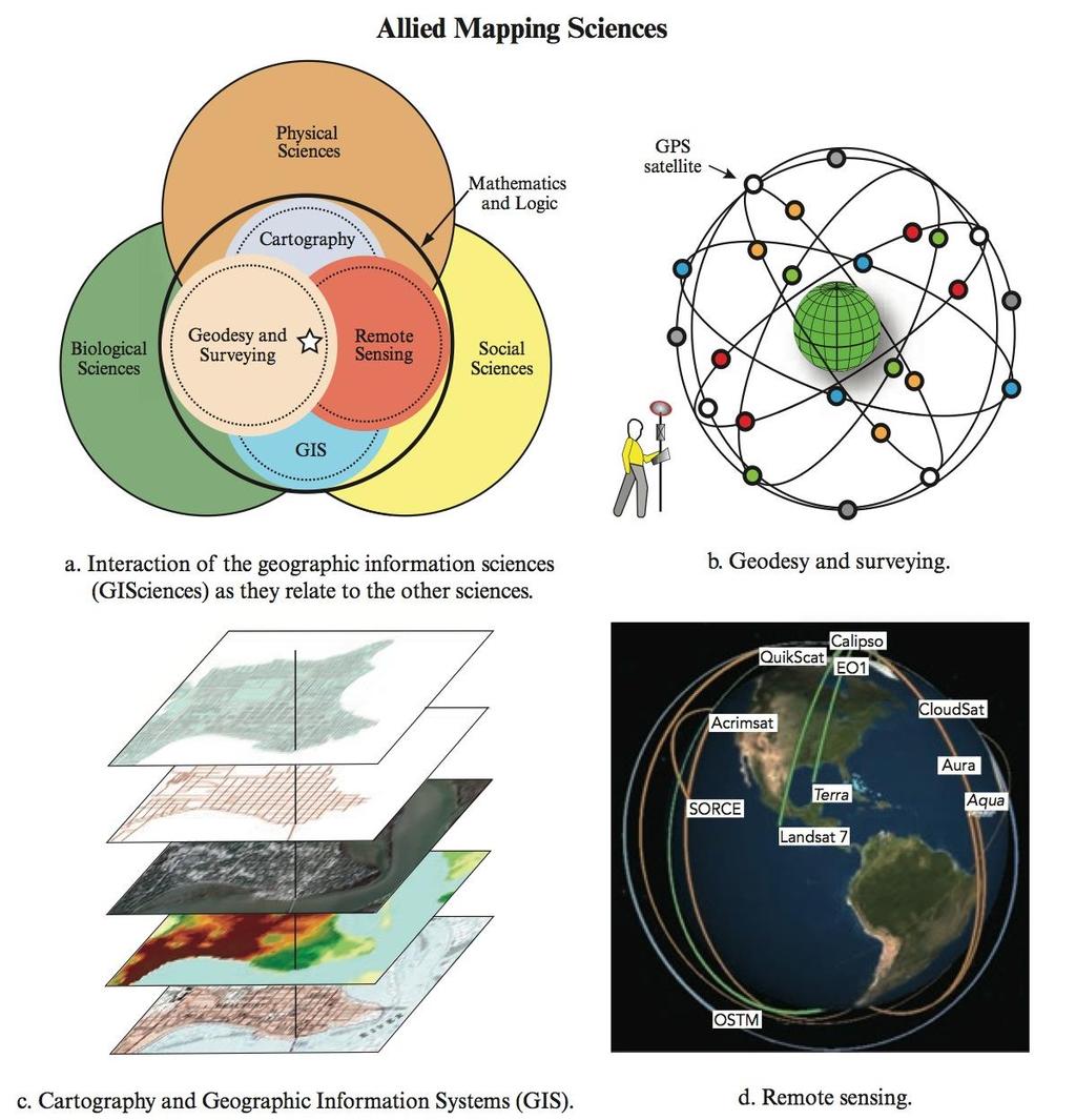
3 Introduction Remote Sensing is the art and science of obtaining information about an object without being in direct physical contact with the object. Sensors may be mounted on satellites, planes or in vehicles. It can be used to measure and monitor important biophysical characteristics and human activities on Earth.
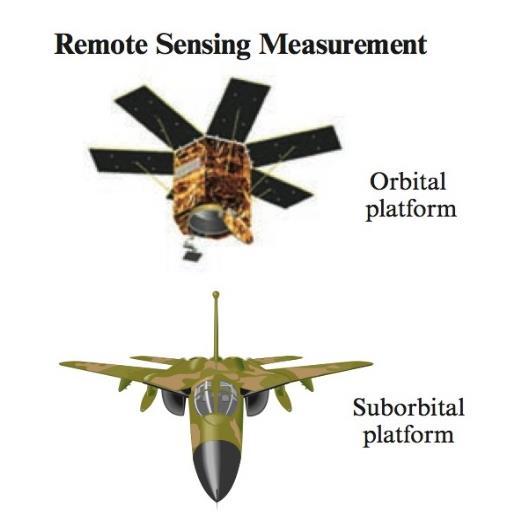
4 Measurement
5
6
7 Remote Sensing - Advantages Remote sensing is unobtrusive if the sensor is passively recording the electromagnetic energy reflected from or emitted by the phenomenon of interest. This is a very important consideration as passive remote sensing does not disturb the object or area of interest. Remote sensing science can provide fundamental, new scientific data or information. Under controlled conditions, remote sensing can provide fundamental biophysical information, including: x, y location, z elevation or depth, bio- mass, temperature, moisture content, etc. The remotely sensed data can be obtained systematically over very large geographic areas, and it has become critical to the successful modeling of numerous natural (e.g., water-supply estimation; eutrophication studies; nonpoint source pollution) and cultural (e.g., land-use conversion at the urban fringe; water-demand estimation; population estimation; food security) processes.
8 Remote Sensing - Limitations Remote sensing science has limitations. Perhaps the greatest limitation is that it is often oversold. Remote sensing is not a panacea that will provide all the information needed to conduct physical, biological, or social science research. It simply provides some spatial, spectral, and temporal information of value in a manner that is hopefully efficient and economical. Powerful active remote sensor systems that emit their own electromagnetic radiation (e.g., LiDAR, RADAR, SONAR) can be intrusive.

9 The Remote Sensing Process


10 Digital Image is made of Pixel picture element

11 Visible spectrum: micro meter or nano meter 1 meter = 10 6 micro meter = 10 9 nano meter

12 Radiation from Sun and Earth black body

13 Spectral Radiance of Sun

14 Radiation Budget
15 Atmosphere Transmission \ Absorption

16 Spectral Bands and Atmospheric Transmission

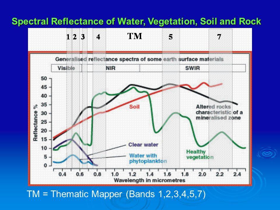
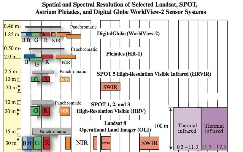
17 LandSat 8 Bands Wave length - Resolution

18 Color Bands and Image

19 Remote Sensor Resolution 10 m 10 m B G Jan 15 R NIR Feb 15 Spatial - the size of the field-of-view, e.g. 10 x 10 m. Spectral - the number and size of spectral regions the sensor records data in, e.g. blue, green, red, near-infrared thermal infrared, microwave (radar). Temporal - how often the sensor acquires data, e.g. every 30 days. Radiometric - the sensitivity of detectors to small differences in electromagnetic energy. Jensen, 2000


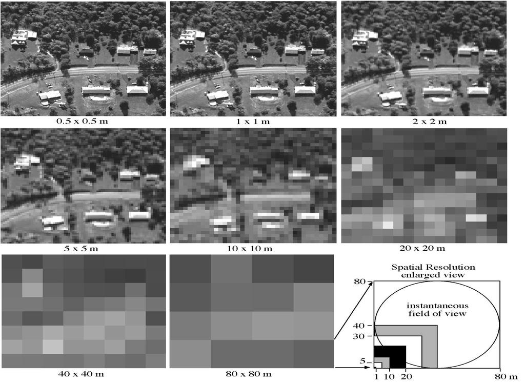
20 Jensen, 2000 Spatial Resolution

21 Monitor TV 3 Color Guns Band combinations

22 A Satellite gathered remote sensing image
23
24
25
26

27 Remote Sensing - Applications Earth Resource Analysis Perspective Such information may be useful for modeling: the global carbon cycle, biology and biochemistry of ecosystems, aspects of the global water and energy cycle, climate variability and prediction, atmospheric chemistry, characteristics of the solid Earth, population estimation, and monitoring land-use change and natural hazards.


28 Sun External Forcing Functions Volcanoes Remote Sensing Earth System Science Stratos pheric Che mistry and Dynamics Phys ical Climate Sys tem Hydrologic Cycle Bio geo chemical Cycle s Ocean dynamics Marine biogeochemistry Atmospheric physics and dynamics Global moisture Tropospheric chemistry Terrestrial energy and moisture Soil and water chemistry Terrestrial ecosystems Climate Change Carbon Dio xide and Other Trace Gas e s Water pollution Air pollution Land use Human Activities Jensen, 2000

29

30 Nepal: NW 31N 80 E SE 26 N 89 E

31 Kathmandu Bagmati River
32 A LandSat Image Kathmandu area Size 185 Km Square Need 12 images to cover Nepal

33 Remote Sensing Image Kathmandu & Bagmati River Natural Color
34 Remote sensing Image False Color Green - blue, Red - green, Infra Red - red
35 Remote Sensing can be used as a tool for site-specific management of crops, by estimating characteristics of soils, crops, plant stress, and effects of fertilizer, tillage etc. (W Casady & HL Palm) + Soil brightness - Construct soil maps or direct soil sampling + Crop vigor or health - Several uses + Vegetation cover - Replant decisions + Chlorophyll content - Nitrogen management + Yield prediction - General management + Weed escapes - Weed management + Stress due to canopy - Irrigation management moisture deficits + Crop residue - Compliance with erosion prevention guidelines
36
37
38 Multi-spectral broad-band vegetation indices available for use in precision agriculture. (DJ Mulla) Index Definition Reference NG G/(NIR + R + G) Sripada et al., 2006 NR R/(NIR + R + G) Sripada et al., 2006 RVI NIR/R Jordan, 1969 GRVI NIR/G Sripada et al., 2006 DVI NIR R Tucker, 1979 GDVI NIR G Tucker, 1979 NDVI (NIR R)/(NIR + R) Rouse et al., 1973 GNDVI (NIR G)/(NIR + G) Gitelson et al., 1996 SAVI 1.5*[(NIR R)/(NIR + R + 0.5)] Huete, 1988 GSAVI 1.5*[(NIR G)/(NIR + G + 0.5)] Sripada et al., 2006 OSAVI (NIR R)/(NIR + R ) Rondeaux, Steven, & Baret, 1996 GOSAVI (NIR G)/(NIR + G ) Sripada et al., 2006 MSAVI2 0.5*[2*(NIR + 1) SQRT ((2*NIR + 1) 2 8*(NIR R))] Qi, Chehbouni, Huete, Keer, & Sorooshian, 1994
39 Innovations in remote and proximal leaf sensing in precision agriculture. (DJ Mulla) Year Innovation Citation 1992 SPAD meter (650, 940 nm) used to detect N deficiency in corn Schepers et al., Nitrogen sufficiency indices Blackmer & Schepers, Optical sensor (671, 780 nm) used for on-the-go detection of variability in plant nitrogen stress Stone et al., Yara N sensor Link et al., 2002, TopCon industries 2002 GreenSeeker (650, 770 nm) Raun et al., 2002, NTech industries 2004 Crop Circle (590, 880 nm or 670, 730, 780 nm) Holland et al., 2004, Holland scientific 2002 CASI hyperspectral sensor based index measurements of chlorophyll Haboudane et al., 2002, MSS remote sensing of ag fields with UAV Herwitz et al., Fluorescence sensing for N deficiencies Apostol et al., 2003
40 Narrow band Hyperspectral Vegetation Indices: These indices variously respond to canopy or leaf scale effects of leaf area index, chlorophyll, specific pigments, or nitrogen stress. Aerial hyperspectral imagery has revolutionized the ability to distinguish multiple crop characteristics, including nutrients, water, pests, diseases, weeds, biomass and canopy structure. Ground-based sensors have been developed for on-the-go monitoring of crop and soil characteristics such as N stress, water stress, soil organic matter and moisture content. (DJ Mulla) Index Definition Greenness index (G) R 554 /R 677 SR1 NIR/red = R 801 /R 670 SR2 NIR/green = R 800 /R 550 SR3 R 700 /R 670 SR4 R 740 /R 720 SR5 R 675 /(R 700 *R 650 ) SR6 R 672 /(R 550 *R 708 ) SR7 R 860 /(R 550 *R 708 ) DI1 R 800 R 550
41 NDVI (R 800 R 680 )/(R R 680 ) Green NDVI (GNDVI) (R 801 R 550 )/(R R 550 ) PSSRa R 800 /R 680 PSSRb R 800 /R 635 NDI1 (R 780 R 710 )/(R 780 R 680 ) NDI2 (R 850 R 710 )/(R 850 R 680 ) NDI3 (R 734 R 747 )/(R R 726 ) MCARI [(R 700 R 670 ) 0.2(R 700 R 550 )](R 700 /R 670 ) TCARI 3*[(R 700 R 670 ) 0.2*(R 700 R 550 )(R 700 /R 670 )] OSAVI ( )(R 800 R 670 )/(R R )
42 TCARI/OSAVI TVI 0.5*[120*(R 750 R 550 ) 200*(R 670 R 550 )] MCARI/OSAVI RDVI (R 800 R 670 )/SQRT(R R 670 ) MSR (R 800 /R 670 1)/SQRT(R 800 /R ) MSAVI 0.5[2R SQRT((2R ) 2 8(R 800 R 670 ))] MTVI 1.2*[1.2*(R 800 R 550 ) 2.5*(R 670 R 550 )] MCARI2 1.5[2.5(R800 R670) 1.3(R800 R550)](2R800+1)2 (6R800 5R67 0) 0.5
43 In Nepal, it will be good to have a remote sensing program, with following issues put together. Applications: Agriculture, Forestry, Meteorology, Geology, Planning Satellite Imagery: USA LandSat etc., Indian and others Overlapping need based multiuse imagery by season & location Developing network of sample plots for various uses & locations Continuous process of application, evaluation and innovation
44 Thank you!!! Questions???
Remote Sensing in Precision Agriculture
 Remote Sensing in Precision Agriculture D. J. Mulla Professor and Larson Chair for Soil & Water Resources Director Precision Ag Center Dept. Soil, Water, & Climate Univ. Minnesota Challenges Facing Agriculture
Key Advances and Remaining. for Precision Agriculture
 Key Advances and Remaining Knowledge Gaps in Remote Sensing for Precision Agriculture D. J. Mulla Professor and Larson Chair for Soil and Water Resources Director Precision Agriculture Center Dept. Soil,
Iowa Soybean Association Farmer Research Conference
 Iowa Soybean Association Farmer Research Conference February 7, 2018 Josh Pritsolas and Randy Pearson, Ph.D. Laboratory for Applied Spatial Analysis (LASA) Southern Illinois University Edwardsville Edwardsville,
Optical Sensing of Crop N
 Optical Sensing of Crop N Under Water-Limited Conditions Dan Long and John McCallum USDA-ARS Pendleton, Oregon In-Season N Management Applying fertilizer N based on information acquired during the growing
NDVI for Variable Rate N Management in Corn
 NDVI for Variable Rate N Management in Corn David Mulla, Ph.D. Director Precision Ag. Center Dept. Soil, Water & Climate University of Minnesota Co-authors: Aicam Laacouri, Tyler Nigon and Jeff Vetsch
Integrating remote-, close range- and in-situ sensing for highfrequency observation of crop status to support precision agriculture
 Sensing a Changing World 2012 Integrating remote-, close range- and in-situ sensing for highfrequency observation of crop status to support precision agriculture Lammert Kooistra 1 *, Eskender Beza 1,
PERFORMANCE OF TWO ACTIVE CANOPY SENSORS FOR ESTIMATING WINTER WHEAT NITROGEN STATUS IN NORTH CHINA PLAIN
 PERFORMANCE OF TWO ACTIVE CANOPY SENSORS FOR ESTIMATING WINTER WHEAT NITROGEN STATUS IN NORTH CHINA PLAIN Qiang Cao, Yuxin Miao*, Xiaowei Gao, Guohui Feng and Bin Liu International Center for Agro-Informatics
A Comparison of Two Approaches for Estimating the Wheat Nitrogen Nutrition Index Using Remote Sensing
 Remote Sens. 2015, 7, 4527-4548; doi:10.3390/rs70404527 Article OPEN ACCESS remote sensing ISSN 2072-4292 www.mdpi.com/journal/remotesensing A Comparison of Two Approaches for Estimating the Wheat Nitrogen
Utilizing normalized difference vegetation indices (NDVI) and in-season crop and soil variables to estimate corn grain yield.
 and in-season crop and soil variables to estimate corn grain yield.") Utilizing normalized difference vegetation indices (NDVI) and in-season crop and soil variables to estimate corn grain yield. T.M. Shaver, R. Khosla, and D.G. Westfall Department of Soil and Crop Sciences,
Utilizing normalized difference vegetation indices (NDVI) and in-season crop and soil variables to estimate corn grain yield. T.M. Shaver, R. Khosla, and D.G. Westfall Department of Soil and Crop Sciences,
MULTI-SOURCE SPECTRAL APPROACH FOR EARLY WATER-STRESS DETECTION IN ACTUAL FIELD IRRIGATED CROPS
 Department of Geography and Environmental Studies MULTI-SOURCE SPECTRAL APPROACH FOR EARLY WATER-STRESS DETECTION IN ACTUAL FIELD IRRIGATED CROPS Maria Polinova 1, Thomas Jarmer 2, Anna Brook 1 1 Spectroscopy
Researcher 2017;9(12)
") Obtaining NDVI zoning map of SEBAL model during harvesting season in Salman Farsi sugarcane cultivation fields Sh. Kooti 1, A. Naseri 2, S.Boroomand Nasab 3 1 M. Sc. Student of Irrigation and Drainage,
Obtaining NDVI zoning map of SEBAL model during harvesting season in Salman Farsi sugarcane cultivation fields Sh. Kooti 1, A. Naseri 2, S.Boroomand Nasab 3 1 M. Sc. Student of Irrigation and Drainage,
Remote Sensing (C) Team Name: Student Name(s):
 Team Name: Student Name(s):") Team Name: Student Name(s): Remote Sensing (C) Nebraska Science Olympiad Regional Competition Henry Doorly Zoo Saturday, February 27 th 2010 96 points total Please answer all questions with complete sentences
Team Name: Student Name(s): Remote Sensing (C) Nebraska Science Olympiad Regional Competition Henry Doorly Zoo Saturday, February 27 th 2010 96 points total Please answer all questions with complete sentences
Using in-situ measurements to evaluate the new RapidEye TM satellite series for prediction of wheat nitrogen status
 International Journal of Remote Sensing Vol. 28, No., Month 7, 1 8 International Journal of Remote Sensing res1211.3d /6/7 14:1:12 The Charlesworth Group, Wakefield +44()1924 36998 - Rev 7.1n/W (Jan 3)
Institute of Ag Professionals
 Institute of Ag Professionals Proceedings of the 2006 Crop Pest Management Shortcourse & Minnesota Crop Production Retailers Association Trade Show www.extension.umn.edu/agprofessionals Do not reproduce
QUANTIFYING CORN N DEFICIENCY WITH ACTIVE CANOPY SENSORS. John E. Sawyer and Daniel W. Barker 1
 QUANTIFYING CORN N DEFICIENCY WITH ACTIVE CANOPY SENSORS John E. Sawyer and Daniel W. Barker 1 Precision agriculture technologies are an integral part of many crop production operations. However, implementation
Sensor Based Fertilizer Nitrogen Management. Jac J. Varco Dept. of Plant and Soil Sciences
 Sensor Based Fertilizer Nitrogen Management Jac J. Varco Dept. of Plant and Soil Sciences Mississippi State University Nitrogen in Cotton Production Increased costs linked to energy costs Deficiency limits
CROP STATE MONITORING USING SATELLITE REMOTE SENSING IN ROMANIA
 CROP STATE MONITORING USING SATELLITE REMOTE SENSING IN ROMANIA Dr. Gheorghe Stancalie National Meteorological Administration Bucharest, Romania Content Introduction Earth Observation (EO) data Drought
REMOTE SENSING: DISRUPTIVE TECHNOLOGY IN AGRICULTURE? DIPAK PAUDYAL
 Place image here (13.33 x 3.5 ) REMOTE SENSING: DISRUPTIVE TECHNOLOGY IN AGRICULTURE? DIPAK PAUDYAL Principal Consultant, Remote Sensing- Esri Australia Adjunct Associate Prof., University of Queensland
Use of Reflectance Sensors to Optimise Nutrient Management.
 Use of Reflectance Sensors to Optimise Nutrient Management. Ian Yule and Reddy Pullanagari. NZ Centre for Precision Agriculture, Massey University, Palmerston North. i.j.yule@massey.ac.nz Abstract. There
Monitoring maize N status with airborne and ground level sensors
 Monitoring maize N status with airborne and ground level sensors M. QUEMADA, J.L. GABRIEL, P. ZARCO-TEJADA, J. LÓPEZ-HERRERA, E. PÉREZ-MARTÍN, M. ALONSO-AYUSO School of Agricultural Engineering, Technical
ABSTRACT. SRIPADA, RAVI PRAKASH. Determining In-Season Nitrogen Requirements for Corn
 ABSTRACT SRIPADA, RAVI PRAKASH. Determining In-Season Nitrogen Requirements for Corn Using Aerial Color-Infrared Photography. (Under the direction of Ronnie W. Heiniger and Jeffrey G. White) Fast, accurate
9-April-2013 Linden, AB Improved In-Crop Variable Rate N Application
 9-April-2013 Linden, AB Improved In-Crop Variable Rate N Application Tom Jensen tjensen@ipni.net A not-for-profit, scientific organization dedicated to responsible management of plant nutrients for the
Farming from Space: Current and future opportunities for remote sensing to boost productivity for grain growers
 Farming from Space: Current and future opportunities for remote sensing to boost productivity for grain growers Hamlyn G Jones Division of Plant Sciences and University of Dundee, UK School of Plant Biology
Overview of Land Surface Parameters From Earth Observation
 Overview of Land Surface Parameters From Earth Observation Prof. Dr. Christiane Schmullius Friedrich Schiller University Jena, Germany Department of Geoinformatics and Remote Sensing FSU Jena Institut
Assessing on estimates of biomass in forest areas
 Assessing on estimates of biomass in forest areas Carlos Antônio Oliveira Vieira, Aurilédia Batista Teixeira, Thayse Cristiane Severo do Prado, Fernando Fagundes Fontana, Ramon Vitto, Federal University
Satellite Earth Observation
 Satellite Earth Observation Services for Ecosystem valuation Prof Nick Veck Head of the CEO s Office Satellite Applications Catapult 17 March 2017 Outline Introduction to Earth observation and ecosystem
11. Precision Agriculture
 Precision agriculture for crop production can be defined as a management system that: is information- and technology-based is site-specific uses one or more of the following sources of data for optimum
Measuring canopy nitrogen nutrition in tobacco plants using hyper spectrum parameters
 Measuring canopy nitrogen nutrition in tobacco plants using hyper spectrum parameters Yong Zou, Xiaoqing YE, et al. Shenzhen Tobacco Ind. Co., Ltd. of CNTC Layout Background Experimental Program Experimental
Red and amber normalized difference vegetation index (NDVI) ground-based active remote sensors for nitrogen management in irrigated corn.
 ground-based active remote sensors for nitrogen management in irrigated corn.") Red and amber normalized difference vegetation index (NDVI) ground-based active remote sensors for nitrogen management in irrigated corn. T.M. Shaver, R. Khosla, and D.G. Westfall Department of Soil and
Red and amber normalized difference vegetation index (NDVI) ground-based active remote sensors for nitrogen management in irrigated corn. T.M. Shaver, R. Khosla, and D.G. Westfall Department of Soil and
UAS In Agriculture A USDA NIFA Perspective; Appropriate Science, Possibilities, and Current Limitations
 UAS In Agriculture A USDA NIFA Perspective; Appropriate Science, Possibilities, and Current Limitations Steven J. Thomson, Ph.D National Program Leader Background Faculty member at Virginia Tech for seven
3/1/18 USING RADAR FOR WETLAND MAPPING IMPORTANCE OF SOIL MOISTURE TRADITIONAL METHODS TO MEASURE SOIL MOISTURE. Feel method Electrical resistance
 3/1/18 USING RADAR FOR WETLAND MAPPING SOIL MOISTURE AND WETLAND CLASSIFICATION Slides modified from a presentation by Charlotte Gabrielsen for this class. Southeast Arizona: Winter wet period From C.
Uso de imágenes hiper y multi-espectrales para el ajuste de la fertilización nitrogenada en cultivo de maíz
 Uso de imágenes hiper y multi-espectrales para el ajuste de la fertilización nitrogenada en cultivo de maíz J.L. GABRIEL, P. ZARCO-TEJADA, J. LÓPEZ-HERRERA, E. PÉREZ-MARTÍN, M. ALONSO-AYUSO, M. QUEMADA
Fluid Fertilizers to Manage In-Season N Using Site-Specific Management Zones and On-the-Go Active Remote Sensing
 Fluid Fertilizers to Manage In-Season N Using Site-Specific Management Zones and On-the-Go Active Remote Sensing Tim Shaver, R. Khosla and D.G. Westfall Department of Soil and Crop Sciences Introduction:
COMPARATIVE STUDY OF NDVI AND SAVI VEGETATION INDICES IN ANANTAPUR DISTRICT SEMI-ARID AREAS
 International Journal of Civil Engineering and Technology (IJCIET) Volume 8, Issue 4, April 2017, pp. 559 566 Article ID: IJCIET_08_04_063 Available online at http://www.iaeme.com/ijciet/issues.asp?jtype=ijciet&vtype=8&itype=4
Research and Applications using Realtime Direct Broadcast Imagery, Weather Radar, and LiDAR in Disaster Response and Preparedness
 Research and Applications using Realtime Direct Broadcast Imagery, Weather Radar, and LiDAR in Disaster Response and Preparedness Richard P. Watson, Ph.D. University of New Mexico Earth Data Analysis Center
Nitrogen Diagnostic Tools in Corn Production. John E. Sawyer Professor Soil Fertility Extension Specialist Department of Agronomy
 Nitrogen Diagnostic Tools in Corn Production John E. Sawyer Professor Soil Fertility Extension Specialist Department of Agronomy Evaluating Plant-Available N Soil N mineralization / soil supply Indirect
How are these equations relevant to remotely sensed data? Source: earthsci.org/rockmin/rockmin.html
 Lecture 3 How does light give us information about environmental features Revision Select a different scoop from last week Post the key points as a reaction to http://www.scoop.it/t/env22-52-w2 (need to
2011 GIS Symposium 1
 2011 GIS Symposium 1 What is Thermal Imaging? Infrared radiation is perceived as heat Heat is a qualitative measure of temperature Heat is the transfer of energy Energy can be quantitatively i measured
Multi temporal remote sensing for yield prediction in sugarcane crops
 Multi temporal remote sensing for yield prediction in sugarcane crops Dr Moshiur Rahman and A/P Andrew Robson (Principal Researcher) Precision Agriculture Research Group, University of New England, NSW,
Remote Sensing of Land & Vegetation. C S Murthy
 Remote Sensing of Land & Vegetation C S Murthy Remote Sensing current status New era of RS in 21 st Century Increased utilisation of data Quantitative algorithms/improved retrieval methods Better calibrations
Estimation of chlorophyll-a concentration in estuarine waters:
 Estimation of chlorophyll-a concentration in estuarine waters: case study of the Pearl River estuary Yuanzhi Zhang *, Chuqun Chen #, Hongsheng Zhang *, Xiaofei*, Chen Guiying Chen# *Institute of Space
Current use and potential of satellite imagery for crop production management
 Current use and potential of satellite imagery for crop production management B. de Solan, A.D. Lesergent, D. Gouache, F. Baret June 4th, 2012 Increasing needs in observation data to optimize crop production
ANALYSIS OF BACKGROUND VARIATIONS IN COMPUTED SPECTRAL VEGETATION INDICES AND ITS IMPLICATIONS FOR MAPPING MANGROVE FORESTS USING SATELLITE IMAGERY
 ANALYSIS OF BACKGROUND VARIATIONS IN COMPUTED SPECTRAL VEGETATION INDICES AND ITS IMPLICATIONS FOR MAPPING MANGROVE FORESTS USING SATELLITE IMAGERY Beata D. BATADLAN 1, Enrico C. PARINGIT 2, Jojene R.
Field phenotyping: affordable alternatives. J.L. Araus, S C. Kefauver, O. Vergara, S. Yousfi, A.K. Elazab, M.D. Serret, J. Bort
 Field phenotyping: affordable alternatives J.L. Araus, S C. Kefauver, O. Vergara, S. Yousfi, A.K. Elazab, M.D. Serret, J. Bort Context Field phenotyping Proximal sensing & imaging: affordable alternatives
USING PRECISION AGRICULTURE AND REMOTE SENSING TECHNIQUES TO IMPROVE GENOTYPE SELECTION IN A BREEDING PROGRAM
 USING PRECISION AGRICULTURE AND REMOTE SENSING TECHNIQUES TO IMPROVE GENOTYPE SELECTION IN A BREEDING PROGRAM F. A. Rodrigues Junior 1, I. Ortiz-Monasterio 1, P. J. Zarco-Tejada 2, K. Ammar 1, B. Gérard
MODULE 8 LECTURE NOTES 5 REMOTE SENSING APPLICATIONS IN DROUGHT ASSESSMENT
 MODULE 8 LECTURE NOTES 5 REMOTE SENSING APPLICATIONS IN DROUGHT ASSESSMENT 1. Introduction Drought is a phenomenon of long-term moisture deficiency. It may be meteorological, agricultural or hydrologic
The role of Remote Sensing in Irrigation Monitoring and Management. Mutlu Ozdogan
 The role of Remote Sensing in Irrigation Monitoring and Management Mutlu Ozdogan Outline Why do we care about irrigation? Remote sensing for irrigated agriculture What are the needs of irrigators? Future
8/21/13. Outline. Feasibility of measuring individual trees using remote sensing. Introduction. Introduction -definition -usage -limitation
 Feasibility of measuring individual trees using remote sensing Mega Binti Abang PhD Candidate University of Tennessee Department of Forestry, Wildlife and Fisheries Room 160 Plant Biotech Building Wednesday
Land Surface Monitoring from the Moon
 Land Surface Monitoring from the Moon Jack Mustard, Brown University Workshop on Science Associated with Lunar Exploration Architecture Unique Perspective of Lunar Observation Platform Low Earth Orbit:
Department of Environmental Sciences, Nanjing Institute of Meteorology, Nanjing , China
 Evaluation of Remote Sensing Approaches to Monitor Crop Conditions under Specific Input Levels and Cropping Diversity X. Guo 1, Y. Zheng 1,4, O. Olfert 2, S. Brandt 3, A.G. Thomas 2, R.M. Weiss 2, L. Sproule
European Forest Fire Information System (EFFIS) - Rapid Damage Assessment: Appraisal of burnt area maps with MODIS data
 - Rapid Damage Assessment: Appraisal of burnt area maps with MODIS data") European Forest Fire Information System (EFFIS) - Rapid Damage Assessment: Appraisal of burnt area maps with MODIS data Paulo Barbosa European Commission, Joint Research Centre, Institute for Environment
European Forest Fire Information System (EFFIS) - Rapid Damage Assessment: Appraisal of burnt area maps with MODIS data Paulo Barbosa European Commission, Joint Research Centre, Institute for Environment
Options for in-season adjustment of nitrogen rate for corn
 213 Integrated Crop Management Conference - Iowa State University 145 Options for in-season adjustment of nitrogen rate for corn John E. Sawyer, professor and Extension soil fertility specialist, Agronomy,
Term Project December 5, 2006 EES 5053: Remote Sensing, Earth and Environmental Science, UTSA
 Term Project December 5, 2006 EES 5053: Remote Sensing, Earth and Environmental Science, UTSA Applying Remote Sensing Techniques to Identify Early Crop Infestation: A Review Abstract: Meaghan Metzler In
Opportunities for Improved Crop Management Using Remote Sensing
 FDL Forage Growers Meeting Opportunities for Improved Crop Management Using Remote Sensing December 17, 2015 Brian D. Luck, Ph.D. Assistant Professor and Extension Specialist Biological Systems Engineering
Integral Methods of Environmental Assessment at Mining Regions Based on Remote Sensing Data
 Integral Methods of Environmental Assessment at Mining Regions Based on Remote Sensing Data Giniyatullina O.L., Potapov V.P., Schactlivtcev E.L. Institute of Computational Technologies Siberian Branch
ASSESSING BIOMASS YIELD OF KALE (BRASSICA OLERACEA VAR. ACEPHALA L.) FIELDS USING MULTI-SPECTRAL AERIAL PHOTOGRAPHY
 FIELDS USING MULTI-SPECTRAL AERIAL PHOTOGRAPHY") ASSESSING BIOMASS YIELD OF KALE (BRASSICA OLERACEA VAR. ACEPHALA L.) FIELDS USING MULTI-SPECTRAL AERIAL PHOTOGRAPHY Jaco Fourie, Armin Werner and Nicolas Dagorn Lincoln Agritech Ltd, Canterbury, New Zealand
ASSESSING BIOMASS YIELD OF KALE (BRASSICA OLERACEA VAR. ACEPHALA L.) FIELDS USING MULTI-SPECTRAL AERIAL PHOTOGRAPHY Jaco Fourie, Armin Werner and Nicolas Dagorn Lincoln Agritech Ltd, Canterbury, New Zealand
Detection of Sclerotinia rot incidence in indian mustard from polar orbiting satellite platform
 PLANT PROTECTION: Diseases 79 Detection of Sclerotinia rot incidence in indian mustard from polar orbiting satellite platform B. K. Bhattacharya 1, C. Chattopadhyay 2, S. Dutta 1, R. L. Meena 2, Sumana
Application of remote sensing technique for rice precision farming
 Application of remote sensing technique for rice precision farming Teoh Chin Chuang (DR) Chan Chee Wan (DR) Abu Hassan Daud Malaysian Agricultural Research and Development Institute (MARDI) Background:
Drone sensing A new perspective on cereal disease management? David Whattoff - Agricultural Development Manager
 Drone sensing A new perspective on cereal disease management? David Whattoff - Agricultural Development Manager SOYL Precision Ag National coverage Provide application plans to 1,000,000 ha per year PA
The NISAR Mission. Paul Siqueira Emerging Technologies and Methods in Earth Observation for Agriculture Monitoring College Park, 2018
 The NISAR Mission Paul Siqueira Emerging Technologies and Methods in Earth Observation for Agriculture Monitoring College Park, 2018 Flyer A one-page paper-flyer is available with more information NISAR
Remote Sensing (C) School Name: Student Name(s):
 School Name: Student Name(s):") School Name: Student Name(s): Remote Sensing (C) Nebraska Science Olympiad State Competition University of Nebraska-Lincoln Saturday, April 2 nd 2011 Question and Answer Sheet 100 points total Show all
School Name: Student Name(s): Remote Sensing (C) Nebraska Science Olympiad State Competition University of Nebraska-Lincoln Saturday, April 2 nd 2011 Question and Answer Sheet 100 points total Show all
Precision Agriculture. John Nowatzki Extension Ag Machine Systems Specialist
 Precision Agriculture John Nowatzki Extension Ag Machine Systems Specialist Precision Agriculture GPS Guidance and Auto-steer Section Control on Sprayers Row Control on Planters and Seeders Yield Monitoring
Role of Remote Sensing in Flood Management
 Role of Remote Sensing in Flood Management Presented by: Victor Veiga (M.Sc Candidate) Supervisors: Dr. Quazi Hassan 1, and Dr. Jianxun He 2 1 Department of Geomatics Engineering, University of Calgary
Hyperion. R=f(x,t,, ) 1. (t) van der Meer and Jong
 1. (t) van der Meer and Jong") 89 00 89 * 89 8 0 0 7 R=f(x,t,,) t x r TM MSS (x) (R) 0000 θ ( (t) van der Meer and Jong. 00 mobasheri@kntu.ac.iry * 89 90 (Ger Iris) Landsat TM Hunt 980 Hunt OH NH CN 980 Lignin IRIS van der Meer and
89 00 89 * 89 8 0 0 7 R=f(x,t,,) t x r TM MSS (x) (R) 0000 θ ( (t) van der Meer and Jong. 00 mobasheri@kntu.ac.iry * 89 90 (Ger Iris) Landsat TM Hunt 980 Hunt OH NH CN 980 Lignin IRIS van der Meer and
A Remote Sensing Based System for Monitoring Reclamation in Well and Mine Sites
 A Remote Sensing Based System for Monitoring Reclamation in Well and Mine Sites Nadia Rochdi (1), J. Zhang (1), K. Staenz (1), X. Yang (1), B. James (1), D. Rolfson (1), S. Patterson (2), and B. Purdy
Nutrient Management. Clain Jones, Extension Soil Fertility Specialist (406)
") Technological Advances in Nutrient Management Clain Jones, Extension Soil Fertility Specialist (406) 994-6076 What can new technologies do for the producer? New technologies can: Assess soil nutrient variability
Technological Advances in Nutrient Management Clain Jones, Extension Soil Fertility Specialist (406) 994-6076 What can new technologies do for the producer? New technologies can: Assess soil nutrient variability
REMOTE SENSING ON GANODERMA DISEASE
 REMOTE SENSING ON GANODERMA DISEASE Nisfariza Mohd Noor Maris Senior Lecturer Department of Geography, University of Malaya KUALA LUMPUR, MALAYSIA Outline Introduc.on Ganoderma BSR Pathological symptom
Agricultural Aerial Services
 Agricultural Aerial Services Satellite Imagery Satellite LOW Imagery RESOLUTION IMAGE LOW RESOLUTION IMAGE Satellite Imagery LOW RESOLUTION IMAGE High Resolution Imagery High Resolution SUPERIOR Imagery
USE OF CROP SENSORS IN WHEAT AS A BASIS FOR APPLYING NITROGEN DURING STEM ELONGATION
 USE OF CROP SENSORS IN WHEAT AS A BASIS FOR APPLYING NITROGEN DURING STEM ELONGATION Rob Craigie and Nick Poole Foundation for Arable Research (FAR), PO Box 80, Lincoln, Canterbury, New Zealand Abstract
30 Years of Tree Canopy Cover Change in Unincorporated and Incorporated Areas of Orange County,
 30 Years of Tree Canopy Cover Change in Unincorporated and Incorporated Areas of Orange County, 1986-2016 Final Report to Orange County July 2017 Authors Dr. Shawn Landry, USF Water Institute, University
Remote Sensing for Monitoring USA Crop Production: What is the State of the Technology
 Remote Sensing for Monitoring USA Crop Production: What is the State of the Technology Monitoring Food Security Threats from Space - A CELC Seminar Centurion, SA 21 April 2016 David M. Johnson Geographer
SIAC Activity 1.2: Advancing Methodologies for Tracking the Uptake and Adoption of Natural Resource Management Technologies in Agriculture
 SIAC Activity 1.2: Advancing Methodologies for Tracking the Uptake and Adoption of Natural Resource Management Technologies in Agriculture Title of the project: Hyperspectral signature analysis: a proof
Using Aerial Imagery for Irrigation Management Jake LaRue Valmont Irrigation, Valley, NE
 Using Aerial Imagery for Irrigation Management Jake LaRue Valmont Irrigation, Valley, NE jlarue@valmont.com Abstract Water, energy and labor resources are often limited and the need for improvements in
Enhancing Water Conservation and Crop Productivity in Irrigated Agriculture
 Enhancing Water Conservation and Crop Productivity in Irrigated Agriculture Kelly R. Thorp Kevin Bronson, Doug Hunsaker, Andrew French USDA-ARS-ALARC, Maricopa, Arizona Background U.S. Department of Agriculture
Guiding Questions. What is acid rain, how is it formed, and what are some of its impacts?
 2201. The atmosphere is a combination of gasses, primarily composed of nitrogen and oxygen with small amounts of other gases such as carbon dioxide, sulfur dioxide, nitrous oxides and many other trace
Evaluating and improving cover crop performance and adoption
 Evaluating and improving cover crop performance and adoption W. Dean Hively U.S. Geological Survey Eastern Geographic Science Center U.S. Department of the Interior U.S. Geological Survey NESARE Cover
Landsat 5 & 7 Band Combinations
 Landsat 5 & 7 Band Combinations By James W. Quinn Landsat 5 (TM sensor) Wavelength (micrometers) Resolution (meters) Band 1 0.45-0.52 30 Band 2 0.52-0.60
AGOG 485/585 APLN 533 Spring 2019
 AGOG 485/585 APLN 533 Spring 2019 Outline Vegetation analysis and related MODIS products Phenology and productivity Fire monitoring using MODIS and VIIRS data Readings: Textbook Chapter 17 FAQ on Vegetation
Precision Agriculture Methods & Cranberry Crop Monitoring with Drones
 Precision Agriculture Methods & Cranberry Crop Monitoring with Drones Presented by: Mike Morellato, M.Sc., GISP Owner, Crop Sensors Remote Sensing and Agriculture Longer history than many realize.of identifying,
Midday Stem Water Potential. Rolston St. Hilaire Plant and Environmental Sciences
 Midday Stem Water Potential Rolston St. Hilaire Plant and Environmental Sciences Ways to improve irrigation Irrigation scheduling When to irrigate How much to apply efficiency in pecans Irrigation scheduling
Using Multispectral Aerial Imagery to Estimate the Growth of Cotton Fertilized With Poultry Litter and Inorganic Nitrogen
 Using Multispectral Aerial Imagery to Estimate the Growth of Cotton Fertilized With Poultry Litter and Inorganic Nitrogen Javed Iqbal E-mail: jiqbal@purdue.edu Postdoc, Dept. of Agronomy, Purdue University
PRECISION AGRICULTURE SERIES TIMELY INFORMATION Agriculture, Natural Resources & Forestry
 PRECISION AGRICULTURE SERIES TIMELY INFORMATION Agriculture, Natural Resources & Forestry March 2011 Management Zones II Basic Steps for Delineation Management zones (MZ) support site specific management
ANALYSIS OF CHANGES IN VEGETATION BIOMASS USING MULTITEMPORAL AND MULTISENSOR SATELLITE DATA
 ANALYSIS OF CHANGES IN VEGETATION BIOMASS USING MULTITEMPORAL AND MULTISENSOR SATELLITE DATA A. Akkartal a*, O. Türüdü a, and F.S. Erbek b a stanbul Technical University, Faculty of Civil Engineering,
ESTIMATION OF NITROGEN OF RICE IN DIFFERENT GROWTH STAGES USING TETRACAM AGRICULTURE DIGITAL CAMERA. M.M. Saberioon, M.S.M. Amin, and A.
 ESTIMATION OF NITROGEN OF RICE IN DIFFERENT GROWTH STAGES USING TETRACAM AGRICULTURE DIGITAL CAMERA M.M. Saberioon, M.S.M. Amin, and A. Gholizadeh Center of Excellence of Precision Farming Faculty of Engineering
COTTON FIELD RELATIONS OF PLANT HEIGHT TO BIOMASS ACCUMULATION AND N-UPTAKE ON CONVENTIONAL AND NARROW ROW SYSTEMS
 COTTON FIELD RELATIONS OF PLANT HEIGHT TO BIOMASS ACCUMULATION AND N-UPTAKE ON CONVENTIONAL AND NARROW ROW SYSTEMS G. Portz, N. de S. Vilanova Jr., R. G. Trevisan, J.P. Molin, C. Portz and L. V. Posada.
Measuring Ocean Color: The Basics
 Measuring Ocean Color: The Basics Radiation of energy from the Sun and the Earth s surface. Recall from previous lectures that the Sun (6000 K), radiates energy in three portions of the energy spectrum:
POSSIBILITY OF GCOM-C1 / SGLI FOR CLIMATE CHANGE IMPACTS ANALYZING
 POSSIBILITY OF GCOM-C1 / SGLI FOR CLIMATE CHANGE IMPACTS ANALYZING Y. Honda* a, M. Moriyama b, M. Hori c, M. Murakami c, A. Ono c, K. Kajiwara a a Center for Environmental Remote Sensing (CEReS), Chiba
Precision Agriculture. for Smart Farming solutions
 Precision Agriculture for Smart Farming solutions What is Precision Agriculture? An integrated agricultural management system incorporating several advanced technologies The technological tools often include
Design of an Agricultural Runoff Monitoring & Incentive System for Maryland
 Design of an Agricultural Runoff Monitoring & Incentive System for Maryland Hoon Cheong, Willie Heart, Lisa Watkins, and Harry Yoo Department of Systems Engineering and Operations Research George Mason
Developing spatial information database for the targeted areas
 Developing spatial information database for the targeted areas 1 Table of Contents Jericho and Al- Auja (Palestine) 1 Background... 3 2 Monitoring the plant biomass using NDVI in Jericho and Al Auja...
GLOBAL MAPPING OF TERRESTRIAL VEGETATION PHOTOSYNTHESIS: THE FLUORESCENCE EXPLORER (FLEX) MISSION
 MISSION") Session WE2.09 - International Spaceborne Imaging Spectroscopy Missions: Updates and News II GLOBAL MAPPING OF TERRESTRIAL VEGETATION PHOTOSYNTHESIS: THE FLUORESCENCE EXPLORER (FLEX) MISSION Jose F. Moreno
Session WE2.09 - International Spaceborne Imaging Spectroscopy Missions: Updates and News II GLOBAL MAPPING OF TERRESTRIAL VEGETATION PHOTOSYNTHESIS: THE FLUORESCENCE EXPLORER (FLEX) MISSION Jose F. Moreno
Mapping water constituents concentrations in estuaries using MERIS full resolution satellite data
 Mapping water constituents concentrations in estuaries using MERIS full resolution satellite data David Doxaran, Marcel Babin Laboratoire d Océanographie de Villefranche UMR 7093 CNRS - FRANCE In collaboration
Investigating ecological patterns and processes in tropical forests using GIS and remote sensing
 Investigating ecological patterns and processes in tropical forests using GIS and remote sensing Carlos Portillo-Quintero Center for Earth Observation Sciences (CEOS) Department of Earth & Atmospheric
Sensitivity of vegetation indices derived from Sentinel-2 data to change in biophysical characteristics
 Sensitivity of vegetation indices derived from Sentinel-2 data to change in biophysical characteristics Dragutin Protić, Stefan Milutinović, Ognjen Antonijević, Aleksandar Sekulić, Milan Kilibarda Department
WHEN SPACE MEETS AGRICULTURE
 WHEN SPACE MEETS AGRICULTURE Image from ESA Sentinel 14-15 November 2016 Matera, Italy Join the conversation #WSMA16 What can Copernicus do for farmers and for the European Agricultural Policy Catharina
OPTIMUM SUGARCANE GROWTH STAGE FOR CANOPY REFLECTANCE SENSOR TO PREDICT BIOMASS AND NITROGEN UPTAKE ABSTRACT
 OPTIMUM SUGARCANE GROWTH STAGE FOR CANOPY REFLECTANCE SENSOR TO PREDICT BIOMASS AND NITROGEN UPTAKE G. Portz, L. R. Amaral and J. P. Molin Biosystems Engineering Department, "Luiz de Queiroz" College of
NORMALIZED RED-EDGE INDEX NEW REFLECTANCE INDEX FOR DIAGNOSTICS OF NITROGEN STATUS IN BARLEY
 NORMALIZED RED-EDGE INDEX NEW REFLECTANCE INDEX FOR DIAGNOSTICS OF NITROGEN STATUS IN BARLEY Novotná K. 1, 2, Rajsnerová P. 1, 2, Míša P. 3, Míša M. 4, Klem K. 1, 2 1 Department of Agrosystems and Bioclimatology,
A Modified Resource Analysis of Very Large Scale PV (VLS-PV) System on the Gobi Desert by a Remote Sensing Approach
 System on the Gobi Desert by a Remote Sensing Approach") A Modified Resource Analysis of Very Large Scale PV (VLS-PV) System on the Gobi Desert by a Remote Sensing Approach Koichiro Sakakibara, Masakazu Ito and Kosuke Kurokawa Tokyo University of Agriculture
A Modified Resource Analysis of Very Large Scale PV (VLS-PV) System on the Gobi Desert by a Remote Sensing Approach Koichiro Sakakibara, Masakazu Ito and Kosuke Kurokawa Tokyo University of Agriculture
The precision orchard?
 The precision orchard? Techniques from precision agriculture and their potential application to seed orchard production & management Chuck Bulmer BC FLNRORD, Vernon Presented to: BC Seed Orchard Association,
Sensors And Image Processing
 Sensors And Image Processing Craig Poling Chief Technology Officer Sentek Systems craigpoling@senteksystems.com (952) 500-3533 Sentek Systems, LLC Sensors For High-Throughput Phenotyping 1 / 32 Platforms